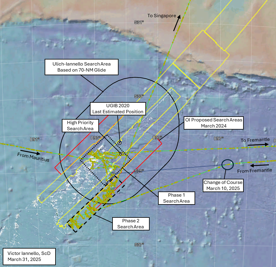
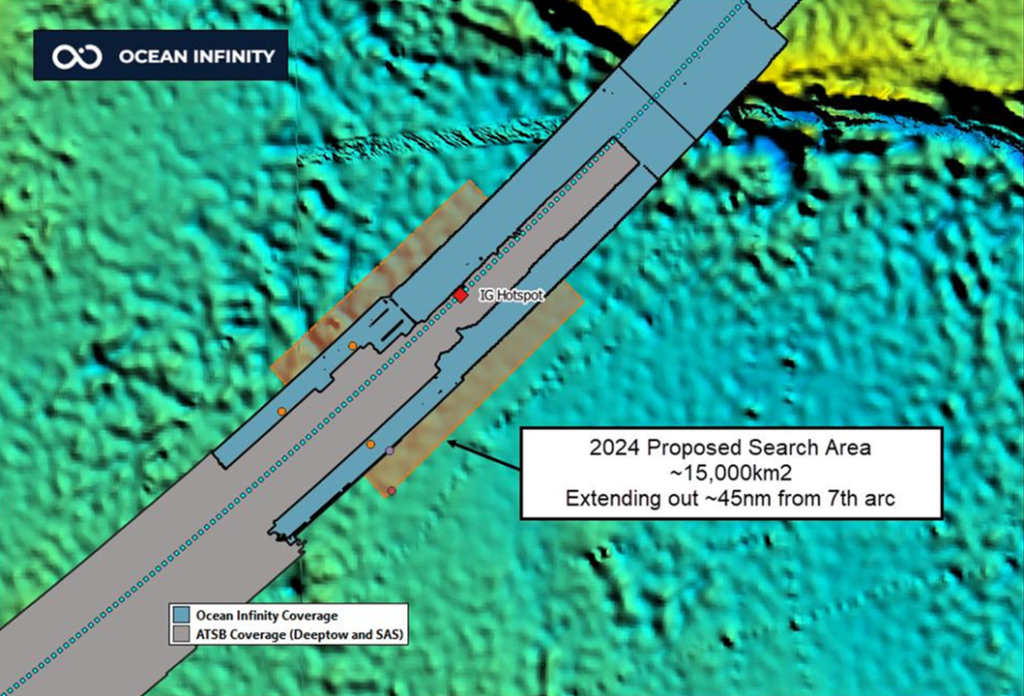
Last year, in March 2024, at a gathering in Malaysia on the 10th anniversary of the disappearance of MH370, family member V.P.R. Nathan presented several slides highlighting Ocean Infinity’s willingness to conduct another subsea search for the debris field of the aircraft. The search area proposed at that time extended along the 7th arc from about 33°S to 36°S, and out to about 45 NM (83 km) on either side of the arc. Ocean Infinity also announced plans to “fill-in” areas that were previously searched that had low quality or missing data due to equipment failures or challenging terrain. The proposed search area surrounded the “Last Estimated Position” (LEP) from UGIB 2020, which was designated the “IG Hotspot” in the slide. The proposed search area also incorporated our High Priority Search Area due south of the LEP that was missed by the previous searches by the ATSB and Ocean Infinity due to the steep sloping terrain in that area.
More recently, there were the following developments:
On December 20, 2024, the Malaysian government agreed “in principle” to a new search effort with Ocean Infinity, indicating the start of formal negotiations.
On March 19, 2025, Malaysia’s Transport Minister Anthony Loke announced that the Malaysian cabinet had agreed to the terms and conditions of the agreement with Ocean Infinity under a “no find, no fee” arrangement, with a payment of $70 million if successful.
On March 26, 2025, a group representing the families of MH370 victims announced that a no-find, no-fee contract was signed by Malaysia and Ocean Infinity. Despite this announcement, there has been no official confirmation from either Malaysia or Ocean Infinity.
In February 2025, with no signed contract in hand, Ocean Infinity began the search that was proposed the year before. After completing two phases of the subsea search, Armada 7806 and its team of three AUVs is now on course to Singapore. Prior to departing for Singapore, the activities conducted during the two phases can be summarized as follows:
Phase 1: After arriving in the search area after departing Mauritius, this phase of the search began on February 23 and was completed on February 28, before departing to Fremantle to reprovision and resupply. The areas searched during this phase (dotted black box in the figure above) were primarily areas previously searched by the ATSB and by Ocean Infinity. Consistent with Ocean Infinity’s proposal from March 2024, the Phase I activities focused on infilling data where challenging terrain such as steep slopes previously resulted in missing or low quality data (data holidays). As such, most of the area in the Phase 1 box was not re-searched. The areas searched in this phase included our “High Priority Search Area”.
Phase 2: After departing Fremantle, Armada 7806 began searching again on March 11 and continued until March 28, before departing for Singapore. The areas searched during this phase (dashed black box in the figure above) were never searched before, starting further southwest and wider than the area proposed by Ocean Infinity in March 2024 (red boxes in the figure above). This would suggest that Ocean Infinity intends to enlarge the search area from what was previously disclosed.
The reasons for Ocean Infinity concluding this part of the search appear to be related to worsening seasonal weather and also related to prior contractual commitments for Armada 7806.
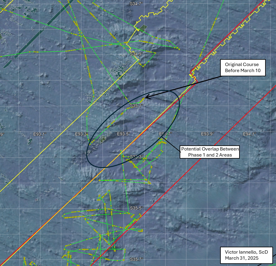
An interesting event occurred during the return to the search area before the start of Phase 2. The course of Armada 7806 was originally towards a part of the area that was searched in Phase 1. Then, on March 10, there was a change in course towards the southwest to begin searching areas not previously covered.
If there was no change in course on March 10, the purple dotted line in the figure above shows where in the Phase 1 search area Armada 7806 would have reached. In fact, our prior article discussed the possibility that Armada 7806 was returning to a debris field that was detected during Phase 1. This area is shown in more detail in the figure below.
Shown in the figure by the black oval is an area that was possibly searched in both Phase 1 and Phase 2, which might mean a promising area required further investigation. However, as we don’t know the exact path that the AUVs followed after launching, there may have been little to no overlap between the Phase 1 and Phase 2 search areas.
So why did Armada 7806’s course change on March 10? Here are two possibilities:
What resembled a debris field was found during Phase 1 and the plan was to revisit that area during Phase II to collect more data. Due to ongoing contract negotiations, OI strategically opted to not disclose the location of the debris field, and the course changed to the southwest. Some additional data in the area of the debris field might have been collected at the end of the Phase 2. (See the potential overlap area in the figure above.) If the debris field was already found, it is unknown whether Ocean Infinity has met the requirements to earn the fee of $70 million, which may require the retrieval of one or more parts of MH370.
No semblance of a debris field was found during Phase 1. Originally the plan was to begin the Phase 2 search where Armada 7806 originally headed and then progressively search to the southwest. For some reason, the plan was changed on March 10 to begin the search to the southwest and progressively search to the northeast, ending where originally planned to begin.
In any event, if the debris field was not found, we are hopeful that Ocean Infinity will return to the search area in November, later this year.
Acknowledgement: This article benefited from ongoing discussions with Mike Exner, Don Thompson, Bobby Ulich, and Andrew Banks.
After a day in port in Fremantle, Australia, to refuel and resupply, Armada 7806 is headed back to the MH370 search area. Based on an average speed of around 10 knots, it should reach there around 02:30 UTC on March 11.
There is a sign that this phase of the search will be shorter than expected: Armada 7806 is self-reporting through Automatic Identification System (AIS) marine tracking that its destination is Cape Town, South Africa. As this is considerably further from the search area than Fremantle, it would make no sense to travel to Cape Town and then return to the search area. A leg to Cape Town would also limit the time that Armada 7806 could spend in the search area, as the port-to-port time is typically less than four weeks.
So why might Armada 7806 be returning to Cape Town after visiting the search area. I offer three possibilities:
During the last phase, something resembling a debris field was detected. If so, Armada 7806 might travel to this spot, launch one or more AUVs, and get better data, including possibly images. After a short time gathering this data, it might travel to Cape Town before it is reassigned a new mission. Another vessel with ROV capability would then be assigned to better document the debris field and perhaps recover some wreckage.
There are ongoing contractual issues between OI and Malaysia and the search will be cut short even if no debris field is detected.
The AIS destination is not correct, either due to an error or due to misdirection.
With the recent announcement by Malaysia saying that the search contract with Ocean Infinity is approved and the signing is imminent, it reduces the probability of (2). Once the contract is signed, we can almost completely eliminate this possibility.
If (3) is correct, we would expect that Armada 7806 would remain in the area for a number of weeks to collect more data and then return to Fremantle. If (1) is correct, the time in the search area will be short. So the length of time that Armada 7806 remains in the search area will tell us a lot.
It is difficult to assign relative probabilities to these three scenarios. Perhaps it is confirmation bias that I believe that (1) is most probable. In any event, we’ll know more in the coming days.
Steep Slope
We can zoom into where Armada 7806 is headed to see why this area might be interesting. Presently (and this could change), Armada 7806’s course is towards a steep slope that was searched with AUVs during the last phase of this search. This steep slope also lies within the areas scanned previously by GO Phoenix using a towfish during the ATSB-managed part of the previous search effort. Parts of this slope were also previously scanned by Ocean Infinity with the vessel Seabed Constructor and its team of seven AUVs. A return to this area once again highlights the difficulty in scanning terrain with steep slopes and other uneven topography, even with AUVs.
The part of the steep slope that seems to be the target is part of the same slope that we designated the High Priority Search Area (HPSA), but further south along that slope. At the time we identified the HPSA, we were not aware that so much more of the slope was not adequately scanned during OI’s last search. If the debris field is truly along this slope, our recommendation to fill-in the low quality data near the 7th arc before extending outwards from the arc was accurate. We said:
As the a) final BFO values, b) the lack of IFE log-on, and c) the end-of-flight simulations all suggest an impact close to the 7th arc, a high priority should be to scan the areas closest to the 7th arc that were either never scanned or have low quality data before searching new areas further from the 7th arc. However, with pilot inputs, it is possible that MH370 glided after fuel exhaustion beyond the areas that were previously scanned. Therefore, searching wider along the 7th arc should also be part of the search plan if areas closer to the 7th arc are unsuccessful in locating the debris field...A steep slope to the south of where UGIB predicts MH370 crossed the 7th arc happens to lie along the extended path of the reconstructed route, and much of this slope remains unscanned. For this reason, the unscanned area surrounding S34.52 E93.84 should be designated a High Priority Search Area.
Although we are speculating about what might take place next based on very limited information, the next several days could prove to be very interesting.
Ocean Infinity (OI) has completed the first phase of its subsea search for MH370 in the Southern Indian along the 7th arc in the Southern Indian Ocean (SIO). As expected, Armada 7806, with its fleet of three autonomous vehicles (AUVs), is searching in the vicinity of the area proposed by OI in March 2024, generally between 34S to 35S latitudes. Armada 7806 is currently in port at Fremantle for refueling and resupplying. It is expected that the turnaround will take around a day, and that Armada 7806 will return to the 7th arc for the second phase of the search.
We know approximately what areas were searched based on the position of Armada 7806 as deduced by AIS reports transmitted via satellite and made available to the public via various marine tracking sites. However, the exact locations searched depend on the track followed by the AUVs after they are launched from the ship during their “sorties”, and this is unknown. Because launches and recoveries while the Armada 7806 is moving slowly or stopped, some additional information can be gleaned by the ship speed.
The figure below shows more details of the search area. Shown in the figure is the sonar data from the first search managed by the ATSB as contracted to Fugro and GO Phoenix (mixed brown shading), the outline (yellow) of the previous search conducted by OI using Seabed Constructor and its team of seven AUVs, and the outline (red) of new areas that OI proposed to search in March 2024. The tracks of Armada 7806 are shown by the circles and connected lines (purple), where the circles are representative of hourly position reports. Where the circles are clumped is indicative of either a launch or recovery of an AUV, which gives us some insight as to the areas searched.
The first location searched was the area we previously designated as the High Priority Search Area, which lies due south of where MH370 was estimated to have crossed the 7th arc, as presented in UGIB 2020. This lies at the border of where OI conducted its previous search. Other areas searched by Armada 7806 were either previously searched by the ATSB or OI. In some cases, Armada 7806 is searching in an area previously searched by BOTH the ATSB and OI.
The reason for re-searching these areas is apparent from the figure below, which includes the terrain features from bathymetry data and shows the spots in which the ATSB sonar data is poor quality, ambiguous, or missing (so-called “data holidays”), depicted as olive-green areas with white outlines. It is apparent that the search so far has focused on “filling in” the areas missed by previous searches, in particular where the terrain was challenging due to steep slopes. Although the AUVs have better ability to follow terrain contours in comparison to the towfish vehicles used by the vessels contracted by the ATSB, the steepest of slopes also present challenges to the AUVs.
Discussion
The search strategy to date is to progressively eliminate large areas that have the highest probability of finding the MH370 debris field. In our opinion, it makes sense to completely eliminate the areas closest to the 7th arc before proceeding outward from the 7th arc into areas not previously searched. The final BFO values at 00:19:29 and 00:19:37 suggest that at these times, MH370 was in a progressively steep descent of around 0.7g downward acceleration. It is possible that the pilot recovered from this dive and glided further from the 7th arc. After infilling the previous data, the search will likely continue into the new areas proposed by OI, which would at least partially consider the dive-glide scenario. Progressively eliminating large areas of seabed is more sensible than jumping between hotspots. Even the High Priority Search Area we recommended only represents an area that we believe has higher relative probability than other areas, but cannot considered to be a “high probability” area because of the many assumptions that were required to reconstruct the UGIB 2020 path.
Finally, we consider the search recommendation presented in Ulich and Iannello (2023), which included the provision for searching outward from the 7th arc to account for a 70-NM glide. This is shown by the black racetrack below, and includes most of the area proposed by OI to search. This would extend past the 15,000 km2 represented by the search area OI proposed in March 2024 (red outline). It would also include the search area recommended by Blely-Marchand, which surrounds 35.6°S, 93.1°E.
It is unclear whether OI will search other areas if the search in this area is unsuccessful.
Ocean Infinity previously conducted a search for MH370 in 2018 using a fleet of Kongsberg Hugin 6000 Autonomous Underwater Vehicles (Hugin AUVs). The AUVs were operated from Seabed Constructor, a vessel designed to support subsea construction activity. Seabed Constructor’s roster of equipment was impressive, a truly multi-purpose subsea vessel: eight Hugin AUVs, acoustic comms and positioning system, two 5000-6000m depth rated (tethered) ROVs, autonomous surface vessels, and a crane able to lift from 3000m deep.
In early 2021 Seabed Constructor’s lease was terminated, along with Normand Frontier, as Ocean Infinity prepared to introduce its fleet of Armada 78 vessels.
The Armada 78 vessels, at 78m length, are smaller than Seabed Constructor. The fleet comprises four distinct operating configurations, none of which involve permanent AUV mobilisation. However, in the context of an MH370 search mission, an Armada 78 can operate Hugin AUVs deployed in a self-contained ISO 668 form factor hangar/garage.
Container module for deploying Hugin AUVs. Image credit: H Henriksen
As of mid-January 2025, four Armada 78 vessels are operating in European waters, one has been operating out of San Diego, California, while three underwent further completions work in Singapore following the experience of those vessels operated in Europe.
While not permanently mobilised to operate AUVs, some Armada 78 vessels have been configured to deploy AUVs: Armada 78-07, from San Diego, to the Clarion-Clipperton Zone, Pacific Ocean; Armada 78-05, surveying pipeline/connector routes in the North Sea and Norwegian Sea; and, Armada 78-06, to the Ryukyu Trench, east of Taiwan, operating out of Kaohsiung port.
Recently, through December 2024-January 2025, much discussion has ensued, speculating on which of the three vessels based in Singapore may be a candidate to conduct a renewed search for MH370 in 2025. One commentator even asserted that Armada 78-08 had been designated as the vessel to conduct the search. Through December 2024 and January 2025 Armada 78-04, 78-06, and 78-08 separately departed Singapore.
Armada 78-04 departed 14th December 2024 fully configured for geotechnical operations with its CPT and vibrocore machines in place and without AUVs. In this configuration, it was not a candidate to conduct the search. After departure from Singapore, Armada 78-04 passed through the Sunda Straits, crossed the Indian Ocean and proceeded to the Atlantic with enroute replenishment and bunkering stops at Port Louis, Mauritius, and Cape Town, South Africa.
Armada 78-06 departed for a task in deep waters east of Taiwan. At departure, it was mobilised with two containerised AUV garages on the aft deck. Upon its return to Singapore, the vessel moored at the ST Engineering facility before departing again on January 19, 2025, and broadcasting Mauritius as its destination. Armada 78-06 passed through the Sunda Straits before establishing a course across the Indian Ocean for Mauritius.
Armada 78-08 had departed for Cape Town with a replenishment and bunkering stop at Port Louis, Mauritius. The vessel is mobilised to operate two Saab Seaeye Leopard ROVs using a LARS over the forward moonpool. These ROVs do not have the ability to operate at the depths found in the MH370 search area. No containerised AUV garages were deployed on the vessel at departure from Singapore.
Following a brief stop in Cape Town, Armada 78-08 departed, this time eastbound to the small port of Mossel Bay where a containerised AUV garage was waiting on the quayside to be loaded onto the vessel. The curious folk of Mossel Bay recorded, on social media, the missing piece of the puzzle to complete the picture of vessel preparation for the MH370 search: Armada 78-08 is ferrying a third AUV to Port Louis where it will be transferred to Armada 78-06 and transit will begin to the search area.
We suspect that delivery of the third container AUV garage was delayed in transshipment to A78-08 at Cape Town. By repositioning Armada 78-08 to Mossel Bay while the intermodal container was delivered by road to the port, any overall delay to the schedule was minimised. Armada 78-08 and 78-06 should arrive at Port Louis within a short time of each other.
While the period required to fully mobilise the additional, third, containerised AUV garage on Armada 78-06 is unknown to us, an estimation of sailing time Mauritius to 7th arc search area is approximately 10 days. Assuming a rendezvous of Armada 78-06 and Armada 78-08 around February 5, and assuming a week to outfit and resupply Armada 78-06, the search might begin around February 22, and perhaps sooner if the time to outfit and re-supply Armada 78-06 occurs faster than one week.
[VI comment: Here are some additional remarks to refute claims that are circulating.]
First, there is no evidence that Malaysia will not sign a contract with OI to search again. Yes, the negotiations seem to be taking longer than any of us would like, and yes, this might reduce the duration of the search compared to the last search, but considering only 15,000 km2 of area is proposed, the shorter duration of the search might not matter. The claim that Malaysia is not interested in searching again is at best premature, and most likely it is false.
Second, there is much speculation about the trajectory of Armada 78-08, which some believe is the vessel designated for the search. More likely, that is not the selected vessel for the search. As Don deduces in the article above, Armada 78-06 is more suitably designed and outfitted for the search.
Thirdly, there is no reason to believe that the search area will be very much different than what OI proposed in March of last year (2024), as shown at the top of the prior post. That area is largely consistent with the Zone 2 search recommendation proposed in Ulich and Iannello (2023). We also hope that OI will have the willingness and capability to search the steep slope at around 33 km (18 NM) due south of our best estimate of where MH370 crossed the 7th arc. This area, centered around S34.53° E93.84°, was not previously searched by either the ATSB or OI, and remains a high priority despite the challenging terrain, as discussed in this previous post.
So, although there are still many unknowns regarding the search, including the precise start date, I still believe it is likely that a search contract will be signed and the search will proceed without many surprises.
On Sunday, MH370 family member V.P.R. Nathan presented several slides highlighting Ocean Infinity’s willingness to conduct another subsea search for the debris field of the aircraft. The search area, which may be refined later, extends along the 7th arc from about 33°S to 36°S, and out to about 45 NM (83 km) on either side of the arc. Ocean Infinity also plans to “fill-in” areas that were previously searched that had low quality or missing data due to equipment failures or challenging terrain.
The proposal is broadly consistent with the flight reconstruction and recommended search area that we presented in UGIB 2020 and the subsequent drift study. In fact, the “Last Estimated Position” (LEP) presented in those studies is designated the “IG Hotspot” in the slide. The proposed search area will also incorporate our high priority area due south of the LEP that was missed by the previous searches by the ATSB and Ocean Infinity due to the steeply sloping terrain in that area.
So, will Malaysia accept Ocean Infinity’s offer to conduct another search with the proposed terms of “no-find, no-fee”? At Sunday’s event, Transport Minister Anthony Loke expressed an interest in discussing the new proposal with Ocean Infinity. However, both he and Malaysian Prime Minister Anwar Ibrahim cautioned that a new search would be conducted only if there was “credible new evidence”. So, although we may be seeing progress towards a new search, it is unclear whether or not Malaysia will accept Ocean Infinity’s proposal.
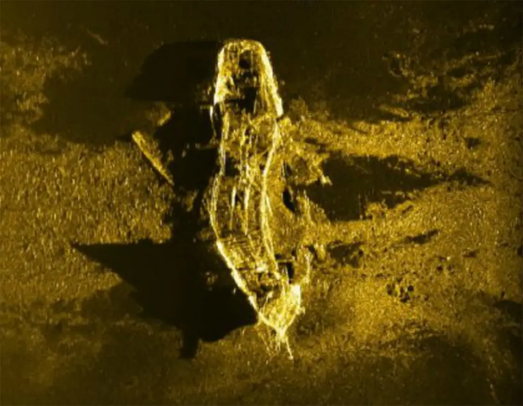
A shipwreck found during the subsea search for MH370
The total subsea search for MH370 comprised more than 240,000 km2 of seabed in the Southern Indian Ocean (SIO) along the 7th arc, which is derived from the metadata from the last transmission from MH370’s SATCOM terminal. The search of the first 120,000 km2 was managed by the Australian Transport and Safety Bureau (ATSB), and included the areas that Australia’s Defense Science and Technology Group (DSTG) deemed most likely as the Point of Impact (POI). The ATSB’s subsea search along the 7th arc extended in latitude from 39.4 S to 32.8 S, varying in width from 130 km at the southern end of the search area to 40 km at the northern end.
An additional 120,000 square kilometers of seabed was scanned by Ocean Infinity (OI) using a fleet of autonomous underwater vehicles (AUVs). OI extended the length and width of the ATSB’s search so that a full 110 km width was scanned along the 7th arc north to a latitude 31.5 S. The search area was then narrowed to a width of 84 km and extended north along the 7th arc to a latitude of 24.8 S.
Despite this unprecedented large search in the area deemed most likely to find the debris field, the search was unsuccessful. So why wasn’t MH370’s debris field identified? There are only three realistic possibilities:
The aircraft was manually piloted after fuel exhaustion and glided beyond the area that was previous searched. Although the final BFO values suggest an increasingly high rate of descent that would certainly have resulted in an impact within kilometers of the 7th arc if there had been no further pilot inputs, there is a possibility that the pilot arrested the steep descent and transitioned into a long, efficient glide.
The point of impact (POI) occurred along the 7th arc further south than 39.4 S or further north than 24.8 S. For instance, although the statistical match to the satellite and drift model data is not as strong, Ed Anderson has discovered an acoustical event along the 7th arc at 8.4 S that he believes is related to MH370. Meanwhile, Paul Smithson believes an impact further south than 39.4 S is within the uncertainty limits of the fuel consumption and drift models, and should not be excluded.
The debris field lies on the seabed within the area already searched, but was not identified due to challenging terrain, low quality data, or equipment issues.
Here we address the third possibility. In particular, we again consider whether the debris field might be located in the high probability search area previously identified, which is in proximity of the last estimated position (LEP) calculated in the UGIB 2020 study. We further consider whether parts of MH370 were detected but were never fully investigated because they were not part of a larger debris field.
In the figure below, the two inner yellow lines show the approximate limits of the area searched by the vessel GO Phoenix (under contract with the ATSB), and the outer lines show the limits of the Ocean Infinity search area. Also shown in the figure are olive-green areas which represent areas that were not scanned by GO Phoenix’s towfish due to steep terrain. The outlines of these and other areas of missing or low-quality data were made available by Geoscience Australia.
There is a steep slope to the south of the LEP, and the portion of the steep slope that was not scanned by the GO Phoenix towfish is about 60.3 km2. Of this, about half was later scanned by Ocean Infinity AUVs, leaving about 30.5 km2 of seabed surrounding S34.53° E93.84° that was never scanned. We designated this area as a “High Priority Search Area”, and it may be here that the debris field lies.
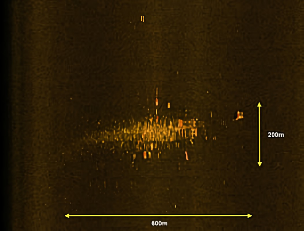
The subsea search for aircraft wreckage that many deem most similar to the search for MH370 was the search for Air France 447 (AF447), which was an Airbus A330 that crashed off the coast of Brazil in June 2009 in around 3000 m (9,800 ft) of water. Floating remnants of the aircraft were found within 2 days of the crash, but the subsea search was not successful in locating the debris field until April 2011, about 2 years after the crash. The sonar image from the debris field, which measured around 200 m x 600 m, is shown below.
AF447 is believed to have impacted the ocean surface without breaking up in flight and with a nose-up attitude. As such, the debris field that AF447 generated may be significantly different from the debris field created by the impact of MH370, as the final two BFO values suggest a high downward acceleration of 0.7g, and descent rates greater than 15,000 fpm. Without pilot intervention, MH370 possibly entered the water at a descent angle greater than 45 deg and at an airspeed approaching or exceeding Mach 1.
The debris from MH370 may more closely resemble the debris from SilkAir 185 rather than the debris from AF447. SilkAir 185 was a Boeing 737 that crashed into the Musi River near Palembang, Sumatra, Indonesia in December 1997. The aircraft experienced a rapid, nearly vertical dive that the US NTSB attributed to control inputs from the captain. During the high speed descent, parts of the control surfaces, including a large portion of the tail section, separated from the fuselage due to the high aerodynamic forces from the high speeds. The airspeed of the fuselage before impact is believed to have exceeded Mach 1.
SilkAir 185’s debris was found in two areas: the main debris field of around 60 m x 80 m at the bottom of the Musi River, which was only 8 m (26 ft) deep; and other larger debris, mainly flight control parts that separated before impact, that were widely scattered on land no closer than 700 m (2,300 ft) from the main debris field. According to the accident report, due to the high energy of the impact, the parts recovered from the river were “highly fragmented and mangled on impact” which made identification difficult.
If MH370 experienced the rapid descent suggested by the final BFO values, then it is probable that the fuselage broke apart before impact, and also probable that many large parts would be found outside of the main debris field. The flaperon recovered on Reunion Island is a good example of a flight control part that may have separated before impact. We would also expect the main debris field to be smaller in extent than for AF447, and within that debris field, the debris to be smaller and more difficult to identify. For instance, for the case of SilkAir 185, the landing gear was identified only by its subcomponents (struts, landing gear door actuators, wheels, brakes, tire pieces, etc.). This counters conventional wisdom that says that aircraft engines and landing gear should be among the easiest parts to identify by sonar on the seafloor, as it was the case for AF447.
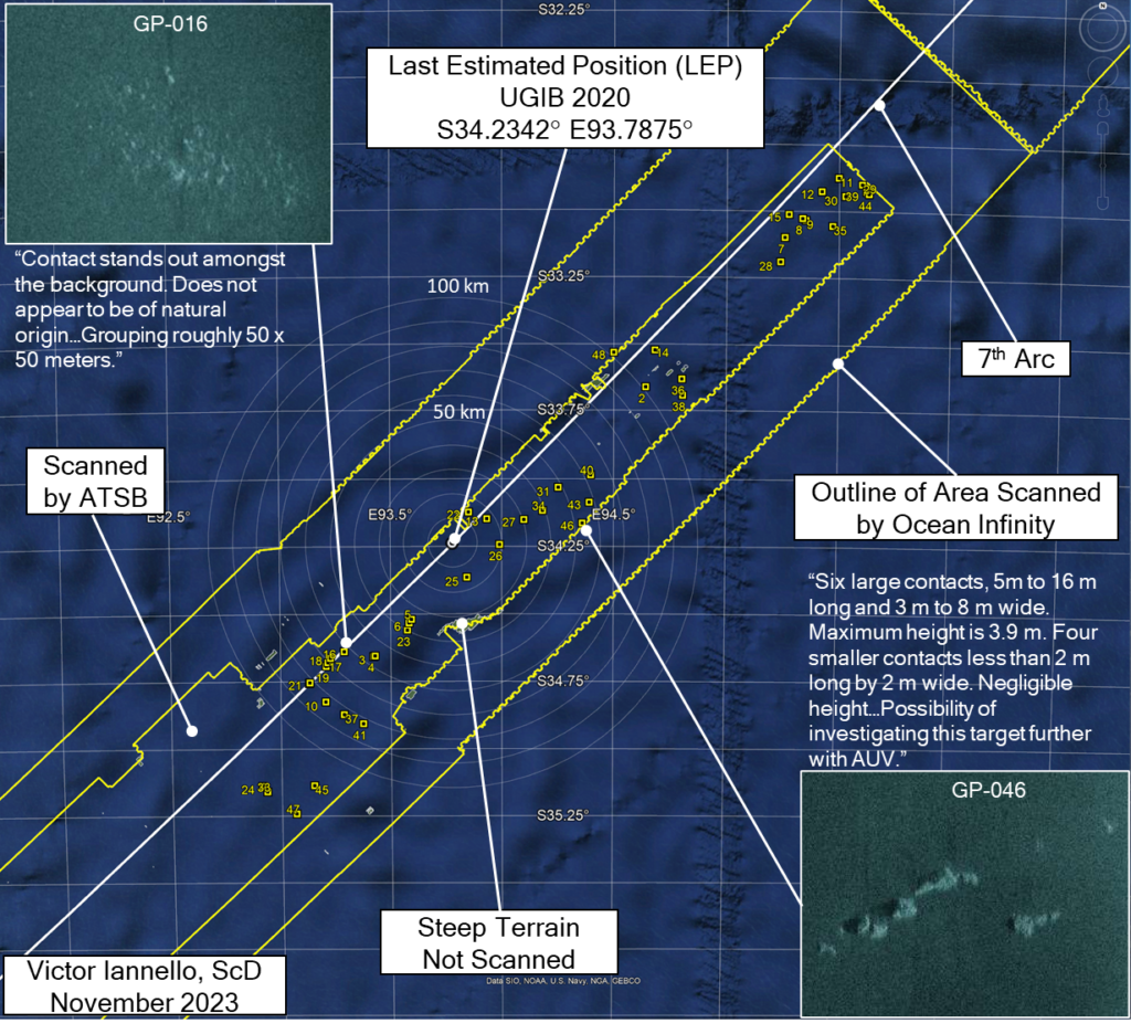
The subsea search for MH370 was focused on finding the main debris field at the expense of identifying other parts that may have separated. For the search phase conducted by GO Phoenix, reports were written for a total of 45 “contacts” (observable features in images) that merited a further review. All the contact reports are compiled here. Of these 45 contacts, 24 contacts were within 100 km of the LEP, 10 contacts were within 50 km of the LEP, and 4 contacts were less than 25 km from the LEP. The locations of the contacts are shown in the figure below.
Of the 45 contacts, 11 (GP-002, 016, 018, 019, 021, 025, 026, 028, 030, 031, 047) were described in the reports with phrases like possibly “man-made”, “not geological”, or “not of natural origin”, and one (GP-046) was considered for further investigation with an AUV, which seems to have never been done. Of course, many of the man-made objects on the seafloor could be marine debris from sea vessels unrelated to MH370.
Andy Sherrill is an experienced ocean engineer who has conducted deep water search and salvage operations for a number of missions. He was a key member of the team that reviewed the sonar data for the subsea searches for MH370 that were conducted by the ATSB and Ocean Infinity. Andy was also part of team that identified the debris field for AF447 off the coast of Brazil as well as part of the team that found Argentina’s ARA San Juan submarine. Andy graciously offered these comments as to why many of the MH370 promising contacts were never investigated further:
“Typically, if there were small isolated objects that appeared to be man-made and marked as a target, but nothing else was of interest within several kilometers then we did not investigate further.
We certainly took into account if the debris field did not look like AF447 or any others, however there still needed to be enough debris to be at least a fair amount of the aircraft to warrant further investigation.
Sure a small part of the plane could have drifted and sunk, but we were looking for the main field. A decision was made to focus on finding the main field of debris, not just one small piece – and likely all of those “potentially man made” contacts are from passing vessels given there was no associated debris within several kms.
Having said that, there is always a chance it [a tagged contact] could be from MH370, but based on our assessment the time it took to investigate each of these small contacts was not worth taking vs searching new areas.”
Discussion
As the final BFO values, the lack of IFE log-on, and the end-of-flight simulations all suggest a high speed impact close to the 7th arc, a high priority should be to completely scan the areas closest to the 7th arc. MH370’s debris field may be smaller in area, consist of smaller parts, and be much more difficult to identify than searchers were anticipating. It’s also possible that the debris field is located in an area that was not fully searched due to challenging terrain, low quality data, or equipment issues, such as the steep slope identified above as the high priority search area due south of the LEP. As such, the investigation of many of the contacts previously identified becomes more important, as one or more of these contacts could be parts of MH370 that separated before impact. It’s also possible that one or more contacts are part of a less conspicuous debris field.
We again acknowledge that with pilot inputs, it is possible that MH370 glided after fuel exhaustion beyond the areas that were previously scanned. Therefore, searching wider along the 7th arc should also be part of the search plan if pursuing areas close to the 7th arc is unsuccessful in locating any of MH370’s wreckage.
Update on Nov 3, 2023
Andy Sherrill offered these additional comments:
“We did get rerun over GP16, and collected some higher frequency AUV SSS on that one. Looks highly likely to be geologic in my opinion.
We did not reacquire any more data over GP46, however that one looks very similar to GP16 and I would still classify it as highly likely to be geologic.”
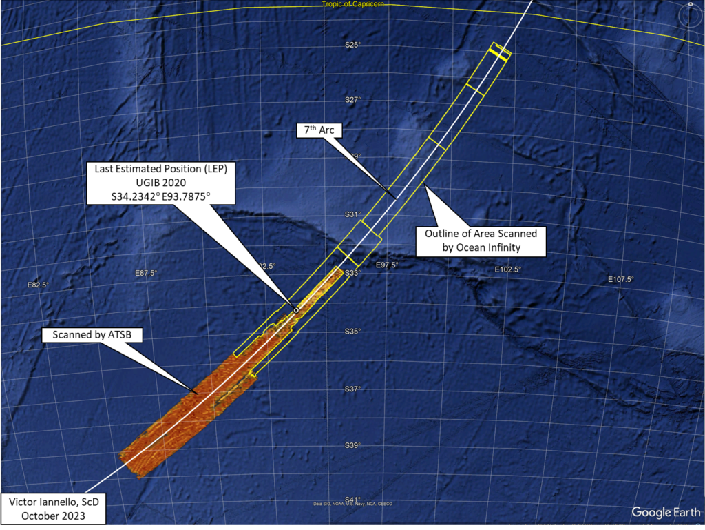
Recommended Search Areas Surrounding 34.23°S, 93.79°S
After three years of work, Bobby Ulich and I are publishing a very detailed drift model for predicting the point of impact of MH370. The most likely point of impact (POI) is estimated to be along the 7th arc at 34.0°S latitude, which is around 76 km (41 NM) northeast of the last estimated position (LEP) of 34.23°S, 93.79°E from our previous study (UGIB 2020). While the current study primarily uses drift modeling, the previous study primarily used satellite, weather, and aircraft performance data. The consistency of these two studies lends support to the results. Because of uncertainties in the drift model, the present study estimates that it is possible that debris drifted from an origin along the 7th arc between 30°S and 36°S.
The study incorporates the following data sets, assumptions, and methodologies:
Seventeen reliable MH370 debris reports with unique locations and finding dates
86,400 drift trials predicted by CSIRO using the BRAN2015 ocean model for the flaperon and for generic debris
Windage for generic MH370 debris varied over a range
A Bayesian statistic for the localization error of BRAN2015 drift tracks
Errors in the BRAN2015 ocean current and wind speeds
Minimum and maximum reporting delays of recovered debris based on barnacle encrustation
Maximum likelihood estimation theory
Processing methods for computing a PDF and estimating its uncertainty
Bayesian statistics for accommodating a large range of allowable transport speed of debris
Validation studies through non-blind, partially blind, and blind tests
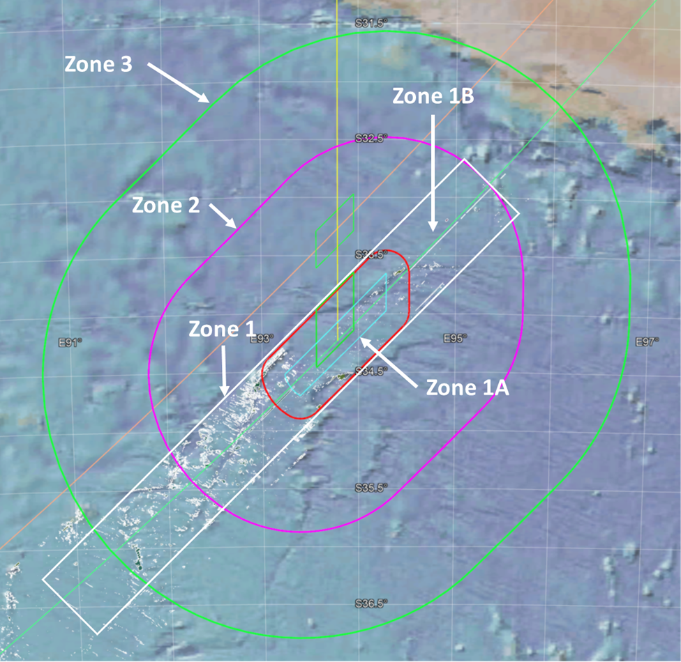
The figure above shows the subsea search recommendations from the current study. The search area is subdivided into the following zones, in order of search priority:
Zone 1: Shown as the white rectangle, the area was largely searched before, but some areas were missed due to missing or low-quality data, including areas with challenging terrain. We also consider that one or more contacts previously dismissed may be individual parts from MH370 rather than the expected field of debris. Within Zone 1 is Zone 1A, shown by the red racetrack, which defines the limits of an impact before 00:21:07, which is when a log-in to the Inflight Entertainment (IFE) server was expected. Zone 1B is the part of Zone 1 that is not within Zone 1A.
Zone 2: Shown as the purple racetrack, this area extends to +/- 70 NM from the 7th Arc, and represents the likely limits to a glide after fuel exhaustion.
Zone 3: Shown as the large green racetrack, this area extends to +/- 140 NM from the 7th arc, and represents the extreme limits of a long glide after fuel exhaustion.
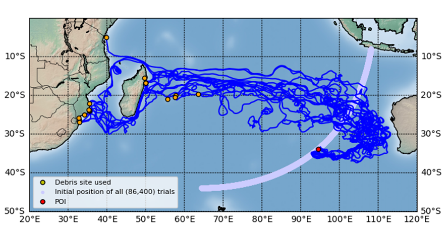
CSIRO shared with us two sets of 86,400 predicted trial drifter tracks using the ocean model BRAN2015. Each trial was assumed to have originated at a unique location near Arc 7, in an array with a fairly uniform areal density and within 25 km of Arc 7 between 8°S and 44°S latitude. The location (latitude, longitude) of each trial drifter was predicted by CSIRO at one-day intervals up to 1,027 days after crash. One set of 86,400 trials used the drift parameters CSIRO determined for the flaperon by sea trials with a cut-down flaperon. The other set was for non-flaperon debris and assumed 1.2% windage to account for Stoke’s Drift, which is shown in this video for all 86,400 trials:
Representative drift paths from our estimated point of impact (POI) to the 17 debris locations used in the analysis is shown in the following figure:
The paper “Improved Prediction of MH370 Crash Location Based on Drift Modeling of Floating Debris” by Bobby Ulich, Ph.D. and Victor Iannello, Sc.D., can be downloaded here.
Acknowledgement
I’d like to personally show my gratitude to Bobby Ulich, who has made this drift study a priority for three years, and was the driving force for its completion. We also gratefully acknowledge the many valuable contributions of David Griffin and by CSIRO, who made this work possible. In addition, we thank Don Thompson, Michael Exner, and Henrik Rydberg for reviewing an earlier version of the paper.
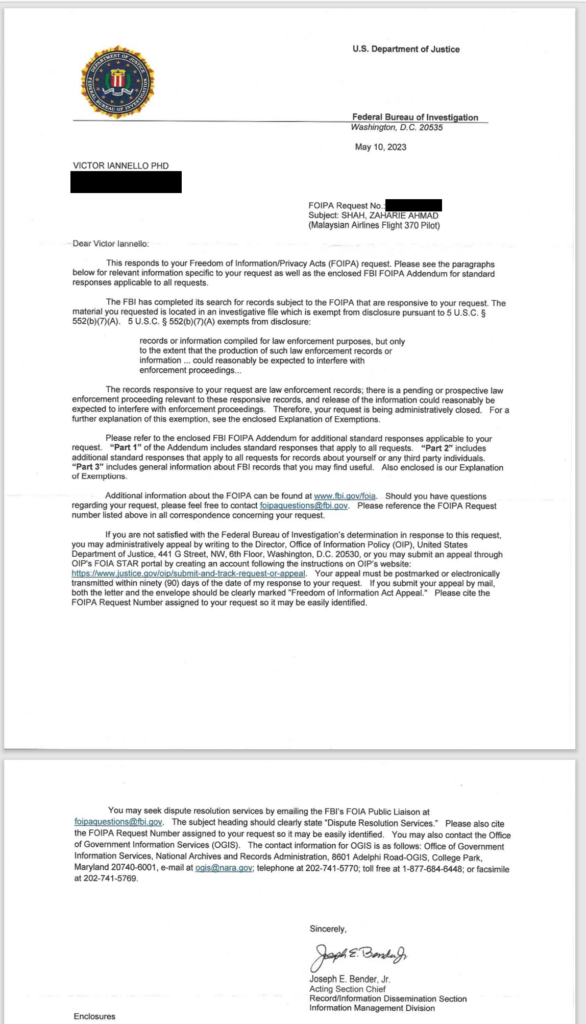
I recently submitted a FOIA request to the FBI for all documents related to MH370, which disappeared more than nine years ago. This week, the FBI responded that the request was denied due to “a pending or prospective law enforcement proceeding relevant to these responsive records, and release of the information could reasonably be expected to interfere with enforcement proceedings”. This is identical to the response I received two years ago, and two years before that, after I submitted similar requests. It implies the US intelligence community has relevant material that it will not release due to an open criminal investigation.
Although I requested “All information pertaining to Malaysia Air MH370, including but not limited to information pertaining to Captain Zaharie Shah”, the subject of the FBI’s response only referenced Captain Zaharie Shah. This could mean that only the captain is under investigation by the FBI.
In 1971, an unidentified individual that referred to himself as Dan Cooper, who later mistakenly became known as D.B. Cooper, hijacked a Northwest Airlines flight between Portland, OR, and Seattle, WA, and parachuted from the Boeing 727. That FBI investigation remained open for 45 years. With that perspective, it is possible that the facts uncovered in the FBI investigation of Captain Zaharie Shah will be unavailable to the public for a long time.
Ocean Infinity launches the first remotely-operated ship of their Armada fleet, which could be used to search for MH370
Introduction
In two previous posts, (here and here), we have presented the assumptions and analyses for reconstructing our best estimate for MH370’s path into the SIO. Often referred to as “UGIB” after its authors Bobby Ulich, Richard Godfrey, Victor Iannello, and Andrew Banks, the model was developed using exhaustive data sets and technical documentation available from both public and confidential sources, and includes:
Radar data collected by military and civilian installations in Malaysia
Timing and frequency measurements collected by the Inmarsat satellite network
Aircraft performance data for Boeing 777-200ERs
Historical performance data for airframe 9M-MRO
Navigation and speed modes for automated flight
Drift analysis of debris that floated and was recovered in East Africa
Aerial search results from March and April 2014
Weather data along the flight path
The work included the development of an accurate fuel consumption model, as well as a statistical metric for the expected random noise inherent in the recorded satellite data. These improvements allowed the rejection of hypothetical flight paths that were previously believed to be possible.
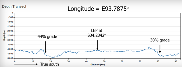
An important assumption of UGIB is that from 19:41 UTC until impact, MH370 flew with the autopilot and autothrottle engaged and with no pilot inputs. The results of that work suggest that the final hours of the flight were due south in the Indian Ocean along E93.7875° longitude, which matches a great circle between the waypoint BEDAX (about 100 NM west of Banda Aceh, Sumatra) and the South Pole. The Last Estimated Point (LEP) was defined as the intersection of E93.7875° longitude and the 7th arc, with coordinates S34.2342 E93.7875°. The debris field was postulated to be close to the LEP, as the end-of-flight after fuel exhaustion was expected to be a short distance.
The final BFO values at 00:19:29 UTC and 00:19:37 UTC suggest that MH370 was in an increasingly steep descent with a downward acceleration of around 0.7g. That, combined with the missing IFE log-on, are consistent with an impact relatively close to the 7th arc. Boeing simulations of the end-of-flight (assuming no pilot inputs) suggest an impact within 8 NM of the 7th arc. Other simulations with a PC-simulator in which a bank was imposed to match the BFO-derived downward acceleration suggest that the impact should be within 5 NM of the 7th arc. Yet, two subsea searches along the 7th arc near the latitude of 34°S, covering a much larger width of 110 km, failed to find the debris field.
The first search, conducted by GO Phoenix with a towfish, had a width of 40 km (7 km inside, 33 km outside the 7th arc) when scanning near 34°S latitude. Although this search failed, there were some areas that were missed due to terrain avoidance, shadows, equipment failures, and tracking errors, which does open the possibility that the debris field was passed over by GO Phoenix and not detected.
The second search was conducted by Ocean Infinity using a fleet of autonomous underwater vehicles (AUVs), and extended the width inside the 7th arc by 42 km and the width outside of the 7th arc by 29 km, for a cumulative search width of around 110 km (49 km inside, 61 km outside). Due to the greater maneuverability of the AUVs, the search area included some of the steep slopes that were deliberately avoided by GO Phoenix due to challenging terrain. Despite this wider and more thorough search, the debris field again was not found.
In a previous article, we postulated that the debris field may have been missed due to terrain avoidance and/or shadows, or detected but not properly interpreted by reviewers. In particular, there is a steep slope that lies about 33 km due south of the LEP and 27 km from the 7th arc that was not scanned by the GO Phoenix’s towfish and appeared to have been only partially scanned by Ocean Infinity’s AUVs.
The figure below shows the ocean depth along a line of constant longitude in the vicinity of the LEP. The previously identified steep slope to the south of the LEP has a grade of about 30%. To the north, another slope has a grade of 44%. The slope to the north was beyond the limits of the search boundaries of GO Phoenix, but was scanned by Seabed Constructor’s AUVs, so we focus on the steep slope to the south.
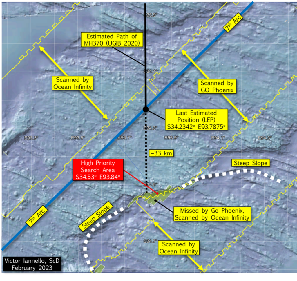
New Information about the Previous Search
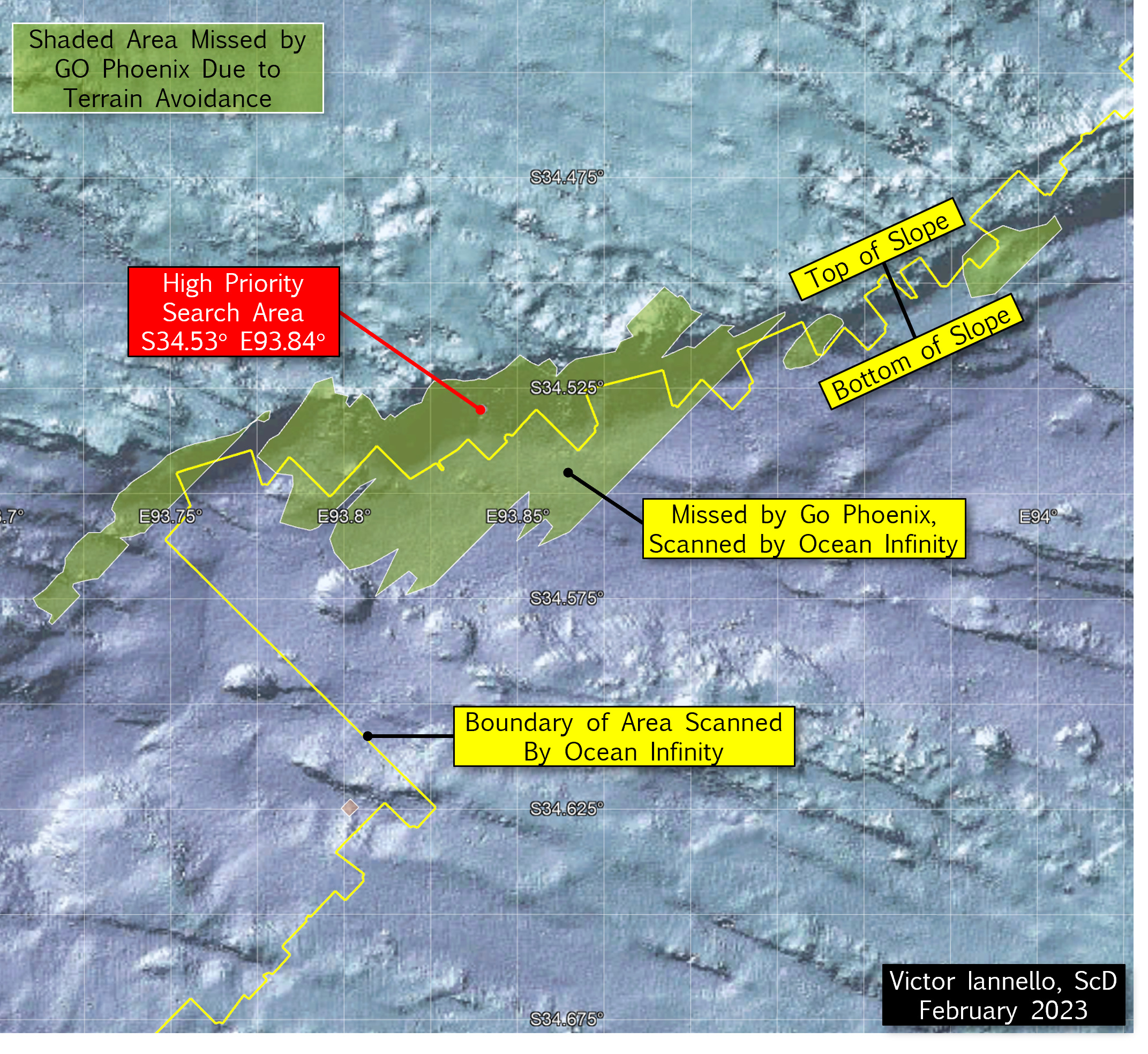
Working with Ocean Infinity, we were able to obtain a more accurate outline of the area searched with their team of AUVs. The outline is shown by the four yellow lines in the figure below. As shown in the figure, the two inner yellow lines show the approximate limits of the GO Phoenix search area, and the outer lines show the limits of the Ocean Infinity search area. Also shown in the figure are olive-green areas which represent areas that were not scanned by GO Phoenix’s towfish due to steep terrain. These and other areas of missing or low-quality data were made available by Geoscience Australia.
Looking again at the steep slope to the south of the LEP that we previously suspected was not fully scanned, we can see that our suspicions were correct. The portion of the steep slope that was not scanned by the GO Phoenix towfish is about 60.3 km2. Of this, about half was later scanned by Ocean Infinity AUVs, leaving about 30.5 km2 of seabed surrounding S34.53° E93.84° that was never scanned. We designate this area as a “High Priority Search Area”.
The figure below is a closer view of the High Priority Search Area and surrounding terrain.
(Click on image to enlarge.)
Discussion
Ocean Infinity has expressed a desire to resume the subsea search for MH370 in the Southern Indian Ocean (SIO), hopefully during the next austral summer that begins this December. As the a) final BFO values, b) the lack of IFE log-on, and c) the end-of-flight simulations all suggest an impact close to the 7th arc, a high priority should be to scan the areas closest to the 7th arc that were either never scanned or have low quality data before searching new areas further from the 7th arc. However, with pilot inputs, it is possible that MH370 glided after fuel exhaustion beyond the areas that were previously scanned. Therefore, searching wider along the 7th arc should also be part of the search plan if areas closer to the 7th arc are unsuccessful in locating the debris field.
The reconstructed route of MH370 proposed by UGIB remains a leading candidate for the hypothetical route to the SIO because of the accuracy of the physical models, the breadth of the data sets analyzed, and the statistical rigor applied to the BTO and BFO data. The analysis does assume there were no pilot inputs after 19:41 UTC, and the autopilot and autothrottle were engaged until fuel exhaustion. A steep slope to the south of where UGIB predicts MH370 crossed the 7th arc happens to lie along the extended path of the reconstructed route, and much of this slope remains unscanned. For this reason, the unscanned area surrounding S34.52 E93.84 should be designated a High Priority Search Area.
Acknowledgement
I’d like to thank Ocean Infinity for their help in defining the geographic boundary of their subsea search for MH370. I’d also like to thank Don Thompson for his help in GIS file format conversions.
According to a report released by Blaine Gibson and Richard Godfrey, another item has been recovered from a beach in Madagascar, and that part is similar in appearance and discovery location to parts that are from MH370. The new part is believed to have washed ashore in March 2017 and was discovered by a local fisherman at that time, but was unknown to the public until recently.
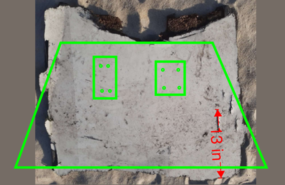
In a recent blog post that summarizes the finding of the report, Godfrey claims the debris item is likely the remnant of the left main landing gear trunnion door. In this article, we show that we can be very confident that the new debris is NOT a trunnion door.
Misidentification of the New Debris
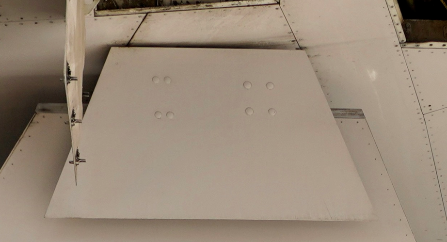
In a short technical note, MH370 Independent Group (IG) members Mike Exner, Don Thompson, Tom Kenyon, and I show why the new debris cannot be the trunnion door. To determine the approximate size of the trunnion door, we first examine a photo of the underside of a Boeing 777 in which the trunnion door can be seen. Then, using the known wing span of the B777 as a scaling reference, we can determine the approximate dimensions of the trunnion door, which are shown in the figure.
Next, we observe that the trunnion door is attached to the landing gear mechanisms by two brackets, each requiring four fasteners, as shown in this figure. That allows us to determine the position of where we would expect to see through holes through the new debris if indeed it is the trunnion door.
Finally, we compare the debris depicted in Gibson and Godfrey’s report with an outline of the trunnion door, and note that there are no through holes for fasteners in the locations expected. Nor do the dimensions of the new debris match the outline of the trunnion door.
Trunnion door outline on image from the Gibson and Godfrey report.
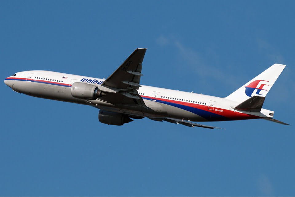
Another piece of evidence that weighs against identification as the trunnion door is the color of the paint, which is white. As Bobby Ulich says in a recent blog comment, the B777s that were operated by Malaysian Air at that time had undersides that were painted grey, not white, as seen in the next photo of 9M-MRO. Although the grey paint might have faded, other debris from MH370 that was previously recovered had identifiable paint such as livery colors and text lettering, so there is only a very small possibility that none of the grey paint would be recognizable.
Cannot Determine Landing Gear Position
There are four parallel, penetrating, narrow cuts on the new debris in which the penetrating objects appear to have entered on the interior surface of the debris and exited from the exterior, white surface. Gibson and Godfrey propose that the cuts could have been caused by rotating engine parts that separated from a disintegrating engine upon impact with the ocean. Whatever the cause of the cuts, the authors believe the damage is consistent with the main landing gear that is lowered based on the direction that the penetrating objects entered and exited the debris.
We’ve already shown that the new debris is not the trunnion door, nor is it any other part of a landing gear door, so it is not possible to surmise the position of the landing gear based on the damage to the new debris. Even if the new debris was part of one of the landing gear doors, there is no reason to believe a rotating engine part caused the damage. Components on one of the shaft assemblies in the engines would tend to fly radially outward from the engine. Yet, the landing gear doors are located aft of the engines, which are positioned forward of the wings, which means the landing gear doors are not along a projectile path. Also, when the landing gear is extended, the exterior surfaces of the doors, not the interior surfaces, are facing the engine.
Lowering the Landing Gear Does Not Increase Damage
Gibson and Godfrey propose that the landing gear might have been lowered to cause a high-speed impact designed to break up the aircraft and sink the aircraft as fast as possible to hide the evidence of the crash. However, this is not consistent with maximizing the kinetic energy of the impact, as lowering the landing gear would add drag, and could limit the attainable airspeed. After fuel exhaustion, the flight control mode would degrade from NORMAL to SECONDARY, and there would be no envelope protection that would prevent an overspeed of the aircraft. The pilot flying would only need to lower the nose by pushing forward on the yoke to ensure the aircraft would shatter upon impact.
Conclusion
The new debris recovered from Madagascar may eventually prove to have probative value. However, the debris is not part of a trunnion door from the main landing gear, nor can the debris provide any insights into the position of the landing gear when the aircraft impacted the ocean. Work continues to identify the debris and to determine any new clues about the disappearance of MH370.
Acknowledgement: This article benefited from discussions with and suggested edits from Mike Exner, Don Thompson, and Tom Kenyon.
Update 1 on February 1, 2023
Based on the construction of the composite layers, Don Thompson, Mike Exner, and other contributors to this blog believe that the new debris is more likely from the racing yacht Vestas Wind rather than from a Boeing 777. Vestas ran aground near Cargados Carajos Shoals in November 2014, and one or more pieces may have separated and floated to Madagascar.
Godfrey refutes this, and now claims that “a closer examination of the recent debris find in Madagascar proves that it is from a Boeing aircraft and cannot be from marine provenance. The key difference is the lightning protection system used on Boeing aircraft with composite materials, which is fundamentally different to the lightning protection system used in marine applications with composite materials. ” Godfrey offers this close-up photo, which he believes shows an aluminum mesh that offered lightning protection for MH370. He believes the mesh was supplied by Dexmet.
Resin infusion mesh misidentified as lightning strike protection [Godfrey comment]
Don Thompson refutes the claim that the mesh is related to lightning protection, a dubious claim that was regurgitated by Geoffrey Thomas at airlineratings.com. Don says:
The material highlighted in the photographs referred by the Gibson-Godfrey paper, and ensuing comments from the second author is not an LSP [lightning strike protection] layer; rather, it is a ‘media flow’ layer necessary on the ‘bag’ side of the composite lay-up in a resin-infusion process. That is, the resin-infusion process used by the constructor of the V065 yacht hull, its internal bulkheads and interior decks.
It’s important to understand that an LSP layer will lie immediately under the surface finish on the external face of a panel/structure as any intermediate CFRP (or GFRP) layers will form an (electrical) isolation layer.
Further, the aggregate mix surface coating that is evident in further photographs referred by the second author, and has been argued as somehow typical of B777 panels where surface protection may be necessary, is also evident on decking in video clips that document the rebuild of the seven VO65 yachts ready as they were prepared for the 2017-2018 Volvo Ocean Race. It is a common deck surface coating manufactured by Akzo Nobel/International.
Also, consider the comments from a retired, senior Boeing design engineer whose role afforded him extensive and detailed knowledge of Boeing’s composite fabrication techniques on the B777. For example: that the orientation of CFRP tape tows on the exposed side of the panel is alien to the techniques specified for the B777; that the combination of CFRP fabrication and the panel’s thickness is also alien to a B777’s construction.
The claim that this piece of flotsam originates from 9M-MRO, or any Boeing 777, is demonstrably false. Demonstrably, from the very features evident in the many images shared by the authors of the Dec 12th paper in support of their conclusion for the origin of the piece of flotsam.
The further claim that oceanographic drift studies discount this piece of flotsam originating from the Cargados Carajos Shoals in Nov-Dec 2014 before its alleged recovery from a beach near Antsiraka, Madagascar, is also demonstrably false. That assertion is false because the piece of flotsam did originate its drift, after its separation from ‘Vestas Wind’, at the Cargados Carajos Shoals on Nov 29, 2014, or within the few weeks before the yacht was salvaged and removed. How many times it beached, lay stranded, and washed out to sea again through the cycle of seasonal tides and storms is unknown, as is its final beaching and recovery time, thus rendering drift predictions irrelevant.
So, we now know that the new debris is not part of a trunnion door from the main landing gear, nor can the debris provide any insights into the position of the landing gear when the aircraft impacted the ocean. The new debris is almost certainly not from a Boeing 777, and is very likely from the Team Vestas Wind racing yacht that ran aground in the Cargados Carajos Shoals in November 2014.
Facts are stubborn things.
Update 2 on February 7, 2023
In light of the strong evidence that the new debris is from the Vestas Wind yacht that ran aground in the Cargados Carajos Shoals on November 29, 2014, I thought it would be instructive to study the path of debris that might have broken free of Vestas Wind from the accident.
To study the path of debris, I used the drift results generated by CSIRO’s David Griffin, PhD, that were created for studying how debris from MH370 drifted from hypothetical impact points along the 7th arc. In particular, I used the results of the BRAN2015 model for “generic” debris, i.e., debris that was subjected to “Stoke’s Drift”, modeled as 1.2% of the wind, but with no additional leeway drift. This is appropriate for the floating debris such as the flat panel recovered from Vestas Wind. In CSIRO’s drift simulation, 86,400 “trials” (virtual particles) were injected along the 7th arc on March 8, 2014, and the paths of these particles are tracked. Luckily, 204 of those trials passed within 100 km of the Vestas Wind accident site on November 29, 2014, so the path of those trials after that date should approximate parts of Vestas Wind that separated on that date.
In particular, I studied the timing of debris that beached on the shores of Madagascar, where a trial was classified as beached if there was negligible movement over the course of three days. Of the 204 trials, 61 trials (30%) eventually beached on the Madagascar coast. The following video shows the simulated paths of the debris originating from Vestas Wind:
(Click on the 4 arrows pointing outward to enable the full screen view.)
Based on this simulation, we make the following observations:
The first debris from Vestas Wind would reach the beaches of Madagascar in February 2015, less than 3 months from the time of the accident.
Of the debris beaching on Madagascar, more than half would arrive before May 2015, around 5 months from the time of the accident.
Very few debris would arrive after August 2015, around 9 months from the time of the accident. (The simulation ended on December 29, 2016.)
Any debris that was recovered in 2016 or later likely beached at an earlier time (likely between February and August of 2015), was swept out to sea, and then beached another time at a later date. This is likely what occurred for the new debris described by Gibson and Godfrey.
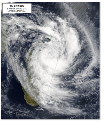
As Don Thompson noted in a private communication, tropical cyclone Enawo made landfall on Madagascar March 7, 2017, and the storm surge caused major flooding along the coast. The European Commission’s Joint Research Center published an extensive report on the storm, including the damage, as well as the number of people that were injured, missing, or died. A satellite image of the cyclone over Madagascar from that report is show below.
This tropical cyclone likely was responsible for the debris from Vestas Wind beaching on the coast of Madagascar in March 2017.