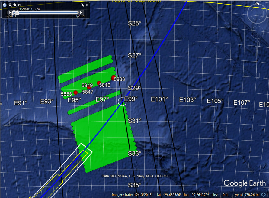
Figure 1. Location of possible debris from MH370 (red) detected during the surface search (green) on March 29, 2014. Possible flight paths aligned with waypoints also shown (black). (Click on image to enlarge.)
Introduction
Australia’s CSIRO recommends that the next subsea search for MH370 be carried out in a 25,000 sq km area that extends along the 7th arc as far north as 32.6S latitude. The recommendation is based on extensive drift analyses as well as satellite imagery which may have captured debris from the impact.
Despite the work of CSIRO, there are reasons to believe that the wreckage from MH370 is along the 7th arc, but at latitudes to the north of 32.6S latitude. Some of these reasons are:
- The absence of debris discovered along the shores of Western Australia is better explained by an impact to the north of 32.6S latitude.
- The timing and location of the fragment of the engine cowling with the letters “Roy” that was discovered in Mossel Bay, South Africa, in December 2015, is better explained for an impact north of 32.6S latitude.
- The particular impact points that CSIRO considers to be most likely are located at latitudes along the 7th arc that have already been searched to about 19 NM from the arc. With the increasing descent rates indicated by the final two BFO values, the impact likely occurred within that distance from the arc.
On the other hand, CSIRO has provided reasons why they believe the impact could NOT be north of 32.6S latitude. These are:
- For latitudes north of 32.6S, debris should have arrived in Madagascar, Mozambique, and other locations in Eastern Africa, before the discovery of debris was reported. But this could easily be explained by the delay between when debris arrived near a location, and when it is discovered and reported to authorities. In fact, the circumstances surrounding Blaine Gibson’s discovery of the horizontal stabilizer fragment with the letters “No Step” suggests the arrival of that part in Mozambique well before it was discovered.
- Reconstructed paths terminating along the 7th arc to the north of 32.6S latitude are less consistent with the satellite data. Yet, if we allow for pilot input between the last radar capture at 18:22 and the second handshake at 19:41, and if we assume automated flight after 19:41, there are reconstructed paths that match the satellite signaling data within allowable error limits. In fact, there is a range of possible paths that terminate to the north of 32.6S, and these were the focus of my last post. Within this range, there are some waypoint-derived paths that might deserve extra attention.
- If an impact had occurred north of 32.6S, the floating debris would have been detected by the surface search that was conducted by aerial surveillance in the weeks following the crash.
In this article, we take a closer look at the last item in the list.
Many believe that CSIRO’s estimate of search efficiency is over-stated, and it is possible that debris was missed during the surface search. Here, we consider the possibility that floating objects from MH370 were in fact detected by the aerial search and photographed, but those images were ignored after path reconstruction models placed the probable impact site further north, and then further south along the 7th arc. The images captured by the surface search demand a new level of attention in light of the prospect for re-starting the subsea search along the 7th arc in areas that will likely include latitudes to the north of 32.6S.
Obtaining the Images
Large areas of the ocean were surveilled by the Royal New Zealand Air Force (RNZAF) using P-3 Orion aircraft as part of the overall surface search effort. One image from March 28, 2014, which included an object described as a “blue panel”, received some attention because of the object’s resemblance to a flaperon. This object was discussed in an article by Bernard Lagan, who flew with the New Zealand Orion crew on March 28. (The video that accompanies the article is worth watching.)
Curiosity surrounding this debris prompted IG member Brian Anderson in October 2015 to request more information about this and other images collected by the RNZAF search that could be debris from MH370. His request was fulfilled, and he received a large set of images that were made publicly available on Duncan Steel’s website. For convenience, here is a compressed file (1 GB) of the all the images.
Brian continued to query the RNZAF, and was able to obtain more information about the coordinates of the images. IG member Don Thompson was also able to extract the position and timing from the meta data embedded in some of the images. IG member Richard Godfrey in turn helped assemble the data for the completed set of images and also provided some descriptions of the images. The time and position data that we have for all the images is compiled in this Excel file.
As far as we know, none of the objects identified in the surface search on March 29, 2014, were recovered by ship, so the relationship to MH370 remains unknown.
What the Images Show
The images taken on March 29, 2014, captured a variety of objects, some of which could be floating debris from the impact of MH370. The surface search also found objects that are without a doubt not from MH370, including fishing articles such as nets, floats, and marker buoys. Some of the more interesting images from March 29 are shown in Figures 2 – 5, including two debris fields of small fragments, an object that resembles a suitcase, one that resembles a portion of a panel with wires, and a rectangular box that resembled a cargo package.

Figure 2. Enlarged images of debris fields on March 29, 2014. Left: 28.3927S, 97.7750E from image 5832. Right: 29.19333S, 95.1250E from image 5853.
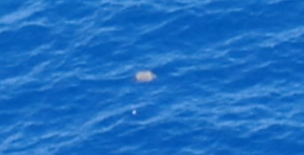
Figure 3. Object resembling a suitcase near 28.3176, 97.8234E on March 29, 2014. (Enlarged from image 5833.)

Figure 4. Object resembling a portion of a panel with wires near 28.8867S, 96.0844E on March 29, 2014. (Enlarged from image 5847.)

Figure 5. Object resembling a rectangular cargo package near 29.1936S, 95.1094E on March 29, 2014. (Enlarged from image 5854.)
Drift Analysis
As only 21 days elapsed between the impact of MH370 and the discovery of the debris, it should be possible to “backtrack” the objects to March 8 to determine a potential point of impact. To simplify this procedure, I looked at the forward drift results for a point of impact on the 7th arc at 29.7S latitude, which corresponds to the path aligned with Wilkins Runway (YWKS), Antarctica, and is also the closest path to the objects among the four waypoint-derived great circle paths that I examined in the last article.
Using the CSIRO results for drift of low windage debris from 30S latitude, I selected 31 particles that were positioned within a 15-NM radius of the assumed impact point at 29.7S latitude, among the hundreds of particles that CSIRO studied over a much larger area. The selection of multiple particles within a circular area allows for a diversity of drift paths which reflect the uncertainty in the impact point and the stochastic nature of ocean drift. Ideally, more than 31 particles would be modeled as we know the crash produced many more, but the geographic spread of the injected particles in the available CSIRO data sets limited the number of particles I could select and get meaningful results about a particular impact point. The selected particles (green) among the total particles available (translucent blue) are shown in Figure 6.

Figure 6. Selected particles (green) within a 15-NM radius (white) of the 7th arc crossing (intersection of black and blue lines) at 29.7S latitude. (Click on image to enlarge.)
The drift of the particles is shown in the following video for the time period between March 8 and March 29, 2014. The direction of the particles is from the impact at 29.7S latitude (white circle) and towards the detected debris (red dots). The video also shows how the paths of the particles diverge so that after 3 weeks, the particles are separated by more than the 150-NM distance between the two detected debris fields (images 5832 and 5853). The drift results indicate that the detected objects are consistent with an impact on March 8, 2014, along the 7th arc at 29.7S latitude. (The video is best seen in “full screen” mode by selecting the four arrows next to the Vimeo logo.)
Implications for New Search
Unless there is evidence that objects detected on March 29, 2014, are not from MH370, we have to consider the possibility that one or more objects are from MH370. This greatly increases the probability that the impact was further north than the 25,000 sq km area recommended by CSIRO for the new seabed search. Ocean Infinity seems committed to searching beyond the first 25,000 sq km, and based on the results presented here, a hot spot around 30S latitude deserves special attention.
I have asked the ATSB and CSIRO for more information about these “contacts”. The ATSB had record of the detection of some of the objects on March 29, 2014, but no record of the detection of the two debris fields. Meanwhile, David Griffin of CSIRO has agreed to do some “backtrack” drift calculations to see where along the 7th arc the debris would have originated if the debris was from MH370. As these results are very relevant to future search efforts, I will make the results available when I can.
Update on April 5, 2018
On November 29, 2017, I received an email from David Griffin in which agreed that the objects spotted by the RNZAF on March 29, 2014, could have been from an impact on the 7th arc around 29.7S latitude. At that time, I had no permission to share his email. I now have that permission, and what follows is the email in its entirety:
Hi Victor,
First, a few responses to your post (which I thought made some good points):
- The 25,000km^2 search area was not recommended by CSIRO. It came out of the First Principles Review. CSIRO was just one voice in the room.
- Roy: “better explained” – well, sort of, see below
- “could NOT be north of 32.6S” – if you check the reports I think you will find words like “less likely” are what we said.
- I won’t comment on what the images may or may not be. I leave that to others. CSIRO’s role is to comment on how floating things move.
- Your use of the kmz files: well done! I think you’ve done much of the job. See below for additional info.
- I think you have made a good point that the items seen by the RNZAF were NOT all conclusively proven NOT to be from MH370.
Next, two asides:
- The surface search targeted regions of ocean where items from the 7th arc may have drifted to. So backtracking any items seen should, by and large, conclude that they were near the 7th arc on 8 March. So anyone (one of your commenters, I think) who thinks that backtracking to the arc supports the idea that the items were MH370-related has missed the point. You are correct that the only point of doing the backtracking is to identify what area on the arc was the potential crash site.
- Forward tracking and backward tracking are mirror images when we do not include any random numbers (which is normally the case). The difference is sensitivity to starting point. Assume for the moment that the NZ photos are all bits of plane. If I backtrack them with our (guaranteed-imperfect) model, I fully expect that many would go wide of the 7th arc. Long story short: its simpler to use forward tracks, as you have done.
Finally, some fresh results:
I have now used both our models (BRAN2015 and BRAN2016, as used in our reports) to investigate the 29.7S crash site scenario. This is a “poor man’s ensemble” (just 2 members) but I think it really helps people not to over-interpret results when confronted with two models. Confucious said: “man with 2 watches does not know the time”. I say “man with just one watch thinks he knows the time exactly when he might not”.
The flow field
Trajectories from a line of points on the 7th arc (~30.5S to 29.5S on 8 March) up til 29 March:
http://www.marine.csiro.au/~griffin/MH370/br15_MH370_93103_tp3l1p2d_bh_arc7_305295_0/20140329.html
http://www.marine.csiro.au/~griffin/MH370/br16_MH370_93103_tp3l1p2d_bh_arc7_305295_0/20140329.html
It is around 19 March (click PREV to go back to then) that the line of points starts to stretch apart. You can see that this is because of the fanning-out of the sea surface height contours. 28.5S 96.5S is a saddle point in the sea level. Images 5847 and 5846 were near this saddle point. Neither model is keen to make trajectories go right there (corollary: backtracks will not come back). Wind and Stokes drift are what make it possible (in both reality and the modelling). Images west or east are more easily reached, from points on the arc that are not far apart, suggesting that it is indeed plausible (taking model imperfections into account) that all the photographed debris items were from a single origin (near 29.7 or 29.8S) on 8 March.
SST images
I have also looked at the satellite sea surface temperature imagery, and overlain this on modelled trajectories with three levels of windage. The debris will be somewhere between the 1.2% and 3% windage dots, while the deep ocean features will move more like the zero windage dots.
The images for 28 Mar
http://www.marine.csiro.au/~griffin/MH370/br15_L3S-1d_MH370_93103_tpb_arc7_305295_0/2014032812.html
and 30 Mar are clearer than 29th, and show (like others before) that there was a strong temperature front at about 29S, very close to the image locations. Currents tend to flow mostly along temperature fronts, not across them. This happens in the model as well as in the real world to a pretty good degree. But fronts are also often slightly convergent at the surface (water sinking) which is why buoyant material accumulates at fronts. So you can see that this provides a plausible explanation of why there were many debris items here – MH370-related or not.
Roy
I would not claim that BRAN2015 trans-Indian trajectories starting at 29.7S are very consistent with the finding of Roy in Dec 2015. It is only a very small fraction of the trajectories that go down there. Enough to say to it is possible – certainly – but not really a very conclusive result. See:
http://www.marine.csiro.au/~griffin/MH370/br15_MH370_IOCC_tp3l1p2dp_rw2_297986/index.html
Other items
March-April 2015 is when debris from a crash at 29.7S would (according to BRAN2015) have started to wash up on Madagascar, Tanzania and Mozambique. http://www.marine.csiro.au/~griffin/MH370/br15_MH370_IOCC_tp3l1p2dp_rw2_297986/20150312.html
Flaperon
Nov-Dec 2014 is the earliest that the flaperon might have arrived at Reunion if the crash was at 29.7S according to BRAN2015. 29 July 2015 is well after this earliest time but still perfectly plausible:
http://www.marine.csiro.au/~griffin/MH370/br15_MH370_IOCC_tp3l1p2dpf10_20_99_297986/20150729.html
So not particularly helpful.
I talked to Craig Longmuir at AMSA today about this, so have copied him in. He may have something to add about the photos and their interpretation.
So, as with the Pleiades images, these RNZAF sightings, if MH370-related, do potentially lead us to a crash site. But Pleiades and RNZAF are mutually-exclusive. Same with what was sometimes referred to as “the Esky lid”.
David