Archive for March, 2017

Possible MH370 Descent over the Andaman Sea

View of cockpit during descent. The Nicobar Islands are in the left windshield. (Click to enlarge.)

Introduction

As readers here know, we have considered the possibility that MH370 turned to the south later than 18:40 UTC and crashed along the 7th arc to the north of the seabed that was searched. What led investigators in the past to believe that MH370 turned at some point between 18:28 and 18:40 are the satellite data obtained at times that bookend this time interval. If we assume that MH370 was flying at nearly constant altitude, the BFO value at 18:28 is consistent with a plane flying at 500 knots and on a track of 296°T, which puts it parallel to airway N571 around waypoint NILAM. Similarly, the BFO value at 18:40 is consistent with a plane flying at on a track of 180°T at about 462 knots. That means a turn to the south must have occurred during this time interval if the plane was flying at constant altitude. However, the BFO values at 18:40 also match a plane descending and maintaining a northwest track, which would imply a later turn to the south. Here we consider this possibility. In particular, we consider whether:

  • The combinations of groundspeed and vertical speed required to match the BFO at 18:40 are typical of a B777 in a descent
  • The variation in the BFO values recorded at 18:40 are what we would expect if MH370 was descending

BFO Values at 18:40 UTC

A log-on sequence to Inmarsat’s satellite network occurred between 18:25 and 18:28. The BTO and BFO data obtained during the log-on suggests that MH370 was flying parallel but to the right of airway N571, near waypoint NILAM.  Commenter @Andrew, a former B777 pilot, advised us that in the event that an aircraft does not have clearance to fly an assigned airway, a 15-NM offset from the airway is recommended to avoid other traffic. It is therefore possible that MH370’s pilot, knowing that the transponder was inoperative, chose to fly at 15 NM to the right of N571 to avoid other traffic.

At the time of the call at 18:40, if MH370 was flying offset from N571, it would have been just past waypoint IGOGU in the Andaman Sea and flying towards the Nicobar Islands on a track of 294°T. The call at 18:40 produced 49 BFO values that were recorded over a period of about one minute. The values ranged between 86 Hz and 90 Hz, and averaged 88 Hz. Using this average value of 88 Hz, we can determine the values of groundspeed and vertical speed that would produce a BFO value of 88 Hz for a plane flying along a track of 294°T. Knowing the groundspeed (GS) and vertical speed (VS), the BFO is calculated from the equation

BFO(Hz) = 128.8 + 0.0372 GS(kn) + 0.0228 VS(fpm)

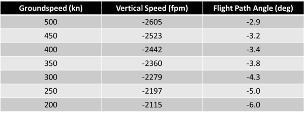
A table of selected values of groundspeed and vertical speed that result in a BFO value of 88 Hz is shown below. Also shown in the table is the calculated flight path angle (FPA), which is the negative of the descent angle, and gives some indication as to whether drag or thrust is required to maintain a particular descent rate. In general, a descent angle greater than around 3.0° will require additional drag (by deploying the spoilers, for instance), and a descent angle less than around 3.0° will require thrust from the engines. A plane gliding with a descent angle of 3.0° has a lift-to-drag ratio (L/D) of around 19. We see in the table that for groundspeed between 450 and 500 kn, the descent angle is between 2.9° and 3.2°, and the vertical speed is between -2500 and -2600 fpm. This translates to typical descent angles.

Descent Conditions to Match the BFO Values at 18:40

Automated Descent of MH370

Because the BFO varies with groundspeed and vertical speed, any variation in either of these two parameters would be represented as a variation in the BFO values that were recorded. Using the BFO equation, we find that either a ±54-knot variation in ground speed or a ±88-fpm variation would produce a ±2-Hz variation in BFO.  For an automated descent, once established, it would be rare to see a 54-knot change in groundspeed over the course of a minute. However, a 88-fpm change in vertical speed is very possible, especially for descent modes in which the elevator is used to control either Mach number (M) or indicated airspeed (IAS). For this reason, we consider that MH370 was descending in an automated mode that minimizes the variation in vertical speed. In particular, we consider a “V/S” descent in which the elevator is used to maintain the selected vertical speed and the autothrottle is used to maintain the selected airspeed, i.e., the selected value of M or IAS.

The figure below shows the calculated values of BFO for a descent in which VS=-2600 fpm is held constant and the airspeed was selected as M=0.8. The calculations assume a headwind of 3 kn, a temperature of ISA+10.8K, and a ratio of 1.06 between the geometric and pressure altitudes, which is all based on the appropriate GDAS meteorological data. The assumed descent is between FL340 to FL200, and lasts for about 5.3 min. The BFO values are calculated assuming a bias of 151 Hz, i.e., the oscillator in the SATCOM has drifted up by 1 Hz in frequency from the time it was at KLIA. This small drift allows the calculated BFO to match the measured values of BFO with a value of VS that is a multiple of 100 fpm, which is the resolution of VS that is selectable by the thumbwheel on the Mode Control Panel (MCP) of a B777. In fact, we don’t precisely know the true value of the BFO bias, but a 1-Hz drift is possible.

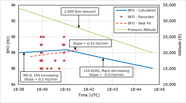
Calculated and measured BFO data during the descent at 18:40.

Also shown in the preceding figure are all 49 recorded values of BFO at 18:40. The best-fit line of the BFO data indicates a trend with a slope of 0.4 Hz/min, corresponding to a variation of ±0.2 Hz about the mean over that 1-minute interval, while the measured variation in BFO is ±2 Hz about the mean of 88 Hz. From this, we conclude that there is no discernable trend in the BFO data over this 1-minute interval, i.e., the BFO values do not appear to vary with time. The ±2 Hz variation in the BFO data is therefore treated as noise.

For the first two minutes of the calculated descent, the airspeed is held at a constant M=0.8, and the IAS increases during the descent from its initial value of 278 kn. As the outside air temperature increases during the descent, the true airspeed (TAS) increases, which causes the BFO to rise at a rate of 0.2 Hz/min. This corresponds to a variation of BFO of ±0.1 Hz over the 1-minute interval of the recorded BFO data. This variation is much smaller than the value of ±2 Hz due to BFO noise.

After about two minutes of descent at M0.8, the plane reaches a pressure altitude of 29,000 ft (FL290), and the airspeed has increased to 310 kn. At this speed, the autothrottle automatically changes modes and begins to maintain a constant airspeed of 310 KIAS during the descent. The Mach number also begins to fall. Increasing air density during the descent causes a reduction of true airspeed with a corresponding reduction in groundspeed, and the calculated BFO changes at a rate of -0.6 Hz/min. If the descent was timed so that BFO data was recorded during the descent at 310 KIAS, the variation in BFO due to the descent would be ±0.3 Hz. Although higher than the variation in BFO during a descent at M0.8, the variation is still much lower than the ±2 Hz due to BFO noise.

It should be noted that when 310 KIAS is displayed in the speed window of the MCP, this value represents the minimum airspeed during the descent at VS=-2600 fpm. If the airspeed falls below 310 KIAS, the autothrottle would increase the thrust to restore the airspeed to 310 KIAS. However, if the speed increases past 310 KIAS and the thrust is already at idle, the speed can only be maintained if the pilot adds drag by operating the speed brake lever. If the speed brake is not used, then the airspeed will increase past 310 KIAS. The net effect of this increase in airspeed will be to reduce the rate of BFO from falling at -0.6 Hz/min. Since we are concerned here with the variation of BFO during the descent, modeling the descent at a constant value of 310 KIAS provides a worst case estimate of this variation.

Conclusion

The timing of MH370’s final turn to the south has an important impact on the estimated end point along the 7th arc. The later the timing of the turn, the further north the end point is predicted to be. Although the BFO values at 18:40 UTC recorded during a 1-minute interval suggest the plane was flying at constant altitude and had already turned south, an alternative interpretation is the plane was still traveling northwest but was descending. Here, we find that the combination of groundspeed and vertical speed that is required to match the BFO at 18:40 also corresponds to a typical descent rate of around 3°. We also find that over the 1-minute interval, the change in BFO that is expected due to this descent is small compared to the noise in the BFO values that were recorded. An autopilot mode that minimizes the variation in BFO is V/S at -2600 fpm.

Posted in Aviation | 465 Comments »

MH370 Families Launch Private Search Effort

Debris map from MH370 produced by the School of Civil, Environmental and Mining Engineering & The UWA Oceans Institute

Families of MH370 passengers and crew gathered on March 4 for the Third Annual Remembrance Event of the disappearance. As part of the three-hour event, Dr Charitha Pattiaratchi, a Professor of Coastal Oceanography from the University of Western Australia, presented “The Utilisation of Ocean Drift Modeling Techniques to Locate MH370”. According to a story by aviation writer Geoffrey Thomas, Dr Pattiaratchi said that UWA’s reverse-drift modelling puts MH370 “at Longitude 96.5 E Latitude 32.5 S with a 40km radius”.  This means his estimate is at the northern end of the new search zone recommended recently by the ATSB, which was between latitudes 32S and 36S, with a total area of 25,000 sq km, and with the highest probability at 35S latitude. Dr Pattiaratchi claims that UWA’s drift model is consistent with the recovery of 18 of the 22 pieces of debris found to date.

Also as part of the Remembrance Event was the announcement that Voice370, an advocate and support group for MH370 families, launched an effort to raise money to privately search for the aircraft. In a statement recently released, the group would like to search the “newly recommended 25,000 sq km”, which presumably is the same area recommended by the ATSB. The statement is careful to not cite the group’s fundraising goal, although in a previous Reuters story , Grace Nathan, daughter of MH370 passenger Anne Daisy, pegged the number at $15 million.

This blog is dedicated towards solving the mystery of the disappearance of MH370, and I fully support continued efforts to find the plane. However, I pose a simple question: “What level of confidence do we have today that the plane will be found in the 25,000 sq km of seabed now proposed?”

Updated on March 8, 2017

A recent interview with Dr Pattiaratchi appeared in The New Daily. Here is an excerpt from that article.

[Professor Pattiaratchi]  claims the research gives authorities the “credible evidence” required to restart the search.

“That’s as good of information as you can get from an oceanography point of view.

“There is absolutely no doubt about the debris that has been found.”

The ATSB spent almost two years searching a 120,000sqkm area in the southern Indian Ocean for MH370, an area the UWA model predicted would prove fruitless.

“As soon as the flaperon (part of the aircraft’s wing) was found, we were saying it was unlikely that the plane went down in the search area at that time,” Professor Pattiaratchi said.

“The ATSB did not take into account the debris that was found. And despite the flaperon being found on [Reunion Island in] July 2015, it took them until November 2016 – almost 18 months – for them to acknowledge [MH370] is not [located] where they were searching.

It is true that the ATSB and DSTG did not incorporate drift modeling into their analyses until fairly late in the game, and Dr Pattiaratchi’s remarks are going to cause them some embarrassment. But we also have to ask ourselves:  What part of the ATSB’s analysis was incorrect?

Posted in Aviation | 687 Comments »

Radar Maybe Captured Fighter Jet Chasing MH370

Radar data from MH370 and another possible aircraft. (Click to enlarge.)

As readers here know, we have been re-visiting previously held beliefs about MH370 to better understand why the underwater search failed to find the plane. The ATSB continues to believe the assumptions that it and the DSTG used to define the current search area were correct. But if these assumptions were correct, the probability of finding the plane where it was searched was very high. Either the search team was extremely unlucky, or some of the long-held assumptions are incorrect.

It is in the spirit of questioning assumptions that I present a new possibility regarding the military radar data of MH370 above the Malacca Strait: I consider that the captures recorded by the military radar installations might be from two aircraft rather than just from MH370, as I show in the figure above. The motivation for this inquiry is the following facts that taken together cause some concern:

  1. The radar data shown in the Lido Hotel image shows an aircraft following airway N571 at a speed of around 500 kn. The last radar capture is at 18:22:12 just past waypoint MEKAR. (All times here are UTC.)
  2. If MH370 continued following N571 after the last radar capture, at the time of the log-on at 18:25:27, it would be traveling on a track of 296T.
  3. The BTO sequence during the SATCOM log-on suggests that MH370 was not following N571 at 18:25:27 through 18:28:15. However, the final BFO value suggests the plane was flying at around 296T and 500 kn, which would put it roughly parallel to N571.
  4. It is possible that the pilot performed a lateral offset manoeuver of around 12 NM between the last radar capture at 18:22:12 and the log-on request at 18:25:27. However, the manoeuver would have to be fairly well-timed to fit in that period of about three minutes.
  5. If we ignore the military radar data after around 18:02, we can find paths starting from this time that match the BTO and BFO data without the need to invoke the lateral offset manoeuver, as shown in the last post.
  6. The ATSB reports that the military radar data supplied by Malaysia concludes with a position and time at 18:01:49, and then after a 20-minute gap, there is a single capture at 18:22:12. This contradicts the many captures shown in the Lido Hotel image during this 20-minute period. The DSTG also reports that the final radar capture at 18:22:12 was not used to reconstruct possible flight paths.

To investigate this further, I considered a version of the Lido Hotel image that was studied back in May 2014 by IG member Bill Holland, and shown below. Bill enlarged the high-resolution version of the photograph, and he noticed that there were timestamps printed to the right of the targets. (The timestamps refer to local Malaysian time, which is eight hours ahead of UTC.) Although the timestamps were blurred and overlapping, using a timescale that he superimposed as a guide, he could determine what the values were for some of the timestamps. From this, he deduced that the plane’s speed was around 500 kn.

Enlarged Lido Hotel radar image with timestamps added by Bill Holland. (Click to enlarge.)

But there are features in this slide that was never explained. For one, there is a capture at 18:07:06 whose position is about 7.5 NM off of MH370’s path, and also about 2.3 minutes later than the surrounding points. Because this capture doesn’t match the path suggested by the other captures, most of us have assumed it represent a false target, and we have ignored it. Another feature is that there is an explained “hole” in the radar coverage between around 18:07:06 and 18:12:30. The Malaysian officials thought this gap in coverage was important enough to draw a white circle emphasizing it.

We can see in the figure that the radar captures that are to the west of the “hole” lie along airway N571 between waypoints VAMPI and MEKAR. We also see that these captures align with the unexplained capture at 18:07:06, suggesting this may represent the path of a second aircraft.

We can also see that the paths of the two aircraft cross in the “hole”. Perhaps the gap in radar coverage is due to the radar’s inability to distinguish and positively identify each target due to proximity. The intersection of paths occurs near the center of this circle, although the aircraft would pass this intersection point at different times.

There are some other interesting aspects of this hypothesis about two aircraft captured by radar. The path of MH370 that is shown in the figure corresponds to a track of about 296T, which is roughly parallel to N571 after MEKAR, yet with an offset to the right from N571 that produces a good match with both the BTO and the BFO data at about 495 kn. So, this theory allows us to match the BFO and BTO data without invoking a precisely timed lateral offset manoeuver. MH370’s path is already spaced to the right of N571.

Another interesting aspect occurs when we extrapolate the path of the second aircraft backwards in time. Doing so, we find that the path crosses a point just to the south of Runway 18 of Butterworth Air Field near Penang. This raises the possibility that the second aircraft departed from from Butterworth and chased MH370.  Richard Godfrey discovered that this point to the south of Butterworth falls very close to waypoint UPTOP.

 We can estimate the speed of the second aircraft by considering the timing and positions of the radar captures that have timestamps of 18:07:06 and 18:13:30, which correspond to the unexplained radar point to the east of the “hole” and another capture after waypoint VAMPI to the west of the “hole”. The distance is about 77 NM, which would mean the second aircraft was flying with a groundspeed of about 722 kn. Assuming a temperature offset from standard conditions of about 14K, this corresponds to Mach 1.07 at sea-level, and Mach 1.21 at FL350. This tells us the second aircraft was not a civilian aircraft. The speeds, although fast, are certainly within the speed capability of modern military fighter jets, including one of the Boeing F/A-18D Hornets based at Butterworth Air Field.

We can also use the timestamps of the targets to the west of the “hole” to determine that the groundspeed of the second aircraft was around 500 kn after it caught MH370. This suggests that the two plane were flying roughly side-by-side, albeit with an estimated lateral separation of about 18 NM.

If this hypothesis considered here is true, it would answer some important questions about the radar data. But it would also raise even more questions about how Malaysia responded to MH370 after it disappeared from civilian radar screens and flew back across the Malay peninsula and above the Malacca Strait. If the theory is correct, it also would raise important questions about why Malaysia chose to keep this high-speed chase a secret.

Posted in Aviation | 169 Comments »