After three years of work, Bobby Ulich and I are publishing a very detailed drift model for predicting the point of impact of MH370. The most likely point of impact (POI) is estimated to be along the 7th arc at 34.0°S latitude, which is around 76 km (41 NM) northeast of the last estimated position (LEP) of 34.23°S, 93.79°E from our previous study (UGIB 2020). While the current study primarily uses drift modeling, the previous study primarily used satellite, weather, and aircraft performance data. The consistency of these two studies lends support to the results. Because of uncertainties in the drift model, the present study estimates that it is possible that debris drifted from an origin along the 7th arc between 30°S and 36°S.
The study incorporates the following data sets, assumptions, and methodologies:
- Seventeen reliable MH370 debris reports with unique locations and finding dates
- 86,400 drift trials predicted by CSIRO using the BRAN2015 ocean model for the flaperon and for generic debris
- Windage for generic MH370 debris varied over a range
- A Bayesian statistic for the localization error of BRAN2015 drift tracks
- Errors in the BRAN2015 ocean current and wind speeds
- Minimum and maximum reporting delays of recovered debris based on barnacle encrustation
- Maximum likelihood estimation theory
- Processing methods for computing a PDF and estimating its uncertainty
- Bayesian statistics for accommodating a large range of allowable transport speed of debris
- Validation studies through non-blind, partially blind, and blind tests
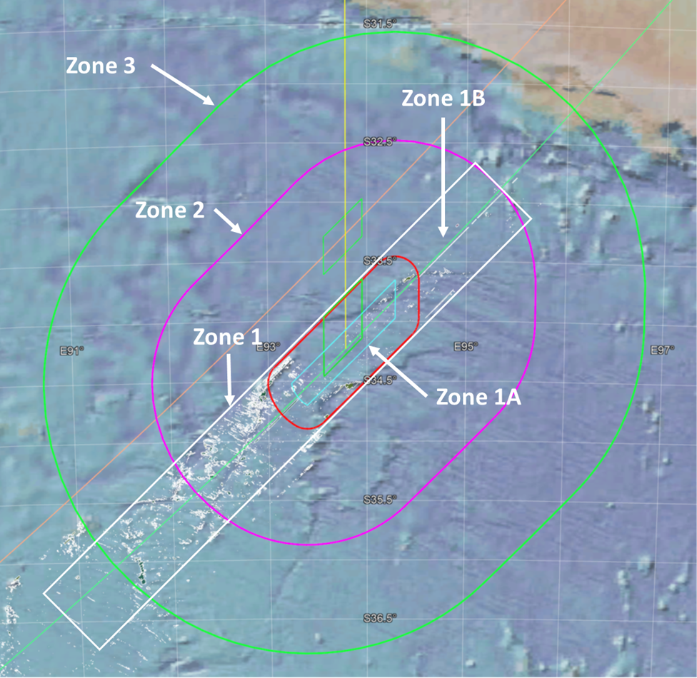
The figure above shows the subsea search recommendations from the current study. The search area is subdivided into the following zones, in order of search priority:
Zone 1: Shown as the white rectangle, the area was largely searched before, but some areas were missed due to missing or low-quality data, including areas with challenging terrain. We also consider that one or more contacts previously dismissed may be individual parts from MH370 rather than the expected field of debris. Within Zone 1 is Zone 1A, shown by the red racetrack, which defines the limits of an impact before 00:21:07, which is when a log-in to the Inflight Entertainment (IFE) server was expected. Zone 1B is the part of Zone 1 that is not within Zone 1A.
Zone 2: Shown as the purple racetrack, this area extends to +/- 70 NM from the 7th Arc, and represents the likely limits to a glide after fuel exhaustion.
Zone 3: Shown as the large green racetrack, this area extends to +/- 140 NM from the 7th arc, and represents the extreme limits of a long glide after fuel exhaustion.
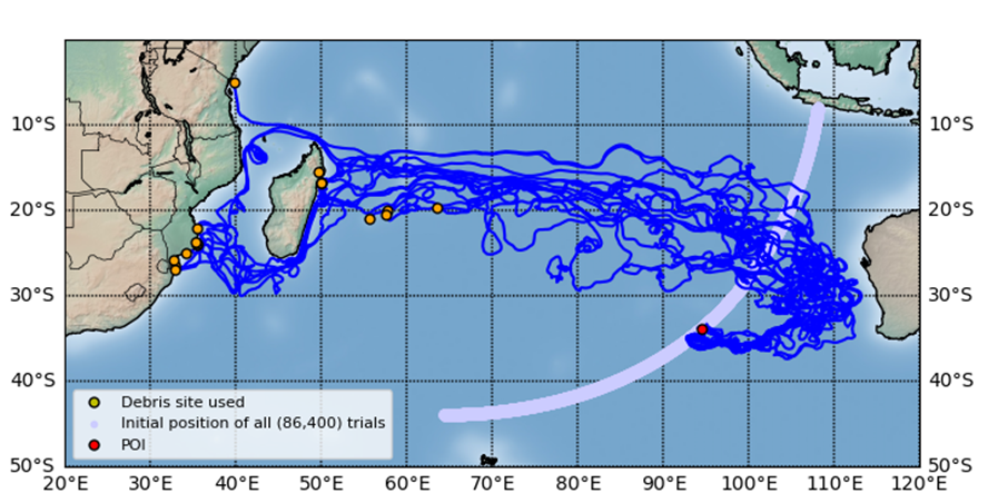
CSIRO shared with us two sets of 86,400 predicted trial drifter tracks using the ocean model BRAN2015. Each trial was assumed to have originated at a unique location near Arc 7, in an array with a fairly uniform areal density and within 25 km of Arc 7 between 8°S and 44°S latitude. The location (latitude, longitude) of each trial drifter was predicted by CSIRO at one-day intervals up to 1,027 days after crash. One set of 86,400 trials used the drift parameters CSIRO determined for the flaperon by sea trials with a cut-down flaperon. The other set was for non-flaperon debris and assumed 1.2% windage to account for Stoke’s Drift, which is shown in this video for all 86,400 trials:
Representative drift paths from our estimated point of impact (POI) to the 17 debris locations used in the analysis is shown in the following figure:
The paper “Improved Prediction of MH370 Crash Location Based on Drift Modeling of Floating Debris” by Bobby Ulich, Ph.D. and Victor Iannello, Sc.D., can be downloaded here.
Acknowledgement
I’d like to personally show my gratitude to Bobby Ulich, who has made this drift study a priority for three years, and was the driving force for its completion. We also gratefully acknowledge the many valuable contributions of David Griffin and by CSIRO, who made this work possible. In addition, we thank Don Thompson, Michael Exner, and Henrik Rydberg for reviewing an earlier version of the paper.
Great work Victor with all your expertise and dedication as a team along with Mike, Don and David Griffin, I support your efforts to finally put this mystery to rest once we uncover the crash site and everyone will be thanking you and the others of the independent group.
Thank you, Mike R.
@Victor
Amazing work in trying to find MH370. It is inspiring and hopeful for the NOK and for us who have been intrigued (and alarmed) as to how a commercial flight could just disappear.
Against all the odds (secrecy from some quarters), you are persevering in your quest to locate the aircraft.
Well done @Victor @ Bobby @Don @Mike @David @CSIRO and @Henrik
Shouldn’t the difference between Zones 1A and 1B be in the direction perpendicular to the 7th arc, not parallel as it’s now? Both 1A and 1B have (almost) the same length in the perpendicular direction (distance from the 7th arc), so what is the length of 1B in this direction based on if not the 00:21:07 time limit? 1A is more restricted in the parallel dimension than 1B, but isn’t that a matter of where the 7th arc crossing point is rather than the 00:21:07 time limit?
@eukaryote: Zone 1 was mostly searched before. Within that, Zone 1A has the additional constraint of an impact before 00:21:07, which was defined as the highest priority area. Zone 1B is the remainder of Zone 1.
It’s a good concept to separate the 00:21:07 area, and if Zone 1 was more like UGIB A1 (as shown in Figure 16.1-1 p.50), it would make sense to me. But it looks like both 1A and 1B (or Zone 1) have the same distance from the 7th arc (00:21:07 limit), while Zone 1 simply has a wider range of possible 7th arc crossing points than 1A. Anyway, thank you for providing another extensive analysis.
@eukaryote: How the overall search area gets subdivided and the priorities assigned is of course subjective. Basically, the areas closest to the 7th arc get the highest priority because of the indicators of a short flight after the last log-on request. Those indicators include the 0.7 downward acceleration derived from the final BFO values, and the missing IFE log-on. Then, move outwards from the 7th arc, limited by the maximum possible glide distance.
@Victor Iannello:
I don’t disagree with the prioritization, my confusion is about the implementation of those priorities in the specific zones shown. As I see it, 1A is not a subset of Zone 1 based on the 00:21:07 limitation, but a subset of Zone 1 based on restricting the range of crossing point latitudes close to BEDAX as opposed to the wider 33S-36.5S range (and both have the 00:21:07 limitation, otherwise Zone 1/1B should extend further away from the 7th arc).
I don’t understand how 1A could be derived from Zone 1 (white and red in Figure 17.1-1) by implementing the 00:21:07 limitation, while I would understand it for 1A and UGIB A1 (orange and red in Figure 16.1-1).
TBill wrote:
Does this rule out a hypoxia scenario for MH370 on technical grounds ?
@Victor Iannello
Good post (as we have come to expect…you never disappoint)
What are the white dots in the lead graphic? Data holidays?
@Peter Norton: It looks like there were manual inputs as MH370 rounded Penang Island and then intercepted N571 at VAMPI, so if hypoxia occurred, it was after Penang.
@Peter Norton
Yes for MH370, hypoxia as the crash cause is less popular among flight path modelers, because the *apparent* straight flight path cannot be convincingly explained for accidental reasons.
An accidental hypoxia MH370 flight would be magnetic/curved flight path, assuming we properly understand how a B777 works upon waypoint discontinuity.
Going back to about 2017, we did not know about the magnetic curved default for a B777. Back then, many felt a straight path could be hypoxic. Andrew Banks was one of those who helped confirm the magnetic heading in commercial sim studies, whereas this topic was an early focus of this (Victor’s) blog.
This finding has probably caused some of the public controversy we see today. Investigators (such as perhaps DrB) have changed and adopted the intentional passive flight concept to a waypoint such as South Pole. Others, who favor the accident explanation, have had to say the radar/Inmarsat data must therefore be wrong because the data does not support their beliefs.
We currently only have one MH370 flight path proposer (that I am aware of) who (changed from straight path to) now claims a magnetic overflight (curved) path due to accidental hypoxia. But I suspect it is weak technical case.
Of course, those of us who believe active pilot are not included in the above history. In that case, an *apparent* straight path can a curved path that slowed down after Arc5, for example.
@George Tilton: The shaded areas represent data holidays due to equipment failures, low probability of detection, offtrack towing, shadows, and terrain avoidance.
@Peter Norton,
I don’t think there is enough convincing evidence that it flew along N571, or in straight lines up the Straits.
Therefore, I think it could be a hypoxic flight ghost flight, starting shortly after the IGARI turn.
The meandering flight explained by flight controls degraded to ‘secondary’ and the autopilot off, all due to technical issues.
@Tim: The civilian and radar data show straight flight with several well-defined turns, including intercepting a leg to VAMPI and joining N571. There were pilot inputs to achieve this.
https://mh370.radiantphysics.com/2019/01/12/mh370-flight-around-penang/
From the New Straits Times:
Transport Minister Anthony Loke said if there is new credible evidence, the government would first hold discussions with China and Australia on the possibility of resuming the search for the plane.
“The goal of finding MH370 will not be ignored.
“But the ministry does not have new credible evidence to resume the search for MH370.”
https://www.nst.com.my/news/nation/2023/06/920563/loke-mh370-search-may-restart-if-there-new-lead
@Victor
That does not sound good. That sounds a bit less promising than Loke’s prior comments.
@TBill: They can set the bar for “new credible evidence” as high or low as they want, depending on whether or not it is their sincere intention to support a new search.
I have never understood this ridiculous statement about “new credible evidence” …
They don’t pay anyway if OI searches on a no-find-no-fee basis.
So either MH370 is not found and Malaysia doesn’t pay.
Or OI finds MH370 which certainly counts as “new credible evidence”.
Therefore it seems hypocritical and nonsensical of the Malaysian government to ask for “new credible evidence” prior to agreeing to a no-find-no-fee agreement. This screams: “We don’t want to find the plane!”
No ?
Sorry, but this makes me angry.
@Tim (or anybody else): Despite passive stabilizing characteristics from dihedral and sweep, are you aware of any aircraft that has flown for long distances with no pilot inputs, without the autopilot engaged, and without flight control augmentation such as the NORMAL flight control mode?
@Peter Norton: It might not be that Malaysia doesn’t want to find the plane. Rather, they might not want to conduct another search, with the associated costs for supporting OI and the raised expectations, that ends in failure.
Victor Iannello: “It looks like there were manual inputs as MH370 rounded Penang Island and then intercepted N571 at VAMPI, so if hypoxia occurred, it was after Penang.”
Confused manual inputs by a hypoxic pilot … isn’t this a possibility ?
Victor Iannello: “with the associated costs for supporting OI”
… born entirely by OI due to the no-find-no-fee agreement, no ?
Do you really think, the Malaysian government is so altruistic that they don’t agree to the OI search, because they are so altruistic and concerned about this private company’s financial loss? Or am I misunderstanding what you say?
(I get your other part about another failure, although this also would be OI’s failure primarily, so same question to you.)
@Peter Norton: Even with the no fee arrangement, there would be costs borne by Malaysia if the search was supported like the last search by OI. The search area would have to be defined, negotiated, and approved, there would be Malaysians assigned to monitoring operations and managing the project, and there would be reports generated for public consumption.
@Peter Norton: In the confused pilot scenario, the confusion would have begun at the time of the diversion as no attempt was made to descend and prepare for a landing at Penang or anywhere else. The confusion would have continued after rounding Penang, when the leg to VAMPI was activated. That’s a very long time for hypoxia without complete incapacitation. Some have proposed what I call “tag team” hypoxia, where various crew members provide inputs, are incapacitated, and then others begin providing inputs until they, too, succumb.
Of course, there is still the extraordinary coincidence of the captain’s simulator data which shows a simulated flight in the weeks before the disappearance that ends with fuel exhaustion in the SIO.
@Bobby and @Victor. Thank you for this latest opus with characteristic rigour. A question on the TSCF since this is a proxy sensitivity analysis for uncertainty around “windage”(wind-attributed forcing, inclusive of Stokes drift). If I understand correctly, the TSCF method essentially adjusts the “playback speed” on a trial but does not affect the detailed trajectory or ultimate path.
In practice, a change in balance of the current and wind forcing will affect both net speed and direction. In a body of water full of eddies, an object with zero leeway will spend a great deal of time meandering through those eddies. On the other hand, a particle with high wind factor would scoot across the same eddies if the wind direction is fairly consistent. It is self-evident that the impact on trajectory and net velocity will be greater than a commensurate change in simulation “play speed” as long as there is more perturbation in OSC than in wind. The sensitivity of model result to “leeway” will be substantial because the relative balance of wind/current forcing changes markedly across a plausible range of leeway assumptions, with wind-forcing becoming dominant (in this space and time) at the upper end.
A separate consideration, not covered by the sensitivity analysis for non-flaperon items, is offset of wind forcing to wind direction. The phenomenon will well documented and is expected to range from 0-40 degrees left of wind in the southern hemisphere for items floating in the uppermost layer. Without ascribing a specific value to this offset angle, the generic effect (compared to zero angular offset) would be to “tighten the loop” of the first third of the drift passage, reducing distance travelled while also reducing likelihood that debris from more southern POIs would encounter the Australian littoral.
For these reasons – and with due appreciation of the effort to test sensitivity to leeway uncertainty – it is my contention that the TSCF method employed doesn’t faithfully model uncertainties in the wind factor.
@Victor Iannello
> “The search area would have to be defined, negotiated, and approved”
Why does OI need negotiation/approval of the search area in international waters??
Just from a legal standpoint, aren’t they free to search wherever they want ?
If Malaysia pays for the search, then yes, they can dictate the location. But since they don’t pay anyway, on what grounds can they claim any legitimacy for imposing any search terms on a a search in international waters they don’t pay for ?
It’s not conclusive to me.
> “there would be Malaysians assigned to monitoring operations and managing the project, and there would be reports generated for public consumption.”
Wouldn’t this be a negligible amount (at least compared to payrolling the search) ?
> RE: “tag team” hypoxia
What if most on board became hypoxic, including the pilots, and a flight attendant with portable oxygen entered the cockpit, but was unable to navigate/communicate – hence the incomprehensible flight path and lack of communication. Isn’t that what happened on Helios 522 ?
From Wiki: « They intercepted the passenger jet at 11:24, and observed that the first officer was slumped motionless at the controls, and the captain’s seat was empty. They also reported that oxygen masks were dangling in the passenger cabin. At 11:49, flight attendant Andreas Prodromou entered the cockpit and sat down in the captain’s seat, having remained conscious by using a portable oxygen supply. His girlfriend and fellow flight attendant, Haris Charalambous, was also seen in the cockpit helping Prodromou try to control the aircraft.[10] Prodromou held a UK Commercial Pilot Licence, but was not qualified to fly the Boeing 737. Prodromou waved at the F-16s very briefly, but almost as soon as he entered the cockpit, the left engine flamed out due to fuel exhaustion, and the plane left the holding pattern and started to descend. Crash investigators concluded that Prodromou’s experience was insufficient for him to be able to gain control of the aircraft under the circumstances. However, Prodromou succeeded in banking the plane away from Athens and towards a rural area as the engines flamed out, with his actions meaning that there were no ground casualties. Ten minutes after the loss of power from the left engine, the right engine also flamed out, and just before 12:04, the aircraft crashed into hills near Grammatiko »
Of course this doesn’t explain what happened with the SDU (unless these were side-effects of the flight attendant trying to somehow handle the plane, unlikely as it seems?).
@Peter Norton asked:
Why does OI need negotiation/approval of the search area in international waters?? No approval is necessary for searching. We were discussing Malaysia’s reluctance.
Wouldn’t this be a negligible amount (at least compared to payrolling the search) ? This would be a small sum compared to the costs borne by OI. But the costs and diversion of resources is not zero.
What if most on board became hypoxic, including the pilots, and a flight attendant with portable oxygen entered the cockpit, but was unable to navigate/communicate – hence the incomprehensible flight path and lack of communication. Isn’t that what happened on Helios 522 ? Yes, some have proposed scenarios like this. However, I don’t think the cabin crew would be entering waypoints associated with jetway intersections into the FMS.
And there’s also the matter of the simulator data on the captain’s computer.
@Victor Iannello: “No approval is necessary for searching.
Hm? You previously said: “The search area would have to be defined, negotiated, and approved”
I am sorry, I am not trying to argue, but I honestly don’t understand what could motivate Malaysia’s reluctance if they really want to find the plane. I don’t buy that it’s about this “small sum” of money. And the failure of not finding the plane would be OI’s. Worse, if Malaysia doesn’t even agree to a no-find-no-fee search, it will be seen as a failure on Malaysia’s part (including the negative media coverage on the 10th anniversary) AND Malaysia will also be seen as a spoiler for having thwarted a search free-of-charge to them. It’s very bad PR.
One possibility for not wanting the truth to come out, would be if the truth were even worse PR.
I am open to any other plausible explanation, but I have yet to see one.
@Peter Norton
Aside from conspiracy theories, it might be the case that MH370 was simply a deeply shameful episode for the Malaysian Government and, by extension, Malaysia as a nation. Shame and humiliation are not worn lightly in Asian collectivist cultures and it’s possible the Malaysians simply want to move on. A new search will yet again bring the tragedy to the forefront of everyone’s minds and possibly raise false hopes. That’s not something the Malaysians are likely to countenance without “new credible evidence”, whatever that might be.
@Victor
Surely it is in the global aviation’s interests to find MH370. The world’s flying public and aircraft manufacturers, inter alia, need to know what caused the plane to disappear.
So searches should be funded jointly by say America and Europe. Australia and China!
Malaysia is fixated on credible evidence for reasons we all know about but other countries have altruistic, moral and airline safety motives for funding a search or several searches until the plane is found.
Thanks for the new work.
So if the most likely impact site from this study is 76km from the LEP from your last study… Which one would you recommend searching first?
(I realise 76km is not a huge distance given the area involved, but it’s also not nothing. Interested which study you have most confidence in!)
@Julia Farrington
I wish I could find the old newspaper article, but one journalist commented long ago that this accident does not make anyone look good. Malaysia is not the only one hoping to sweep this one under the rug.
IMHO, in all likelihood we are talking about air piracy for MH370, which dampens interest in finding the aircraft. But that is probably not the correct answer. That is maybe even more reason to find it, except that’s not how the public sees it. Public perception (of risk) is terrified about hidden mechanical flaws, and complacent about air piracy. But according to Wikipedia Suicide by Pilot is now #2 cause of fatalities, and I’d say probably #1 if they counted MH370, ChinaEastern etc. The public is tuned out on it.
@TBill
Thank you. Interesting observations.
@Paul Smithson,
Your understanding of the “Transit Speed Correction Factor” we employed in Method III is generally correct.
The justification for attempting to compensate for the fact that the windage is not known for every debris is given in Section 8.1:
“Even the improved Method II fails to produce an accurate probability curve when the drift parameters of a given debris (such as windage and leeway angle) are not accurately known and used in the ocean drift model. Previous drift predictions did not allow for the fact that the drift parameters are only known for two of the debris [the right flaperon and “Roy”, whose drift characteristics were empirically determined by CSIRO in sea trials; see Griffin et al. (2016)]. Therefore, if the windage, for example, of a particular debris is different from the value assumed in the ocean drift model, errors will certainly occur in the predicted arriving dates, thereby producing errors in the POI probability curve for that debris. Large windage errors can shift the probability peak by at least several degrees of POI latitude. Therefore, it is necessary to (a) use only debris whose drift speeds and directions have been characterized, or (b) use a prediction method which can compensate for this lack of knowledge, at least for debris with near-zero leeway angles. We followed option (a) for the flaperon and option (b) for the non-flaperon debris we analysed.”
In Section 8.4 we said the method we used (effectively changing the “playback speed” of the predicted drift tracks) was a crude approximation but was the only one available to us:
“In a new Method III, we allow the TSCF to vary for each debris and for each assumed POI latitude, if needed. Making only transit speed adjustments assumes the leeway angle is close to zero, as CSIRO assumed for their generic drift track predictions. In addition, we assume the drift track is unchanged in location, and only the time axis is adjusted. Clearly this is a crude approximation, but it is a necessary one because we have only two sets of CSIRO tracks to process (for the assumed flaperon and non-flaperon drift parameters).”
First, we only used a different TSCF if that was necessary to put the predicted arriving date within the range determined by the reporting date and the degree of barnacle encrustation. In most cases this was unnecessary. Out of seventeen debris we analyzed, only four resulted in non-zero TSCFs.
Second, and more importantly, in all non-flaperon cases we included a significant contribution in our error budget for the windage varying from 0.8% to 2.0%. So, our error bars on the predicted latitudes allow for windage uncertainty within this range (independently of whether or not the TSCF was fitted), as well as for the large uncertainties in the reporting delays for debris with no barnacle encrustation when found. The TSCF was intended to identify any cases where the drift speed was outside that assumed windage range.
From Section 8.9:
“By studying the fitted TSCF values in Method III, we found that, while the average transit speed was important in discriminating POI latitude, it was generally not dominant. A comparable degree of discrimination is provided by the proximity of the predicted tracks of trial drifters to the finding locations. Thus, both spatial and temporal discriminations are significant, and their relative strengths depend on both the assumed POI latitude and on the debris finding location.”
The bottom line is that including or excluding those four cases for which the debris drift speed might be inconsistent with the assumed drift parameters had very little effect on our predicted Joint PDF of crash latitude.
@vodkaferret asked: So if the most likely impact site from this study is 76km from the LEP from your last study… Which one would you recommend searching first?
The UGIB method is much more accurate, but it relies on some key assumptions, e.g., automated flight with no pilot inputs after 19:41. The present study makes no assumption about how the plane arrived at the 7th arc, but the possible range of impact sites stretches from 30°S and 36°S.
The search area recommended above is centered on UGIB, but also incorporates the results from the drift study to help define the broader area to search. We would prioritize the search areas as 1A, 1B, 2, and then 3.
@Peter Norton said: One possibility for not wanting the truth to come out, would be if the truth were even worse PR.
I may be naive, but I do think Malaysia wants to find the plane, even if it discloses some embarrassing facts (which they may attempt to hide or spin). But I think Malaysia doesn’t want the negative publicity associated with committing to a new search, raising expectations, and failing again.
@vodkaferret,
Speaking for myself, all of the inadequately searched areas within Zone 1A are the highest priority for a new search.
Victor has previously recommended S34.53, E93.84:
https://mh370.radiantphysics.com/2023/02/11/a-high-priority-area-to-search-for-mh370/
I concur this spot is a good guess. It’s difficult terrain that has not been imaged, it is well within the 00:21:07 Zone, and it is very close to the LEP. If I could look at only one spot, that would my choice.
Yes, I agree that the steep slope around S34.53, E93.84 should be the highest priority area within the zone 1A.
There are also a number of contacts from the GO Phoenix search that were classified as probably manmade but were not further investigated. We have to remember that the searchers were primarily looking for a debris field. As such, contacts that were believed to be individual manmade objects were passed over in favor of continuing the search for a debris field. In retrospect, finding even a single part from MH370 would be extremely valuable, as the search for the debris field could be greatly focused in the vicinity of the part(s).
Megyn Kelly interviewed William Langewiesche (the author of a respected article on MH370 that appeared in The Atlantic). Megyn has millions of followers.
https://youtu.be/v_y0A2cheo4
> @Victor Iannello: « I do think Malaysia wants to find the plane »
If someone says: “Hey Malysia, I am looking for your plane with the best equipment in the world and I’ll pay the full costs if I don’t find it, so you bear no risk!” …
… and Malysisa answers: “No! You must show evidence, otherwise we don’t let you do unpaid work for us.”
… then I really don’t think, they want to find the plane. It seems obvious.
Someone should ask the Malaysian government, what they would accept as “new, credible evidence” at this stage!
They know perfectly well that absent a seabed find (which they prevent by counteracting the underwater search), it is virtually impossible for new, game-changing evidence to surface 9 years later.
Although one could argue that the many pieces of debris and – based upon them – the drift study posted above DO qualify as “new credible evidence”“!!
If the Malaysian government doesn’t accept this evidence, then what kind of evidence are they going to accept? Hasn’t any good journalist confronted them with this question? They basically reject all evidence at hand short of the plane magically resurfacing by itself …
If OI succeeds in locating the debris field:
• Who will search for the black boxes?
• And who will take the black boxes into custody and examine them? Malaysia?
Here an interesting side-note. Let us recall that the last 2 ADS-B broadcasts from MH370 as recorded at Terengganu (and the last one by flightradar24) had the expected longitude and latitude for a plane traveling at the indicated ground speed and track, but the altitude was 0. It has been conjectured that the transponder mode control switch was being turned to the “standby” position but paused for a moment in the penultimate position – “ALT RPTG OFF”- altitude reporting off. Why would a pilot ever need to use such a mode in normal operation? Well, here’s an example:
https://simpleflying.com/paris-air-show-performance-aircraft-no-attitude-data/
The Paris airshow takes place at Le Bourget, which is close to CDG. Aircraft performing demonstration flights deliberately broadcast an altitude of 0 to avoid triggering traffic alerts on aircraft heading into CDG.
@sk999 asked: Why would a pilot ever need to use such a mode [ALT RPTG OFF] in normal operation?
Another reason to turn off the altitude reporting is the altitude reporting might be an error. In many GA planes (including my Diamond DA-40), the altitude encoder is not integrated with the altimeter reading on the cockpit altimeter’s display. This means that if the transponder is in error, there is no way for a pilot to be aware of this other than for ATC to alert the pilot that the received altitude is wrong (when in fact it may be that the transponder’s altitude reporting that is wrong). Under these circumstances, ATC may request the pilot to turn off altitude reporting on the transponder to avoid confusion for ATC and other planes.
In any event, neither of these situations apply to MH370.
On a related topic, my experience is that even today, ATC in the US does not use ADS-B out from the transponder for the control of traffic, but relies on the traditional radar azimuth/range combined with Mode A (squawk code) and Mode C (altitude). So, if an aircraft is flying VFR using the standard squawk code (1200), the controller has no knowledge of the type of aircraft or altitude. (The altitude would be seen on the radar scope, but until it is verified by a radio exchange with the pilot, ATC cannot assume it is valid.) It’s only after a squawk code is assigned that the system can associate a radar target with a specific aircraft. This means that there are times that I see the tail number of an aircraft on my display, but to the controller, it is an unknown aircraft.
@Victor
That is a good interview with William Langewiesche. He is a little rusty by his own admission, and I don’t agree with some of his assumptions, I do not agree there is no need for a search, and he mixes up some details and gets some of the details wrong (IMHO).
But on the whole and in the main, I am in complete agreement on the overall conclusions, as well as most of his intermediate conclusions (such as apparent suspicious nature of the simulator cases – despite his out-dated interpretation thereof).
I liked his new words: Amateur Observer, and sounded like some new somewhat speculative conclusions/info on the voice analysis.
@TBill: William was referring to the voice analysis by Dr Malcolm Brenner. We talked about this in a thread from about one year ago:
https://mh370.radiantphysics.com/2021/12/19/wspr-cant-find-mh370/#comment-33398
I suspect that William is not aware that Brenner has talked publicly about his voice analysis work, as well as his suspicions about the captain.
@DrB
@Victor Iannello
Another outstanding piece of work, thank you gentlemen. Apart from contributing toward defining a search area, it is also very useful reminder of what a quality, science-based paper looks like.
Might I ask both of you, what probability do you assign to the wreckage field being found within the bounds of your Zone 3?
@Mick Gilbert: Good question. I’d say around 60% because of factors that we do not know or understand.
@Victor
Yes I suspected WilliamL was in reference to the same voice analysis, but I was thinking William added a little more to the account.
@Victor
In your discussion with @TBill on N611VG you stated on June 12, 2023 at 11:49 AM “So, it is possible that the behavior is constant heading after the route discontinuity, but considering the nice fit to a great circle, I am leaning towards that.”
I am confused with the term “constant heading”. Do you mean THDG or TC?
I assumed that LNAV followed a great circle track between waypoints and that was True Course TC.
Heading (ACARS THDG) would be the direction the aircraft nose would be yawed to compensate for wind, is that right?
Thanks in advance…
I try to be careful about distinguishing between heading and track. After reaching a route discontinuity, we would expect a constant (magnetic) heading if the behavior is like a B777 autopilot, i.e., the nose of the aircraft would continue to point to the same direction, which means changing winds would change the actual track. In fact, it appears the path after KISP is along the same great circle as before reaching KISP, as defined by CCC-KISP, so I am leaning towards that behavior after reaching the route discontinuity.
To add to the confusion, ADSB direction data is often reported as true heading, when in fact the decoded data is actually true track.
@TBill: As an aside, William L. shared with me a conversation he had with Dr. Brenner, who at that time was reluctant to speak publicly about his findings, so I didn’t share the conversation here. I was happy to see Dr. Brenner’s willingness to finally talk about his findings in the Vice video.
I have no idea how to assign a level of certainty to his findings.
@DrB, VictorI
Impressive analysis; the result of many hours of hard work.
It will take time to properly read in the paper all detail. A first point though which has always worried me regarding the BRAN2015 model is the need for debiasing. Did you check that procedure in detail before applying the virtual drifter datasets? Is there a risk for systematic errors, and what is the contribution to the error budget? Did David Griffin gain new insights regarding the underlying issues in the BRAN2015 model and have the issues been resolved in the newer version(s)?
@Victor
To further add to my confusion the Honeywell Boeing 777 Flight Management System Pilot’s Guide-Rev 1 (2001) states on page 4-34 “Whenever LNAV is engaged and the aircraft enters a route discontinuity, DISCONTINUITY is displayed in the scratchpad, and the aircraft maintains its existing track”
By “track” I would interpret Honeywell meant ground track or TC hence follow a great circle path…
Why would it follow a constant magnetic heading if the accelerometers are functional and the FMC can determine wind direction and compensate?
Constant magnetic heading would only make sense in greatly degraded mode with loss of all inertial data.
@George Tilton: Yes, that statement contradicts other with other documentation that says the heading is maintained at a route discontinuity. We struggled with this for many months until @Andrew ran the experiments in his company’s B777 simulator and we determined that the heading was held and not the track.
We can only guess the reason, and you state one possible reason (degraded navigation). I’ll say that when ATC gives vector instructions, it is almost always for a magnetic heading, which only requires a magnetic compass.
@Victor
Both heading and track would appear to be held until the wind direction or velocity changed…did Andrew try a change in wind to see what happened next?
@George Tilton: Yes, track and heading will both remain constant until the wind changes, and yes, a change in wind was part of the experiment. The track changed and the heading did not.
@George Tilton
We also had it confirmed by Boeing that the aircraft maintains current heading (magnetic) following a route discontinuity.
@Victor
@Andrew
Thank you both.
At about 2 AM on the 2nd or 3rd bathroom run to relieve my bladder, everything will be crystal clear after my sub-conscious has sorted it out.
@George Tilton
On second thoughts, ignore the “(magnetic)” in my last comment! The aircraft maintains constant heading. The heading reference (Magnetic/True) will depend on the position of the Heading Reference Switch (NORM or TRUE) and the aircraft’s latitude (if NORM is selected).
@Andrew
Ahh,,,I remember the heading reference switch now. TRUE is for polar regions.
NORM is governed by magnetic deviation which changes so the tables in the FMS need to be updated periodically.
Thanks
@George Tilton
Sort of.
In NORM, the system references magnetic north outside the polar regions. It automatically references true north for LNAV mode if the aircraft enters the either polar region. In NORM, no heading reference is provided for other roll modes in the polar regions.
In TRUE, the system references true north regardless of latitude. If a roll mode other than LNAV is needed in the polar regions, the heading reference switch must be selected to TRUE.
@ Victor @Peter
I was surprised to read @Victor that you thought Malaysia did want to find MH370 and agreed with @ Peter’s comments re. credible evidence.
However on reflection, of course Anwar Ibrahim is now president of Malaysia,since 2022 and a very different government to the one in place when MH370 disappeared. Captain Zaharie allegedly supported Anwar Ibrahim at the time when he was in opposition and imprisoned for various offences.
So perhaps @Victor you think that with a different government& change of ministers, Malaysia does want a search.
@Julia Farrington: Despite their disappointing actions at times, I think Malaysia has always wanted to find the plane.
@Julia @Victor
For what its worth, several years ago during his vocal comments on Sky News, Tony Abbott also expressed the belief that Malaysia wanted to find the aircraft even if it was active pilot flight to the end. However, that is not how I read Malaysia public opinion, to the extent the apparent vocal/online angst about MH370 represents the Country.
If Malaysia really accepts finding MH370, they could issue blanket approval for any search group wanting to volunteer find MH370 (on their own budget) is supported by Malaysia. That policy would then need China approval.
That would allow searches without it being considered offensive to China/Malaysia.
@Niels,
CSIRO did regional debiasing of BRAN2015 drift speed to match the available global drifter data. We have no details of those corrections, and we did not attempt to do this ourselves. We used their debiased drift trajectory predictions and we did not apply any additional corrections to that.
I applied an uncertainty factor of 3% at one sigma in the overall error budget for the error in the debiased BRAN2015 current speed (see Table 8.4-1).
I can’t speak to David Griffin’s current opinions regarding any issues with BRAN2015.
@TBill said: If Malaysia really accepts finding MH370, they could issue blanket approval for any search group wanting to volunteer find MH370 (on their own budget) is supported by Malaysia.
There is no approval required to search.
Re William Langewiesche interview.
Well, I thought that it revealed how little he had delved into the details of MH370.
Did I really hear him say that he had never listened to the radio transmissions, only read a transcript???
Based on that, for him to then condemn the Captain and make him out to be some kind of crazed, axe wielding murderer is outrageous.
I have listened to those recordings, many, many, times, and from my perspective as an experienced airline pilot, I see them as nothing unusual, they are absolutely normal and routine.
The two FL350 calls are typical pilot behaviour as a gentle hint to nudge ATC for some further clearance.
Not repeating the last frequency, is again completely unremarkable.
William L was proposing that Zaharie had murdered his FO in between radio calls, which is preposterous.
Any change to the audio, sounds to me like a switch from the boom mic to the handheld, in which case one raises one’s voice and in so doing alters one’s speech pattern.
Most concerning of all is that he made no mention of a possible mechanical failure and just ignored it completely.
I would expect better from a seasoned aviation journalist.
@Julia Farrington: Thank you. You raise a good point: It’s noteworthy that both the former government AND the current government/former opposition (in support of which ZAS could possibly have committed an unclaimed terror attack, as pointed out by Victor here) noticeably strive against efforts to find the plane.
> @TBill:
> If Malaysia really accepts finding MH370, they could issue blanket approval for any
> search group wanting to volunteer find MH370 (on their own budget)
My thoughts exactly.
>@Victor Iannello:
> There is no approval required to search.
I think the idea is for Malaysia to issue a blanket approval for any search along with a promise to at least refund the full costs of the finder (or even pay a reward).
@Tim said: The two FL350 calls are typical pilot behaviour as a gentle hint to nudge ATC for some further clearance.
What further clearance? MH370 was already at the requested flight level. If they wanted to fly direct to a waypoint further down the route, or to request a different flight level, why not ask for it?
Any change to the audio, sounds to me like a switch from the boom mic to the handheld, in which case one raises one’s voice and in so doing alters one’s speech pattern.
You commented on this before. Dr Brenner’s observation is based on the rising fundamental frequency of the captain’s voice. Changing microphones doesn’t change this. It only changes the relative amplitudes of the various frequency components, which changes the tonal quality, but not the frequency values, including the fundamental frequency.
@Victor,
Re the FL350 unnecessary calls.
I think Zaharie said them as a normal nudge to ATC. Perhaps he had forgotten that they had initially requested 350 this time. Normally, I’m sure, 9/10 flights to Beijing would have FL370 as their initial cruise level. The FMC would have been indicating 370 as the optimal level.
Or perhaps he was expecting to be handed over to Ho Chi Minh. I don’t know what the usual practice is on that route.
As for the radio transmissions, they sound very normal to me.
@Tim: Here’s what was filed:
DCT PIBOS R208 IKUKO M076F290 R208 IGARI M765 BITOD N0480F330 L637 TSN N0490F350 W1 BMT W12 PCA G221 BUNTA N0480F350 A1 IKELA N0480F350 P901 IDOSI N0480F390 DCT CH DCT BEKOL K0890S1160 A461 YIN K0890S1190 A461
So, the flight plan would have had MH370 at FL290 after IKUKO (on the way to IGARI), then FL330 after BITOD, FL350 after TSN, and FL390 after IDOSI. Instead, the captain requested an initial level of FL350 from Clearance Delivery, so the plane at IGARI was HIGHER than the flight plan. I don’t see how you can conclude the captain was nudging ATC for an even higher clearance.
I find the missing handoff frequency at IGARI less peculiar for a route he knew well.
@Tim, and all readers
Langeweische referred to Dr Malcolm Brenner’s human factors voice analysis, not his own hunches about the conduct of the R/T exchanges.
Langeweische did not name Brenner, only referred to a highly credible expert. The Vice News produced documentary, aired first on SBS network in Australia in early 2022, included Brenner’s own presentation of his analysis.
Langeweische obviously wasn’t prepared for this discussion with Kelly which is unfortunate. His explanation of surveillance techniques was woeful.
@Victor @Peter
I realize any 3rd party can search, but if China/Malaysia would rather that nobody look for MH370, I am concerned we’d need someone willing to take on the diplomatic/PR conflict.
> Victor Iannello says: “the plane at IGARI was HIGHER than the flight plan”
Is this unusual or maybe even suspicious ?
@Peter Norton: I don’t know. The optimum altitude at IGARI was no doubt higher than FL290, but there may be slot-related constraints which prevent controllers from allowing higher altitude clearances. So, I don’t know how typical it would be for a captain to ask for and receive clearance for an initial cruise altitude that is higher than the flight plan.
@Andrew? @Tim?
A higher flight level has the benefit of
• higher speed (and therefore leaving the radar range sooner)
• longer range (if the perpetrator wanted to maximize the distance)
Is this correct ?
@Peter Norton
@Victor
RE: “Is this unusual or maybe even suspicious ?”
No. There is nothing unusual or suspicious about it, whatsoever. Aircraft are often required to flight plan at specified levels to satisfy ATC planning restrictions that are imposed to optimise the flow of traffic. The pilots then request their preferred level when they talk to ATC, either on the Clearance Delivery frequency or on departure. In this case, the aircraft was initially planned at FL290, the pilots requested FL350 when they contacted Clearance Delivery and that’s what they were eventually cleared to on departure.
@Andrew: Do you think it was odd for the captain to report maintaining FL350 not just once but twice? What purpose would that serve?
@Victor
I don’t think it’s odd that he reported FL350 twice, nor do I think it had any particular purpose. It might be the case that he got distracted by cockpit conversation after making the first report and simply forgot that he had already made that call. It was after 1.00 am, after all! We’ll likely never know.
@Victor: I have asked this question on stackexchange/aviation 5 years ago. Here are the replies:
https://aviation.stackexchange.com/questions/58028/how-unusual-were-mh370s-final-atc-exchanges
@Peter Norton
@Victor
MH370’s lower planned level (FL290) out of KL is due to the airspace configuration along the route the aircraft was planned to fly. The airspace from IKUKO to IGARI is in the Singapore FIR, but it is normally released to KL ATC because it lies very close to the Malaysian coast. The low level restriction allows KL ATC to provide an ATC clearance before departure without needing to coordinate the level with Singapore ATC. That speeds up the clearance delivery process and helps aircraft to depart on time. Once the aircraft is airborne, the KL departure controller contacts Singapore ATC and coordinates the aircraft’s preferred level.
> @Andrew: “the KL departure controller contacts Singapore ATC and coordinates the aircraft’s preferred level.”
Forgive my ignorance, but do they talk to each other in each such instance ?
@Peter Norton
I’m not a controller, but that’s my understanding. If KL wants to clear an aircraft to a higher level, it first needs to coordinate with Singapore to make sure the level has not already been allocated to another aircraft.
@Andrew
Thanks, that makes sense. Looking at recent flights on FR24, many of them have intermediate level offs at FL290, before being cleared higher……so I do think Zaharie was hoping and expecting FL370 as this was his optimal level that night, but it had slipped his mind that Fariq had only request FL350 before departure.
Anyway, nothing unusual.
@Time said: Anyway, nothing unusual.
I’d say there were some deviations from what was expected, but those deviations in themselves are not incriminating, and could have innocent explanations (such as your suggestion that the captain forgot what altitude he requested). Some may place too much weight on the deviations, but we also have to acknowledge that they exist.
> Tim says: « The two FL350 calls are typical pilot behaviour as a gentle hint to nudge ATC for some further clearance. »
> Tim says: « I do think Zaharie was hoping and expecting FL370 »
Why would the captain “hope”, “gently hint” and “nudge” instead of just straightforwardly asking/requesting FL370 ? Isn’t ATC communication supposed to be straight and direct (as opposed to reading between the lines) ?
@Peter Norton,
If the request is not that important, in this case, staying at FL350 instead of being at the more optimal level of 370 until Ho Chi Minh airspace. Sometimes a hint is all that is needed. It is a little more polite and quicker than repeating the request formally.
@Tim: Why are you saying “repeating the request” ?
To my knowledge, MH370 never asked for FL370 in the first place (much less repeated the request later on).
At 12:26:21 MH370 requested FL350:
« we are ready requesting flight level three five zero to Beijing »
MH370 didn’t make any subsequent FL requests according to:
https://avherald.com/files/Audio%20Transcript_MH370%20Pilot-ATC_BIT.pdf
@Tim says: « Not repeating the last frequency, is again completely unremarkable. »
@Victor says: « I find the missing handoff frequency at IGARI less peculiar for a route he knew well. »
On the other hand, MH370 did read back the frequency twice:
• 12:26:45 Squawk two one five seven
• 12:42:52 Night One Three Two Six
But then:
• 01:19:29 MH370 failed to read back the frequency
• And just 1 minute later at 01:20:33 MH370 disappears from secondary radar.
https://aviation.stackexchange.com/a/288 says the frequency should be read back.
@Tim says: « If the request is not that important, in this case, staying at FL350 instead of being at the more optimal level of 370 until Ho Chi Minh airspace. Sometimes a hint is all that is needed. It is a little more polite and quicker than repeating the request formally. »
In your experience as an experienced airline pilot, what could/should ATC have possibly responded to “MAS370 maintaining level 350”? Should ATC have asked: “MAS370, do you want to go higher?”
Absent an emergency, don’t pilots have to articulate their needs/wishes themselves?
@Tim
RE: “Sometimes a hint is all that is needed. It is a little more polite and quicker than repeating the request formally.”
If there were any expectation of a further climb, I would agree. Pilot’s often do give controllers a bit of a ‘nudge’ if they are held up at an intermediate level and are expecting a further climb. In this case, however, the pilots had requested FL350 and that’s the level they were given. The flight plan didn’t have them climbing higher until well after the aircraft had left Malaysian airspace, and then it was to FL390, not FL370. Surely the pilots would have needed to explicitly request FL370 if ATC had no expectation of a further climb in their airspace?
@Peter Norton
RE: Frequency change
There is a requirement for pilots to read back the frequency when ATC instructs them to change frequencies. However, pilots aren’t perfect and it is by no means unusual to hear non-standard calls on the radio. In some parts of the world, particularly in Western countries, the controllers are very good at picking pilots up on errors like that and they will request a read back of the frequency. In other parts of the world, such as this case, the controllers often let minor errors like that slide.
In my view, there is nothing particularly unusual about the missing frequency read back.
@Andrew: Agreed, these are good points in your last 2 comments.
@Peter Norton said: On the other hand, MH370 did read back the frequency twice:
• 12:26:45 Squawk two one five seven
• 12:42:52 Night One Three Two Six
At 12:26:45, he was reading back the clearance, including the squawk code (1326), not a frequency.
@Andrew: Looking at the clearance and the readback, in the US, I believe it is more typical for the controller’s clearance to include the departure frequency and the route to the destination, even if to only say “as filed”. Here, there is only mention of the standard departure. Out of curiosity, is “as filed” assumed if not explicitly stated?
@Andrew: It may not amount to much on its own, but if you consider the whole package of:
• 2 unusual+unnecessary ATC calls of maintaining FL350
• missing frequency read back (first time during this flight)
• disappearing 1 minute later
To me it’s the combination of all these elements taken together that raise eyebrows.
@Victor: yes, sorry.
1 comment of mine seems to be stuck in moderation.
@Victor @DrB
Thank you for taking the time to respond to my question of a few days ago. Much appreciated.
@Victor
ICAO Doc 4444 (PANS-ATM) states that standard clearances for departing aircraft must contain the following items:
a. aircraft identification;
b. clearance limit, normally the destination aerodrome;
c. departure procedure, if applicable;
d. cleared level;
e. SSR code; and
f. any other necessary instructions, eg departure frequency.
In the US, they also include the route of flight (normally “as filed”) after the departure procedure, or the destination aerodrome if there’s no departure procedure.
For departures out of KL, the Malaysian AIP states that all departing aircraft are to contact Lumpur Radar on 135.25 as soon as practicable after becoming airborne and before passing 2,000 ft. Consequently, the departure frequency is not included in the initial ATC clearance and the Tower does not instruct aircraft to change frequencies (unless the pilots forget!). The automatic frequency change requirement is included on the SID charts used by the pilots.
@Victor
I should add the clearance given to MH370 was:
“Malaysian Three Zeven Zero is cleared to Beijing via Pibos Alpha Departure six thousand feet squawk two one five seven”.
That’s in accordance with the ICAO procedures.
@Victor
I should also answer your question!
Yes, under the ICAO procedures it’s assumed the route is “as filed” unless stated otherwise.
@Peter Norton
You said—“Why are you saying “repeating the request” ?
To my knowledge, MH370 never asked for FL370 in the first place (much less repeated the request later on).”
Perhaps, Zaharie had just innocently forgot that Fariq had only requested 350 on this occasion. Maybe a little confusion as 370 was the same as the flight number.
You asked what ATC’s response might be to the unnecessary level call. I think it might make them 1/check the requested level, and 2/check the aircraft is navigating correctly to IGARI and not on an assigned heading. 3/check if they have forgotten to change them over to the next frequency.
Good question, have we got any ATC readers on here?
@Peter Norton,
Re ATC’s response to the unnecessary level call.
To add to the above, if ATC is not sure for the reason for the ‘ nudge’ call they might say something like, “MH370 say requested level”
Now that we’ve discussed the innocent possibilities for the unexplained calls, we should also discuss the nefarious possibilities.
For instance, if the captain was about to take off his headset and get up from his seat, he might report the altitude he was maintaining to solicit any ATC instructions that might be forthcoming. Then, when the captain returned to his seat, he could again report the altitude to see if he missed any calls.
The missing frequency on the last transmission could be because the captain never dialed in the new frequency as the turnback through Malaysian airspace was anticipated.
Other reasons?
@Victor
You said—“For instance, if the captain was about to take off his headset and get up from his seat, he might report the altitude he was maintaining to solicit any ATC instructions that might be forthcoming. Then, when the captain returned to his seat, he could again report the altitude to see if he missed any calls.”
Well, I think the first 350 level call is on the hand held mic. So the area speaker would be on so he’s not going to miss any calls.
@Tim: I doubt the handheld mic and speaker were in use. And other than problems with his headset, why would he use the hand mic and speakers? If the captain removed his headset, the first officer could handle the radio until he was able to again use the headset. It sounds more like the position of the boom mic was further from his lips on some calls, increasing the relative content of background noise. Also, the distance between the aircraft and the receiving antenna is varying, which also could change the signal-to-noise ratio in the recording.
I also agree with Dr. Brenner that there is anxiety in the captain’s voice on the second altitude report. The pitch of his voice is definitely higher, and his word cadence is different. This is in stark contrast to the calls before reaching FL350, which sound relatively relaxed.
@Victor
Yes the (1) voice analysis, (2) aircraft flight path, combined with the (3) unusual aspects (repeat of FL350 and failure to report frequency) and the (4) ADSB showing the Transponder apparently being switched off by hand is all very consistent with a deliberate diversion (as was announced by PM Razak on 15-March-2014 with NTSB, FAA, AAIB, Boeing, Inmarsat assistance and agreement).
What I feel William Langewiesche (and Netflix) fail to grasp is the extremes of denial the whole global public/media/some in industry assign to pilot suicide. This is at least half of the story, and 9/10s of the story in places like Malaysia.
@TBill: It may be unrealistic to expect that Malaysia will assign guilt to the captain without FDR and CVR data. At this point, I don’t think it matters very much, as the official investigators understand that a diversion by the captain is the most likely scenario, and assigning guilt to the captain will not help us find the debris field.
@Victor
Agreed, somewhat. Blaming the pilot was never my goal. I have only had two goals: (1) understand the denial, and (2) contribute to finding the aircraft location.
I agree with Langewiesche that human behavior can go astray sometimes, and I would say we need some degree of tamper-resistance in the procedures, overall system, and design. Everything on the table as contributing factors, including Malaysia’s failure to monitor their airspace in real time.
As far as my item (2) finding the aircraft, I personally feel that answer comes from grasping that this was probably a deliberate flight and quite possibly to the end, for purpose of making aircraft hard to find.
@Victor,
I think we can all agree there are changes in the transmission quality of the last 3 calls.
These are the 3 calls when the aircraft was at cruise.
It is perfectly normal for crew to use a hand held mic and area speaker in cruise.
If you listen to those recordings again, there is:
1/ an increase in background white noise
2/ a more pronounced off-click at the end of the transmission.
3/ the timbre of the voice has changed, more so in the second 350 call.
These are all to be expected when using the hand mic.
Has Dr Brenner’s voice analysis been peer reviewed?
@Tim: Malcolm Brenner was a psychologist for the NTSB that has applied voice analysis to understanding the human factors in accident investigations for decades, and has written extensively on the topic. He’s probably the premier researcher in this area. In fact, when I Google “voice analysis in accident investigation”, several of his papers are on the top of the list. I don’t think we need a peer reviewer to determine that his findings are credible in the case of MH370, despite your different conclusions.
As for the timbre of the captain’s voice changing, as I have now said several times, the fundamental frequency of a voice does not vary with the type of microphone. What changes are the relative amplitudes of the frequencies, not the values of the frequencies. Dr. Brenner’s voice analysis primarily looks at the fundamental frequency of the voice, which he finds raises with stress level. The change in pitch (and not just the tonal quality) for the second altitude report is very evident, even without the spectral analysis. If he were singing, he would be singing higher notes. Perhaps it is not easy for you to distinguish pitch.
@All,
Has anyone read or have access to Dr Brenner’s report?
If so, does he even mention the possible use of a hand held mic. If not, he needs to rewrite his report.
I shall finish by saying, I think you do raise the pitch of your voice when you use a hand held mic. Even more when making HF transmissions to cut through the static. So you change your voice depending on what equipment you need to use.
I don’t want to divert attention from the subject at hand, but the search for the missing sub reminds me of the search for MH370 back then (and also of OI’s search for ARA San Juan: https://mh370.radiantphysics.com/2018/11/17/ocean-infinity-finds-argentine-submarine-after-not-finding-mh370 ):
Just when the estimated battery time was about to ran out for the MH370 black box pingers, periodic “pings” were detected. And here Canadian P3 aircraft have detected periodic “banging sounds” at 30min intervals via sonar buoys:
https://www.theguardian.com/world/2023/jun/21/titanic-sub-search-underwater-noises-picked-up-by-canadian-plane-us-coast-guard-says
> Victor: “Now that we’ve discussed the innocent possibilities for the unexplained calls, we should also discuss the nefarious possibilities. For instance, if the captain was about to take off his headset and get up from his seat, he might report the altitude he was maintaining to solicit any ATC instructions that might be forthcoming. Then, when the captain returned to his seat, he could again report the altitude to see if he missed any calls.”
This is an interesting thought. Indeed, he couldn’t have asked: “Did I miss any calls?”. (Although he could have pretended some sort of technical problem for asking for missed calls.)
> Victor: “The missing frequency on the last transmission could be because the captain never dialed in the new frequency as the turnback through Malaysian airspace was anticipated.Other reasons?”
That has always been my hunch as well: If he doesn’t intend to use the frequency, there is no use in reading it back.
Other reasons for the two “maintaining FL350” calls could be fishing for the handoff (as discussed in the past). As the pilot cannot directly request the handoff, in this specific and very limited context I would agree, that the perpetrator might have tried to “nudge” ATC into thinking: “Since I am already talking to MH370, I might as well hand them off now.” No?
A final report has been issued on the Trans/Rhoades B-737 that ditched after engine failure while trying to return to Honolulu airport in 2021. avherald has details and links.
https://avherald.com/h?article=4e9bbe04&opt=0
What is of interest here is the video from the NTSB showing recovery of the wreckage. The fuselage forward of the wing roots broke off, and the underside was eroded away by the force of the water landing. The remainder of the aircraft was reasonably intact, and in particular, the vertical stabilizer was undamaged. The engines, unsurprisingly, broke off and were recovered separately.
Just as there is a “Beaufort” scale for winds and a “Richter” scale for earthquakes, I decided to create a “smasherooski” scale for aircraft water impacts. Here’s a preliminary attempt:
1. Sully type ditching. Aircraft fuselage remained intact.
2. Ethiopian 961 and Transair/Rhoades T4-810 type ditching. Not as successful – fuselage broke apart.
3. AF447 – aircraft belly-flopped into the water. Fuselage shattered. Sizeable components still remained floating.
4. MH370 – Details still unknown. Likely an unpowered descent. Small components remained floating.
5. Swiss Air 111 – Powered descent into the water. Only shards remained.
Note that for scales 1-3, the vertical stabilizer survived intact. The one shard from the vstab of MH370 that was recovered suggests that the impact was more violent than that of AF447, but probably not as bad as that of Swiss Air 111. Note also that, even for a scale 2 event, debris from the interior of the aircraft could be released, so the presence of such debris would not necessarily indicate the occurrance of an extremely violent event.
Does any of this make sense?
@Tim
RE: “I shall finish by saying, I think you do raise the pitch of your voice when you use a hand held mic. Even more when making HF transmissions to cut through the static. So you change your voice depending on what equipment you need to use.’
I agree that one’s voice does change depending on the type of equipment, such as headset vs hand mic. However, I think that’s a case of the pilot speaking more loudly into the hand mic (or into the boom mic when transmitting on HF), rather than increasing the pitch of their voice. In other words, the amplitude changes rather than the frequency, as Victor previously mentioned.
@Victor. In response to Mick Gilbert’s 17th June question as to the probability of, “the wreckage field being found within the bounds of your Zone 3?”, you responded, “I’d say around 60% because of factors that we do not know or understand.”
From the BI paper, 16.1’s last line, a search there, “provides close to 100% certainty of containing the POI if the BEDAX route were flown”
Then from 17.1 sub para 3, such a search, “achieves a 98% CDP”, CDP being Cumulative Detection Probability.
I take it that is a multiple of the POI being in that area and the chance of it being found if there.
The prospect of wreckage being found-if-there in previous searches commonly has been taken as around 95%. Realising a 98% CDP based on ‘close to 100% certainty’ of that area containing the POI (ie the wreckage being there) would require a find-if-there probability of very close to 100%.
Presuming any new searching would be by OI, using its fleet of unmanned vessels, do we know what that figure would be?
Also, I took it that if flying the Bedax route resulted in a 60% probability of finding the wreckage in zone 3, given a very high prospect it would be found if there, the chance of the Bedax route not being flown thence would be remainder. But your explanation of that being, “…because of factors that we do not know or understand”, would suggest otherwise?
@David: I’m being conservative with the 60% number. If the BEDAX-South Pole route were flown, the only reason for the search to fail would be if the debris were missed. So the 40% probability of search failure includes the probability that the debris field will be missed within the limits of Zone 3, and a probability that the impact was outside of Zone 3 for reasons we don’t understand (such as drift models, fuel models, and aerial search probabilities being incorrect).
@MH370Location: Now that it appears that the OceanGate Titan imploded, it would be interesting to see if acoustic sensors captured the event and could be used to localize the implosion.
@Victor: What would the localization of a deep-sea implosion say about the prospects of localizing a sea surface impact ?
@Victor
James Cameron on CNN disclosed that he knew quickly after the event that there was apparent acoustic evidence of implosion (he did not seem to know source of the data) and also that the vessel had dropped the skid (which must have meant the vessel crew messaged the support ship that there was a problem at the time). Therefore the situation was looking probably fatal from the start.
@Victor. Thanks for that clarification.
So assuming that an OI search will indeed result in a very high likelihood of a find if there, say 99%, then using a wreckage-within-the-zones probability of say 60%+10=70%, after searching zones 1 and 2 Bayes indicates the probability of a find in zone 3 now of 15%. That rise would be from 5.6% (70% of your UI papers 8%). (A re-search of zone 1 would be at 0.41% probability, zone 2, 1.25%).
The prospect of it being outside the zone 3 boundary has now risen from 30% to 83.4%.
While the rise for zone 3 from 5.6% (70% of 8% of your paper) to 15%, given its low search-return density, places outside its boundary might be preferred at that point.
Incidentally, just for interest I have looked into the effect of APU inlet ‘scoop’ drag were that to remain extended during the glide, steepening that. It approaches 200 ft/min increase in ROD so is not major by my reckoning,
Now about the Titan, a parallel with MH370 is what wreckage may be recovered for investigation.
In the Titan instance one would presume that human remains would not be left behind if the bulk of the wreckage were retrieved, so the extent of how disturbing of the scene would need to be addressed first. Perhaps close-up photographs of the wreckage might be sufficient for that investigation.
In MH370’s case, were a new search to be conducted without Malaysian/Chinese/Australian endorsement and successful, that would help with closure for many NOK and relatives. However wreckage location may well offer no gain to aircraft safety unless it could be disturbed while seeking evidence, with some recovery being needed to access what it might contains. That issue would need to be put to the NOK and the outcome does not, to me, appear clear.
But were there NOK agreement with conditions that permit this, while Malaysia might not have borne any cost in the search, that of formal preparatory recording of the wreckage condition etc and distribution extent, then recovery of some, would need funding.
As to the cost of that, in its preparations the ATSB went into the vessel size (deck space, accommodation for investigators, coroners, perhaps NOK, and for monitors, etc), documenting all this as you know, though not as I recall any estimate for duration.
Returning to Titan though, other issues that pop up are what organisation will conduct the accident investigation, against what criteria and the outcome to be addressed by whom.
@Victor. Addendum. The 200 ft /min ROD increase above is based on the intake effect in the cruise so in a glide, lower speed, it would be less.
Regarding the implosion of the Titan..according to a report in todays Times a US navy official told the Wall Street Journal that a top secret acoustics system “detected an anomaly consistent with an implosion or explosion” shortly after contact with the submersible was lost.
Despite this, a search a rescue operation continued for 3 days.
@Julia: Thank you. I read that the implosion was not only detected, but the position was determined to be close to the Titanic, and the timing was during the descent of the Titan.
@Peter Norton: A surface impact would not be detected with acoustic sensors, but an implosion of certain components during the descent or an impact with the seafloor might be.
Thank you @Victor and @Peter.
Perhaps some lessons will be learnt from this 3/4 day search and rescue operation.
@Victor
Re: OceanGate
James Cameron mentions 3 reasons he personally knew right away it was probably implosion
(1) simultaneous loss of comms and tracking signals
(2) word of acoustic evidence of implosion
(3) apparently the crew aboard Titan knew of a possible problem and had started taking some actions
Of course, I do not think public was advised of these things until the end.
@TBill
I wonder if the NOK were made aware of the almost certain outcome once the implosion was detected or if they were given hope as were the public, by the continuation of a search and rescue operation as opposed to a search and recovery.
Just as the Malaysian military did not disclose their detection of MH370 on day 1, the US military did not disclose their detection a subsea implosion exactly at the time when communication with Titan was lost on day 1 (as reported by CNN).
@Julia: One could argue that the military wasn’t 100% certain that they detected the Titan. But they could/should at least have revealed this information. IMO it was cruel and counterproductive to the search operation to withhold this information.
Victor: « A surface impact would not be detected with acoustic sensors, but an implosion of certain components during the descent or an impact with the seafloor might be. »
I very much doubt that a slow, soft “impact” by tiny pieces on the seafloor would be detectable, no?
And which components could implode after a category 4 crash into the ocean that completely tore the plane apart judging by the recovered debris?
> Tbill: « (3) apparently the crew aboard Titan knew of a possible problem and had started taking some actions »
I have not heard of this before. Do you have a reference?
Peter Norton wrote:
“IMO it was cruel and counterproductive to the search operation to withhold this information.”
Why do you think the information [possible detection of an implosion] was withheld from the search operation?
https://www.npr.org/2023/06/23/1183976726/titan-titanic-sub-implosion-navy
“While not definitive, this INFORMATION was IMMEDIATELY SHARED with the Incident Commander to assist with the ongoing SEARCH and rescue mission …”
Sounds like the Navy did the right thing.
@Peter Norton: Ed Anderson has hypothesized that fire suppression halon balls or tires might have imploded during the descent. As for an impact, even in a violent crash, large portions of the landing gear or engines may have provided detectable acoustic energy when they reached the seafloor. Contact Ed for more information.
Here’s a good video on some of the design deficiencies of the OceanGate Titan submersible.
https://youtu.be/VaOVYkWgpcM
@Julia,
‘Titan’ submersible.
Even while there was a high likelihood a catastrophic implosion had occurred to cause the loss of this submersible, confirmation wasn’t possible until deep water ROVs, operable at 4000m, were mobilised to the search site. Until that time, only air and surface assets could be deployed. They will conduct an SAR operation as set out in a volume that’s, more or less, common to the world’s SAR agencies. The USCG is a primary contributor to the SAR manual.
In the case of an implosion, buoyant debris may have been ejected. Aerial surveillance may detect such debris and direct surface vessels to recover.
I don’t believe the search conduct was inappropriate.
@sk999
Grading crash forces.
Perhaps too much credence given to Larry Vance. The Swissair was not entirely reduced to miniscule shards, TSB-CA’s own photographic records show wing trailing edge parts comparable in size to the MAS370 ‘Pemba’ flap and the flaperon. It remains to be determined which impact, MAS370 or SWA111, was the more destructive.
@David
It is as clear as day, even to blind Freddie, that the Malaysian, Chinese and Australians are not interested in finding the aircraft. All three clearly want to let the matter die in the dustbin of history. All three have abrogated their responsibilities under Annex 13 (if it was an accident), but it is now patently clear, that the loss of MH370 was a planned criminal event, and NOT an ‘accident’, therefore, ICAO Annex 13 is ‘out the window’ anyway.
The only country with an active claim is France. The French judiciary opened a criminal investigation within days of the event, AND, don’t forget, they have the flaperon, a significant piece of ‘physical evidence’, under judicial lock and key.
I think that if OI is willing to search again, they should negotiate an agreement, and any necessary protocols, with the French Judiciary Authorities, before they go out. Indeed, they should have French Police and BEA personnel on board, just in case they do find it, so that those accredited legal officers & representatives of the French Judiciary, could immediately take anything recovered into legal custody, to preserve the legally vital ‘chain of custody of evidence’, and by the way, that DEFINITELY includes the boxes.
@ventus45
Concerning ‘It is as clear as day‘. Only Malaysia has responsibilities as set out by Annex 13. Nothing is ”.
Concerning ‘The French Judiciary. The Paris Prosecutor’s Office opened an investigation. In the machinations of the French civil legal system an investigation for prosecution is overseen by a ‘juge d’instruction’, a magistrate, but that does not imply the judiciary. Anyway, this investigation has, as the Malaysian efforts have, stuttered from event to event interspersed with the same level of leaks and journalistic interpretation as Malaysia’s.
Make no mistake, the buck stops in Putrajaya. The ‘MY.gov’ weaknesses and failings have been exposed. If anything, all they can now do is the right thing and support a more detailed search based on the enduring efforts published here.
Location of the wreck should include a comprehensive mapping of the debris field, in multiple media formats, prior to any recovery. That mapping exercise will form a catalogue for recovery. It may be judicious to permit any government representatives to witness, on site, the recovery phase.
@Ventus45. I doubt the French prosecution can make a case to put Annex 13 aside or would want to. Surely that would depend on whether a person(s) still alive is who they have in mind. That would seem unlikely.
However on wreckage location Malaysia might see fit to delegate the subsequent task to those with integral resources in damage and flight recording assessment while reducing its own cost in the process.
It may be that OI vessels would not be best suited, or available, for the recovery but in its offer to search OI might suggest such a delegation, even including for the search itself if that would help.
@ Don. Thanks very much for your reply and information regarding the search for the submersible. I understand now why the search and rescue continued after the USCG was informed about an acoustic implosion.
@ Victor: « fire suppression halon balls or tires might have imploded during the descent. As for an impact, even in a violent crash, large portions of the landing gear or engines may have provided detectable acoustic energy when they reached the seafloor. »
Are there precedents for confirmed sound detection of (a) surface impact, (b) underwater implosion of airplane parts or (c) seafloor impact ?
You said “A surface impact would not be detected with acoustic sensors”, but I think I have found a case – a F-35A fighter jet lost offshore northern Honshu, Japan:
https://www.researchgate.net/publication/363530604_Remote_Hydroacoustic_Detection_of_an_Airplane_Crash
The paper also says:
« Hydrophone stations of the International Monitoring
System (IMS) […] routinely record low-frequency (\100 Hz)
sound waves generated by sources at or near the sea surface,
for example, seismic airgun shots (Blackman et al., 2004)
or explosion testing (Prior et al., 2011).
As source-receiver ranges of these signals frequently
exceed hundreds to thousands of kilometers, IMS waveform
data have been studied to pinpoint the impact location of
missing aircraft in the past, for instance as part of the
attempted search effort for Malaysia Airlines Flight 370
(Duncan et al., 2017). »
@Ventus45: « they should have French Police and BEA personnel on board, just in case they do find it, so that those accredited legal officers & representatives of the French Judiciary, could immediately take anything recovered into legal custody, to preserve the legally vital ‘chain of custody of evidence’, and by the way, that DEFINITELY includes the boxes. »
Let me please reiterate my question, since many here are familiar with air crash investigations and probably know the answer:
If OI succeeds in locating the debris field:
• Who will search for the black boxes?
• And who will take the black boxes into custody and examine them? Malaysia?
Are these open questions or regulated by international law ?
@sk999: « Why do you think the information [possible detection of an implosion] was withheld from the search operation? »
Just for the record, I didn’t say “from the search operation”. You added that part.
I mention this, because in my eyes it’s equally wrong to withhold this information from the general public and/or the next-of-kin, who unnecessarily had to go through a cycle of ups and downs with traumatizing effect. It was heart-wrenching to see David Gallo on CNN clinching on shreds of hope to see his friend and fellow colleague again during all these days.
But yes, I also wonder whether this information was even shared with all the personnel involved in the search at least. (If it was, the lack of leaks to the public would be truly remarkable despite the intense and worldwide high-profile interest.)
You mention that the information was (allegedly) “immediately shared with the Incident Commander”. But isn’t the Incident Commander a member of the military? If so, this fact doesn’t seem to establish that the information was shared with anyone outside the military, no ?
@PeterNorton
My point is this.
MH370 is no longer an “air crash investigation” in the general sense, it is clearly now a “criminal investigation”. It is a very strong circumstantial case of 239 murders and a suicide. Murder trumps all. As such, the “aviation conventions” are, as I said, “out the window”, period.
Furthermore, the aircraft is in International Waters (somewhere) meaning no country has any natural jurisdiction as such.
Furthermore, the countries who “should” be interested in finding the wreck, and resolving the criminal case, clearly aren’t interested, they want to bury it, they want to wipe their hands of it, like Pontius Pilate. That is not justice.
Therefore, if OI (or anyone else) finds it, they should give the boxes (if recovered) to the French, and no one else. They absolutely MUST NOT be given to the Malaysians, since they clearly have a “conflict of interest” as regards the probable contents of those devices. Justice can not possibly be served by giving the boxes to the Malaysians.
@Peter Norton
RE: “Are these open questions or regulated by international law?”
Annex 13 to the Convention on International Civil Aviation states:
“5.6 The investigator-in-charge shall have unhampered access to the wreckage and all relevant material, including flight recorders…and shall have unrestricted control over it…”
Anyone with the necessary capability may search for the flight recorders, but control over the wreckage remains in the hands of the investigator-in-charge, in this case Malaysia. Under international law, the retrieval of any wreckage, including the recorders, could only be done with Malaysia’s agreement.
Annex 13 also states:
“5.7 Effective use shall be made of flight recorders in the investigation of an accident or an incident. The State conducting the investigation shall arrange for the read-out of the flight recorders without delay.”
Accordingly, Malaysia is responsible for taking the recorders into custody and for arranging their read-out. However, Annex 13 also recommends the following:
“In the event that the State conducting the investigation of an accident or an incident does not have adequate facilities to read out the flight recorders, it should use the facilities made available to it by other States…”
Given the recorders and their memory chips are likely to be damaged, either by the impact or prolonged immersion in sea water, it’s very likely they would be sent to a third-party facility with specialist expertise, such as those maintained by the French BEA or the NTSB.
The Annex 13 requirements are binding on any country that is a party to the Convention on International Civil Aviation. That includes most, if not all, countries around the world.
@All
Was there any follow-up to what appeared to possibly be a Halon fire suppression bottle found on beach Baarah in Haa Alif Atoll, Maldives in March of 2014?
The Twitter thread petered out pretty quickly…
https://twitter.com/INavien/status/448876797820551168
Was it a Boeing fire suppression bottle or something else possibly ship related?
Thnx in advance
@Peter
Re: ocean gate
I was paraphrasing what I thought I heard James Cameron said in the media after the implosion was announced
@Tbill: I’ve listened to parts of James Cameron’s interview on CNN, but maybe I missed that part. All the other experts I saw on cable news said the implosion would have happened instantaneously (no initial slow deformation of the pressure hull or cracks in the porthole progressing like cracks in a windshield).
@ventus45:
RE: black boxes
I got your point and I’m very much with you for the most part. I just wanted to ask those familiar with air crash investigations, what will likely happen and what is supposed to happen according to international conventions … (regardless of what we would personally advocate for).
@sk999:
sorry, you are right. I misquoted my own statement. Quite embarrassing …
> Peter Norton: “IMO it was cruel and counterproductive to the search operation
> to withhold this information.”
>
> @sk999: Sounds like the Navy did the right thing.
On this point I get support by James Cameron:
« [I] got confirmation that there was some kind of loud noise consistent with an implosion event. That seemed to me enough confirmation that I let all of my inner circle of people know that we had lost our comrades. And I encouraged everybody to raise a glass in their honor on Monday.
Then I watched over the ensuing days this whole sort of everybody running around with their hair on fire search, knowing full well that it was futile. Hoping against hope that I was wrong, but knowing in my bones that I wasn’t. And so it certainly wasn’t a surprise. And I just feel terrible for the families that had to go through all these false hopes that kept getting dangled, you know, as it played out. »
https://archive.is/xfqRM#selection-475.265-479.409
@George Tilton: That bottle was not from a B777.
@Victor
Thanks Victor.
I noticed differences and wanted to confirm.
After I posted the question I found an image match to a mk15 re-breather.
BTW Foxnews is showing retrieved Titan debris being unloaded in Newfoundland.
Peter Norton,
Thanks for clarifying your response to my previous comment. I still stand by my opinion that the Navy did the right thing. Organizationally, the US Coast Guard had assumed the role of “Search and Rescue Mission Coordinator”, and it had established a “Unified Command” in conjunction with the US Navy, Oceangate, and the Canadian Coast Guard. So any information provided by the Navy would have been available to all parties involved in the search, regardless of whether the incident coordinator was military or otherwise.
As for why the search was pursued with the hope of rescue in spite of there being evidence for an implosion, that is a difficult question to answer, and it is one for which, with all due respect, I do not think James Cameron is qualified to speak. You can never please everyone. From my reading of various SAR efforts in different domains, the NOK always want the search to continue, no matter how slim the likelihood of success, until a final outcome is determined, and if you do not do so, you will be criticized. There are multiple instances in which the likelihood of a successful rescue ranged from slim to none, yet the subject of the search was, in the end, found alive.
The paper you found on the detection of the impact of an F-35A fighter is interesting, but it is also frustrating since, from a quick reading, there is no discussion of energetics or explanation of how the sound propagated from the impact site to Wake Island.
@sk999
@Peter Norton
It would be difficult to justify terminating a search without very strong evidence that it was pointless to continue. In this case, there was obviously acoustic evidence consistent with an implosion of the Titan, but there was no proof that is was connected to the vessel, so they continued until positive evidence of its demise was found. It’s easy for someone like James Cameron to say that it was pointless from the moment they detected the ‘noise’, but far more difficult for a search commander to make that call on the limited information he had available at the time.
IMHO, the US Coast Guard did exactly the right thing by continuing the search. They would have been excoriated if they’d called it off and the vessel was later found intact. As for the NOK, do we actually know what they were told? They might well have been told there was little hope of success after the acoustic event was detected, but as sk999 said above, the NOK normally cling to the slightest bit of hope.
@ Andrew
Christine Dawood, the wife and mother of Shazada and Suleman, who were on the Titan, gave an interview to the BBC during which she says she waited 96 hours after she was told that comms had been lost, to be certain that there was no hope of her husband and son being found alive.She did not mention the implosion soon after comms was lost so I assume she was not told. She was on board the Polar Prince
https://www.bbc.co.uk/news/av/world-us-canada-66016162
The video is 17 minutes long.
Thanks Julia.
The similarity I see to MH370 is that OceanGate was so definitive about fatal outcome when a few unconfirmed debris were found, but it turned out there was much more supporting information that had been withheld from the public. This reminds somewhat of MH370 when on 25 March 2014 when Razak admin was so definitive of fatal outcome, but public did not have too much background to comprehend quite the definitive nature of the announcement.
@Peter
Re:OceanGate
You have to listen to the whole CNN interview or actually 3 minute mark where Cameron mentions they knew Titan had dropped their descent weights. I also heard a slightly different version on a different network. That’s why I said Cameron had 3 points of (secret at the time) knowledge
1. Loss of comms and tracking at same time
2. Hydrophone noise
3. Knowledge that evasive actions were underway
The other point made by James Cameron is that the ROV found Titan almost instantly at the last known location (three hrs from launching the ROV)…I do not think I was aware that the bottom search was just getting started.
Titan in a test dive, about 15 mins into the YouTube video, for those that haven’t seen it.
https://www.insider.com/stockton-rush-discussed-control-issues-with-titan-sub-youtuber-2023-6
@Peter
Here I think is the second TV interview on ABC with James Cameron re: Ocean Gate…you need to go to very end 8-minute mark where Cameron says the “community” understands ascent weights were dropped.
The other quote hits hard re: MH370 for me is where at 3:45 mark Cameron quotes Titanic went down on a moonless night.
https://abcnews.go.com/International/video/james-cameron-similarities-titanic-wreck-tourist-100316672
@Victor – Thanks for the new blog and recommendations. For sure it should help make progress towards resolving the mystery of MH370.
Related to Titan and your blog above, for benefit of readers like me can you share if you see the retrieval of any debris if not eroded and found at your recommended search area being similar to Titan debris retrieval? What would be the comparison on the difference in terrains and depth and ocean features that you anticipate.
Thanks in advance.
@ST: It’s hard to say because we don’t know the terrain features of the precise location of MH370’s debris field. However, it may be that the only parts that will be salvaged are the FDR and CVR, as those will help solve the mystery.
@Victor – Thank you. Hope the FDR and CVR can be retrieved as you mention and is readable.
Article: – The New Yorker.
The Titan Submersible Was “an Accident Waiting to Happen”
https://www.newyorker.com/news/a-reporter-at-large/the-titan-submersible-was-an-accident-waiting-to-happen
This new article from Geoffrey Thomas is NOT a parody:
https://www.airlineratings.com/news/ai-technology-supports-wspr-mh370-tracking/
Hello all,
After some time I have returned to the discussion and have a lot of catching up to do…but it is summertime.
Thank you to Victor and Bobby for your dedication to the search. I will study the study, but only for the insights it give as I am in no way qualified to otherwise comment.
I notice some discussion about the state of the aircraft after a waypoint discontinuity and finally found the information I was looking for:
ETHIAD Supplemental Flight Ops Manual (for North Atlantic)
8.5.4. Within Oceanic Airspace
8.5.4.1. Heading Reference
•Select and leave the Heading Reference (HDG REF) switch to TRUE until Oceanic exit point or when entering radar controlled airspace whichever is earlier.
• OFP and plotting charts provide initial (Great Circle) True track for reference. • Heading Reference Switch should be left in TRUE while operating within Oceanic airspace
Historically, headings were given in magnetic and are still used in radar controlled airspace.
However, the above suggests that SOP is to set the switch to TRUE after exiting such regions and use TRUE over oceanic areas. So if the PIC (“Person” in Command) determined to leave ATC space, the trained action would be to set the heading to TRUE, to which it would default to at a discontinuity.
What I can’t remember is whether this is a rhumb line or GCP and is the effect of winds.
Sid:
True Track will compensate for winds, maintaining a constant track.
True Heading will not compensate for wind.
That said, I can’t think of any reason to ever use True Heading if you are trying to reach some specific destination. True track makes the most sense.
@Sid Bennett: In the old days before GPS, the track flown during oceanic legs could be checked with the flight plan a check as to whether the plane’s navigation system was functioning. These days, with the accuracy of GPS, it would seem that as long as the plane is following the “magenta line”, all is good, even if it is still SOP to check the true track with the flight plan. (By using true instead of magnetic tracks, errors due to outdated or inaccurate magnetic variation tables are eliminated.)
I don’t see why a pilot in a modern aircraft would intentionally fly to or toward a distant waypoint using anything but LNAV mode. This will get you there in the shortest distance and with the highest accuracy. Heading and track modes (be it true or magnetic) are only really useful over short distances.
The “AI Technology” cited in the Geoffrey Thomas article involves using wifi signals to map the number and location of people in a room. The physical mechanism involves multi-path propagation due to the presence of a person causing the amplitude and phase of a signal between a transmitter and receiver to be altered. A necessary condition for this technique to work is that a signal can be altered by a person who does not intersect the propagation path between the transmitter and receiver. This condition is completely the opposite of what is assumed by WSPR-based detection and tracking. Thus, in order for wifi mapping to work, WSPR tracking cannot work. Of course, GT says otherwise, but no surprise there.
@sk999: There is no similarity between the two techniques, other than they both use RF energy to infer the position of objects. (I hesitate to even call WSPR tracking a “technique” because the WSPR data is being used in a way that defies physics principles and statistical analysis.) To say that WIFI position detection using “AI techniques” somehow validates WSPR tracking of MH370 is absurd.
These people have no shame.
@Sid Bennett
RE: “However, the above suggests that SOP is to set the switch to TRUE after exiting such regions and use TRUE over oceanic areas.”
The rules you described are a relic from pre-GNSS (GPS) days when pilots on North Atlantic routes were required to cross-check inertial navigation performance using a plotting chart. It took many years for the regulatory authorities to adopt new procedures that were more suited to modern navigation systems, and the old procedures were still in use well after the introduction of aircraft such as the B777.
As the name of the manual suggests, the procedures were required for North Atlantic operations, where the track system crosses high latitudes that make magnetic navigation unreliable. They have not been used in North Atlantic operations some time and they were not required while flying in oceanic airspace in other parts of the world.
@Andrew
Thanks for your comments. For good reasons, procedures change slowly in aviation. Recall that we are talking about 2014, almost a decade ago. Apparently each airline has its own procedures and it would be really useful to actually have the MH Ops Manual.
If the requirement was in the manual, one presumes that they would still have done it by training.
Considering a geomagnetic map, the area around NZ and SE Australia has similar characteristics to the North Atlantic.
@VictorI Much of your inspiration for your model came from the simulator data suggesting a possible end waypoint. Does the simulator data include metadata recording the panel switches? While this may not be determinative, it would be interesting to consider in context.
After re-reading a number of manuals, blogs etc, I have come to the conclusion that I am overly worried about this issue. It would still be valuable to settle it.
Most of the opinion is firmly grounded in the premise that in the LNAV mode, when encountering a discontinuity, the aircraft continues on the same heading. So, if the magnetic variation is accurate, then the corrected magnetic heading is essentially the same as the true heading. Since the correction to the fictive “compass heading” in a modern navigation system is applied automatically, the only net error with respect to true North would result from numerical errors in the magnetic map and the changes in the variation since the last update. So we are probably talking about small (less than 1 deg) errors at the latitudes we are considering.
But, the ability to correct for crosswinds has been lost and there is a cross-track component. I have not previously studied it. However my previous simulations computed both the along-track and cross-track components. So, I am going to look back at the spread sheet and compute the net cross-track drift from ISBIX (the last waypoint) to the 6th arc.
Fortunately the difference between a rhumb line and a GCP is minimal when flying due South.
If I have got this screwed up, please correct me.
Thanks
@Sid Bennett
We do have the MAS Operations Manuals. The airline’s oceanic procedures are in Section 3.2.7 of the Operations Manual – Part C. There is NO requirement for the pilots to select the HDG REF switch to TRUE while flying over the North Atlantic (NAT) or any other oceanic area.
Regarding your comment about NZ and SE Australia, there has NEVER been a requirement to use NAT-style procedures while flying in those areas.
@Andrew
Thank you…
@Sid: The reason that we feel that the BEDAX-SouthPole route is probable is because in the UGIB study, we determined that that was the best fit to all the data for an automated flight with no pilot inputs after 19:41 compared to constant heading and constant track trajectories for both true and magnetic settings. In the end, we really didn’t use the simulator data to prioritize points of impact.
[Added and corrected] Yes, the recovered simulator data does contain the state of various switches and modes, but unfortunately those do not reflect the true state in the simulation because the captain was using an “add-on” aircraft to FS9 (the PSS 777-LR) in which those true values are stored elsewhere and never recovered (as far as we know).
@VictorI
As I mentioned in the recent email, I am going to revisit the scenario where the plane followed waypoints to ISBIX and switched to true heading thereafter. I had not considered the effect of crosswinds during the segment ISBIX-6th arc.
The magnetic heading case would be similar as the raw geomagnetic map would be corrected by the variation table stored in the NAV system. The estimated North should be within a degree or so of true North.
This is a different point of view than using a monte-carlo-like simulation (which is undoubtedly the only way to deal with debris drift).
In the real world there is only one path that the plane took, and with the waypoint scenario, the path is constrained to a final leg after ISBIX at a heading of 186 degrees. Even then, one can only determine the intersection of the flight path with the 6th arc, with the end-of-flight being speculative.
Interestingly,the entire flight after restoration of power could have been programmed in the flight computer.
I know that the group has discussed various scenarios ad nauseaum, but my concern is that potential plausible hot spots will not be searched again.
@Victor
correction?
PSS777 addon to FS9 (MicroSoft Flight Sim ver 9) are the sim data cases to SIO, right? In any case, given the nature of the files, we do not have PSS777 detailed portion of the data. We do have the MicroSoft portion of data files, however, authorities have not yet released the full contents.
@Sid Bennett: If you can find a path using constant magnetic or true heading after reaching ISBIX with no further pilot inputs, that would be interesting, but in the UGIB study, we did not have the ISBIX constraint, and yet we still could not find a path that started anywhere close to the 2nd arc at 19:41 that satisfied the satellite and GDAS data for the modes you are now investigating.
The drift study was not really a Monte-Carlo simulation, in which random variables are sampled according to the expected distribution. Rather, diversity was introduced by the spatial distribution of POIs along the 7th arc. Even POIs separated by kilometers diverge in space and time due to the localized eddies of the ocean. In fact, the BRAN15 model which produced the data we used was deterministic without the addition of randomizing effects.
@TBill: You are right. The simulations that were recovered used the PSS add-on to FS9. I’ll amend my comment. It’s been a while since Yves and I wrote that paper, and frankly, these days I only run MSFS 2020 on other aircraft models, so I am not nearly familiar with that work as I once was.
Sid Bennett, you wrote “I am going to revisit the scenario where the plane followed waypoints to ISBIX and switched to true heading thereafter.”
I looked at this exact scenario back in 2016:
https://drive.google.com/file/d/0B7YQpAH4JIN5amtWUURLZV9JNk0/view?usp=sharing&resourcekey=0-sU3TGLT1g_PBgR5RPqStwg
https://drive.google.com/file/d/0B7YQpAH4JIN5ZHQ0T1FnQzNkb2c/view?usp=sharing&resourcekey=0-X8hwr3-rUNTYTfU364_Seg
In tables 2a and 2b of the main report, the scenario is labeled “head”. I was forced to require rather large errors in the EW component of the GDAS wind model. Certain details of the report are wrong, but I think the ISBIX/true heading route is still OK.
@Sid Bennett
In my recent path scan
https://www.dropbox.com/s/34f3zy9m8h1flc3/MH370%20Satcom%20data%20analysis%20combining%20explicit%20and%20implicit%20path%20generation.pdf?dl=0
I found only 2 true heading candidates (vs. typically 10k – 20 k GC an TT candidates). Even after further optimization they do not perform very well regarding fit to BTO data.
Both were at FL340 and MRC thrust mode, have a 19:41 lat around -1.1, -1.3 deg and a heading of 182.9 and 183.6 respectively.
@sk999, Niels
Thank you both for sharing your results. I am in the process of re-locating some of my earlier trials and will review your work before I dig in.
It probably has been discussed before, but …
Why would MH370 fly along the arcs ?
https://www.mh370search.com/2023/02/26/the-ongoing-search-for-mh370/
@Peter Norton: What you are implying is correct. Any reconstructed path that flies along a BTO-defined arc (multiple times) is absurd. Unfortunately, the target audience doesn’t understand this, and the silliness gets repeated, even by people that should know better.
https://www.youtube.com/watch?v=xlJBS9yRVpU
I find it a bit odd how barely anyone mentions the personal items that have been recovered, what has become of them and even if they can’t be linked to MH370 can’t they at least determine where they came from, is it possible to include them in the drift analysis in some way ?
@Victor Iannello: Thanks for the confirmation.
Is it certain that both …
(1) the radar track of the turn back after IGARI is accurate
(2) the rate of turn exceeds the autopilot limits (and thus the turn back must have been flown manually)
?
I’m asking because on a map of Malaysia, the turn seems to have a fairly big radius to my untrained eyes.
PS: Mike R’s question above is a FAQ around the net. Can someone reply?
(I would, but I am not sure I have the right answer.)
@Peter Norton: The civilian radar data should be fairly accurate. However, the military radar data at the turnback is probably noisy and intermittent due to range considerations.
I am probably in the minority, but I don’t believe it is conclusive that the turnback was manually flown. Malaysian investigators simulated the bank of the turn based on two radar targets, and did not start the turn until reaching the first of the radar targets. If the turn was started before reaching the first target, it is possible to define a trajectory that passes close to the two radar targets with a bank angle that is achievable with the autopilot engaged. (Paul Smithson has reached a similar conclusion.)
As for Mike R’s question, if personal items can’t be linked to MH370, I don’t believe there is any value in incorporating the time and location of the recovery of that debris in the drift analysis. I don’t know what others are saying about this in other discussion groups.
Re IGARI turn…I believe the turn and following few minutes were flown manually based on the KB civil PSR data. That data indicates there were 3 discrete speed changes between 17:30 and 17:37. Those changes do not appear to me to be consistent with AP/AT control.
https://bit.ly/37HY8W5
@airlandseaman: Why couldn’t that speed and altitude profile be achieved with the autopilot on?
Victor: The PF was flying at the edge of the Coffin Corner at the top of the turn back. To me, the speed profile looks like a manual search for the max altitude/speed combination possible. In addition, after KB, the track is not a constant smooth track like it was on the way to IGARI. There were small, but distinct deviations from a straight path. Taken together, it sure likes like manual flying for some time after IGARI.
@airlandseaman: Those small perturbations in target position outbound of Kota Bharu could be signal noise. I think it was Don that postulated that refraction of the RF due to the hot engine exhaust could have caused some target variation. Also, with as much experience as the captain had, and also with the assistance of the NORMAL flight control mode in a B777, I suspect that the captain could fly straight and level if that was intention, unless at that point he was not in full control of his senses.
I am not saying that the plane was not manually flown after the turnback. Rather, I’d say it’s not conclusive.
@Victor, thank you for earlier acknowledgement.
The clue is that the initial segment of return track is exactly parallel to the IGARI-BITOD track, implying a 180 turnback onto a reciprocal course. Modelling a constant speed turn with maximum angle of bank 25 degrees, we find that the broad shape of the turnback can be reproduced with a speed of ~460-480kts TAS, maximum angle of bank 25 degrees and commencement of turnback shortly after 17:22. Predicted turn entry and exit points are close to those described in SIR, the correct position and diameter of turn is achieved, and the plane gets back to the start of the Kota Bharu radar trace on time. The slower end of this speed range is more compatible with groundspeed observed at the start of the Kota Bharu radar record, before subsequent accelerations as the aircraft headed back towards Kota Bharu.
https://tinyurl.com/y3uycw7c
@Paul Smithson: Thank you for the link to the write-up.
Here is the simulation I performed four years ago that included wind, temperature, Mach number (0.81) and flight level (FL350).
https://www.dropbox.com/s/6py60qljvxg05a6/2019-12-18%20Simulated%20Turn%20at%20IGARI.png?dl=0
@PaulS
Nice work! Downloaded.
But I know former JJW commenter @RetiredF4 felt it was a fast turn which is a military trick to confuse radar operator (assuming operator glances at the screen intermittently would not see the turn). Strange to me Malaysia made such a strong point of manual turn in SIR report including simulator studies if the answer was it was a completely normal turn that they mis-interpreted.
Above I am using only words because I am not sure I have the energy to re-work it on the flight sims. But I have worked it on flight sims in the past and I have the general feeling it was a special case (eg; switch back maneuver).
Hello Gentlemen,
I am an airline pilot currently flying the A320 series. I have followed this website and the various chapters for several years.
When MH370 first disappeared and the assumption was that it had flown south, I speculated that the pilot may have entered the waypoint ‘SPOLE’ (South Pole) into his FMS. I don’t recall reading about ‘SPOLE’ in previous chapters although I am sure Andrew is familiar with this.
I also wanted to ask whether the calculation for the 7th arc, partly based on aircraft altitude, could explain why the debris field may have been missed during the two searches of the area covering 34’S?
Regards to all.
@Godfrey J: Welcome to the blog!
The path that is presented in UGIB and referred to again in the present post as the most likely is based on a final leg consisting of BEDAX-SPOLE (South Pole), which provides an excellent fit to the satellite data, B777 performance, and fuel model. The Last Estimate Position (LEP) of 34.23°S, 93.79° is based on this path. Personally, I’ve felt for a long time that the B777 was flown to fuel exhaustion to a waypoint in LNAV mode.
By the way, according to Boeing, the waypoints 99SP, S90EXXXXX, or S90WXXXXX all can be used in the FMS for the South Pole. Although NPOLE is allowed, I don’t think SPOLE is.
While it is true that the position of the 7th arc does vary with altitude, these effects have been taken into account, and the area searched is much wider than this variation. In my opinion, the most likely explanation for the search failure is it was missed in the area previously searched due to challenging terrain or equipment issues. It’s also possible that there was a long, controlled glide beyond the search area. We are recommending that both these possibilities are explored in the next search.
Thanks for your reply Victor.
I believe that the two principle FMS providers are Thales and Honeywell. The waypoint ‘SPOLE’ was certainly available on the Honeywell database.
It is much simpler to type ‘SPOLE’ instead of ‘S90WXXXXX’!
@Godfrey J: Yes, SPOLE is easier to type. However, if not recognized by the FMS, it can’t be used.
This is from Boeing’s POLAR ROUTE NAVIGATION BY MODEL note for the B777:
When a North Pole (NPOLE) or South Pole (99SP, S90EXXXXX, or S90WXXXXX) waypoint is used, a rapid heading and track reversal occurs as the airplane passes over the polar waypoint. If operating in HDG/TRK SEL or HOLD mode while near either pole, the flight crew will need to rapidly update the heading or track selector to reflect the changing or reversed heading or track. Otherwise, the AFDS will command an unwanted turn. LNAV is the preferred roll mode.
https://www.boeing.com/commercial/aeromagazine/aero_16/polar_nav_by_model.html
Notice that NPOLE is available but not SPOLE.
@Andrew: Did I get something wrong?
@Victor
@Godfrey J
That’s correct. The Honeywell FMCs on Boeing aircraft allow NPOLE but not SPOLE. I don’t know why there’s a difference between Boeing and Airbus.
@Andrew: Yes, it’s strange that Boeing allows NPOLE but not SPOLE. But in any event, 99SP requires even fewer characters than SPOLE, although it is harder to remember. I don’t think this requires deep knowledge on the part of the pilot.
@Victor
For historical reference, the following thread of yours is probably where the most discussion of SPOLE and alternates are discussed. The B777 manual (official) options above are discussed as well as flight sim behavior.
https://mh370.radiantphysics.com/2019/06/30/a-comprehensive-survey-of-possible-mh370-paths/
In the older flight sims, you reported FSX/PMDG accepts S90WXXX format…nothing else seems to work for me. In the FS9/PS777 I reported that none of the SPOLE formats seem to work, but of course one could work-around by manually going 180T at a waypoint.
@TBill: Yes, the actual comment thread can be found here:
https://mh370.radiantphysics.com/2019/06/30/a-comprehensive-survey-of-possible-mh370-paths/#comment-25219
In any event, the behavior of the FSX/PMDG 777 regarding the South Pole waypoint is not exactly like Boeing claims in the note that I cited. I think we have to accept that the Boeing note is accurate. It really doesn’t matter–the pilot could have easily entered the South Pole as a waypoint if that was the intention.
Z was on a mission – a ‘one way mission’ – to “VANISH”. I don’t think that Z was interested in setting either south pole or 180T from the FMT.
His intention, indeed, his IMPERATIVE, was to ENSURE that he would not / could not be found. Such a simple flight path is utterly implausible, let alone likely. Setting an obvious end point (like SPOLE), or a direct track to same (180T) makes for a limited number of tracks to that point (from say crossing the equator) thus an easily defined search area, simply bounded by fuel exhaustion. Z was way smarter than that.
@Ventus45: It is unlikely that the captain was aware of the breadcrumbs left by the Inmarsat metadata. The last detection of MH370 was traveling northwest on airway N571 towards India. If the intention was to hide the impact site, without the Inmarsat data, choosing a due south waypoint would reveal nothing, but would put the plane as deep into the SIO as possible.
@Ventus
I agree with you but the initial flight path from Arc2 certainly seems to be close to 180south in some form.
Victor Iannello says:
« Ventus45: It is unlikely that the captain was aware of the breadcrumbs left by the Inmarsat metadata. The last detection of MH370 was traveling northwest on airway N571 towards India. If the intention was to hide the impact site, without the Inmarsat data, choosing a due south waypoint would reveal nothing, but would put the plane as deep into the SIO as possible. »
… except if the FMT was located by someone (e.g. spotted from a ship or another aircraft, captured on radar, etc.), no? So even without the Inmarsat metadata, it is a completely unnecessary risk to take for someone who wants to disappear. Why take this unnecessary risk?
I have raised this point but am unable to find the discussion.
correction: I have raised this point before but am unable to find the discussion.
@Peter Norton: It is very difficult to include or exclude paths based on what the captain’s (unknown) intentions were. If there is a preferred path based on the available data sets (such as BEDAX-SouthPole), we can speculate as to why that path was chosen by the captain. But to include or exclude paths based on speculation becomes a guessing game.
@Victor Iannello: I agree with you. My intention was not to “include or exclude paths”. I merely responded in slight disagreement to your statement that “choosing a due south waypoint would reveal nothing”. I am not at all saying that this excludes a due south path or even makes it less likely, but wanted to point out that a due south path (without any manoeuvres) is somewhat at odds with the theory of an abductor extremely meticulously trying to conceal the plane’s path (by disabling even the SDU, etc.). As we sometimes speculate of what could be behind the observable facts, I think it is of some importance to keep that in mind.
> @Victor Iannello:
> “This new article from Geoffrey Thomas is NOT a parody:”
> https://www.airlineratings.com/news/ai-technology-supports-wspr-mh370-tracking
Do you say that
• WIFI signals cannot be used to track humans, or
• WIFI signals can be used to track humans, but this doesn’t infer that WSPR can track MH370, or
• both methods don’t work
?
@sk999: RE: your comment above
@Andrew: RE: your comment above
I did NOT say the SAR operation shouldn’t have continued.
I was merely advocating for transparency:
« in my eyes it’s equally wrong to withhold this information from the general public and/or the next-of-kin, who unnecessarily had to go through a cycle of ups and downs with traumatizing effect. It was heart-wrenching to see David Gallo on CNN clinching on shreds of hope to see his friend and fellow colleague again during all these days. »
I don’t see any value in hiding such an important information like the detection of an implosion close to the LKP, when literally the whole world is watching. It’s not just the NOK who suffer (obviously the most), but millions of people. I was really impacted and distressed as I closely followed the news coverage hour by hour, day by day. Multiply this for millions of people around the globe.
> @Andrew: « As for the NOK, do we actually know what they were told? They
> might well have been told there was little hope of success after the acoustic
> event was detected, but as sk999 said above, the NOK normally cling to the
> slightest bit of hope. »
Yes, I do think we know that. The deep sea exploration community is in the words of their own members a “small, tight-knit community” and even they were not told about the possible detection of the underwater implosion. David Gallo (an expert in the field AND a NOK who lost a very close friend and colleague in the Titan) was very optimistic to rescue the crew alive days after the implosion:
https://edition.cnn.com/videos/world/2023/06/21/submersive-titan-titanic-banging-gallo-ctn-hnk-vpx.cnn
James Cameron said he was able to obtain information about a “loud noise consistent with an implosion event” on Monday – days before the general public was informed.
My point of criticism is that the NOK (apparently) and the general public (definitely) were not informed.
Here is the ITV with James Cameron I refer to above:
https://edition.cnn.com/2023/06/23/us/james-cameron-titan-submersible-ac360-interview/index.html
@Peter Norton: I have no reason to believe that WIFI tracking of humans won’t work, as I have not studied it. However, I am quite sure that WSPR signals can’t track MH370, and the claimed success of the WIFI technique does not validate WSPR tracking, as other than the general concept of RF interacting with matter, the two techniques are quite different. That’s the part I find ridiculous.
Let me rephrase my comment above:
“I don’t see any value in hiding such an important information like the detection of
an implosion… I wanted to say: “the detection of a loud noise consistent with an implosion event close to the submersible’s position right at the time when communication was lost”
@Victor Iannello:
I have found our previous discussion about the risk of a due south path if the FMT location is known:
https://mh370.radiantphysics.com/2022/12/18/new-mh370-debris-not-from-landing-gear-door/#comment-34193
(+ subsequent comments)
@Peter
Re: Titan
It sounded like some of the NoK actually aboard the surface ship Polar Prince did not know much. It is an interesting example of public not getting the known truth due to officials in their wisdom deciding truth must be held secret, but at least after 5-days we got the mostly complete story (although except for James Cameron’s candor we may still be wondering).
@TBill: thanks for understanding me. Yes, that’s exactly what bugs me. Why not be open and transparent about it? Why keep this implosion-like sound detection a secret? This isn’t good PR for the Navy / Coast Guard.
Here is an expert panel discussion on this very question about why this information was withheld:
https://youtu.be/SFUdeEvRIWg?t=1303 (starting at 22:58)
The show host raises a good point: “Had the US Coast Guard reported, it had detected a sound consistent with an implosion, then countries and private companies may not have mobilized in the enormous way they did.”
But I don’t think the motive for hiding this vital information was to trick other countries and private companies into helping with the search efforts, nor would this be ethical behaviour.
@Bobby Ulich
@Victor Iannello
I have a question about your June 6 paper I wanted to ask for years:
If I understand the figure on page 43 correctly, the left panel shows the areas covered by the aerial search and the right panel translates these areas to cumulative detection probabilities for debris originating along ARC7.
My question is:
How were the search areas selected back then? Assuming a crash near ARC7, wouldn’t the search areas have to be determined by a drift model? Was this done? It didn’t seem so to me back then.
In the left panel, there are many search boxes right across ARC7. Why did it make sense to search for debris along ARC7? Shouldn’t the debris have long floated away from ARC7 by the time the concept of the arcs was established many days after MH370’s disappearance ?
@DrB
Bobby, having read Appendix D to your most recent paper, I think I understand some of the issues with regards to accurately predicting beaching rates given the limitations of the model, and the peculiarities of the physical beaching process.
With those limitations in mind, are you able to say how many of the 86,400 predicted debris trajectories fell into the “beaching” and “fly-by” categories at any location within the 1,028-day calculation window?
@Mick Gilbert,
Mick, what CSIRO calls “beachings” really means the debris enters very shallow water. There was no attempt to physically model beaches or debris trajectories literally up and onto a beach.
The “beachings” are identified in the CSIRO trajectories by the drift speed dropping to a near-zero value. That is, in some cases the debris is predicted to hardly move for days at a time. That’s how “beachings” are segregated from “fly-bys”. The ratio of beachings to fly-bys is generally low and depends on the location and size of the miss-distance limit. There are generally more predicted beachings in Western Australia than in other locations.
The answer to your question is yes, we are able to segregate (and therefore separately count) the beachings from the fly-bys. For the negative debris report in WA, we used beachings only because they were numerous and were thought to more accurately model actual debris landfalls. At the other locations, the number of predicted beachings was too small to avoid excess statistical noise, so we added the fly-bys to the beachings in those cases and increased the distance limit until we reduced the statistical noise to a manageable level.
@Peter Norton,
The four aerial search references in our paper provide some details of how the aerial search was conducted. There is less detail on how it was planned.
Surface drift was taken into account, but at that time the drift models were less refined. In addition, the drift away from Arc 7 circa 30-35S followed several eddies and so was actually rather complex. You can see this in the excellent movie Victor made which is included in the blog post above. On a scale of several degrees (appropriate for a relatively large aerial search box), the initial debris drift looks more like diffusion in both directions away from Arc 7. So, these combined effects made it reasonable to simply search a fairly wide zone centered on Arc 7, which is generally what was done.
The presence of the eddies extended the time it took for debris to move well away from Arc 7. So, as it turns out, the main shortcoming of the aerial search was not that the debris had left the search area before the aircraft flew there, but rather that there was inadequate coverage south of 33.5S.
@DrB:
thank you for the good explanation! I’m somewhat relieved that apparently it was a more methodical search than it appears from the map. So the movement of the search areas over time was indeed based on a drift model ? Good to know and to hear.
It’s just that the map doesn’t really suggest a mathematical model was followed, if we look at the disjointed green areas for example:
https://en.wikipedia.org/wiki/File:MH370_SIO_search.png
Or maybe they couldn’t closely follow the mathematical model due to logistical imperatives of the search operation (e.g. safety distance between search aircraft??) ?
I just stumbled over two (in my eyes) remarkable incidents:
• 24 Jul 2023 https://avherald.com/h?article=50c2c44a
Significant hail damage. Must have been scary moments for those on board, judging by the photographs.
• 11 May 2023 https://avherald.com/h?article=50c37a77
Loss of cabin pressure. After descending to FL100, the Captain did not land at the nearest airport but continued all the way to the destination airport (is this SOP?), which took them 55 minutes. The aircraft then remained on the ground for only 2:45 hours before departing for the return flight. I wouldn’t have expected return to service so soon. Can a thorough investigation be finished so quickly?
https://www.aerosociety.com/events-calendar/raes-lecture-the-2014-disappearance-of-malaysia-airlines-flight-mh370-a-refined-trajectory/
@Peter Norton
RE: Loss of cabin pressure
In the case of a loss of cabin pressure, the decision to land at the nearest suitable airport or continue to some other airport (eg destination) would depend on the nature of the incident. For example, a depressurisation caused by an obvious structural failure would more than likely require a landing ASAP. However, if the depressurisation is due to a system failure such as a controller fault, there is no requirement to land at the nearest suitable airport. The Captain’s decision on where to land would be influenced by the amount of fuel on board. If there were sufficient fuel to continue to the destination at the lower level and there were no other reason to land sooner, the aircraft would normally continue to the destination.
The avherald report doesn’t have much information, but it does say the incident was caused by a “fault in the control unit of the pressurization and air conditioning system”. In those circumstances, it’s possible the crew was able to descend to FL100 before the cabin altitude increased to the point where passenger oxygen was required (FL140). Given the aircraft was only 55 minutes from the destination, I’d say it was perfectly reasonable to continue.
In this case, it seems the cause of the depressurisation was obvious, so it was probably rectified fairly quickly by replacing the faulty control unit. The engineers wouldn’t normally ground an aircraft for further investigation unless they couldn’t find what caused the problem. The airline or the accident investigation authority might well conduct a more thorough investigation of all the factors around the incident, but that wouldn’t require the aircraft to remain grounded.
@DrB
G’day Bobby,
Thank you for your explanation.
Having recently re-read Improved Prediction I have to say that I was once again struck by the thoroughness of your and Victor’s work – it stands in stark contrast to outputs from Cartoon Corner.
Just going back to the number of beachings across all trials, are you able to say how many of the 86,400 predicted debris trajectories met the “beaching” criteria during the 1,028-day calculation window? Or alternatively, are you able to share the data that sits behind Figure D.3-1?
As you may have inferred, I’m trying to get a sense for what the overall beaching rate might have been for floating items liberated along the 7th arc.
I concur with Andrew. As one of the best simulator instructors I ever had once said in regard to a depressurization, “Once the pilots have their oxygen masks on, the emergency is essentially over.”
If you have enough fuel and no-one requires medical assistance, proceeding to destination is then a judgement call from the Captain.
Victor Iannello says:
July 23, 2023 at 7:50 am
@Peter Norton: It is very difficult to include or exclude paths based on what the captain’s (unknown) intentions were. If there is a preferred path based on the available data sets (such as BEDAX-SouthPole), we can speculate as to why that path was chosen by the captain. But to include or exclude paths based on speculation becomes a guessing game.
Sorry if this has been covered previously.
Was it ever determined which destination was planned from the fragments of Zahari’s simulator. Was it approximately routing towards ‘Wilkins’?
Knowing what we do now, I guess that route does not fit with the BTO/BFO data
nor the drift estimates.
Where this route intersected the 7th arc, was that area searched by OI?
Has anyone considered why he chose this route and then ultimately decided against it?
@Mick Gilbert,
Mick, I found a table which segregated the CSIRO-predicted non-flaperon “beachings” within the 1028-day calculation window for crash latitudes from 8S to 36S (with 76,200 trials). It shows 0.4 % of trials beached in WA, 13.3% in Madagascar and nearby islands, 17.7% in northern Africa, 2.7% in central Africa, and 0.3% in southern Africa. Thus, over this crash latitude range, a total of 34.4% of trials were predicted by CSIRO to reach very shallow water.
The WA beaching probability is very low (<< 0.4%)for crash latitudes north of 26S, but it can reach 5-15% circa 33-42S for non-flaperon debris (as shown in Figure D.3-1).
I know what you are all thinking…
I found a previous paper from Victor which answers at least 2 of my questions.
1. The waypoint was possibly ‘McMurdo’.
2. The area that the route crossed the 7th arc WAS searched by OI.
I’ll get back in my box now.
Just curious about a few aspects that don’t seem to be discussed much.
1) The fact that only the copilot’s cellphone pinged, i.e., no passenger phones were active, seems like it would point to an electronic weapon having been used to jam or ‘cancel’ all the electronics within a radius which did not extend to the cockpit. Doesn’t that seem like the most plausible explanation? The importance of not discussing these weapons is understandable, if the broad public knew a plane could have its electronics fried by a small electronic device it would not encourage air travel.
2) As far back as the 1970s the U.S. had the ability to get real time data anywhere on the globe within hours by moving satellites. In the 1980s much more capabilities. By 9/11 there was obviously real time monitoring of all air traffic globally. The cost of that kind of satellite network would have been trivial compared to the intelligence it provided. So doesn’t it seem logical that the U.S. would at least have an electronic record of the path?
@TribalCash: Welcome to the blog.
1) We don’t know that only the first officer’s cell phone registered on a tower. The cell phone numbers of all passengers were never collected by Malaysian authorities, according to some family members.
2) With the transponder disabled, the electronic signature of the plane was low, and we’re told there is no satellite imagery of the plane in flight after it was beyond the range of ground-based radar. I think it is unlikely that the US or any other country is hiding satellite data, although I cannot definitively make that claim.
@TribalCash:
> The fact that only the copilot’s cellphone pinged, i.e., no passenger phones were active
I am not sure this “fact” has really been established as such. Victor wrote here:
« First Officer’s Cell Phone Connect
The First Officer’s cell phone registered on a cell tower as MH370 passed to the south of Penang Island. Although it would be unlikely that a cell phone connection would persist long enough to complete a call, a cell phone registration of short duration and at cruise altitude is not that uncommon. Considering the large number of Malaysian passengers and crew that were likely carrying cell phones compatible with the Malaysian cell network, and with some fraction of those phones likely in an operational configuration during the flight, it is odd that other cell phone registrations did not occur. It is unexplained whether or not a systematic review of the cell phone numbers of all passengers and crew was ever performed. »
The last sentence is key. I doubt that such a systematic review was performed. First of all for data privacy reasons. I’m not sure a list of 239 cell phone numbers of all PAX+crew from 15 different countries (i.e. 15 different jurisdictions) can be legally obtained and cross-checked against the list of all telephone logins at this cell tower without proof that this is required to solve a crime.
> an electronic weapon having been used to jam or ‘cancel’ all the electronics within a radius which did not extend to the cockpit. Doesn’t that seem like the most plausible explanation?
How/why would this radius cover the cabin entirely without extending into the cockpit ?
>By 9/11 there was obviously real time monitoring of all air traffic globally.
I dont’t think satellites can track aircraft without transponder, but I defer to the experts here.
@Andrew
@Mike Glynn
Very interesting. Thank you for your expert insights.
@DrB
Outstanding! Thank you for that breakdown, Bobby, much obliged.
Peter, you’re welcome. Another anecdote from my time at Qantas. Not long after we got the 747-400, a flight travelling from somewhere in Europe, probably Heathrow, suffered an engine failure approximately halfway to destination which was, from memory, Singapore.
After securing the engine the captain looked at the two-engine max altitudes, concluded the aircraft would not have a problem with terrain in the event of another engine failure and continued to destination while keeping a close eye on the enroute alternates.
No-one in management batted an eyelid.
British Airway got into trouble some years later when a -400 crossing the Atlantic had an engine failure and the captain pressed on to the UK, running low on fuel as a result.
The difference here was that the QF crew had plenty of enroute alternates if needed while the BA crew did not.
As I mentioned, it is a judgement call which needs to be carefully considered by the crews involved.
@TribalCash
I would add that USA offered info approx week-1 that surveillance satellites which do monitor the area around IGARI/SCS saw no evidence of flash or fire when MH370 disappeared.
My understanding re: cell phone connections is that Malaysia planned to check only for crew (cockpit + cabin crew) cell phone connects, and as far as I know, we have never been appraised on the results of that effort. I would add that the cabin crew apparently had a satellite phone, so we would expect in an emergency they would have tried to call out.
@TBill said: I would add that the cabin crew apparently had a satellite phone, so we would expect in an emergency they would have tried to call out.
Not with the SATCOM unpowered after the left bus was isolated.
@Victor
Agreed…the Inmarsat system sat phone for the cabin crew requires SATCOM to be logged in and running (normal condition).
@Mike Glynn:
Thanks for your anecdote, although I’m not too unsettled by it. Should I?
Flying unpressurized surprised me more TBH. What effects would be felt in the cabin? I imagine it would get rather cold? What else? Is it really not a problem for all passengers (especially elderly ones) to be at 10.000ft altitude ?
@Peter Norton: Is it really not a problem for all passengers (especially elderly ones) to be at 10.000ft altitude ?
CFR14 Part 91 says supplemental oxygen is required for crew when operating at or above 12,500 ft for over 30 minutes, for crew at all times when operating at or above 14,000 ft, and for passengers at all times when operating at or above 15,000 ft. For a healthy person, it should be safe to fly at 10,000 ft, although passengers may feel more tired than a more typical 8,000-ft cabin altitude.
@Peter Norton
The CFR 14 Part 121 regulations that apply to airline operators in the US are a bit more restrictive than the Part 91 requirements that Victor mentioned. Part 121 requires that flight crew (ie pilots) on flight deck duty must use oxygen whenever the cabin altitude is above 10,000 ft. Oxygen must be provided for other crew members if the cabin altitude is between 10,000 ft and 12,000 ft for more than 30 minutes, and for the entire flight time where the cabin altitude is above 12,000 ft.
At a cabin altitude of 10,000 ft, most people’s blood oxygen saturation is still about 90% and they do not require supplemental oxygen. However, it is certainly true that some passengers with health conditions might need supplemental oxygen following an emergency descent to 10,000 ft. The Part 121 regulations recognise that fact and airlines are required to provide sufficient first-aid oxygen for two percent of the occupants for the entire flight time after an emergency descent to cabin altitudes above 8,000 ft. That oxygen is normally provided in the form of portable oxygen bottles and masks distributed by the cabin crew as required. On the B777-200s that I once flew, there were 16 portable oxygen bottles available for use in the cabin.
A passenger needing supplemental oxygen following an emergency descent might cause the Captain to consider a diversion rather than continue to the destination, depending on the situation. As Mike Glynn said earlier, it’s a judgement call by the Captain. That decision would normally be based on advice from any qualified medical personnel who might be on board, or from medical personnel on the ground. Some airlines provide crews with SATCOM access to a 24-hour medical service that can provide assistance and advice from ED doctors for medical emergencies that occur onboard their aircraft. Such services have a database of medical facilities available near diversion airports and can advise the Captain on the best diversion option.
As for effects felt in the cabin, it wouldn’t necessarily get cold. The pressurisation system controls the amount of air leaving the cabin via the outflow valves, while the air conditioning system controls the air entering the cabin from the air conditioning packs and trim air system (used for temperature control). The air conditioning system should continue to provide conditioned air to the cabin in the event of a pressurisation system fault that affected control of the outflow valves.
You said you’re not too unsettled by the idea of a four-engined aircraft continuing to destination with one engine inoperative. How about a twin-engined aircraft continuing for a maximum of 370 minutes (ie 6 hours 10 minutes) to the nearest suitable airport on one engine? The Airbus A350 is certified for exactly that, although I I believe the maximum that any airline currently uses is 330 minutes, for flights from Australia/NZ to South America.
The following was reported on airlineratings.com earlier today:
“Debris from MH370, earlier dismissed as from a marine source, has been confirmed as from the missing Boeing 777-200ER, in a new report from aerospace engineer Richard Godfrey.”
https://www.airlineratings.com/news/mh370-debris-confirmed-in-new-report/
That’s all very well, but the so-called “broken O” on the debris item appears to be painted black, whereas the lettering on 9M-MRO’s nosewheel doors is blue:
https://upload.wikimedia.org/wikipedia/commons/a/ac/2011-06-28_14-00-07_South_Africa_-_Bonaero_Park_-_9M-MRO.jpg
@Andrew: Thank you for the comment. As it’s been demonstrated many times, these people have no shame.
Re: “broken O” debris:
It is clear that the color of the broken O (black or very dark grey) is different from the color of the “RO” (blue) on the left nose gear door. In addition, the materials are clearly different. Recall that, thanks to Blaine’s search efforts, we actually have the right front gear door (item #18). Compare the materials evident in these photos with those of the broken O. https://bit.ly/3OyscbN
…and the RO color on the right side is also blue.
It seems that there’s an active conspiracy to fraudulently misrepresent debris as having originated from MH370/9M-MRO. Who would benefit from that, I wonder?
@Andrew, @Victor Iannello: Thank you for that interesting read!
@Andrew: « You said you’re not too unsettled by the idea of a four-engined aircraft continuing to destination with one engine inoperative. »
Should I be ?
@Andrew: « How about a twin-engined aircraft continuing for a maximum of 370 minutes (ie 6 hours 10 minutes) to the nearest suitable airport on one engine? »
Ok, how would you personally answer that question ?
RE: missed MH370 debris on the seafloor
I was just thinking: Would A.I. or something like Tomnod
https://en.wikipedia.org/wiki/Tomnod#Finding_wreckage_of_Malaysia_Airlines_Flight_370
for crowd-reviewing the seafloor scans be useful ?
@Peter Norton
“Should I be”
No.
“How would you personally answer that question?”
No. The required inflight shut-down (IFSD) rate for EDTO greater than 180 minutes is 1 per 100,000 engine hours. The IFSD rate achieved in service for today’s engines (eg GE90) is somewhere around 1 per 1,000,000 engine hours. The odds of both engines failing in-flight is vanishingly small.
@Mick Gilbert: Don’t ignore the possibility of poor judgment from MDS.
@Victor Iannello
G’day Victor, yes, there’s certainly signs of MDS, from both the author and the eager co-conspirator (who now, it seems, is deploying yet another entirely amateurish fake name/profile; just how many sock puppets does one person need? Here’s a tip, drop the Greek stuff, we can spot you a mile off).
One thing that doesn’t change is the reliably unreliable “research” (and I use that term as loosely as required to cover whatever it is that the author attempts to pass off for same). Amongst the rank nonsense being dished up this time we have,
“By comparison in the picture linked below the Cabin Door width is 42.1” and the Nose Wheel Tyre is 44.0””
The nose wheel tyres on a B777-200ER are 42×17.0R18; that is a 42 inch diameter tyre, with a width of 17 inches, of radial construction, for an 18 inch rim. There’s never been a 44 inch nose wheel tyre fitted to any in service variant of the B777; the 777-200/200ER and 777-300 are fitted with 42×17.0R18 nose wheel tyres, the 777-200LR, -300ER, and 777F are fitted with 43×17.5R17.
Then we have,
“There is red stripe on both the port and starboard exterior side of the nose wheel aft doors, which has been ripped off.”
Ripped off? Perhaps in the same fashion as the author’s dwindling readership? That stripe is painted on. And the stripe, or the faded remnants thereof, should be visible on the item towards the end opposite the black curved “lettering”. But there’s nothing there, of course, because the item is not what the author is holding it out to be.
And for all the “evidence” offered trying to fraudulently (accidental or otherwise) pass that piece of debris off as part of 9M-MRO, it is extraordinarily odd isn’t it that there’s no photograph of the underside of the item. Why is that? Surely there must be photographs of that side. Might there be something on the underside of that item that roundly contradicts any notion that it is even an aircraft component, leave alone part of the nose wheel gear door.
If only someone else had some additional photographs of that item.
> Mick Gilbert: “It seems that there’s an active conspiracy to fraudulently misrepresent debris as having originated from MH370/9M-MRO. Who would benefit from that, I wonder?”
>
> Victor Iannello: “Don’t ignore the possibility of poor judgment from MDS.”
I think Mick’s question is interesting nevertheless.
Any thoughts who would benefit, Mick ?
I pondered that question but no beneficiary came to my mind.
@Peter Norton
G’day Peter, in order to get an angle on the ageless question of cui bono? it helps to understand what the various parties value, what do they see as a “benefit”.
For the average punter who values truth, honesty, integrity, logic, facts, and reasoning, doubtless you would struggle to come up with a beneficiary.
However, if someone really didn’t place much value on that line up of qualities, and perhaps instead sought acclamation, publicity, renown, adulation and the like, well, you could probably line up a couple of suspects.
> Andrew: « The required inflight shut-down (IFSD) rate for EDTO greater than
> 180 minutes is 1 per 100,000 engine hours. The IFSD rate achieved in service
> for today’s engines (eg GE90) is somewhere around 1 per 1,000,000 engine hours. »
Thanks for the data. That’s what I thought.
> « The odds of both engines failing in-flight is vanishingly small. »
Have there been cases historically where both engines failed independently from each other ?
The other scenario is external factors affecting all engines simultaneously (birds, hail, volcanic ash, severe precipitation, etc.). Do 4 engines have a considerable advantage over 2 engines in these cases?
@Mick Gilbert: Ok, I see what you mean. Thanks.
All: It’s that time of the year where I need to again renew the SSL certificate for the domain. I apologize in advance if you see some anomalous behavior, as this is always a painful process that requires dealing with the poor support from Network Solutions.
I don’t know too much about aviation, but I strongly believe you’re trying to discredit the work of someone who has the same dedication as you to find MH370, who says science is the only way to solve this, the idea of a malicious attempt to deceive the public that the debris is MH370 is very low and extremely unlikely, where conflicting information and interpretation exist only increases the uncertainty of the event and can have more emotional effect of the people involved in this.
@Mike R: I don’t know if there is a “malicious attempt to deceive the public”. I do know that many theories regarding MH370 that many propose are provably incorrect. That’s why I coined the term “MH370 Derangement Syndrome” (MDS). For instance, there’s a person on Twitter that is convinced that they can pinpoint the crash point using the range from a single satellite. Another person is convinced that Tomnod images verify that MH370 crashed in the South China Sea. Another thinks that the US downed MH370 and recovered the debris. Another thinks that the plane was hijacked to Kazakhstan, satellite data was altered, and parts were planted in East Africa. I put attempts to use WSPR data to track MH370 into the same category as these others, as well as the misidentification some of the debris. All these theories are claimed to be scientifically based.
The “O” Debris disagreement is evidence of a conflict among MH370 followers that occurred back on the 8th anniversary of MH370. The 8th anniversary was when Ocean Infinity offered to search for MH370, and they presented a proposed search area that was apparently the result of heated behind-the-scenes negotiations. Some participants came away feeling that their proposal was rejected unfairly.
Recall on the 9th anniversary OI seemed to try to distance themselves, saying their 8th anniversary proposal was not intended to be made public.
@TBill
I must have been preoccupied with other pursuits and missed that Ocean Infinity offer in 2022.
What was the general search area proposed?
@George Tilton: It was covered here, including a map showing the proposed search area:
https://www.airlineratings.com/news/ocean-infinity-commits-new-search-mh370-2023-2024/
Victor Iannello: “Another thinks that the plane was hijacked to Kazakhstan, satellite data was altered, and parts were planted in East Africa. I put attempts to use WSPR data to track MH370 into the same category as these others, as well as the misidentification some of the debris.”
@Victor: So why was the proponent of a Northern path kicked out of the IG while the WSPR-proponent was not, if they “are in the same category” ?
I never understood this.
Particularly because Jeff Wise says, you also supported the northern path for quite some time until the first pieces of debris were found.
Why kick someone out for a believe you once held/supported or at least considered yourself ?
That never made much sense to me.
Jeff Wise talks about this episode in this podcast here:
https://player.fm/series/one-minute-and-forty-three-seconds/the-the-calculated-complexities-behind-the-disappearance-of-mh370-a-discussion-with-jeff-wise
TRANSCRIPT:
Jeff Wise: « Everything I know technically about MH370, I got from those guys: Mike Exner and Victor Iannello. They explained to me how the circuitry works, they explained to me how the signals work, yada yada. They then … when I came out with my theory about Russia, they kicked me out of the group and denounced me. But … so … anyway, but if you wanna know how the signals work, these are the guys who know how it works, ok. So, so … so Langewiesche went to Exner and Iannello and probably some others and said: “Jeff Wise is telling me this …”. And they are like: “Jeff Wise is a lunatic. Jeff Wise is a lunatic! You must not listen to him, he is wrong. The plane went south. The pilot did it. That’s all you need to know.” »
Megan: « Why do you think they were so dismissive? »
Jeff Wise: « Uhm … I don’t know, I mean … I … I mean, you could ask them. I mean … they …[stuttering] … I think it’s wrong. I think it’s honestly wrong. Because we were a group who were trying to approach this subject scientifically and I was raising, you know, objections … and Victor Iannello was actually along with me quite a while. Victor Iannello was the guy who came up with the insight that you only need to change 1 parameter inside the SDU to create a track that looks like it’s going south, when it’s really going north. That was his idea. And he was with me until the first piece of debris started … turned up in La Réunion. The minute that happened, he was like …
And then actually he was still suspicious, then. I remember Blaine found the piece. And Victor was very suspicious of him at first. And then he [unintelligible] a hard 180 and was like: “The pieces are real. Blaine is real. You know … it had to go south.” And so Victor kind of turned on me. But all the other people, they’d already kicked me out of the … uhm … out of the … the online group … the … what they call “Indepenedent Group” … by then. »
@Mike R
Hanlon’s Razor may well apply here but let’s be clear on the crux of the matter; we have a couple of people who are very deliberately misrepresenting two pieces of debris as having come from MH370/9M-MRO, and in doing so, they are deceiving the public.
Even a cursory examination reveals that neither of the items are likely to have originated from an aircraft, leave alone having come from MH370/9M-MRO.
Wise promulgated a story that a nation state, Russia, conspired to cause the disappearance of MH370 and its diversion to Kazakhstan. The IG disassociated itself from Wise. A theoretical concept that a single SDU parameter might be changed so as to change the BTO derived path to be northward is an entirely separate thing from that conspiracy.
The proponent of GDTAAA (a method alleged to analyse the WSPR archive & detect the position of aircraft) disassociated himself from the IG.
@Peter Norton
There might have been cases where both engines failed for independent reasons, but I can’t think of any in recent times. On the other hand, there have been a number cases where both engines failed for a related reason, such as fuel starvation, fuel contamination or maintenance error. Several that spring to mind:
– BA38 (2008), where ice crystals in the fuel caused a blockage in the fuel systems of both engines, causing them both to flame-out on approach to London Heathrow.
– CX780 (2010), where fuel contamination caused both engines to flame-out on descent into Hong Kong. One engine subsequently recovered, but was then stuck at a high power setting.
-TS236 (2001), where a fuel leak caused by a maintenance error was mishandled by the crew, resulting in fuel starvation and the flame-out of both engines mid-Atlantic. The aircraft glided for an emergency landing at Lajes in the Azores.
-EA855 (1983), where a maintenance error caused low oil pressure on all three engines of a Lockheed Tristar. One engine was shut down as a precaution and the other two subsequently failed. The engine that had been shut down was eventually re-started and the aircraft landed on one engine at Miami.
Regarding external factors, yes, there have been cases where all engines failed due to birds, volcanic ash or severe precipitation, a few of which are listed below:
– US1549 (2009), where multiple birdstrikes shortly after take-off caused both engines to lose thrust and the aircraft ditched in the Hudson River.
– BA9 (1982), where volcanic ash caused all four engines to flame-out. The engines were eventually restarted, but one failed again and the aircraft landed on three engines at Jakarta.
– SK751 (1991), where ice that had not been properly cleared from the wing roots broke off and was ingested by the engines shortly after take-off, causing them both to fail. The aircraft crash-landed in a field (all survived).
– GA421 (2002), where the aircraft flew through a thunderstorm during approach and the engines ingested rain and hail, causing them both to flame-out. The aircraft ditched in a river and all but one person survived.
Most of the examples I mentioned occurred after take-off or on descent/approach. It is very rare for multiple engine failures to occur in the cruise. Volcanic ash can certainly be a problem; however, volcanic ash warnings are very quickly disseminated to airlines now and the airlines are very pro-active at rerouting aircraft around areas of potential ash. Bird strikes at high altitude are extremely rare, though not impossible. I believe the highest ever recorded was at 37,000 ft, over the Ivory Coast in Africa, when an aircraft collided with a vulture. Engine failure due to hail or severe precipitation at high altitude is also rare. A more significant threat is ice crystal icing, where ice crystals accrete to surfaces within the engine core when flying near convective weather. The ice eventually sheds and can cause thrust loss and engine damage.
Having four engines doesn’t necessarily provide an advantage over two, although in some instances the extra engines might provide the pilots with a few more options. That said, in a four-engined aircraft the pilots would need to get at least two restarted to restore sufficient thrust following a total loss of thrust. In a two-engined aircraft, they’d only need to get one restarted.
The key with the external factors you mentioned is pilot awareness and avoidance!
Three days ago, I responded on Jeff’s website, to some of the points he has raised, with alternate scenarios to known MH370 situations he has attempted to explain with a link to his theory.
Two days later, I cannot find the post. It may have been deleted. I hope not but it seems likely. It did debunk some of his claims.
@Mike Glynn
It’s interesting how some people either moderate their blogs to delete dissenting views, or attack dissenting views with specious nonsense and then immediately ban the originator, denying them the right of reply. Those same people claim to be ‘scientific’ in their approach. I think not.
@Peter Norton: Jeff Wise is correct that I did pursue the possibility of a northern path for a period of time after he was asked to leave the IG. At that point, debris was not showing up as the officials were reporting that it should, so I was open to other possibilities like northern routes. He’s also correct that I was suspicious of the first debris finds. However, with time, I realized that the debris was not planted, those finding the debris were honest brokers, and the simulator data would be an incredible coincidence if the captain was not somehow involved. I rejected the possibility of the northern paths after the data made it very unlikely. He wavered with the discovery of the simulator data, but then dug in deeper, and accused me of “having an agenda”. That’s when I realized his attachment to his theory was distorting his judgment, as it still does.
@Andrew
Welcome to the Club. Let me know your T-shirt size. We’ve only got dark blue in stock at the moment, but I hear that if you let it weather, it will fade to black.
@Mick Gilbert
An intriguing prospect. Would I need to subject said T-shirt to five years of sun, wind, waves, sand and household chemicals to achieve such an effect, and would it be fit for purpose at the end of that process? Perhaps I’ll just wait for black.
In reply to TBill.
The letter from OI’s Plunkett, read by VPR Nathan during 2023’s anniversary event opened with an allusion to humour and understatement: that OP hadn’t expected his previous piece to achieve the reach it did. Perhaps the recognition of humour across the divide of oceans involves more than the omission of the ‘u’ in US-English?
There is no basis on which to conflate anything stated or committed to by OI with the specious arguments that seek to misrepresent flotsam originating from, or most likely to originate from, ‘Vestas Wind’.
One has to ask, why would more of the same nature of debris be regarded as new evidence?
Would not the Malaysian Minister of Transport seek the ‘professional‘ advice from his own Air Accident Investigation Bureau to answer the suggestions that these, presently discussed, two pieces of flotsam originate from a 777’s landing gear doors when each item presents obvious characteristics to indicate this is not the case.
What happens then? What happens when flotsam held up to be from 9M-MRO is found to have originated elsewhere?
OI’s Plunkett cannot hope to satisfy the search location proposals from across the spectrum of contributions. Objective and logically reasoned proposals will take precendence and that’s obvious in the map presented in his 2022 presentation. So many proposals assume, and give undue weight to, factors beyond the available observations, factors that only serve to diminish their credibility.
@Peter
Jeff Wise knows it was either pilot hijacking or Russia science fiction. He has several excuses for pursuing the science fiction angle: including many people deny pijacking and crash site not found in SIO. He is brilliant and knows darn well the potential search area is so huge and complex that that is a silly excuse, and denial on MH370 is other worldly. But the denial is so strong that does reward conspiracy theorists with much better reception that truth seekers.
@TBill: Jeff Wise has been consistently saying that the debris field would not be found in the SIO. So far, he has been right, which is why he gets attention.
Who here would have predicted that after searching 240,000 sq km of seabed, the debris field would not be found?
Here are the facts we know MH370 was enroute to Beijing China, while over the South China Sea it lost contact with ATC yet it was still track by the RMAF, the Co pilot’s cell phone data indicates it was south of Penang, then we have Inmarsat who has shared all of their available communications, and now we have several debris that are 100% linked to the plane and even those that are not 100% from MH370 some of them can definitely be consistent on what is to be expected to be seen on a Malaysia Airlines Boeing 777 plane and yet some people are in constant denial despite evidence to the contrary, a few of these MH370 related theories are quite far fetch.
@Victor
I also supported crash close-to-Arc7 thru OI’s 2018 search, in part hoping Inmarsat could get a Nobel prize for defining the Arcs. Now I feel that is wishful thinking, believe we have to be open to savvy pilot intentionally flying far from Arc7. Inmarsat still gets a prize and OI gets credit for a very informative search in 2018, whereas negative result can be just as important.
@TBill: I acknowledge and I appreciate all that Inmarsat has done in guiding the search for MH370. But there is nothing in that body of work that advances science to the level where it merits a Nobel Prize. Rather, it was an engineering analysis based on basic physical principles known for 100 years.
‘Who here would have predicted that after searching 240,000 sq km of seabed, the debris field would not be found?
In mid-February 2016 I expressed concern that the seafloor characteristics may make discriminating debris/a debris field difficult. So, yes, I’ll hold my hand up to your question.
At that time the towfish had passed over 85,000km/sq of seafloor.
Notably, Wise was one voice adamant that the search could be regarded as entirely effective. We now know that gaps do exist.
The expert whose advice I then had sought could only respond that gaps may be a possibility and that the side scan data should be made openly available for review. Geoscience Australia did release the Phase 2 data in 2019.
@Don Thompson: Jeff Wise was definitively predicting the debris field would not be found in the SIO. Some of us might have expressed concerns that it might not be found, but who here was predicting that it would not be (and that the search was a waste of resources)?
Mike Glynn says: « Three days ago, I responded on Jeff’s website, to some of the points he has raised, with alternate scenarios to known MH370 situations he has attempted to explain with a link to his theory. Two days later, I cannot find the post. It may have been deleted. I hope not but it seems likely. It did debunk some of his claims. »
@Mike Glynn: If you mean this posting, it’s still there:
https://www.jeffwise.net/2023/04/07/sydney-morning-herald-everyone-will-sound-like-a-conspiracy-theorist-unless-we-find-mh370/#comment-281518
In there you write:
« The SDU on board MH370 was turned off because there was one communications channel available only in the cabin, the Data3 SMS/Email program at the Chief Flight attendants’ station, which is used to send messages to MAS operations such as passenger requests, re-bookings etc. that could have been used to raise the alarm that the captain had hijacked the aircraft. »
Can anyone confirm this ?
@Mike Glynn: The SIR says very specifically that “The SATCOM phone in the cabin was available for the cabin crew.” This is in addition to the CPMU Cabin Passenger Management Unit (CPMU), which provided an interface between the Panasonic IFE and the SDU for any Data-3 SMS/e-mail messages.
@Victor
In my opinion, if the complete simulator data had been available to Jeff Wise (when he wrote the New Yorker piece in 2016) that would have been much more damning and neither Wise nor the world would still be wavering very much.
For the obvious reason (to me) that the sim data was likely a huge international security issue for Malaysia and the world, Malaysia only leaked a portion of the sim data 2+ years later. Why was some (I say probably redacted) sim data leaked? In general it seems there has a semi-good-faith effort to make the data we need to find MH370 available. But it took several talented PhD physicists (one named Iannello) to prove that the incomplete sim data was probably from one cohesive flight to the SIO.
Only to find out a year later from ATSB, in late 2017, that the sim data was mostly complete, just still secret. Since then, ATSB bas provided under agreement some hints to the data we are still missing, and it seems relatively clear to me that the sim data represents hijack plan of flight MH150 KLIA to Jeddah, which the pilot flew in Feb_2014. I personally suspect the FBI saw this right away and appraised Malaysia and perhaps Saudi Arabia accordingly.
Why is ATSB leaking more sim data info to us? Again for the obvious reason of a semi-good-faith effort to provide available evidence of flight path to help us find the crash. But it falls largely on deaf ears, folks who want to say the sim data in meaningless and or not instructive, because opinions and search areas were hardened long ago.
In other words, by holding the sim data secret for so long, Malaysia has successfully delayed the public recognition of the apparent incriminating nature of the data long enough to be superseded by multiple conspiracy theories other denial theories.
@Andrew
You are probably correct that the probability of both engines failing for independent reasons is extremely low however when one engine does fail pilots sometimes shutdown the wrong engine thus exacerbating an already bad situation.
My guesstimate is that more deaths are attributable to this than actual double engine failure.
@flatpack
That’s true, but the discussion was about the likelihood of dual engine failure in the cruise on a long EDTO sector, where the aircraft could be hours away from a suitable enroute alternate. Most, if not all, of the pilot error cases that resulted in shutdown of the wrong engine occurred during take-off or approach, when the pilots were under a high workload. Failures during the cruise are normally much easier to manage, because the the work load is lower and the pilots have more time to correctly identify the ailing engine. Furthermore, if they do make an error and shut down the wrong engine in the cruise, they have much more time available to realise their mistake and restart the engine.
Kegworth might be an exception.
How about China Airlines?
However, we might be drifting off topic.
@Andrew, @flatpack: It’s interesting that for GA aircraft, the safety for twin engine planes is less than for single engine planes, probably due to the challenges of properly handling the loss of an engine on takeoff, which requires lowering the nose, applying rudder, and shutting down/ feathering the inoperative engine. If the inoperative engine is the critical engine, when the airspeed dips below the minimum controllable speed (Vmc), the moment applied by the rudder is insufficient to balance the yaw from the thrust/drag asymmetry, and the plane rolls over.
That said, if I were flying over open water beyond the glide distance, I’d want to be in a twin. My guess is that once in cruise, twins are safer.
For me 1 thing is true. The search for the plane has cost around at leat 200 million dollars… At least that was the reported figure in 2017 in the UK media.
For that sum of money you would expect that there was some degree of confidence in the search area. So what has actually gone wrong?
Whilst the IG is still working to narrow down a prospective search area, is the problem still being worked on officially?
@Michael John: I am not aware of any official investigation to locate MH370.
@Godfrey J
Sorry, I don’t follow. How might Kegworth be an exception and which China Airlines accident do you mean?
@Victor
I think the problem is that light twins certified under the old Part 23 rules were not required to be able to maintain a positive climb gradient in the event of an engine failure after take-off. The single-engine performance of such aircraft is marginal at best, but some pilots are nevertheless lulled into a false sense of security. They then mishandle the aircraft in an attempt to stay airborne following an engine failure, with the end result as you described. In most cases they’d be better off putting the aircraft down straight ahead and under control. There’s an old saying about light twins: “The other engine is only there to fly you to the scene of the accident”!
https://www.faasafety.gov/files/notices/2015/Nov/FAA_P-8740-66.pdf
Andrew wrote ‘There’s an old saying about light twins: “The other engine is only there to fly you to the scene of the accident”!‘
Granted rotary wing flying (or crashing) is a totally different thing, but a former neighbour used to fly his company Squirrel from his home when operating locally.
I asked why he flew the single engined, rather than twin Squirrel. His answer, in summary, was that for powerline inspections, his routine ops, the twin would simply be heavier and meet the ground in less time should he encounter a problem.
Concerning ‘Kegworth’, BD92. Climbing out of Heathrow, enroute to Belfast. Very busy airspace, four major airports in the vicinity (LHR, LGW, STN, LTN) plus Birmingham and East Midlands ahead. I’ve travelled the route in the jump seat a number of times, it’s not quiet. Most recently, even in an A320 with TCAS, the crew were constantly eyeballing traffic.
The Cessna Skymaster twin is a bit different from other twins. Both engines are on the centerline so there is no asymmetric thrust if one engine fails. Of course, the pilot still has to deal with the anemic climb with an engine out during a takeoff, but at least it won’t roll over like a typical twin below Vmc when the critical engine shuts down.
https://en.wikipedia.org/wiki/Cessna_Skymaster
@Don Thompson
@Victor
In terms of single-engine performance, some twin-engined helicopters aren’t that much different from their fixed wing cousins.
I flew the Caribou for a time when I was in the military. The Caribou had amazing STOL performance for its size, but a maximum performance short field take off required a rotate speed that was below Vmca. We didn’t do them very often, but if we did the take off brief went something like “in the event of an engine failure I will reduce power and crash straight ahead”.
Re Kegworth: I totally agree. The crew had an enormous workload, even though the engine failed towards top of climb. I don’t think that’s comparable to an engine failure in the cruise on a long EDTO sector.
@Michael John
What has gone wrong (MH370 searches)?
In general seems to me there is lots of excitement, push and deep pockets to pay for a boat to search, but no millions of money or interest in a bona fide effort to calculate where the aircraft actually went. For one reason, finding mathematically probably requires FBI-type criminal logic which is an anathema for Malaysia, but it’s not just Malaysia in denial, I would say.
Andrew said :
‘That’s true, but the discussion was about the likelihood of dual engine failure in the cruise on a long EDTO sector, where the aircraft could be hours away from a suitable enroute alternate. Most, if not all, of the pilot error cases that resulted in shutdown of the wrong engine occurred during take-off or approach, when the pilots were under a high workload. Failures during the cruise are normally much easier to manage, because the the work load is lower and the pilots have more time to correctly identify the ailing engine. Furthermore, if they do make an error and shut down the wrong engine in the cruise, they have much more time available to realise their mistake and restart the engine’.
China Airlines Flight 006 had an engine failure in the cruise at FL410. The situation was badly mishandled and the aircraft came very close to crashing.
It is arguable how busy the crew of BD 092 were when they had an engine failure climbing through FL280.
Not trying to get into an argument.
@Godfrey J
Fair enough, but I still think it’s safe to say that most pilot error cases occurred under high workload and that most engine failures in the cruise are easier to manage than in other phases of flight.
In the BD092 case, the accident investigation report found that high workload was a factor that hindered the crew’s review of their earlier actions: “Whilst the commander’s decision to divert to East Midlands Airport to land with the minimum delay was correct, he thereby incurred a high cockpit workload which precluded any effective review of the emergency or the actions he had taken”. A crew should have far more time to identify an error and restart the ‘good’ engine in an EDTO engine failure scenario a long way from the nearest alternate.
As for CI006, what can I say? The No. 4 engine lost thrust and flamed out, as it had done on two previous occasions in the days preceding the accident. That scenario should have been easily managed by a competent crew, but instead the aircraft was badly mishandled by the Captain, who failed to apply any rudder input to counter the asymmetric thrust. Perhaps I’m naive, but I’d like to think most pilots would perform far better than that in a similar situation.
@Andrew.
I am very surprised by your comments re the Caribou.
I went for a ride in one when I was a cadet in the ATC RAAF whilst on a GST at Forest Hill (Wagga Wagga) way back in 1970 (16 years old).
There were 20 of us, 10 each side (sideways on the webbing).
It was August, very cold day, 15 knot headwind.
The load master left the ramp down, we taxied out, line up, pilot ran up the engines (the noise was painful to the ears, and the thing was shaking and vibrating like mad) until the tires just started to slide, then brakes release.
Acceleration was amazing, short run, only a half dozen seconds really, then rotated to a very steep angle, (it seemed like about 30 degrees – but I doubt it) and climbed out.
The kid at the back on the other side chucked – and it went out OVER the ramp.
The air work was short, really only a few turns, a misshaped circuit really (other aircraft were about) then return to land.
Full flaps, power off, descent was so steep that I was beginning to wonder (I had already had a few flights as a passenger in a glider – an L-13 Blanik, and with full air brakes at 50 KIAS into a 15 knot headwind – it is steep !). I di later become a glider pilot. However – I digress – sorry.
Re Caribou Vmca.
I would have thought that since it was designed as a bush plane to fly into very tight spots with none of the normal climb/descent gradient clearances etc, that it’s (seemingly overly huge tail and rudder) would have been specifically designed to be able to handle an engine out at stall speed.
Genuinely curious about this. Do you still have actual STOL performance data / tables / graphs etc on the Caribou available ?
@Ventus45
I don’t have the RAAF manuals, but the USAF manuals are available online:
USAF C7-A Flight Manualt
USAF C-7A Performance Manual
The note on page A3-4 of the Performance Manual states:
Take-off airspeed is based on flight test recommended airspeeds or minimum control speed, whichever is higher for flaps at 0°, 7°, and 15°. However, for short-field take-off with flaps at 25°, the take-off speed is based on fight test recommended airspeed and is below minimum control speed.
Figure 3-1 on page 3-4 of the Flight Manual shows that Vmca for Flaps 25° (STOL take-off flap setting) is 63 KIAS.
The Take-Off Speed chart on page A3-11 shows the Flaps 25° take-off speed is less than 63 KIAS at weights below about 27,500 lb (MTOW is 28,500 lb). The Flaps 25° stall speed at 27,500 lb is 57 KIAS (Flight Manual page 6-4).
@Andrew: I’d like to think that overall automation has improved safety, but has also contributed to diminished airmanship skills and an over-reliance on automation when manual inputs are required. It seems the trend is for automation to continue to improve (e.g., the TAS on the B777 to manage the loss of an engine) and hand-flying skills will continue to diminish, but this could still lead to a net reduction in accidents.
@Victor
No argument from me.
Boeing’s philosophy is that automation is a tool and the pilot is always in charge, but I wonder if that mindset will eventually swing around so the automation is in charge and the pilot only there to save the day if something goes wrong? Airbus has already demonstrated autonomous taxi, take-off and landing using onboard image recognition technology and has other projects to reduce the number of pilots required to operate next generation airliners. It won’t happen any time soon, but I think we’ll eventually get to a point where the pilot is only there as a backup. The hardest part of all that might be gaining public acceptance.
@Andrew.
Re manuals – thank you !
@ Andrew
. . . “the pilot is only there as a backup”
Phew! I would be pretty anxious about that. How does the pilot keep his mind in the game, and remain sufficiently alert to respond correctly to any emergency that might arise.
There are plenty of examples in recent history where pilots have not diagnosed an emergency situation quickly, and have not taken proper corrective action.
@Brian Anderson
“How does the pilot keep his mind in the game, and remain sufficiently alert to respond correctly to any emergency that might arise.”
Good question. In my view, that’s one of the biggest problems with the “single pilot operation” concept, along with pilot incapacitation. It might mean that such operations will not be feasible until or unless automation advances to the point where the pilot is essentially redundant, even in an emergency. In that sense, the pilot would only be there as a backup to the automation, and for a bit of ‘window dressing’ to satisfy the flying public.
Even now, the Airbus A350 is capable of flying a fully automatic emergency descent in the event of a depressurisation. In such an emergency, the aircraft will automatically descend at maximum rate to the lowest safe altitude, turn off the airway and fly a 3 NM offset track, and squawk 7700. In the event of a TCAS warning during the emergency descent, the aircraft will follow the TCAS commands and, once clear, continue the descent, without any pilot intervention. Who knows where advancements in automation and AI will lead in future? It will probably take decades, but I think there will come a point where pilots are more or less engineered out of the system.
“There are plenty of examples in recent history where pilots have not diagnosed an emergency situation quickly, and have not taken proper corrective action.”
Pilots are certainly not infallible. My point was that such incidents mostly occurred during high workload phases of flight such as take-off and approach/landing, where the pilots were under pressure and made mistakes.
I think the acid test for AI may be in how it might handle an incident like the QF32 in 2010, Or the QF72 in 2011. I don’t suggest those because I am an ex-QF pilot, but the unique scenario they each presented to their crews.
I think the acid test for AI may be in how it might handle an incident like the QF32 in 2010, or the QF72 in 2011. I don’t suggest those because I am an ex-QF pilot, but because of the unique scenario they each presented to their crews.
@Mike: Good point re ‘unique scenarios’.
A ‘crew’ can ‘interact’ to solve a problem. ‘Crew members’ come with different backgrounds and experiences, their own ‘inbuilt knowledge bases’ if you will.
Is Airbus planing on having two ‘Independent AI Entities’ to replace them ?
Will each come with it’s own unique bias of some kind ?
What if they start to ‘argue’ in an ‘un-programmed unique event / emergency ?
Will there be a 4 stripe AI, a 3 stripe AI, possibly a 2 stripe AI as well ?
I worked in the Sydney CBD many years ago, when we had the Monorail, that went from the City Center to Darling Harbour and back on an elevated loop track.
When it started service, it had a driver – who actually drove it.
It was popular – initially.
I traveled on it many times, probably 100 plus trips (my HQ was at Pyrmont).
Some time later, they ‘automated it’ – no driver.
Patronage dropped off about 20 percent almost overnight.
(Remember Mr Pareto – the 80:20 rule).
Then there were a couple of incidents, breakdowns between stations.
They had to get the fire brigade with their ladders to get people down – twice.
Problem. They couldn’t open the doors. They had to ‘break in through the glass.
Investigation. Lots of PR spin.
Driver reinstalled – all good – won’t happen again – so they thought.
Patronage remained about the same – initially.
Some months pass – then they re-automated it.
Patronage dropped 20 percent again.
So, they cheated.
As a PR move – they put a girl with a hand held radio in the driver’s cab.
People were not fooled for long.
Another breakdown, stranded between stations for hours, even with the girl on the radio – patronage dropped again, including me, and it was more than another 20 percent.
(It was a long walk to HQ – downhill, the return walk uphill was a killer).
The monorail didn’t last long after that.
The whole system including the track and the pylons were ripped out.
Moral of the story.
The public will accept new technology – until there is a big issue – then they will dump it like a hot potato.
When systems are designed by accountants and PR people, failure is inevitable.
@Ventus45
Do you remember the days when airliners had navigators and flight engineers, and nobody thought they could get by without them? How many navigators and flight engineers do we see in airliners today?
@Andrew. Misdiagnosis such as shutting down the wrong engine seems too common. Then there are the manpower and time needed to sort through multiple issues (QF32), misunderstanding what action is needed (2 X 737-Max); the lack of monitoring (SF182). Then we have an attempted suicide where flight deck numbers prevailed (Federal Express flight 705).
There is also the question as to whether an extra flight deck member would at lease complicate suicide planning (Germanwings 9525, Silk Air 185, maybe (relevant here) MH370).
I wonder whether this aspect was considered when dispensing with flight engineers and, besides, what a hijacker could do to an AI controlled aircraft?
@David
Did you mean to write: “what a hacker could do to an AI controlled aircraft?”
David Mearns: https://www.youtube.com/watch?v=H3pmT-8k-2Q&t=11s
@Andrew.
None, and yes I do.
I had numerous jump seat rides in Ansett B727’s, with FE’s. Great times.
My father was a yachtsman. I ended up becoming a celestial navigator. I still have the sextant, and even an astro compass.
If you are suggesting that the fact that FE’s & Nav’s & Radio Operators were removed by systems, implies that pilots will be also be replaced, then fine, but I disagree. I will not fly on a ‘UAV’, and I doubt too many people will.
@Ventus45
I’m suggesting that automation will play a much larger role as technology advances. The number of pilots required to operate an aircraft will be reduced, but not eliminated. As I said earlier, I think it’s likely there will always be a pilot on board, but eventually that pilot will only act as a backup for the automation.
@George G.
Ah, I was thinking more of the physical.
Yes, AI vulnerability to AI.
But then there is human vulnerability to it too….
For another place.
@Ventus
To me that is extraordinary critique of MH370 by David Mearns. A lot of what he said is also exactly how I also feel (we could probably find MH370 if we wanted to). However, what I would say is pilot suicide is so obvious as likely cause, that explains why Malaysia and China and others are so non-supportive of finding MH370, due to cultural stigma (whereas stigma is an understatement but there is not a word in the English language for super-stigma, or stigma to the fourth power).
@Andrew.
In my opiniom, the marginal incremental safety benefit of automation has already tapered off to virtually zero. As systems have become more complicated, and more autonomous, the human’s ability to correctly diagnose any problem in real time diminishes rapidly, as evidenced by crew discombobulation, as per AF447.
Having to second guess AI actions will only compound that problem, not mitigate it, and having only one brain instead of two will exacerbate it.
The proponents of single pilot airline operations may hang their hat on AI, but I think they are treading a very dangerous path into a blissfully utopian unknown.
Frankly, I think the marginal incremental safety benefit of any further automation (let alone AI) will ultimately turn negative, i.e. it will create more problems than it solves, and actually degrade safety, resulting in higher accident rates, not less.
@TBill.
Re David Mearns, I agree.
@Ventus45: The long-term trend of improved safety and reduced cost due to automation is inevitable. In the short-term, various incremental improvements may not bear fruit, but that doesn’t negate the long-term trend. I think the true question is only how many years it takes before automation replaces most or all of the pilot inputs.
It will be interesting to see what happens in the transitional phase when humans are only babysitting the automation. A “pilot” may spend as much time in the simulator training for low-probability events as actually “flying”. What does it mean for a “pilot” to have logged 15,000 hours when most of the time they are doing nothing? At some point, the combined probability of low-probability events that affect safety becomes so small that the cost of the “pilot” becomes unjustifiable.
@Victor / @Andrew.
Clearly – we are never going to agree on this matter.
When your “combined probability of low-probability events that affect safety becomes so small that the cost of the “pilot” becomes unjustifiable” inevitably comes up trumps, I would suggest that “the justification” will suddenly become total and mandatory.
As I said above:-
“The public will accept new technology – until there is a big issue – then they will dump it like a hot potato”.
Arthur C. Clarke sent us a messenger. His name was Hal. Apparently, he (she or it) was supposedly the perfect AI system, but, Alas (poor Yorick).
My concern is how an AI would manage a complex failure such as the QF32 incident where a major part of the damage to the A380 was to critical systems, or the QF72 where the software itself was either faulty or receiving faulty information, and how is an AI going to correctly sense the correct way to recover the situation.
Kev Sullivan was the QF72 captain and during the second pitch excursion initiated by the faulty ADIRU, Kev reverted to his USN training and, with the Indian Ocean filling the windscreen in a way it never should, actually released the back-pressure on the sidestick which eventually brought about a recovery in the pitch attitude.
Now it could be argued that this recovery was already underway by the system and all Kev did was allow the system to operate normally, but the jury is still out on that one. Would an AI recovering in pitch “know” there were many seriously injured passengers out of their seats who could be flung back into the roof by recovery manoeuvre?
Sensors: the QF32 crew was unaware of the hole in the left wing from which fuel was leaking at a high rate. So, they sent the Second officer, a former fighter pilot, into the cabin to check. This information allowed the beginning a plan to get the aircraft down and added a degree of urgency to do so as the fuel system is complex, and the aircraft was starting to have trim problems associated with the loss of fuel from various tanks.
The computers issued to the crew for flight planning could not calculate the maximum weight allowable to stop on the runway in time, so the highly experienced crew did that as a team effort. The aircraft stopped with 50 M left to run.
Even then, the number one engine would not shutdown, so the crew had to devise a safe and expeditious way to get the passengers off, without going down slides into puddles of leaking fuel near an operating engine. Would an AI have sufficient system sensors to produce the method this crew developed and communicate that plan effectively to the fCabin crew and Airport Fire and Rescue?
I stress I don’t know if an AI could do all that or not, but these are the questions that need to be asked.
As far as having a human on board, if one is required, then you need two. I had two flights in my time where I became unfit to fly while airborne. So that is two Command endorsed pilots per flight. i.e two Captains in most airlines. In QF the First Officers in Long Haul are Command Endorsed but that is rare in other airlines.
Concerning AI. While listening to one or other of the podcasts to which I subscribe, one presenter (a knowledgeable person, as I write I just can’t remember which one) opined that AI is a misnomer, the term should be ML, machine learning. That opinion appealed to my learned confirmation bias! Learning requires a wealth of training material and with an absence of such training material results in ML’s poor to useless performance on ‘edge cases’.
Natural language: fine, there’s sources aplenty for written and aural training material. Repetitive mechanical tasks: all the production lines around the world for training. But ‘edge cases’, where little experience exists, ML tools are challenged. As described by the hype cycle, I’d suggest present discussion of ‘AI’ represents the peak of inflated expectations for ML.
No doubt you can find scenarios where highly-trained humans handled the situation better than a poorly-trained AI system would have. There are also many cases where human error caused accidents. Over time, the performance curve of the AI machines will continuously improve, never reaching perfection, but the human performance curve will plateau. It will be decades before the curves cross, but I think it is inevitable. Of course, this is not unique to airline travel. We are seeing the same trends of autonomy in passenger cars, busses, trucks, trains, and even air taxis.
The NTSB recently released a preliminary report on United Airlines 1722, in where one pilot misheard the flap setting while in IMC, and the plane barely recovered from an ensuing descent. This is an example of what AI can help prevent.
https://data.ntsb.gov/carol-repgen/api/Aviation/ReportMain/GenerateNewestReport/106734/pdf
@Mike Glynn said: As far as having a human on board, if one is required, then you need two.
That depends on the purpose of the pilots. If pilots only serve as a backup to the automation, then only a single pilot is required as the probability of the automation failing at the same time pilot is unable to perform their tasks as a backup would be quite low. Of course, we are far from achieving that level of functionality and confidence in the automation.
Some of you might be aware of the claims around two videos supposedly depicting UFO abduction and teleportation of MH370 are rampant on reddit and Twitter. One often-cited summary of the “facts” is this reddit post: https://www.reddit.com/r/UFOs/comments/15lvgt5/the_ultimate_analysis_airliner_videos_and_the/
There are some obvious conflicts between the videos (one claimed to be sourced from an NRO satellite and the other from an MQ-1C Grey Eagle drone) and the facts that we accept. For instance, the teleportation was captured by an optical camera showing daylight, but the coordinates shown in the satellite video are 8.834301,93.19492, which puts MH370 over the Andamans in daylight, which contradicts the Inmarsat data. The recovery of debris after “teleportation” is explained away as either planted debris or a return of the aircraft after it was made to “disappear”.
The claims would seem a bit silly to most of us, but it has created quite a frenzy, mostly because some are saying the quality of the videos are too high to have been faked, and also because of the recent interest the US Congress has taken on UFO claims.
Thoughts?
I don’t believe in either scenario. But out of the 2, the potential siting of Mh370 above the Andamans in daylight is the most plausible plausible.
As some will know & I’m not going to go into it here but I have an apparent flawed interpretation of the Inmarsat Data that suggests Mh370 went no further than the North Indian Ocean. Backed by Satellite Imagery of potential Imagery which I must add is proportional in size . Which in the current understanding of Satellite capability as we know it, means the Imagery can’t be what I & others think it is.
Csiro also did a test on the possibility of the Debris coming from the North Indian Ocean which was a positive result. In short there is quite a lot of circumstantial evidence that would suggest Mh370 coming down in the NIO as being the most plausible explanation… nobody has for example explained why the plane flew what appears to be a perfectly planned flight path from the South China Sea to the North Indian Ocean only then to fly South in an apparent straight line with no realistic end point. Bottom line for me has always been…
What if the current interpretation of the Inmarsat Data is wrong?
@Victor Iannello
Apart from the amateurish rotoscoping of an aircraft onto the background (note the bizarre wing configuration change at around the 30 second mark on the (ahem) “satellite” footage) and the terrible work on lighting/shadowing (note the lack of shadow on the aircraft as it flys behind a cloud at around the 46 second mark) we’re meant to believe that that optical imagery was being captured by the US National Reconnaissance Office’s NROL-22 (USA 184) satellite.
Problem No 1 is that NROL-22 is an electronic intelligence (ELINT) gathering asset, not an optical imaging asset.
Problem No 2 is that NROL-22 is in a highly elliptical Molniya orbit that provides a long dwell time over its target areas in the northern hemisphere, specifically over the Bering Sea and over the Iceland-UK gap. The orbit allows the satellite to dwell for about 8 hours at a time over each target area. The satellite then moves very quickly through its perigees over the far southern eastern-Pacific and the far southern mid-Indian Oceans, which would tend to make it unsuitable for any sort of detailed information gathering at those times.
I’ll defer to Romulan Senator Vreenak – https://youtu.be/H6yQOs93Cgg
@Mick Gilbert: Some are saying the videos are depicting clouds and illumination with realism. If the videos are as real and difficult to create as some claim, then I would focus more on the realism and difficulty of creating the orbs. It very well may be that imagery of a Boeing 777 (but not MH370) was captured by a drone and satellite, and then that video was modified by adding the orbs and the “teleportation flash”, which are the only elements that are unexplainable. The location of 8.834301,93.19492 was then added to create the association with MH370.
I find it interesting that the location in the video is not far from the “NW Point” at 8.5953,92.5858 that the ATSB was using in June 2014 to define the northern extent of the reconstructed flight paths. As the video was uploaded in the same timeframe, there might have been some knowledge about what reconstructed paths were under consideration. Recall also that in interviews after the disappearance, Inmarsat spokesperson Chris McLaughlin said the plane disappeared in the Andamans, and the “teleportation” location is near Car Nicobar in the Andaman and Nicobar Islands in the Andaman Sea.
@Michael John
From doing much flight sim and path prediction work, my opinion is the Inmarsat data is of high quality. I actually do feel there is an interpretation problem: the straight maneuverless flight to Arc7 assumption is very questionable in my opinion. However, the turn south appears very much the correct interpretation and the flight south appears to be *mostly* straight probably up to approx Arc5. The “straight flight assumption” if wrong impacts exact search area but the fundamental SIO location is scientifically solid.
If I am correct the required SIO search area is potentially huge, we cannot pinpoint location from the Inmarsat data alone, we must use debris drift models also. Which brings up that the Inmarsat data is generally verified by the debris drift.
WRT the discussion on AI, I asked ChatGPT whether AI could, even now, calculate the landing runway requirements of the QF32. It thinks not, but, it has lied to me before…
Quote: The QF32 incident in 2011 involved an Airbus A380 aircraft operated by Qantas Airways. The aircraft experienced an uncontained engine failure shortly after takeoff. The pilots faced a complex situation, including damage to multiple systems and components. Determining the exact amount of runway required to safely land in such a situation involves numerous variables, including aircraft weight, airspeed, altitude, available thrust, flight control functionality, and more.
While AI has made significant strides in aviation safety and analysis, accurately predicting the precise runway length needed in an unprecedented and complex emergency like the QF32 incident would have been challenging, if not impossible, for several reasons:
Complexity of the Situation: The incident involved a combination of factors, including engine failure, damage to the aircraft, and potential loss of control. These variables make it difficult to predict the exact flight characteristics and performance of the aircraft.
Real-time Assessment: The pilots on board were making real-time assessments based on the available data and their experience. An AI system, even with advanced modeling, might not have been able to factor in every nuanced detail in real-time.
Limited Data: AI systems rely heavily on historical data for their predictions. The QF32 incident was a unique and rare occurrence, so there might not have been enough relevant data to train an AI system to accurately predict the outcome.
Uncertainty and Variability: Many variables can change during the course of an emergency situation, such as wind conditions, temperature, and the effectiveness of aircraft systems. These uncertainties could impact the accuracy of an AI’s predictions.
Human Judgment and Decision-making: In high-stress situations like the QF32 incident, human pilots bring a combination of experience, judgment, and adaptability that might be difficult for an AI to replicate.
While AI systems can assist in analyzing various scenarios and providing potential outcomes, it’s important to acknowledge that emergency situations are inherently complex and unpredictable. The QF32 incident required a combination of human expertise, pilot skills, and teamwork to safely manage the situation and land the aircraft. Unquote
As I mentioned before, there are also numerous regulatory issues to be addressed. E.G. Airliners always have someone in command. I don’t think you can delegate command to an AI in any reasonable timeframe and the interaction with the Cabin crew in an emergency would raise questions about who orders everyone down the escape slides? These evolutions always cause injuries to passengers to some degree.
Victor.. pilots are doing nothing in the cruise? I beg to differ. There is a lot of what I would term “Masterly Inactivity” going on, a constant monitoring of many aspects of the flight.
“Where would I go now if X happened?” is going through the mind constantly. That and, “I really need to sleep…”
Anyway… The key to understanding why MH370 went towards the Bay of Bengal and then turned south is rooted in the availability of radars to track it along those routes. Once you get your head around that then the answer is easy.
@Mike Glynn
There are certainly plenty of issues that need to be resolved before AI could be used to supplement or replace pilots on on the flight deck. We’re a long way from it becoming reality, but in my view it’s a case of when rather than if. Others may disagree!
On the subject of the QF32 landing performance calculation, my understanding is the problem lay with the underlying logic used by the Airbus landing performance application (LPA) when dealing with multiple failures. At max landing weight (MLW) or below, the LPA would apply an in-flight landing distance factor (ILDF) of 1.15 to each of the factors that were applied for the system failures. Above MLW the LPA would only apply the ILDF once. As a result, the calculated landing distances at MLW and below were very conservative.
In the QF32 case, the crew initially input the aircraft’s max landing weight (MLW). The LPA logic applied the ILDF nine times to cater for the nine failures, and generated a “no result” message because the runway was supposedly too short. The crew subsequently input the actual landing weight, which was well above MLW, and the LPA then found the landing was feasible with 100m to spare. That anomaly with the LPA logic has since been fixed!
@TBill
So by my calculations there is a Distance of around 613 miles between Arcs 5 & 6. Yet only 308 miles between Arcs 4 & 5. I am aware that Arc 4 was at 21.41pm, Arc 5 at 22.41pm, Arc 6 was 00.11am & Arc 7- 00.19am.
But if the aircraft was flying on cruise control then why isn’t the spacing between Arcs more consistent?
Mike Glynn said: Victor.. pilots are doing nothing in the cruise?
Where did I say that? Here’s what I said:
It will be interesting to see what happens in the transitional phase when humans are only babysitting the automation. A “pilot” may spend as much time in the simulator training for low-probability events as actually “flying”. What does it mean for a “pilot” to have logged 15,000 hours when most of the time they are doing nothing? At some point, the combined probability of low-probability events that affect safety becomes so small that the cost of the “pilot” becomes unjustifiable.
In this quote, I was clearly referring to pilots in the future, when humans are only babysitting automation. That’s not the case today.
As for QF32, you are citing limitations of today’s AI, not what is possible in the future. You believe AI can never be better than a well-trained pilot. I am open to that possibility, and think it is likely at some distant point in the future.
As an aside, regulators in California just gave approval to two robotaxi companies, Cruise and Waymo, to operate their driverless cars in San Francisco. Whether this was wise at this point is another question. I know I wouldn’t get in one until they have demonstrated safe operation for many years, and I predict there will be some accidents along the way, but the trend of autonomous vehicles is undeniable.
https://www.cnn.com/2023/08/11/tech/robotaxi-vote-san-francisco/index.html
@Michael John
You do know Arc5 to Arc6 is 1.5 hours, right?
The Arcs 2-6 are reasonably constant distance/speed if you go straight south at around ~93.75E Longitude. That is the whole rationale for 34 South (IG’s proposal), starting from Approx 1-3 deg North (a little north of ISBIX).
There are numerous “secondary” complicating factors such as wind, autopilot setting (LNAV to South Pole vs. 180s CMH, CMT, CTH. CTT). Speed can vary based on aircraft weight (as fuel is consumed) depending on speed setting selected by pilot.
@ALL:
I received an email from Victor this morning alerting me to the latest slanderous and false statements about me posted by Richard Godfrey.
In a post on Godfrey’s Web site yesterday, Godfrey accused me of making “fallacious” claims about Vestas Wind debris, and he accused me of being a “liar” about correspondence I had with Farr. As usual, Godfrey has the facts so scrambled to be completely wrong. Please take a minute to read the following to understand the truth.
https://bit.ly/3OWMugp
Regards, Mike
@airlandseaman: I understand why you wanted to correct the record and provide evidence, but I doubt anybody really thought you lied about your communication with Farr Design about Vestas Wind.
Twitter is rife with bull about this silly video. One poster trying to link the (highly questionable) squiggly lines of the WSPR report to justify they’re theory. And this person seems so convinced about the video being legit. So sad.
@Mike Exner
Don’t worry, people who follow you and the work you’ve done believe you.
Sorry what I should have put in brackets in my last comment was (Highly Contested) don’t want backlash for saying (highly questionable) on something I don’t fully understand. I just see the it as scenario based fitting path especially when the second path Diagram came out like a squiggly line.
@ Victor I. et.al.
Science is a iterative process and the conclusions are provisional. As new evidence comes in, theories must be modified or discarded.
A recent YouTube clip about MH370 prompted my reevaluation of all of the evidence that I know of about the disappearance of MH370. As a result, I have undergone a massive paradigm shift.
Florence de Changy’s ‘shoot down over South China Sea’ theory can now be conclusively dismissed, along with Jeff Wise’s ‘Russia hijack’ theory. But their writings, along with Richard Quest’s and Larry Vance’s books on MH370, remain valuable for all the many factual details they contain.
The tentative theory that I’m now left with fits most of the official narrative, as well as the work that the Independent Group has published.
Here is the order in which I have adopted and
discardedmy theories.1.
JEFF WISE: the Russians hijacked MH3702.
FLORENCE de CHANGY: MH370 was shot down over the South China Sea3. Official narrative: hijacking to the SIO by (
pilot/ 3rd party)If (and that’s a big IF) my understanding now of what happened to MH370 is correct, I can appreciate why the pilot was blamed all along. I also recognize the huge significance of the flight simulator session of Feb 2, 2014 which resembles flight MH150. It’s all very sobering.
I confess I don’t really understand what happened on board MH370, and I still don’t believe the pilot is capable of killing himself and the rest of the passengers, hence my opting for 3rd party involvement.
But I think I now have a much greater appreciation for the honesty, integrity, and all the hard work that Inmarsat, ATSB and IG have done, and are continuing to do, and I look forward to seeing more interesting updates on the MH370 saga.
MH370 came along at a difficult time in my life. I desperately latched onto it as a new kind of addiction to replace the old addictions that I was terrified of going back to.
Thank you to Jeff Wise and Victor Iannello for indulging me all these years.
May the work of the IG be vindicated, may truth and justice prevail, and may the families find peace and hope.
Romans 12:18-19
IMO They’re parachutes. Did the plane fly at 10,000 ft at this area?
The barnacles are back – A Stable Isotope Sclerochronology-Based Forensic Method for Reconstructing Debris Drift Paths With Application to the MH370 Crash
https://agupubs.onlinelibrary.wiley.com/doi/10.1029/2023AV000915
@Mick Gilbert: I view this paper at best as a work in progress.
For one, if we look at the results, of the 50,000 virtual drifters, only one matched the temperature history of the barnacle AND landed within 220 km of Reunion Island before the recovery date. That suggests either the model is wrong, or the recovery of the flaperon on Reunion Island was an extreme outlier. On top of this, the authors, do not even tell us the POI for that virtual drifter.
The authors also acknowledge that the drift model’s accuracy may improve by including Stokes Drift and windage, as CSIRO’s David Griffin did using hydrodynamic parameters derived from the sea trials of the flaperon replica, rather than only including ocean currents and neglecting wind, as Chari Pattiaratchi seems to have done.
It would be interesting to use David Griffin’s flaperon drift model results combined with the sea surface temperature data to predict the POI.
Mick West has a good video summarizing the efforts of others in debunking the videos that some say show alien craft abducting MH370.
https://www.youtube.com/watch?v=hMu187Et1qc
For those that don’t know the work of Mick West, he does an excellent job of presenting technical analyses that debunk UFO imagery and other “evidence”.
Thank you for the Mick West video.
I still think it’s legit radar/ satellite footage of three people in parachutes jumping out of a plane. That’s why the three white dots start to appear one after another and not appearing all at once at the same time. The people jump out of the plane one after another and then open their parachutes .
Also, I think the video represents maybe two or three seconds of actual time and is being shown in slow motion.
I don’t know what the effects at the end are and I think Mick maybe right about the effects being copied from other videos.
I respect that people think it’s fake. I think it’s real footage, but not UFOs. Maybe this was a military training exercise that someone is trying to pass off as MH 370 alien abduction?
@John: I don’t see how parachutists would orbit the plane as in the video.
@Victor. The radar is filming above the airplane and the three parachutes are falling to the surface of the earth. It may look like they are orbiting the plane, but it’s an over head view of the parachutes spiraling to earth.
In the Reddit link you attached, there’s a linked you tube video. At the end of the video it tightly focuses on one of the objects and you can see what looks like a closed parachute opening up.
@Victor, thank you for the Mick West video information. I concur that the ‘thermal image’ video displays a 3D image (real or graphics).
All of us would rather spend our time productively so the information was timely. Filing this one away in a dead end folder for now.
@Victor Iannello
Thanks for the link to Mick West’s video, Victor. I had been waiting for someone like him or the Corridor Crew to take that clip apart.
Apart from the obviously dropped in “portal” effect, the lighting on the video is all over the shop. The illumination source for the largely static cloud filled background is clearly from the upper right of the observation point. On two occasions the aircraft passes behind cloud but it never falls into shadow, nor does it cast a shadow.
It’s amateur hour stuff.
Could be a night time video, maybe in infrared. Two or three seconds of time. It might not be long enough to see the clouds move, but you can see the ocean waves move slightly.
I believe one of the videos is from NROL22. And the coordinates put the footage in the vicinity of Car Nicobar.
I understand serious work has been invested in trying to solve the MH370 with well defined theories as to what happened, but maybe these videos represent something outside of the norm. Did MH370 fly at 10,000 feet? Is it possible people jumped out of the plane using parachutes?
@Victor
Getting back to the drift analysis subject of this blog post, the debris drift path you are showing seems somewhat consistent with the idea that anywhere along 34S, the debris travels due East until about ~105E longitude. Therefore it is hard to say if MH370 crashed on Arc7 or east of Arc7, whereas I tend to feel an active pilot may have headed east after hitting Arc7.
@TBill,
Why do you tend to feel that way ?
@John
If it was a “night time video”, what is the source of the high contrast illumination? The moon was below the horizon.
As to “Two or three seconds of time”, the video runs for 55 seconds.
Which video is from NROL-22? NROL-22 is an ELINT asset in a highly elliptical Molinya orbit that targets the Bering Sea and Northern Europe. The satellite orbit data shows that NROL-22 has passed that region some hours prior to MH370 having taken-off and its next pass wasn’t until 24 hours later, long after the aircraft had been lost.
The video is as fake as WSPR tracking.
@Mick
I believe both are from NROL 22. If I’m not mistaken, NROL 22 is also a relay station where other satellites can upload video feed.
As I mentioned above, it’s my opinion the videos are in slow motion. It’s 2 or 3 seconds of time stretched out to a minute or so.
I don’t know what the source of illumination is, but night time feed can appear as if it was taken during the day.
I understand the majority of the people here think the videos are fake, I personally think it’s real footage of three people parachuting out of a plane.
I’m not saying this plane is MH370, but for me it raises the following questions:
Didn’t MH370 fly at approximately 10,000 feet somewhere around Great Nicobar during its flight path? Could people have parachuted out of MH370 at some point during this time?
@Mick Gilbert said, “The video is as fake as WSPR tracking.”
In other words, we could be needing a bigger garbage bin!
@John
If that is slow motion, it shows a large two engine jet airliner turn through 90 degrees in 2-3 seconds – that is simply not possible.
It is a faked video.
@Barry Carlson
Yes Barry, and it needs to be big enough to accommodate the trunnion door and nose wheel door nonsense as well.
Are satellites 360 degree cameras? And as a plane flies underneath its path appears curved.
I think we’ll need to agree to disagree regarding the validity of the airplane footage.
Separate from the videos are my questions about MH370 flying at 10,000 feet in the vicinity of Great Nicobar (or surround Nicobar islands) and if it was possible for people to parachute from the plane. To my knowledge, Ean Higgins was the only author to propose a disappearance theory that involved parachuting from the plane.
@George G
Briefly I have come to believe we witnessed an active pilot flight with intent to hide aircraft. Hide aircraft in several ways: quite some distance from Arc7 under the cloud layer, with residual fuel, and possibly also land in a deep hard-to-search spot.
@TBill: It is VERY unlikely that the captain had knowledge of the BTO-derived range from the satellite and deliberately attempted to ditch or crash from the 7th arc based on this knowledge.
@John: Independent of those not-credible UFO videos, we’ve looked at whether it would be possible to parachute from a B777. After depressurizing the plane below 10,000 ft, the bulk cargo door in the aft cargo bay can be opened, as others have discussed. Access to the aft cargo bay is achievable via the modular crew rest area that was installed in the aft cargo bay. However, according to the loading sheets, access to the bulk cargo door would have been blocked by the Unit Load Devices (ULDs) that were loaded at KLIA. So unless the loading sheets are incorrect, this scenario is impossible. Not to mention that it would be difficult to survive jumping out a small door in the strong slipstream of a B777.
@Victor
Pilot just wanted to turn off SATCOM to prevent incoming phone calls which would tell us he was still flying for some time after Arc7 (if there had been a call)….agree he probably did not know about the pings, but he must have wondered about phone calls and logons, pilot simply assumed until he got hidden under clouds he was vulnerable visibly and possibly by SATCOM activity.
I feel it is wishful thinking to assign naivete to the pilot. He probably knew what he was doing and directionally why he was doing it. Inmarsat miraculously captured the pilot’s Arc7 descent.
@ Victor,
Thank you for your response.
Can you please clarify your last sentence? When you mention a small door, are you referring to one of the four doors on either side of the plane?
@John: There is a small door in the aft part of the cargo hold called the bulk cargo door. If you Google, you will find references to it.
@Barry Carlson said: In other words, we could be needing a bigger garbage bin!
It looks like more WSPR nonsense is in the works, so the need for a bigger garbage bin is coming from many directions.
I’ll say I’ve collected and analyzed my own experimental data quantifying how RF signals scatter off aircraft. This is the kind of fundamental work that the WSPR tracking proponents should have presented but never have. The experimental work is entirely consistent with the analytical work I’ve previously presented. I’ve been reluctant to collect more data and publish it because frankly, the WSPR proponents only dig in deeper with more fantasies rather than accept lucid results, the informed already understand that WSPR tracking of aircraft is impossible, and the uninformed won’t understand the new work. I’ve also been busy with non-MH370 related projects. That said, I might create a new blog article presenting the experimental evidence that once again demonstrates that WSPR tracking is false science.
@Victor
WSPR is a Rabbit Hole.
The following paper shows how pervasive Rabbit Holes have now become in all discuplines…something I realized when helping my grandkids through college.
“Has Higher Education Fallen Down the Rabbit Hole and Landed in the Bizarro World? You Bet it Has!”
https://tinyurl.com/2abb69nw
@George Tilton: Rabbit holes sometimes join and become even bigger holes. WSPR tracking is now being used by the UFO community to “prove” that MH370 was swallowed by a wormhole.
@TBill’
Are we getting off target ?
If there was an active pilot at the time of fuel exhaustion of MH370, then:
If the flight had been along a “straight” path until fuel exhaustion, there would seem little reason to divert from that path afterwards, but the pilot may have attempted to prolong the time in the air. A slight, or even more than slight, eastwards diversion to better align with wind may have also extended the distance travelled over the ocean, or may even have better provided the pilot with a last view of the sun.
Now, if the pilot had been aiming towards a preferred localised deep region of the ocean floor, as you suggest may have been the target, then we might presume that the region had been determined to be within the aircraft range, and upon fuel exhaustion, even prior, the pilot may have controlled the aircraft descent to better aim at, or attain, the target region.
@George G
If we witnessed an active pilot with intent, which I personally believe is strongly suggested by the data, then many of the passive-flight assumptions could be wrong. Flight was probably not straight (possibly straight Arc2 to Arc5), fuel was not exhausted at Arc7, crash is probably not close to Arc7, crash may not have have been on a random (level) stretch of sea floor, etc. Active pilot scenario is potentially a whole different paradigm – hard to grasp in the face of pressure to accept passive flight basis. I also feel active pilot scenario is solvable to Arc7.
I am not only a critic of passive flight logic, but many active pilot scenarios adopt the passive flight assumptions (eg straight flight to 38s). I do not currently feel that is what happened.
@TBill said: If we witnessed an active pilot with intent, which I personally believe is strongly suggested by the data, then many of the passive-flight assumptions could be wrong.
There is nothing in the data to suggest there were pilot inputs after 19:41z, as there are fully automated scenarios that satisfy the statistical criteria consistent with the calculated BTO and BFO errors for these routes. The reason that independent investigators prefer these routes is not because they are trying to absolve the pilot, as you’ve claimed many times. Rather, unless the criteria for ranking possible routes prefers routes with fewer pilot inputs, it becomes IMPOSSIBLE to objectively find hot spots on the 7th arc without including VERY subjective criteria (i.e., wild guesses) about pilot intent. Of course, people proposing these subjective criteria do not recognize that they are guessing.
That’s not to say there were not pilot inputs after 19:41z. If the automated routes, including the possibility for a controlled glide, are not successful, then the search needs to widened.
I understand the controversy surrounding the WSPR technique to track any aircraft, as well as recent debris findings some claim it could have come from a Vestas Wind Yacht, others propose it as coming from a Boeing 777 the results for some WSPR analysis based on what I read is positive while others negative, Richard Godfrey isn’t the only WSPR proponent in the world have you spoken to anybody else who buys his narrative and claims to have successfully use it ?
It appears one strike against the piece being from MH370,, is that the piece wasn’t painted gray. The bottom of MH 370 was painted gray.
In the mono scale satellite footage (not the colorful one), the airplane’s bottom appears dark gray. . There don’t appear to be any shadows in the satellite video, so wouldn’t it’s bottom appear white, unless it had been painted gray?
@Mike R: I don’t view WSPR tracking as controversial. It does not and cannot work. If scattering of HF radio waves off of aircraft could be detected at low power and global ranges, military and civilian uses would have been in existence years ago. Instead, we have OTHR systems in Australia, in the US, and in other countries all using high power, directional antennas, with Doppler discrimination, and only over relatively short distances. Anybody that thinks low power WSPR data can be used to detect a small composite aircraft at low altitudes using stations thousands of kilometers apart as claimed is either a fool or a fraud. You decide.
Other than the small group of collaborators, I don’t know of anybody that has seriously studied this that believes WSPR tracking of MH370 is possible. If you find somebody, please let us all know. Even the inventor of WSPR, Nobel prize laureate Joe Taylor, thinks this is pseudoscience.
I’ve been reading through a lot of blog posts recently and I thought I read somewhere that Richard Godfrey tried using WSPR while working with a pilot (can’t remember his name) on real time flights and it didn’t work.
I think they tried three times using WSPR to predict the landing airport for the pilot’s plane and it didn’t work.
Hope I’m recalling the above correctly.
@John: Perhaps you are referring to a comment by Mike Glynn which was reported in this blog post: https://mh370.radiantphysics.com/2022/08/11/wspr-tracking-validator-now-believes-testing-was-not-scientific/
In a nutshell, Mike concedes that the WSPR tracking of test flights was flawed.
@Victor
Yes, that’s the post I’m referring to. Thank you for posting the link for clarification.
Does any one know what happened to Ean Higgins? Australia opened a coroners inquest back in October 2022.
I’ve been Googling, but can’t find the results of the inquest. I think they take about six months and it’s now almost 11 months.
@John
Last October the New South Wales State Coroner’s Court opened a review into Ean’s disappearance. The purpose of the review was to decide whether the matter should progress to a formal coronial inquest.
Coronial reviews, as opposed to inquests, are a largely internal process. At the time that the review was announced a spokesman for the NSW State Coroner’s Court stated that the review “may take some months”.
It is probably worth noting that the coroner assigned to the review, Deputy State Coroner Elizabeth Ryan, was concurrently handling about a dozen inquests, including one very high profile matter.
Maybe we’ll hear something soon.
He’s been missing for a while now, two or three years. If he passed away, I think family or co-workers would want to acknowledge his life’s accomplishments with an obituary or tribute of some kind.
For the record I never said I was a proponent or opponent to WSPR tracking, and even if I was I would rather see it successfully used in the case of MH370 by the wreckage being found, I have great respect for you and the team, but I took offense at the term being called a fool when I was only explaining the circumstances surrounding the topic, I believe on a blog like yours people have every right to comment or express their opinions on any subject relating to aviation, you also might have misunderstood me so I thought to make it clear that while I’m not a supporter of the WSPR story, I’m willing to express my support to other people.
@Victor,
I had just checked your (Bobby’s and yours) “Improved Prediction” study paper for a relatively unrelated particular, when, once again I hiccupped concerning your Figures 2.3-1 and 17.1-1.
RE your Prioritised search “Zone 1A” in these figures: My initial reaction had been that anyone conducting any serious analysis or review of the paper would determine that the area meant by “Zone 1A” was that as described in text in Page 51 in Section/Para 17.1.1., as quoted below, and would not be deflected by the “Zone 1A” as shown in the figure. But, nevertheless:
QUOTE: We recommend prioritising the portion of this Zone 1 which is also within the predicted 00:21:07 boundary, which is shown by the red racetrack (i.e., Zone 1A). END Quote.
In fact the area indicated as “Zone 1A” in Figures 2.3-1 and 17.1-1 can be interpreted as the smaller blue bordered zone which is actually the “predicted”, or estimated, aircraft location at 00:19:30 as shown by the black dashed “box” in Figure 16.1-1. Refer to the first paragraph at the top of Page 51.
I have here linked an Annotated Figure 17.1-1 which includes a yellow “Zone 1Aa” and pointer indicating the red bordered zone to which I expect the white “Zone 1A” should have been pointing.
Noted, for the record, is that the red bordered zone includes your High Priority Search Area subject of your blog post of Saturday 11th February, this year.
https://www.dropbox.com/scl/fi/jwiaryoc7fak9oriomydj/Annotated-Figure-17.1-1.pdf?rlkey=184yo5yzlbfe8tl3m0d6b9nre&dl=0
@John
I corresponded with Ean on aviation matters in general over the years, and on MH370 in the years after it first disappeared. We disagreed on a good many things but when his book was released he sent me a signed copy with a very gracious note.
I know other colleagues of Ean’s at The Australian newspaper. They, like me, were shocked to hear that he had gone missing. His car had been found abandoned at the Coogee cliffs on the eastern beaches of Sydney. It is assumed he took his own life. The NSW Police are not treating the matter as suspicious.
Apparently Ean’s family requested no publicity. The media has, by and large, respected their wishes.
@Mick Gilbert
Thank you for that thoughtful post
@George G,
We intended Zone 1A to be the area inside the “red bordered zone” as described in the text. The corresponding arrow points to the interior of this zone in Figure 17.1-1, as does the arrow for Zone 1B.
I can now see how that figure might be misconstrued, since the end of the Zone 1A arrow happens to land on the fainter blue colored zone. That was not intentional. We did not intend to create three zones, just two, as described in the text.
Victor’s February 11, 2023 post recommended a very small “High Priority Search Area”. It indeed lies within the red-bordered Zone 1A in our June 2023 paper.
@George G,
Here is a link to download the drift paper with a revised Figure 17.1-1 to eliminate the confusion about Zone 1A:
https://drive.google.com/file/d/1qKZqC5hE8WFNT4utLiYX0BBoofpNfn2C/view?usp=drive_link
@Mike R: The “fool or fraud” comment was regarding WSPR tracking proponents that claim a Diamond DA40 (N395JP) that took off from Roanoke, Virginia (KROA) was detected using WSPR stations thousands of kilometers apart. My comment was not meant to apply to “uninformed” observers that are trying to make sense of the WSPR tracking claims.
On top of the foolish claims about tracking the DA40, it’s obvious this post was meant to troll me in a very creepy way, as my DA40 is based at KROA. (In the past, I have rented N395JP, but it is not the DA40 I currently own.)
@Mick Gilbert
Thank you for your post. I’m sorry to hear that about Ean Higgins.
@Mick Gilbert: Thank you for more details surrounding the disappearance of Ean Higgins. It was long rumored that he had committed suicide, and if the details you provided are true, that scenario becomes more likely.
@DrB,
Ta, your revised Figure 17.1-1 on Page 52 (and the Cover Sheet on Page 1) now make the difference between Zones 1A and 1B very clear.
P.S. I had only looked at Pages 52 and 9, and completely overlooked Page 1. 😊
It looks like they’ve found some possible MH370 debris on Antsiraka Peninsula earlier this week. A honey comb triangular piece similar to a honey-comb piece they found in Nov of last year on Madagascar.
https://knewz.com/debris-missing-malaysia-airlines-flight-370-found-madagascan-coast/
The knewz article might be old. Sometimes news articles get recycled on the web and the appear to be new.
@John: It looks like it is referring to the debris that was falsely identified by Godfrey and Gibson as the trunnion door to the main landing gear. More details about why this CANNOT be the trunnion door, and why it is likely not even from MH370, can be found here:
https://mh370.radiantphysics.com/2022/12/18/new-mh370-debris-not-from-landing-gear-door/
The elaborate theory that was developed around how to use this debris to estimate how MH370 was ditched is completely false.
Ow Dear, Brian and Stewie are at it again with the Squiggly Line. https://www.airlineratings.com/news/passenger-news/gts-radar-reveals-groundbreaking-mh370-report/
@Joseph Coleman: Oh my!
Unfortunately, the uninformed (including media outlets) believe this garbage.
Instant analysis (sure to be wrong).
The new squiggly-line endpoint is 340 nm NE of the previous previous squiggly-line enpoint of Nov 30, 2021.
For comparison, the diameter of the error circle for AF447 was only 80 nm, yet it took 2 years to locate that wreckage.
sk999 wrote ‘The new squiggly-line endpoint is 340 nm NE of the previous previous squiggly-line enpoint of Nov 30, 2021.‘
Indeed, and the much defended ‘hold’ from the Nov 2021 study has also magically disappeared. This analysis technique for WSPR data sure is great, it even contradicts itself.
And how is it that Australia’s media is so incapable of discriminating fact from fiction?
30 November 2021. “… MH370 is estimated to have crashed at 00:20:24 UTC at 33.177°S 95.300°E … .”
8 September 2022. “MH370 crashed between 00:22 UTC and 00:27 UTC. At 00:22 UTC the position from the WSPRnet analysis was estimated to be 30.00°S 98.70°E. At 00:26 UTC the position from the WSPRnet analysis was estimated to be 30.57°S 98.75°E.”
30 August 2023. “A crash location around 29.0°S 99.5°E …”
So, 235 nautical miles between guess 1 and guess 2, and then 100 nm between guess 2 and guess 3.
Perhaps all the “ground-breaking” that accompanies the release of each new prognostication is progressively moving the debris field ever northward! A few more iterations and they might be able to coax it onto dry land – that’ll save time and money.
And, of course, we are treated to the rewriting of Professor Pattiaratchi’s work just to fit in with wherever the dart-throwing chimpanzee’s latest effort lands.
30 November 2021. When we were at 33.177°S 95.300°E “Professor Charitha Pattiaratchi has conducted a drift analysis and concludes that around 32°S /33°S near the 7th Arc is the most likely crash location.”
30 August 2023. Now we’re at 29.0°S 99.5°E “A crash location around 29.0°S 99.5°E is within the area defined by Prof. Pattiaratchi and Prof. Wijeratne of the University of Western Australia in their drift analysis, which was between 28°S and 33°S along the 7th Arc. ”
And nothing like padding the old page count with over 135 pages of one data table to a page.
@Mick Gilbert: I’m not sure there is a lot more to say. This report is more of the past nonsense. The same false physics. The same false statistical analysis. The same confirmation bias. The same claims of high accuracy while shifting the results. The same media dissemination techniques.
I’ll be kind and say I am disappointed that Simon Maskell chooses to associate himself with this ridiculous report giving credibility to WSPR tracking.
@Mick Gilbert says:
“… a few more iterations … to coax it onto dry land …”
Yes, I wondered about that.
@George G, @Mick Gilbert
That would put it on a path to Kazakhstan…
@Mick Gilbert
Do you think they’re trying to move the crash location closer to Christmas Island? And maybe dovetail it with that theory?
Godfrey’s implied precision in his various claims is evidence he really knows nothing about the data he quotes. For example, he claims:
“The surface wind at 29.128°S 99.934°E on 8 March 2014 at 00:00 UTC was 17.8 knots from 150°T. The wind was a fresh breeze and the wave height would be just over 1.1m, with small waves becoming longer and with numerous white caps.”
Every one of the numbers in that quote imply 1 to 3 LSDs greater precision than it is possible to know. For starters, there is no instrument in existence capable of measuring surface wind over a remote area of the ocean to 3 significant digits. Complete nonsense.
I’d like to point out that the latest GDTAAA hotspot is just 7 km past the 7th Arc from my early 2017 Gulden Draak acoustic candidate submitted to the ATSB. It’s essentially where the same azimuth from the Cape Leeuwin H01 array intercepts the 7th Arc:
https://370location.org/2017/03/mh370-acoustics-a-7th-arc-candidate-near-gulden-draak-seamount/
I mention this not to support the WSPR approach, which I’ve repeatedly shown is patently nonsense. (Presuming radio waves would ever take the longest path around the Earth is ridiculous).
Even though this 2017 acoustic candidate was the only plausible sign of a surface impact along the 7th Arc, the area was thoroughly searched in 2018 by Ocean Infinity. That area near Gulden Draak seamount has no volcanoes or crevasses. I trust that OI did a very thorough scan, and their AIS track appears to be collecting AUVs up to 50 km from the 7th Arc there.
I mention this in the unlikely event that MH370 should ever be found near that acoustic event, as the WSPR proponents will surely attempt to claim credit.
It may be a viable site to search if consideration of a long glide expands past search zones, but not because of dowsing with WSPR.
370Location:
Re: “Presuming radio waves would ever take the longest path around the Earth is ridiculous.”
Actually, amateur radio operators do sometimes communicate via the “long path”. Back in the day, I occasionally worked Australia and a few other countries via long path. It was not common, but under the right ionospheric conditions, the long path can be stronger than the direct path. That said, I doubt that it works in situations where the long path is anywhere near a full circle.
@John
John, it is anyone’s guess what motivates the proponents of that junk science. They have managed to come up with a “methodology” that mimics a slot machine – every time they pull the handle, they get a different result.
How could anyone take their recommendations seriously in terms of developing a search plan?
Yes, I quickly regretted that poor phrasing.
WSPR depends on signals taking *precisely* the very longest, *most* improbable propagation path around the globe, even when two stations are neighbors. Nobody points their beam antenna in the opposite direction of a known station. Coverage stats could be run on a few WSPR stations that do use highly directional antenna arrays, but I doubt that debunking would matter to the WSPR proponents any more than all the other evidence.
BTW, DX was my thing as a teen ham in the early 70’s, and I still have the stack of QSL cards. With an interest in direction finding, I do recall monitoring stations where the peak signal bearing didn’t match the direct path. As soon as I could drive, we had fun with 10M foxhunts. Transmitting as the hidden fox into fences, railroad tracks, or abandoned phone lines made it tough for the old hounds to triangulate.
FB OM DE KE6IZN
Slightly misquoting Mick Gilbert:
“… the release of each new prognostication is progressively moving the debris field ever northward!”
Excluding a handful of outliers, I have extracted 6 prognostications made by the squiggly-liner in the past several years spanning Dec. 2015 to the present. With one exception, these prognostications are all from papers on which the squiggly-liner is the lead author and are posted on said author’s website. I find that the predicted final latitude of MH370 has moved northward at a rate of roughly 1.0672022 degrees per year with an rms error about that rate of 0.7 degrees per prognostication. Projecting forward in time, the wreckage should wash ashore on the island of Java in about 22 more years from now.
@370Location: I don’t know how many long paths were used to create the current WSPR track of MH370, but this histogram you created back in October 2021 for WSPR contact distances in March 2014 shows how rare contacts are at distances greater than 17,000 km. (The minimum long path distance is 20,000 km.)
https://drive.google.com/file/d/107kncdoyuVhfaOVkNMXCQuEHYJ4A8YXK/view
Quote:
“(Presuming radio waves would ever take the longest path around the Earth is ridiculous).”
Except that it does happen – almost on a daily basis on some amateur bands – most notably 20 metres. Long path to Europe from Australia on 20 metres was one of my favorite and most predictable of operating modes when I had the luxury of a steerable directional antenna.
I’ve also experienced long path propagation on 15 and 10 metres; the latter very rarely, but I’m totally confident about it because I was also using directional antenna at the time. ON the lower bands, I cannot comment – I’ve never had steerable antennas on anything below 20′.
One of the most interesting aspects of Amateur Radio is that the band conditions – whilst mostly predictable – are variable, and occasionally bring unexpected surprises.
73 de VK5NTF
Once Again:
In the World of GDTAAA,
Where low power, or weak, radio signals or a sequence of such signals can be modified by the presence of some entity even half way around the world (the earth world that is). And where the transmission is received by a radio receiver, which might be much closer to the transmitter than the long distance away entity. Where the received transmission can be compared to other similar transmissions at other times, and that comparison can be utilised to infer the presence of the far away entity during the first mentioned transmission. Where this inference may override the possibility that the radio reception was affected by some other entity, or phenomenon, even though there may be many such entities, or phenomena, closer to either the transmitter, or receiver, or even both, than the first mentioned entity.
So, there came a decision to peruse the latest epistle from the World of GDTAAA, in particular to see just how such evident variation in GDTAAA output could have occurred from the previous version or versions. One might expect that developments of GDTAAA would have been refinements.
Once again, all other characteristics aside, a basic fundamental failure in processing is evident. The World of GDTAAA is wholly based upon making discriminations between values of received signal characteristics, when compared to the original transmission, and also when compared to other similar transmissions between the same transmitter/receiver pair at other times.
Take, for example the first (Yes, the First) estimated position “marked with a red asterisk and circle” shown on Figure 11 of the latest epistle from the World of GDTAAA. This is purportedly at the time 18:08 UTC of the 7th March 2014. The figure indicates that the estimated position is based on a single “Anomaly Link” which is the colour blue on Figure 11. On Page 107 of the same epistle there is a table of the values upon which the decision was made to declare the “Link” an “anomaly”.
The link below to “MH370 FPA – 31Aug2023 – 1808” may be perused. Without explanation, it can be seen that the sole referenced “Link” cannot be declared anomalous given the data values tabled.
https://www.dropbox.com/scl/fi/i4lkmoajszmvoctx5ztzy/MH370-FPA-31Aug2023-1808.pdf?rlkey=3pf96l1b2dnv3i66wqlratc5m&dl=0
The sad thing is that some will believe the epistle.
@George G: Given the trend of the 4 last points, the most obvious explanation is that the propagation conditions degraded at 17:30 so that the values of SNR for points 8-10 are below the mean of the 10 points in the sample. As you say, to look at this data and to infer the influence of an aircraft for the 9th point is absurd.
@Innocent Bystander: Welcome to the blog!
Many of us on this blog are amateur radio operators (I’m AJ4AQ and remain active) and are familiar with long path DX contacts. This also includes Ed Anderson (@M370Location, KE6IZN), Mike Exner (@airlandseaman, W0ICH), and others. However, to assume without evidence that a contact occurs over the long path versus the much short path is unwarranted, as the long path contacts occur much less frequently, especially if the short path distance is much less than the long path distance. You can see this in the histogram of WSPR contact distances for March 2014 that Ed created two years ago. WSPR contacts at distances greater than 17,000 km are rare. (The minimum long path distance is around 20,000 km.)
https://drive.google.com/file/d/107kncdoyuVhfaOVkNMXCQuEHYJ4A8YXK/view
Victor Iannello wrote ‘However, to assume without evidence that a contact occurs over the long path versus the much short path is unwarranted, as the long path contacts occur much less frequently, especially if the short path distance is much less than the long path distance.‘
I note that the likelihood of chordal hop propagation is ignored while the possibility of multiple ground-sky skips is given much prominence in the squiggly-line-processor.
All,
Regarding the (off-topic) question of long-path and short-path propagation, there is the extreme case of round-the-world (RTW) paths, which gives some further insight. In a study made in the early 1970’s using a linear FM/CW ionospheric sounder system, the diurnal occurrence of RTW propagation was studied. My recollection of the conclusions were that that the maximum occurrence of such effects were observed when the transmitting and receiving stations were located in the twilight zone (whoops). It was generally absent at other times of day. The losses on this path appeared to be lower than expected, probably due to chordal modes. (Unfortunately, the technical report is likely lost to history being issued on paper.)
I believe that his is the common experience of amateur radio operators as well. Such long-path chordal modes may not strongly illuminate low-flying objects and would, in any event, not persist for long periods of time.
I am sorry that the misinformation that continues to circulate around the globe detracts from more reasoned studies.
Sid, K1AW
The squiggly-liner originally assumed long-path propagation for most links in which the signal from the Tx to the Rx forward scatters off an aircraft, much as how one can use aircraft scatter to detect FM radio stations are otherwise too distant:
https://www.youtube.com/watch?v=1gc0vVk3XBg
However, this assumption was abandoned in an article from Sep. 9, 2021 and replaced with the assumption that most links involve backscatter from an aircraft with short-path propagation between both Tx/Rx and the aircraft. Thus, arguments about short-path v. long-path have become rather irrelevant at this point.
The GTDAAA author says his shortest propagation path used is 12,157 km, nearly 1/3 of the way around the globe.
Most absurd to me is his extrapolations around 19:38 and 19:40 where he has the pilot intentionally hopscotching around routes and FIR boundaries. As he says for that timeslot, “The pilot appears to have been extremely cautious not to be detected and if by chance there was a detection, then to at least mislead everyone as to the intended destination.”
The basis for that claim are two contacts between two UK ham stations only 46 km apart. The signal is obviously line of sight between the stations, no skip involved. Instead, the author is claiming to have verified takeoff angles for ionospheric skips to the opposite hemisphere, where only his target plane disrupts the signal to propagate back again and dominate any direct path.
You can’t make this stuff up, right? Except, the GTDAAA author isn’t a ham and has no grasp of how signals propagate in reality. He assumes that if something is theoretically possible no matter how infinitely improbable, then it must be happening all the time.
Going way back to how many short paths were available during the flight, long before GTDAAA, here’s a map:
https://mh370.radiantphysics.com/2021/02/10/preliminary-accident-report-released-for-sj182/#comment-30627
Forgive me if I claim a small victory here. The following paragraph forms part of the explanatory notes for the third WSPR analysis. This is precisely what I wrote about some time ago and termed the WSPR Azimuth Error that rendered the two previous WSPR attempts invalid. (amongst other things..)
“A single anomalous WSPR signal is termed a progress indicator, as it only indicates possible progress. Multiple WSPR signals that are all aligned on the same bearing do not give a position and are also referred to as a progress indicator. There is always the chance that WSPR signals may have been disturbed by other air traffic between the transmitter, aircraft, and the receiver. This chance is significantly reduced when multiple anomalous WSPR links intersect at a significant angle at the same point and at the same time, which is termed a position indicator.”
Richard probably reads this blog, so I’ll add something else; “Richard, your two-minute interval analyses are what is causing the erratic flight path you are producing. There is no need for the plot to be constructed to such a fine granularity.
A 15-to-20 minute interval between fixes will smooth the track out and make it look like something that a 777 might actually fly. You will also eliminate the inherent errors that your current method causes.
Also, lose the “progress indicators”. They are meaningless over the distances involved in the analysis.
Sources: RAAF School of Air Navigation.
2000 hours of doing the above in the RAAF Caribou, pre-GPS.
@Mike Glynn: Increasing the time intervals between fixes might make the WSPR reconstructed path straighter but the much bigger issue is the “anomalies” in SNR are not indicative of interactions with an aircraft. Rather, they simply reflect the biases of the WSPR tracker. This has been said by so many commenters here in so many different ways. It’s not a question of overstated accuracy. Rather, the entire theory is based on fantasy, and has ZERO accuracy.
@sk999
Seems like whack-a-mole to me.
Again, from certain knowledge, a CW signal scattered from a moving object on a “short path” ionospheric circuit is well more than 60dB below the carrier at the receiving site.
Any supposed demonstration of the scattering effect using powerful transmitters on line-of-sight paths is the equivalent of the discoveries in the 1930s that led to the Chain Home radar and eventually to OTHR, but as Victor and others have shown by calculation, the effect is “in the noise” for the parameters of the present investigation.
Further, multi-mode HF CW transmissions often exhibit small differential Doppler shifts arising from natural temporal variations in the ionization along the transmission path.
Victor, yeah, I am very aware of the WSPR limitations. My post was more tongue-in-cheek. I’ll refrain from more, but it was interesting to see the reference in the WSPR MK3 report. I note there was no attribution. Oh well…
@Victor
Back to the UFO discussion, it was a moonless night on 8-March-2014. This brings up some unanswered satellite photo questions:
>Can an aircraft be seen by visible light in complete darkness by Sat?
> Same as above for IR light (many of us have pored over weather IR sat photos, it does seem like clouds and old contrails can be seen over Malacca Sts)
>Can IR photo see plane at daylight? Under the clouds in daylight at Arc7?
@TBill: Because of secrecy surrounding national security, we don’t know the capabilities (optical, IR, or SIGINT) of the proximate satellites. We can only speculate based on what others speculate.
IR sensors can detect clouds and aircraft. In fact, pilots use color IR imagery to estimate the tops of clouds knowing how the temperature varies with altitude. And under the right conditions, I would be surprised if IR sensors could not detect a Boeing 777. But what are the required conditions? Would the satellite have to be specifically tasked before this mission?
I find it very interesting that there were several military intelligence satellites around Sumatra in the time period of interest, including a geosynchronous SBIRS satellite with IR capability that was directly overhead the UGIB 2020 path to the SIO.
Because of the secrecy surrounding satellite surveillance capabilities and data that might have been collected, I’m not sure this will be a productive topic to pursue. However, I still find it one of the more interesting developments in a long while, so we should try to learn as much as we can.
With weather on the south east coast of Australia causing issues for airline schedules yesterday, I found that I had a couple of hours to kill while I waited for my delayed flight. So I thought that I would have a closer look at the latest offering from the Guessing, Doodling and Tracing cinematic universe (now also misidentifying wreckage, ask us about our speciality – undercarriage doors), specifically MH370 Flight Path Analysis Case Study 30th August 2023.
I was somewhat interested to see if doubling the number of PhDs in the Doodler-in-Chief’s team might deliver a discernible improvement in the quality of the output. And to the astonishment of I am certain absolutely no one, the answer to that question is “no”. The delinquency of scholarship that has defined every previous iteration of this nonsense persists.
The Worked Example (pp.7-13) details the various machinations around are the selection and plotting of “3 anomalous WSPR links intersecting” such that they define “the new MH370 position at 22:52 UTC at 21.502°S 94.972°E“. The three subject WSPR links are:
ID 186192616, between transmitter G6RRL and receiver DK6UG;
ID 186192574, between Tx JH1GYE and Rx KD6RF; and
ID 186192732, between Tx WD0UG and Rx KB9VLR.
The G6RRL – DK6UG link is reviewed in some detail as the “worked example”. The data captured for WSPR connections across the six hour period from 19:52 – 01:52 UTC between the two stations, G6RRL (then located to the north of Southampton, Hampshire, southern England) and DK6UG (located on the northern outskirts of Weisenheim am Sand, west of Mannheim, Germany), show a very marked but temporary drop in SNR at 22:52 UTC. According to the authors, “This link showed a SNR anomaly of 2.68 SD.”
Had the authors been actually interested in applying some broader thinking, rather than being so totally consumed by confirmation bias, they might have looked at what other stations receiving that G6RRL transmission recorded across the same period of time. Had they have done so they would have noted that there were five other stations recording at that time; G8JNJ/A, PA0JEN, DF2JP, PI4THT, and OZ7IT. And every one of those stations recorded exactly the same very significant but temporary drop in SNR for the 22:52 UTC transmission.
DK6UG is on an azimuth of 99° from G6RRL; the other stations were arrayed on azimuths ranging from 57°, all the way around to 308° from the Tx. Moreover, one Rx, G8JNJ/A, was located in Eastleigh, Hampshire, less than 10 kilometres from G6RRL. The fact that G8JNJ/A, for what would have been a ground/surface wave connection, recorded the same temporary SNR drop as all the other Rxs most assuredly points to something other than an aircraft on the other side of the world as being the cause.
And while we are on this worked example, apparently it was beyond the scrutiny of the “team” to notice that the DiC had put the incorrect date into Proplab Pro V3.2 for the plausibility check analysis.
That now brings us to link 186192574, between JH1GYE – KD6RF; easily my favourite. If anything serves as an example of the appalling lack of diligence we see so routinely evidenced in the output from the DiC, this one is as good as any.
Despite claiming that they had built “a database with transmitter and receiver antenna locations, where the precision of the latitude and longitude is given to 6 decimal places (better than ± 1 m)” (p.5) and that “Care was taken to check the antenna location in 2014 matched the grid locator in the historic WSPRnet database from 7th/8th March 2014“, they have placed KD6RF in Texas, USA. Up until the end of March 2014, KD6RF was located in Livermore, California. This should have been manifestly obvious from the data extracted from the WSPR database for link ID 186192574 that gives Maidenhead grid CM97cq as the Rx_loc. For the avoidance of doubt, Livermore CA is largely contained within Maidenhead grid CM97cq. The matter can be put beyond any doubt by referring to the US Federal Communications Commission registration records for KD6RF.
So, despite claiming “better than ± 1 m” accuracy, they have mismapped the location of KD6RF by over 2.5 million metres!! Very clearly, they most assuredly did not check that the antenna location in 2014 matched the grid locator in the historic WSPRnet database.
Needless to say, together the forgoing completely invalidates their 22:52 UTC positioning exercise (to the extent it wasn’t already invalidated by basic physics). What they are left with at 22:52 UTC is a solitary purportedly “anomalous” link, ID 186192732, between WD0UG – KB9VLR. For this link we see the following values; frequency = 10140161 Hz, SNR = -5 dB, and Drift = -2 Hz. So anomalous and remarkable is that link that the very next one, ID 186194065, a full 10 minutes after 186192732, has exactly the same values; frequency = 10140161 Hz, SNR = -5 dB, and Drift = -2 Hz.
The matter is all the more laughable as this was offered up as their “worked example”, presumably on the basis that this represented their best and most convincing work.
You can only wonder what could possibly motivate two PhD holders, one a professor no less, to put their names to such routinely shoddy work.
@Mick Gilbert: Thank you for taking the time to do this. It’s obvious that nobody is really checking the work, despite Geoffrey Thomas’ claim that it was thoroughly peer reviewed. I’ll say again that I am very disappointed that Simon Maskell chose to associate himself with this rubbish as a co-author.
In matters maritime, the first of Ocean Infinity’s Armada 78 vessels has recently repositioned from the Vard Søviknes completions yard in Norway to Esbjerg, Denmark, where it is to take part in a survey of the recently completed UK-Denmark ‘Viking Link’ HVDC interconnector together with another Ocean Infinity leased vessel.
Armada 78 01 is the first of the 78m lean crewed vessels on which subsea operations will be controlled remotely. It is mobilised to operate two ROVs (but not AUVs).
Mick,
Here’s a figure showing the “drift rate” of the final latitude of MH370 v. time, all from reports for which the “Doodler-in-Chief” was the lead (and sometimes sole) author.
https://drive.google.com/file/d/1MT5MpPx3zEIAu3TW4gfoMn8n8aOZCVlz/view?usp=sharing
Victor,
I’ve been looking at Simon Maskell’s research background and find that his main research area has been on the use of particle filters (of the type used by the DSTG) in a variety of situations. Back in 2002 he wrote a “tutorial”, along with Neil Gordon and others, on how to use them (which is often cited), and he even wrote a blurb about applying them to MH370 back in March 2014. According to the “Doodler-in-Chief”, he is currently developing a variant of the DSTG algorithm, but this time incorporating WSPR data. One suspects that he has been infected with MDS and thus is willing to accept the use of WSPR data at face value so that he can make his own prediction for the endpoint of MH370. Pure conjecture – I could be wrong.
@Victor Iannello
As it turned out it was an amusing (I do recall quite literally laughing out loud when I noted that they had mis-mapped KD6RF by over 2,500 kilometres) diversion from the tedium associated with sitting around in a crowded airport lounge. Spotting the wrong date in the Proplab Pro V3.2 examples (plural, so an not isolated mistake) was a real “just how much better can this get?” moment, as I recall.
@sk999
Sorry to toss an outlier into the mix, Steve, but don’t forget ‘The long hunt for a diversion airport’ dated 18 October 2016. That one had the map pin at 23°S 102°E.
@sk999: Simon reads these blog comments, so maybe he’ll comment for himself.
I suggest Simon Maskell forget about WSPR and focus on active pilot interpretation of the Inmarsat arcs. Step-1 is assume the maneuver-less (or can be modeled as maneuver-less) part of the flight is Arc2 to Arc5. I believe this approach yields answer of descent/slow down commencing before Arc6.
@TBill: The DSTG’s Bayesian analysis does NOT assume there were no maneuvers. It only assumes that reconstructed paths with more maneuvers are less probable than paths with fewer maneuvers. Without this a priori distribution, you would essentially have an infinite number of paths that exactly matched the BTO and BFO data, and it would be difficult to prioritize points of impact.
@Mick
Re Proplab example dates.
I wondered if the silly dates I noticed were actually the date of preparation of the plot, and not date of what was supposed to be represented, or plotted. ?
Regardless, the plot is lost.
@George G
G’day George, figures 8, 9, 10, and 85 all show “2019” in either the “Set Time Mode – Set UTC time manually” field (figures 8 and 85) or in the relevant table title . The application header shows that they were prepared in Proplab Pro Radio Propagation Laboratory on 18 August 2023 between 13:19 – 13:20 UTC for figures 8 – 10 inclusive; figure 85 was prepared a few days later on 23 August 2023 at 09:30 UTC.
Whatever which way, agreed, plot is lost, almost certainly irredeemably so.
@All: As expected, I am having problems renewing the SSL certificate for this site. You may experience error messages that the certificate is invalid. I apologize in advance for any inconvenience.
Although I’m a casual observer I have always recognised that the Inmarsat Data is the key to understanding where Mh370 went. Unfortunately to my knowledge no one has yet explained in Layman’s terms exactly how the Inmarsat system works. Here’s what I have observed so far.
The Inmarsat System only recognises Mh370 as being North of it’s Sub Satellite point thus why the Data is always a Positive Bias.
The System is designed so that the plane thinks it is directly in line with the Sub Satellite point & that the BFO changes in accordance to the planes position in relation to the satellite. So for example. There is much debate why the BFO at KLA is at 80 or thereabouts. This is because the plane knows it’s not sat directly under the satellite & is slightly North of it. The fluctuation is caused by the fact the satellite isn’t actually Stationary but is “wobbling”.
So when Mh370 takes off from KLA it flew North East. The system recognised this as North so the BFO increased accordingly. This can also be seen as the aircraft flying Away from the Sub Satellite Point. When the aircraft is flying South the BFO decreased. Again this can be seen as Towards the Sub Satellite point.
So without the BTO element all we would know is that the plane was flying North or South (or away/ towards). The BTO element gives us the distance from the Sub Satellite point thus creating what we know as ping rings.
By combining the BTO & BFO elements, the BFO tells us whether the plane is flying North or South (away or towards) & the BTO tells us how far from the Sub Satellite point the aircraft is.
It’s interesting because from KLA to SCS we can see how the BTO increased along with the BFO which as we know meant the plane was flying North (East). The BFO Data then records a South or Towards element. Then a North or Away.
The BTO rings give a fixed distance around the circumference of the Sub Satellite point. So the Data supports a BTO of Away (Increase) as the plane flew away from KLA then a Towards (Decrease) as the plane flew back towards the Satellite. So we know that Mh370 did indeed turn West once it disappeared in the SCS. So for example. BTOs of 14920/ 15200/ 15600 & 15620 which are KLA to SCS then 12500 at Reboot at the top of the Malacca Strait, then 11500 at 19.41pm, before the BTOs start increasing again, 11740 at 20.41pm, 12780 at 21.41pm & 14540 at 22.41pm. Which obviously supports the theory of Mh370 flying into the SIO. What is curious is the BFO element. I believe that if Mh370 flew across the Sub Satellite point you would expect a BFO of 0. Before the climb as we see in the Data. Maybe this is due to the Satellite wobbling so at this point Mh370 & the Satellite are moving in opposite directions.
Anyway that is the layman terms of how I think the Inmarsat System works.
As a footnote.
There was some debate about whether Mh370 went North or South at 19.41pm. I believe this is because the BFO Data does suggest it went North. Which is exactly what I think Jeff W is arguing. So IMO technically he is correct. But that is delving into a world of conspiracy that even the most imaginative of us would struggle to accept. So the only logical conclusion is that the aircraft went South.
@Michael John: I won’t try to untangle what you think the BFO represents. However, I will correct your statement that the BFO data suggests the plane went north at 19:41. This is not true. The BFO at 19:41 indicates the plane was tracking to the south. Jeff Wise believes our BFO interpretation is wrong because the SATCOM was hacked and the plane went north to Kazakhstan.
@Michael John
You were on the right track in an earlier post where you drawing straight south lines down on Google Earth (along about 93.8E). From that you can derive speed (~480kts), track (~180s), lat, long, at each Arc and then use DrB’s Excel spreadsheet to calc BFO from that data. Properly done, you should see a very good match to actual measured BFO’s.
Now then, to prove South vs. North, draw the same straight line except go straight north through the arcs and then calculate BFO’s. The calculated BFO will be bad compared to actual measured.
Sample BFO calcs Arc6/assume 480kts/93.75E
Straight South to ~33.3S BFO=250.3 calc vs. 252 actual = Good match
Straight North to ~33.3N BFO=191.6 calc vs. 252 actual = Not good match
The southern flight via BFO calculation/deduction is confirmed by the debris finds in the SIO.
What Jeff Wise is saying is that ultra-sophisticated hijackers perhaps found a way to input a fake 252 BFO reading for Arc6 etc. to fool us into thinking a northerly flight was south. But nobody else really thinks that is possible to falsify the complex SATCOM data readouts in that manner.
Michael John: Nearly everything you believe about the BFO data is 100% wrong. To add to Victor’s comments:
1. The BFO data PROVES that 9M-MRO went south, and PROVES it was descending rapidly at 00:19:XX.
2. The data is NOT always positive (-2 Hz at 00:19:37) and in any event the sign tells us nothing about which way 9M-MRO went after 18:40.
3. Re: “…if Mh370 flew across the Sub Satellite point you would expect a BFO of 0.”, NO, not necessarily. There are other bias terms that must be included. Thus, it is changes in BFO that provide information, not the absolute values.
@Michael John,
The BFO numbers are a measure of the RELATIVE velocity of the satellite and the aeroplane, in space, in 3 dimensions. Even if the aeroplane is stationary [on the ground, for example] the BFO could be +ve or -ve, or in the special case, zero. The sub-satellite location is irrelevant.
Likewise, the BTO is a measure of the distance between the satellite and the aeroplane. The sub-satellite location is again irrelevant. It’s just that knowing the location of the sub-satellite location helps plot the “ping” rings.
Many of the “armchair” analysts do not understand these basic concepts, and their resulting circles, math and geometry is just nonsense.
@Brian Anderson,
“Many of the “armchair” analysts do not understand these basic concepts, and their resulting circles, math and geometry is just nonsense.”
That’s the most concise and explicit description of the BTO / BFO confusion scenario I have ever seen.
As the current discussion has come to an abrupt end, the following is presented for discussion, as what it represents falls with the proposed search area.
In March 2018, Richard Coles kept track of the Seabed Constructor’s AIS positions, and as a result was able to project possible AUV tracks in the search area being scanned. On March 11, 2018, the proposed tracks of Richard’s AUV E#1 caught my attention; in that the prospective track portrayed for AUV E#1 didn’t seem of sufficient length for the expected normal duration of an AUV sortie. My attention was further aroused when the Seabed Constructor returned from a trip south in order to find and recover an apparently lost AUV, then stopped at a completely unexpected location to recover AUV E#1. Everything was noted, and after checking on distances, and especially the time and position that Seabed Constructor had stopped and interrogated AUV E#1 before proceeding south for the recovery of the lost AUV operation, the following scenario resulted.
It seemed that AUV E#1 had made a track that took it further to the northwest and had scanned the top edge of a ridge that lay in a NE / SW line. In otherwords it had completed its expected work and had continued to the NW before turning to the SE and doing a run and a half in each direction before turning to the SE and proceeding to its pick up position.
The point that Seabed Constructor stopped to interrogate AUV E#1 can be found by viewing https://vimeo.com/260689092. The same position will be found when following notes detailed in the following animated projection, which should more adequately explain the above :- https://ngamotu.nz/mh370/mh370-sc-3.html
The potential search area involves a number of places in which deep rifts are involved, and it is quite probable that the major wreckage of MH370 is lying in one of those areas, and not easily accessible by AUV’s without accurate pre-programming of sonar depths.
Note: The background chart courtesy of Richard Coles, University College, London.
Ding!!
… had continued to the NW before turning to the SE – should read;
had continued to the NW before turning to the SW.
@Barry Carlson: The unsearched steep slope to the south of the LEP between the areas searched by GO Phoenix and OI remains a high priority for me.
https://mh370.radiantphysics.com/2023/02/11/a-high-priority-area-to-search-for-mh370/
https://gcaptain.com/autonomous-drones-to-survey-floating-offshore-wind-site-off-california/?subscriber=true&goal=0_f50174ef03-8f52d685b4-170576603&mc_cid=8f52d685b4&mc_eid=6a31bd70a0
@VictorI et al
On one of my quasi-periodic visits to the blog about 3 months ago, Victor challenged me to show a path having a constant heading between ISBIX and the 6th arc that met reasonable residual error criteria. Although I knew that such a path was unlikely, I did actually evaluate the effects of an uncompensated cross-wind, and not surprisingly found that the path near the 6th arc had been deviated by about 140km to the east.
Off and on I have been thinking about the intellectual (?) basis for the differences between the UBIG result and one which I have continued to espouse, which is a variation on the original IG result and has a single analytic path.
Most of the contributors to this blog are firmly in agreement about the path of MH370 from the initial diversion to at least IGOGU, as am I. I am further of the opinion, as are many, that the control of the aircraft was either by the pilot (whoever that was) or of a modification to the flight plan executed through waypoints by the navigation system. It is only thereafter that we differ.
Recall that the analysis I presented, based on Barry’s adapted analytic flight path numerical model resulted in excellent residuals for both BFO and BTO, and when the fuel analysis was included, Dr. B checked the path and concluded that that path was one of the few further to the west that did have sufficient fuel.
During this period of time I had the opportunity to assist my wife in the careful wording of an appraisal of a fairly ancient object in accordance with the rules of the profession, and there was a lovely tern of art: “critical assumption”. The import of such a critical assumption is that if it is wrong, then the conclusions are worthless. (Of course we may never find out if such an assumption is wrong, particularly in this case if the plane is not found).
Starting with the turn at IGOGU, I posited that the best fit path, since it passed within km of ISBIX represented a deterministic choice by the pilot to use ISBIX as a waypoint or as a guide in manually setting a true track course thereafter. Thus the plane passed overhead at ISBIX and continued on the same (wind compensated) rhumb line path till fuel exhaustion. This my only assumption after IGOGU.
UBIG is the same till the turn at IGOGU. However, now the effect of the pilots experimentation with Indian Ocean routes on his home flight simulator was a practice run or an exploration of the idea that the plane ought to be set on a course to the South Pole. It is like a detective finding a clue and attempting to construct the crime scenario to fit. To do this, UBIG has the plane turn mostly due South and have speed and altitude maneuvers that result in a path to the 6th arc that also has excellent residual error results. The route has a number of maneuvers to keep the plane on FIR boundaries similar to the earlier phase of the flight (where it might have been observed on radar).
Both UBIG and my revision to the IG schema have critical assumptions, but surely my assumption is less convoluted than UBIG.
I can only praise the thoroughness with which the drift studies have been carried out, but in any heuristic or Baysian combination with my result (which is essentially a point solution at the 6th arc) the weighting of the drift study should be much less, and I would have concluded that the drift study surely supported the southerly rather than the northerly path after IGOGU, and no more.
I write this not to stir things up, but to set my mind at ease about why our results differ. I still respectfully suggest that the general area of the IG original result deserves as thorough investigation as that of the UBIG result.
@Sid Bennett: Can you provide the details of your path so we can look at it in more detail?
Aside from that, there are some misunderstandings about UGIB that are often repeated:
1. UGIB was NOT constructed based on the a priori assumption that the pilot set the course to the South Pole, or any other clue that might have been derived from the simulator data. The BEDAX-SouthPole path was selected only because it gave the best statistical fit to the data, including the criteria that random variables should not be correlated. It just happened to be a due south course.
2. The “convoluted” path between 18:28 and 19:41 that was presented in UGIB is only a possibility, as we have no data (other than the BFO data at 18:40). Other paths are possible, including ones that may include a hold pattern. That said, I agree that if all other criteria is met, we should prioritize routes with fewer turns.
@Victor Iannello
RE: this earlier article that was linked above: https://mh370.radiantphysics.com/2023/02/11/a-high-priority-area-to-search-for-mh370/
Just out of curiosity, how did you obtain the data for the very accurate margins of the search areas? I would assume that the GO Phoenix data comes from the Geoscience Australia public data, and that you obtained the OI data privately from OI? But they both have very similar characteristics in the map, which would suggest a common source. So is the earlier assumption (of 2 different sources) incorrect?
@eukaryote234 asked: I would assume that the GO Phoenix data comes from the Geoscience Australia public data, and that you obtained the OI data privately from OI?
Correct.
@VictorI et al.
https://www.dropbox.com/scl/fo/vd4en5dzql1qzgjcvr26s/h?rlkey=6vt8r4zk1z93rjgqjkkyw9fy0&dl=0
This is a link to a dropbox folder in which I have re-posted some of my recent papers. I believe that these and others have been posted in the past to this blog. Some of the links to previous papers appear to have been broken as the files no longer appear on dropbox.
I still have a stack of old computers and disks in “cold storage”, but I believe that the information posted should be more than sufficient for a serious discussion.
In addition, I have posted a screenshot of a table posted to the blog by Dr.B where he compared my path result with independently performed computations using his software and similar assumptions and he agreed that there was at least one path which met the goodness of fit to the Inmarsat data and the fuel consumption to be a possible path.
To remind you on my approach, which is statistical only in the sense that it posits a constrained path model with no turns after the FMT and merely seeks a solution which has minimal error with respect to the satellite data and has sufficient fuel.
My ability to study this scenario is based on the spreadsheet that Barry (Aqqa) produced right after the actual event, and modified to permit more convenient data entry for the basic path parameters, allowing me to iterate thousands of cases to study the behavior of the solution.
I have posted a working version of the spreadsheet with a sample solution of a “best” path. Please recognize that while it is well annotated, it is not quirk free and I have only used it to explore GCP and TT cases.
To tie this together this solution supports a scenario where:
1. The plane was flown from the diversion to the FMT primarily by waypoints, with perhaps an offset between the restoration of power till the FMT.
2. ISBIX was programmed as a waypoint so as to facilitate the FMT.
3. The pilot checked the programming of this rarely used waypoint in accordance with the old overwater proceedure of using the manual setting of the TT azimuth so as to verify the initial azimuth.
4. At this point no further action is required to complete the flight.
There might be other explanations.
Nothing in the above really informs our understanding of the events surrounding fuel exhaustion. So we are still left with this mystery.
Both the path after the FMT and the fuel consumption are not comprised of unusual actions and essentially comprise a single intersection with the 6th arc and a corresponding flight range. This contrasts with most studies which result in a probability distribution along the 6th arc. Of course I cannot conceive that this is sufficient to say X marks the spot, but it is certainly a local singularity that should not be ignored
@Sid Bennett:
Thank you for your work.
I have just opened your drop box folder linked above, and will explore your spreadsheet with relish.
@Sid Bennett: OK. I didn’t understand that you were still referring to the 186 deg track that you had previously proposed.
The path is simple and seems to satisfy the satellite data and fuel criteria. However, our drift analysis says it is low probability. So the question is whether the drift analysis has enough accuracy that we can trust when it excludes a latitude range in the SIO.
Our drift analysis assumes that the underlying drift results (CSIRO’s BRAN15) have an implicitly accuracy of around 1 deg. On the other hand, if the windage for the recovered debris was higher than assumed, than more southerly impact sites become more probable. Bobby did look at this by studying the effect of faster (and slower) transport speeds. However, the analysis was performed under the assumption that the trials took the same path, but arrived at the landing sites sooner (or later). As the actual path is from a combination of effects of ocean surface speeds and wind speeds, and since the ocean surface speed is not necessarily parallel to the wind, the effect of windage variations might not have been fully modeled. I can think of some ways to test this, but it will require more in depth modeling.
Based on some private conversations and based on public statements about the availability and readiness of the required equipment, I would be surprised if OI initiated a search this coming season (2023/2024). More likely is the following season (2024/2025). That means we’ll have some more time to discuss the recommended search area.
@Sid Bennett
Thank you…can you refresh my memory about the end of your flight path?
Do you feel the aircraft glided beyond searched area, or that the area was searched but they passed over the wreckage without seeing it?
@VictorI
Thank you for your considered and helpful response. I would like to take a few days to review aspects of the problem again and will try to find a good way of expressing them for future discussion.
@TBill
Good question. Barry, George and I (a long time ago) considered the case where there was a pilot and the plane recovered from the dive and did glide. Victor, Mike and others have made a case for a simple spiral descent. My recent post does not provide a clear answer to the question. But if the 186T path were considered again, the search strategy might no be extensive along the 7th arc, but expanded transverse to it.
I have not seriously studied the potential flaws in the underwater search and would rather have those who have express their opinion based on the existing observations.
@Sid Bennett
Someone would need to map out a search area recommendation analogous to IG for 34s. I believe that 37-38s area has been searched wide already -36/+41nm. Such that searching further south is really getting out-of-range of drift models. Victor mentioned IG drift model, but the other drift model in use by some (most notably Blaine) is Prof Chari’s. Chari’s model is similar but has a solution 1-2 deg further north on Arc7. My understanding by Chari’s model anything below about 33s is unlikely. Just saying there is drift + already searched arguments.
@TBill: The problem with Chari Pattiaratchi’s drift model is that he has never publicly disclosed the details of his model, including what he used for windage. I suspect windage was completely discounted, i.e., only ocean currents were modeled, which might be valid for a drogued drifter, but not for real debris. If windage was not included, his model would predict an impact site further to the north than if included. (Similarly, if CSIRO’s results were based lower windage than actual, impacts to the south of UGIB’s resuls would be allowed.)
What is strange is that supporters of Chari’s drift results become indignant when his results are questioned, despite that all of our results are questioned. This could all be avoided if the details were disclosed.
@Victor
How far south are you willing to accept as possibly consistent with your model? The problem I see with 38 South if you say 100nm glide you are getting in the 40s range
@TBill
When considering latitudes further south than 38S, the possibility of floating debris having made its way to the south Australian coast becomes more probable.
If the towelette found on the Western Australia coast near Cervantes was from MH370, it most likely entered the south flowing coastal counter current further north. It being affected by wind is rather remote, i.e. flat, small mass/volume and effectively ‘glued’ to the water surface by the ‘water attraction effect’.
To the best of my knowledge, nothing resembling aircraft wreckage that could be associated with MH370 has been found on the southern coasts of W.A., S.A., Vic., or any of Tasmania’s coastline.
@all, @GlobusMax, @Sid Bennett
A bit off current group thinking, but in the light of Sid Bennett making the revised Barry Martin spreadsheet available (many thanks to both – and I am finding it easier to use than the original) I have been re-pondering the Globus Max way-point theory of long ago, where he postulated a final way-point in South America.
So, does anyone know whether or not any, or all, of the following airports were loaded in the FMC in 9M-MRO ?
https://skyvector.com/airport/SCCI/Pdte-Carlos-Ibanez-Del-Campo-Airport
https://skyvector.com/airport/SAWH/Ushuaia-Malvinas-Argentinas-Airport
https://skyvector.com/airport/SCEL/Arturo-Merino-Benitez-Airport
https://skyvector.com/airport/SAWE/Rio-Grande-Airport
(or any other airport in the general area – Mount Pleasant, or Port Stanley perhaps ?)
https://skyvector.com/airport/EGYP/Mount-Pleasant-Airport
https://skyvector.com/airport/SFAL/Port-Stanley-Airport
@Sid Bennett. Re your, “…the weighting of the drift analysis should be much less.”
Yes, field testing was time-constrained, so was to limited conditions and the results were scattered. There was no testing of recovered items and the unexplained early beaching of ‘Roy’ doesn’t help.
@Barry Carlson. Re your, “nothing resembling aircraft wreckage that could be associated with MH370 has been found on the southern coasts of W.A……”
Yes, however the 2015 Tangaroa Blue report on the 2014/15 cleaning up of WA beaches includes some comment on MH370 at pages 18 to 20: “The original opinion was, and remains, that we cannot confidently say that no items have come ashore from the plane”, and, “There would have needed to be a reasonably high number of items presenting along the coast and coming ashore in WA if the probability of someone finding something from the plane was to become likely (the author’s estimate is in the mid to high hundreds).”
Possibly these remarks reflect the sparse clean-ups along the northern two/thirds of that coast, when compared with the more highly frequented southern third.
(I see that the onshore wind period when beachings could have been expected on the southwest coast (at least), did cover June to October 2014, though the discovery period extended to Jan 2015.)
https://www.tangaroablue.org/resources/reports-publications/reports/national/
@David;
Thanks for refreshing my memory regarding the Tangaroa Blue Organisation and the effort they have put in over a number of years in cleaning up ‘accessible’ parts of the W.A. coastline.
I am still of the opinion that IF the towellete was from MH370, its progress to the position in which it was found, wouldn’t have resembled the trajectory taken by larger floating aircraft debris, that would have been subjected to Stokes Drift along with leeway resulting from wind effects relating to their freeboard.
Which ever way you look at it, the towellete would be an ‘outlier’. On that basis, it could have come from MH370. Though, in the apparent good condition in which it was found, probably not.
@David
I can tell you Blaine (via his contacts) watched Aus. beaches carefully and are of the opinion no confirmed debris seen in OZ. I can also say that 45s fans believe there certainly was debris found in Aus. that officials have hidden as part of a cover-up.
My feeling is essentially no OZ debris, even on the second pass return trip around the gyre.
@Victor Iannello
Victor, regarding your observation that “What is strange is that supporters of Chari’s drift results become indignant when his results are questioned“, let’s face it, we’re really only talking about one person here, who utilises his various fake Facebook sock-puppet accounts for amplification (and an unhealthy amount of trolling).
What was interesting, if not instructive, was the let’s just call it, “intellectual flexibility” (some might call it simply “dishonesty”) evidenced as said Professor Pattiaratchi supporter was caught between his purported support for the good professor’s work (which at least has scientific merit) and his vocal support for the rank nonsense churned out of the Guessing, Doodling and Tracing cinematic universe.
He went from critiquing UGIB as doubling down on previous failure for identifying a likely terminus in an already searched area, to having to then support the revision of the previous search data around 34°S when the first pull of the lever on the GDTAAA slot machine spat out a location only 75 nm away. At least then he could console himself that the GDTAAA guess of 33.177°S 95.300°E wasn’t too far from Professor Pattiaratchi’s April 2017 32.5°S 96.5°E origin point. Those who have been following along at home will recall that quite specific location was based on the data associated with the then 22 debris items found.
The rank dishonesty, sorry “flexibility”, wasn’t truly evident until subsequent GDTAAA spins churned out guesses that were further and then further again north of the professor’s 32.5°S 96.5°E. Now, he just pretended that the later, more detailed work hadn’t actually happened, instead quoting the professor’s July 2016 estimate that the likely origin point fell between 28.297439°S and 33.171678°S. That very broad range was based on just one debris item, the flaperon.
In sum, said indignant supporter is not worth bothering about.
@Mick Gilbert: You’ve followed the drama much closer than I have. Trust me, I don’t lose sleep about what Facebook users say about me.
What would be helpful would be to objectively compare the drift results of Chari Pattiaratchi of UWA with those of David Griffin of CSIRO, as the results are significantly different. This is to answer the question: Can drift results be used to exclude impact points with some level of confidence?
A Stable Isotope Sclerochronology-Based Forensic Method for Reconstructing Debris Drift Paths With Application to the MH370 Crash – Aug 2023
Copied the link to the old report by mistake.
This is the link to the new report.
https://agupubs.onlinelibrary.wiley.com/doi/pdfdirect/10.1029/2023AV000915?download=true
Very interesting. Bigger barnacle required! I am pondering the fact that their method involves the triangulation of three relationships: isotope:sst; age:length (hence dating of isotope/sst instance); drift path model (for purpose of matching sst vs time profile to a modeled drift trajectory with similar profile). That sounds quite convoluted and implicit-error-prone. If, on the other hand, old enough barnacles are available and sst vs latitude is sufficiently discriminatory then that alone could confirm arc latitude segment couldn’t it?
Concerning ‘A Stable Isotope Sclerochronology-Based Forensic Method for Reconstructing Debris Drift Paths With Application to the MH370 Crash‘, the peer review history is available from AGUpubs.
In his review problem statement 2, David Griffin echoes a concern that I share: determining the growth rate and age of the barnacles colonising flotsam. Associated with that problem is an assumption that the Lepas barnacle cyprids are widespread and evenly dispersed across oceans, ready to colonise flotsam. Absent relevant Lepas lifecycle data, the proposed method is quite useless.
@Don – useless is quite a strong word.
What the authors have done is an experimental demonstration of the relationship between sea temperature and isotope, with relatively narrow confidence intervals. If this relationship is robust and free of confounders, then it is potentially very useful indeed, as long as we have barnacles that are old enough.
You don’t need Lepas barnacles to be uniformly distributed. You just need one or more specimens that attached at a very early point in the drift trajectory, and a reasonably reliable method for assigning date to the the bit of barnacle you are looking at (like tree rings or an ice core).
Unlike the authors, I don’t suppose that a great deal can be learned from the last 12 months of drift because there’s rather small SST variability across the stream of the south equatorial current.
However, there’s a strong latitude-temperature gradient at 95E with nearly 1 deg centigrade difference per degree of latitude between 30S and 40S. With an old enough barnacle, you could confirm which latitude band the drift started.
@PaulSmithson. “With an old enough barnacle, you could confirm which latitude band the drift started.”
Establishing a reliable growth vs age algorithm remains beyond science, being dependent on food and its fluctuations, water flow likewise,crowding, genetics – and quite possibly, periods of exposure to air and sun.
With such complication the largest barnacle’s age most likely will continue to be quite uncertain, bounded just by 8th March 2014 on the one hand and the unknown gap between crash and first attachment on the other. Also it may not have been the oldest on the flaperon that attached first, just the oldest present at beaching (and conceivably the largest might not be the oldest!).
The uncertainty I believe would lead to that latitude band you mention being wide, its potential to help with point of impact thence being low.
So while their call for the largest barnacle to be aged and analysed would lead to the extreme logarithmic extrapolation in Poupin’s fig 6 (see URL) being ‘refined’ I have doubts that the outcome would help much with the MH370 wreckage location.
Of other interest, the last part of the track, being the vector sum of the flaperon’s nominal 20 deg left-of-the-wind-component plus the current, comes up to Reunion from the south.
Assuming the wind has a sizable easterly component, that being the prevailing wind, the northerly component of the current must dominate that.
https://www.mot.gov.my/my/Laporan%20Siasatan%20Mh370/02-Appendices/Appendices%20Set%207%20-%203%20Appendices%202.6A%20to%202.6C/Appendix2.6A-Marine-BiologistReport1.pdf
@David. I take your point – and am unqualified to judge whether a barnacle’s age could be reliably determined or not. I see this more as a one-way hypothesis test. If you find a barnacle that evidences early exposure to (say) 13C water, then it must have spent at least some time south of 35 (inclusive seasonal variation), not matter how old that barnacle proves to be. If, on the other hand, you get something that shows nothing colder than 20 degrees C, we couldn’t know if that was because of temperature at origin, or a younger barnacle that attached later.
Re: Barnacles
My problem with barnacles is that there are various interpretations. Some favoring Xmas Island scenarios say the flaperon barnacles support a warm history closer to the equator.
@Paul Smithson. Fair enough, but if a barnacle’s oxygen 18 ratio differential at first growth disclosed a low water temperature, unless it could be established that this was at the time of impact, the flaperon could have drifted to that point couldn’t it?
Also, on the flip side, water temperature drop at increased latitude would halt attachment at some point, in which case there would be no barnacle record of impact there.
@All,
The point of the study was to determine if barnacle growth versus SST would provide enough latitudinal variation to be of use in determining at which latitude on the 7th Arc MH370 had crashed. I suspect from the results already published, that aim may have been reached, but as has already been pointed out, nobody will be able to determine when precisely that barnacle in question became attached.
If you were able to find a barnacle that revealed it may have attached within 2 or 3 days of the crash, then subsequent temperature driven growth rings and SST’s could be used to determine the mean direction of drift, and that derived position line may provide a nominal intersection with the 7th Arc. Seems simple enough, but it won’t make any sense unless you can determine with some degree of accuracy what the flaperon may have also been doing due to current and leeway.
The problem of drift has now gone from sea surface current, sea conditions (Stokes drift) and windage (leeway), into introducing sea surface temperature and barnacle growth rings to make a rather messy equation. The oceans are full of enough ‘eddies’ without adding another.
I’m not against giving it a “try”, but believe there will no obvious outcome. Though without finding the right barnacle, the scheme will never fly, let alone float.
@Ventus 45. FMC databases are usually tailored to the route structure of the particular airline and to the capabilities of the aircraft to safely land there. So, the only airport on that list that could accommodate a 777 is SCEL, Santiago Chile, which is not on MAS route structure.
@ Mike Glynn
Thank you, so in effect not there to select.
But I still wonder if Z could have simply entered a simple lat/lon final way point in the general area, specifically to confound investigators.
I remember early on, that the ATSB had considered all the old way points in the SIO (pre FANS) as possibles, but that none of them worked out as highly likely.
Personally, I favor IGPOL (and possibly SEBRO).
It doesn’t need to be a published waypoint. Pilots can easily create their own waypoints in the FMC by referencing a radial and distance from any waypoint/navigation beacon or airport.
IGARI270/100 takes 10 seconds to type into the scratchpad of the FMC and will get you 100 NM west of IGARI when entered and LNAV engaged.
@Barry Carlson. The CSIRO work postulated numerous flaperon tracks, albeit with uncertainties.
In principle, integrating them with any sea temperature data spatially would yield a temperature trail for each track.
Were these compared with the growth rates of the flaperon barnacles, though bringing added uncertainties, that might allow the tracks’ relative likelihood to be refined.
While this would not help with pinning down the MH370 POI, since barnacles are most unlikely to attach to the flaperon closely enough after that, more generally when it comes to the tracking of sea-surface carried plastics, bodies etc this integration might become of use if those areas of uncertainty above are reduced. Even so, effort devoted to studies and experiments to do that may not be seen as worth it as yet.
However integration of the CSIRO flaperon tracks on the approach to Reunion with the current temperature data from the barnacle shell O18 ratio analysis just might prove useful?
@Mike Glynn
That is very interesting waypoint formula:
IGARI270/100 = WAYPOINT{HEADING}/{DISTANCE}
I can report that format seems to work in both FSX/PMDG777 and FS9/PSS777
I do not recall anyone mentioning that format in the last 10-years of flight path estimating. (I had been aware of adding/subtracting distance to the waypoint.) The format you suggested could possibly explain how the aircraft got going 180s or another heading.
Brings up a bunch of tech questions like how far distance one could insert? It it heading or track? Does the aircraft anticipate the turn or overfly the waypoint first? Does the PMDG/PSS behavior match actual aircraft behavior? Is the result potentially the same as entering South Pole waypoint? Could this help explain simulator data?
Hi Bill. For some reason I thought this was common knowledge here, obviously not. Short answer re: does this work in sims you can buy? Yes it does.
I found a Youtube video that explains most of the basics.
https://www.youtube.com/watchv=yw9NWyrespU&ab_channel=ThaiLionAirTrainingDivision
It would be in the 777 manuals as well.
This capability has been in Boeings since the 757/767. The capabilities of the respective FMC’s has also expanded over time. The 767 FMC’s I operated were not as capable as a 777, which has many more functions.
@Mike Glynn, @TBill,
Or… enter a heading to manual termination leg from present position/intercept course from present position specifying a 180º heading?
The Boeing 777 Flight Management System Pilot’s Guide does state that the maximum leg length for this function is 700NM.
@David wrote;
“However integration of the CSIRO flaperon tracks on the approach to Reunion with the current temperature data from the barnacle shell O18 ratio analysis just might prove useful?”
I understand your integration approach, but approaching Reunion is a long way from the 7th Arc, and all that may be discerned, is from what general direction the Flaperon came from. It may well have come from anywhere between ENE or the SSE. The likelihood of being able to derive anything meaningful is extremely small, bearing in mind that all previous attempts at determining initial drift tracks from 30°S – 35°S on the 7th Arc have resulted in tracks heading in a N’ly direction.
If a barnacle is found, from those recovered from the Flaperon, to have been attached long enough to provide a decent Latitude differential, all the ‘ducks’ will have to come up with answers as to why they went where nobody thought they had. We’ll be able to dine out on that; or should it be the ducks!
@Mike Glynn: Using the waypoint/course/distance description for custom waypoints is not unknown. It just makes little sense to use this construction for reconstructing routes with long legs.
“The Boeing 777 Flight Management System Pilot’s Guide does state that the maximum leg length for this function is 700NM”
Don, yes that is correct when creating a waypoint formed by two bearings, but there appears to be no restriction when creating a waypoint from a bearing and a distance.
@Barry Carlson. About the flaperon’s approach to Reunion you wrote, “It may well have come from anywhere between ENE or the SSE.”
Expanding on my previous, while the paper’s actual tracking depicted (fig 5d) did not allow for leeway, such as the CSIRO’s, i.e. from Stoke’s Effect due to wind plus 10cm/sec, even so I think their fig 5c temperatures together with 5d make it likely that it did come in from east or to south of that.
My curiosity is whether that is compatible with the CSIRO tracks.
Therein, as you know, that total wind component was bent 20deg to the left.
The effect of this on the tracks was evident when the CSIRO introduced it in their part 2 paper, making the tracks more southerly overall and so making a Reunion beaching more likely.
So in the approach to Reunion did those have from-the-north components? If so, to me the oxygen 18/16 ratio analysis makes them less likely than the others. If so, the question is whether this can help with discrimination between those tracks and potentially alter confidence either way in the CSIRO outcome?
Re your, “If a barnacle is found, from those recovered from the Flaperon, to have been attached long enough to provide a decent Latitude differential…”
From a science paper (ref available), published cyprid swimming speeds range from 0.64 to 9.5 cm/s, or 0.185 knots. Even assuming that that of the flaperon’s barnacle, Lepas (Anatifa) anatifera striata de Graaf, 1952, is fastest of these, it still falls a little short: the CSIROs estimate as to the flaperon speed minimum is the 10 cm/sec of the above. Adding wind would increase this difficulty, intercepts then having to await near-nil wind and exclude a stern chase; both.
After ‘boarding’, during moving while exploring and deciding whether to stay or not, which is what they do, the cyprids they would need to hang on. A wild ride, yet evidently achievable.
(Reminds me of my boarding of a moving train once, fortunately on a long platform and only once….)
Having decided to attach I gather their transformation into barnacles is quite quick, about 12 hours.
I have unearthed no info as to their success rate vs object speed or other ingredients of likelihood such as their population density in seawater, which doubtlessly will vary with locality and temperature.
All in all then, the time from flaperon impact to the beginning of barnacle life thereon currently appears to be most uncertain. If so, I would have thought that establishing a useful latitude band of that with confidence most unlikely to prove feasible.
@David wrote;
“Having decided to attach I gather their transformation into barnacles is quite quick, about 12 hours.”
During the day the Flaperon would have a higher chance of moving ‘through’ the water at a reasonably high speed; being subject to the prevailing ‘trade winds’. However, due to the reduced air/water temperature differential at night, those ‘trade winds’ die away, and this is the most likely period in which the ‘boarders’ would take their opportunity.
I think we are in agreement re your, “I would have thought that establishing a useful latitude band of that with confidence most unlikely to prove feasible”.
@Mike Glynn
Can you check that YouTube link above? Not working for me.
@Barry Anderson. Thanks Barry. Re your, “.. at night, those ‘trade winds’ die away, and this is the most likely period in which the ‘boarders’ would take their opportunity.”
True and there is the added possibility that cyprid do not approach the flaperon; more the other way round: they are run into by it. Indeed they might not have the sensors to do other.
Having been, the issue would be whether they can hang on or the flow would break their hold.
That would be a different measure of likely attachment, day or night, though still flaperon leeway limited.
It may be then that attachment time is more dependent on their numbers.
Bill, the procedure is simple. If you wish to draw the known track of MH370 from IGARI, do the following. Go to the first fix info page (there are four of them in the FMC, and define the position of IGARI using any waypoint/airport nearby, from Google Earth. Use the second Fix info page to do the same with the turning position south of Penang. Use the third fix info page to define the turn south from where you think it happened. Use the 4th fix info page to define your crash site.
With all due respect to anyone that considers this not to be an easy method to navigate long distances, the bearing lines are displayed on the Nav display and flying in track mode will hold the position on the bearing lines easily.
@Mike Glynn
I do not question the technique, I was curious to see if the YouTube link had any additional ideas.
@Mike Glynn: Have you ever navigated to a distant waypoint (thousands of kilometers away) by setting an inbound course to the waypoint?
@David wrote;
“That would be a different measure of likely attachment, day or night, though still flaperon leeway limited.”
Assuming that the Flaperon is not reacting to an external force such as the wind, it will effectively be stationary in the water, and measurable motion would be that of the water in which it is floating, i.e. surface current. Any cyprid(s) in that medium near the surface would most likely be attracted to the minuscule air bubbles dominate near the water surface. Newton’s gravitational law comes into effect, and those bubbles, now with cyprid on their surface, are attracted to the greater surface area presented by the Flaperon. Standby for ‘boarders’!
That to my mind is the most likely method in which barnacles commence their growth on a floating object. Hence my original comment regarding lack of wind, which causes the Flaperon to move ‘through’ the water.
@Barry Carlson. But in nil wind the flaperon’s movement through water in CSIRO trials was 10cm/sec.
Fig2.3.1
https://www.atsb.gov.au/sites/default/files/media/5772655/mh370_ocean_driftii_final.pdf
@David,
The CSIRO have effectively stated that with zero wind and no measurable current, the Flaperon was observed to be moving at 10cm/sec in direction perpendicular to its length and leading edge. Such motion can only be the result of Stokes drift, i.e. the wedge like way it was lying in the water was causing the effect when very small wavelets interacted with it. A kind of hydrodynamic lift?
Assuming their observations are correct, they have attributed 8.64km of travel per day due to this cause??
@Mike Glynn:
Does the FMC actually need to have a waypoint to aim at ?
Hypothetically, could you do something simple, (like create a situation equivalent to overflying an “end of route waypoint”) in other words, from present position (whether on a route between waypoints or not) simply select TRUE, and dial in a heading (eg: 188T), and if you did, what would be the result ?
Victor. @Mike Glynn: Have you ever navigated to a distant waypoint (thousands of kilometers away) by setting an inbound course to the waypoint?
Victor, not thousands of kilometers. Perhaps 1000KM or thereabouts crossing the Pacific.
The method I describe above is simple and can display a multi-leg track on a navigation display that can be created in two minutes and only requires three bearing/distances to create, and True track mode to hold.
Either that or three Lat/Long. Two if you fly around Penang visually.
Lat/Long entries into an FMC require a specific (and confusing, to me at least)format and the BRG/Distance method is easier, unless you have the Lat/Longs pre-prepared. Either can be entered into the FMC and flown by the autopilot.
Ventus, Yes for the LNAV function to work. Your other suggestion is what I am saying. However, once heading south, the 99SP waypoint and LNAV is all that is required.
@Barry Carlson. Nil-wind Stokes Drift, “a kind of hydraulic lift?”
I see it as residual wavelets impelling a water flow right at the surface, there being a decreasing speed differential gradient down the flaperon, to a depth where water movement was due just to current. In the trials this is taken as being drifter drogue depth and the drogue movement through water necessary to generate the required drag is disregarded.
Related, but again detail, are what periods of nil wind would there have been not just immediately after impact but later in the flaperon transit; for how long in those the wavelets would persist, and what leeway direction applies to the 10 cm/s while they did, noting that leeway in wind is 20 deg to the left of it.
But getting back, the bottom line is that lacking timely further research, initial cyprid attachment time will remain unknown, as most likely will be an accurate way of assessing the ages of the biggest barnacles.
(About the latter the oxygen isotope paper did mention that “counting daily growth increments in shell cross-section” might help, citing a Bourget 1987 paper. However the abstract of that alludes to, “…very thin successive layers of shell material deposited on each tidal immersion”, so that does not look to be relevant to the flaperon.)
@Mike Glynn: If you are navigating to a South Pole waypoint, ALL routes are along a due south track. There would be no need to set an inbound course.
As for crossing the Pacific along a line of constant track, it’d hard to believe that anything but a great circle would be selected for a long leg due to the wasted fuel.
@David wrote;
“…the bottom line is that lacking timely further research, initial cyprid attachment time will remain unknown, as most likely will be an accurate way of assessing the ages of the biggest barnacles.”
I am in agreement with that statement. Though, after re-examining the CSIRO’s observations regarding the movement of the Flaperon in effectively no wind or current conditions, I’ve concluded that the 10cms/sec movement through the water for no apparent reason, just adds to other noted irregular behavior such as ‘flipping over and over’ in high wind. Therefore, one’s ability to reproduce a drift track with any degree of certainty, is fatally flawed.
Using barnacle growth versus SST is not going to be off help either. I will leave the matter as it stands, a lot of unknowns.
@Barry. While joining you in leaving that matter as it stands, as to drift tracks, these accommodated the flaperon before and after its speed and course were adjusted and indeed the part flap.
That landed northernmost in Tanganyika, to me suggesting track asymmetry similar to the like-shaped flaperon’s though in reverse.
This statistical accommodation of diverse tracks and speeds, with also its approximations and assumptions in trials’ results and subsequent analysis (including of some alternatives), yielded probabilities.
Those, again to me, were its intentions, claim and result, like the examination of surface searches and satellite data.
Probabilities, not exclusions and necessarily quite broad at the time.
I think of the lack of WA debris landings in that light, their possibility not having been excluded.
The tolerance of BTO’s, BFO’s, fuel consumption and results from previous searches can be tighter by their nature.
Nothing startling there so I think that’s me done too!
@Barry. Not quite done. For Tanganyika read Tanzania please.
@Barry Carlson said: Though, after re-examining the CSIRO’s observations regarding the movement of the Flaperon in effectively no wind or current conditions, I’ve concluded that the 10cms/sec movement through the water for no apparent reason, just adds to other noted irregular behavior such as ‘flipping over and over’ in high wind.
I think CSIRO’s logic is that even with light winds, there are still waves which interact with the flaperon to push it along at 10 cm/s. As the wind increases, this wave action effect becomes smaller so that with wind speeds greater than 10 m/s, only the Stokes Drift (approximated by a windage of 1.2%) contributes. The additional effect of the wave action of 10 cm/s is assumed to linearly decrease between 0 and 10 m/s of wind.
But I agree that all predictions have to be taken with a grain of salt, recognizing the limitations in the drift models employed. Nonetheless, based on what has been publicly disclosed by various drift modelers, I believe the CSIRO drift model that incorporates the empirically-derived hydrodynamic parameters for the flaperon is the best we have.
@Victor wrote;
“I think CSIRO’s logic is that even with light winds, there are still waves which interact with the flaperon to push it along at 10 cm/s.”
Yes, I’d previously refered to the wavelet action, and my interpretation was that the resulting reaction by the Flaperon was an oscillation back and forth along the forward spar. That small seesaw / pitching type motion giving a form of hydrodynamic lift, and hence the movement through the water in a direction perpendicular to the leading edge of the Flaperon. Perhaps it should be called the, “Flaperon crawl”.
I agree that the parameters presented by the CSIRO are the best we have, but implementing them in a meaningful way is a different matter.
@VictorI. Your, “As the wind increases, this wave action effect becomes smaller so that with wind speeds greater than 10 m/s, only the Stokes Drift (approximated by a windage of 1.2%) contributes.”
That did apply to the flaperon replica Victor. However the cut-down flaperon drifted faster than that at higher wind speeds, so that 10 cm/sec increment was then applied to all winds.
(From page 10 of their report on that, “but it does suggest that the extra leeway of the flaperon is better described as a constant, rather than either increasing or decreasing with wind speed.” Also fig 2.3.1 and the conclusions, page 10, second para.)
So in the subsequent flaperon tracks there was not just the 20 deg left of the wind leeway change but speed also.
https://www.atsb.gov.au/sites/default/files/media/5772655/mh370_ocean_driftii_final.pdf
@VictorI. My 3rd para ‘Conclusions’ ref should read page 17, vice 10
@David, @Barry Carlson: Thank you. I don’t disagree.
@All
Just released today, 15th October 2023
https://www.ga.gov.au/news/new-seabed-maps-give-sneak-peek-at-what-lies-beneath
Just had a quick look, and turned up this:
MH370 Phase 1 150m Bathymetry datasets (GA-4421,GA-4422 & GA-4430)
In that are links to the data files – Southern Indian Ocean (MH370) Bathymetry 2017 150m (zip) [193.5 MB]
Lots more to find no doubt.
@ventus45,
It appears that GA has reprocessed the acquired data to produce a consolidated TIF at 150m resolution. Previously available data was made available as geoTIFF in 30-55m resolution tiles.
The TIF file, zipped as ‘Southern Indian Ocean (MH370) Bathymetry 2017 150m.zip’ is a geoTIFF comprising bathymetry depth values per pixel, rather than RGB values, as is useful to a GIS application.
@Don
GIS is not my forte.
Does that mean that it is now possible to construct a detailed topographic map of the sea floor with survey points in a 150 metre N/S grid, and if so, what is the vertical (depth) resolution per point (e.g. 1 metre / 10 metres / 50 metres) ?
@Ventus45
‘Does that mean that it is now possible to construct a detailed topographic map of the sea floor…‘
It’s been possible to build such maps since the GA MH370 Phase I data was published. The image at the head of this blog post is a composite using overlays from a public web map service, albeit that’a an RGB image overlay but will have been processed from the GA data. During Ocean Infinity’s search in 2018 I published views, in 3D rendering and map style, of the seafloor.
@Ventus45, @Don Thompson: Previously, I provided this link to a KMZ file for all the subsea data that Geoscience is warehousing. I believe the data set is complete, including the bathymetry data, and all links should work. The KMZ file may be “dragged” into Google Earth.
https://www.dropbox.com/s/fl2nl7ma5r63bqs/2023-02-12%20MH370%20GA%20Data.kmz?dl=0
@Victor
The apparent attempted mass-murder suicide on Alaska Airlines Flight 2059 may provide lessons learned for MH370. It was a complete shock to neighbors that a happily married father of two and pilot could do this. Thankfully denial will not be able to cover-up this incident. If the plane had crashed, chances are many in the public (and CNN and NETFLIX) would deny a pilot could do this. I hope the lack of a crash does not cause this incident to be forgotten. It shows even USA is not immune to this behavior phenomenon. Congratulations to the hero pilots and crew for saving so many lives with such skill.
https://www.dailymail.co.uk/news/article-12663463/Alaska-Airlines-pilot-fantastic-father-Joseph-Emerson-attempted-murder-plane-engine.html
@TBill: Actually, there were many more red flags of aberrant pilot behavior in the case of MH370 than for the murderous pilot of Alaska Airlines 2059. But don’t hold your breath for the Malaysian investigators to have a change of heart in believing there was a mysterious “third party” responsible for the disappearance.
[Comments here are now closed. Please continue the discussion under the new article.]