The total subsea search for MH370 comprised more than 240,000 km2 of seabed in the Southern Indian Ocean (SIO) along the 7th arc, which is derived from the metadata from the last transmission from MH370’s SATCOM terminal. The search of the first 120,000 km2 was managed by the Australian Transport and Safety Bureau (ATSB), and included the areas that Australia’s Defense Science and Technology Group (DSTG) deemed most likely as the Point of Impact (POI). The ATSB’s subsea search along the 7th arc extended in latitude from 39.4 S to 32.8 S, varying in width from 130 km at the southern end of the search area to 40 km at the northern end.
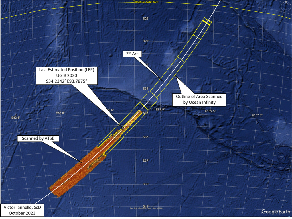
An additional 120,000 square kilometers of seabed was scanned by Ocean Infinity (OI) using a fleet of autonomous underwater vehicles (AUVs). OI extended the length and width of the ATSB’s search so that a full 110 km width was scanned along the 7th arc north to a latitude 31.5 S. The search area was then narrowed to a width of 84 km and extended north along the 7th arc to a latitude of 24.8 S.
Despite this unprecedented large search in the area deemed most likely to find the debris field, the search was unsuccessful. So why wasn’t MH370’s debris field identified? There are only three realistic possibilities:
- The aircraft was manually piloted after fuel exhaustion and glided beyond the area that was previous searched. Although the final BFO values suggest an increasingly high rate of descent that would certainly have resulted in an impact within kilometers of the 7th arc if there had been no further pilot inputs, there is a possibility that the pilot arrested the steep descent and transitioned into a long, efficient glide.
- The point of impact (POI) occurred along the 7th arc further south than 39.4 S or further north than 24.8 S. For instance, although the statistical match to the satellite and drift model data is not as strong, Ed Anderson has discovered an acoustical event along the 7th arc at 8.4 S that he believes is related to MH370. Meanwhile, Paul Smithson believes an impact further south than 39.4 S is within the uncertainty limits of the fuel consumption and drift models, and should not be excluded.
- The debris field lies on the seabed within the area already searched, but was not identified due to challenging terrain, low quality data, or equipment issues.
Here we address the third possibility. In particular, we again consider whether the debris field might be located in the high probability search area previously identified, which is in proximity of the last estimated position (LEP) calculated in the UGIB 2020 study. We further consider whether parts of MH370 were detected but were never fully investigated because they were not part of a larger debris field.
In the figure below, the two inner yellow lines show the approximate limits of the area searched by the vessel GO Phoenix (under contract with the ATSB), and the outer lines show the limits of the Ocean Infinity search area. Also shown in the figure are olive-green areas which represent areas that were not scanned by GO Phoenix’s towfish due to steep terrain. The outlines of these and other areas of missing or low-quality data were made available by Geoscience Australia.
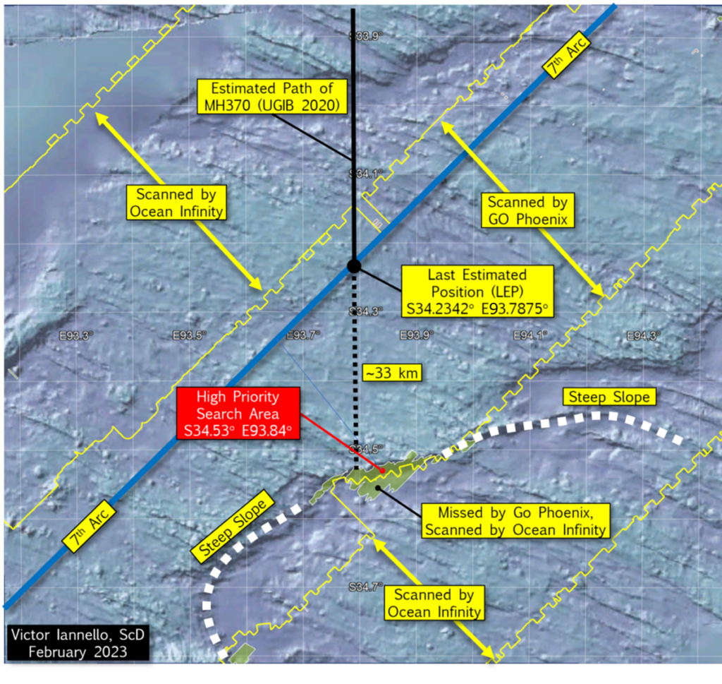
There is a steep slope to the south of the LEP, and the portion of the steep slope that was not scanned by the GO Phoenix towfish is about 60.3 km2. Of this, about half was later scanned by Ocean Infinity AUVs, leaving about 30.5 km2 of seabed surrounding S34.53° E93.84° that was never scanned. We designated this area as a “High Priority Search Area”, and it may be here that the debris field lies.
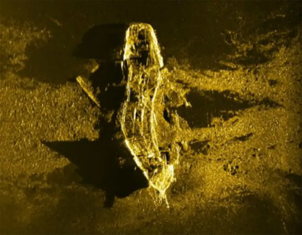
The subsea search for aircraft wreckage that many deem most similar to the search for MH370 was the search for Air France 447 (AF447), which was an Airbus A330 that crashed off the coast of Brazil in June 2009 in around 3000 m (9,800 ft) of water. Floating remnants of the aircraft were found within 2 days of the crash, but the subsea search was not successful in locating the debris field until April 2011, about 2 years after the crash. The sonar image from the debris field, which measured around 200 m x 600 m, is shown below.
AF447 is believed to have impacted the ocean surface without breaking up in flight and with a nose-up attitude. As such, the debris field that AF447 generated may be significantly different from the debris field created by the impact of MH370, as the final two BFO values suggest a high downward acceleration of 0.7g, and descent rates greater than 15,000 fpm. Without pilot intervention, MH370 possibly entered the water at a descent angle greater than 45 deg and at an airspeed approaching or exceeding Mach 1.
The debris from MH370 may more closely resemble the debris from SilkAir 185 rather than the debris from AF447. SilkAir 185 was a Boeing 737 that crashed into the Musi River near Palembang, Sumatra, Indonesia in December 1997. The aircraft experienced a rapid, nearly vertical dive that the US NTSB attributed to control inputs from the captain. During the high speed descent, parts of the control surfaces, including a large portion of the tail section, separated from the fuselage due to the high aerodynamic forces from the high speeds. The airspeed of the fuselage before impact is believed to have exceeded Mach 1.
SilkAir 185’s debris was found in two areas: the main debris field of around 60 m x 80 m at the bottom of the Musi River, which was only 8 m (26 ft) deep; and other larger debris, mainly flight control parts that separated before impact, that were widely scattered on land no closer than 700 m (2,300 ft) from the main debris field. According to the accident report, due to the high energy of the impact, the parts recovered from the river were “highly fragmented and mangled on impact” which made identification difficult.
If MH370 experienced the rapid descent suggested by the final BFO values, then it is probable that the fuselage broke apart before impact, and also probable that many large parts would be found outside of the main debris field. The flaperon recovered on Reunion Island is a good example of a flight control part that may have separated before impact. We would also expect the main debris field to be smaller in extent than for AF447, and within that debris field, the debris to be smaller and more difficult to identify. For instance, for the case of SilkAir 185, the landing gear was identified only by its subcomponents (struts, landing gear door actuators, wheels, brakes, tire pieces, etc.). This counters conventional wisdom that says that aircraft engines and landing gear should be among the easiest parts to identify by sonar on the seafloor, as it was the case for AF447.
The subsea search for MH370 was focused on finding the main debris field at the expense of identifying other parts that may have separated. For the search phase conducted by GO Phoenix, reports were written for a total of 45 “contacts” (observable features in images) that merited a further review. All the contact reports are compiled here. Of these 45 contacts, 24 contacts were within 100 km of the LEP, 10 contacts were within 50 km of the LEP, and 4 contacts were less than 25 km from the LEP. The locations of the contacts are shown in the figure below.
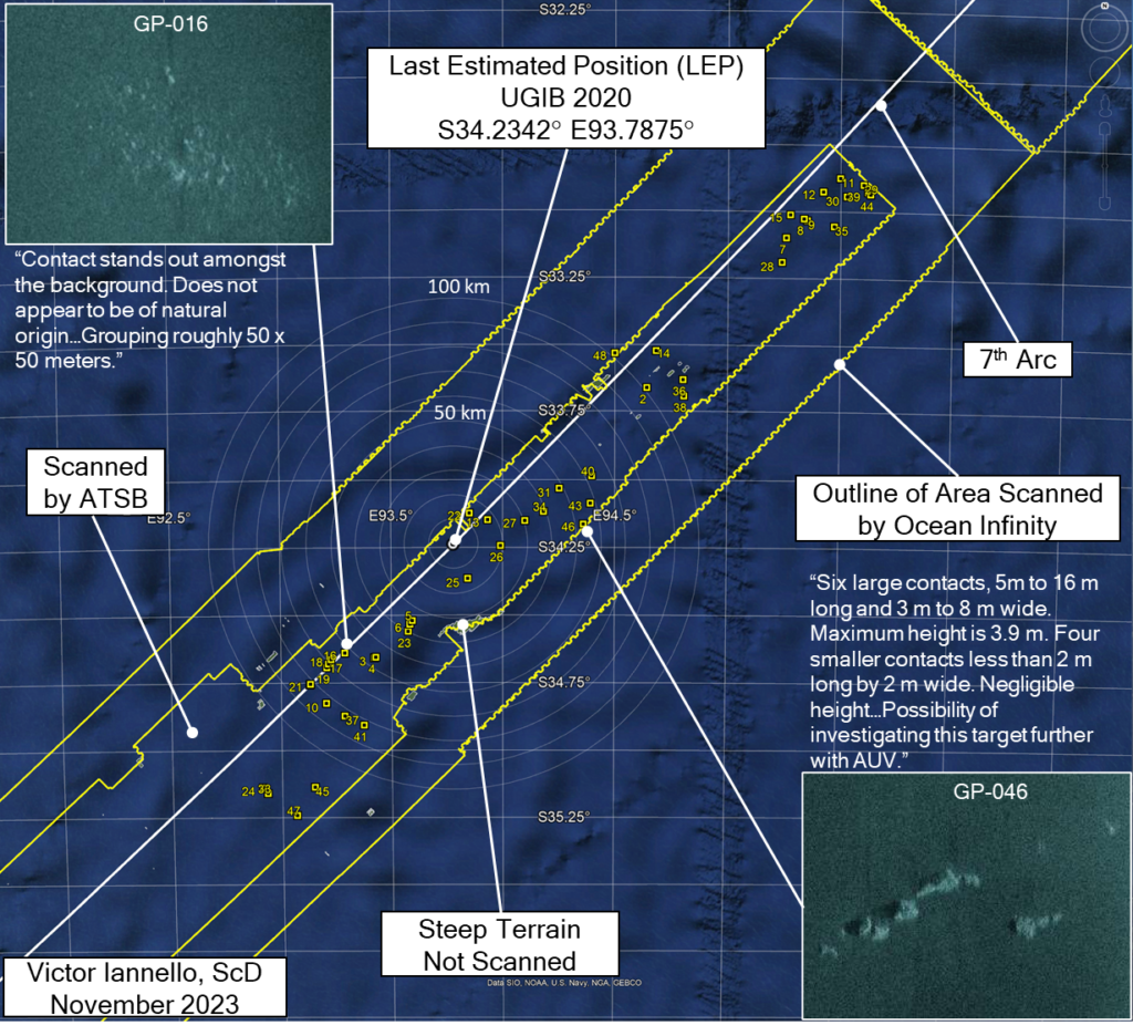
Of the 45 contacts, 11 (GP-002, 016, 018, 019, 021, 025, 026, 028, 030, 031, 047) were described in the reports with phrases like possibly “man-made”, “not geological”, or “not of natural origin”, and one (GP-046) was considered for further investigation with an AUV, which seems to have never been done. Of course, many of the man-made objects on the seafloor could be marine debris from sea vessels unrelated to MH370.
Andy Sherrill is an experienced ocean engineer who has conducted deep water search and salvage operations for a number of missions. He was a key member of the team that reviewed the sonar data for the subsea searches for MH370 that were conducted by the ATSB and Ocean Infinity. Andy was also part of team that identified the debris field for AF447 off the coast of Brazil as well as part of the team that found Argentina’s ARA San Juan submarine. Andy graciously offered these comments as to why many of the MH370 promising contacts were never investigated further:
“Typically, if there were small isolated objects that appeared to be man-made and marked as a target, but nothing else was of interest within several kilometers then we did not investigate further.
We certainly took into account if the debris field did not look like AF447 or any others, however there still needed to be enough debris to be at least a fair amount of the aircraft to warrant further investigation.
Sure a small part of the plane could have drifted and sunk, but we were looking for the main field. A decision was made to focus on finding the main field of debris, not just one small piece – and likely all of those “potentially man made” contacts are from passing vessels given there was no associated debris within several kms.
Having said that, there is always a chance it [a tagged contact] could be from MH370, but based on our assessment the time it took to investigate each of these small contacts was not worth taking vs searching new areas.”
Discussion
As the final BFO values, the lack of IFE log-on, and the end-of-flight simulations all suggest a high speed impact close to the 7th arc, a high priority should be to completely scan the areas closest to the 7th arc. MH370’s debris field may be smaller in area, consist of smaller parts, and be much more difficult to identify than searchers were anticipating. It’s also possible that the debris field is located in an area that was not fully searched due to challenging terrain, low quality data, or equipment issues, such as the steep slope identified above as the high priority search area due south of the LEP. As such, the investigation of many of the contacts previously identified becomes more important, as one or more of these contacts could be parts of MH370 that separated before impact. It’s also possible that one or more contacts are part of a less conspicuous debris field.
We again acknowledge that with pilot inputs, it is possible that MH370 glided after fuel exhaustion beyond the areas that were previously scanned. Therefore, searching wider along the 7th arc should also be part of the search plan if pursuing areas close to the 7th arc is unsuccessful in locating any of MH370’s wreckage.
Update on Nov 3, 2023
Andy Sherrill offered these additional comments:
“We did get rerun over GP16, and collected some higher frequency AUV SSS on that one. Looks highly likely to be geologic in my opinion.
We did not reacquire any more data over GP46, however that one looks very similar to GP16 and I would still classify it as highly likely to be geologic.”