Sonar image of the debris field of the ARA San Juan (Armada Argentina).
About one year after its disappearance, one of Ocean Infinity’s (OI’s) autonomous underwater vehicles (AUVs) has detected the remains of the missing Argentine submarine, the ARA San Juan. From Ocean Infinity’s website:
Ocean Infinity, the seabed exploration company, confirms that it has found ARA San Juan, the Argentine Navy submarine which was lost on 15 November 2017.
In the early hours of 17 November, after two months of seabed search, Ocean Infinity located what has now been confirmed as the wreckage of the ARA San Juan. The submarine was found in a ravine in 920m of water, approximately 600 km east of Comodoro Rivadavia in the Atlantic Ocean.
Oliver Plunkett, Ocean Infinity’s CEO, said:
“Our thoughts are with the many families affected by this terrible tragedy. We sincerely hope that locating the resting place of the ARA San Juan will be of some comfort to them at what must be a profoundly difficult time. Furthermore, we hope our work will lead to their questions being answered and lessons learned which help to prevent anything similar from happening again.
We have received a huge amount of help from many parties who we would like to thank. We are particularly grateful to the Argentinian Navy whose constant support and encouragement was invaluable. In addition, the United Kingdom’s Royal Navy, via the UK Ambassador in Buenos Aires, made a very significant contribution. Numerous others, including the US Navy’s Supervisor of Salvage and Diving, have supported us with expert opinion and analysis. Finally, I would like to extend a special thank you to the whole Ocean Infinity team, especially those offshore as well as our project leaders Andy Sherrell and Nick Lambert, who have all worked tirelessly for this result.”
Ocean Infinity used five Autonomous Underwater Vehicles (AUVs) to carry out the search, which was conducted by a team of approximately 60 crew members on board Seabed Constructor. In addition, three officers of the Argentine Navy and four family members of the crew of the ARA San Juan joined Seabed Constructor to observe the search operation.
Ocean Infinity had committed to conduct the search operation for up to sixty days, and to take on the economic risk of the search, only receiving payment if the submarine was found.
Position Estimates from Acoustic Measurements
The debris field is centered at (-45.9499,-59.7730). Meanwhile, after analyzing the hydro-acoustic data from CTBTO sensors that was collected on Nov 15, 2017, the hot-spot was estimated to be centered at (-46.12,-59.69). That’s a distance of only 20 km, which is an impressive demonstration of the capabilities of the hydro-acoustic analysis.
There was a test explosion on Dec 1, 2017, that was used to calibrate and verify the position estimation model. The position error of the test explosion was 37 km. Therefore, the position error for the debris field was well within what was expected based on the test explosion.
An interesting description of the CTBTO’s hydro-acoustic analysis is presented here.
Implications for the Search of MH370
Unfortunately, the acoustics generated by the impact of MH370 on the ocean surface would not propagate along the “deep sound channel” (DSC) the way an underwater acoustic event does, so the impact likely was not detected by CTBTO sensors.
The San Juan’s debris field was detected earlier this month only after an AUV mission was conducted in a deep trench that was previously scanned from a higher altitude in September. The ability to skim about 100 meters above the challenging surface contour allowed the side scan sonar sensors in the AUV to collect data at the proper altitude to achieve the required image resolution. Because of its limited ability to glide above steep slopes, this resolution would have been very difficult to achieve using a “towfish”, which is a cable-towed underwater vehicle that is similarly equipped with side scan sonar sensors, but is much more limited in maneuverability than an AUV.
The initial seabed search for MH370 was conducted by the vessels Fugro Discovery, Fugro Equator, and GO Phoenix, each using a towfish. These vessels scanned about 120,000 square kilometers of seabed using this technology. Based on the failure of OI to detect the San Juan’s debris field until an AUV mission was conducted in a trench, we have to at least consider the possibility that that the debris field for MH370 was passed over in the initial search but was not detected due to challenging terrain.
In the coming weeks, we’ll learn more about what worked and didn’t work in the search for the San Juan. That knowledge should be applied to MH370 to determine if we can confidently eliminate all of the seabed that has been previously searched.
Update on November 18, 2018
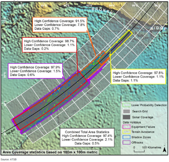
The ATSB did provide statistics for estimating the confidence of detecting MH370 in the 120,000 square kilometers that were initially scanned primarily by towfish. Those statistics are presented in the figure below. About 97.4% of the total area had a detection confidence of 95%, based on the ability to detect a debris field with dimensions of 100 meters by 100 meters. About 2.1% of the area had a detection confidence of 70%, mostly due to difficult terrain, environmental conditions, or degraded data. About 0.5% of the area had no data. The aggregate probability to detect MH370 in the 120,000 square kilometers is therefore about 94%. Although this is high, it is not 100%.
Don Thompson and Mike Exner provided helpful comments for this article.
Area coverage statistics for the ATSB seabed search (ATSB).
Lion Air flight JT610, with 181 passengers and 8 crew, was climbing out of Jakarta on a flight to Pangkal Pinang (Indonesia) when control was lost at around 5,000 ft. Soon after, the Boeing 737-MAX 8 aircraft crashed into the Java Sea northeast of Jakarta. Although we don’t know the cause of the crash, there were some anomalies noted on the previous flight related to sensor disagreements for speed and altitude which required maintenance. Some suspect that these previous issues might have been related to the crash. Luckily, the flight data recorder (FDR), commonly known as a “black box”, was recovered, and the approximate location is known for the cockpit voice recorder (CVR), the other “black box”, so there is a good probability that the cause of the crash can be determined.
Investigators are now claiming they have recovered 69 hours of data from the FDR, which would be sufficient to analyze JT610 as well as the preceding flight which had the anomalous behavior.
The last ADS-B data that we have from Flightradar24 has the aircraft at an altitude of 425 ft, a groundspeed of about 360 knots, and a descent rate of 30,976 fpm. That translates to an approximate true airspeed of 472 knots and a descent angle of about 40 deg. That suggests the aircraft impacted the sea with very high energy. Similarly, the final BFO values for MH370 suggest a downward acceleration of about 0.7g over 8 seconds, reaching a descent rate of about 15,000 fpm. Unless a pilot was at the controls and skillfully recovered from this descent, MH370 also impacted the sea with high energy. Therefore, the debris produced from the JT610 crash gives us some indication of the types of debris probably produced from the crash of MH370.
Indonesia’s National Search and Rescue Agency (BASARNAS) is in charge of the rescue and recovery operation for JT610, which is in water about 100 feet deep, with efforts reportedly hampered by strong underwater currents and limited visibility. Already one volunteer diver has lost his life while recovering body parts.
The video at the top shows floating debris for JT610. If the objects shown are truly representative of the main field of floating debris, it is evidence that a high speed impact produces only small floating parts spread over a fairly limited area. Now admittedly, a B777 is considerably larger than a B737, and the floating debris field should be easier to find. However, the surface search for MH370 in the Southern Indian Ocean (SIO) from the air began weeks after the disappearance, and the dispersive effects of waves and currents in the SIO are strong. The combination of a dispersed field and small parts might explain the failure for the air search to detect floating objects along the 7th arc. The small size of the floating parts might also explain why satellite images along the 7th arc have not spotted aircraft debris.
Despite the likelihood of small floating debris, the underwater searchers for MH370 expect to find a fairly substantial debris field (bigger than 100 m) and substantial, distinguishable objects such as the landing gear and engines, consistent with the debris field of Air France 447. This is also consistent with the parts of JT610 that have already been found on the seabed. For instance, the picture below shows an engine and part of the landing gear of JT610.
To locate parts on the seabed, BASARNAS is using a combination of technologies, such as multi-beam echo sounders (MBES), side-scan sonar (SSS), magnetometers, and remotely-operated vehicles (ROV). The SSS technology has been the workhorse for the subsea search of MH370, used in both the towed vehicles and the underwater drones.
The video below shows divers helping to retrieve debris from the seabed.
The debris recovered from the crash of JT610 helps explain why no MH370 floating debris was spotted by air and by satellite along the 7th arc, and why we remain hopeful that it will be detected on the seabed with sonar sensors once the correct search area is selected.
Update on November 13, 2018
Here’s a Wall Street Journal story that discusses the stall-protection system that likely led to the crash of JT610.
Boeing Withheld Information on 737 Model, According to Safety Experts and Others
Data related to a new flight-control feature suspected of playing a role in crash in Indonesia
By Andy Pasztor and Andrew Tangel Nov. 12, 2018 11:16 p.m. ET
Boeing Co. withheld information about potential hazards associated with a new flight-control feature suspected of playing a role in last month’s fatal Lion Air jet crash, according to safety experts involved in the investigation, as well as midlevel FAA officials and airline pilots.
The automated stall-prevention system on Boeing 737 MAX 8 and MAX 9 models—intended to help cockpit crews avoid mistakenly raising a plane’s nose dangerously high—under unusual conditions can push it down unexpectedly and so strongly that flight crews can’t pull it back up. Such a scenario, Boeing told airlines in a world-wide safety bulletin roughly a week after the accident, can result in a steep dive or crash—even if pilots are manually flying the jetliner and don’t expect flight-control computers to kick in.
That warning came as a surprise to many pilots who fly the latest models for U.S carriers. Safety experts involved in and tracking the investigation said that at U.S. carriers, neither airline managers nor pilots had been told such a system had been added to the latest 737 variant—and therefore aviators typically weren’t prepared to cope with the possible risks.
“It’s pretty asinine for them to put a system on an airplane and not tell the pilots who are operating the airplane, especially when it deals with flight controls,” said Capt. Mike Michaelis, chairman of the safety committee for the Allied Pilots Association, which represents about 15,000 American Airlines pilots. “Why weren’t they trained on it?”
One Federal Aviation Administration manager familiar with the details said the new flight-control systems weren’t highlighted in any training materials or during lengthy discussions between carriers and regulators about phasing in the latest 737 derivatives.
Boeing declined to immediately answer specific questions Monday. “We are taking every measure to fully understand all aspects of this incident, working closely with the investigating team and all regulatory authorities involved,” the company said in a statement. “We are confident in the safety of the 737 MAX.”
On Monday, an FAA statement reiterated that the agency had mandated flight manual changes to emphasize proper pilot responses to the new flight-control systems. “The FAA will take further action if findings from the accident investigation warrant,” the statement noted, but declined to comment further.
Boeing marketed the MAX 8 partly by telling customers it wouldn’t need pilots to undergo additional simulator training beyond that already required for older versions, according to industry and government officials. One high-ranking Boeing official said the company had decided against disclosing more details to cockpit crews due to concerns about inundating average pilots with too much information—and significantly more technical data—than they needed or could digest.
Minutes after takeoff from Jakarta in good weather, Lion Air Flight 610 experienced problems with airspeed indicators and a related system that feeds data to computers about the angle of the nose. The crash killed all 189 people on board.
Investigators haven’t described the precise sequence of events that caused the twin-engine jet to plummet into the Java Sea at a steep angle and high speed. But Indonesian authorities already have called for stepped-up pilot training and suggested they are delving into design issues. In the U.S. at least, substantial training changes will have to wait until new flight simulators are delivered to carriers.
The focus of the probe is shifting away from its early emphasis on individual system malfunctions and suspected pilot mistakes, according to people tracking developments.
Instead, these people said, U.S. and Indonesian crash investigators increasingly are delving into the way the MAX 8’s automated flight-control systems interact with each other, and how rigorously the FAA and Boeing analyzed potential hazards in the event some of them malfunction and feed incorrect or unreliable data to the plane’s computers. Swiftly turning off the automated feature is the solution in such cases.
Earlier 737 versions have different stall-protection systems, that don’t automatically drive down the nose even when other functions of the plane’s autopilot are turned off.
Yet operation of those older systems was highlighted in training over the years, and pilots had to memorize steps to counteract potentially dangerous unintended consequences. MAX 8 training materials don’t include a requirement to memorize the steps to turn off the stall-protection system.
Stepped-up scrutiny of the latest 737 MAX features applies to more than 200 of the models that have been delivered to customers around the world, including Southwest Airlines , American Airlines and United Airlines. Boeing’s 737 factory near Seattle currently churns out 52 planes a month.
“We’re pissed that Boeing didn’t tell the companies and the pilots didn’t get notice obviously, as well,” said Capt. Jon Weaks, president of Southwest Airlines Co.’s pilot union. “But what we need now is…to make sure there is nothing else Boeing has not told the companies or the pilots.”
Like Mr. Weaks, some FAA managers and industry officials aren’t satisfied with what they contend is Boeing’s belated candor.
Boeing is working on a software fix, according to industry and government officials, that would likely mitigate risks. On Saturday, the company went further than before in spelling out dangers pilots can face if they misinterpret or respond too slowly to counter automated commands.
In a message sent to all 737 operators, and reviewed by The Wall Street Journal, the Chicago plane maker explained in painstaking detail the engineering principles and operational parameters behind the latest automation.
That message was more detailed than the bulletin Boeing voluntarily issued earlier, alerting pilots about the potential hazard—and touching off debate over the stall-prevention system’s design. Within hours, the FAA followed up with its emergency directive mandating changes in flight manuals.
Such interim efforts “are very appropriate in the near term to increase pilot awareness,” said John Cox, a former 737 pilot and ex-crash investigator for North America’s largest pilots union who now consults on safety for carriers and business aviation.
Boeing’s latest communications with airlines prompted American’s union to alert its members. “This is the first description you, as 737 pilots, have seen,” the union pointedly told pilots in a memo, referring to the 737 MAX stall-prevention system. Noting the system wasn’t mentioned in American Airlines’ or Boeing manuals, the union memo added: “It will be soon.”
The ultimate way to counteract dangerous automated nose-down commands is basically the same for old and new systems, though checklists and procedures for the 737 MAX 8 entail more steps and take more time. Investigators and safety experts are convinced that as the emergency worsened, the Lion Air crew had barely seconds in which they could have diagnosed the problem and taken action to save the aircraft.
Shortly before the plane crashed, according to local Indonesian media reports, one of the pilots told air-traffic controllers about difficulties controlling the plane.
Ghyslain Wattrelos, who lost family members traveling on MH370
The article that follows, translated from French, appeared on the website 20 Minutes with AFP:
While all other countries have stopped investigating, France is not giving up. The investigators in charge of the case of the disappearance of flight MH370 of Malaysia Airlines hope to soon go to the United States where crucial investigations must move forward, Ghyslain Wattrelos, who lost four family members in the disaster, announced Thursday.
On March 8, 2014, 239 people disappeared after taking off from Kuala Lumpur aboard a Boeing bound for Beijing. Other than some debris that seem to belong to it were recovered in the Indian Ocean, no trace of the 239 passengers has ever been found. Ghyslain Wattrelos has notably lost his wife and two of his children in the plane’s disappearance.
On Thursday, he was received with his lawyer Marie Dosé by the judge of instruction in charge of the judicial inquiry opened in France, to take stock of the investigations and the avenues to explore by the investigators.
Questions for the FBI and Boeing
Among the priorities that mobilize the investigators, a trip to the United States is “back on the agenda”. A previous trip was cancelled in September, even though it was part of an international rogatory commission launched in October 2017, they announced at a press conference Thursday. According to Dosé, this trip had to be canceled, as the US authorities opposed “confidentiality clauses” and then the “industrial secret” of the manufacturer Boeing.
“We are a little angry and now we want to say stop, it is time that the United States really cooperate on this issue,” responded Ghyslain Wattrelos. “It is necessary to go there because there are three entities that hold important information for understanding what happened on this flight,” he continued. Starting with Boeing and the FBI, even if the investigators seem to have obtained assurances from the intelligence agency that they could be received, he said.
A hacking of Satcom?
But attention is now also focused on a third entity, a company uncovered by investigators. The challenge, according to Ghyslain Wattrelos, is whether it sells software capable of reprogramming or even hacking the Satcom, the antenna that communicates to the Inmarsat satellite signal from the aircraft. “The essential trail is the Inmarsat data. Either they are wrong or they have been hacked,” he says. However, these satellite data are essential to better understand the trajectory of the aircraft.”
The release of the Malaysian investigation report in July had dampened Ghyslain Wattrelos’ hopes, but since then French investigators have suggested new theories to explore. In particular, the investigators found “inconsistencies” in the Malaysian investigation’s official report, and the presence of “curious” passengers, whom “we should continue to investigate”. Among them is a Malaysian traveler with a troubling profile: he was seated under the Satcom module, and proved to be an expert in aeronautics, according to Ghyslain Wattrelos and his lawyer.
[End of story]
It’s not clear what additional information the French investigators expect to obtain while in the US. Boeing has cooperated with the Annex 13 investigation team, and is unlikely to provide private French investigators with data that has not already been made public. Meanwhile, the FBI is unlikely to release information on matters related to ongoing or past investigations.
The mysterious “third entity” referred to by Mr Wattrelos that might be selling software capable of maliciously altering SATCOM data is also unknown, although there are a handful of companies in the US and Canada that supply hardware and software for designing, building, and testing parts of the Inmarsat network.
Independent investigators that are studying this mystery are at an impasse. Although the overwhelming consensus is that MH370 did indeed crash in the Southern Indian Ocean, the considerable efforts of official and private investigators have not succeeded in locating the debris field on the seabed. The data we have, notably the satellite data, is imprecise, so additional data is needed to reconstruct the trajectory of the plane.
There is always the chance that during Mr Wattrelos’ visit to the US, some new evidence or insights will be uncovered that help us to better understand the disappearance and to find the plane.
More likely, the existence of helpful new information will be found in Malaysia.
Update on October 23, 2018
The following article, translated from French, was published in the L’Essor, which is the [unofficial, self-described] French journal for the military police.
MH370: Gendarmes waiting for a green light for a trip to the United States
The investigators of the research section (SR) of the Gendarmerie Air Transport (GTA) are waiting for the green light from US authorities to travel to the United States related to the case of the disappearance of the flight MH370 Malaysia airlines, more than four years ago.
The SR of the GTA is responsible for the judicial inquiry, opened in France, on the death of 239 people, including four French, aboard the Boeing who disappeared on March 8, 2014 after taking off from Kuala Lumpur for Beijing. Debris likely to belong to the aircraft have been discovered in the Indian Ocean but no trace of the 239 passengers has ever been found.
The gendarmes work within the framework of an international rogatory commission launched in October 2017 by the French justice. A trip to the United States, scheduled for September, had to be canceled and French investigators are waiting for the green light from the US authorities.
The investigators want to check overseas if a US company sells software capable of reprogramming or even hacking the Satcom. This system is used by airlines to transmit messages about the state of the aircraft in flight and its communications.
[End of story]
This story, if true, suggests that the French judiciary system, and in turn the military police that are assigned to the case, are seriously considering whether the Inmarsat data was corrupted by a malicious intrusion into the SATCOM onboard MH370. Considering that the Inmarsat data is consistent with the aircraft crashing in the SIO near the 7th arc, and that the timing and location of the recovered parts from the aircraft also suggest that the aircraft crashed in the SIO, to doubt the Inmarsat data implies doubting the veracity of the recovered parts. This is the first time a government investigative body is known to be seriously considering a hack of the SATCOM combined with planting of debris.
To say the least, most private investigators believe there are more productive avenues to pursue. However, an honest, competent investigation of any type is to be welcomed, and there is always the chance some new evidence or insights will be uncovered that help us to better understand the disappearance and to find the plane.
Today, Malaysia’s Ministry of Transport quietly released the full ACARS message log for MH370. The new log confirms that the traffic logs presented in previous reports were incomplete and edited, as asserted in a previous blog article. This release comes on the heels of a strong denial from Malaysia Airlines stating that it has “provided full cooperation and assistance to all respective authorities”.
Notably, the new log contains an additional ACARS message that was sent from MAS Operations Dispatch Center (ODC) and destined for MH370 over the VHF link. The message was sent at 18:38:51 and was intended to be displayed in the cockpit on a Control Display Unit (CDU), which a pilot uses to perform tasks such as programming the flight computers. The message was not received by MH370, and was re-sent by MAS ODC at 18:39:52, 18:40:42, and 18:41:52, failing each time. The text of the message was:
DEAR MH370. PLS ACK TEST MSG. RGDS/OC.
The new log confirms that there was a renewed attempt to initiate communications with MH370 using ACARS over the VHF link at 18:38:51. The error messages that were generated confirm that the VHF link was not available at that time, likely because MH370 was not logged into ARINC’s server. ARINC was MAS’ service provider for ACARS over VHF.
Also of note is the new ACARS message was sent about a minute before an attempted telephone call over the satellite link at 18:39:56, suggesting an increase in activity at MAS ODC at this time.
The new log contains other traffic between MAS ODC and other ground computers. This data is under examination for additional clues. The new log also confirms that the name of the MAS ODC employee that sent the ACARS messages was redacted from the message logs in previous reports.
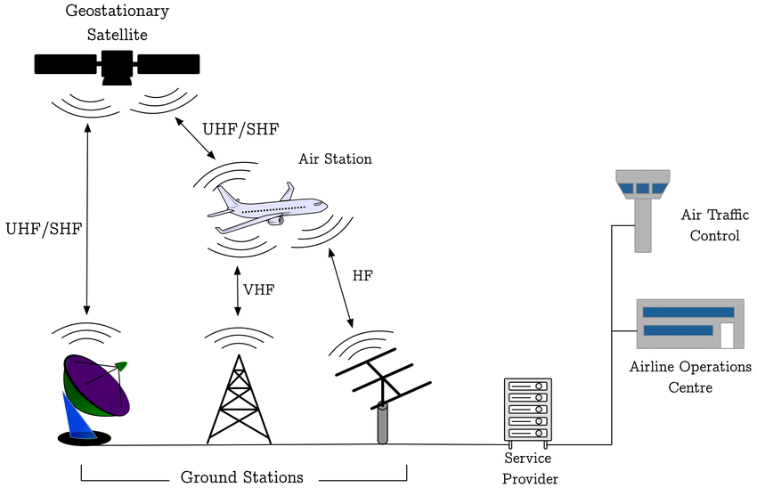
ACARS Message Paths ( From “Analyzing Security Breaches in ACARS”, Smith et al., 2017)
Fellow MH370 Independent Group members Don Thompson and Richard Godfrey have found some anomalies in the message logs that were included in Factual Information (FI) released by Malaysia on March 8, 2015, and the Safety Investigation Report (SIR) released by Malaysia on July 30, 2018. The logs from these two reports document the communication between MAS Operations Dispatch Center (ODC) and service providers that route messages over SATCOM and VHF paths, as part of the Aircraft Communications Addressing and Reporting System (ACARS). The anomalies suggest the traffic logs appearing in the reports are not complete, and what appears in the reports has been modified.
A simplified schematic of the ACARS is shown in the figure. For MAS, the service provider for satellite communications is SITA using the Inmarsat network and the service provider for VHF communications is ARINC using a network of ground stations.
Missing Messages Between 18:15:23 and 18:43:33
According to text in both the FI and the SIR, an urgent message from MAS ODC was submitted at 18:03 and then re-transmitted multiple times:
The first message sent to the aircraft cockpit printer from the MASODC was at 1803:23 UTC. The ACARS message requested thecrew to contact the HCM ACC immediately. The incoming downlinkmessage at 1803:24 UTC showed the message failed to reach theaircraft. Messages are auto transmitted every 2 minutes and themessage was retransmitted until 1843:33 UTC but all messagesfailed to get a response. Automated downlink message by ACARSshowed ‘failed’.
However, the last message from MAS ODC that was shown in both the FI and SIR traffic logs occurred at 18:15:23, and not the 18:43:33 stated in the text. This means that either the explanatory text is wrong, or the traffic logs do not contain all the message traffic.
VHF Messages Not Included
The missing messages could be explained if they were routed via the VHF link. For the ACARS traffic log in the FI, the filter parameters used to extract the message records included only SATCOM traffic for the time period 12:48:00 to 20:00:00, so that if any VHF messages were exchanged, those messages would not be included in the traffic log. (The filter parameters appear at the top of each page of the traffic log in Appendix 1.9A.)
The facts surrounding the ACARS traffic log in the SIR (also Appendix 1.9A) are more suspicious. For Page 1 of the log, the filter parameters did not limit the messages to only SATCOM messages. In fact, at 15:54:31, there is a message submitted by MAS ODC over the VHF link that requests personnel on the aircraft to re-configure the center VHF radio so that future messages would be exchanged via SATCOM. However, starting with Page 2 of the report, the filter parameters used to generate the remaining pages of the report were changed so that VHF messages, if any occurred, were excluded.
The change in filter parameters after Page 1 is unexplained. Two messages received by MAS ODC at 15:54:41 and 15:54:53 appearing at the bottom of Page 1 are repeated at the top of Page 2. The change in filter parameters and the repeated messages are clear evidence that the traffic log in the SIR is actually two reports that were pieced together and presented as a single report.
Edited Text
As it appears in the ACARS traffic log in the SIR, the text message that was sent by MAS ODC at 18:03:23 is:
URGET [sic] REQUEST
PLS CONTACT HO CHI MING [sic] ATC ASAP
THEY COMPLAIN CANNOT TRACK YOU ON THEIR RADAR
I RECEIVED CALL FROM SUBANG CENTRE
PLS ACK THESE MSG
REGARDS
However, the last line of the message appears to have been edited. By examining the ASCII characters embedded in the PDF version of Appendix 1.9A, the following text can be extracted:
REGARDS
MXXXXX
where MXXXXX is an actual name with six letters beginning with M.
It is disappointing that more than four years after MH370’s disappearance, we are still asking Malaysia to release withheld data. The military radar data is another example of a data set that has never been released in full despite its significance in providing information about how the aircraft was flown after the diversion from the flight plan.
It is important that Malaysia provide a complete, unmodified log of all ACARS communications on SATCOM, VHF, and HF paths for the period between 12:48 and 20:00 on March 7, 2014. This is particularly significant in light of questions surrounding the delayed response of Malaysian authorities after MH370 went missing.
Update on Sept 4, 2018
The Daily Star reports that it has received a statement from Malaysia Airlines about the anomalies in the traffic data logs that were reported in the article above:
A spokesman told Daily Star Online: “Malaysian Airline System Berhad (Administrator Appointed) (“MAS) is aware of the recent media reports alleging anomalies to the traffic data logs in the Safety Investigation Report published by the Malaysian ICAO Annex 13 Safety Investigation Team for MH370.
“MAS wishes to state that MAS has provided full cooperation and assistance to all respective authorities on the investigation for MH370, including the submission of relevant documents necessary for the investigation.
MAS will continue to cooperate with the Authorities and if necessary, provide any information to them in line with international requirements and applicable laws.”
Conspicuously absent is an explanation for the missing messages and the edited logs.
Boeing simulations of MH370 at end-of-flight. (Click on image to enlarge.)
Introduction
With the failure of the recent search by Ocean Infinity to locate the debris field along the 7th arc at latitudes as far north as 25S and at widths equal to or exceeding +/- 22 NM, we consider whether it is possible that with the assumption of uncontrolled flight, the plane could have impacted the ocean farther than 22 NM from the 7th arc, and was missed because the search along the arc was too narrow.
At each phase in the subsea search for MH370, the search area was defined by following parameters:
A range of latitudes along the 7th arc
A width inwards and outwards from the 7th arc
The range of latitudes for the search was determined by analysis of the satellite data, aircraft performance, and drift models. Collectively, these data sets constrain the position that MH370 crossed the 7th arc. Unfortunately, due to the imprecise nature of these data sets, official and independent investigators have proposed a fairly large range of latitudes, and this continues to be the subject of debate.
In a parallel effort by the ATSB, the width inwards and outwards from the arc was estimated by the distance the aircraft could have glided after fuel exhaustion. With the assumption that there were no pilot inputs after fuel exhaustion, this distance was determined by end-of-flight simulations conducted by Boeing based on aircraft conditions requested by the ATSB. The simulations were completed in Boeing’s engineering simulator, which offers high fidelity of the aircraft’s performance. Some of the results of these simulations were presented in an ATSB report entitled MH370 Search and Debris Update, released in November 2016.
Simulation Results
Because of the importance of the simulations in establishing the search width, I asked the ATSB for more details about the conditions modeled and the results of the ten simulations. (Because Boeing conducted the simulations based on conditions requested by the ATSB in support of the search, they are an ATSB product.) Although legal restrictions prevent the ATSB from providing specific details about each of the ten simulations (referred to as Cases 1-10), the ATSB did reveal that the initial speeds varied between M0.75 and M0.83, the starting altitudes were either FL350 or FL400, the initial headings were either 178°, 184° or 190°, and turbulence was either light or moderate. Winds at various altitudes were included in the simulations.
In addition to these general descriptions, the ATSB did provide me with numerical results of the ten simulation runs in the form of X, Y, and altitude in one second increments, where X is the E-W position in NM, Y is the N-S position in NM, and the altitude is in feet. (The ATSB deliberately did not include the latitude and longitude values in these files so that there was no association with a particular crossing of the 7th arc.) The ATSB has permitted me to share these results on this blog so that a broader group of investigators can independently analyze the results. To my knowledge, this is the first time these results have been released to the public.
Although not included in the files, derived quantities such as groundspeed, Mach number, track, vertical speed, vertical acceleration, bank angle, and wing loading are all calculable, although some parameters such as Mach number and calibrated airspeed need assumptions about the wind and temperature fields.
A presentation of the detailed technical analyses of all the simulations would be lengthy and not appropriate for a blog post. However, some generalized observations and results are summarized below:
There were two groups of simulations. In the first group (Cases 1,2,5,7,8,9), the autopilot was lost after the flameout of the second (left) engine, which corresponds to a “normal” configuration of the electrical system.
In the second group (Cases 3,4,6,10), the electrical configuration was in an “alternate” configuration in which the left generator and left backup generator were isolated with switches in the overhead panel. In this case, when the right engine is running, power is supplied to the left bus from the right bus through the bus tie breaker. However, after the first (right) engine flames out, both main AC busses and both transfer busses lose power, which causes the flight control mode to transition to “secondary” and the autopilot and autothrottle disengage, even as the left engine continues to provide thrust.
The SATCOM’s log-on request at 00:19 is assumed to occur two minutes after the loss of the autopilot. (The two minute interval assumes the APU would take one minute to start supplying power, and the SDU would subsequently take one minute to power up and request a log-on to the satellite.) The ATSB has adjusted this position in all the simulations so that the two-minute mark occurs at the same X,Y values, and the paths can be compared. The two-minute mark serves as a reference position (labeled with “2 mins” in the figure above).
For all ten simulations, the paths stay within a distance of 32 NM from the reference position. However, since all paths are curved, the farthest impact point from the 7th arc is only about 15 NM, and depends on the track angle between the initial path and the arc tangent.
There were five simulations (Cases 3,4,5,6,10) in which the rate of descent exceeded 15,000 fpm and the downward acceleration exceeded 0.67g, which are the values indicated by the two final values of BFO. This included all four cases with the “alternate” electrical configuration, and one with normal configuration. The maximum downward acceleration for these cases ranged between 0.87g and 1.30g.
For the five simulations (Cases 3,4,5,6,10) with high descent rates, the impact occurs within 14 NM from the reference position, and about the same distance from the 7th arc, depending on the track angle between the initial path and the arc tangent.
For the five simulations (Cases 3,4,5,6,10) with high descent rates, the descent rate of 15,000 fpm and the downward acceleration of 0.67g occur at different times, and are not predicted to occur at the time of the log-on. If the impact distance is measured from the point at which the descent rate first exceeds 15,000 fpm, the distance ranges between 4.7 NM and 7.9 NM.
In none of the simulations did the plane fly straight with level wings after the autopilot was disengaged. Ultimately, the magnitude and direction of the bank that develops is the net effect of a many factors, including thrust asymmetry, TAC, manual rudder input, weight imbalance, aerodynamic asymmetry, and turbulence, with the dihedral effect of the wings and center-of-mass tending to restore the bank to zero.
Simulation of Alternate Electrical Configuration
Case 6: A simulated end-of-flight path for the left generators turned off before fuel exhaustion. (Click on image to enlarge.)
The four simulations (Cases 3,4,6,10) with the alternate electrical configuration are interesting because in all cases, the descent rates and downwards accelerations exceeded the values suggested by the final BFOs, and the high speed descent is achieved within minutes of loss of the autopilot. To further illustrate the sequence of events, we consider Case 6, with initial conditions of a groundspeed of 425 knots at an altitude of 35,000 ft, and shown in the figure above.
When there is no more fuel in the right tank, the right engine coasts down and the left engine speed increases to full thrust. The loss of AC power causes a transition to secondary control mode, and the autopilot and the autothrust are disengaged. As the right engine coasts down, the automatic thrust asymmetry compensation (TAC) will apply left rudder, but the amount of rudder does not change after the flight control mode degrades to secondary.
After the right engine flames out, there is a slight turn to the right, which means the rudder position does not completely balance the yaw from the resulting thrust asymmetry. It is possible that the transition to secondary control mode occurs before the TAC can apply sufficient rudder input to fully compensate for the thrust asymmetry of no right engine thrust and full thrust of the left.
At some point, the remaining fuel in the left tank is exhausted, and the left engine shuts down. With both engines producing no thrust, the left rudder position now causes a steep turn to the left, and the plane descends. At the point it reaches 27,000 ft, the descent rate is 15,000 fpm, and it has achieved a downward acceleration of 0.3g over the preceding eight seconds. The plane levels off at about 19,000 ft, and then begins to again rapidly descend, reaching a descent rate of 15,000 fpm at about 18,000 ft, and impacting the sea about 3.3 NM from this point. The impact distance from the earlier point of reaching a descent rate of 15,000 fpm is about 7.9 NM.
Discussion
[Phrases in italics were added on Aug 21, 2018 for clarity.]
If we consider that the end-of-flight Boeing simulations were representative of the actual conditions of MH370, we have three possibilities:
If the flight was uncontrolled after fuel exhaustion, and if we ignore the final BFO values, the plane impacted no farther than about 15 NM from the 7th arc.
If the flight was uncontrolled after fuel exhaustion, and if the descent rates suggested by the final BFO values are valid, then the aircraft impacted no more than about 8 NM from the 7th arc.
If the flight was controlled after fuel exhaustion, an efficient, stable glide starting at about 40,000 ft could have achieved a distance of 120+ NM from the 7th arc.
Possibilities (1) and (2) suggest the next search should occur along the 7th arc north of 25S latitude at a width of about +/-25 NM. The +/-25 NM is an estimate that includes uncertainty in the simulation models and uncertainty in the final BTO values.
Because possibility (3) requires pilot inputs after fuel exhaustion, if this occurred, we have to assume that pilot inputs also occurred during the powered part of the flight after 19:41. As such, there would be no reason to believe that paths reconstructed with the assumption of automated flight with no pilot inputs are representative of the path actually flown. The large width (+/- 120 NM) and the difficulty in objectively constraining the crossing latitude of the 7th arc would make it difficult to define a manageable search area without additional information.
Until additional information or insights become available, it will be difficult to establish a new search area.
As expected, the Safety Investigation Report on MH370 offered no explanation on the cause of the disappearance. “The answer can only be conclusive if the wreckage is found,” Kok Soo Chon, head of the MH370 safety investigation team, told reporters. However, Malaysian investigators did surmise the plane was intentionally diverted, likely due to unlawful interference by a third party. The Malaysia investigators also believe the disappearance could not have been a deliberate act by the pilots based on their background, training, and mental health.
As all the passengers and crew were cleared, who was this third party that diverted the plane? How can Malaysian investigators ignore that the captain had the best opportunity and capability to divert the plane? How does the compressed timeline of the diversion fit any other possibility if the diversion was intentional? It is understandable that the Safety Report did not apportion blame to the captain. However, it is not understandable that the report deflected blame to an unnamed third party.
The report, including the appendices, is 1,423 pages, and it will take some number of days for independent investigators to thoroughly pore over the entire contents and provide thoughtful comments and analysis. However, based on an initial review, there are some technical questions and inconsistencies that are apparent:
Radar data
The report provides more details about the radar data, but Malaysia fails to provide the raw military data that would allow an independent review. (The civilian radar data was previously made available through an unsanctioned release, and published in a previous blog post.) The military radar includes speed and altitude data, in addition to latitude and longitude at each capture. However, some of the variations in speed and altitude are beyond the capabilities of the plane. For instance, the measured speed and altitude at 18:01:59 UTC are 589 knots and 58,200 ft. One minute later, the speed and altitude are recorded as 492 knots and 4,800 ft. The investigative team was warned that the altitude and speed extracted from the data are subjected to inherent error. The only useful information obtained from the Military radar was the latitude and longitude position of the aircraft as this data is reasonably accurate. How the military radar data can be so far out of calibration is unexplained.
After all this time, we still can’t be sure what radar data is available as MH370 passed over the Malacca Strait. According to the main body of this report, the radar target disappeared at 18:01:59 near Pulau Perak, and re-appeared at 18:15:25 along airway N571 between waypoints VAMPI and MEKAR, disappearing at 18:22:12 about 10 NM past MEKAR. However, in an Appendix 1.6E, Boeing reports that after 18:01:59, there was only one capture at 18:22:12. It appears that the radar data provided to Boeing is consistent with the data provided to the ATSB, but Malaysia claims there were additional captures along airway N571 between 18:15:25 and 18:22:12.
We also can’t be sure when the unidentified radar targets captured over the Malay peninsula were first recognized as MH370. According the Safety Report, On the day of the disappearance of MH370, the Military radar system recognised the ‘blip’ that appeared west after the left turn over IGARI was that of MH370. Even with the loss of SSR data, the Military long range air defence radar with Primary Surveillance Radar (PSR) capabilities affirmed that it was MH370 based on its track behaviour, characteristics and constant/continuous track pattern/trend. Therefore, the Military did not pursue to intercept the aircraft since it was ‘friendly’ and did not pose any threat to national airspace security, integrity and sovereignty. In light of the claim that the military was fully aware of the path of MH370, it is not explained why the initial Search and Rescue operations were coordinated in the South China Sea to the east of Malaysia, and proceeded for some number of days before they were moved west of Malaysia to the Indian Ocean.
Pilot Simulator Data
Citing the Royal Malaysian Police (RMP) report from May 2014, the Safety Report says It was also discovered that there were seven ‘manually programmed’waypoint4 coordinates … that when connectedtogether, will create a flight path from KLIA to an area south of the IndianOcean through the Andaman Sea. These coordinates were stored in theVolume Shadow Information (VSI) file dated 03 February 2014.The function of this file was to save information when a computer is left idle for more than 15 minutes. Hence, the RMP Forensic Report could not determine if the waypoints came from one or more files.
What is not mentioned is that certain values that were common to the data sets indicate that these files were likely from the same simulation. This was first documented in a technical paper I co-authored with Yves Guillaume, and summarized in a previous blog post. Also included in the previous blog post were statements from the ATSB indicating that the chronological order of the data sets matches a flight departing KLIA, flying over the Malacca Strait, continuing past the Andaman Islands, turning to the south, and exhausting fuel in the SIO, in the same order that the progressively depleting fuel levels suggest. The time values also indicate that the flight session lasted for about one hour, suggesting the position of the aircraft in the simulation was manually advanced and the fuel levels manually depleted.
There are other strange facts surrounding the simulator data. For instance, Malaysia does not explain why only fragments of the data files were recovered, as the reconstruction of the entire contents of the data files should have been possible using the data in the Shadow Volume. The missing portions of the data files include important information that would be stored in the flight management computers (FMCs), including flight plans. Also, the time stamp data that was included in the data files that were made available to the ATSB by the Australian Federal Police was not included in the RMP report.
The RMP conclusion that there were no unusual activities other than game-related flight simulations is odd considering the extraordinary coincidence that a simulated flight including a departure from KLIA and ending in fuel exhaustion in the SIO was recovered after the disappearance.
Investigation of the Flaperon
After the flaperon was recovered from Reunion Island, which is sovereign territory of France, French scientists performed tests to determine the flaperon’s provenance, to analyze the attached marine biology, to determine its buoyancy and other hydrodynamic characteristics, and to investigate the damage to determine how the flaperon separated from the aircraft. To the French team, it appeared that the flaperon impacted the water while still attached to the aeroplane and that at the time of the impact it was deflected. The implication is that water forces from an attempted ditching caused the flaperon to separate rather than in-flight during a high speed descent. The French were careful to advise that this is only an hypothesis because of the limited data made available to them by Boeing, and because of the complicated dynamics of the impact mechanics.
Nonetheless, if it can be proven that the aircraft was in a controlled descent at the time it impacted the ocean, the distance from the 7th arc could be greater than 120 NM, as there could have been a long glide after fuel exhaustion. A controlled descent after fuel exhaustion would also leave open the possibility of pilot navigational inputs after 19:41, and possible paths would include crossing the 7th arc over a large range of latitudes. These unknowns would make it very difficult to define a new search area of a manageable size. For this reason, it is critical that mechanism that led to separation of the flaperon be determined with a higher level of certainty.
First Officer’s Cell Phone Connect
The First Officer’s cell phone registered on a cell tower as MH370 passed to the south of Penang Island. Although it would be unlikely that a cell phone connection would persist long enough to complete a call, a cell phone registration of short duration and at cruise altitude is not that uncommon.
Considering the large number of Malaysian passengers and crew that were likely carrying cell phones compatible with the Malaysian cell network, and with some fraction of those phones likely in an operational configuration during the flight, it is odd that other cell phone registrations did not occur. It is unexplained whether or not a systematic review of the cell phone numbers of all passengers and crew was ever performed.
Final Comments
It is unlikely that another search for MH370 will occur unless a case can be made that there is a reasonable probability of success. Unfortunately, the Safety Report raises more questions than it answers, and it will be difficult to use the information in the report to define a search area of a manageable size. The answers to some questions will not be known until the flight data recorder is recovered. However, the answers to other questions are known to Malaysian authorities today. Any remaining chance to find MH370 squarely rests on the willingness of the new Malaysian administration to cooperatively work with official and independent investigators.
Simulated drift of the flaperon after 389 days from 22S latitude (Godfrey).
Introduction
Fellow MH370 Independent Group (IG) member Richard Godfrey has completed a new drift analysis that suggests that MH370 might have crashed further north on the 7th arc than was previously searched. Richard concludes that the recovered aircraft debris from the beaches of East Africa could have originated from potential impact sites as far north as 20.5°S latitude. He is recommending that a new subsea search cover the part of the 7th arc between 25°S and 20°S latitudes based on his new drift analysis. As further justification for a new search to the north, he also cites the reconstructed flight path over Cocos Island ending at 22°S that we discussed in the previous post.
Discussion
The new drift analysis highlights the timing and location of the discovery of four parts that were found with barnacles still attached. These pieces are particularly important because the presence of marine life on a part suggests that the timing of the discovery was close in time to the arrival of the part. Any marine life that is attached to a beached part either falls off or is picked off due to decomposition and scavenging, so the presence of barnacles is a good indicator that the part was recently beached.
The four parts found with barnacles that were considered in the drift analysis were:
The flaperon found on Reunion Island after drifting about 508 days
The fragment of the engine cowling (“Roy”) found in Mossel Bay, South Africa, after drifting about 655 days
The fragment of the cabin divider found on Rodrigues after drifting about 753 days
The outboard flap found in Pemba, Tanzania, after drifting about 835 days
The drift analysis uses the database of buoy positions that are tracked as part of the Global Drift Program (GDP). The data sets from 96 buoys were used to build a model of the Indian Ocean with a spatial resolution of 1° of latitude and longitude, and 1 day of temporal resolution. Both drogued and undrogued buoys were considered. For the flaperon, the drift model also includes an additional 10 cm/s and 1.5% of wind, at an angle to the left of wind at 16°, which were the values that were experimentally measured by CSIRO using a replica of the flaperon.
The figure below (adapted from Richard’s paper) shows the expected time for the flaperon to reach the longitude of Reunion Island for a range of impact latitudes along the 7th arc. Also shown by the shaded area is the actual time (+/- 50 days) for the flaperon to reach Reunion Island. The model predicts that starting latitudes are far north as 19S are possible.
Number of days for the flaperon to reach the longitude of Reunion Island for a range of impact latitudes on the 7th arc. The actual time (+/- 50 days) is shaded. (Adapted from Godfrey)
Richard also considered when debris is predicted to arrive on the shores of the African mainland for various starting latitudes along the 7th arc. The results are shown in the figure below. Also shown by the shaded area is the range of times corresponding to the actual arrival of the engine cowling fragment and the outboard flap, again bounded by +/- 50 days. The model again predicts that starting latitudes are far north as 19S are possible.
Number of days for debris to reach African mainland for a range of impact latitudes on the 7th arc. The actual time (+/- 50 days) is shaded. (Adapted from Godfrey)
Conclusions
The new paper on drift modeling of MH370 debris is interesting in that it gives special attention to those parts found with barnacles still attached, which allows us to estimate the arrival time with better accuracy than for other parts found with little or no marine life. The paper provides justification for continuing the search further north along on the 7th arc.
Readers interested in learning more about the methodology and the results of the drift model should consult the full paper.
Now that the recent search effort conducted by Ocean Infinity has ended without finding MH370’s debris field on the seabed, we continue to re-evaluate the evidence and consider other possibilities.
Many researchers that have reconstructed flight paths assume that the aircraft was on autopilot after 19:41. This leads to flight paths that cross the 7th arc at 26S or further south. Now that the 7th arc has been searched as far north as 25S and at a width of at least +/-22 NM, we have to consider the following possibilities:
There are automated flight paths that end north of the 25S latitude that have not been previously considered.
The aircraft was actively piloted after 19:41.
After fuel exhaustion, the aircraft glided without pilot inputs and impacted further from the 7th arc than was searched.
After fuel exhaustion, there was an actively controlled glide that ended outside of the areas searched.
The debris field was scanned but not detected.
The BTO data set was somehow corrupted, and we are not properly interpreting it.
Although we cannot completely dismiss any of these possibilities, and each should be further explored, this article addresses the first in the list.
The challenge in finding automated paths ending further north than 26S is that the reconstructed paths need to curve to the left and decelerate to satisfy the BTO. What follows is one way this can occur while the aircraft is navigating on autopilot with no pilot actions after 19:41.
The automated flight path assumes that the flight computers were programmed to pass near Car Nicobar Airport (ICAO: VOCX) and fly towards Cocos Island Airport (ICAO: YPCC) with an intention to land there. (A route that includes flying towards VOCX, YPCC, and other airports was previously considered by Richard Godfrey.) Here, we assume that after programming the flight computers for a landing at YPCC, there were no further pilot actions. Furthermore, we consider that approaching YPCC, the automated flight plan caused the aircraft to turn to the left to align with the runway, to decelerate, and to fly over and continue past YPCC. This combination of left turn and deceleration is required to match the BTO data.
There are several explanations for why the flight computers might have been programmed for a landing at Cocos Island and then that landing not completed. One explanation is the pilot became incapacitated. Some possibilities for incapacitation include a physical challenge from crew or passengers, or the aircraft was hit by hostile gun fire leading to rapid decompression of the fuselage. The possibility that MH370 was pursued by a Malaysian fighter jet was the subject of a previous article, and may have relevance.
Assumptions and sequence of events
The reconstructed flight paths are based on the following:
FMC was programmed for automated flight between Car Nicobar (VOCX) and a landing at Cocos Island (YPCC) using the LNAV and VNAV autopilot modes at cruise altitude.
The FMC was programmed for landing on Runway 15 using the RNVZ15 standard approach with PCCNE selected as the transition waypoint. (The selection of a transition waypoint does not significantly change the results.) In the aircraft’s navigation database, the approach would be defined as: APPROACH RNVZ15 FIX PCCNI AT OR ABOVE 1500 FIX PCCNF AT OR ABOVE 1500 FIX OVERFLY PCCNM 55 RNW 15 FIX PCCNH TRK 152 UNTIL 1500; TRANSITION PCCNE FIX PCCNE AT OR ABOVE 1500 SPEED 210
Flying between VOCX and YPCC, the VNAV target speed was either LRC, ECON, the last speed constraint from the flight plan, or a speed selected in a VNAV screen. There was no speed intervention, i.e., the MCP speed window was closed.
At the Top of Descent (ToD) about 110 NM from PCCNE, the pilot did not reset the altitude to a lower altitude, which constrained the aircraft to continue at the existing cruise altitude.
At about 38 NM from PCCNE, the descent path calculated by the FMC would have reached 10,000 ft. The target speed would have reduced to 240 KIAS in accordance with the FMC’s default speed transition at 10,000 ft, even though there was no change in altitude from the cruise altitude.
Approaching PCCNE, the VNAV target speed was automatically reduced to 210 KIAS in accordance with the programmed speed restriction at PCCNE, or the minimum maneuver speed (MMS), whichever is greater, with the aircraft remaining at cruise altitude. MMS was about 210 KIAS.
At PCCNE, the aircraft turns towards waypoint PCCNI, and aligns with the runway on a track of about 152°M.
Upon passing the runway and the final waypoint PCCNH, the FMC reaches an END OF ROUTE, the plane continues at the cruise altitude on a constant magnetic heading until fuel exhaustion. As the speed constraint for the runway is less than the MMS, the MMS becomes the target in the MCP speed window, and this speed is maintained for the remainder of the flight until fuel exhaustion.
The input variables that were varied are:
The starting position at 19:41. Since we are constraining the path to a great circle between VOCX and YPCC, only the latitude at 19:41 needs to be specified.
The VNAV mode, i.e., whether in ECON, LRC, or constant airspeed. If in ECON mode, there is an associated Cost Index (CI), which is based on the cost of fuel and time. For ECON mode at a given CI, and for LRC mode, the optimum speed varies as a function of aircraft weight and altitude. VNAV also commands throttle and pitch so that the speed and flight path adhere to any speed and altitude constraints programmed in the flight plan or selected in the VNAV screen.
The cruise altitude, which is assumed to be constant until the flame out of the first engine.
As the aircraft passes YPCC on a constant magnetic heading, the magnetic variation tends to slightly curve the flight towards the east as the magnetic variation increases from about 2.4°W near YPCC to about 2.7°W near 22 S latitude on the 7th arc. On the other hand, after passing YPCC, the wind is initially towards the west at 19 knots and 266°T, but weakens and changes direction towards the east between 16S and 17S latitudes so that at 18S latitude, it is about 10 knots at 81°T.
Results
A range of paths can be generated by sampling the input space and incorporating the uncertainty in BTO values, BFO values, wind, temperature, and MMS. One solution that is shown below is at FL320 and M.819, with a position at 19:41 about 25 NM south of VOCX.
Automated flight path passing over YPCC.
At the time the aircraft reaches the approach waypoints for YPCC, the MMS is about 210 KIAS, and remains at this speed for the rest of the flight. The aircraft would cross the 7th arc at about 22.0S latitude, which places it well north of what was previously searched.
The following table summarizes the flight parameters after 19:41 for this case (M.819 at FL320). The RMS error for the BTO is 26.0 μs and the RMS error for the BFO is 6.4 Hz with a mean error of -5.1 Hz:
Discussion
Ocean Infinity has expressed an interest in continuing the subsea search for MH370 at some time in the future. Options include
Scanning along the 7th arc at latitudes north of 25S
Scanning along the 7th arc at previously searched latitudes, but at a greater distance perpendicular to the arc
Re-scanning areas where the detection of the debris field might have been missed
Ultimately, the decision where to search must consider other aspects such as end-of-flight dynamics, drift modeling, surface search efforts, and fuel consumption, none of which were considered here. As such, this article is not a recommendation as to where to search next. Rather, this article was meant to provoke discussion about the possibility of an automated flight ending much further north on the 7th arc than was previously considered. Also, the article provides additional data for scenarios in which the pilot intended to land on Cocos Island but did not take the actions required for landing.
Acknowledgement
I am grateful for comments received from Mike Exner, Richard Godfrey, and @Andrew.
Update on July 4, 2018
Here are the results for another path, including the results from a fuel analysis. The path assumes that after a hold at Car Nicobar at FL250, the aircraft proceeds towards YPCC at FL320 and M0.8, and crosses the 2nd arc about 53 NM south of Car Nicobar. The following table summarizes the flight parameters after 19:41 for this case (M.8 at FL320). The RMS error for the BTO is 25.3 μs and the RMS error for the BFO is 6.0 Hz with a mean error of -4.6 Hz:
The fuel model is an improved version of a model I developed over one year ago, and is based on the drag-lift curves for a B777-200 that was presented in Ed Obert’s textbook entitled “Aerodynamic Design of Transport Aircraft”, with fuel flow – thrust relationships developed from descriptions in Walt Blake’s Boeing textbook entitled “Jet Transport Performance Methods”. Previously, I found that the model predicted the tabulated fuel flow data for LRC and Holding speeds with an RMS error of about 1%. The present model improves the prediction by introducing a correction factor that forces the calculated fuel flow to the exact tabulated values at the LRC and Holding speeds, and linearly varies the correction factor as a function of Mach number between those speeds. As such, the accuracy of the model between the Holding and LRC speeds should be very high. Also added to the model are calculated flow rates for climbs and descents, which assume full thrust and idle thrust, respectively, with vertical speed and flight path angle (FPA) directly calculated from the thrust and drag models.
The results of the fuel analysis are tabulated in this Excel file, which includes the remaining fuel at one minute intervals from 17:07 UTC until fuel exhaustion. At each time, the fuel flow is calculated as a function of weight, altitude, speed, and temperature. Assuming both engines fail at exactly the same time, fuel exhaustion is predicted to occur at 00:14 UTC. If the right engine fails before the left, the final (left) engine will fail at about 00:17. The predicted time of fuel exhaustion is consistent with our assumed fuel exhaustion at 00:17, considering the uncertainty in the actual flight path, the engine PDAs, and the meteorological conditions.
On Sunday night, Sixty Minutes Australia aired an episode on the disappearance of MH370. Included was a panel of five experts, consisting of Canadian crash investigator Larry Vance, US air safety expert John Cox, British airline captain Simon Hardy, former ATSB commissioner Martin Dolan, and Australian oceanographer Charitha Pattiaratchi. Before airing, the episode was heavily promoted with teasers claiming there would be “groundbreaking revelations”, the “passengers’ final seconds”, and a “forensic twist”.
Unfortunately, after watching the episode twice, I found nothing in the way of new evidence or insights. What I did see were some of the experts confusing speculation with facts, and cherry-picking evidence to support their pet theories while carefully omitting contradicting evidence.
Despite the obvious shortcomings of the episode, the mainstream media is covering it extensively with headlines like “Experts Have Finally Solved the Mystery Behind the MH370 Disappearance”. The sensational nature of the story makes it attention-grabbing, and hiding behind the Sixty Minutes brand name, there is little or no attempt to fact-check.
A large part of the episode was devoted to Larry Vance’s theory that the captain hijacked the plane and flew it to the SIO to hide it. That plan included a successful ditching with the engines running and the flaps extended, leading to the sinking of the aircraft with the fuselage intact. (This “new” theory was already presented by Mr Vance in a Sixty Minutes story that aired in July 2016.) This ditching would produce only a small amount of floating debris. Mr Vance also refers to the damage to the trailing edges of the right flaperon and right outboard flap and the lack of damage to the leading edges of those parts. He believes this pattern of damage conclusively shows that there were hydrodynamic forces as those parts were dragged across the water surface during the ditching.
What was omitted is that we do have pieces of evidence that refute some of Mr Vance’s claims, and should at least cast a shadow of doubt on many of his conclusions. Briefly,
Crash investigators at the ATSB have examined the right flaperon and the right outboard flap that were recovered and determined that some damage on both parts was caused by mutual contact, and the location of that contact could only occur with the flaps retracted.
Recovered parts from the passenger cabin show deformation from a high energy impact and not a successful ditching.
The final log-on of the SATCOM at 00:19 suggests there was a disruption of electrical power to the SATCOM, which is consistent with fuel exhaustion of both engines, and not a ditching with the engines running. It’s not clear in his scenario what caused the log-on.
The damage to the trailing edges of the flaperon and flap could have been caused by aerodynamic forces occurring during a high speed descent. The lack of damage to the leading edges can be explained by separation of these parts from the aircraft prior to impact with the ocean.
Strangely, in the episode, Martin Dolan does not challenge Mr Vance’s scenario with the contradictory evidence published by the ATSB. Perhaps those challenges were made, and they were not included in the episode. Or, perhaps Mr Dolan is not sufficiently familiar with the technical analyses of the ATSB where he could confidently refute some of Mr Vance’s claims.
The theories of Simon Hardy also were featured in the episode. Mr Hardy, like Mr Vance, believes that the captain hijacked the plane, but he believes the plane glided a long distance after fuel exhaustion rather than a ditching with the engines running. The possibility of a glide suggests a crash location at a distance from the 7th arc that is well beyond what was searched. His claim that military data shows that MH370 was flown along the borders of Malaysia and Thailand is presented as shocking new evidence, when in fact the turnback flight path across the Malay peninsula has been known to the public within weeks of the disappearance, and the implications have been widely discussed. (The precise flight path flown as captured by civilian radar has only been recently published, and was the subject of the preceding blog post.) Mr Hardy also demonstrated on a flight simulator that it is possible for a skilled pilot to recover from a high speed descent that matches the satellite data, which was not in dispute, although he does downplay the importance of gently working the controls and applying speedbrakes to help arrest the descent and prevent overloading of the lift and control surfaces. (Why a pilot would first enter into a steep descent, then recover and maximize the gliding distance, was not explained.) At another point, he claims to know exactly where MH370 crashed, although he neglects to state that all drift models suggest a crash point much further north.
In the episode, Mr Hardy once again promotes his theory that MH370’s flight path as it flew south of Penang Island shows indication that the captain turned to the right, lowering the right wing, and allowing the captain to have a final, sentimental view of Penang before leaving Malaysia forever. In fact, using the recent radar data, we can deduce that at the point of closest approach to Penang, MH370’s wings were either level or only slightly banked. After passing Penang, there was a turn to the right followed by a turn to the left, but to conclude that this was an emotional farewell is pure speculation, and weakens his theories.
Although I disagree with some of Mr Vance’s and Mr Hardy’s conclusions, I am in general agreement that the disappearance was likely an intentional diversion and not likely the result of a series of mechanical failures. After reviewing many accident scenarios proposed by some very bright minds, I have yet to see an accident scenario that did not require a sequence of very unlikely events. On the other hand, a deliberate diversion requires no unlikely events, even if we might not understand the motivation for many of the intentional actions.
If the diversion was intentional, the captain becomes the likely suspect, as he had the skill and the best opportunity to divert the aircraft. In addition, as discussed and analyzed in a previous blog post, the incriminating evidence found on his home computer of a simulated flight to the Southern Indian Ocean would be an extraordinary coincidence if the captain was not somehow involved in the disappearance. There is certainly not enough evidence for a legal determination of guilt. However, I believe there is sufficient evidence to make him the prime suspect.
Perhaps the Sixty Minutes episode did have value in that it did not shy away from presenting what many believe is the most likely scenario, even if some of the conclusions from the experts were either unfounded or premature.
The episode comes at a time when Ocean Infinity is in the final weeks of the seabed search for MH370. If not found, and if there is a willingness to conduct additional searches next year, a decision has to be made whether to prioritize areas along the 7th arc that are further north, or to revisit previous latitudes but search further away from the arc, or to revisit areas that might have been insufficiently scanned previously. A strong case for the possibility of a glide after fuel exhaustion would support searching wider (+/- 100 NM) from the 7th arc. Unfortunately, the size of the search becomes unreasonably large unless there is rationale to support a narrow range of latitudes along the 7th arc.
On a final note, I have been asked whether the defeat of the incumbent party in the recent Malaysian elections could lead to a more thorough investigation of the events surrounding MH370. Although it is possible, the winning candidate and former Prime Minister, Mahathir Mohamad, has previously supported the unlikely theory that MH370 was diverted remotely using secret Boeing technology embedded in the flight controls. While this might indicate his willingness to challenge the official narrative, it also might demonstrate his willingness to use the MH370 for political gain rather than seek the truth. Meanwhile, his heir-apparent, former Deputy Prime Minister Anwar Ibrahim, had family and political ties to MH370’s captain, and those ties might taint future investigations. On a positive note, it is possible that any whistleblowers that were previously reluctant to come forward might now feel less threatened.


