More precise tracking data has recently become available that gives new insights about how MH370 was flown just before the transponder was disabled near the waypoint IGARI. The data was broadcast by the aircraft and received by a Malaysian ATC receiver at Terengganu. It is similar to the data that has been previously available from the aircraft tracking site FlightRadar24, except that the spacing between data points is shorter, and the data are the raw values that were actually broadcast by the aircraft. As a result, more details about the flight can be extracted.
The new tracking data was transmitted by the aircraft’s Automatic Dependent Surveillance – Broadcast (ADS-B) system, which broadcasts the GPS-derived position and altitude, as well as other parameters, as often as about every one-half of a second. Because of the inherent accuracy of GPS, the ADS-B position is more accurate than the traditional radar systems, which derive the position from the timing and angular direction of received signals from the aircraft using a rotating antenna.
A file containing the ADS-B data for MH370 is available here.
Path Near IGARI
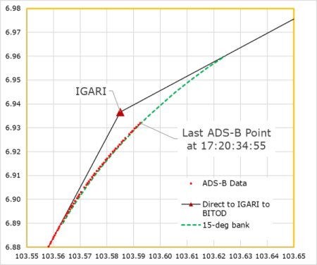
The figure below shows that the aircraft was on a track to pass over waypoint IGARI. However, before reaching IGARI, the aircraft began to turn towards waypoint BITOD. The radius of the turn indicates that the bank angle was around 15°. The start of the turn before reaching the waypoint and the bank angle are both consistent with the aircraft following an automated route in “LNAV” mode in which the flight computers were programmed to fly “direct” to IGARI and then to BITOD. (IGARI is a compulsory “flyby” waypoint.) This suggests that at the time the transponder was disabled after 17:20:34.55, the autopilot was still engaged and the aircraft was flying in accordance with the flight plan. (The Safety Investigation Report states that the Mode S symbol dropped off the radar display at 17:20:36, which is close in timing to the last ADS-B point.) This is evidence that the deviation from the flight plan occurred after the transponder was disabled.
Comparison with Military Radar Data
The radar data that we have after the transponder was disabled consists of “primary surveillance radar” (PSR) data from civilian and military sources. Although the civilian radar data sets from the Kota Bharu and Butterworth radar sites have become available through unofficial channels, the range of the civilian primary radar sites is much less than the military primary radar sites, so that after the transponder was disabled near IGARI, only military radar captured the turnback to Malaysia. (The range of the Kota Bharu ATC radar is nominally 60 NM. IGARI is about 90 NM from Kota Bharu, and therefore not visible to the Kota Bharu ATC radar.)
Unfortunately, after many requests, the raw military data of MH370 has never been released by the Malaysian authorities. What we do have are low resolution images from official reports that depict the path of the aircraft. We also have filtered speed and track data that has been digitized from graphical data presented in a report from Australian authorities. Neither of these data sets provides the level of resolution and accuracy that would allow us to independently study the details of the path after passing IGARI, including the details of the turnback.
The figure below shows the military radar data (fuzzy yellow line) that was officially released in a low-resolution image, and enlarged here to show the path near IGARI. In the image, the bulls-eye was labeled “Last secondary radar data 1722”. For reference, the waypoints IGARI and BITOD were added to the image, as well as the ADS-B data (red) and the IGARI-BITOD route leg (black). The box (orange) around IGARI represents the much smaller area shown in the previous image.
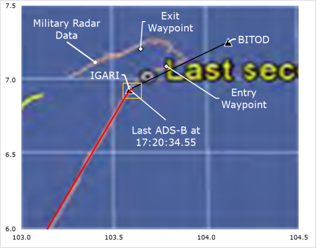
There are some obvious discrepancies between the military data shown above and the ADS-B data shown in the previous figure. For one, the military data shows the turn towards BITOD starting after passing over IGARI. This “flyover” of IGARI is not consistent with how an aircraft following an automated path during the cruise part of the flight would turn between waypoints. If this path was actually flown, it would suggest that the navigational mode was not LNAV near IGARI.
The location of the last ATC radar point (the bulls-eye) is also different in this image from what the ADS-B data suggests. The ADS-B data shows that the transponder was disabled when MH370 was abeam IGARI. However, the image above shows the last ATC radar point occurring after the turn towards BITOD was completed. This could be because what is shown was extrapolated from the final transponder reply in what is referred to as “coasting”.
The military data also shows an impossibly sharp turn to the left occurred. Despite numerous requests, Malaysian officials have never provided an explanation for the false depiction of this turn.
These discrepancies indicate that the military data near the turnback should be used with caution. It’s possible that the radar installation that captured the turnback was Western Hill on Penang Island, and the turnback was near the maximum range of the radar site. (IGARI is about 220 NM from Western Hill.) If so, the inaccuracies might be from limitations of the military radar coverage this area. As such, the path depicted in the image may have been extrapolated from missing or inaccurate data, and should be assigned an appropriate level of uncertainty.
Finally, shown in the figure are the “entry and exit waypoints” of the turn that were supplied by the military and used by Malaysian safety investigators to study how the aircraft was flown after IGARI. As described in the Safety Investigation Report, simulations performed by the Malaysian investigative team matched the timing and position of the entry and exit waypoints of the turn only when the aircraft was manually flown with a steep bank angle of around 35°. However, considering the suspected inaccuracies in the military data, the conclusion that the turnback was manually flown should be re-visited. For instance, if the turn was begun prior to the entry waypoint, it would be possible to reach the exit waypoint at the proper time with a bank angle of 25°, which is a selectable bank angle when either of the autopilot modes “Heading Select” or “Track Select” is chosen.
Timing of Events Near IGARI
According to the Safety Investigation Report, the final radio transmission from MH370 occurred at 17:19:30. The following list shows the timing of this event along with the timing of the last three ADS-B points:
17:19:30 Last radio transmission (“Good night Malaysian Three Seven Zero”)
17:20:33.61 Last ADS-B point with altitude reported
17:20:34.15 First ADS-B point with no altitude reported
17:20:34.55 Last ADS-B point, no altitude reported
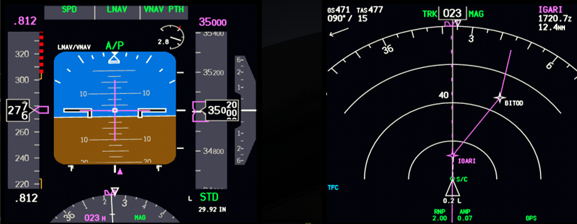
In a Boeing 777, the transponder may be disabled in the cockpit with a mode selector switch located on the pedestal between the left and right seats. The selector switch for the transponder, shown below with the label (1), would be set to standby (STBY):
During the time that the transponder was operating with altitudes reported, it was either in the switch position designated “TA/RA” for full functionality, or “TA ONLY” to suppress Resolution Alerts, or “ALT ON” to suppress both Traffic and Resolution Advisories. (TAs and RAs are part of the aircraft’s traffic collision avoidance system.) In order to select STBY from one of these three positions, it’s required to pass the intermediary position labeled “ALT OFF”. In this position, the transponder is replying to interrogations and is transmitting ADS-B data. However, there is no altitude data included in the replies and broadcasts.
Looking at the final ADS-B messages, we see that the altitude is missing for the last two messages, spanning a time of less than one-half of a second. This could mean that the intermediate switch position ALT OFF was captured as the selector switch was rotated to the standby position.
The time interval between the last radio transmission from the crew and the first message with no altitude reporting is 64 seconds. If the diversion from the flight path was caused by a third party forcing their way into the cockpit and taking control, those events would have to have occurred in 64 seconds or less. It is very unlikely that this could have been achieved by a third party in such a short amount of time.
Summary
New tracking data that has only recently become available gives us new insights as to how MH370 was flown before it disappeared from ATC radar:
- At the time the transponder was disabled near IGARI, the ADS-B data shows a path that is consistent with normal automated flight in LNAV mode following a programmed route from IGARI to BITOD.
- Discrepancies near IGARI between the ADS-B data and the military radar data suggest that the radar data has inaccuracies possibly because of the range limits of the radar installation on Western Hill on Penang Island.
- The Malaysian investigators’ conclusion that the turnback after IGARI was manually flown should be re-visited in light of the demonstrated limited accuracy of the military radar data near IGARI.
- The final ADS-B points may have captured an intermediate switch position as the transponder’s selector switch was rotated towards the standby position.
- After the last radio transmission from MH370, the maximum time available to disable the transponder and divert the aircraft was 64 seconds. That leaves an impractically small amount of time for a third party to enter the cockpit and take control.
We now have better ADS-B data for understanding how MH370 was flown up to the point that the transponder was disabled at 17:20:35. This complements the primary radar data from Kota Bharu that starts at 17:30:33. However, we are still missing the military radar data that would cover the 10-minute gap between these two data sets. That gap includes the left turn at the start of the diversion that put MH370 on a course back over Malaysia.
It is important for Malaysia to release this closely-held military radar data so that other investigators that are working to solve this mystery can perform independent analyses of how the aircraft was flown during the turn back to Malaysia. Whatever strategic reasons there might have originally been for withholding the military data are no longer relevant more than 5 years after the disappearance.
Fellow IG members Mike Exner and Don Thompson have provided valuable comments to this article.
@Andrew, Victor. I note that the crew in the Lion penultimate flight were able to switch the trim off twice, albeit perhaps in different circumstances.
@Victor,
Excellent news and report. I’d like to add a small point:
… a third party forcing their way into the cockpit and taking control, those events would have to have occurred in 64 seconds or less. It is very unlikely that this could have been achieved by a third party in such a short amount of time.
Presumably, irrespective of the happy coincidence of timing, a third party forcing his way into the cockpit could only do so without creating a substantial disturbance if he had been waiting outside the cockpit door for a pilot or co-pilot to come out for a comfort break. Doesn’t the door have a security viewer, such that even this could only occur if the PNF didn’t bother to check for someone lurking outside before opening it? Or, said hijacker was known or invited in. Only those, I think, offer good explanations for the precise timing. Otherwise, a break-in would be required, and that, surely, would allow time for a Mayday call?
Even then, is the PF going to correctly and immediately disable the transponder for the convenience of a hijacker, unless said hijacker knew exactly what was required and very specifically ordered it? Otherwise, any sane pilot would leave it on.
If I was an average hijacker, I’d want to get settled in first, and make sure that no one “touched anything” until that time. As you say, disabling the transponder must have been the first action taken, and what kind of hijacker is going to worry about that in the first <63 seconds? Only someone who knows modern passenger aviation systems very well and probably has no need to contemplate hijacking a plane, unless there is very big money involved.
A "military style" operation / heist could have done it. But then, there's airport security and passenger screening to get around as well. For that, we'd need Hollywood, or a good CT!
Do we yet know what the undeclared cargo actually was?
@Victor
Thank you for the new higher resolution data at IGARI. Your presentation is concise and excellent, and I see no further comment on the details.
Seems to me the perpetrator accomplished something special: completing the U-turn within Malaysian military radar coverage, such that the radar system was fooled to not sound an intruding flight alarm. Unlikely a 3rd party hijacker would be able to take over cockpit and conduct such an intricate manuever in 64 secs or less.
Also unlikely that emergency response to a fire or other mechanical event would create a U-turn with those special properties. In combination with your recent report on the Penang fly-by, it seems obvious the most likely pilot was ZS.
Even the ZS supporter, airline pilot Juanda Ismail, noticed that MH370’s crossing of the ILS approach to Penang occurs at a similar location and similar intercept angle to what would be flown in the course reversal procedure for ILS04. Which he thinks therefore suggests expert pilot ZS is in the cockpit to Penang.
So the military radar data is sensitive to Malaysia because: (1) it shows how to outsmart Malaysia radar, and even though Malaysia might have fixed that loophole by now, (2) it also shows whoever was flying MH370 knew how to outsmart Malaysian military radar. The latter contradicts Malaysia’s denial that ZS or equivlent experienced pilot (are they missing any other expert pilots?) took the aircraft.
i am 99% suspiciously The plane want to RTB, but cannot make it, a long time ago, many media sosial, i wrote and suggested to find from last signal military radar, around above Banda Aceh – Andaman Sea and Islands, but no one search to that location until now, And They searched near Australia, i don’t know, what’s radar detected near Australia ?? If the Pilot want to go to Australia, why was not turn right, go down then straight to Australia ?? instead of turn left, go around near Banda Aceh go down then straight to Australia, wasn’t too far ? and some debris was found on Reunion Islands, slash to Banda Aceh… i speechless on that day, all big searching was focusing to near Australia … shook my head
…..
@Victor, @TBill
So, someone with intricate knowledge of Western Hill PSR coverage at FL350 was required.
Other than someone in the military, that could only have been accurately deduced by a “local” over a long period of time.
I think it helps explain why FL350 was request at “clearance delivery”, even though FL330 had been planned and filed.
@Victor
RE: “Peter Lemme was issued a subpoena by a grand jury…”
Yes, it was mentioned in The Seattle Times a few days ago:
Grand jury subpoena shows sweep of criminal probe into Boeing’s 737 MAX certification
Excellent report, I would like to see the power supply wiring schematic, for this device, and the boot up sequence. It is possible that it affects the information content.
@DennisW
RE: ‘I agree that the 737 Max is not “unstable”, but it might be “uncontrollable” which is a more severe condition IMO…In the case of the Max there are indications that perhaps a combination of circumstances can result in an uncontrollable state – that is a state where the pilots have few or no available means of recovery.’
I agree. As I mentioned previously, it seems the flight path must first be stabilised by using the electric trim to countermand the MCAS inputs, before the trim is deactivated via the cutout switches. The manual trim can then be used to trim the stabiliser as required. However, recovery might not be possible if MCAS is allowed to move the stabiliser to a significant nose low position before the cutout switches are selected, particularly at low altitude. That last point was not mentioned in Boeing’s FCOM Bulletin or the FAA’s Emergency Airworthiness Directive.
@oddball
RE: ‘Are you saying this quote from the Intelligencer article is false?
“Because the FAA deemed the 737 Max too unstable to be used as a passenger aircraft, Boeing came up with an automated system…”’
That statement sensationalises the extent of the problem. The 737 MAX engines tend to destabilise the aircraft while manoeuvring at high AOA, making it less stable, which is not allowed by the regulations. However, less stable is not the same as unstable. The following article has a good explanation:
https://leehamnews.com/2019/02/08/bjorns-corner-pitch-stability-part-9/#more-29378
@DennisW
In my earlier post I said “the flight path must first be stabilised…”. I should have said “the control column forces must first be neutralised…”.
The sentence should read:
“As I mentioned previously, it seems the control column forces must first be neutralised by using the electric trim to countermand the MCAS inputs, before the trim is deactivated via the cutout switches.”
Reuters:
Ethiopian crew followed procedures: first official crash report
The press have been briefed, but the report does not appear to have been published online.
@Andrew
‘The press have been briefed, but the report does not appear to have been published online.‘
No, very disappointing. The Ethiopian authorities are not doing themselves any favours with all this shilly-shallying.
They’ve got until next Tuesday to get the preliminary report out to accord with ICAO’s recommended timeframe. Rather than having airline and foreign ministry officials raising expectations around an early release date they would have been far better served by quietly and diligently working towards having the completed preliminary report finalised and released next week.
Frankly, having some official say that the crew followed procedures is a little hollow until we see the FDR data and hopefully some of the CVR transcript. As Tom Sawyer said to the boy, ‘Well your saying so don’t make it so.’
Just as importantly, what triggered MCAS this time around?
And while we’re on preliminary reports, where’s the NTSB’s preliminary for the Atlas B767 crash?
https://www.bbc.co.uk/news/business-47812225. No official report released yet
@Victor. I’ve yet to read your new blog above. I’m looking forward to it. Thank you for your continuing efforts to discover the truth about MH370.
@oddball. Thank you for replying to my posts!
Concerning the 737 MAX. Peter Lemme has noted that the function of the 737 stablizer trim switches changed between the NG design and the MAX design. Close comnparison of the STAB TRIM switches on NG vs MAX aisle stand shows the difference in nomenclature on the switches.
On the MAX the STAB TRIM cut-out switches are labelled PRI (left switch) and B/U (right switch).
On the NG and Classic series the STAB TRIM cut-out switches are labelled MAIN ELEC (left switch) and AUTO PILOT (right switch).
My interpretation supported by FCOM description is that, on a NG/Classic aircraft, the AUTO PILOT (that is the AFDS Flight Control Computer) may be isolated/cut-out from commanding powered stablizer drive while still enabling pilot command over powered stab drive using their control wheel thumb-switches.
Whereas the MAX is quite different. The STAB TRIM switches on the MAX only permit stab trim command from either or both Flight Control Computers (PRI or/and B/U) to be isolated/cut-out.
My assumption for the MAX operations is that both PRI and B/U STAB TRIM switches must be switched to cut-out so as to fallback to manual winding of the STAB TRIM wheel. There is no interim fall back that isolates FCC trim drive while retaining powered control wheel stabiliser trim commands by the pilot.
Boeing’s Nov 6, 2018 FCOM Bulletin states “Manual stabilizer trim can be used after the STAB TRIM CUTOUT switches are moved to CUTOUT. Note that this sentence states ‘switches‘.
This change in stab trim cut-out behaviour must have been a significant contributing factor in how the pilots evaluated and reacted to the situation. If it was that the LNI or ETH pilot simply reached down and selected the right switch to cut-out, expecting (from his NG memory) CUT-OUT of the AUTO PILOT (FCC) trimming command he would have been surprised that automatic trim continued. Ergo, confusion is seeded.
@Victor Have now read your latest blog.
I did not know that the transponder could be turned off in the cockpit by the method you describe. Would the co pilot be aware it was being turned off at the time or later would he notice? I am assuming the co pilot ought to be aware of even the minutest of changes to the electrical system.
I think you and others are saying that the reason the Malaysian authorities will not release some of the military radar data is most likely because it’s not accurate (& therefore shame involved) and not because they know the data reveals facts that they do not want the world to know.
@Ventus45 @Victor
“…So, someone with intricate knowledge of Western Hill PSR coverage at FL350 was required….I think it helps explain why FL350 was request at “clearance delivery”, even though FL330 had been planned and filed….”
Thank you for bringing that altitude change to my attention. Yes I am also fixated on the higher altitude as an intentional maneuver for radar line-of-sight to keep visible on the radar.
An alternate explanation of Victor’s observation that the altitude reporting was OFF for the last two ADS-B points, is that the aircraft was possibly starting climb at IGARI so the pilot switched the transponder to ALT OFF. I would like to know the time-stamp of the “Entry Waypoint” to see if there is slow down due to ascent. Not sure why the pilot wanted to paint the radar with altitude-less points to IGARI but we can imagine maybe the co-pilot made a speedy exit from the cockpit, and ZS was immediately free to make his move.
@ventus45: Why would a higher flight level be desirable if the objective was to hide the turnback after IGARI?
The last ADS-B point is approximately 1 second after MH370 passed abeam of IGARI. If one were viewing the CDU ACT RTE LEGS page, my understanding is that the IGARI waypoint would have just scrolled off the top of the screen.
@sk999: Exactly. My guess is that the transponder was switched off just as BITOD became the active waypoint on the legs page as well as on the navigational display.
Thank you, Victor and contributors for an excellent post. A few quick observations and questions.
1. A 15 degree bank turn from 027 to 058 at ~480kt TAS should take about 36 seconds. The aircraft was a little over half way through this turn at the time this datastream ceases, with no indication at that point that the turn was anything but ongoing as planned. About 16s later it would have completed the turn on to 058/059 on the IGARI-BITOD leg.
2. Would the datastream described above indicate if any of the following had occurred: change in navigation mode, disengagement of A/P, change in commanded speed, change in alt, error messages from avionics systems?
3. Can you confirm if any of the above did occur, or indeed any other sign of something being awry (other than alt=0) before the datastream ceases?
one more, if I may:
Does the datastream also give us speed readout (any of mach/TAS/CAS/GS) up to time of disappearance?
@Paul Smithson: Very good questions. I don’t know the answer. Don has been working on that. Perhaps he will comment on the status of that work.
@Julia Farrington: There would be a message appearing on the navigational displays of both the Captain and First Officer when TCAS was turned off.
Thanks @Victor. I look forward to hearing from Don. I see that the file you have shared does periodically provide velocity x/y, presumably groundspeed, which translates into 470.9kt and 471.3kt for the last two datapoints that included these fields. The preceding readings indicate a very slight reduction in GS from 474->473->472->471 that is consistent with expected increase in headwind as the track angle changes to windward.
@Paul Smithson: Yes, those speeds are ground-referenced. The groundspeed may be calculated from sqrt(Vx^2+Vy^2), and the track may be calculated from atan(Vx/Vy), or for users of Excel that wish to place the angle in the correct quadrant, atan2(Vy,Vx).
@Victor @sk999
Re: My guess is that the transponder was switched off just as BITOD became the active waypoint on the legs page as well as on the navigational display.
That is not how MicroSoft flight sim works…not sure about real B777. In FS9, the Waypoint advances exactly when the turn starts, so well ahead of Waypoint depending, on degrees of turn. I am thinking a real B777 anticipates turns a little better than flight sim, but for these gentle turns, flight sim seems pretty good match to reality.
It is interesting that ADS-B goes off abeam IGARI, but I was not thinking that is when BITOD shows up on the screen, unless there was little delay on the part of the pilot.
@TBill: In the PMDG 777 model, the transition of the active waypoint from IGARI to BITOD occurs when IGARI is almost exactly abeam, and definitely not at the start of the turn. I can’t be sure of what occurs in the real world, but I would trust the PMDG 777 model over the PSS 777 model, and it also makes more sense.
@Victor
OK I’ll check for a difference between FSX/PMDG and FS9/PSS777 when I get the chance. I just happen to have PSS777 saved case right there.
The Preliminary Report for ET302 is now available.
Many interesting things to note, including anomalous behavior while the autopilot was engaged during the initial climb.
@Victor
“The time interval between the last radio transmission from the crew and the first message with no altitude reporting is 64 seconds. If the diversion from the flight path was caused by a third party forcing their way into the cockpit and taking control, those events would have to have occurred in 64 seconds or less. It is very unlikely that this could have been achieved by a third party in such a short amount of time.”
The third-party hijacker could have been in the cockpit for some time before IGARI. He could terrorize the pilots (pilot) and force them to execute his commands. The best moment to take control over the cockpit was the period of time just after reaching the cruising level (pilot’s visit to the toilet, drinks and meals delivered to the pilots by the cabin crew). This could happen between the first report to the ATC on maintaining FL 350 and its unreasonable repetition. This second FL350 report might have been under the control of the hijacker just like the last “good night …” message. In both transmissions, the pilot could deliberately apply deviations from the communication procedure to draw ATC attention. But the way he did it suggests the hijacker’s great aeronautical knowledge. When the FMC changed the next WPT from IGARI to BITOD the hijacker started his flight plan and the crew could somehow react in defense.
This is not my favorite scenario. I do not have such. It’s just an option, like many others, which still can not be ruled out at this stage
@Greg: Yes, I suppose an earlier take-over is possible, and things were not as normal as they seemed before the transponder was disabled. The flight path and ATC exchanges seemed normal, but I understand your point.
@Andrew. “…recovery might not be possible if MCAS is allowed to move the stabiliser to a significant nose low position before the cutout switches are selected, particularly at low altitude. That last point was not mentioned in Boeing’s FCOM Bulletin or the FAA’s Emergency Airworthiness Directive.”
Does all this not have implications for earlier 737 models in the event of a trim runaway nose down at low level?
@Greg
I understand too, that is what the ZS supporters are saying, even the experienced pilot above says it sure looks like ZS was the pilot flying to Penang, so there must have been a hijacker holding him hostage. But ZS had the option to send hijack code, and why would ZS have to conduct a perfect escape that faked out Malaysian military radar coverage? There are questions about the radio transmissions and if we are getting the whole true transcript to IGARI. But I am thinking the purpose of any transcript non-disclosure was to hide the truth, which I am glad to deal with whatever the truth is.
@Victor
My postulate is basically this.
Zs knew full well, that the return over the peninsula would be visible to WH-PSR, regardless of his return path cruise altitude.
He was “only hiding” from civil ATC – and “ONLY” them, – and “NOT” from the RMAF.
Specifically, he NEEDED to remain visible to the RMAF, so that they would know it was him, and NOT a “new” PSR target.
The requirements were twofold.
First, to be “forgotten” by KL ATC after the hand-off to Ho Chi Min. (Achieved)
Second, to REMAIN VISIBLE to RMAF, at FL350, so as to make it look like an emergency turn-back.
RMAF would assume it was still in contact with KL ATC – and do nothing. (Achieved)
Remember H2O’s comment on “4 Corners” ? – “It was from our airspace”.
Now, look again at those plots I sent you yesterday.
If he had have been lower, at FL330, the plan would not have worked.
There would have been a significant time gap, since he would have dropped off the WH-PSR display minutes earlier, so by the time he would have “reappeared” on WH-PSR (post turn-back) it would have been treated by the RMAF as a “new target”, and ACTION TAKEN, which he did not want !
In other words, FL350 was vital to “put the radar operator to sleep” – so to speak.
He did.
He simply outfoxed them.
@David
RE: “Does all this not have implications for earlier 737 models in the event of a trim runaway nose down at low level?”
Quite possibly, but I think we also need to remember the B737 has been in production for over 50 years in various guises. During that period over 10,000 B737s have been delivered and the B737 family has accumulated more than 300 million flying hours. To my knowledge, older versions of the aircraft have had very few runaway stabiliser events, so the risk seems to be very low. Of course that doesn’t mean it can’t happen to an older aircraft.
Paul,
To expand on Victor’s response to your questions:
2,3,4: the ADS-B surveillance data, as do extended squitter Mode-S replies, indicates certain avionics derived states (but not error msgs). At this time, apart from the alt reverting to 0, there’s nothing apparent that helps explain anything that is about to occur as the transponder ceased. Mach, TAS, and GS are exposed, we’re continuing to extract & assemble data.
@Andrew. Airworthiness of earlier 737 models. Thanks. While the risk is demonstrably low, I would have expected the FAA to think about a re-visit for those others, that is if there is an unaddressed hypothetical now apparent which breaches certification requirements.
I think they will re-visit the problem if it is found to have been a factor in these accidents. If nothing else, I expect the issue will receive much more attention during pilot training and be prominently highlighted in the manuals.
A few observations from the ET302 Preliminary Report:
1. The L AOA output diverted to around 75° immediately after lift-off. The L stick shaker activated and remained continuously activated until the last 15 seconds of flight.
2. The Master Caution activated shortly after lift-off and the FO called “Master Caution Anti-ice”, presumably in response to illuminated Master Caution and Anti Ice lights on the system annunciator panel, located on the glareshield. This seems to have been associated with the failure of the L AOA Heat, which occurred about the same time. Later in the flight, both pilots called “left alpha vane”, probably in response to an illuminated probe heat light, located on the probe heat panel on the forward overhead panel.
3. There were several automatic nose down trim commands while the AP was engaged, which is normal AP behaviour in response to increasing speed.
4. The AP disengaged about the same time the flaps retracted, at which time the first of three large automatic nose down trim commands occurred. There was a change in pitch trim with each of the first two commands, but no change with the third.
5. The Capt responded to the first two automatic nose down trim commands by trimming nose up with the electric trim. However, the nose up trim inputs did not completely remove the previous automatic nose down inputs and he continued to hold the control column rearwards to keep the nose up.
6. The lack of trim change following the third automatic nose down input seems to indicate the STAB TRIM CUTOUT switches were selected to CUTOUT some time between the Capt’s second nose up trim input and the third automatic nose down command.
7. There were two more very brief nose up trim inputs towards the end of the flight, which seems to indicate the STAB TRIM CUTOUT switches were selected back to AUTO. The nose up trim commands had very little effect on the pitch trim.
8. The nose up trim commands were followed by a final automatic nose down command, which caused a considerable change in the pitch trim.
9. There were no further changes in pitch trim following the final nose down command. Based on Victor’s earlier comment, the STAB TRIM CUTOUT switches might subsequently have been re-selected to CUTOUT.
Further thoughts:
1. The extreme divergence of the L AOA output and failure of the L AOA heat might indicate physical damage to the L AOA vane during lift-off, possibly due to a bird strike.
2. The aircraft system responses to the L AOA output are almost identical to the JT610 accident, ie stick shaker, altitude/airspeed indication disagreements, MCAS activation.
3. The Capt did not completely remove the automatic nose down trim inputs and continued to hold the control column rearward. As previously discussed, the upward deflection of the elevator might have made manual trimming impossible, particularly at the very high speed the aircraft was flying (VMO or above) after the stab trim was deactivated. Recovery might have been possible if the speed had remained at or below 250 KIAS and not increased to VMO. However, having accelerated to such a high speed, it’s unlikely the crew could have recovered unless they climbed to a much higher altitude, which in itself might have been difficult.
@Andrew,
What’s your take on why the column cut-out switches did not arrest stabiliser movement?
@Pilatus
I haven’t flown the B737, but my understanding is the control column cut-out switches do not affect the MCAS operation. See the following PPRuNe post by FCeng84:
https://www.pprune.org/rumours-news/619272-ethiopian-airliner-down-africa-44.html#post10415935
The Seattle Times:
Ethiopian pilots fought the 737 MAX flight controls almost from takeoff, preliminary report shows
@Ventus45
RE: ‘I think it helps explain why FL350 was request at “clearance delivery”, even though FL330 had been planned and filed.’
Nice theory, but may I suggest a far less clandestine explanation? Pilots can’t always flight plan their optimum cruise levels due to agreements between the ATC providers in adjacent FIRs. Those agreements dictate the levels that an aircraft can plan to fly on a particular air route. However, that doesn’t stop a pilot from requesting an alternative level from ATC once the flight plan is in the system. If the traffic situation allows, ATC will normally accommodate such a request.
In the MH370 case, FL350 was much closer to the optimum level for the aircraft’s weight. I would suggest the pilot requested that level simply because it was more efficient than the planned level.
@Andrew
Things are not looking good for Boeing. The flight crews on the MAX crashes seem to be in the blameless category.
@Victor
I have difficulty with the IGARI radar comments and analytics. The plot of the military radar is obviously “derived” from the radar data and not at all representative of raw data. Who knows how that graphic was created?
@DennisW
I suspect the EK521 Final Report, when it is eventually released, will add fuel to the inferno.
@Victor
OK yes the PMDG777 makes the change to BITOD abeam IGARI, whereas PSS77 makes the BITOD change earlier. So yes if PMDG is true B777 behavior, then it looks like transponder was turned off the exact second BITOD was first showing active. Parenthetically, why would a fire or 3rd party hijack happen at that moment? It looks more like the pilot was focus on the screen to see the change to BITOD waypoint.
Both PMDG and PSS777 seem to overshoot the IGARI-to-BITOD line a little bit and then then they both curve gently back to the trend line, so the end of the turn is not quite as perfect as you show above. If the real B777 also overshoots a little bit, it might explain why the “entry waypoint” is a little offset from the exact line to BITOD.
@Victor. Thanks for info on the transponder.
@Don and @ Mike Exner. I should have included you both in my appreciative comments about Victor’s blog. So thank you too for your tireless efforts to understand the technical aspects of flight of MH370.
I fly regularly on the older 737’s 800 series and am always thankful when I board these days to see the engines further back (than the Max8) and looking a whole lot lighter. They may not be as fuel efficient as the max but that doesn’t concern me in the light of recent tragic events. I really wish I could contribute to this blog in technical speak and my apologies for my simplistic observations but I heard yesterday that the red light/ sensor visible on the exterior at the front of the MAX failed to correct the nose dive as it was supposed to do in the new instructions to pilots so I was lead to believe that however expert the pilots are, this fault is outside anyone’s control at the moment. What I fail to understand though is that the MAX have been flown by Norwegian Air, Tui and American without fatal crashes. However it would be interesting to know how many non fatal incidents there have been with each airline with the anti stalling mechanism.
@Andrew
@DennisW
Andrew, I suspect that the EK521 report will splash a bit of petrol up the FAA’s leg, given their steadfast refusal to do anything about autothrottle training after the Asiana 214 prang (you’ve only got to look at the history of NTSB Safety Recommendation A-14-037 to see the NTSB’s palpable frustration with the FAA). Given how close the FAA finds itself to the Boeing bonfire that’s likely to cause a bit more ‘unpleasantness’ all around.
Did you have anything specific in mind when you suggested that Boeing will cop some stick from EK521?
Dennis,
Are Boeing buying their own stock to put a floor under it? I can think of no other reason for its current gravity defying feats.
Now, if they could get the MAX to maintain altitude like that …
@Mick Gilbert: The lift in the Boeing stock price is probably related to some positive developments in US-China trade talks.
@DennisW: Many of us would like the raw military radar data so we don’t have to rely on a fuzzy line that is physically implausible. The new ADS-B data demonstrates that the path based on the military data that has been provided does not match the ADS-B data near IGARI, which calls into question the accuracy of the military data during the time interval when no other source of data exists.
@Andrew: I was not aware that the AoA sensor that is used to trigger MCAS alternates from left to right for each flight. That means that one flight that experiences a speed and altitude disagreement due to a faulty AoA reading might result in erroneous triggering of MCAS on the next one. I’m not sure of the logic behind that design choice as it would make troubleshooting more difficult.
@Mick
I am also surprised by the BA stock performance. I would not touch the stuff.
https://articles.marketrealist.com/2019/04/analysts-stay-bullish-on-boeing-amid-737-max-crisis/
@All – Question
In the case of MH17, the passenger oxygen system has not been activated.
„While the sudden depressurisation of the fuselage should have triggered the deployment of masks, the inquiry found that this was prevented by the loss of electrical power.”(FlightGlobal)
Does anyone know how the B777 pax-ox system is powered and controlled?
It is obvious that a system based on chemical generators can not be manually turned off or blocked.
Is the deployment of oxygen masks the only indicator of depressurisation for passengers and cabin crew (disregarding physical sensations)?
@Greg
Very good question re: O2 masks.
So far MH370 discussions have said there is no cockpit control over the O2 mask drop down, but there are circuit breakers in MEC Bay.
I don’t know if it might be possible for the pilot to disable the O2 masks by manually cutting all power to Left and Right buses.
My personal theory is that the pilot would have wanted to suppress the O2 masks, because if intercepted, he would not want the fighter pilots to see the “spaghetti”. I am thinking all power may be off around IGARI to stop black box data recortding as well as O2 masks (if that is possible).
Can the FDR and CVR be disabled?
If that’s the case, even if they are found, there wouldn’t be anything useful on them to solve the mystery…
@ArthurC
My understanding yes the Black Boxes can be cut off, by circuit breakers in the MEC Bay, or by cutting off electric circuits in the cockpit, which is what I am thinking.
But to paraphrase legendary crash expert Greg Feith, even if the black boxes were disabled, it will be interesting and valuable data.
@Victor
RE: “That means that one flight that experiences a speed and altitude disagreement due to a faulty AoA reading might result in erroneous triggering of MCAS on the next one. “
Yes, I assume the speed/altitude disagreements would occur on successive flights due to the difference between the two AOA outputs, but erroneous MCAS activation would only occur on alternating flights where MCAS is using the faulty AOA output. The 737 MAX Onboard Maintenance System can probably determine which sensor is erroneous, depending on the fault.
@Greg
@TBill
RE: “Does anyone know how the B777 pax-ox system is powered and controlled?”
There are two conditions that will cause the release of the passenger oxygen masks:
– The passenger oxygen switch on the overhead panel in the cockpit is selected to ON, or
– Two of three cabin pressure sensors indicate the cabin pressure altitude is above 13,500 ft while the aircraft is airborne with an airspeed of more than 80 knots.
If either of those conditions occurs, a relay in the standby power management panel activates the latches on the passenger oxygen boxes and the oxygen masks are released. The system needs 115V AC power from the AC Standby Bus and 28V DC power from the Capt Flt Inst Bus to operate. The chemical oxygen generators do not start producing oxygen until a passenger or crew member pulls on an associated oxygen mask.
Several other events occur in the passenger compartment when the oxygen system is activated:
– Aural alert
– Passenger compartment lights illuminate full bright
– No Smoking and Fasten Seat Belt signs illuminate
– PA volume increases to maximum
In the MH17 case, the destruction of the forward part of the fuselage would have caused the immediate loss of electrical power and rendered the passenger oxygen system inoperative.
Manual deployment of the passenger oxygen masks can be initiated from the cockpit, but automatic deployment cannot be prevented.
Thanks Andrew,
That’s interesting. This is the first time I’ve considered that the pax O2 system may have failed as it’s powered from the AC stby bus.
As I believe that bus was taken out by a rupturing O2 bottle that now means the pax never had any drop down O2 after the decompression.
And am I the only one on this site who does no support a nefarious pilot?
@Victor
@Mick Gilbert: The lift in the Boeing stock price is probably related to some positive developments in US-China trade talks.
Analysts make the trade talk claim. However, just for fun I did a dscounted cash flow calculation (I have it automated in Goggle Sheets), and came up with ~$600/share. The company “has been” generating an enormous amount of cash. Certainly the 737MAX events will impact that cash flow, but it is anyone’s guess how much or for how long. Based on historical financials the company is significantly undervalued at ~$400/share. At $400/share the $8.22/share dividend represents ~2% which is better than leaving your money in a bank.
Still, you can stick solar panels on your roof and get an 8% risk free rate of return (in Cali), and feel pious about it. Maybe I am too risk averse in the winter of my years.
@Tim
And am I the only one on this site who does no support a nefarious pilot?
As far as I know.
Off site, the Malaysian Transport Minister sympathizes with your position, but I think he is motivated by liabilty concerns. Are you with Alianz SE?
@Tim: I think most here believe a deliberate diversion is by far most likely, but last I checked you have @Mick Gilbert in your corner on favoring an accident scenario.
RE: “Does anyone know how the B777 pax-ox system is powered and controlled?”
@Andrew
@TBill
Thank You for response
@Andrew
If I have understood correctly, these 4 events occur as part of system activation. Are there any events indicating depressurisation independent of automatic deployment? Will any events occur if only one of the electrical power sources is lost: 115 AC or 28 DC?
@Tim
I do not support anything, the matter is open.
@Andrew
Routine request for “optimum altitude” for the weight is noted, but it still seems to me that FL350 was “required” for the seduction of the RMAF, “if” ZS really was the perp.
@Tim
“And am I the only one on this site who does no support a nefarious pilot ?”
I still feel that a genuine emergency is an “outside chance”.
One of my original theories, was based on crew O2 bottle failure/rupture, with hull rupture, and an attempted turn-back/return to KL via UPRON (recently overflown), but, like in the CALI disaster, with UPROB being selected in error, with crew incapacitation soon after.
https://auntypru.com/forum/showthread.php?tid=28&pid=4646#pid4646
@Tim you can put me down for that under-populated corner too.
The 737 has a large manual trim wheel on both sides of the center console. My understanding is that it takes about 250 turns to move the stabilizer through its full 17 degree range. It has a pull out handle if the trim needs to be changed rapidly – smaller changes can be made by just pushing or pulling the top of the wheel. The mechanical advantage is huge, so it is easy for the pilot to just grab the wheel and stall the electric trim motor. This trips MCAS off – at least temporarily. Beeping the column electric trim also disengages the motor, at least temporarily.
On 302 it looks as if the pilots toggled both the autopilot and manual electric trim buttons off. They are used to using the yoke buttons to trim the aircraft. When these are used the manual wheels spin like fans. It seems that the crew couldn’t move the manual trim wheel fast enough to bring the nose up and maybe didn’t pull out the handle and turn like crazy. They turned both of the electric trim toggles back on. I think if they only used the left toggle (trim button) it might have been OK. I think MCAS goes with the autopilot by way of the right toggle. But they are instructed to turn off both toggles by Boeing. They apparently needed the high speed electric trim column buttons to get the nose up and this allowed MCAS to engage and push it down at the end.
The FDR showed that when the flaps were retracted at 05:40:00 there was a FCC (MCAS) nose down trim causing pitch down and a second FCC pitch down at 05:40:21. There was a FCC command at 05:40:42 but no pitch change because toggle may have been turned off just before. But there was no electric trim and pitch trim was flat until 05:42:49 when the toggles may have been reengaged. It is surprising that the trim was not changed manually from 05:40:45 to 05:43:21 when FCC/MCAS engaged. Maybe it was too slow, but trim never change even slightly – but 2 seconds is not a lot of time to figure it out. They never recovered after the last MCAS engagement and pitch attitude just plunged.
I think that switching the right (FCC) toggle disconnects the FCC/MCAS input to the trim motor. The left toggle I think cuts out the yoke switches, which may be needed for a runaway trim, but maybe should have been reengaged without the A/P toggle. Maybe Boeing should have encouraged engaging the left toggle.
@Tim
“And am I the only one on this site who does no support a nefarious pilot?”
I’m among those here who prefer to leave all options open until we have more complete and accurate information available.
Here is a link to a pdf listing the main expressions used in my path reconstruction tool.
https://www.dropbox.com/s/u4hwmboa1wfcxnb/WGS84PathModel4.pdf?dl=0
Comments, questions and suggestions are welcomed. I intend to implement the model in Matlab (now calculations are carried out in Excel) as it would help to automate certain procedures needed for estimation of possible “error range”.
@Hank,
I wrote a comment earlier concerning the STAB TRIM cut-out switches.
Do check your interpretation against the nomenclature on the switches on NG series aircraft vs MAX series aircraft.
The MAX the STAB TRIM cut-out switches are labelled PRI (left switch) and B/U (right switch).
The NG and Classic series the STAB TRIM cut-out switches are labelled MAIN ELEC (left switch) and AUTO PILOT (right switch).
The MAX switch operation does not appear to allow the control wheel switches to command trim while the autopilot is isolated.
@Tim
‘And am I the only one on this site who does no support a nefarious pilot?‘
I’m not a fan of this notion of ‘camps’ or ‘corners’. That sort of binary thinking generates a lot heat but does little by way of advancing the discussion. All it does is entrench thinking more firmly.
I’ve never said that it wasn’t deliberate malicious action, it may well have been. But it may not have been deliberate malicious action. I try to maintain an open mind on the matter.
Someone (I thought it was Norman Augustine but haven’t been able to find a proper attribution) once said something to the effect that,
‘As aircraft complexity increases, so too the cause of aircraft accidents will become more complex but at no point will an accident be so complex that it couldn’t be blamed on the pilot.’
@Don Thompson
I checked and you are correct. The labels are different. There was some value in being able to separately disengage the yoke trim buttons versus the FCC. I saw a wiring diagram for earlier 737 and it looked like the yoke buttons were routed through one and the A/P by the other. I suppose two buttons in series ensures cutoff. Maybe Boeing figured the A/P could be switched off and not need a switch. Not true for MCAS. I don’t suppose Boeing told NG pilots about the change?
@Mick
A saying often attributed to Mark Twain – “Climate is what you predict. Weather is what you get.”
To the people here who insist on remaining open – don’t pursue a career as a meterologist. You won’t get by with telling me you don’t have an opinion about the weather because of the complexities.
When my boss would ask for a quarterly revenue forecast I could not get by with – “I don’t know, a lot of things could happen”. FWIW I think I have an open mind as well, but that does not rule out having an opinion and expressing it.
@Andrew
Re: O2 Masks
Thank you…sounds like you are saying there are not even MEC Bay circuit breakers that could stop the O2 mask drop down.
@Ventus45 @Tim
I am not sure MH370 composite O2 cylinders have much potential for rupture, but even if it did, I presume the cylinder hold down brackets are robust enough to prevent the cylinder from becoming a projectile/missile, which is the main problem. Presumably the historic Qantas failure (which was a metal style cylinder) was really two failures in one: defective cylinder and poor design of cylinder brackets?
@DennisW
When my boss would ask for a quarterly revenue forecast I could not get by with – “I don’t know, a lot of things could happen”.
Dennis,
I’m sure you could not, and neither could I under not dissimilar circumstances.
The difference, of course, was that in those previous roles we generally had a reasonable sufficiency of fit-for-purpose information such that we could make those quarterly revenue forecasts or similar within the accepted bounds of accuracy. And, generally speaking, we’d be presenting such forecasts as a range with some sensitivity analysis thrown in so as to provide as complete a picture as possible. We weren’t saying ‘I don’t know‘ but we were (or should have been) saying ‘a lot of things could happen‘ and here’s how they will impact the forecast if they do. That was certainly the generally accepted way of doing things in my world, anyway.
I have no problem wading in and expressing my opinion when and as required (and sometimes when it’s not required). What tends to get on my goat are the sweeping unconditionally declarative statements (the ‘it must have been this‘, ‘it could only be that‘ or ‘this proves that‘ stuff) when the evidence that underpins them is conjectural. On that stuff, I will wade in. But after five years of this, frankly, my approach now is that if the discussion has no bearing on refining a search strategy, then I’m more likely to save my keystrokes.
@Greg
RE: “If I have understood correctly, these 4 events occur as part of system activation. Are there any events indicating depressurisation independent of automatic deployment? Will any events occur if only one of the electrical power sources is lost: 115 AC or 28 DC?”
Yes, when the deployment relays energise due to either cabin alt >13,500 ft or passenger oxygen switch on, the electrical load management system (ELMS) sends a signal to the cabin services system (CSS), causing those four events. There are no other system events to alert the cabin crew about a depressurisation.
The four system events are controlled by the CSS, which has many different interfaces and power sources for different parts of the system. I haven’t had time to check what, if anything, would be affected by a power loss, but most emergency-related systems are powered via the standby electrical system. The standby system has a huge amount of redundancy, including the main battery, which can also power a standby inverter fo AC power. The four events probably wouldn’t be affected unless there was a massive power loss. The passenger oxygen system itself is also powered by the standby electrical system and would not be affected by anything other than a massive failure.
@TBill
RE: “…sounds like you are saying there are not even MEC Bay circuit breakers that could stop the O2 mask drop down.”
The functional description in the AMM/Training Manual does show breakers for the passenger oxygen system in the MEC. There are two channels (A & B) for redundancy. Each channel uses 28V DC to control its respective oxygen deployment relay and 115V AC to unlatch the passenger oxygen boxes, four circuit breakers in total.
@Mick
Well said above.
RE: “Did you have anything specific in mind when you suggested that Boeing will cop some stick from EK521?”
It seems the cause will ultimately come down to a failure to increase thrust during the go-around. HOWEVER, in my view there are significant documentation and training deficiencies related to the TO/GA inhibit function that were no fault of the crew.
The B777 FCOM go-around procedure is a generic procedure that is meant to cover go-arounds before and after touchdown. The problem, however, is that the automation behaves quite differently in the go-around after touchdown case and the pilot MUST, amongst other things, manually advance the thrust levers to set the required thrust.
To this day, the differences between the two go-around cases are not highlighted in the standard go-around procedure. The company where I work recognised this hazard over 15 years ago and developed a rejected landing procedure for the go-around after touchdown case. The issue was discussed with Boeing and I believe Boeing issued a notice of ‘No Technical Objection’ at the time. The rejected landing procedure is included in our FCOM and our B777 pilots receive periodic training in the simulator; however, the procedure is not included in the standard Boeing FCOM. Discussions with other airlines’ B777 pilots following the EK521 accident showed that many were not aware of the TO/GA mode inhibit and had never received training for a rejected landing.
@Mick Gilbert
My previous comment was for you!
@Andrew
Yes, got it, thank you.
That is interesting that Boeing don’t differentiate between the two go-around cases despite the fact that their software treats the two cases differently. I’m mean it’s not as though anyone was looking to save paper when they wrote the B777 FCOM. Even more interesting that not all operators were aware of the difference. You would think that Boeing might have seen fit to share the procedure that your airline developed with other operators.
There seems to be an element of ‘“written in stone” never to amended‘ to some of Boeing’s decision making.
@Mick Gilbert
I think it comes back to Boeing’s philosophy that automation is a tool that assists, but doesn’t replace the pilot. Consequently, Boeing’s procedural design very much relies on pilots doing what pilots are supposed to do, ie FLY THE AIRCRAFT. That’s well and good, but in the real world pilots are becoming more and more reliant on automation and when the automation does something unexpected, pilots are sometimes caught out. There is a case for pilots to be given far more manual handling practice with all the automation turned off, but some airlines are loath to allow it during line flying and insist on the maximum use of automation wherever possible.
@Andrew
Yes, it is becoming apparent that rather than there being a ‘shared’ view that the pilots and the aircraft are part of one integrated system there’s almost a dichotomous mindset at both the airlines and the manufacturer(s). There seems to be a view that the safe and effective operation of the aircraft is managed either by the application of automation or by the application of flight crew skills. The more of one, ostensibly the less is required of the other.
And given that there are costs associated with each side of that equation that are born by either party – the manufacturers for aircraft systems and the airlines for training – there’s an underlying incentive to try and kick ‘problems’ over the fence. As Charlie Munger says ‘Show me the incentive and I’ll show you the outcome‘.
This whole MCAS mess is perhaps as good example of this. Boeing seemed to take the approach that they could kick the issue of dealing with the deficiencies of their system over the fence to the airlines/flight crews to deal with; their approach was ‘Well, if there’s an erroneous activation then the flight crew will catch this‘. To my mind, had there have been an ‘integrated systems‘ approach you would have seen far, far better modelling and simulation of erroneous MCAS activations and far, far better testing of the ‘the flight crew will catch this‘ assumption.
The fact that Boeing were obviously motivated to keep (publicised) differences between the MAX and the NG to a minimum clearly didn’t help. In fact, it almost guaranteed that there would be no open discourse between Boeing and the airlines on the topic. Good old Charlie
incentive » outcome.
@Mick Gilbert
I don’t think that Boeing sees it as ‘kicking deficiencies over the fence’. Under the Boeing philosophy, the pilot is ultimately in charge, not the automation. Accordingly, if something goes wrong or doesn’t go to plan, the pilot is expected to take the appropriate action to save the day, ie FLY THE AIRCRAFT. However, that assumption relies upon pilots having a good understanding of their aircraft and knowing what to do. Those conditions are difficult to satisfy when the documentation and/or training is deficient.
@all
Does anyone find Boeing’s responses to 777 and 737 Max an interesting comparison. In each case 2 planes were lost. Boeing immediately apologized for the 737 and is working to correct the software. Boeing obviously concluded that no such situation existed with the 777. It would seem Boeing would at least make a public statement. MH17 was shot down. What did Boeing conclude about the MH370? I would certainly feel more comfortable if I knew that Boeing had addressed some of the scenarios identified in various blog posts. Maybe lock or alarm the the e/e bay access. Reconfigure the auto transmitters for water landing. Extend the battery life and power for black boxes. Require location information for sat transissions. Require responses for pax background checks. Have “always on” transponders. Etc. Boeing’s response to MH370 indicates they felt whatever happened was man made and did not require any public acknowledgement. Maybe they have already made some of these changes. And maybe they already know the cause.
@Trip
Yes definitely I see parallel to MH370. In the case of MH370 it is not a design flaw but error of omission letting pilot turn off transponder secretly, etc. Three 9/11 planes did that too. One wonders if NTSB is sugar coating the Atlas Air accident to avoid saying intentional grounding in that case.
I do not think Boeing wanted the public to understand MH370, because then the public would be asking, why do we still do that? Now Boeing is going to be more vulnerable, previously they could say- our safety record puts us above even having to listen to what any critics say. And I suspect Airbus will be more responsive to MH370 cockpit security concerns.
All of the MH370 conspiracy theorists, media mystery hypers, and hijacking naysayers have greatly aided obscuring the apparent truth of MH370 from the public. So Boeing is off the hook there. That’s why I liked last years Aussie 60 Minutes show, it told it like it should be told (though we can debate LVance content as usual). We did not get that show in the USA (and I asked USA 60 Minutes for it).
@Andrew & @Mick
“Under the Boeing philosophy, the pilot is ultimately in charge, not the automation.”
Naturally, Boeing’s input for the ‘state of the art’ in pilot skills to their designs will be solicited from the senior, highly experienced, echelons of customer airlines. What if the training intake is not being selected for the same qualities as the senior, experienced, pilots?
@All
In case anyone’s interested in checking out my ms on finding MH370 via water chemical analysis, I’ve moved it from dreary Dropbox to Google Docs. Here are the first three paras.
Abstract: An accelerator mass spectrometer (AMS), has a sensitivity of 1/10^15 = 1g/km^3 (1). I estimate the production rate of aluminum alloy solutes for the MH370 site at the present time to be ~2.1kg/day. Deep ocean currents convey such solutes somewhat unidirectionally, and higher solute densities limit upward spreading. A typical current flow of 5cm/s will carry the solute 4.3km in one day, and reasonable assumptions indicate that during that time the solute will be confined to a volume of ~6.7 km^3, thus producing a solute density of 320g/km^3 = 320/10^15,clearly within the working range of an AMS. 5 ROVs, searching 2.1km abreast at 8km/hr, could complete a 10^5km^2 search in 48 days requiring only 4,300 readings.
Might such sensitivity be sufficient to find the MH370 signature via upwells in the Indian Ocean Gyro? One snag here is that Al and Fe tend to have unusually high densities in gyros, mostly due to atmospheric inputs (3). A far better choice would be the I.O gyro’s aptly named garbage patch, which seems to vacuum-up samples of everything that’s going around the neighborhood. Deep searches might be best.
The most certain choice would be the slow deep water currents driven by thermohaline circulations and thus by density gradients. Note that thermohaline currents produce sedimentary deposits called contourites and turbidites, and if any can be found near an MH370 hotspot that has been in growth recently, they might well be worth checking out. Nepheloid layers and turbidity currents might also be considered.
MH370–IF THE FISH CAN SMELL IT SO CAN WE.
https://docs.google.com/document/d/1Gug9HrPhAgEvXeQUcPRuZeLGk1D-m8mv2_HEdZtnSa8/edit
@Don Thompson
That’s definitely an issue and is likely become increasingly problematic if current forecasts of a global pilot shortage come to fruition. That said, some time ago, during a discussion about FCOM wind shear procedures, it was put to our chief pilot by Boeing that they had to cater for the ‘lowest common denominator’ during the development of FCOM procedures and recommendations.
I suspect the MCAS fiasco came about partly because its development and certification was rushed and failed to adequately consider the human factors aspects associated with a system failure. An investigation into those aspects is probably beyond the scope of the two MCAS accident investigations, but more details will hopefully emerge from the various Senate, Transportation Department nd grand jury investigations underway in the US.
@Hank,
737 FCOM procedures state that runaway/uncommanded STAB TRIM issues are resolved by selecting both STAB TRIM switches to CUT OUT. The Nov 6th 2018 Boeing FCOM Bulletin reiterates this.
If a pilot familiar with the NG, but flying a MAX, decides to attempt restoration of the left switch to the active state and expects to restore only Main Electric Trim for the control wheel STABILIZER TRIM switches, that pilot will be bewildered/confused/surprised when uncommanded STAB TRIM follows.
The MAX switches appear to imply left (PRI): STAB TRIM driven by FCC-A or control wheel STABILIZER TRIM switches; or right (B/U) STAB TRIM driven by FCC-B or control wheel STABILIZER TRIM switches.
I’m concerned that the Ethiopian AIB Preliminary Report has not indicated the state of the STAB TRIM cut-out switches. Determining whether both switches are, or only the left switch is, restored to normal before the final two short manual bursts and the ultimately unrecoverable automatic AND command is critically important factual information.
Tbill: Re: ” In the case of MH370 it is not a design flaw but error of omission letting pilot turn off transponder secretly, etc.”
“…error of omission…”: What utter nonsense. Every transponder ever installed in an aircraft has essentially the same control switch positions as the B777, including STBY and OFF. Pilots need control over the Transponder Mode for many reasons. Certainly not an omission by Boeing or anyone else. SOP.
@Trip
@TBill
A number of changes have occurred in the five year period since the disappearance of MH370. I don’t know if Boeing had any involvement, but the internal MEC access hatches in our B777s are now locked and the MEC is inaccessible from the cabin. I know that some other operators have taken the same action. Some of the other issues you mentioned are beyond Boeing’s purview, because the relevant standards and regulatory requirements are set by ICAO and other civil aviation regulators. Nevertheless, new standards have emerged to cater for some of the deficiencies that were identified following the disappearances of AF447 and MH370. For example, there are new standards for aircraft tracking, 25 hour CVR recording, deployable recorders, recorder location, etc.
What do we know about ELTs? At one point people seemed to be saying that they activate inconsistently. How long do they transmit? How deep did underwater can they transmit? How far do they transmit? Were there any tests done with them? The lack of a signal is also a clue.
@Trip,
ELTs have been covered ad infinitum.
They do not operate “inconsistently”. They may or may not activate, depending on the type of crash. i.e. They, or more likely the antenna feed or the antenna itself might be destroyed in the crash. Once triggered they will continue to operate for days, or longer.
ELTs cannot transmit if the antenna is under water. 406 MHz ELTs are detected by satellite. Range is not an issue.
The specification for 406 ELTs provides for a self check procedure before any emergency signal is transmitted, The delay is of the order of 20-30 seconds . . long enough for the antenna to be under water in the case of MH370.
Lack of a signal is a strong clue that the aircraft did not do a soft water landing. Rather the impact was severe and teh fuselage was under water within a few seconds.
@Don Thompson
Don,
Re: ‘The MAX switches appear to imply left (PRI): STAB TRIM driven by FCC-A or control wheel STABILIZER TRIM switches; or right (B/U) STAB TRIM driven by FCC-B or control wheel STABILIZER TRIM switches.‘
I see what you are getting at with that explanation but I think that the operation may be different. The following is from an NG FCOM:
‘Stabilizer Trim
‘Stabilizer trim switches on each control wheel actuate the electric trim motor through the main electric stabilizer trim circuit when the airplane is flown manually. With the autopilot engaged, stabilizer trim is accomplished through the autopilot stabilizer trim circuit. The main electric and autopilot stabilizer trim have two speed modes: high speed with flaps extended and low speed with flaps retracted. If the autopilot is engaged, actuating either pair of stabilizer trim switches automatically disengages the autopilot. The stabilizer trim wheels rotate whenever electric stabilizer trim is actuated.
‘The STAB TRIM MAIN ELECT cutout switch and the STAB TRIM AUTOPILOT cutout switch, located on the control stand, are provided to allow the autopilot or main electric trim inputs to be disconnected from the stabilizer trim motor.‘
For the NG, at least, that suggests both FCCs operate the stab trim motor through one circuit when autopilot is engaged (the autopilot stabilizer trim circuit) and the other when in manual flight (main electric stabilizer trim circuit). That suggests that the Speed Trim System (STS) commands the stab trim motor through the main electric circuit.
On the basis that using the control wheel stabilizer trim switches will disengage the autopilot if it is engaged, it’s not 100 per cent clear (at least not to me at this point) whether the control wheel stabilizer trim switches use only the main electric stabilizer trim circuit or both circuits.
Under normal circumstances if Boeing changed the basic structure of the main electric and autopilot stabilizer trim circuits you would expect that to be covered in the Differences Training. With the MAX, however, that rule may not apply. What the MAX differences training does include is a slide noting the nomenclature change for the cutout switches but suggesting that the circuits controlled have not changed;
viz NG ‘MAIN ELEC’ = MAX ‘PRI’ and NG ‘AUTO PILOT’ = MAX ‘B/U’.
The circuit that MCAS uses is almost certainly the ‘old’ main electric stabilizer trim circuit (the same as the STS), referred to as the PRI(mary) circuit on the MAX.
@Trip
@Brian Anderson
Since fixed emergency locator transmitters are back into the discussion let me share what I have learned on that topic. Some time back I had a series of rather fruitful exchanges with two extremely helpful fellows from each of COSPAS-SARSAT and ECA Aerospace (parent group of ELTA, manufacturers of MRO’s ELTs) and some very fortuitous timing – COSPAS-SARSAT were at the time running their annual ELT Expert Working Group workshop in Montreal so both the COSPAS-SARSAT Technical Manager and the ECA Group ELT Product Manager were in the same place at the same time.
The key findings are as follows:
– The ELTA Emergency Locator Transmitter Model ADT406² AF/AP PN: 01N65900 fitted to 9M-MRO was certified by COSPAS-SARSAT to the technical requirements as defined in COSPAS-SARSAT document Specification for COSPAS-SARSAT 406 MHz Distress Beacons C/S T.001 Issue 3 Revision 3 October 1999 under the test conditions as defined in defined in COSPAS-SARSAT document COSPAS-SARSAT 406 MHz Distress Beacon Type Approval Standard C/S T.007 Issue 3 Revision 7 October 2000.
– The flight deck remote control unit fitted to 9M-MRO was an ELTA component (P/N 93N6035); it features a two position ARMED/ON switch that is spring loaded in the ARMED position and guarded in the ON position together with a separate push button TEST/RESET switch. According to ELTA the flight deck remote control unit fitted to Malaysia Airlines B777s 9M-MRP and 9M-MRQ is a Boeing sourced component; it features one three position RESET/ARMED/ON switch.
– The TEST/RESET switch on the ELT (controlled by the flight deck remote control unit) activates one of two functions depending on the status of the ELT unit. If the unit is in its default standby mode, the TEST/RESET switch will activate the self-test function. If the unit is in self-test mode or has been activated (preparing to or actively transmitting a signal), the TEST/RESET switch will reset it to standby mode.
– To initiate a self-test the TEST/RESET switch must be depressed for two seconds. Once the self-test sequence starts the TEST/RESET switch must be released to reset the switch; holding the TEST/RESET switch in the depressed position serves no further purpose once the self-test sequence starts.
– There is a 50 second delay between activation of the test function and the transmission of the test signal; the delay consists of a 10 second internal self-test sequence followed by a 10 second period when the self-test result is displayed on the ELT unit via an LED followed by a 30 second ‘waiting condition’ delay.
– The test signal consists of one burst only with a specific frame synchronization pattern such that it can be distinguished from a distress signal. Once the test signal has been transmitted the unit returns to standby mode.
– There is a 50 second delay between manual activation (by moving the ON/ARMED switch from the guarded ARMED position to ON) and the transmission of the first distress signal; the delay consists of a 10 second self-test sequence followed by a 10 second period when the self-test result is displayed followed by a 30 second delay.
– There is a 30 second delay between automatic activation via the ELT’s inbuilt accelerometer and the transmission of the first distress signal; when the unit is activated automatically by the accelerometer switch the self-test and associated results display sequences are by-passed.
– Holding down the TEST/RESET switch cannot disable the device. The ELT Product Manager rejected the assertion to that effect made in the ICAO Brief on the SAR Response to MH370 dated 29 January 2015. He made it very clear that holding down the TEST/RESET switch would simply activate the self-test sequence. If the switch is held down continuously subsequent to the self-test sequence starting it fulfils no function; the self-test sequence will run and then the unit will return to standby mode.
COSPAS-SARSAT has ELT detection equipment on the INSAT-3A satellite which sits above the equator at longitude 93.5° East (virtually due north of the likely range of crash sites) so it would have been ideally positioned to detect a distress transmission. As we know, it did not.
Additionally, one of the COSPAS-SARSAT low earth orbit satellites, MetOps-A, was tracking south-south-west over central Australia at the time most of us suspect that MH370 impacted the water. At 0019 UTC MetOps-A was 826 km above 13.57°S 135.34°E (about 490 km ESE of Darwin) and 10 minutes later it was 840 km above 48.54°S 125.04°E (about 1,850 km south of the Great Australian Bight). That placed it in a not unreasonable position to detect ELT transmissions from locations ranging from around 20°S to 39°S along the 7th arc for impacts around 0025 – 0030 UTC.
@Andrew
Re—A number of changes have occurred in the five year period since the disappearance of MH370.
At my outfit there has been a change in they servicing regime of the O2 bottles. These are now only serviced at base, not down route. Are you aware how yours are serviced these days?
@Tim
Our O2 bottles haven’t been serviced down route for many years, long before MH370. I believe there were too many quality control issues that can be better handled at our home base.
@Mick,
Thanks for engaging on the subject of 737 stab trim.
You wrote “… suggests that the Speed Trim System (STS) commands the stab trim motor through the main electric circuit.”
The 737-800 (an NG model) FCOM, Flight Controls – Systems Description for Stabilizer, in the sub-section for Speed Trim System states that “The STS monitors inputs of stabilizer position, thrust lever position, airspeed and vertical speed and then trims the stabilizer using the autopilot stabilizer trim.” That is: the autopilot stabilizer trim.
The STS function, like MCAS, is also computed in the FCCs and commands only if autopilot is not engaged.
I’m confident that the NG series STAB TRIM AUTO PILOT cut-out switch affects any command originating in the AFDS FCCs, whether A/P engaged or STS. Ergo, STAB TRIM MAIN ELEC affects only control wheel Stabilizer Trim switch commands. Can’t be emphatic as I have only NG series FCOMs as source docs.
The Ethiopian AIB Preliminary Report quotes ETH’s MAX series FCOM, “The STAB TRIM PRI cutout switch and the STAB TRIM B/U cutout switch are located on the control stand. If either switch is positioned to CUTOUT, both the autopilot and main electric trim inputs are disconnected from the stabilizer trim motor.”
Again, I can’t be emphatic, but the MAX switches appear to imply left (PRI): STAB TRIM commanded by FCC-A or control wheel STABILIZER TRIM switches; or right (B/U) STAB TRIM commanded by FCC-B or control wheel STABILIZER TRIM switches.
An FCC originated command may result from normal A/P flight guidance, be STS originated, or be MCAS originated.
Besides clear explanation of MCAS implementation and the modified STAB TRIM cut-out function, I want to see NTSC-ID and AIB-ET describe the state of each STAB TRIM cut-out switch throughout each accident flight. At some point prior to 05:43:09 the ETH crew restored the ability to command STAB TRIM from the control wheel switches but that action also allowed MCAS to command STAB TRIM. The NTSC-ID only describes the crew operation of the STAB TRIM switches during PK-LQP’s flight prior to the accident flight.
I am not seeking to deprecate the significance of MCAS’ contribution to these accidents, rather highlight that a change in the STAB TRIM cut-out function contributed to the inability of the crews to safely manage the situation.
@Mick
Thanks for your very thorough response. A couple of questions. So any attempt to switch the ELT function will generate a signal? Do the units have their own battery power source or do they rely on power from the plane? Did the engineers have any idea how the plane could make hard water contact and not generate a signal? Is it possible to disable the units themselves? Did mh17 or the 737 Max’s generate a signal? I assume a destructive land crash would not generate a signal. Do we have examples of situations where signals were generated?
@Trip
I can add that the Netherlands OVV described that 9M-MRD’s fixed ELT did activate and its signal was received by five ground stations.
“It is noted that the fixed Emergency Locator Transmitter first transmitted a signal at around 13.20:36 (15.20:36CET).“
@Andrew
What tool do you have next to the fire extinguisher in the B777 cockpit, and has that changed?
@TBill
I assume you’re referring to the crash axe? We don’t carry them on our aircraft and have not done so for many years. We do carry an insulated crow bar.
Andrew
@TBill
Further to that, US-registered aircraft are still required to carry a crash axe in an area inaccessible to passengers.
Victor,
Outstanding analysis, helping to understand that this simply was not a “it stopped working” event. The TCAS would have been in the TA/RA position by normal SOP. Often, selecting TA Only would be driven by checklist associated with some kind of failure that would impact responding to the RA portion of a TCAS event. It is common for the QRH to require RA Only with a single-engine approach, for example.
The “flyby” waypoint such as IGARI would be a natural and expected flightpath under LNAV flightpath control (either flown manually following the Flight Director, or under autopilot.
@Ed: Thank you. Your comments are always welcome here.
@Trip
So any attempt to switch the ELT function will generate a signal?
Not exactly. Moving the two position ARMED/ON switch from ARMED to ON initiates manual activation. There is a 50 second delay before the ELT transmits. Pressing the TEST/RESET button before transmission will reset the ELT and suppress the transmission.
Do the units have their own battery power source or do they rely on power from the plane?
Battery (LiMNO2) with a five year service life. The battery in 9M-MRO’s fixed ELT was good till November 2014.
Did the engineers have any idea how the plane could make hard water contact and not generate a signal?
The ELTA ELT Product Manager was of the view that the aircraft most likely impacted the water at high speed and that the antenna was submerged before the transmission could be made.
Is it possible to disable the units themselves?
If you could get to it the ELT unit itself it has an OFF switch.
The fixed unit is mounted to the inside of the top of the fuselage at STA 1880. That places it right at the rear of the passenger compartment around row 41 and about 3.5 metres above the cabin floor. The ceiling fittings (ceiling, lighting and overhead compartments) are between the cabin and the unit.
Did mh17 or the 737 Max’s generate a signal?
As Don has pointed out MH17 did. No mention of ELT activations for either JT610 or ET302 but ELT activation is not included as part of a standard accident report.
I assume a destructive land crash would not generate a signal.
Short answer; it depends. The 2012 Asiana Airlines flight 214 (B777) crash at San Francisco had a successful ELT activation/detection as did the 2016 LaMia flight 2933 (Avro RJ85) crash south of Rionegro/Medellín Airport, Colombia. The 2016 Flydubai flight 981 (B737) crash at Rostov-on-Don Airport, Russia did not have a successful ELT activation/detection.
Do we have examples of situations where signals were generated?
Yes, plenty. Cospas-Sarsat publishes an annual Report on System Status and Operations (C/S R.007). Annex C to those reports is a List of SAR Events Assisted by Cospas-Sarsat. It includes all ELT activations/detections for the calendar year prior to the report year (eg Annex C to the most recent 2018 report lists all activations/detections for 2017.
@Don Thompson
Don,
Yes, I see what you are getting at and I think you could be right. The following comparison is interesting:
From NG FCOM:
The STAB TRIM MAIN ELECT cutout switch and the STAB TRIM AUTOPILOT cutout switch, located on the control stand, are provided to allow the autopilot or main electric trim inputs to be disconnected from the stabilizer trim motor.
Probably from MAX FCOM (taken from ET302 Preliminary Report, p.18):
The STAB TRIM PRI cutout switch and the STAB TRIM B/U cutout switch are located on the control stand. If either switch is positioned to CUTOUT, both the autopilot and main electric trim inputs are disconnected from the stabilizer trim motor.
That does look like there has been a change in the function of those switches. And it appears to be a change that may not be fully explained in the Differences Training – this is a screenshot of one page of the computer-based MAX differences training for the MAX dealing with the switch nomenclature change.
If this turns out to be another change between the NG and the MAX that Boeing thought it best not to burden pilots with that’s probably not going to play all that well.
@Andrew
Yes that is what I was wondering. I know some airlines have replaced the axe with crow bar. FSX PMDG777 flight sim shows the axe.
@Ed @Victor
IGARI may well be a commonly used waypoint on flight paths and the ATSB told me years ago that flying via IGARI saved fuel. My argument was and still is that we know Zaharie requested to ATC a change in the flight path and first waypoint, to IGARI while MH370 was on the tarmac ready to take off. OK so it might be a frequent request from pilots, but I was suspicious at Zarahie’s request because he would have known IGARI was out of civilian radar at some point and I THINK you have said that the loss of radar allowed him to turn unnoticed (except possibly by military radar). So I think this points or could point to a significant initial step in a pre formed plan by Zaharie to eventually sabotage the flight. Tell me please if you think I’m flogging a dead horse!
@Don Thompson
@Mick Gilbert
RE: “If a pilot familiar with the NG, but flying a MAX, decides to attempt restoration of the left switch to the active state and expects to restore only Main Electric Trim for the control wheel STABILIZER TRIM switches, that pilot will be bewildered/confused/surprised when uncommanded STAB TRIM follows.”
The Preliminary Report states that if either STAB TRIM cutout switch is selected to CUTOUT, both the autopilot and main electric trim input are disconnected. Ergo, both switches would have to be selected to NORMAL for any stabiliser trim (autopilot or main electric) to operate.
Technical info about the 737 MAX is somewhat sparse, but the following image purportedly shows a 737-7/-8 Training Manual page that states:
“If there is a stabilizer runaway condition, the pilots move the STAB TRIM PRI (primary) switch to the CUTOUT position. This removes power to the STAB TRIM B/U switch and these…”
http://www.b737.org.uk/images/mcas-mtm.jpg
The runaway stabiliser checklist actually calls for both STAB TRIM switches to be moved to CUTOUT, but that might just be for commonality with other versions of the aircraft. The statement from the Training Manual implies that the STAB TRIM B/U switch is simply a backup switch for removing power from the stabiliser trim.
@Julia Farrington
Pardon me for butting in, but the Malaysian safety investigation reports clearly show that MH370 was flight planned via IGARI. The aircraft was initially cleared via the PIBOS A departure while on the ground and after take-off was cleared direct to IGARI. What change in flight path did Zaharie initiate?
@Julia Farrington
I agree with Andrew, my understanding MH370 was given clearance straight to IGARI which saves a slight amount of time going direct straight path. But IGARI is the normal path.
However I feel this new data is important. As pointed out the by @Victor and @sk999, turning off the transponder seems to happen directly abeam IGARI. That is the exact moment when the pilot’s screen would show the aircraft’s heading changing from IGARI to the new waypoint, BITOD. So that implies the pilot is sitting there, watching the screen, and waiting for that exact moment to turn off the Transponder, and conduct the U-turn.
I can think of no reason why a 3rd party hijacker or fire or something would happen at that moment. Clearly we have apparently have the pilot making this manuever at the exact time necessary to remain in Malaysian airspace (and more to the point, military radar coverage).
Obviously we do not have the black box to confirm everything, but if we have to propose the preliminary cause of this accident, let’s face it, it looks like the pilot diverted the aircraft for what appears to be his own reasons.
Also the fact that the altitude data is missing, we seem have evidence the Transponder selector switch was being toggled, in other words we do not have a mechanical event or fire cutting out the Transponder, as Ed Baker points out today.
@tbill. Unless you posit a very funky turn, which the military radar did NOT have the resolution to discern, then the turnback commenced at 172200. This is demonstrable from my earlier “trombone” paper. You can’t model a turnback that starts significantly earlier than that but comes back at the right time on the right trajectory. So I maintain that the observables strongly support the inference that the plane continued with its turn and on toward BITOD for 90 seconds aftwr transponder off. Subtract a few seconds, if you like, to roll into the turn. That still makes 80+ seconds before turnback commenced. Why??
@Andrew @TBill
I hesitate to write things on Victor’s blog for fear of appearing technically unhelpful and unknowledgeable.
I can only reiterate what I’ve already said that it is my understanding from watching a BBC Horizon documentary (which I’ll attempt to find and post the link for), that Zaharie requested a change of flight path/plan from the one filed to one which went via IGARI.
@Julia: Documentaries are written by people that are not necessarily experts in this saga. The filed flight plan included IGARI as a waypoint. ATC directed Zaharie to cancel the standard departure route and fly directly to IGARI, which bypassed some waypoints and shortened the distance a bit.
https://topdocumentaryfilms.com/where-flight-mh370/
This is one of the Horizon documentaries but am unsure if it’s the one I can remember. Earylish on in this documentary it says that ATC requested a change to IGARI But my recollection of a documentary I watched said that Zaharie requested it.
I’ll keep looking
@Victor
Can we be absolutely sure that the initial LNAV turn on IGARI was to BITOD (058°) and not, for example, to BIBAN (042°)?
@Greg: The ADS-B data shows the plane was on a track to IGARI at 25.5 deg. Around 17:20:12, before reaching IGARI, it began its turn towards BITOD. The track for the final point was 42.6 deg, which is around midway to the IGARI-BITOD track of 58.2 deg. The path followed almost exactly what you would expect for a 15-deg banked turn from IGARI to BITOD in LNAV mode, where the turn is half-way completed at the flyby waypoint.
@Victor: Thanks, SIR data suggested a delay in starting the turn and caused doubts about the target WPT. Hence the question. I think the matter is definitely clarified.
@victor: This is of course true provided that there is no time offset in the ADS-B data
@PaulS
I do not know when the U-turn started, so I am just saying transpomder off at IGARI in preparation. Right now, I assume the Entry Waypoint and Exit Waypoint are approximately correct, but they could be offset a little bit.
Below is what FlightSim seems to suggest close-up view of IGARI turn looks like, with a little overshoot. Not sure if real B777 is similar. I am thinking maybe MH370 kept on the curve shown, and then A/P came off so now MH370 is a little above the line to BITOD, and then the turn starts to the Entry point. When I get a chance I will try that.
https://docs.google.com/document/d/1nvenFN-EO5jnTwwObDtZfIlLIzdhYyBPxlrqj6JPwBE/edit?usp=sharing
@PaulS
PS- I am thinking the pilot had a lot to do between IGARI and start of U_Turn…basically I am thinking next step is Left Bus Off, Right Bus off, Right Xfer bus off, Right Tie off, maybe Left Tie Off, Left Xfer Bus off, so now I am in a secondary flight mode to do the U_Turn manually, and I might be ascending too.
@TBill
Re: ‘Also the fact that the altitude data is missing, we seem have evidence the Transponder selector switch was being toggled, in other words we do not have a mechanical event or fire cutting out the Transponder, as Ed Baker points out today.‘
Sorry Bill but that’s all highly conjectural.
This ‘missing altitude data equals manual deactivation‘ speculation requires that the perpetrator took more than one second to rotate the Transponder Mode Selector knob through about 120°. That task would typically take less than one third of a second to accomplish. For a theory that incorporates precision of timing and ostensibly an initial high workload doesn’t that strike you as an oddly and incongruously casual approach to that task?
Short of having a proper understanding of how an electrical failure would manifest itself the absent altitude data are interesting. They are perhaps evidence of a very causal manual manipulation of Transponder Mode Selector but they are most assuredly not evidence that there wasn’t a mechanical or electrical event or fire.
@Mick Gilbert: Assuming the timestamps are precise, we have two readings with no altitude that are spaced by 0.4s. That then becomes the minimum dwell time in the ALT OFF position. That doesn’t seem like a very long time to me at all.
@ Mick
Thanks again for your ELT responses. It seems that the lack of an ELT signal reduces the chance of a soft water landing or a hard earth landing so a missing signal does give some information.
Is it possible that MH370 did not make a sharp turn after IGARI?
Was that turn made with the Autopilot ON?
—————————————————————
“Air Traffic Control/Mode S Transponder System”
The aircraft transponder was operating satisfactorily up to the time it was lost on the ATC radar screen at 1720.36 UTC, 07 March 2014 (0120:36 MYT, 08 March 2014) as it is stated in page 374 of “The Malaysian ICAO Annex 13 Safety Investigation Team for MH370” ATSB ICAO from July 02, 2018.
The first LEFT turn that MH370 made after disappearing from ACC Radar was direct to EGAMO heading 273° or WEST bound as it is stated in page 50 of “The Malaysian ICAO Annex 13 Safety Investigation Team for MH370” ATSB ICAO from July 02, 2018. At 3.2 nm after passing IGARI, SSR radar position symbol of MH370 dropped off from radar display.
That left turn took 2 minutes and 12 seconds to complete the 127° turn from 040° starting at 3.2 NM after IGARI to EGAMO on a heading of 273°. (Airway M765 from IGARI to Kota Bharu is established on Radial 238°-058° from VKB VOR)
IMAGE: https://alcione.org/INCIDENTE_MALAYSIA_MH370/__________IGARI-HDG-040-EGAMO-HDG-273a.jpg
(My theory) While the B777 was turning the pilot started the APU and selected the APU GEN ON (Pilot was wearing his quick done O2 mask) Meanwhile ISOLATED the RIGHT AC by disconnecting the LEFT ENGINE IDG, LEFT BACK UP GEN, RIGHT BACK UP GEN, RIGHT ENGINE IDG and ISOLATED THE LEFT AC BUS TIE leaving POWERED only the RIGHT electrical system.
The pilot also depressurized the B777 by OPENING the FWD and AFT OUTFLOW VALVES and then turned off THE LEFT and RIGHT ENGINE BLEED and both L&R AIR PACKS.
VIDEO: https://www.youtube.com/watch?v=992PYZRkAXs
@Victor Iannello
0.4 seconds may not seem like a long time but compared to 0.3 seconds, the time that it would normally take to turn the Transponder Mode Selector knob through about 120° to the STBY position, it most certainly is.
In moving the selector knob from the normal TA/RA position through to the STBY position it would pass through three other positions. Only one of those, ALT OFF, the penultimate position to STBY, would cause altitude reporting to be disabled.
If the timing of the manipulation of the selector was perfectly coordinated with the ADS-B transmissions so as to yield the minimum required dwell time (quite the feat) and the manipulation was executed in a uniform fashion you’d be looking at something like 1.3-1.5 seconds to complete a task that would routinely be completed in 0.3 seconds.
Again, that strikes me as an oddly and incongruously casual approach to that task? Now, none of that is to say that it didn’t happen that way; it may have. But it strikes me as unlikely.
Just by the bye, do we know anything about a transponder’s ability to ride through power interruptions? Or the source and path for the altitude data?
@Trip
Re: ‘It seems that the lack of an ELT signal reduces the chance of a soft water landing or a hard earth landing so a missing signal does give some information.‘
I would argue that the lack of an ELT transmission is a serious problem for the ‘controlled ditching’ brigade.
@Mick Gilbert: On a very consistent basis, your concept of “unlikely” is much, much different than mine. Now you believe it is “unlikely” that there was dwell in the ALT OFF position for a fraction of a second because that would be “incongruously casual”. I strongly disagree, but I won’t try to persuade you otherwise.
The “altitude missing” data combined with the timing of the event that almost exactly coincides with passing IGARI is yet more evidence that points towards a deliberately diversion by the crew. We cannot make that conclusion with certainty, but evidence continues stacking up in that direction.
@CapFranz: If the turn did not begin until reaching the “entry waypoint” as presented in the SIR, then to reach the position and timing of the “exit waypoint”, a bank angle of 35° is required, which is not possible in autopilot. However, if the turn began before reaching the entry waypoint, a turn using HDG SEL or TRK SEL is possible, especially if the speed was turned down to something closer to Minimum Maneuvering Speed (MMS) before the turn.
So, from my vantage point, it is uncertain whether the turn was flown manually or in autopilot.
Why did you choose an electrical configuration in which the right IDG and the right backup generator were isolated? If the right IDG continued to supply power to the right bus, there would be no need for the APU. Does the APU serve another use? Was it to maximize thrust from the engines?
@Victor Iannello
Victor, if you want to believe that it would not be ‘incongruously casual‘ for a trained flight crew member to take four to five times as long as usual to perform a task that was ostensibly pivotal to their malicious plan, a plan that apparently relates to the precision of timing of passing a waypoint, then I certainly won’t try to persuade you otherwise.
For something that is potentially more instructive in eliminating search area perhaps we might look at the following from the SIR;
‘At 1801:59 UTC [0201:59 MYT] the data showed the “blip” on a heading of 022°, speed of 492 kt and altitude at 4,800 ft. This is supported by the “blip” detected by Military radar in the area of Pulau Perak at altitude 4,800 ft at 1801:59 UTC [0201:59 MYT]. At 1803:09 UTC [0203:09 MYT] the “blip” disappeared, only to reappear at 1815:25 UTC [0215:25 MYT] until 1822:12 UTC [0222:12 MYT], about 195 nm from Butterworth, on a heading of 285°, speed of 516 kt and at an altitude of 29,500 ft.‘
What are we to make of the report that the aircraft descended to 4,800 feet near Pulau Perak?
Interestingly, the description from the SIR roughly matches our good old mate, the Lido Hotel slide. The descent to 4,800 feet followed by a subsequent ascent back to 29,500 feet would account for the lacuna in the Lido slide.
Some time back, well before the SIR was released, I was exploring a variety of possible scenarios to explain the Lido lacuna. One of those scenarios was that the Lido captures had come from the RMAF radar at Western Hill and that the lacuna was caused by the target passing below the radar horizon at about 5,000 feet and then climbing back through it at about 11,000 feet before being finally lost below the radar horizon at about 30,000 feet. I rejected that scenario at the time because of the high average speed required, a ground speed of roughly 500 knots, exceeding Vmo.
Of late I’ve had cause to re-examine that scenario. The SIR essentially describes the vertical flight profile that would produce the Lido captures albeit with some timing errors.
If the aircraft were flown in secondary or direct mode, absent the envelope protections, would those speeds (circa up to 450 KIAS) have been possible? Those speeds are certainly well beyond Vmo of 330 KIAS; there is no disputing that. The question is whether it was possible. And if it was possible and did happen, that clearly has some very significant implications for fuel flows and terminal range.
@Mick
The gap in the radar data (I resist “lacuna” for no good reason) is indeed odd. Certainly altitude is a logical explanation. Another explanation is the radar data did not come from Western Hill. That has never been clarified to my knowledge.
@DennisW
Dennis,
For a long time I have been of the opinion that the Lido captures were from a Thai military radar. As I mentioned sometime ago I tried looking at all possible scenarios; single radars, composite view from multiple radars, altitude variations impinging the radar horizon, range gating, cycling, etc.
The SIR had me dust that work off and revisit the Western Hill altitude variation scenario. It broadly matches the SIR description and it explains the Lido captures.
Separately and more recently, discussing the Ethiopian Airlines crash with some pilots had me rethink my initial rejection of the scenario based on the very high speeds involved, well in excess of Vmo. I’m now of a view that that combination of vertical profile and speed would have been possible but I’m happy to be disabused of the notion by a factually reasoned argument.
If we’re going to disregard that element of the military radar captures as ‘impossible’ then I would like that to be demonstrated. Otherwise it could well be a variation of ‘When you have eliminated the impossible, whatever remains, however improbable, must be the truth.‘
If the aircraft did fly that vertical profile at those speeds it provides some insight into the primary flight controls system mode and, perhaps more importantly, the fuel load at loss of contact. If the aircraft did fly that very high speed descent and subsequent climb west of Penang then you can essentially rule out quite a lot of the southern band of the search area. That, I would think, would be helpful.
@Mick Gilbert
RE: “If the aircraft were flown in secondary or direct mode, absent the envelope protections, would those speeds (circa up to 450 KIAS) have been possible? Those speeds are certainly well beyond Vmo of 330 KIAS; there is no disputing that. The question is whether it was possible. “
I don’t know the exact figure, but the B777’s design dive speed is somewhere around 360-380 KIAS. Speeds faster than that would probably cause structural damage.
@Mick Gilbert: The radar altitudes and speeds in the Malacca Strait are impossible for a B777. Either the altitude capability of the radar was not functioning, or what was captured was not MH370.
The radar data shows a drop from 58200 ft to 4800 ft in 1 minute. Assuming the starting vertical speed was zero (notice the peak), that corresponds to an average downward vertical acceleration of 0.92g, and a final downward vertical speed of 106,812 fpm = 1055 kn. When the downward velocity is combined with the measured groundspeed of 492 kn, the total speed is 1164 kn, or Mach 1.76 at ISA+10K temperature. (Wind would not change those numbers very much.) There is absolutely no possibility that a B777 that reaches that speed, if even possible, could continue for another 6 hours of flight.
@All: Recently I had a discussion with an individual who was in Malaysia in the weeks after the disappearance and was using his expertise to help to interpret the radar data. His observation was the Malaysian military radar system was not properly maintained, and all the altitude data measured by the military radar system should be dismissed. He also believed the Indonesian military radar system was not operational, as the radar stations were powered by diesel generators which were turned off at night to save fuel. The Malaysians and Indonesians were reluctant to admit to any of this.
@Mick,
The ATC/Mode S Transponder System control panel is microprocessor based unit connected connected, via low speed ARINC 429 bus, to both ATC/Mode S Transponder units.
The panel switches will be sampled with some finite periodicity, and the panel settings communicated to the transponder units, also with some periodicity.
The period during which the control panel mode switch dwelled in the ALT RPTG OFF state is moot. If the panel’s processor sampled the switch as it was in the ALT RPTG OFF position, the panel would signal that state to the transponder units as being active for an period equal to the sampling and/or panel to transponder status update rate. I’d expect the samping rate for a HMI element, such as this switch, to be in the order of 2 to 5Hz, 2Hz fits this case as the two Extended Squitter messages are timed 400ms apart. The final reply at WMKC’s SSR showed a valid altitude, however, its interrogations are made at an interval of 3.8sec. The ADS-B ES messages are timed as received within the interval between the final SSR reply and the next expected reply.
The data path to the transponder from other avionics sources is common for all data to be stored in the transponders BDS registers: dual, simultaneously active, busses. One bus from each AIMS cabinet. Further, there are two independent sources, a master and a shadow DCGF hosted on separate CPMs, for each bus within each AIMS cabinet.
RADAR
We may never get a conclusion to the quandary for the track depicted over the Str of Malacca and the ‘hole in the middle’/lacuna. However, it should be noted that the RAT-31DL is limited in the number of pencil beam formed on the transmit side – only 4. Ergo, it cannot scan through its full gamut of elevation, across the entire range spectrum, without alternating the beam elevation (the Martello, as a contrary example, beam forms only in the receive path).
I suspect it is possible that the RAT-31DL was surveilling in a mode that provided maximum range (beams at very low elevation) yet covered the practical gamut of elevation closer to Western Hill (beams at higher elevation). It is then possible that such a scanning technique could result in a ‘gap’ between the two scan volumes.
It has also been suggested that the track was acquired by a naval vessel stationed in the Str of Malacca, that is also possible.
But classifying the performance or operation of these systems as state secrets is a nonsense.
@Victor
Good info from the radar expert. I assume the early JIT team knew all or most, only us public are in the dark. Somebody throwing you a bone (more data) on the data for this blog article too. Thank you for sharing.
@Mick
Re: Lido/SIR-
I am also trying to understand if low altitude is possible. I am confused if there exists an eyewitness report from Pulau Perak island, but if so the person ought to be able to tell us if the aircraft was high altitude or skimming the top of the 800-ft high little island.
@DonT
How about Singapore airborne radar as source of Lido track?
@CaptFranz
Interesting ideas. I am thinking right side elec all off too, I am thinking that would cut off DFDR.
@Victor
Both facts sound bizarre enough that they are almost certainly true. That can explain well why Malaysia was so uncertain about radar data and waited so long before releasing them, i.e. maybe extra time was required for extra postprocessing.
@Mick
@Victor
„The radar data shows a drop from 58200 ft to 4800 ft in 1 minute.”
Of these two altitudes, 58200 ft seems rather unlikely.
If we reject this point as incorrect, we will get a descent from approximately 36000 ft to 4800 ft in 7 min. This looks completely different.
@Greg: Yes, it is impossible that a B777 was at 58200 ft. It’s also impossible that with the meteorological conditions on that day it flew at 589 knots. It’s also unlikely it flew at 492 knots at 4,800 ft without damaging the aircraft. (The military data also says the heading was 022° at this time, which differs from the path that has appeared in numerous reports.) So, we are left with a lot of data that doesn’t add up for a B777. Either the speed and altitude data is very inaccurate, or the targets were not MH370.
All this highlights the need for Malaysia to release the raw military data so that we can do independent analyses instead of guessing.
The military radar provided reasonably accurate range and azimuth (Lat/Lon) information, but ZERO accurate altitude information according to 2 experts I have communicated with in Malaysia, both familiar with the radar systems. This is consistent with what was reported in the MH370 Safety Investigation Report.
1.1.3 (1)
“It became very apparent, however, that the recorded altitude and speed change “blip” to “blip” were well beyond the capability of the aircraft. It was highlighted to the Team that the altitude and speed extracted from the data are subjected to inherent error. The only useful information obtained from the Military radar was the latitude and longitude position of the aircraft as this data is reasonably accurate.”
Note that speed is also reasonably accurate if averaged over several “blips”.
@Victor
Isn’t another circumstantial evidence tidbit against 3rd party take over at IGARI, is that the pilot would have been able to use the Transponder keypad to send the Hijack code? What are the steps for that?
@TBill: I am not aware that the pilots of the hijacked planes on 9-11 were able to configure the transponder to the hijack code before control of the aircraft was lost to the hijackers. I wouldn’t put much weight on this for MH370.
@Airlandseaman
@Victor
I do not expect that the release of MIL RADAR raw data will explain anything about altitude, speed and heading. The basic issue is to verify by an independent party if every “blip” is actually MH370. I agree with Victor that this is the most important thing right now.
Greg: Re: “The basic issue is to verify by an independent party if every “blip” is actually MH370”. How do you propose to do that? How could anyone do that? Every single blip? How would you verify the source of PSR obs?
What we have is a unique PSR trace from 17:30 to 18:02 (or 18:22 if you count the hotel radar data) that matches the timing of the diversion at IGARI on one end, and the 1st ARC on the other. There are not many PSR obs in the whole database we have, and none of them look anything like a consistent track to anywhere, except the track that is attributed to MH370. I’m sure there are minor errors in the data, but they do not rise to the level of raising doubt about basic path and speeds.
@Victor
@Andrew
@airlandseaman
@Don Thompson
@Greg
et al
Victor,
Thank you. Yes, I understand that achieving an altitude of 58,200 ft, in of itself, would be impossible. Consequently, the flight dynamics of a descent from such an impossible altitude are similarly impossible. As Mike said the SIR itself indirectly acknowledges the impossibility of some of the data. We can therefore safely strike out the 58,200 ft.
That done, what still warrants both attention and consideration are those aspects of the reporting that are not manifestly impossible. As Greg has mentioned, if you discard the impossible 58,200 ft and consider the other reported data – 44,700 ft at 1752:31 UTC, 36,700 ft at 1754:52 UTC and 4,800 ft at 1801:59 – you get rates of descent in the order of 3,400 fpm – 4,480 fpm. That’s a vertical speed of 34-44 knots. When added to the measured groundspeed of 492 kn, you get a total speed of around 531 kn. None of that strikes me as being beyond the realm of possibility.
One of the other aspects of the reporting worth consideration is the statement ‘This is supported by the “blip” detected by Military radar in the area of Pulau Perak at altitude 4,800 ft at 1801:59 UTC [0201:59 MYT]. At 1803:09 UTC [0203:09 MYT] the “blip” disappeared … ‘
The first thing to note is that that implies that the target was tracked at 4,800 ft for 70 seconds (and the SIR Figure 1.1B supports that interpretation). This altitude measurement is therefore less likely to be an erroneous one-off like the 58,200 ft.
More to the point, how does a military radar that has ostensibly successfully tracked a target from 220 nm out lose it when it is only 120-odd nautical miles away over water? One answer – in fact, probably the simplest answer – is that the target passed below its radar horizon. And 4,800 ft out past Pulau Perak fits the ‘below its radar horizon’ scenario.
So, ‘This is supported by the “blip” detected by Military radar in the area of Pulau Perak at altitude 4,800 ft at 1801:59 UTC [0201:59 MYT]. At 1803:09 UTC [0203:09 MYT] the “blip” disappeared, … ‘ are statements that are consistent with a target passing under the radar horizon of the Western Hill radar. And that is what you would expect for a target at that altitude out past Pulau Perak. And it is the sort of narrative that fits the Lido slide, albeit with a timing offset (I seem to recall that someone else posited that possibility).
It is one thing to query the accuracy of the altitude measurements, it is something entirely different to explain the complete loss of contact. And where one (altitude) is in keeping with the other (loss of contact), it’s a little more difficult to be dismissive of either.
As an aside, with regards to the altitude measurements, I note that the report that ‘Between 1724:57 UTC [0124:57 MYT] to 1737:35 UTC [0137:35 MYT] … Military data also recorded a significant height variation from 31,150 to 39,116 ft.‘ in fact looks like being within ±1,500 feet of what the independent assessment of the Kota Bharu civilian PSR data suggests. That is there or thereabouts accuracy-wise for 3D air defence radars so maybe the altitude measurements weren’t all that bad (at least at longer ranges) after all.
As Andrew has pointed out exceeding Vd increases the possibility of structural damage. Were it to have occured though, not all structural damage is an immediate impediment to continued flight. There are a number of examples of airliners suffering not insignificant structural damage and continuing to fly. Moreover, you might consider whether an aircraft that had been subjected to an earlier overspeed event might be more likely to subsequently shed trailing edge components in a later high speed uncontrolled dive? or whether it might be more likely to subsequently suffer a more significant structural failure, something like a wing break, in a later high speed uncontrolled dive?
I’m most assuredly not wedded to the notion of a high speed low level run up part of the Strait but I’m struck by the fact there is enough by way of a consistent narrative (as well as being broadly consistent with the Lido slide) to mean that it shouldn’t be simply dismissed on the basis of that single impossible altitude datum. I also note that if it did happen then it shifts the southernmost bound of possible termini much further north. On the basis that it potentially refines the possible search area, I think that it is worth some consideration.
@Mick
More to the point, how does a military radar that has ostensibly successfully tracked a target from 220 nm out lose it when it is only 120-odd nautical miles away over water? One answer – in fact, probably the simplest answer – is that the target passed below its radar horizon. And 4,800 ft out past Pulau Perak fits the ‘below its radar horizon’ scenario.
I don’t agree. The ISAT data at 18:25 supports an airspeed of ~500knots at a heading of 296. That is totally incompatible with an altitude of of 5000′ at Palau Perak. Something is very wrong.
@DennisW
Re: The ISAT data at 18:25 supports an airspeed of ~500knots at a heading of 296. That is totally incompatible with an altitude of of 5000′ at Palau Perak.
Actually, I don’t think that it is totally incompatible, Dennis.
While it is clearly outside the normal operating envelope for the aircraft, I think that it is possible to be at 5,000 feet with a groundspeed of around 500 kn at 1803:09 UTC when you disappear under the Western Hill radar horizon west of Pulau Perak and subsequently, twenty-two minutes later, to be on the other side of MEKAR at around 30,000 feet at around 500 kn. You’ve got to average a groundspeed of ~500 kn through the ascent but the rate of climb required is not particularly aggressive.
@airlandseaman
@Mick
@Victor
@Andrew
@Don Thompson
SIR (1.1.3.1) states: „The Military radar data provided more extensive details of what was termed as “Air Turn Back”. Where are these details? SIR describes 1 “radar return” and 7 “blips” specifying the altitude, speed and heading for 6 of them. Simultaneously SIR reserves “… the altitude and speed extracted from the data are subjected to inherent error”. It is clear that most of the “blips” is not a single “blip” but rather a radar contact with a target consisting of a sequence of “blips”. These “blips” sequences with „the latitude and longitude position of the aircraft as this data is reasonably accurate” are all I would like to see.
@Greg: The Malaysians provided the ATSB with military radar data after the turnback at a spacing of 10 seconds. Although I suspect some of that data points were interpolated to fill in gaps, there were clearly more points than isolated blips. We need to see this data so we can better understand it. My suspicion is that the accident investigation team did not try to analyze the data in any significant way. Mostly, the data was used to confirm that MH370 turned back over Malaysia.
@Victor. Re military radar analysis my guess is the same as yours.
One of interesting revelations from the recently radar and ADS-B data is the magnitude of the time-offsets that have been observed between different data sources. Over 20s in one instance, ~250s in another. In this light, it is not so difficult to imagine that the ~100 second difference between last known position (from Lido) and the first BTO “crossings” might, after all, be explicable by timing offset rather than a lateral offset maneuver. I think this was suggested at the time by Dr B as a possibility, but it looked like too big a timebase inconsistency to be conceivable!
@Victor
Another “let’s face it” if Malaysia really thought we had a 3rd party hijacking by non-Malaysian expert pilot perpetrators, there would be more openness on the radar data over Malaysia. I also do not think the CIA etc. would let Malaysia handle the investigation unless the JIT felt what happened was home-grown Malaysian domestic issue. To quote airline safety consultant George Bibel, the industry believes MH370 was an apparent “crime” (ie; not an international terrorism epidode).
@TBill: I suspect Malaysia’s initial reluctance to share the military data was mostly because the deficiencies in the radar system would be embarrassing and those weaknesses could possibly be exploited. (The malfunctioning altitude measurements demonstrate this.) Those deficiencies existed five years ago and under a different administration. There is little justification for not releasing the data today.
@Victor
The specifications of the Western Hill radar are in the public domain. It is literally a commercial off-the-shelf piece of equipment that you or I could probably buy. State secret is total nonsense.
The only semi-valid reason not to publish the raw data is if the data came from a site other than Western Hill.
@DennisW: The operational condition for the radar site is not in the public domain. Just look at the false altitude data. That performance deficiency demonstrates a vulnerability. I’m told that the radar sites had not been properly maintained in some very embarrassing ways.
paul smithson: Re: “One of [the] interesting revelations from the recently [released] radar and ADS-B data is the magnitude of the time-offsets that have been observed between different data sources.”
Actually, some of us do understand the differences in time stamps fairly well (now). Radar head time, vs. LAN Capture time vs. GPS time. The LAN Capture times were based on a clock running in the laptop used to capture the radar data on the LAN. That time base was delayed by ~206 seconds relative to the radar head time stamps (probably loosely coupled to GPS). That laptop time base is also relatively noisy due to the fact that it runs asynchronously wrt the radar head clock, and it is subject to interrupts, etc. If the Civil PSR radar head time stamps are used, and the CAP times are ignored, the data fits reasonably well with other clocks (<20 seconds).
That said, we do not know the Lido radar time-base, so your point about the 18:22:12 timestamp is a good one. It certainly could be off by 10s of seconds. That's one more reason why the Malaysians need to release the relevant military radar data sets so all the radar and ADS-B data can be adjusted to a common clock.
@Victor
No intelligent adversary would try to exploit a transient condition (the operational status of poorly maintained equipment). That could be corrected at any time by writing a check to the manufacturer. It is the inherent capabilty of the radar that is the crux of any vulnerability.
As far as embarrassment is concerned, the Malaysians already endured that by publishing the Lido slide with the “licuna”, and allowing a conclusion that the data came from Western Hill.
Of course, the Mick Gilbert altitude hypotheses could certainly be correct.
@all
In other news, BA stock has taken a hit this week. A discounted cash flow value of ~$600 is doing little to stop the slide. No way to know where the bottom is.
https://photos.app.goo.gl/kjri1BKQJPCzNCXk7
@DennisW: The fact that the Lido Hotel radar data has never been publicly released is evidence that soon after it was shown, there was an attempt to bury it. So much so that the Australians (who were spending tens of millions of dollars on a search in the SIO) were never given the data from that slide: the military data that was shared with the Australians had no data after 18:02 except for a single point at 18:22.
@Victor
Good points.
@VictorI
Loooong time lurker, first time poster here.
Question: I think now the evidence points to the pilot ZS as the person most likely to have turned off the transponder. However, does that necessarily mean he also initiated the turn back?
You mentioned in this latest post the turnback didn’t have to involve handflying the aircraft, meaning someone with access to the flight computer from the E/E bay could have initiated the turnback.
Couldn’t someone hiding in the E/E bay have waited for ZS to turn off the transponder, then taken over the aircraft from the E/E bay?
BTW: Love your blog
@Canis: Thank you, and welcome.
I think it is theoretically possible to commandeer the plane from the E/E bay, including disabling the controls in the cockpit. I lean towards the simpler scenarios, but I wouldn’t completely rule out this out.
@ VictorI
So ZS could have intended to turn off the transponder at IGARI, continue flying over the South China Sea, and when approaching mainland China turn the transponder back on again?
@all
Sorry my link to the BA stock price seems to have gotten messed up. Reposted below (old age??). At my age you need to get a driver license renewal every four years. I struggled with my recent renewal for Class C (regular driver license), Class M (for motorcycle extension), and Class A extension (to drive heavy equipment like water tenders for the fire department)…Cali recently imposed the Class A requirement due to the number of civilians being squashed like beer cans by volunteer drivers of class A vehicles. Spent half a day at the DMV.
Ami cheered me up with her comment that it is probably the last driver license I will ever need.
https://photos.app.goo.gl/JP42Rm7u7p3KZbxu5
@Canis: If you are proposing that occurred, that would contradict the satellite, radar, and debris data.
Aviation Week:
Ethiopian Crash Data Analysis Points To Vane Detachment
LOS ANGELES—As the investigation continues into the causes of the Mar. 10 Ethiopian Airlines Boeing 737 MAX accident, sources close to the probe say flight data recorder (FDR) data firmly supports the supposition that the aircraft’s left angle-of-attack (AOA) sensor vane detached seconds after take-off and that, contrary to statements from the airline, suggests the crew did not follow all the steps for the correct procedure for a runaway stabilizer.
Detailed analysis of the FDR trace data shows that approximately six seconds after liftoff was signaled by the weight-on-wheels switch data, the data indicate the divergence in angle-of-attack (AOA) and the onset of the captain’s stick-shaker, or stall warning. Almost simultaneously, data shows the AOA sensor vane pivoted to an extreme nose-high position.
This, says one source, is a clear indication that the AOA’s external vane was sheared off—most likely by a bird impact. The vane is counter-balanced by a weight located inside the AOA sensor mounting unit, and without aerodynamic forces acting on the vane, the counterweight drops down. The AOA sensor, however, interpreted the position of the alpha vane balance as being at an extreme nose-high angle-of-attack.
With the stick shaker active, the trace indicates the crew pushed forward on the column to counteract what they believed were indications of potential approach to stall. The aircraft, now in level flight, also accelerated rapidly as its power setting remained at 94% N1 thrust used for take-off. This was followed by some manual trim inputs using the thumb switches on the control column.
Seconds after speed advisories were heard, the crew raised the flaps. With the autopilot turned off, flaps up and erroneous AOA data being fed to the flight control computer (FCC), the stage was set for the MAX’s maneuvering characteristics augmentation system (MCAS) to activate. This is indicated by approximately 8-sec of nose-down stabilizer movement, which was followed by the use of manual trim on the control column. However, with the MCAS having moved the stabilizer trim by 2.5 units, the amount of manual nose-up trim applied to counteract the movement was around 0.5 units, or roughly only 20% of the amount required to correctly re-trim the aircraft.
Because of the way the aircraft’s flight control computer P11.1 software worked, the use of manual trim also reset the MCAS timer, and 5 sec. later, its logic having not sensed any correction to an appropriate AOA, the MCAS activated again. The second input was enough to put in the full nose-down trim amount. The crew again manually counteracted with nose-up trim, this time offsetting the full amount of mis-trim applied by the latest MCAS activation.
By then, some 80% of the initial MCAS-applied nose down trim was still in place, leaving the aircraft incorrectly trimmed. The crew then activated the stabilizer trim cutoff switches, a fact the flight data recorder indicates by showing that, despite the MCAS issuing a further command, there was no corresponding stabilizer motion. The aircraft was flying at about 2,000 ft. above ground level, and climbing.
The crew apparently attempted to manually trim the aircraft, using the center-console mounted control trim wheels, but could not. The cut-out switches were then turned back on, and manual trim briefly applied twice in quick succession. This reset the MCAS and resulted in the triggering of a third nose-down trim activation lasting around 6 sec.
The source says the residual forces from the mis-trim would be locked into the control system when the stabilizer cut-off switches were thrown. This would have resulted in column forces of up to around 50 lb. when the system was switched back on.
Although this could have been reduced by manually trimming the aircraft, this did not occur, and the third MCAS activation placed the aircraft in a steep nose-down attitude. This occurred with the aircraft near its peak altitude on the flight—about 6,000 ft. The engines remained at full take-off power throughout the flight, imposing high aerodynamic loads on the elevators as the crew attempted to pull back on the columns.
Vertical acceleration data also indicates momentary negative g during which the AOA sensor on the left side unwinds. This is seen as further validation of the theory that the external part of the alpha vane was detached as the apparent change in angle indication could only be explained by the effect of negative g on the counterbalance weight, forcing it to float up inside the sensor housing. In addition, the captain’s stick shaker also comes off twice in this final phase, further reinforcing the severed vane notion.
The source indicates the crew appeared to be overwhelmed and, in a high workload environment, may not have followed the recommended procedures for re-trimming. Boeing’s stabilizer runaway checklist’s second step directs pilots to “control aircraft pitch attitude manually with control column and main electric trim as needed,” according to one U.S. airline’s manual reviewed by Aviation Week. If the runaway condition persists, the cut-out switches should be toggled, the checklist says.
@ VictorI
I’m suggesting ZS was instructed pre-flight by someone higher up to turn off the transponder after IGARI and turn it back on when nearing the coast of China.
However, a third party took over the plane and turned back and flew to the Indian Ocean.
@CanisMagnusRufus
It is hard to imagine how perpetrators in the MEC Bay would be able to conduct the U-Turn at IGARI and stay in Malaysian military radar coverage, and also if you go back a few blogs to Victor’s Penang fly by article, even a professional pilot says it looks like ZS making an experienced pilot approach to the airport waypoints.
So if you say ZS is innocent, I think you have to go with 3rd party in the cockpit forcing the pilot to fly on thru Penang and possibly the 3rd party takes over after Penang. But the current blog article does not support that idea very well, because why would ZS wait for BITOD to show on the screen and then make a turn? You could imagine 3rd party hijacker with Malaysian military and pilot expertise, but that’s a stretch, and also it still implies MH370 was an episode of Malaysian domestic intruigue, probably including the pilot ZS in some capacity.
@Andrew,
I find it odd that Aviation Week has quoted its source as describing that the ETH crew “may not have followed the recommended procedures for re-trimming” but not questioned its source as to why the crew then appears not to, or is unable to, follow the recommended procedure for manual trimming.
The FDR trace appears to show that the procedure was followed to the point where the STAB TRIM cut-out switches were toggled. An interval of 2m15s then followed with no stabilizer position change. I can’t imagine the crew considered they’d solved the problem during that interval, that they simply did not make any attempt to manually crank the trim wheel, and then toggled the STAB TRIM cut-out switches back to NORMAL so as to demand NU trim using main electric trim. After toggling the switches to NORMAL, the FCC made a successful final AND demand.
It is vitally important that a full disclosure is made for the ETH crew actions during that interval, including the time at which one or both STAB TRIM switches were toggled back to NORMAL.
@TBill
I believe ZS had nothing to do with the turnback, but he was responsible for turning off the transponder on the instructions of MAS/Mod.
There may be information on the military radar which would reveal what happened at IGARI, which is the real reason why Malaysia military is reluctant to release it. This could also be why it’s a state secret, nothing to do with the capabilities or lack thereof of the military radar.
@CanisMagnusRufus
I agree with you, Malaysia is keeping a lid on exactly what happened. Essentially Malaysia is taking the 5th amendment, excising its right as a sovereign country to not incriminate itself or its people.
@Don Thompson
In saying the crew ”may not have followed the recommended procedures for re-trimming”, I think Aviation Week is referring to the crew’s actions before the STAB TRIM CUTOUT switches were selected to CUTOUT. The runaway stabiliser checklist calls for the crew to ”control airplane pitch attitude manually with control column and main electric trim as needed” before activating the cutout switches. The FDR data shows the crew applied two nose up trim commands with the electric trim, the first of which was relatively short. Those nose up trim commands were not sufficient to re-trim the aircraft and consequently it was still trimmed nose down when the cutout switches were activated. The pilot was left holding a significant amount of back pressure on the control column to stop the aircraft descending, which then made manual trimming via the trim wheels difficult, if not impossible. If the aircraft had been trimmed properly before the cutout switches were activated, the crew might not have been tempted to restore the cutout switches to NORMAL, which was the pre-cursor for the final MCAS input.
BTW, I don’t blame the crew for what happened. The Boeing FCOM Bulletin stated that “Electric stabiliser trim can be used to neutralise control column pitch forces before moving the STAB TRIM CUTOUT switches to CUTOUT”. The bulletin failed to point out that electric trim MUST be used to neutralise the control column forces before activating the cutout switches. It also failed to point out that manual trimming might not be possible if the aircraft is not trimmed properly before the cutout switches are activated.
@Victor
You wrote:
–“Why did you choose an electrical configuration in which the right IDG and the right backup generator were isolated? If the right IDG continued to supply power to the right bus, there would be no need for the APU. Does the APU serve another use? Was it to maximize thrust from the engines?”
Yes, it was to maximize thrust from the engines also by depressurizing the airplane. That would give an extra thrust power to fly much farther away.
@Andrew @Don Thompson
Re ET302. It is strange that there has not been much media discussion of the change to the Stab Trim panel between NG and MAX and what should be done now. It seems it is OK for NG and MAX to operate differently? Boeing should change back to the NG panel and wiring. More than software is required for MAX.
It makes sense for one toggle switch to allow disconnect of the yoke buttons in case a runaway is caused by a stuck trim button. It also makes sense to allow the other toggle to lock out the autopilot/MCAS. This would allow the pilots to re-engage yoke electric trim if a stuck button was not the cause of a hard over trim command.
I could not understand why there was no pitch trim change in the two minutes after the toggle switches were throw. I assumed they would have pulled out the handles on the trim wheels and spun them to zero out the elevator. But I didn’t consider that loads could lock up the wheels.
@Hank
Very little information about the 737 MAX’s revised STAB TRIM CUTOUT switches has surfaced. My understanding is that the switches now serve the same purpose, ie in the CUTOUT position, either switch will deactivate ALL electric trim input, regardless of the source. I don’t know the logic behind that change, but there must have been a reason.
I don’t believe the change in switch architecture had any impact on the outcome of these accidents. The runaway stabiliser checklist has always called for both switches to be selected to CUTOUT in the event of a runaway. There is no procedure that requires only one switch to be selected to CUTOUT. In a runaway scenario, pilots don’t have time to analyse the cause, nor do they have the ability to determine which system was causing the fault once both switches are in CUTOUT.
RE: “I assumed they would have pulled out the handles on the trim wheels and spun them to zero out the elevator. But I didn’t consider that loads could lock up the wheels.”
The Preliminary Report (p.11) shows that the FO did try to manually trim the aircraft, but according to the CVR he stated that “…it is not working”, probably due to the excessive air loads on the stabiliser. That characteristic of the B737 has been known for a long time, but is currently only described by a single paragraph in the FCTM:
“Excessive airloads on the stabilizer may require effort by both pilots to correct the mis-trim. In extreme cases it may be necessary to aerodynamically relieve the airloads to allow manual trimming. Accelerate or decelerate towards the in-trim speed while attempting to trim manually.”
The outcome of the Ethiopian MCAS runaway might have been very different if the FCOM Bulletin that was issued after the first accident had mentioned the potential problems with manual trim, and reinforced the requirement to make sure the aircraft is properly trimmed before selecting the CUTOUT switches.
@Hank
RE: “In extreme cases it may be necessary to aerodynamically relieve the airloads to allow manual trimming. Accelerate or decelerate towards the in-trim speed while attempting to trim manually.”
Further to my previous post, in the Ethiopian case the pilots would have needed to relax the back pressure on the control column and accelerate to relieve the air loads on the stabiliser. However, given the speed was already at or above Vmo, they did not have have that option available to them. The only option they had was to restore the electric trim via the CUTOUT switches and apply a significant amount of nose up trim to properly trim the aircraft. After properly trimming the aircraft they would have needed to immediately re-select the CUTOUT switches to CUTOUT. Mind you, that’s easily said in hindsight and from the comfort of my desk. The Ethiopian pilots were faced with a very difficult situation and were more than likely panicked. They did restore the electric trim, but they failed to apply sufficient nose up trim and did not re-select the CUTOUT switches to CUTOUT before MCAS commanded the terminal nose down input.
Thanks Victor and fellow IG members for another very fascinating analysis. The graphical representation helps readers like me understand the complex analysis in a lot more easy to fathom way.
Something Andrew mentioned on one of the posts stuck with me as a reader. He said that pilots don’t keep worrying about the passengers when they are flying an aircraft – their primary focus is in keeping the aircraft safe and in effect the passengers safe. The analysis in this post seems to draw us more closer to the intent as regards MH370 being the opposite of above no matter how much benefit of doubt we want to give…
@all – Question:
Has anyone analyzed skills and training level on B777 for co-pilot MH370 (FH)?
SIR provides some puzzling information related to it.
1.5.10 Psychological and Social Events
„… the FO’s ability and professional approach to work was reported to be good. This was evident with the rapid fleet promotion within 3 years as a professional pilot.”
3.1.7 Organisational and Management Information 2) Malaysia Airlines
„vii) there were no training records available for the FO from the beginning of his simulator training and initial operating experience (IOE) to his present fleet where he was still under training. All the training reports were with him in his personal training file on board the flight.”
4.2.3 Safety Recommendation #16
„A document back-up system should be implemented on every training sorties, simulator trainings, and flight trainings completed by a trainee should have their original form submitted to the Training Department and a copy retained by the trainee in his personal training file.”
RMP provides raw data on the FH training schedule, not only for B777 but also for the A330. It’s probably not a coincidence. For some reasons, they were considered important. The data are included in the sheets “Idividual Crew Roster Report”.
A short summary
A330 training:
4 SIM sessions completed with a Certificate of Test Qalification (A330COFT)
6 sectors of observation flights (OBS/OBA)
6 sectors Line Training for FO (LTF1 – with safety pilot)
6 sectors Line Training Functional for FO (LTFF – without safety pilot)
2 sectors Final Line Check for FO (FLCF)
A330 fleet experiences:
1 year and 2 days in the service, 50 completed sectors, around 300FH
B777 training:
15 SIM sessions completed, no information about a Certificate of Test Qalification
4 sectors Line Training for FO (LTF1 – with safety pilot)
2 sectors Line Training Functional for FO (LTFF – without safety pilot)
2 sectors Line Training for FO (LTF1 – with safety pilot again)
2 planned (MH370) sectors Line Training Functional for FO (LTFF – without safety pilot)
SIR: 1.17.2 Malaysia Airlines, 3) Operations, a) Flight Operations, xii) MAS B777 Training and Standards
„On the B777 a pilot under training normally would require to operate a certain number of minimum sectors before he could be certified to be fully functional as a line operational pilot (end-of-training). Depending on theprevious aircraft flown, the minimum and maximum number of required training sectors were, as follows:
• Last aircraft flown B737: Minimum 10 sectors, Maximum 14 sectors; and
• Last aircraft flown A330: Minimum 8 sectors, Maximum 14 sectors.”
I would be grateful for the impressions and opinions of professional pilots, but also for other people present on this blog.
Greg,
I have long been curious why FH underwent type conversion to the A330, then within 18mths was doing the same for the B772. That is an expensive process.
Also, short absences became common during 2013, as recorded in his Individual Crew Roster Report (code MC1 or EL). No Individual Crew Roster Reports are included for Sep 2013 thru Nov 2013.
Shoddy record keeping and reporting but doesn’t bring us anything specific for the events of 7-8 Mar 2014.
@Greg
RE: “SIR provides some puzzling information related to it.”
What, specifically, do you find puzzling?
Leeham News and Analysis:
We are getting worldwide flight surveillance
@Andrew
The Leeham News link creates more questions than answers. Why a new satellite system? Inmarsat is a satellite system that can relay position over most of the earth. The Iridium satellite system (my preference using the Garmin inReach device) uses it. Ami uses SPOT (a device tethered by the Globalstar satellite system). We use both the devices to track each other. Me for tracking Ami between our ranch and beach places. I use inReach so Ami can track me on my off road motorcycle adventures. Both capabilities have been around for years, and are very inexpensive and reliable.
The real issue, IMO, is whether the system can be turned off in the air. Both SPOT and inReach have a long battery life, and there would be no need to power either one during a flight. An invention is not needed. The technology is already here (and commercially available).
Example track of Ami going from ranch to beach.
https://photos.app.goo.gl/awn1aBM7UZYkQjoK9
@all
QUESTION: does anybody know if a normal MH370 flight from KL to Beijing appears at any point on Vietnamese radar?
We know that MH370 was asked to check in with HCM ATC but at what point would they actually appear on Vietnamese radar?
Is there a radar ‘blind spot’ between Malaysia and Vietnam?
@Andrew
BTW, in my working career I would routinely “no bid” FAA solitications. They called me in to ask why. I told them they were a “pain in the ass” to work with, and there were much easier ways to make money. Dealing with people sucking on a government teat is usually unpleasant.
@DennisW
RE: “Why a new satellite system? Inmarsat is a satellite system that can relay position over most of the earth. The Iridium satellite system (my preference using the Garmin inReach device) uses it.”
Aireon’s space-based ADS-B system uses ADS-B receivers hosted on the Iridium NEXT satellite constellation. I guess the advantage is that ADS-B transmits far more than just position data and that Aireon’s system can feed that data into the existing ground-based ADS-B systems. I agree that a ‘tamper-proof’ system is still needed, but this new system has huge advantages for ATC purposes in that controllers will be able to reduce the separation between aircraft in many areas where that is not currently possible.
A ‘tamper-proof’ autonomous distress tracking (ADT) system is still several years away and will initially only apply to newly-built aircraft, although there are incentives for operators to modify older aircraft. The ADT system will transmit the aircraft’s position at least once per minute when certain events are detected by the aircraft’s systems. Aircraft operators will also be able to activate the system remotely any time there is a concern about the aircraft or its position.
RE: “BTW, in my working career I would routinely “no bid” FAA solitications.”
I don’t blame you. I hate dealing with bureaucrats.
@DennisW
Aireon’s network is a straightforward relay of an existing aircraft output, the 1090MHz extended squitter message from the transponder. It benefits from the FAA & EASA mandates for ADS-B equippage but, in itself, Aireon’s performance does not place any interoperability requirements on aircraft.
The ICAO set out performance requirements for GADSS, the Global Aviation Distress and Safety System. Aireon enables the first phase of GADSS.
Autonomous Distress Tracking is the (future) element of GADSS intended to provide continued tracking when an aircraft ceases to cooperate in routine communication, navigation & surveillance.
Orolia/Kannad, an existing aircraft ELT manufacturer, working within the EU Helios project (involved with the Galileo GNSS) has developed an ELT for the Distress Tracking scenario. The Orolia/Kannad ELT-DT is compliant with existing regulations for ELT’s but adds Galileo’s Return Link Service to the device, ergo, the ability to initiate the ELT from the ground.
I have seen discussions of other initiatives that suggest modifying the performance requirements for the ATC Transponder to render that device tamperproof. I guess that makes sense for Honeywell.
ADT inevitably requires flight plan conformance or route adherence monitoring of tracked aircraft where exceptions to that monitoring would provide a trigger to the ELT-DT. I find the ELT-DT solution an elegant one, and one that implies the least resistance to adoption by regulators.
@Don Thomson
“…doesn’t bring us anything specific for the events of 7-8 Mar 2014.”
It’s really nothing specific. But in the end there were only two people in the cockpit of departing MH370. CRM was still there. It probably had some impact on the events.That’s the whole reason for my interest.
@Andrew
RE: “SIR provides some puzzling information related to it.”
Specifically: I am surprised by the statement that a rapid fleet promotion is only evidence of professional skills as if there were no other evidence. I can not believe that there were no training records available for the FO. How he was released to a passenger flight without a safety pilot. The recommendation is as obvious as “fly safely”.
These are just my personal feelings.
Co-pilot training and skills – cont.
A comparison of Individual Crew Roster Report sheets for ZS and FH indicates that they were scheduled on the same day, Jan 16, 2014 for a simulator session marked ZFT (Zero Flight Time) for FH and TRE (Type Rating Examiner) for ZS. Usually, such a session takes place at the end of the training and includes an exam for COFT (Certificate of Test Qalification as in the case of A330, probably it’s the same as proficiency check). Finally, FH passed ZFT session (RMP) and proficiency check (SIR) on Jan 26 probably with another TRE (no trace in ZS data). Did ZS and FH really never meet in the simulator?
@Greg
Re: A comparison of Individual Crew Roster Report sheets for ZS and FH indicates that they were scheduled on the same day, Jan 16, 2014 for a simulator session marked ZFT (Zero Flight Time) for FH and TRE (Type Rating Examiner) for ZS.
If, you have a good look at those rosters you’ll see that the Captain’s and FO’s duty times only overlap by 90 minutes out of their respective 5:30 hour shifts. More importantly, their sim times don’t overlap at all; the Captain’s sim session finishes at the same time that the FO’s starts, 16:00 hrs 1/16/2014 UTC.
At best they might have past each other on the steps.
Just happened across this youtube video today. Don’t know if it has been around for a while.
Probably the most factual and balanced summary that I have seen.
https://youtu.be/kd2KEHvK-q8
@Greg
RE: ” I am surprised by the statement that a rapid fleet promotion is only evidence of professional skills as if there were no other evidence.”
Section 1.5.10 of the SIR provides a cursory psychological assessment of the Capt and FO; it’s not an appraisal of their professional skills. I don’t know about Malaysian Airlines, but pilot promotion is normally based on seniority. Provided a pilot meets the required standard and does not have any disciplinary issues, he or she will normally be promoted according to time in the company. I believe the statement about rapid fleet promotion was only intended to show that the FO was performing well and had a professional approach to his work.
RE: ” I can not believe that there were no training records available for the FO.”
It seems that training records were kept in a personal training file that was carried by the trainee during his or her training. That practice was clearly deficient, as noted by Safety Recommendation #16, which states:
” A document back-up system should be implemented on every training sorties, simulator trainings, and flight trainings completed by a trainee should have their original form submitted to the Training Department and a copy retained by the trainee in his personal training file. “
RE: ”How he was released to a passenger flight without a safety pilot.”
The Malaysia Airlines Training Manual stipulates that a safety pilot is only required for the first six sectors of line training/initial operating experience. I don’t think that’s unusual. Where I work, we normally only carry a safety pilot for the first four sectors following a zero flight time conversion course.
RE: ” A comparison of Individual Crew Roster Report sheets for ZS and FH indicates that they were scheduled on the same day, Jan 16, 2014 for a simulator session marked ZFT (Zero Flight Time) for FH and TRE (Type Rating Examiner) for ZS. “
The way I read it, FH was rostered for the first of two ETOPS simulator sessions on 16 Jan. He wasn’t rostered for the ZFT session until 26 Jan. ZS was also rostered for an ETOPS session as TRE on 16 Jan, but as Mick said, he was finishing his simulator session as FH’s session started. Clearly they were not in the simulator at the same time that day.
Sorry, I can’t help but ask: did @oddball lose interest or did he get banned for using up too much bandwidth? 😀
@ArthurC: @oddball is neither banned, nor do his comments require my approval before appearing.
@Andrew
Thanks for your response regarding ET302 toggles. I agree with everything that you said. I agree that the memory item checklist required both switches to be used for NG and MAX.
I suspect it is because of MCAS that Boeing changed the STAB TRIM panel and associated wiring, but it would be interesting to learn their rationale since it was the unchanged from the 737-100/200 to the classic to the NG series.
While the poor MAX design caused the significant trim upset, the underlying inability of the manual trim system to operate during certain aerodynamic loads is a major issue. I have read about how experienced 737 pilots porpoise the airplane dropping elevator to trim and then applying elevator to get the stabilizer where they want it. Seems like this should be a regular part of simulator training.
Hey guys,
I was wondering how long it could take before Ocean Infinity is going to look for this aircraft again. Are they currently busy with other projects? Do you think it will happen this year?
Wall
@Wall: My guess is there will be no search until at least November due to seasonal constraints. Even then, I don’t think there will be another search until a manageable area is defined and justified, and the Malaysian government agrees.
@Wall,
Victor’s summary seems very apt.
A review of Victor’s blogs will show that there is no real consensus or even tendency for agreement on where the aircraft actually lies.
And that is from a team of concerned and interested parties who do their combined best to glean any relevant information from the body of knowledge gathered.
But, even here, the temptation to speculate, even fantasise, can sometimes rear it’s ugly head occasionally concerning MH370.
The only argument with any weight would seem to be to search along the seventh arc from 25S north to 20S to at least “put that one to bed” thus ensuring coverage of any even likely position along the arc.
After that one could argue ad-infinitum.
If it was an “armchair exercise”, and not a real-world tragedy and massive undertaking, then perhaps (and “my best guess”) would to “trawl” around the whole searched area making larger and larger circuits until a larger area had been covered. This would be just in case local winds or other condition caused the descending aircraft to traverse further from the arc than previously considered likely. Of course, this course of action is extremely unlikely to ever to be undertaken.
Pity all involved, if sometime in the distant future when we are all passed it is found in a previously searched area.
There, that is a plan of attack, in three separate steps.
Unlikely that even the first step will be actioned in the near future.
Ocean Infinity has said that they would not search without approval from the Malaysian Government. That seems to be the primary roadblock.
Ocean Infinity to search for Von Spee’s squadron.
https://www.airlineratings.com/news/mh370-search-firm-ocean-infinity-search-lost-german-squadron/
There is a new drift study completed at the University of Miami. The study concludes the most probable point of impact along the 7th arc is 25S latitude.
I don’t understand the conclusions of this paper, which were based on a drift models constructed from undrogued drifter data and the timing and location of recovered debris.
Figure 4 shows the posterior distribution along the 7th arc for each of the debris pieces that were analyzed. The distributions generally fall into two groups that peak at either 38S or 25S, with the piece (“Roy”) found at Mossel Bay in South Africa an outlier. (The paper says 36S rather than 38S, but clearly the more southern peak in Figure 4 is south of 36S.) In general, the debris found at the more southern latitudes in East Africa are predicted to originate from the more northern latitudes along the 7th arc, and vice versa.
Of the two peaks at 36S (38S) or 25S, the 25S impact location is considered more probable because drifter 56568 crossed the 7th arc near 25S in March 2014 and drifted near Reunion Island in July 2015, as did the flaperon. However, there is surprisingly no mention in the paper that the flaperon is expected to drift at a higher speed than undrogued drifters due to the extra leeway that has been experimentally measured using replicas.
My interpretation of their results is the most likely impact location would be between the two peaks, i.e., somewhere between 38S and 25S.
And yet another drift paper from GEOMAR.
The new GEOMAR drift study (Fig 6) suggests a most likely POI at ~S34.1 degrees.
@alsm
The original Geomar study, based solely on the flaperon finding as I recall, had a POI much farther North – up around Christmas Island.
https://photos.app.goo.gl/6nhB8M9wgLEQo5m68
That location was supported by the ocean disturbance analysis done by the Russian, Mikhail P., (who never responded to any of my questions).
https://photos.app.goo.gl/v8KP5ih8ZnMjvZua7
Sadly GEOMAR continues to perpetuate the myth that the aircraft’s engines are somehow involved in the handshakes . . . “Detailed analysis of satellite communications, provided in the form of handshakes between the aircraft’s engines and satellites . . . . “
@Wall
I was wondering how long it could take before Ocean Infinity is going to look for this aircraft again. Are they currently busy with other projects? Do you think it will happen this year?
There is no compelling reason to do an underwater search anywhere. I could wave my arms around and argue for 25S to 20S near the last arc, but it truly would be an arm waving argument. We are at the point of a “cold case”, and I don’t sense that Malaysia has any enthusiasm to renew a search.
I doubt an underwater search will ever be undertaken again. The flight path is as obscure as the motive for it.
@airlandseaman
That comes closes to the 35S area.
An area I believe is still the most likely one. I told Victor a couple of months ago that Copernicus data shows it could lie west of the previous search zone (35/34 S). But we will only know when the plane is found. Until then, it’s guessing, and hoping it will be found soon.
@DennisW said: There is no compelling reason to do an underwater search anywhere.
Ocean Infinity has the desire and the resources to conduct another search. There are without a doubt some headwinds to starting the search, such as the reluctance of Malaysia, and the challenge in defining a manageable area that has a reasonable probability of success, but it is too early to conclude a search will not occur in the near future.
@alsm, Victor
At first sight, and focusing on the blue dots in fig. 6 that are intersected by the 7th arc the new Geomar paper seems to indicate roughly S33 – S36, which matches well with the area of interest indicated by the “First Principles Review”. It also corresponds to a possible POI indicated by the method which I recently reported, which is encouraging (but in the current status not more than that).
http://mh370.radiantphysics.com/2019/03/03/mh370-family-member-give-us-the-truth/#comment-22264
http://mh370.radiantphysics.com/2019/03/03/mh370-family-member-give-us-the-truth/#comment-22323
http://mh370.radiantphysics.com/2019/04/03/insights-from-new-mh370-tracking-data/#comment-22825
Clearly, we should be aware of possible coincidences, before drawing any conclusion. For all these studies there can be significant errors (systematic and/or random in nature), so a first question that arises is how the “Geomar” authors validated their method. Did they for example compare model results with drift paths of undrogued drifters? That’s at least what David Griffin did (and it revealed problems with the circulation model, hence the need for the de-biasing “fix”). I will study the new paper having this in mind and where necessary contact the authors.
Regarding my own work: I’m in the process of writing it out in detail and may be able to share a paper somewhere in May. Estimating possible error ranges will take several months more.
Re 610 and 302, here is an informative interview with Peter Lemme:
https://airinsight.com/boeings-max-podcast-on-where-are-we-and-what-do-we-know/
The Seattle Times:
FAA board sees no need for new Boeing 737 MAX simulator training
> Brian Anderson says:
> Sadly GEOMAR continues to perpetuate the myth that the aircraft’s engines
> are somehow involved in the handshakes . . . “Detailed analysis of
> satellite communications, provided in the form of handshakes between the
> aircraft’s engines and satellites . . . . “
Somehow this keeps popping up regularly. Is this an entirely baseless myth or is there anything whatsoever that the engines contribute to the satellite communication ?
@Wall: There is some interest in further exploring whether the BEDAX-SouthPole great circle path, which crosses the 7th arc near 34.3S altitude, has special statistical significance beyond the already-demonstrated match to the BTO and BFO data. However, this path implies the debris field was missed, or the aircraft glided beyond the area along the arc that was previously searched. On a positive note, if we assume the plane was programmed to fly the BEDAX-SouthPole path (due south along a line of constant longitude), the size of the search area would be quite manageable.
@Peter Norton: Journalists don’t seem to understand the distinction between SATCOM, ACARS, and EHM (engine health monitoring), and use them interchangeably since the disappearance. I don’t think that will change.
@Victor
There is some interest in further exploring whether the BEDAX-SouthPole great circle path, which crosses the 7th arc near 34.3S altitude, has special statistical significance beyond the already-demonstrated match to the BTO and BFO data.
Statistical significance relative to what?
@DennisW: To be clear, I am not the primary contributor, and I prefer to not say more about the underlying statistics. I expect at some time the new analysis will be presented here for comments. It’s a work in progress, and it’s not conclusive that there will be a statistically preferred path, although I can say that BEDAX-SouthPole is getting a lot of attention.
@LNI610 & ETH302 followers
Reuters reporting that the Canadian view is that MAX differences should involve simulator training time.
Peter Lemme’s discussion at AirInsight covers the MAX issues well, an important contribution.
@Don Thompson
The FAA’s draft revision to the FSB report for the B737 is open for comment until 30 April. It will be interesting to see if the revision is amended if there’s pressure from Canada and possibly others.
https://www.faa.gov/aircraft/draft_docs/fsb/
An interesting article on pilot training from Aviation Week (registration required):
Why Pilots Need More Than Simulator Training
RE: B737 Manual Trimming
For those interested, the following video shows that manual trimming is almost impossible if the aircraft is severely out of trim at high speed. It also explains how pilots can recover from such a scenario. The ‘rollercoaster’ technique requires a lot of height to recover from a nose down trim condition. Further, the manoeuvre is no longer described in the manuals and it’s unlikely that airlines train their pilots in its use as a recovery technique. Given ET302’s relatively low height above the ground, the pilots are unlikely to have been able to accomplish a recovery using the ‘rollercoaster’ technique, even if they had been trained in its use.
https://youtu.be/aoNOVlxJmow?t=605
@Victor
I can say that BEDAX-SouthPole is getting a lot of attention.
That area is interesting for a number of reasons. In my case I am a big fan of integrated Doppler since it is “quieter” than snap shot position fixes (BTO). The 33S-35S region (original Inmarsat analytics) shows particularly good agreeement between the LNAV BTO/BFO “conventional” methodology and integrated Doppler. I almost stuck a pin in the map there myself.
@Victor,
Re: BEDAX-SouthPole
Seems to me that there are a couple of inconsistencies with this track though.
1. I don’t know how accurately GE plots the arcs, but this track seems to miss the 19:41 arc, rather than cut it [twice], as a polynomial through the LOS distances to the satellite would indicate.
2. The speed would have to be significantly lower between 19:41 and 20:41. Perhaps about 410 knots.
3. The speed to the next arc, at 21:41, would have to be significantly greater. Perhaps about 516 knots.
@Brian Anderson: I assure you that there are great circle paths with a constant Mach speed, on a track of 180°T (i.e., of constant longitude), that pass near BEDAX, and which satisfy the BTO error criteria (RMS error and average error) as well as the fuel constraints. At this point, many have checked this. It looks as though you are assuming there is no BTO error. In fact, the standard deviation of the BTO error for the R1200 channel is around 29 μs.
@Victor
Re: MH370 Search
I’d say the big news here is that the proposal to next search 20-25 South has apparently fallen by the wayside. Although I am not highly optimistic of any search area anymore, we perhaps need to decide if the search is process of elimination, or going after presumed hot spots.
Implications of discounting 20-25 South are:
(1) redouble focus on passive paths previously suggested
(2) discount of +/- 25 nm range from Arc7 (going for wider glide below 25 South)
(3) I was told (on Reddit discussion) some apparent lack of IG confidence in orig Fugro search completeness, whereas the submarine was found by re-searching older searched area.
(4) No wonder OI is not getting going searching if we have no consensus where to search.
But the 34 South has been serached quite well. If I recall, Fugro did the “meat” in middle of Arc7 whereas OI sandwiched the outside areas (whole wheat bread).
I don’t see why searhcing 20-25 South +/-25 NM is considered too big…seems like OI could have knocked that off in a few weeks if they had kept going. Although, it does get deeper water, which I always think the searchers prefer searchable areas. But not sure the MH370 Capt had easy search area in mind.
I am an old fan of 180 South path, I do consider that the base case (first guess) flight path. But my current guess is ative pilot deviating off it.
@Victor,
I agree that “near” BEDAX would work. And yes, I understand about the BTO Std Dev. I don’t have tolerances on the arcs plotted in GE though.
If I provide for a little tolerance on the 19:41 BTO then it looks like a very good fit.
The simplicity of a 180deg track, or a target end point of 90degS, 90degE is quite appealing.
@Victor, Brian Anderson
I think Brian raises an important point. In the “best fit” path I shared back in March I see a transition towards 180 degrees track between 19:41 and 20:41, coming from around 185 degrees at 19:41, see last page:
https://www.dropbox.com/s/ralni6o1r2izoo7/MH370_TTpaths.pdf?dl=0
So for those looking for a statistical “optimum” (perhaps by looking at zero mean BTO error in addition to min. RMS BTO error) it could be interesting to see what happens if one takes 20:41 as starting time in stead of 19:41.
@Niels: If there are acceptable automated paths starting at 19:41, what is the logic of starting at 20:41?
@Victor
It is possible that the 19:41 point “contaminates” the statistical analysis. I would do both and see what it brings.
@Niels: It’s possible that both 19:41 and 20:41 “contaminate” the statistical analysis. Where do you draw the line?
@TBill: At this point, there is no consensus about where to search next. There are reasons to be interested in the due south path (such as the simplicity of the BEDAX-SouthPole path), but many of those reasons are “hunches” rather than objective criteria. That path also has some drawbacks, e.g., the 7th arc in that vicinity has been searched out past 25 NM, and it requires a loiter north of Sumatra before traveling south. The area along the 7th arc north of 25S latitude also has some drawbacks.
At some point, perhaps the case for searching the due south path can be made, and contributors here can weigh-in. People can of course continue to make the case for other areas to search. In my opinion, a persuasive case has not yet been presented for any new area.
@Victor
Intuitively I can imagine that the “steepness” of the optimum may tell us something and that it will vary depending on including the 1941 point or not.
I will try to find a specialist here on statistics of small number of data points to see how to approach this best.
@Victor
“In my opinion, a persuasive case has not yet been presented for any new area.”
I agree.
To quote John Nance from an old MH370 TV news clip, finding MH370 is like eating an elephant, one bite at a time. So if Malaysia/OI says that they need to know what part of the elephant contains the aircraft, we are done searching.
But John Nance did not say we do not search for aircraft unless we know what part of the elephant to search.
@TBill/Niels/Victor
The question of where to search next really cannot be determined from parametric statistics IMO. Parametric in this context means being able to be derived from some assumed probablity distribution. A good example is asking what the probabilty that the 100th person measured will be the tallest person in a 100 person sample. I think most people here would compute the mean and standard deviation of the previous 99 samples. Pick the largest of these samples to determine the probabilty of the last sample exceeding that value. We have a collective love affair with parametric statistics.
The non-parametric approach is simpler and more robust. The probabilty of any one sample being the largest is 1/100 regardless of how the human height is distributed.
In my view we can use Richard’s drift study and the 00:19 BFO values to say that the probability of the aircraft being +/- 25nm from the last arc between 20S and 38S is very high. Searching 25S to 20S is clearly preferred over the small probability that the wreckage was missed.
I do not think additional analytics will change that view.
If you are going to bring back searched sections of arc why would you not put 38S at the top of the pile, except that we have spent so long convincing ourselves that the first best estimate was wrong?
“If your experiment needs a statistician, you need a better experiment.”
― Ernest Rutherford
Rutherford must have been a great experimentalist. I came across papers from his lab when looking for relative simple and small scale methods to perform nuclear fusion. We’ve already collected a 50 kV source needed, and now looking for a suitable Friday afternoon 🙂
More seriously: in the case we are looking at the dataset is what it is, and I think we all agree we are trying to squeeze every last bit of information out of it.
It looks (already for a while) that you think the limit has been reached. Perhaps (practically speaking) you are right. Let’s critically judge and discuss each of the papers that hopefully will be shared here sometime soon.
(@DennisW)
@TBill
If I understand the 3 Oct 2017 ATSB report correctly:
32.8 – 35 degrees south, close to 7th arc, was searched by Go Phoenix (“underwater search area 1”, fig. 47)
@Niels said: Intuitively I can imagine that the “steepness” of the optimum may tell us something and that it will vary depending on including the 1941 point or not.
We know that reducing the number of constraints can only broaden the peak (dip) of the function that is maximized (minimized).
@Paul Smithson: The impact at 38S is contradicted by fuel consumption models and drift analyses, but I agree that if we are considering a crossing of the 7th arc at 34S, it would be useful to re-examine 38S.
@DennisW: Without a doubt, the final BFO values, indicative of an increasingly steep descent, and the failure of OI’s past search, both contradict a search near 34S. Unfortunately, all remaining areas have contradicting evidence.
@Niels,
Have you considered trying to optimise the “steepness” of your function, by initially using only the mid flight arcs (3rd 4th & 5th) and then extending outwards to the 2nd & 6th respectively, and in the final step, out to the 1st and 7th ? Would such an approach be helpful ?
@Victor
To illustrate the “contamination” by a data point which is “off”, and the fitting procedure I had in mind when making the comment, I created the following example.
I have two series of points. In the first series I have 4 points aligned and one point “off”. In the second series I omit the point which is “off”:
1: (0,0.2), (2,0), (4,0), (6,0), (8,0)
2: (2,0), (4,0), (6,0), (8,0)
For both series I fit a straight line ax+b such that the mean error with the points is zero (by varying b), for a number of different values of a. I calculate the RMS error for each such “fit” ax+b. The result is plotted. In the second case the minimum in the RMS error as a function of a is deeper.
https://www.dropbox.com/s/nvjkmj2auozc188/RMS1.pdf?dl=0
@Ventus45
It is an interesting suggestion; however Victor could be right that if you remove too many constraints (and if the data points left are relative close together) a possible optimum might become less pronounced.
Intitial calculations indicate that there is a possible issue with path “straightness” in the 19:41 – 20:41 interval. Therefore, for the moment, my suggestion to compare the case including all arcs from 19:41 onwards to the case including all arcs from 20:41 onwards.
@Niels: Your example is not really what we have. We know that each BTO measurement has an uncertainty (standard deviation) of around 29 μs. In your example, 4 of the points have zero error, and the first point has error of 0.2.
In our case, we are searching for one or more paths that are statistically “not improbable” based on a small sample of independent measurements, knowing what the standard deviation and mean are for a large population of independent measurements. That sample of measurements should satisfy certain criteria regarding standard deviation, mean, and “randomness”. If those criteria are met for a sample of measurements that includes 19:41, I don’t see why the value at 19:41 should be excluded.
In any event, I look forward to seeing your work.
@Niels
Measurement “editing” was a contentious topic in my working career. One of my staff scientists, Dr. L, was always messing around with it. In the context of GPS, where you often have an over-determined solution (more than four satellites), it makes sense to compute a position, and then check the residual errors on each of the ranges. A large range error can then be discarded. The technique was very useful in urban canyons where there is often no line of sight to a given satellite, and the only signal is due to a reflection off a building. Dr. L even devised an “altitude hold” approach to use an over-determined technique when only four satellite signals were present. Altitude hold is reasonably justified in cities.
Being old (and simple-minded), I regarded the whole endeavor as cute but unnecessary given the Kalman filtering using odometry and gyros in a blended automotive navigation system. At the end of the day I gave up arguing about it. So it goes in this case.
@ALSM
You have brought SATCOM_Guru to my attention re: 737MAX as an industry expert. So I’d be curious of any prior position he had on MH370?
TBill: I asked Peter about your inquiry.
Hi Peter. A colleague asked if you have followed the MH370 story. Do you have any current opinions on what happened or where to look next?
Peter Lemme replied:
I have no idea. I know the Inmarsat person that had the data recorded from AF447 review by good practice, but I have not followed anything closely at all. I figure whatever happened, the flight deck had no one at the control, the CVR will show silence and then alarms as the flameout, DFDR more or less normal, until flameout. A hijack seems most likely since multiple systems were disabled.
@all
Happy Earth Day!! I feel so lucky to be alive. My colleagues in other disciplines concur. Of course, being the gatekeeper, I have long ago put them in the whacko category.
https://www.thegwpf.com/18-spectacularly-wrong-predictions-made-around-the-time-of-first-earth-day-in-1970-expect-more-this-year/?utm_source=CCNet+Newsletter&utm_campaign=68abc03945-EMAIL_CAMPAIGN_2019_04_22_05_13&utm_medium=email&utm_term=0_fe4b2f45ef-68abc03945-36465589
@VictorI, DennisW
Re 19:41 point
I think we are in closer agreement than it may seem. I’m not in favor of arbitrarily throwing out data points, and you can make the case that my slight distrust of the 19:41 data point at this moment is subjective: it is based on the path curvature and lower groundspeed that I find around 19:41 with the “best fit” procedure, suggesting that some maneuvering was still ongoing around that time (and backwards compatible with a turn south just before IGOGU). However, with a different polynomial fit (still within error margins) this picture may change. Trying different polynomial fits is on the agenda (but a lot of work to do properly). From an “old and simple minded” perspective you can also make the case that using both datasets (19:41,….) and (20:41,…) will easily end up in a “cherry picking” scenario. I’m aware of that. On the other hand a “try and see where it brings us” approach, as unscientific as it may look, does sometimes lead to unexpected insights.
@ALSM
Thank you for making the contact!
@Niels
I truly do support your (and anyone else’s) efforts. That is how, as you pointed out earlier, progress is made. I echo Victor’s comment – look forward to your work.
Not the same AoA as used on 737 max, but interesting AD out last week: http://rgl.faa.gov/Regulatory_and_Guidance_Library/rgad.nsf/0/448c46c035e93a6e862583e0007291d8/$FILE/2019-08-51_Emergency.pdf
A 737 Max liability assessment below. I notice that the apparently corrupt left AoA data sourced from two successive LionAir indicators gets no coverage in this.
https://seekingalpha.com/article/4255952-boeing-737-max-determining-costs-culpability-groundings
Victor Iannello: “all remaining areas have contradicting evidence”
What evidence contradicts 20-25S ?
@Peter Norton: I believe that the a poor fit to the BFO data and/or complicated paths significantly reduce the probability that these paths are correct. Perhaps others have other reasons. Of course if you are willing to accept multiple turns and changes of speed after 19:41 and changes in altitude timed with handshakes, there are acceptable paths north of 25S.
@Victor “Of course if you are willing to accept multiple turns and changes of speed after 19:41 and changes in altitude timed with handshakes, there are acceptable paths north of 25S.”
There is another possibility that I have raised previously.
A possible scenario was that MH370 flown by Captain Zaharie Shah proceeded out into the Andaman Sea then came back and around to BEDAX and on to a heading due South and slowed to 370 knots.
Using waypoints at ISBIX, Cocos Islands and Christmas Island crossed arcs 2, 3, 4, 5, maintaining a steady 370 knots.
After Christmas Island slowed and crossed the 6th arc on a heading to Yogyakarta airfield.
The last signal, the 7th arc, placed MH370 some 160nm from the airfield and only 80nm from land.
Nothing that I have been told or seen since 2014 is convincing enough to say that the Captain deviated from this plan.
However for some unknown reason he ran out of fuel.
I’m always grateful for the interchanges on this site. I’m pragmatic, and I understand rabbit holes. So many. We can analyse until the cows come home. Where next? Some realities. Ocean Infinity (or any other exploration company), now or in 2020, is not going to entertain a non-consensus. But that is where we are and in many ways the forming of consensus is actually what brought about the last Ocean Infinity search.
We don’t have that now. Continue and push north? Widen the arc east and west? That may be the next search step. It isn’t going to happen without two search vessels over several months. I don’t see any way forward beyond that.
And, once again, that may require locking the right partners and independent minds in a room, over a weekend, wherever (London, Melbourne, Paris, etc), throwing away the key until they can produce a cohesive search plan OI or any other company can take to the Malaysia authorities.
Granted, the past year has been all about distraction. particularly since November 2018. But we’ve all got used to that now. March 2019 helped a little, but no more than a reminder that consensus is not where it needs to be.
Victor, I’m wondering how that can be achieved and what more needs to be done to create a legitimate search in 2020. Your thoughts?
@Victor
I believe that the a poor fit to the BFO data and/or complicated paths significantly reduce the probability that these paths are correct.
I strongly disagree. I have long held the opinion that the usefullness of the BFO data is limited to infering the aircraft went South at the FMT, and lost altitude very rapidly at 00:19. Figure 5.4 of the DSTG book supports this view.
https://photos.app.goo.gl/zUy8R3ACpu25A7ms9
The fact that the area South of 25S has been searched to +/- 25nm without success speaks volumes. I don’t understand how you or anyone else) can prefer the area South of 25S to the continuation of the underwater search of the area North of 25S. I think it is misleading to categorize the BFO values for flight paths North of 25S as “contradicting evidence”.
@TimR: Yes, your path is a possibility. However, I place it in the “hunch” category along with many other possibilities until additional evidence surfaces that raises its relative probability. I don’t think that’s likely to occur at this point.
@DennisW: Yes, the fixed frequency bias profile that was presented in the DSTG report shows that bias drift of the measured BFO is possible. However, significant bias drift was not observed for flight MH371, which immediately preceded MH370, nor was it observed by Inmarsat for the Kuala Lumpur to Amsterdam flight that was contemporaneous to MH370, as presented in the JON paper by Ashton, et al. If there was bias drift on MH370, it occurred in such a way to resemble a straight flight of constant Mach number that terminated well south of 25S. I agree that it doesn’t completely rule out a terminus further north, but I’d say the BFO data suggests more southern paths are more likely.
@Mick Rooney: Either we reach a consensus and make a recommendation to Ocean Infinity, or we don’t. My estimate is that we’ll know before September (2019). I think in the next several weeks you’ll see at least one new analysis surface, and that analysis will getting a thorough review on this blog.
As for distractions, they are only significant if we allow them to be. I don’t think anybody here is distracted by the numerous stories in the UK tabloids or the silliness that appears on Facebook and Twitter. Nor do I believe that Ocean Infinity is distracted. I for one have deleted my Facebook account and refuse to participate in the absolute stupidity and drama that I have seen in the VeritasMH370 and Quest groups. As for Twitter, I primarily use it to raise awareness of some of the material presented on this blog.
@Mick Rooney
“And, once again, that may require locking the right partners and independent minds in a room, over a weekend, wherever (London, Melbourne, Paris, etc), throwing away the key until they can produce a cohesive search plan OI or any other company can take to the Malaysia authorities.”
I have been thinking in similar direction for a while now. My feeling is that through a focused/well prepared, few day workshop, bringing together some of the long term independent contributors, already important steps could be made, at least in identifying key bottlenecks in reaching consensus, and how to efficiently address those.
I see a few “loose ends” coming back on the table repeatedly, and as a collective we’re currently not very efficient in dealing with those.
@Victor
I have previously floated the idea of a smaller MH370 workshop in the Wash DC/NoVA area. That was a couple years years ago, maybe before your blog got going. Of course Australia seems to have more participants. Not clear to me workshop helps right now but perhaps.
@Niels: What do you see as the “loose ends” that could be addressed in a group setting?
Re: final ADSB points, the bulls-eye, turn at IGARI, possibly to MIDAN
I just now saw this post, and looked at my GE to compare it, and I have a point marked 17:21:03 at 6.97N 103.63E. I honestly can’t remember exactly where that came from, but I am thinking it must be an ADSB position.
I interpolated the position of the “Bulls-eye” to the best of my ability, and got a position of 7.02N 103.68E. Further, the Bulls-eye lands smack on my projected path, i.e., it forms a 3-point straight line from 17:20, 17:21:03, 17:22.
The ground speed from the 17:21:03 position to the “bulls-eye” is only 257 knots. That seems awful slow, but if the aircraft was in a steep climb, such a slow speed could be expected.
The heading of this line is ~044+, such that if you project it out it runs straight into the waypoint MIDAN (8.0N 104.633333333E). Coincidence?
(BTW, if anybody wants my waypoint database, it is kml file that is pretty much comprehensive for the area of the world we are interested in: https://www.dropbox.com/s/b7jbhoh8dp3eace/waypoints.kml?dl=0 )
These facts taken together would indicate that the “bulls-eye” position is consistent with what we know, other than the apparent cutoff of the AD-SB data abeam of IGARI at 17:20:34:55. It could perhaps be that list of the AD-SB data is cut off for some reason?
If the “bulls-eye” is legitimate, that would indicate the transponder was cut off after 17:22. As for mode of flight, if MIDAN was programmed into the FMC, it could perhaps still have been in LNAV mode. Alternatively, if LNAV was shut off at IGARI when the heading was 044, the plane would maintain the same course until further inputs, I think.
(Also, it seems that the spreadsheet with the AD-SB data has the times offset by 4 minutes? Am I reading that right?)
Re: “loose ends”
One that bugs me is the FMT. Can we say for sure that a path that proceeded directly down airway P627 from NILAM or SANOB until, say, POVUS or BEDAX must be excluded from the analysis (as a opposed to a turn more in the vicinity of IGOGU that then overflies the northern tip of Sumatra)?
If not, that would considerably relieve fuel constraints for a far western crash site.
@Victor
I wouldn’t focus only on typical “loose ends” to guide formulating aims and agenda for such a workshop/meeting, if that’s how you read my comment. They are perhaps more “symptomatic” for the way we operate, that’s why I mentioned this.
Enhancing the “collective” approach of the problem we are addressing should be leading. My experience with international collaborations is that you can exchange as many emails as you want, add Skype meetings to the communication etc., usually what really enhances a collaboration and the communication effectively, is to meet face-to-face at least once and preferably periodically.
Besides that: of course the content of such meeting should be well planned: what to share (tools, models, data..), what to study together more in detail (e.g. through inviting specialists), identifying key bottlenecks, which strategies to align, formulating action points and how to implement those, aimed level of conclusions at the end of the meeting etc.
@Warren Platts: The ADS-B presented above was from an ATC receiver at Terengganu. The only other ADS-B data we have when MH370 was near IGARI is what FlightRadar24 (FR24) has provided. If you examine FR24’s data and compare this to the ATC data, you see that only some of the records are archived, some of those records are interpolated, and some are extrapolated. (Look at the low resolution of the latitude and longitude of many of the records.) As stated in the post, the Safety Investigation Report says that the Mode S symbol dropped off the radar display at 17:20:36, which is close in timing to the last ADS-B point. It is very unlikely that any ADS-B data was transmitted after 17:20:34.55.
As for trying to conclude what path MH370 followed after 18:22, I’d say that with the data we have in hand right now, that’s almost impossible, except in the eyes of some that refuse to believe any scenario but their own.
@Warren Platts
If I recall correctly, there were some approx. 1-min time differences between Vietnam and Malaysia radar quotes, so 17:22 might be approximately correct depending on which radar source is being quoted. Obviously to get accurate speeds we would need to somehow normalize the different radar sources to try to come to a unified picture. Whereas the military and/or other country radar data appears to not be forthcoming, I think we are probably stuck with the relatively accurate civil primary radar data. Given the uncertainty in the U-turn exact shape and exact time, we are somewhat guessing whether it was a slow turn with ascent or normal speed.
I guess Victor et al were still trying to see if anything more could be learned from new data discussed above.
@Niels: I am not opposed to a meeting where there could be a productive exchange of ideas and a discussion of how to move forward. Mike, Don, and I participated in a meeting of this type organized by OI in London in December 2017, and the group collectively did reach an agreement about where to search next.
For many reasons, what you are proposing at this point in time is much more difficult. That said, I am open to any reasonable proposal. Unfortunately, in order to make a search recommendation with any reasonable chance of success, what we really need is additional data that either does not exist or is unlikely to be released.
@Victor
Yes, I think I understand and share some of your concerns. The expectations on direct results of such meeting should not be too high. Which does not mean it will not be useful; the impact on slightly longer term could be considerable.
Might it be possible that there was an exchange of planes around IGARI, so that it was not 9M-MRO that flew (back) to Malaysia? – Consider 9M-MRO diving below radar coverage and the second plane, the decoy, climbing above radar coverage. The plane exchange might have happened either without any turn of 9M-MRO, just as passing each other. Or after the 9M-MRO-turn when there is the radar coverage gap (~103.25/7.0 to ~103.15/6.85). Three reasons that make me think this way: First the assumably weak military radar coverage of this (too sharp) turn, including the shifts, might have been able to confuse two planes for one. Maybe also a reason for not publishing the data, if Malaysia was involved in the crime. Second the coverage gap. Third the Combodia story as the Airlines first response theat prevented urgend actions; maybe it was correct data and not a missleading “projection” only, but with 9M-MRO flying low altitude, avoiding radar coverage. In this case the Airline would not have been part of the crime. Most weak part of the story is still the factual non-response from at least six bodies accountable for air traffic over several hours. This might explain this at least a bit.
@Benjamin: There’s some evidence that suggests that the airframe that was captured by primary radar was indeed 9M-MRO. The evidence includes:
1) The registration of the First Officer’s cell phone on a tower on Penang Island.
2) The fixed frequency bias (FFB) of the BFO data during the log-on at 18:25 is consistent with 9M-MRO.
3) Some of the recovered debris, such as the flaperon, was identified as part of 9M-MRO.
@Victor Iannello:
What if 9M-MRO passed Penang, continued on that heading and what we interpret as the FMT was actually a decoy aircraft logging on at 18:25 ?
This explains (1).
As for (2), could the FFB match by chance? If not, could it have been timed to match on purpose?
The debris (3) could have been dumped into the ocean somewhere along the 7th arc. (If I create a fake SatCom trace into the SIO, I obviously need debris there too.)
Granted, it’s far-fetched (which is probably true for every remaining scenario at this point), but is it technically possible ?
At least it’s one of the few scenarios that provides a good reason for the re-logon.
@Peter Norton: With sufficient resources and knowledge, every piece of evidence (e.g., radar, SATCOM, debris, cell phone registration, sim data) can be faked. In the extremely unlikely event that it was, there’s no hope of finding the plane with the evidence we have.
@Victor Iannello: I am aware that these three parts indicate that 9M-MRO took the way as officially assumed so far (Malaca Street, SIO). But they may be part of the deceit and could have been falsified. My question was more intended to question the following: Whether the data you have newly analysed around IGARI could look the same if there would have been a “plane exchange”? – Why such far-fetched ideas? Well, to me it becomes more and more likely that the whole crime might have been of a much larger scale (people involved on board and on ground) and with several elements of deliberate deceit, assuring a long lasting or even forever coverage of the truth. And with that in mind, I consider mainly two obvious intensions: First to kill someone or destroy something that was on the plane. This would fairly go with a remote but unknown SIO destination. Or Second, to kidnap someone or to steal something from the plane. This would require a safe landing (or less likely as quite risky, a mid-air drop). And with a safe landing it would be of high priority to make it look the opposite (look like remote undknown SIO destination). We have to ask ourselfs the “WHY?”: Why was somone so passionate, and furthermore so successful, in covering this crime?
@Benjamin: As I said to @Peter Norton, every piece of evidence we have could have been faked. The challenge then becomes to assemble a reasonable scenario that includes the who, why, and how. I haven’t seen one.
@Benjamin
It is conceivable that MH370 was larger scale than one person. @TimR’s extortion plot rumor holds that the known-to-some-people purpose of the diversion was to negotiate terms with PM Razak (re: new elections or Anwar release etc.). Personally I would say it looks probable that ZS was involved in diverting the aircraft for clandestine reasons, but I do not know exactly the intent (I have some guesses, of course).
@Victor/TBill/…
The extent of ZS’s political involvement has consistently been down played by the Malaysian investigations. “Democracy is Dead”, the submarine t-shirt, the Pardi involvement… It goes on and on. Shah was a patriot who wanted political change. The embezzlement of 100’s of millions of government funds by Najib and his buddy Jho Low was well known by the citizens of Shah’s class.
The diversion was not a suicide – nothing to point in that direction. It was not a kidnapping or hijacking of cargo. There has not been an incident (that I could find) in the history of commercial aviation involving kidnapping or cargo hijacking. It is much simpler to obtain a person or an item on ground.
My long held opinion was that the diversion involved the recovery of embezzled funds via an electronic transfer. Quick and easily verifiable, and virtually impossible to reverse without a lengthy legal process involving courts outside Malaysia.
@DennisW said: You are proposing a scenario in which ZS made a demand but had little leverage. Why would he think he could succeed? And whatever levers he might have had in your scenario through public notification he did not use. Why not?
@Victor
I would not classify a 777 full of foreign nationals as little leverage, but that is arguable.
The lack of publicity is curious. ZS obviously could not make a public announcement from his situation. Co-conspirators on the ground were perhaps afraid of being identified and executed. Don’t really have a “slam dunk” explanation. In any case, the motive (whatever it was) does not help solve the location problem.
I agree with your general position – that is, the evidence and events surrounding this diversion are quite complex, and it is highly unikely that they were faked. I still favor (above anything else at the moment) your earlier Cocos scenario. It resonates with a diversion with an eventual intended landing that simply did not transpire.
Victor, have you thought about writing a comprehensive article about possible flight paths when and if final turn occurs south from 10N? Something similar to the one from October 2017. I think it would be useful to sort of “clear things up” in a way that there is a notion that there is “always one piece of data that does not match other”.
@DennisW said: I agree with your general position – that is, the evidence and events surrounding this diversion are quite complex, and it is highly unlikely that they were faked.
I’m happy you interpreted my comment in this way. That was my intention. Believe it or not, somebody was very upset with my comments because they thought my comments endorsed scenarios with faked evidence when I meant the exact opposite. I thought I was clear in my use of the words “extremely unlikely” and my claim that I have not yet seen a reasonable scenario with faked evidence.
@Victor: >”except in the eyes of some that refuse to believe any scenario but their own.”
Hey I hope you are not referring to me! I entertain no hypotheses other than that Putin probably didn’t do it.
As for the “bulls-eye” I just did a very careful analysis of the last two AD-SB coordinates. They are 105 yards apart, and the azimuth between them is 042.2 degrees. If you extrapolate that out, it runs smack into my mystery 17:21:03 position and the “bulls-eye”, and it is the same azimuth–042.2 thus confirming that these two points are mere extrapolations rather than real AD-SB data points.
Regarding the AD-SB data set, I could probably create a kml file for use in google earth without too much trouble–if any of you all would find that useful.
@Victor/TBill/…
I think it is worthwhile to consider what ZS did not do. A suicide would be easily accomplished without risk of radar detection by turning East at IGARI instead of West. The Western turn exposed him to the radar of several countries. He, of course, knew that. However, the Western turn provided many options to land the aircraft which an Eastern would not have provided.
The thought of a kidnapping or cargo hijacking is not compatible with an emergency landing at an airport which could accomodate a 777.
@DennisW: It is easy to point out the weaknesses in theories. The challenge is to propose the theory without a major weakness. If there was an attempt at a negotiation to “right a wrong” or to “expose evil” while MH370 was flying, that set a time limit on the negotiation, and it would be odd that public disclosure was not used as a negotiating lever. ZS (and whatever collaborators there might have been) had communication channels at his disposal that were not used. Why not?
@Victor
Sure. There are always “weak points” in any narrative.
My focus has been a process of elimination. MH370 possibilities.
1> mechanical issue
2> hijacking for cargo
3> hijacking for kidnapping
4> suicide
5> terrorist act
6> negotiation
1> thru 4> are non-starters for me, and I think for you.
5> would require public awareness to be effective
6> Is all that is left.
Since it was not a terrorist act why are you so bent on the absence of public disclosure?
@DennisW: It is public disclosure that provides the leverage for the hijackers during the negotation. ZS (and accomplices) would want it to be known to the world that Najib had the choice of acceding to a demand for remediation or taking the lives of 238 innocent souls. If that demand was made public, Najib would pay an enormous political price if the demands were not met and innocent lives were lost, and Najib would understand that. Otherwise, what other negotiating leverage is there, other than appealing to Najib’s conscience? Perhaps I am missing something in your proposed scenario.
Warren Platts said: Hey I hope you are not referring to me!
That was a general statement that was targeted to those that cling onto a particular scenario by cherry-picking data. It was not meant for anybody in particular.
If you are saying that any ADS-B data after 17:20:34.55 that was presented by FR24 is likely extrapolated from previous values, I agree.
@Victor
No, I don’t think you are missing anything. Like most people I try to imagine how I would behave in “that” situation.
I think you are correct in the added leverage public disclosure would produce, but the price paid cuts the negotiators deeper in this case. It has become common practice for national leaders to not respond to acts of this type. The logic is that succcess of the perpetrators encourages similar subsequent acts. Najib could probably reject the demands on the basis that it is a proper response to a terrorist action, and not suffer much of a political price. The perpetrators on the hand would be regarded as terrorists and murderers.
@DennisW: Yes, in your scenario, that explains why Najib behaved in the way he did. It doesn’t explain why the hijackers behaved in the way THEY did. A quiet negotiation would be much less effective than one that is known to the public.
@Victor
I am simply not as sure about that as you seem to be. A quiet negotiation allows Najib to agree without incurring the stigma associated with agreement to terrorist demands.
In any case, I don’t think we have any residual misunderstandings.
@DennisW re My long held opinion was that the diversion involved the recovery of embezzled funds via an electronic transfer. Quick and easily verifiable, and virtually impossible to reverse without a lengthy legal process involving courts outside Malaysia.
I have wondered whether the embezzlers would have been able to act, both given the time of night and given the difficulties of mobilizing funds (which may well have not been on call deposit and so available to move at once in banking hours. Extra difficulty may have arisen if consensus needed to be reached amongst the embezzlers before action. Is there anything known about their capacity to act and obtain co-operation from banks etc.?
A further difficulty is that how much of a coercive threat would MH370’s fate represent to the embezzlers? The message “If you don’t admit your embezzling ways and make immediate, verifiable restitution and do that within the narrow time-frame that I can allow you whilst my fuel supply lasts, I will deliberately crash an airliner somewhere, probably outside of your territory” seems less than persuasive to me.
@formula
I don’t have “instantaneous” online electronic transfer capability between institutions on any of my accounts. There is a delay, presumably to allow bank personnel to execute a wire transfer.
However, at the end of each tax year I call my brokerage account to have them transfer funds to my bank account in order to have enough cash in the bank so the feds and Cali can reach in there and grab it. I know that after I instruct my broker to do the transfer, the money appears in my bank account virtually instantaneously.
There was a poster here in the past who was knowledgable about how the “big boys” move money around, and she seemed to agree with me on both the timing of the transfer and the difficulty of reversing the transfer.
@DennisW
@Victor
RE: „ MH370 possibilities. 1> mechanical issue”
„Mechanical issue” as the only factor leading to the accident seems to me a bit limiting.
When even a small disturbance of the balance in the flight safety system encounters a positive feedback response, a minor problem can grow into a catastrophic situation. In my opinion, the accident option can not be completely ruled out even if we do not have the data to determine the possible scenario. The technical problem did not have to be its main cause.
@ DennisW
Thanks, yes, I understand. I suppose much would depend upon the funds being liquid, so without the need to first break deposits, sell investments etc. or otherwise (depending upon currency and location) obtain official permissions, overcome foreign exchange controls etc..
A blackmailer intent upon/obliged to put the embezzlers under time pressure presumably would have to know that there were few or no constraints upon liquidity for the embezzlers to be able to respond promptly.
@DennisW @Victor (@others) I think there is hope to make progress in this mystery with more thought and discussion of the type I see in the last few posts. The technical data (satellite, debris, radar…) has been exhaustively processed and continues IMO to be ‘massively indeterminate’.
If we assume the terminus is somewhere along the southern 7th arc and within a reachable distance from the arc, I hold the view that the best places to look are at the extreme western end or far to the east. If ZS was indeed negotiating during the flight, far east seems to make sense. If he was trying to ’hide’ the aircraft I think he would have gone as far SW as possible.
Some here seem adamant that he was not trying to ‘hide’ the wreckage, yet he apparently deliberately turned off the Xponder and ACARS, did not answer numerous ground-to-air calls, did not respond to calls from other aircraft, did not fly a NORDO pattern, did not issue MAYDAY or PAN calls, did not call in to ATC of any airspace regions that he apparently traversed, etc. What was he doing?
The ‘middle region’ of the 7th arc never made any sense to me. Why would he go there? On the ‘off chance’ that the wreckage would sink into some deep canyon? Risky.
It seems unlikely that ZS would have expected an airborne negotiation to be successful given the prevailing official attitude towards dealing with terrorists – so my money (today only) goes to a far west terminus. But, perhaps there was a ’negotiation’ before the flight and ZS left with a determination to act.
@Shadynuk
You give me a glimmer of hope of like-minded thinking “…Some here seem adamant that he was not trying to ‘hide’ the wreckage” but then you take it all away when you say, then again the pilot would certainly not hide “…into some deep canyon. Risky.” Risky? U-turn at IGARI and buzzing Butterworth base in Penang, and then after all that, putting crash into a deepsea nook is too risky? If the pilot is alive and active, I would think he could put it in a canyon. Simulator study goes in the middle, towards those nooks and crannies.
@Shadynuk @DennisW
But, perhaps there was a ’negotiation’ before the flight and ZS left with a determination to act.
Given that DennisW’s postulated money transfers would have to have been done “in business hours” – to be able to be “expedited” (presumably in major European bank(s)) implies that those transactions would have needed to be completed no later than 4pm utc, ie, midnight in KL.
It puts a new light on Zs’s communications on his phone app immediately prior to takeoff.
@Marijan asked: Victor, have you thought about writing a comprehensive article about possible flight paths when and if final turn occurs south from 10N?
Many of us have created flight paths starting at 19:41 with no assumption about the path between 18:28 and 19:41, other than constraints on distance and fuel. Without additional data, it is nearly impossible to estimate the path during that time interval.
Thank you Victor. There is one piece of information about radar data for which I think it deserves some attention.
Table 15, p. 29-30 from “The Operational Search for MH370” contains information about the second refinement of the search area. In the “Data used in planning search area refinement” section of the table it is stated that:
“The 1B scenario had the aircraft passing close to a northwest point (8⁰ 35.719’N,92⁰35.145’E) at 1912. This was an initial qualitative assessment of the possible radar coverage from multiple data sources.”
Later, in Table 19, p. 44 of the same document it is stated that:”1912 NW point (8⁰ 35.719’N, 92⁰35.145’E) reassessed as invalid and no longer used by
flight path reconstruction groups.”
At the time this made me to believe that there is additional active radars in the area near LAGOG, and that MH370 did not get into their range of detection, although it was previously thought it did. Not showing on radar screens can bring at least some clarity when reconstructing flight paths. I am not sure was it discussed here before or not, but I found it very interesting.
@Marijan: Yes, the 1912 NW point was discussed in this post from February 2017.
Got it, thanks.
@Victor Iannello
@Mick Gilbert
You have been referenced in Gysbreght’s paper about the flight sim data:
“That would also corroborate Mick Gilbert’s finding on the Iannello blog that navaids and comms were tuned to radio frequencies that corresponded to locations close to 5N rather than 10N.”
I have read your previous discussions on this topic with great interest.
Any comments ?
@Peter Norton: I agree with Mick Gilbert that the plane in the simulation was manually moved from near 5N to near 10N.
clarification: “Any comments?” referred to the entire paper, not the quote (which I posted only FYI as it references you and Mick).
@Peter Norton
Peter,
I don’t agree with Gysbreght’s conclusion that ‘It is likely that at a location some 100 NM past location 5N (i.e. near waypoint VAMPI) a turn started to heading 255 degrees at 20 degrees of bank (towards Banda Aceh Airport) …’ for a couple of reasons:
a. When repositioned, the simulation aircraft wasn’t turning to 255°, it was already established in a 20° angle of bank left turn and was turning through 255.5°. That means that whatever the terminal heading was meant to be it must have been somewhat less than 255°.
b. ‘100 nm past 5N‘ is north-west of VAMPI, more west than north if the aircraft was tracking along N571. VAMPI is roughly equidistant from both Banda Aceh (BAC VOR) and Langkawi (VPL) so once you get past VAMPI I’d be expecting that the Nav2Active value would have flipped from 114.1 for VPL over to 113.4 for BAC. That that didn’t occur suggests to me that the simulation aircraft was still south-east of VAMPI (ie closer to Langkawi than Banda Aceh) .
c. Gysbreght’s ‘100 NM past location 5N‘ estimate is apparently based on the Boeing 777-200ER/GE90-94B Flight and Performance Manual, 310/.84 Enroute Climb table. I think that he is either under-estimating the fuel burn or over-estimating the distance flown required to get from from 32,246 ft to 40,003 ft. Perhaps that because he has failed to consider that the simulation aircraft still had a gross weight of nearly 245 tonnes at 5N AND has to have turned through 60° in order to match the aircraft’s attitude and orientation when it was dragged. I’d need to rerun a simulation but I’m pretty sure that while you can get from 32,246 ft to 40,003 ft and turn through 60° using only 1,740 kg of fuel that has to be accomplished in somewhat less than 85 nm (ie you don’t reach VAMPI).
d. On the basis that the simulation aircraft was almost certainly still south-east of VAMPI when it was already established in a 20° AOB left turn and was already turning through 255°, I think that it is unlikely that Banda Aceh was its intended destination as it has already turned past a direct track to Banda Aceh. I think that it is more likely that the simulation aircraft was turning back towards Kuala Lumpur.
I would argue that that last point is significant. It means that while the simulation aircraft was still in the Strait of Malacca, probably within a few nautical miles of but not having yet reached VAMPI, the user was TURNING AWAY FROM where the aircraft was next repositioned to. That, of course, is utterly incongruous with the notion peddled by the old ‘string around the map pins’ brigade that 5N and 10N are part of one continuous and coherent route. By any reasonable assessment, the evidence strongly suggests that whatever task/exercise that was initially being practiced concluded in the Strait of Malacca south-east of VAMPI and the user was then starting a new (possibly unrelated) task/exercise at 10N.
Separately, recently I have also been re-examining the recovered home simulator data. I am currently waiting on the approval of a source to publish some new findings. Nothing particularly earth-shattering but what I’ve found will put to bed two currently widely held but incorrect assumptions relating to interpretations of the data.
What I can share at this time is the following:
1. Based on the zero values for (P, B, H, X, Y)VelBodyAxis and the non-zero values for AccBodyAxis at 45S1 we know that the simulation aircraft was most likely repositioned to there from somewhere else. Based on the low values for PctEngneRPM (a surrogate of sorts for N1) we know that fuel exhaustion must have occured sometime prior to the relocation (ie the low PctEngneRPM values show that the engines have already spooled down). In other words, the simulation aircraft was not flown to fuel exhaustion at 45S1, rather fuel exhaustion occured elsewhere and the simulation aircraft was then relocated there.
2. Again, based on the low values for PctEngneRPM (=0.00099882017947244242) I estimate that fuel exhaustion had occured about 45 seconds prior to the simulation being paused and the aircraft relocated. Based on the roughly 45 seconds from fuel exhaustion and the altitude of 37,654 feet AGL I estimate that the simulation aircraft’s altitude prior to fuel exhaustion was around 38,500-39,000 feet.
3. In the flight simulation program, when engine flame out due to fuel exhaustion occurs the position of the Thrust Levers (ThrotteLeverPct) just prior to flame out is preserved. The Thrust Lever positions ([Engine Parameters.1.0] ThrotteLeverPct=0.55230712890625 and [Engine Parameters.2.0] ThrotteLeverPct=0.525177001953125) are significantly lower than what you would expect for a cruise at M0.8-ish for an aircraft at a gross weight of around 183,000 kg at around FL385. Having run some trials at that gross weight and altitude I estimate that those thrust settings would have produced an airspeed of around 240-245 KIAS. Holding speed for a B777-200ER at the described weight and altitude is 243 KIAS. I therefore surmise that there is a high likelihood that the simulation aircraft was being flown at holding speed immediately prior to fuel exhaustion occurring.
4. The difference between the two thrust lever positions is interesting; ([Engine Parameters.1.0] ThrotteLeverPct=0.55230712890625 and [Engine Parameters.2.0] ThrotteLeverPct=0.525177001953125. The Captain’s simulator hardware configuration was far more complex than what I am currently using. He utilised a pair of physical throttle quadrants (they look like Logitech G Saitek Pro Flight Throttle Quadrants) such that he could physically separately manually control up to six engines (although he probably had the six levers configured for four engines plus flap and possibly speed brake). I suspect the variation in the thrust lever positions came about when he was manually varying the operation of each engine independently. Something like that might come about while practising engine failures and air restarts.
5. Despite the difference between the thrust lever positions (ThrotteLeverPct) the fact that the PctEngneRPM values are identical strongly suggests that fuel exhaustion for both engines was simultaneous. This makes me think that the thrust lever values is an artefact of the physical throttle quadrant set up.
6. The presumably manual adjustment of the simulation aircraft’s altitude at 45S2 from 37,654 ft down to 4,000 ft is curious as that sort of adjustment does not affect the simulation aircraft ‘in flight’ at all. In other words, if the simulation aircraft was at 37,654 ft and you paused the program and manually adjusted the altitude down to 4,000 ft in the World Map display, when you returned to ‘flying’ the simulation you would find that the simulation aircraft was still at 37,654 ft. The change has no effect so it is beyond curious as to why someone with an apparent expert knowledge of the simulation program would do that.
@Mick Gilbert said: That, of course, is utterly incongruous with the notion peddled by the old ‘string around the map pins’ brigade that 5N and 10N are part of one continuous and coherent route.
I’m not sure what brigade you’re referring to, but I made it very clear in the paper I co-wrote with Yves Guillaume that the plane was manually moved to 10N, which is now widely accepted. In fact, since that paper appeared, I don’t know anybody that has studied the data that believes the simulation was “one continuous and coherent route”.
The presumably manual adjustment of the simulation aircraft’s altitude at 45S2 from 37,654 ft down to 4,000 ft is curious as that sort of adjustment does not affect the simulation aircraft ‘in flight’ at all.
I’m not sure why you believe this. I have changed the altitude during simulations many times, and the effect was as intended. In fact, I created (and recorded) a simulation starting with the simulation data from the 45S1, manually flew the plane for some seconds to create the data matching 45S2 (except for the altitude), stopped the simulation, changed the altitude to 4,000 ft, and glided for the rest of the flight without pilot inputs.
In case anybody is interested in seeing the videos that I created in December 2016 using the simulator data from the final two points (45S1 and 45S2), here they are:
Video 1: Starting with the sim data set at 45S1 and ending at the data set (other than altitude) at 45S2 (by manually flying).
Video 2: Starting with the sim data set at 45S2 (including the altitude change to 4,000 ft) and ending with a crash in the ocean (with no pilot input).
@Peter Norton: I haven’t read Gysbreght’s paper. He has been a constant stream of false information regarding the simulator data. When the paper I wrote with Yves first appeared, Gysbreght was quick to reject the analysis and conclusions while proposing his own ludicrous theories. Whether or not he has come around to accept that paper is of no concern to me.
@Peter Norton: I should add that I have an entire blog post dedicated to the simulator data that includes statements from the ATSB.
That blog post was meant to the first of two articles. I have never published the second post, which deals more with why the simulator data may have been created. As such, it is more speculative than the first article, and I have chosen to not release it for now.
Although I disagree with some of what Mick Gilbert writes, I am very curious about what new insights he has discovered. He was the first to link the frequencies of the navigational aids to where the plane might have been prior to being manually moved during the simulation. He is also one of the few that has actually bothered to install the PSS777 model and run it to test theories (@TBill being another).
@Victor
Do you agree that the turn at 10N started before 10N? That could imply the flight path in autopilot was something other than LAGOG DOTEN NZPG, and the aircraft was moved to DOTEN for no apparent reason.
The turn at 10N puts the aircraft almost dead on the great circle from DOTEN (now called AMVUR) to NZPG. So it seems to me the turn at DOTEN was the apparent flight plan, and moving the aircraft simply speeded up the progress.
(for readers, the truncated files unfortunately do not give us the flight path plan portion of the files).
@TBill: I agree with Mick that the turn was initiated closer to 5N and then the plane was moved to 10N. We’ve discussed this before.
People associate the sim data with a practice run to the SIO. Since writing the paper with Yves, I haven’t believed that to be the case, as there is little information to be gained with a simulation in which the plane is moved, the fuel level is adjusted, and the altitude changed.
I do nonetheless believe that the sim data sets are related to the disappearance, but not in the way that is often suggested.
Would you care to expand on that last sentence, Victor?
@Victor
Agree with apparent dragging because (1) that is easy to do, but also (2) I could not find a waypoint approach to DOTEN or even DOTEN/-xx that was exactly consistent with the turn. I suppose the waypoint could be advanced to NZPG at any time for a turn south, and then the aircraft moved over to DOTEN vicinity, unless the radio frequency info discounts that.
@Paul Smithson: For now, I’ll say that I think it is possible that the simulator data was created with the intention that it be found. In that light, we have to ask ourselves why the user created a “simulation of a simulation”, and what clues, true or false, were intended, and whether mistakes were made in creating those clues.
Aha. Crikey
@Victor Iannello
Victor,
You are quite correct on the change of altitude; I was mistaken there. I’m not quite sure how I managed to butcher that when I was testing it previously but butcher it I did.
In your 12 October 2017 article:
a. your leading illustration shows the 2N, 3N, 5N and 10N sim points linked together by a continuous line to form a fictionalised route that you referred to as the ‘simulator path; and
b. you dedicated a section of the discussion to the dealing with the ‘Simulated Flight Path in which you discussed the 2N, 3N, 5N and 10N sim points as forming part of one route.
I think that on any objective reading of that article it would not be unreasonable to infer that you were of a view that the sim points were all part of one continuous and coherent flight.
However, if you are now of the view that the sim points do not form one continuous and coherent flight that is good enough for me.
@Mick Gilbert
Z may have been testing “various turn / path options”, seemingly on an “add-hoc” basis. It is therefor reasonable to assume that there may have been “much more mouse moving” in the recorded session, than previously thought.
WRT your your April 29, 2019 at 5:59 am – paragraph “d”, and the next:
WRT YOUR postulated turn SE of VAMPI, (30nm SE of VAMPI ?):
I can’t see any logic for a “KL turn back” myself, but, if we assume he was “testing” an Ache overflight from that position, then commencing a 70 degree left turn ( from 291 through 255 to 221 true ) 30nm before (SE of) VAMPI, would put the simulator aircraft on a direct track to overfly both WITK and WITC.
Given the 36 minutes time interval from the phone logon attempt at 17:52 to the 18:28 arcs, and the approx 300 track nautical mile from the phone position to WITC, the average speed would be approx 500 kn, which allows meeting the 18:28 arcs (almost overhead WITC) “on time”.
Did the tuned frequencies of any of the Navigation Aids in the simulation match any facilities in Ache ?
@Mick Gilbert: I’m glad you were able to find your mistake regarding manual altitude changes.
You said: I think that on any objective reading of that article it would not be unreasonable to infer that you were of a view that the sim points were all part of one continuous and coherent flight.
You don’t have to infer anything other than what was written. In the paper, there was a very detailed explanation about how the simulation was stopped, parameters changed, and the simulation restarted. By definition, that means the simulation was NOT continuous. The paper makes that quite clear.
Now, I still believe that the simulator data points were from a single flight, and the data points collectively represent a path northwest up the Malacca Strait followed by a turn in the Andaman Sea to the south and leading to fuel exhaustion deep in the SIO. The reasons for this conclusion were presented in the paper and in the blog article.
And I still believe it would be an extraordinary coincidence if the recovered simulation data was not somehow related to the disappearance of MH370.
@Victor @all
To me, the DOTEN turn makes sense for the MH150 Jeddah flight apparently chosen for the simulation, assuming skirting Indonesian radar space and FIR during the daylight hours, then heading to SIO.
At some point, the pilot’s game plan apparently changes to MH370, and there is less fuel on-board, but the weekend red-eye late flight hours allows making the FMT south to SIO before DOTEN, assuming Indonesia Sabang radar is down on weekend nights.
https://www.bbc.co.uk/news/business-47980959
@TBill
One could also argue that the simulation points S1 and S2 indicate a desire to get that far south, ie, 45-ish.
If one were to assume that there was a negotiation / ultimatum (for money transfers) of some kind in play, and if you stretched a point, one might suggest that there had to be some “final decision” point” mid to late flight, for ZS to decide, either to land safely in (Cocos or Christmas – and seek political asylum – preferred – diplomatically / politically / legally – rather than face less certain potential outcomes in Jakarta) or proceed to oblivion en route to YWKS.
TimR has always maintained that “the plan”, at least so far as it was known by his contacts, had always been to land safely.
If TimR is correct, it is certain that ZS would never have told his co-conspirators, that in the event of the ultimatum being rejected, he would not be taken alive, and that he would proceed to oblivion. Precisely the opposite applies. He was, from a flying standpoint, one of the most senior, experienced, and respected training captains in MAS. Moreover, he was politically loyal to the co-conspirators greater cause. He was, in their eyes at least, the “perfect operative”.
ZS on the other hand, was not rose eyed. He needed his own plan B. That is what S1 and S2 must be.
Now if one looks at the “final decision point options” in the Cocos / Christmas area, two stand out, way-points EPGUP and EMVAS.
It is interesting to note that the 45S point on the direct track from EPGUP to YWKS, (on B325 between Cocos and Jakarta) is S45°0.00′ E104°6.82′, and that track crosses the seventh arc at 26S.
Similarly the 45S point on the direct track from EMVAS to YWKS, (on G200 between Cocos and Christmas) is S45°0.00′ E104°38.98′, and that track crosses the seventh arc at 25S.
Make of all what you will, but I now think that the area between say 24.5S and 26.5S should be intensively searched, out to perhaps 100nm either side of the arc. OI has already covered a small segment of that area from 26.5 to 25S close in to the arc. I think we should consider making the case for extending north to 24.5, and dramatically widening the width of the search in that stretch of ocean.
@Ventus45 @Victor @Mick
Good points by Ventus, because we need to ask: What was the logic behind the pilot’s simulator study to SIO? I am personally fixated on the close fly-by Dordrecht Hole, but I appreciate Ventus45’s alternate vision of possible destination.
Strategic Characteristics of MH370 Pilot’s Simulator Studies
(1) Appears to utilize NZPG area (South Pole) waypoints from DOTEN (now AMVUR)
(2) Appears to be based off of MAS Flight MH150 to Jeddah
(3) Appears to show DOTEN as the Final Major Turn to the South.
(4) Use of DOTEN makes sense for a secretive FMT that goes around the outside boundaries of Indonesian radar (Sabang) and Indonesian FIR airspace, which could be the intent for MH150 operating during daytime hours (radar active)
(5) Apparent FL400 high altitude at DOTEN might be consistent with a tactic to fly over active flight paths on the southbound leg, and also the altitude change might make MH370 appear to be an in-bound aircraft if randomly spotted
(6) The simulator flight path is a great circle which curves close to waypoint BEBIM. BEBIM is a possible decision point for diversion to COCOS, XMAS, Jakarta, Learmonth (if there was a safe diversion landing option)
(7) And the big final question: where was MH370 heading and why? The simulator flight path overflies difficult-to-search, deep underwater terrain (Broken Ridge near Dordrecht Hole) and then progresses to 45 South.
>>Whereas the actual flight used was MH370 to Beijing, and not MH150 to Jeddah, some of the plan elements above would have been changed, assuming we witnessed a planned flight diversion to the SIO.
>>If @Victor or @Mick or anyone sees evidence to the discount the above list, I would appreciate hearing about that.
@TBill: I won’t critique your list as it includes your speculation. But since you are speculating, what do you think was the purpose of creating the simulation?
@Victor
I presume planning/rehearsing flight plan, which reportedly some pilots like to utilize flight sim to check out new routes before flying them. An early breakthrough for me was coupling the flight sim to Google Earth, I presume ZS might have done this too. With respect to my list above, you could check out distance to radars, flight paths etc. And of course I have always held to the Broken Ridge or other deep trenches as a target. On Google Earth some of the trenches look a little like big runways you can fly into. I tend to feel ZS did not want to leave a waypoint like NZPG or equivalent on the data recorder, but he could get a feel for the heading to use to match the sim path, and where to use it. For sure I also use SkyVector on the side.
As you know, flight sim is very flexible so you can manually move the aircraft, change the fuel, on the fly, so as a planning tool it is possible check out many things quickly, especially for a rogue flight off the reservation.
I currently take a more literal interpretation of the sim study, that it potentially tells us the actual target flight plan of the end of the flight. So I am thinking active pilot making a heading change at ~BEBIM to get onto the sim path. So I have a little less problem accepting the flight sim work. If we instead say it was passive flight,no maneuvers after 19:41 then the simulator study does not represent the actual flight as well.
@TBill: I asked you speculate about the purpose of creating the simulation, and you did. However, I don’t believe that a simulation in which the plane position is moved along the route, and the fuel levels and altitude are changed, provides any “planning/rehearsing” of the flight plan. As for checking distances and bearings along the path, tools like Google Earth and skyvector are much more accurate, simpler, and quicker than using flight simulator software.
For those interested in the B737 MAX:
Aviation Week (free registration required)
Pilots Say MAX MCAS Software Updates Prove Effective In Simulator Demo
@Victor
As I indicated to TBill by PM last night, I think “the original planned mission”, was almost certainly done off the back of the MH150 Jeddah flight. The significance of using the Sim (over other tools), centers on what would actually happen at S1 and S2, since 45S was reachable with MH150’s fuel.
You indicated previously, that the sim data indicated that fuel exhaustion had occured “prior to” S1. If true, I think that is significant. Think about it.
Unless ZS had previously simulated a “Gimly Glider” like event, he would not know precisely how the aircraft would behave at / after fuel exhaustion. Neither did you, Mike, or anyone else for that matter, initially. It had never been simulated. The extensive work you guys did simulating the final eight second BFO’s were enlightening for all. What about Boeing’s work for the ATSB ? The simple fact is – no one “knew” – initially.
ZS couldn’t have known either – but he “needed to know”.
Did ZS do the same thing – suck it and see – so to speak ?
Was his simulation done to confirm that the aircraft would be controllable after fuel exhaustion ?
Simon Hardy (and others) have since used real sims to prove it is, but ZS could not do that – not in a real sim – it would have been a huge red flag.
So, did he use his sim instead – because he could not use a real sim ?
Did he fly (glide) on, for a minute or two, “after fuel exhaustion”, satisfying himself that it was flyable ?
Presumably he did, and flew on for a minute, or two, or three, and did satisfy himself that it was flyable.
Then he thought, OK, I can glide OK, so pause (S1).
Now, since I want to set up for a ditch, set altitude 4,000 ft, unpause / resume (S2).
@Ventus45
RE: “Was his simulation done to confirm that the aircraft would be controllable after fuel exhaustion ?”
I don’t believe there was any doubt the aircraft would remain ‘flyable’ after fuel exhaustion. Pilots practice a volcanic ash scenario in the simulator that results in the flameout of both engines and APU, which obviously has the same consequences as fuel exhaustion. ZS should have been familiar with that scenario. The thing that wasn’t well understood was how the aircraft would behave after fuel exhaustion if there were no pilot inputs.
@Victor
You have akways said you see no reason for MS flight sim work as there are much better tools. So you see no use, other than experiencing the moment. That’s a frustrating position for me…seems to me there is planning value. Obviously ZS did a lot of MS flight sim work, so for him it could have been a planning tool he liked to use.
@Ventus45
Ventus,
That turn could represent any number of things. One thing that you can say unequivocally is that it most assuredly represents a turn away from the previous north-westerly track of the aircraft and a turn away from where it was dragged to next. That’s what leads me to believe that that turn away from the previous track just prior to the aircraft being dragged 500 nm off in another direction marks the end of that ‘segment’ of the simulation.
Regarding your suggestion that the turn might have been towards either Cut Nyak Dien Airport or Rembele/Takengon Airport, there’s nothing to say that wasn’t the case but that track would take the aircraft pretty much straight over the TNI-AU’s Satrad 231 military radar station at Lhokseumawe.
At 45S1 and 45S2 both Nav1Active and Nav2Active were tuned to 113.4. That matches the BAC VOR at Banda Aceh.
https://aviationweek.com/commercial-aviation/boeing-737-max-changes-faa-targets-may-23-regulator-consultation
As @Andrew says above, you have to register (Aviation Week) but registration is free and quick.
@Andrew said: The thing that wasn’t well understood was how the aircraft would behave after fuel exhaustion if there were no pilot inputs.
The PSS777 model would be a horrible tool to use for learning how the plane would fly after fuel exhaustion with no pilot inputs, as the behavior of the systems is not close to reality. The PMDG777 is better, but still has some important limitations.
@TBill: I have proposed in the past that the simulation data sets were created so that parts of the simulation could be easily repeated for “the experience”. However, in the 2.5 years since writing that paper with Yves, I am leaning much more towards the belief that the simulator data was created with the intention that the data sets were found. That puts things in an entirely different light. Considering the way the simulation data was created, I see little or no planning use.
@ventus45 said: Unless ZS had previously simulated a “Gimly Glider” like event, he would not know precisely how the aircraft would behave at / after fuel exhaustion.
I agree with Andrew’s comments.
You indicated previously, that the sim data indicated that fuel exhaustion had occured “prior to” S1.
I don’t recall saying that. In the paper I co-wrote with Yves, the plane would have flown past 45S1 if no fuel levels were adjusted along the path.
If Malaysia’s Prime Minister, Mahathir Mohamad, continues with his anti-Israel rhetoric, things will not end well for him or Malaysia. This speech marks a noticeable shift away from the US.
@Victor
OK I know we have discussed before. Please continue your work. If the purpose of the sim work was to be found and disclose flight path, that is similar what I am currently thinking, although I was not thinking it was intended to be discovered.
Agreed that accurate fuel exhaustion simulation is not going to be a strong point.
Victor, I think you are saying the RAT would make significant drag to one direction…are you saying MS flight sim does not capture that effect? If so that is one example of the limitations.
Interesting…
If the sim data was planted to be found, does that change any part of the equation? I think not, since none of the searches were based on it.
That does beg the question of whether ZS had enough computer knowledge to delete data in such a way that it would still be found and not overwritten by the OS.
And there’s also the question of why… aside from throwing off the investigation, possibly.
@TBill: Although it is possible that the simulator data was meant to be discovered (and perhaps at some point I will lay out this case), it might be that part or all of the simulator data was meant to misdirect us. In fact, it may be that elements of the simulator data represent what did NOT occur.
That said, I stand by my claim that I’ve repeated now many, many times that it would be an extraordinary coincidence if the simulator data was not somehow related to the disappearance of MH370. I think that the literal interpretation of the simulator data is false (as evidenced by the manual manipulation of parameters during the flight session), as is the interpretation that the simulator data sets were from unrelated flights (which would require the extraordinary coincidence).
As for limitations of the PSS777 and PMDG777 simulations after fuel exhaustion, the inaccuracies go well beyond asymmetry introduced by RAT drag. Some limitations relate to the coastdown, hydraulic pressure bleed down, the electrical power generation from the IDGs and backup generators, the degradation of flight control mode from NORMAL to SECONDARY, and the flight dynamics under the degraded control mode. When I studied the flight path after fuel exhaustion using the PMDG777, I manually changed some of these effects to be as accurate as I could do the actual behavior, as documented in the FCOM and other places. In fact, I have doubts that even the Level D simulator accurately models the behavior created by the interaction between many complicated systems.
@ArthurC: To be clear, I think that the captain is still the most likely person to have created the simulator data, although the reasons for creating that data may be different than is commonly assumed.
Thanks, Victor,
Makes sense. Maybe it was simply deleted and not intended to be hidden.
A thought: does FS software save multiple files as points or segments, or does it save like a log, a single file of the flight? If it is segments, could that explain the “jumps” (maybe some segments were overwritten by the OS)?
@ArthurC: I’ve only seen MSFS save entire flight files, not portions of one. There are some other misconceptions that I hear repeated. First, the fact is that each flight file represents a different file (with a unique name), and not repeated overwritings of the same file, as the Volume Shadow by design only contains the contents of a file before the first overwrite after the creation of the Volume Shadow. Second, that fact is that the files were not created automatically by FS9 because the parameters were clearly changed before each save, which requires manual intervention.
That clears it, thank you very much.
@Victor. “In fact, I have doubts that even the Level D simulator accurately models the behavior created by the interaction between many complicated systems.”
Yes, as you know that is quite evident from the ATSB noting that even the Boeing simulator could not include the effect of APU auto-start (even the duration of a subsequent run being uncertain) or automatic relights/attempts.
@David: Yes, you’re right.
@VictorI
I regard the simulator data as a slam dunk. I have no idea why it was created, but its very existence is strong evidence that the SIO path was not the result of an aircraft failure or a suicide.
@DennisW: For the simulator data to not be associated with the disappearance requires that “extraordinary coincidence” that I keep repeating. It’s possible, but it’s extremely unlikely. And I agree that even without the simulator data, an intentional diversion is by far the most likely explanation for the disappearance. I explore “why” the simulator data was created because it may give us a hint about where the aircraft is (or is not). I do believe there are some clues that have not been fully explored.
@ VictorI
Do you also agree that the simulation was created by the pilot prior to MH150 in Feb 2014, and if so why do you say it is related to MH370 a month later?
@CanisMagnusRufus: The simulator data sets collectively represent a flight that progressed up the Malacca Strait, turns to the south after passing the Andamans, and ends in fuel exhaustion in the SIO. That is quite close to what we believed occurred. That makes it all very likely that the data is somehow related to the disappearance, even if we don’t fully understand how.
@ VictorI
If the pilot created the simulation session intentionally for it to be found, then are we to infer that the ‘threat’ conditions for the disappearance of ‘a plane’ piloted by him existed in Feb 2014, but became reality in Mar 2014?
@CanisMagnusRufus: I don’t know. Threat, opportunity, clue, deception…there are many possibilities.
@VictorI,
Yes, there are many possibilities, but there is virtue in keeping it simple.
Most folks here must have read this recent paper. As a reader, I feel there are more questions than answers with this one..
https://phys.org/news/2019-04-mathematical-approach-flight-mh370.html
Sharing for thoughts and comments of the knowledgeable folks on this blog.
@ST: “Surprisingly, after more than three years, there is only a handful of confirmed debris recovered from the airplane,” said Philippe Miron from University of Miami and the lead author on the paper”
— Unsurprisingly IMHO, five years on, no one other than Blaine Gibson ever looked!
My apologies for straying off-topic, but The Wall Street Journal has published an interesting piece regarding the B737 MCAS development. I’m gobsmacked at the reported breakdown of Boeing’s culture and that senior executives seem to be burying their heads in the sand.
https://www.wsj.com/articles/boeings-own-test-pilots-lacked-key-details-of-737-max-flight-control-system-11556877600
Boeing’s Own Test Pilots Lacked Key Details of 737 MAX Flight-Control System
A culture of close collaboration between test pilots, engineering staff deteriorated in later stages of aircraft’s development
By Andrew Tangel and Andy Pasztor
May 3, 2019 6:00 a.m. ET
Boeing Co. limited the role of its own pilots in the final stages of developing the 737 MAX flight-control system implicated in two fatal crashes, departing from a longstanding practice of seeking their detailed input, people familiar with the matter said.
As a result, Boeing test pilots and senior pilots involved in the MAX’s development didn’t receive detailed briefings about how fast or steeply the automated system known as MCAS could push down a plane’s nose, these people said. Nor were they informed that the system relied on a single sensor—rather than two—to verify the accuracy of incoming data about the angle of a plane’s nose, they added.
Investigators have linked faulty sensor data to the flight-control system’s misfire, which led to crashes in Indonesia and Ethiopia that took 346 lives.
The extent of pilots’ lack of involvement hasn’t been previously reported and could bring fresh scrutiny from investigators and regulators already looking into Boeing’s design and engineering practices. It isn’t clear whether greater pilot participation would have altered the ultimate design of the flight-control system. But the scaling back of pilots’ involvement and their lack of detailed knowledge about the plane’s system add to the list of questions about engineering and design practices facing the Chicago-based aerospace giant.
A Boeing spokesman said test pilots and senior pilots didn’t have less of a role in the design, briefing and testing of the final version of MCAS when compared with their counterparts who worked on previous models featuring important new systems.
“Listening to pilots is an important aspect of our work,” the spokesman said. “Their experienced input is front and center in our mind when we develop airplanes. We share a common priority—safety—and we listen to them carefully.”
The MAX fleet has been grounded world-wide since the second crash in March, while Boeing and the Federal Aviation Administration complete a software fix to make MCAS less potent and have it rely on dual sensors. Chief Executive Dennis Muilenburg recently told investors Boeing would examine how it could improve the process of developing airplanes.
Boeing’s test pilots are an elite full-time crew, usually consisting of former military aviators, who try out systems on new aircraft before engineering specifics are locked in. Such test flights occur before the final version of the airplane is produced, cockpit procedures are set and the aircraft is delivered to customers.
Boeing’s management has long prided itself on close collaboration between test pilots and engineering staff. For decades, and particularly through the development of the first version of the wide-body 777 in the early 1990s, Boeing talked up how its roster of pilots and commercial aviators specifically recruited for feedback provided suggestions about the model’s cockpit design and function.
A senior Boeing executive said pilots have remained intimately involved in aircraft development. “The test pilots have to be fully aware of what those capabilities are, and how the airplane will respond in those situations because they are ultimately the judge and jury,” the senior Boeing executive said in a recent Wall Street Journal interview.
After Boeing decided to develop the MAX in 2011, executives overseeing the program welcomed and acted upon pilots’ suggestions, including adding larger cockpit displays, a senior pilot involved in the process said. Any suggestions that touched on safety got full attention, this pilot said.
But over time, an internal restructuring that began in 2009 introduced changes in that process, eventually reducing pilots’ clout, according to people familiar with pilots’ role in the process. Boeing had consolidated its testing and evaluation teams into a companywide group of pilots and labs to streamline operations as it kept a lid on costs. The teams had previously worked independently within Boeing’s commercial and defense divisions, which some pilots say had the effect of keeping aviators closer to engineering divisions on particular development programs.
About midway through the MAX’s development, the senior pilot recalls warning a Boeing executive about taking pilots out of the loop: “Something is going to get by, and it’s not going to be pretty.”
The senior Boeing executive said he hadn’t heard such concerns and defended the consolidated testing group. The restructuring added no additional cost pressure for testing, he said, and instead strengthened the group by making more resources available across the company.
The MCAS system was a new addition to Boeing’s 737 series, meant to kick in automatically and operate in the background to prevent a plane from stalling. A stall can occur when a plane is flying too slowly and its nose is too high to maintain lift. In the MAX, MCAS uses sensor data about the plane’s angle to push down its nose and keep it from stalling.
One former Boeing pilot who participated in some later-stage MAX test flights recalls hearing about MCAS in a general way, but wasn’t given further details. For instance, this pilot never learned about the system’s reliance on a single sensor transmitting data about the angle of a plane’s nose, or how far MCAS would be able to move a plane’s adjustable tail fin known as a “horizontal stabilizer,” which controls the up-and-down movement of a jet’s nose.
Test pilots did have the opportunity to try out the MAX and its automated system under various scenarios, but those didn’t include testing the full force of MCAS, some of these people said. Looking back, some pilots contend Boeing could have missed design flaws given their cohort’s at times limited involvement in the craft’s development.
In 2016, a year before the MAX began commercial service, some test pilots suggested adapting MCAS, initially designed to operate at high speeds, to also work when the plane was traveling at slower speeds, according to one of the people familiar with the matter. By then, test pilots had less say in how design revisions were implemented. They also weren’t told explicitly that in its final iteration, MCAS commands would be four times as powerful than in earlier versions, according to people familiar with the matter. That change was earlier reported by the Seattle Times.
In hindsight, test pilots “had no real input” into the ultimate MCAS design, one of the people said.
Senior Boeing pilots at times found themselves excluded from meetings involving engineers, prompting them to sometimes invite themselves or show up unannounced, according to this person. The senior Boeing executive said last week that current development programs aren’t characterized by such friction.
B737-800 slid off the runway in Jacksonville, Florida. No fatalities or seriously injured.
https://www.news4jax.com/news/fire-rescue-myplane-went-off-runway-at-nas-jacksonville
Corrected link:
https://www.news4jax.com/news/fire-rescue-plane-went-off-runway-at-nas-jacksonville
Thank you @Andrew for this very disturbing revelation about Boeing; excluding the Boeing test pilots, an expert elite crew from meetings with engineers following a restructuring of Boeing in 2009. Boeing are denying this of course.
@Andrew: Thank you for the WSJ post. Yes, the culture at Boeing and the documented friction between engineers and Boeing pilots is surprising.
@TBill
Bill,
You posed some questions regarding the sim data the other day. Apologies for the tardy response.
(1) Appears to utilize NZPG area (South Pole) waypoints from DOTEN (now AMVUR)
Only if you believe that the two points, 10N and 45S1, are linked directly. We simply do not know how the simulation aircraft was flown between those two points. One thing that I can say, and you can test this, is that if you fly the simulation aircraft directly from 10N to 45S1 you do not end up with the Nav1Active and Nav2Active both being tuned to 113.4. That, in of itself, might be considered as evidence that 10N and 45S1 were not directly linked.
Frankly, I think that there is undue weight placed on the fact that if you project a great circle path south from 10N through 45S1 it passes close to NZPG. If you project the same great circle path to the north it passes close to Kazi Nazrul Islam Airport, Durgapur. Is that significant? other than to suggest that if you pick two widely separated points on the globe and draw a great circle joining them it might pass through something else of interest.
(2) Appears to be based off of MAS Flight MH150 to Jeddah
2N, 3N and 5N might be based on MH150, or maybe not. One thing that can be said unequivocally is that if MH150 was being simulated then that flight was diverted away from the planned route at around about VAMPI. And it was not heading towards 10N at that point, it was turning away from 10N.
(3) Appears to show DOTEN as the Final Major Turn to the South.
There’s no evidence that the simulation aircraft reached DOTEN and there is only weak evidence to suggest that DOTEN may have been part of a route.
I’m of the view that the drag over to 10N marked the next simulation task or exercise after the 2N, 3N, 5N task/exercise had been completed. The drag to 10N may have been to start a task/exercise relating to the Captain’s most recently completed flight prior to the home simulator session, MH17.
(4) Use of DOTEN makes sense for a secretive FMT that goes around the outside boundaries of Indonesian radar (Sabang) and Indonesian FIR airspace, which could be the intent for MH150 operating during daytime hours (radar active)
Actually it doesn’t make sense for a secretive FMT unless you are 100 per cent certain that the Indian Air Force has no air surveillance capability at either Port Blair or Carnicobar; you’re going to pass within primary radar range of both. If you were looking to covertly divert MH150 there is a VHF/PSR/SSR blackspot (black corridor actually, running essentially north-south) in the middle of the Bay of Bengal. I cannot believe that a skilled aviator with experience flying that route would not utilise that known blackspot if they were planning on a secretive diversion.
(5) Apparent FL400 high altitude at DOTEN might be consistent with a tactic to fly over active flight paths on the southbound leg, and also the altitude change might make MH370 appear to be an in-bound aircraft if randomly spotted
I don’t think that you would pick a round 1,000 foot level as that’s where the potentially conflicting traffic is going to be; you’d take FL405 (or FL395). However, FL400 means that if the Indian’s have any air surveillance capability at either Port Blair or Carnicobar, then you will be spotted.
(6) The simulator flight path is a great circle which curves close to waypoint BEBIM. BEBIM is a possible decision point for diversion to COCOS, XMAS, Jakarta, Learmonth (if there was a safe diversion landing option)
As stated earlier, I think that the notion that 10N and 45S1 are directly linked by a great circle path is given undue weight.
(7) And the big final question: where was MH370 heading and why? The simulator flight path overflies difficult-to-search, deep underwater terrain (Broken Ridge near Dordrecht Hole) and then progresses to 45 South.
Yes, that is the big question but surely a big question with regards to the sim data is ‘Is 45S1 specifically significant?’ I’d ask the same question about 10N. Are the exact locations of either of those spots especially significant or do they just represent ‘somewhere in the Southern Indian Ocean’ and ‘somewhere over the Andaman Sea’ respectively.
If Dordrecht Hole or difficult to search terrain was important you’d have to ask why the sim didn’t terminate over it?
@Mick Gilbert said: Frankly, I think that there is undue weight placed on the fact that if you project a great circle path south from 10N through 45S1 it passes close to NZPG. If you project the same great circle path to the north it passes close to Kazi Nazrul Islam Airport, Durgapur. Is that significant? other than to suggest that if you pick two widely separated points on the globe and draw a great circle joining them it might pass through something else of interest.
That’s a very unfair comparison. The density of airfields is much higher over populated land masses to the north. Extending the great circle line starting at 10N past 45S1 goes over the SIO and then Antarctica. The SIO has no airfields and the Antarctic airfields are sparse. McMurdo is also the most populated base in Antarctica. Now of course this proves nothing as the alignment with McMurdo could be a coincidence, but I nonetheless think the significance is greater than implied by your analogy.
@Mick
The fit to Doten to NZPG is uncanny close fit. The IG issued an early report before Victor and Richard followed up, saying holy cow, the path fits to NZPG.
I have to rely on you and Victor on the radio tuning, is why I am asking if that means anything of significance. If the turn started before DOTEN, it makes sense that NZPG or similar was keyed into the computer as the next waypoint and then the aircraft dragged over to approximately where the turn was intended.
As far as why the fly over beyond Broken Ridge? if Broken Ridge was the intended target, there could be various explanations. The MS flight sim maps do not show any undersea features, so unless the FS9 is tied into Google Earth, you would not know where to stop the aircraft. For the Broken Ridge hypothesis to be true, we are expecting the pilot to have some seafloor maps to guide the flight. I do not know if Google Earth would be the map that the pilot used, or other charts. Suffice it to say these data do not show the detail of landing in a trench, but the close fly-by Dordrecht Hole is fairly obvious.
A couple other questions. If the FL400 is intended to decoy as an incoming flight, I wonder if that could require some fuel dumping before DOTEN (assuming MH150)? If you study FR24 late night flights, the outgoing flights (heavy) tend to go lower altitude to DOTEN, which could explain the descent at 18:40 in real life, while the inbound flights are higher altitude.
ST says:
https://phys.org/news/2019-04-mathematical-approach-flight-mh370.html
Sharing for thoughts and comments of the knowledgeable folks on this blog.
The article doesn’t seem to reveal a lot, but I’d be interested also if anyone wants to comment.
@Victor Iannello
@TBill
Victor,
I don’t know that it is an unfair comparison but I take your point. On the other hand, it is not as though airfields in Antarctica are as far and few between as some might think. In the 60° arc between 110°E and 170°E there are 17 Antarctic airfields (not counting helicopter stations). That’s an average of one every 80 kilometres or so (yes, I know that they’re not evenly spread but I think it illustrates the point).
My saying that there was ‘undue weight‘ placed on the NZPG great circle path was somewhat clumsy wording. It’s a possibility, for sure, but it needs to be tempered.
Bill,
The sim track might have been DOTEN – NZPG but I certainly wouldn’t be going all in on that.
If the fellow went to the trouble of manually creating NZPG in the Nav database (or loaded the coordinates manually as the destination or terminal waypoint), it doesn’t strike me as logical that he wouldn’t have created his target deep sea trench location as the or a destination. But who’s to say what constitutes ‘logical’ if you were planning something like that.
Regarding your question on fuel and flight level, this is where a few overarching issues with the ‘sim as practice/preparation’ version of events runs into trouble. First and foremost, the PSS sim add-on models the wrong aircraft; it uses the -200LR which has the more powerful GE90 engines. That means that the aircraft’s performance in general, and at high altitude in particular, will be different from the -200ER that Malaysia Airlines operated.
Two, I’m not convinced that the fuel load of 68,424 kg would be appropriate for MH150’s WMKK-OEJN flight.
Three, because of the relocations and at least one change to the fuel load in flight, the recovered sim flight was ‘over fuelled’ by about 3,000 kg at 5N and by about 10,000 kg at 10N compared to what would be expected on a normal flight.
Stitch all that together and any discussion about fuel consumption or loads becomes highly problematic.
@Ikr – Agree with your comments
@ Peter Norton – Here is the link to the full paper referenced earlier.
https://aip.scitation.org/doi/full/10.1063/1.5092132
@All
One short question in the break of the mainstream discussion.
MH370 RMP, FOLDER 1, page 86 – Here is a copy of the e-mail from March 16, 2014.
Point 1 of this e-mail gives the list of MH370 Operating Crew on March 7, 2014. There are no ZS and FH on the list. An e-mail is the answer to an unknown question.
Does anyone know what it means? Forgive me if it has already been explained before.
@Greg
My guess is the email lists the operating crew for MH370 the day before the ill-fated flight. The MH370 flight that went missing was scheduled to depart KL at 0035 on 08 March local time, which is 1635 on 07 March UTC.
@Andrew
Thank you, this may be an explanation although the standard MAS Roster Report uses UTC.
@Victor
..a little bit of a stretch, but I note possible similarity between MH370 actual flight and the simulator flight. As MH370 comes below Penang it is heading straight approx. 270 deg apparently to OPOVI but if you extend the straight line it is maybe heading to TASEK, as per the simulator study. Then as per the simulator study, MH370 advances to VAMPI before reaching TASEK.
@ST: Back in April, just after the paper was published, I did have an email exchange with the lead author, Philippe Miron. My questions to him centered around their conclusion that the impact latitude was near the northern peak rather than somewhere between the northern and southern peaks. I also questioned why they compared the drift of the flaperon to an undrogued drifter, given that flaperon drifts faster due to the extra leeway.
Dr Miron replied that in their study, all debris was treated as having identical drift characteristics. The debris that was found first was predicted to occur at a more northern latitude than the debris that was found later. He did acknowledge, as stated in the paper, that the “two peaks could also be caused by other dynamics (like a short but strong wind event) that are not taken into account with the methodology that could for example cause recirculation and a delayed beaching.”
I’m not sure how we can use these results in a meaningful way.
@TBill: Perhaps. In any event, MH370’s path looks as though it automatically intercepted a route leg that terminated at VAMPI, which meant it was not programmed to fly direct to VAMPI.
@ST, @Victor Iannello: Thank you re: Dr. Miron’s paper
@Mick Gilbert:
“If you were looking to covertly divert MH150 there is a VHF/PSR/SSR blackspot (black corridor actually, running essentially north-south) in the middle of the Bay of Bengal. I cannot believe that a skilled aviator with experience flying that route would not utilise that known blackspot if they were planning on a secretive diversion.”
I have not seen this discussed before. I see this as a very important point, Mick. I’m not quite sure what conclusion to draw from it … there seem to be too many coincidences for the technical problem theory — but on the other hand, if someone so meticulously planned the disappearance, the blackspot you mentioned would be an even better choice than the handover at IGARI. Why not divert MH150 within this blackspot (instead of @IGARI)? Because MH150 has 2 co-pilots?
But even if IGARI somehow was the better choice, I think it could potentially tell us a lot that [MH370’s SATCOM came back on] + [FMT probably occurred] so soon after disappearing from radar. If the perpetrator was not sure about the radar operating status and range, wouldn’t he rather continued on to this blackspot and changed course there?
Whatever the case, I think what you touched on, Mick, is a potential clue that should be taken into consideration.
Victor Iannello: “MH370’s path looks as though it automatically intercepted a route leg that terminated at VAMPI, which meant it was not programmed to fly direct to VAMPI.”
For those less familiar with aircraft navigation, what conclusion does this allow ?
@ST: It should be noted that there was a serious and organized effort to search Western Australia shores for MH370 debris, as part of their annual beach clean-ups. The absence of debris there, and only there, may be taken as an important datum for drift studies.
@Victor – Thanks much as always for the clear and concise inputs regarding Dr. Miron’s paper. It is much appreciated. While initially I felt it might support one of your blogs here for a northern terminus, on reading multiple times it did seem that the conclusions drawn did not flow through with the logic/analysis that would clearly support a northern latitude.
@Ikr – Agree with you on your comments on the WA shores but what would have helped a lot would be to find debris pieces from other parts of Africa as identified by the drift studies through organized search efforts.
@Peter Norton: It was only an observation that if the active leg was FF04-TASEK, for example, and VAMPI was promoted to the active waypoint as I think @TBill was suggesting, the plane would fly direct to VAMPI from the present position. That’s not what we see. Instead, we see the plane flying towards and capturing a leg ending at VAMPI, and that leg did not have the present position as one end. So either the plane flew some minutes with LNAV not engaged and a route leg (such as FF04-VAMPI) was later captured, or when VAMPI was promoted to the active leg, an intercept track angle was also selected. I recognize that unless you are familiar with how the FMC defines route legs, this explanation may be difficult to understand.
ikr said:
“@ST: It should be noted that there was a serious and organized effort to search Western Australia shores for MH370 debris, as part of their annual beach clean-ups. The absence of debris there, and only there, may be taken as an important datum for drift studies”
This should be corrected to say “absence of confirmed debris.” In fact numerous items that could be from MH370 were found:
https://globusmax.wordpress.com/2018/01/28/a-reexamination-of-the-csiro-based-debris-drift-model-for-mh370/
In order to take the absence of confirmable debris as an “important datum for drift studies,” you are in the unenviable position of proving a negative such as proving all the items described above did not come from MH370.
Yet there is good reason to believe the chances of detecting debris in Australia are small:
https://globusmax.wordpress.com/2018/04/21/where-global-drifter-program-buoys-run-aground/
Unless you believe Australians are hyperproductive MH370 debris finders relative to Africans. The most productive debris finder, Blaine Gibson, was initially attracted to Australia due to the unconfirmed debris finds there, but was convinced to head to Africa by drift modelers. He only spent a relatively short time in Australia as far as I can tell:
https://globusmax.wordpress.com/2018/04/17/more-debris-tidbits/
If “an important datum” refers to making any location calls as to the location of MH370, then citing lack of confirmed debris in Australia as any sort of basis for it is a very dubious proposition. You would be in important company, however, as the above articles capture Dr. David Griffin/CSIRO doing it, contrary to the results of his own analyses. Just prior to the OI search, he cited 35S as likely due to lack of confirmed debris in Australia, even though his own models showed a crash near 35S would produce debris in Australia. In fact, anyone who believes in CSIRO drift models AND that debris never hit Australia would advocate strongly for only searching north of 30S.
@Greg
RE: “…this may be an explanation although the standard MAS Roster Report uses UTC.”
The departure and arrival times shown in the flight schedule on pages 49-82 of MH370 RMP Folder 1 (Pilot) are all local times, not UTC. Is there another document?
@VictorI
Where do we stand on the “new analytics”?? I am quite bored with the arm waving going in recent posts.
@Peter Norton
@Victor
Peter if you go back just two blog articles, Victor is proposing a method by which MH370 might have flown around Penang. I am not disputing Victor’s proposal, in fact if I accept Victor’s proposal, a few months ago I noticed that Victor’s proposed path looks a little like the overall logic of the early part of the simulator study, where the aircraft diverts to VAMPI before reaching TASEK. But I agree the path shape to VAMPI could be as Victor proposes, with MH370 in LNAV mode resuming a programmed path from ~FF04 to VAMPI.
@DennisW
Since 9/11, are there any hijackings whatsoever where the cockpit door was breahced? One case shortly after 9/11 the hijacker got partially thru the hardened door, but he was hanging halfway thru there so the pilots clobbered him with the fire axe. Apparently that was an early hardened door version, since improved.
@Peter Norton
Peter,
I’m not sure that looking at better plans that weren’t executed is particularly helpful. It’s certainly not helpful in defining or refining a search area.
Regarding the MH150 scenario, if you draw a line around 14N87E 14N85E XOKRO ANSAS SULTO ATIDA 14N87E you’ll get a feel for the ‘corridor of invisibility‘. If you’re looking to divert a MAS flight originating out of Kuala Lumpur far into the Southern Indian Ocean without a trace, you probably couldn’t come up with a better prospect than MH150 and the corridor. You could probably make it to around 43°S, maybe further, with the fuel load.
Yes, there is an extra flight crew member (a relief Captain) to account for but MAS procedures call for Captain A and the FO to fly the first two hours of the flight and then change to Captain A and the relief Captain for the next 3 hours. Somewhat ideally, however, that crew change would occur pretty much just as you hit the corridor. You’d have to think that someone with a penchant for detailed planning and sufficient command authority on the flight deck would be able to swing it for the FO to be fetching his relief from the crew rest area at the right time.
So, a wonderful plan that didn’t happen. I’m not sure what that tells us.
Frankly, the bit of information in the sim data that I find most interesting and possibly relevant is that the simulation aircraft was almost certainly being flown at holding speed when fuel exhaustion was brought on.
Here’s the Sixty Minutes Australia story on the 737 MAX crashes. The claim is that if MCAS relied on two AoA sensors rather than one, Level D training would have been required for pilots, so there was a Boeing decision that MCAS would be triggered by only one of the two sensors.
@Andrew
You’re right, I was wrong to read the illegible date in the first column as Mar 7 and I associated it with the departure date according to FPL (UTC). The example from Feb 21 leaves no doubt.
By the way, counting on your experience, let me ask you about the procedure described in SIR, page 418, k) – ” A third pilot was not required as a safety pilot as the trainee’s …… deemed safe by the previous Training Captain”. How can it work in practice for training records and crew planning?
@Victor
Re: 60 Min OZ, some of the articles had said that, so I had already adopted that idea. But wow, I was already upset with 60 Min USA for not covering MH370, and now they let 60 Min OZ take the lead on this one too. Looks like 60 Min OZ gets credit for being distant enough to tackle Boeing, but also pretty darn good journalism as far as I can see.
@TBill ” Looks like 60 Min OZ gets credit for being distant enough to tackle Boeing, but also pretty darn good journalism as far as I can see.”
Political ramifications and the negative effect to the US aviation industry and down-stream, are probable reasons for 60 Minutes USA keeping clear of the subject. Sometimes the truth is hard to swallow.
@Greg
RE: “How can it work in practice for training records and crew planning?”
A safety pilot is carried for the first few sectors of a trainee’s line training. The safety pilot is required to support the instructor and to take command if the instructor becomes incapacitated during flight. The safety pilot is normally released once the instructor is satisfied with the trainee’s performance. In my experience, that would be done via a written report to the airline’s training management. In addition, the instructor would also contact the airline’s crew operations controllers by phone and advise that the safety pilot had been released. Crew operations would then release the safety pilot for other duties.
Mick Gilbert says: “a wonderful plan that didn’t happen. I’m not sure what that tells us.”
I’m not sure either. But my view is that in order to solve the MH370 puzzle, we need to consider all clues. I don’t know yet what this clue tells us, but IMO it makes the involvement of the pilots somewhat less likely. I mean, let’s assume
– the flight through the Malacca Strait was on purpose
– the flight to the SIO was on purpose
… if I am the pilot, I would certainly want to disappear within the blackspot (which must have been known to the perpetrator assuming MH370’s disappearance was as meticulously planned as it appears). I mean, think of it: Most people would assume an accident and there wouldn’t be any indication to the contrary – whereas MH370’s actual path doesn’t quite suggest an accident. This makes a big difference, planning-wise.
If I am the pilot and have the choice between MH370 and MH150, to me the latter seems advantageous in every aspect.
So maybe the perpetrator had only access to MH370 but not MH150?
This would exclude both pilots.
@Victor
RE: “Here’s the Sixty Minutes Australia story on the 737 MAX crashes. The claim is that if MCAS relied on two AoA sensors rather than one, Level D training would have been required for pilots, so there was a Boeing decision that MCAS would be triggered by only one of the two sensors.”
Thanks for the link to the 60 Minutes story; I missed the program when it aired a few nights ago. On the whole I thought it was reasonably well done and I hadn’t previously heard that claim about a two-sensor system requiring Level D simulator training. The one area that I took particular exception to was the portrayal of the runaway stabiliser in the simulator. There was no mention of the stabiliser cutout switches, which would be selected to cutout as part of the runaway stabiliser checklist. That action is a memory item and should not require the use of a paper checklist. There was also no mention of the manual trim problems that might be experienced following the use of the cutout switches, but that might have been a step too far for 60 Minutes and the viewing public.
Re … Runaway trim recovery difficulties …………
From 10 minutes in to 13.5 minutes.
https://youtu.be/aoNOVlxJmow
@Andrew, thank you very much.
Peter Norton: Re: “…whereas MH370’s actual path doesn’t quite suggest an accident. …”: If you consider the actual *vertical path*, it is clear that it was not an accident.
The leaked civil KB PSR data shows that MH370 passed close to KB between 40,000-43,000 feet. That means the plane *climbed* from FL350 (~37,200 feet) at IGARI to an altitude close to the service ceiling at KB. We also know that MH370 accelerated from a ground speed of 455 kts (near the top of the climbing turn-back) to 530 kts between 17:30 and 17:38, and remained at that high speed until at least Penang. None of that is consistent with any known accident scenario. In my view (shared by ATSB, Boeing and others), this KB altitude analysis removes all doubt. This was no accident.
@ALSM, why have you reverted to the earlier 40,000-43,000ft geometric height estimate for Kota Bharu. I thought that the latest version PSR data indicated somewhere between 38,000 and 39,000 ie FL 360-380 given the local conditions?
Paul: No. The the best PSR data we have indicates an altitude of 40,000 feet (probable) to 43,000 feet (max possible). I have not seen any credible estimates lower than that range.
@All
I am back with a lot of new information, sorry for the long delay:
1) I corrected most of the errors you pointed out in my model
2) I made a much sharper re-analysis of already known supplementary data putting strict limits on where the airplane can be
3) I developed a detailed model of the received microwave power adding a couple of very important new details
4) Found some completely new and important data (totally overlooked!) which strongly corroborates my modified solution.
@Victor
I would like to upload a supplementary video in a place where everybody can easily get to it. Can I mail it directly to you?
@DennisW
I think you will soon get out of the arm waving discussions and back to real science. The new data is potentially stronger than the entire INMARSAT data set.
@airlandseaman
…”In my view (shared by ATSB, Boeing and others)”
That’s a quite significant consensus. Thnak you for sharing. Where do we go from here? What are the implications for what happened next/search area?
@ALSM @Paul
I am not going to toss my hat in the KB altitude ring again. Last time I did a got branded as an a-hole by Victor in a private email.
FWIW, I calculated (and published) analytics showing the KB altitude at 37,000′ geometric with a COS entry speed of ~480 knots and an exit speed of ~520 knots. I have yet to see any published methodology on the KB altitude determination from either of you.
Dennis: Where have you been? I’ve published several papers on the analysis of the KB data and altitude determination. You should be able to find them here and on other sites.
@airlandseaman
Mike, I’ve not seen any statement from either the ATSB or Boeing with respect to causal factors in general and certainly nothing specifically eliminating the possibility of an accidental cause. Can you please provide references?
Hijacking the main thread of your blog again @Victor. Apologies.
I expect many if not all of you are aware that Delta Air Lines is the only airline which has advanced technology enabling their pilots to avoid turbulence. Delta uses software,Flight Weather Viewer, which uses data from existing avionics sensors on its aircraft to create real time forecasts that can be used by pilots on iPads in their cockpits. This shows them the best path to avoid turbulence for their aircraft type.
This article from the Times Business section yesterday explains but I think there will be a pay wall.
https://www.thetimes.co.uk/past-six-days/2019-05-07/business/failing-to-go-green-bumps-up-airline-costs-hmrzg7d58
@ALSM. Some weeks ago I had asked you privately whether you were planning a write up of the final version KB and Butterworth PSR. Since your conclusions seem to differ materially from mine (at least regarding altitude at KB), I think now it would be best to share our respective analyses for critique. I didn’t want to do so earlier because you had sourced the data and I did not want to “steal your thunder”.
@All
The new data I found is a contrail. It matches everything so closely, that it almost certainly is from MH370.
You can read the complete update of my paper here:
http://arxiv.org/abs/1811.09315
@Victor
Please tell me if you are able to make the video available for everybody. It helps greatly to identify the contrail in the pictures form METEOSAT7.
@Viking: You should consider using Vimeo or YouTube to share your video. I have found Vimeo very easy to use.
@Viking: Thank you for the update to the paper, which I hope will generate productive discussion.
To start, I have some basic questions to ask:
1) The discussion on contrails provides additional material to consider. Have you determined that the atmospheric conditions (e.g., temperature, humidity, wind) were conducive to contrail formation and persistence?
2) In the past, many have concluded that a sky jump from a B777 is not survivable, and this would have been known to the captain. With flaps up and the autopilot and autothrottle engaged, the minimum speed would be around 210 KIAS, and it would be difficult to exit through a door opening, and then difficult to avoid the horizontal stabilizer. Have you given any thought to this? (I’ve posed similar questions to David Shrubb, whose theory was covered in Ean Higgins’ book. I have not yet received a response.)
3) At the time of each handshake and satellite call, can you please provide latitude, longitude, groundspeed, vertical speed, track, calculated BTO, BTO error, calculated BFO, and BFO error, as well as any other parameters you believe are relevant (e.g., Mach number, atmospheric conditions). This will allow many of us to more easily compare results.
@ALSM
I’ve been here the whole time, Mike. I do recall some graphics, but I don’t recall any altitude analytics. Do you have a link to what you consider the crux of your approach?
Paul/Dennis: Here is one of my recent papers describing the method of altitude determination from KB PSR data. We have discussed the method extensively in the blog for over a year, so it is a mystery to me why you guys are badgering me for an explanation again.
http://bit.ly/2tTSps4
I’m sure you have both seen this report, so I don’t know why you claim not to understand my methodology. It is based on Victor’s excellent model that computes the lat/lon from radar data (rho/theta) and an altitude assumption. Looking at all altitude assumptions between 30,000 and 50,000 feet, it is clear that the true altitude must have been in the range of approximately 40,000 to 43,000 feet depending on one further assumption: When did MH370 reach its final altitude/TAS? If you look at the profiles and believe it was “early” (17:37), then the altitude was ~40,000 feet. If you look at the profiles and think it was closer to 17:38, then an altitude closer to 43,000 feet is indicated. Either way, it was close to or a little above 40,000 feet.
As for ATSB and Boeing, their feedback was provided to me in a private email from ATSB.
@All
I have uploaded the supplementary information as an MP4 video on Youtube:
https://youtu.be/p24GJnQbmg4
Since I have no experience with their tools it is unfortunately a bit user-unfriendly. In order to get a good result you must catch it before it is over and select ‘repeat’ (or whatever your version calls it). In my version it is the second-last icon at the bottom (right click). You must be fast to catch it before the video is over. After this you must select full screen (last icon, right click).
I tried it out on different computers, and in one case it opened in some wrong way, making the contrail practically disappear. A simple restart fixed this problem.
Good luck!
@Viking: How big is the file? If it is small, I can share it from my Dropbox. I assumed it was much bigger than it appears to be. It is very difficult to use YouTube to view what you intended.
@Victor
I do not have completely precise answers to all your questions, but I could calculate them later if you like.
Here are some quick answers:
1) If you follow my reference to the METEOSAT7 original data there is a precise recipe for the correct conditions for contrails. As far as I can see they are nicely fulfilled.
2) I have absolutely no personal experience with parachuting. However, I discussed it briefly with someone with a little experience, and he thought it would be possible for an experienced person. From various sources it is known that Shah was experienced.
3) Since I used first-order perturbation theory to correct my solution, I did not get out all these values automatically. However, I am sure the ground speed is unchanged at 797km/h, and the vertical speed is assumed to be zero for all points (except 00:19). Judging from the contrail this assumption is not totally correct for 00:11, but I am unable to extract a precise deviation.
Longitudes are practically unchanged, latitudes are shifted roughly 5 km south (going smoothly down to zero near Aceh).
For the BTO (and its deviations) the values will be very close to those in my original paper (deviations a tiny bit larger).
For the BFO the values will also be close to the original values, but the deviations will be systematically different. I think the (BFO-contribution) to the total chi square will be roughly 40-90% larger.
More precise values will demand a couple of hours work, so please tell me if it is important for you to have these.
@Victor
The compact MP4 file is 745KB.
The original file i 9MB.
@Viking: Email me the file and I’ll see what I can do. The YouTube video in its current form is not very helpful.
@airlandseaman: You are an experienced sky jumper. How would you feel about jumping out the door behind the wing of a B777 traveling at 210 knots?
@ALSM. I’m perfectly well aware of the methods you applied since I am the one who introduced them in the first place (both the multi-step distance/time averaging and the observation of the altitude-dependent speed anomaly across the COS).
As you know from the work that I shared with you more recently, the new data with precise timestamps and slant range makes it possible to obtain even higher resolution speed trends for the Kota Bharu data if speed noise introduced by azimuth noise is suppressed. This high resolution speed trend suggests a best fit (minimum speed anomaly) is achieved for geo altitudes between 38000 and 39000 (equivalent pressure altitude FL 360-380). I wouldn’t go so far as to say that it “proves it” because I still believe there’s a possibility that radar signal processing methods might introduce or magnify certain distortions at close range when the rate of change of azimuth is increasing steeply. If that’s the case, then altitude might be lower than this.
I have further demonstrated that the “steps” in the speed trend are consistent with climbs approaching Kota Bharu and that the magnitude of the climbs inferred is consistent with what we have separately inferred for the COS. That supports the hypothesis that a climb may have occurred between 1731 and 1734.
When I get the opportunity I’ll do a proper write up of these results and share them here.
Victor: Yes, I have 210 jumps from several different planes ranging from a Grob Twin Astir sailplane to PA18-180 to a DC4. Most were from Twin Beech and C180. I’m pretty sure that even the DC4 was below 100 kts IAS at jump time. As I recall, the DC4 exit was quite exhilarating. The air-stream force at 210 kts would be ~X4 a DC4! I would not want to try that one. The two forward 777 doors are non-starters, and the two rear doors look very risky to me, especially given the AoA at minimum flying speed. It looks like impact with the horizontal stab would be a risk at that AoA.
Paul: My work was based on Victor’s “rho/theta to lat/lon engine”, and my own original calculations, not anything you produced. I do appreciate the work you did to find a smoothing algorithm for the the noisy azimuth data.
As for the increasing speed steps between 17:30 and 17:38, they are indicative of a stepped decent, not a climb. It makes no sense at all to me, as a pilot or an engineer, to interpret the increasing speed steps as indicative of a climb. See my analysis here:
http://bit.ly/2VbM7zo
Critics of this Total Energy analysis point out that the Total Energy is not really constant, and that is true. My simple model does not attempt to take into account all the individual lift, drag, thrust and gravity components of the problem. But this first order analysis is nevertheless compelling in my view. If the thrust was nearly constant and the altitude remained in a narrow band (say, 43,000 down to 40,000 feet), the assumption of constant total energy should be close enough to help visualize what happened. It will not provide precise numbers, but qualitatively, it explains the speed steps.
@airlandseaman: Thank you for your comments about jumping. The 210 KIAS I proposed might be higher than the actual MMS at flaps up at the expected weight. I’ll work on coming up with a more realistic number.
@Viking,
Boeing 777 passenger cabin doors open forward. Even if it was possible to disable the flight lock mechanism, active when the airplane airspeed is 80 knots or more, opening any of the passenger doors might be a challenging operation when the aircraft is in flight.
The fwd and aft cargo doors open outward, opening would be similarly difficult when in flight.
I recall exploring whether access to the aft bulk cargo compartment would be feasible. There is no direct access to the bulk cargo compartment from the main deck and unit load devices in the aft cargo hold would deny access through the hold via the lower lobe crew rest module.
Any exit from the aircraft while in flight, with or without parachute, is improbable.
Your suggestion for discerning a contrail associated with a Melbourne/Tullamarine – Dubai flight is also dubious. I have information to hand that describes QF & EK routing between Melbourne/Tullamarine and Dubai through the Maldives FIR. That information puts aircraft serving that route some 500NM south of Christmas Island. You mention EK409 as an Etihad service, the IATA code EK relates to Emirates Airlines.
Further, you attribute some analysis of the AES antenna emission pattern to a 1963 study. The antenna installed on 9M-MRO was developed in the 1980s, I fail to understand how a study from a previous era is applicable to the antenna employed on 9M-MRO. The statement “the antenna gain curve, which is proportional to the cosine of the satellite elevation angle” appears to ignore that the AES antenna is electronically steerable.
There is no evidence for the notion that a surface impact at a deep ocean location would translate sufficient energy into the deep sound channel for trans-ocean propagation to HA01 at Cape Leuwinn. Propagation through the DSC requires origination at DSC depth or at a location on a continental shelf that slopes into the DSC.
The proposed route lies within range of two TNI-AU long range air defence surveillance radar sites, Sibolga and Dumai. Dumai did track 9M-MRO’s initial departure from WMKK.
@ALSM
Truly did not mean to badger you. Just missed the paper along the way. I am not facile with Victor’s engine, so it may take me some time to look into that.
Dennis: I highly recommend the VI engine for level1 radar data processing. It converts rho/theta values (range/az) to lat/lon values. It’s basic 3D trig and geometry elegantly implemented in excel. Nothing mysterious or fancy. It is very accurate, limited only by the accuracy of the curved earth model used. Close to the antenna, the accuracy is OTOO 10m as I recall.
I use this engine to process a time series of rho/theta values into a time series of lat/lon values, from which paths and speeds can be estimated. The only assumption used for the conversion is the altitude. As most here (including you) are well aware, the derived locations and speeds are relatively insensitive to the altitude assumption at long ranges. But the location and thus speed estimates becomes very sensitive to the altitude assumption when the target gets close to the radar antenna. Try it. You will like it.
@ALSM
“VI engine” ? I must have missed that. I presume it is one of Victor’s excel sheets ?
@DennisW, @airlandseaman: The Excel spreadsheet (which I supplied as part of the civilian radar post), is helpful for converting from Azimuth, Range to Latitude, Longitude, which is convenient when comparing the results with fixes such as airports and waypoints. I’m not sure it would be helpful to DennisW.
@airlandseaman said: Try it. You will like it.
I had forgotten that old Alka Seltzer commercial which made that expression a craze for a while.
@Don Thompson: As you say, in the past, the bulk cargo door has been suggested as the most survivable exit for a jump. In addition to the accessibility issues, it is rather small–it’s only about 114 cm x 91 cm (45 in x 36 in).
@Victor
Thx. I was going to ask you for it after my post dinner nap.
RE: “As you say, in the past, the bulk cargo door has been suggested as the most survivable exit for a jump.”
I doubt that a jump from the bulk cargo door would be survivable without serious injury, even if it were possible to access and open the door in-flight. The airflow would probably cause the jumper to hit the lip of the doorway on exiting the aircraft. Military transport aircraft that have side paratroop doors, such as the C-130 and A400M, have deflector doors ahead of the doorway to deflect the airflow:
Airbus A400M Deflector Door
@Andrew: The airflow would probably cause the jumper to hit the lip of the doorway on exiting the aircraft.
I agree.
Theories involving a jump were proposed by two different investigators in recent months (@Viking and David Shrubb) after most of us rejected that idea years ago, so I thought it would be worthwhile to hear if there were new insights. I haven’t heard anything yet.
@ALSM, VictorI
Could the perps have slung a heavy load on a tether from the aircraft, and then rappelled down the tether to reach the heavy load, before safely jumping off, thus escaping the risk of air turbulence near the aircraft?
Could this load as well as the open door affect the flight performance and final end point?
@CanisMR: I don’t think the tether would help much. The problem is the dynamic pressure that the jumper would experience on the part of the body that extends outside the boundary layer while the jumper has only partially exited the door opening. The deflector plate that @Andrew has referenced would create a stagnation zone near the door exit that would protect the jumper from the dynamic pressure until safely out of the door. Of course, there is no deflector on a B777.
@Victor
Of course DBCooper managed the parachute escape, I guess we don’t know if he made it down alive…perhaps not. But since then the “Cooper vane” device was used to prevent that. Not sure what aircraft models that applies to.
TBill: DB Cooper jumped from the rear door of a B727. That is a lot different from a side door exit.
@TBill
I guess we don’t know if he made it down alive…
Cooper apparently sent five typed letters to various newspapers subsequent to the hijacking (released following a Freedom of Information Act request). Don’t know if the letters were authentic, but the FBI claims to have linked them to a person serving in covert military units during the Vietnam conflict.
@TBill: As Mike said, if the B777 had a rear door, this would be an entirely different discussion. The DB Cooper event really cannot be used as evidence that a jump from a B777 is survivable, or would be perceived by the captain to be survivable (whether or not Cooper survived).
@All
I got help from someone with experience in making videos to improve the contrail video. Here is a new link to Youtube where you can access it:
https://youtu.be/jxGUbE3dPcY
Viking,
A few years ago when contrails were a hot topic, I examined the correlation beween observed persistent contrails (the ones that I presume you are claiming to detect) and atmospheric conditions as predicted in the GFS (Global Forecast System) models (and the related GDAS files.) The observations were made at various sites in North America and along the West coast of S America. There was an excellent correlation between the presence of contrails and the relative humidity at altitude such that persistent contrails only form when the humidity is at or close to 100%. There is also a minimum altitude at which they form (roughly 30,000 feet, but don’t quote me on that.)
At the point you label “Crossing” in Fig of your paper (-8.9, 104), the maximum RH was 95% at 39,000 feet (at Mar 8, 00:00 UT), possibly conducive to contrails. A wet airmass to the North of that point also had similar conditions. Going further South, the maximum RH at Christmas Island was only 71% at 39,000 feet. That is well below the threshold for formation of persistent contrails. At the point labeled “Crash”, the maximum RH was only 59%.
My conclusion is that whatever feature your think you are seeing, it was not a persistent contrail.
@VictorI
Couldn’t the aircraft be flown in some kinds of modified parabolic flight paths that simulates micro-gravity environments, and would this reduce the effects of the dynamic pressure a parachutist faces as he exits the aircraft?
@VictorI
…plus, test pilots of commercial aircraft fly with parachutes and helmets on. How are they mitigating the risks of jumping out of their aircraft?
@CanisMR: Here are some initial thoughts on your comment:
Yes, the airspeed could be reduced to below stall in a parabolic flight trajectory. That would require a very experienced pilot with proper training, a precisely timed jump by another person, and an altitude significantly higher (around 20,000 ft) than a reasonable jump altitude. I suppose it’s all possible, but it doesn’t seem very likely.
I think in the scenario in which there was a pilot in addition to the jumper, it would be safer to fly with full flaps down at a more reasonable altitude of around 3,000 ft and reduce speed to just above stall.
As for test pilots jumping from aircraft during first flights, I believe there is an escape hatch that is designed for survivability. It would be interesting to know what was designed for the first flight of the B777. If anybody can find something, please share it.
@CanisMagnusRufus
I think that you’ll find that the prototypes configured for flight testing are fitted with a special inflight egress device to enable them to bail out if required. You can see it how the Bombardier C-Series test aircraft was configured in this video – https://youtu.be/lWIOQuQBKFM
I recall reading something about a slightly different arrangement for the Dreamliner flight test aircraft, a blow out panel towards the rear of the passenger cabin if I remember correctly.
@ALSM
Painful post.
So I used what I consider a very trustworthy value for the slant range at closest approach (you have seen this theme), and a Victor technique to project the flight path onto the ground to get the ground path relative to the radar head (to derive the closest approach of the ground path to the radar head). You then have two sides of a right triangle with the third side being geometric altitude. This approach yields an altitude value range of 41,000′ to 45,000′ (applying a +/- estimate on the slant range). Your 43,000′ value being in the middle.
I won’t fall into the climate change mantra of calling it settled science, but it is pretty darn solid. I will write it up after my better half settles down.
David Soucie – “Atrophy of Vigilance and Over-Reliance on Technology in a Hyper-Technological World” https://youtu.be/WIBbr_yg29o
@ALSM
I will give that Soucie talk a look when I have time. I probably agree with him on many things, but re: MH370 he lost me with years ago his personal model that says MH370 was not a pilot hijacking. In general I was a CNN junkie when MH370 first happened, but I did not agree with CNN coverage after a couple weeks, after Razak said it was likely intentional diversion, CNN did not want to go there especially if it meant possibly the pilot himself.
@DennisW: The (range,azimuth,time) data set has changed over time. Before you compare your results to Mike’s, you should be sure that you are using the same data set.
@airlandseaman: Can you please share the most recent version of the data set so everybody is on the same page?
@Don Thompson
Concerning the Melbourne-Dubai flight:
1) Sorry, I got the airline wrong. The flight can be reserved trough several airlines including Quantas, and I was a bit sloppy when determining who actually flew it.
2) Concerning the route I am relatively sure you are not right. When I analyzed the contrail in an area with almost no wind and inverted the velocity vector, I arrived in the area near Melbourne roughly 4:30 am local time. Since no flights officially depart before 5:00 I took a second look at the velocity and realized that during most of the flight it had a strong tail wind. I estimated its strength from the SAT pictures combined with some general knowledge of the weather patterns and added the tail wind to the airplane velocity vector before inversion. Then the result became 4:55 am, which is sufficiently close for a match.
This tells me that the pilots must have taken advantage of the tail wind to save fuel, and indeed choosing a route over CI which is 100-150 km longer than the direct one you advocate gives superior tail wind advantage, saving in total a couple of % fuel. However, this is only true during a short period from middle of February until end of April or beginning of May. The rest of the year the direct route is preferable. Therefore I think you probably have looked at flights during different seasons.
@Don Thompson
Concerning the antenna:
I checked it out a second time. Actually, I am not sure which antenna was fitted onto MH370. If you are right about it being developed during the 1980’s, there are only two options:
1) A mechanical phased array antenna with active pointing
2) A fixed classical spiral antenna (which I assumed)
Both types can be fitted with electronic control of the helicity of the emitted microwaves (sigma-plus or sigma-minus polarization).
The litterature I could find on (1) says it needs a lot of maintenance, so I think it is not so likely that the original one had survived. Then the airplane might have been fitted with the fixed classical one to save money (seems M.A. did not prioritize the SAT link very high, and was under some economic pressure), or with a modern version with full electronic control. However, a new modern antenna like this is not consistent with the data. The power level simply varies too much, even during the initial (completely normal part) of the flight. Therefore I am relatively sure it was fitted with the classical version.
Using the old reference is therefore completely relevant. Actually, it is in my personal opinion the best engineering textbook on classical microwave technology ever written. Of course it has its shortcomings on more recent developments, and therefore I also cited the Chinese paper.
@Don Thompson
Concerning in-coupling of sound in the guiding layer:
I completely agree with you that efficient coupling into this layer does not happen automatically. There are basically 3 large contributions to coupling:
1) If the sound is generated directly in the guiding layer (unlikely in this case)
2) The crash is extremely violent, so it is no longer a perturbation, then higher-order terms ensures in-coupling (also unlikely in this case, since a lot of the energy must have dissipated in the death-spiral)
3) Some external feature works as an in-coupling element (mirror or grating-assisted coupler)
Possibility (3) is relatively likely, since the seabed is not flat in this area. A couple of undersea mountain ranges can work as mirrors (or even in fortunate cases as a grating). Due to the geometry, this will guide most power towards south. Therefore I do not expect much signal in the other detectors. Besides, the one near Diego Garcia was apparently swamped in local noise from USA military activity.
@sk999
I think your data on humidity explain why the contrail is intermittent in some sections. However, on the last part (after 00:08) the flight was at lower elevation, where different mechanisms might have been dominating. As the sun rises, it lifts the low clouds upwards. This dramatically increases the humidity at middle heights, creating for a couple of minutes ideal conditions for contrails to be preserved, since they work as seeding (due to microscopic particle content) for condensation (like in a bubble chamber). Even at very low elevation, this effect can be extremely efficient exactly at sunrise.
Perhaps an idea for surviving a parachute jump (crazy idea before the weekend):
There was roughly 1.5 hours for building something like this using various parts from the freight and a passenger seat.
https://en.wikipedia.org/wiki/Ejection_seat
PS: Something similar was tried in the Norwegian version of ‘dont try this at home’ with an entire light caravan trailer, but they were too clumsy to be successful. Better preparation would help.
RE: “I believe there is an escape hatch that is designed for survivability. It would be interesting to know what was designed for the first flight of the B777. If anybody can find something, please share it.”
I read somewhere that one of the rear doors (3R?) on the B787 prototype was modified with pyrotechnic charges that could be used to blow-out the door if an in-flight emergency escape was required during flight testing. The B777 might have had something similar.
The Airbus A350 prototype had a blow-out hatch in the forward cargo compartment door:
http://bloga350.blogspot.com/2013/05/emergency-scape-for-test-crew-located.html
The following link shows the systems that have been used by Embraer in its flight test programs:
http://www.flighttestsafety.org/images/stories/2012Presentations/03-paolo.pdf
It’s probably worth noting that these emergency escape hatches are only intended as a last resort means of escape if something catastrophic occurs during a flight test. They satisfy the regulatory requirement that provision be made for emergency egress and the use of parachutes by the flight test crew, but there is no guarantee anyone using them would survive uninjured.
For the B737 MAX aficionados:
The Seattle Times: Boeing altered key switches in 737 MAX cockpit, limiting ability to shut off MCAS
I agree with the comments by Doug Moss and other pilots towards the end of the article. In a runaway stabiliser scenario, pilots need a simple solution that quickly cuts electrical power to the stabiliser; they don’t have time to troubleshoot the cause of the problem. There is no procedure that calls for the use of one stabiliser cutout switch vs the other and there is no time for ‘experimentation’ and no room for error.
The point that some people seem to miss is that the Runaway Stabiliser non-normal checklist calls for the crew to “Control airplane pitch attitude manually with control column and main electric trim as needed”, before using the cutout switches. I think the FCOM Bulletin relating to uncommanded nose down stabiliser trim should have emphasised the importance of using the electric trim first and should also have explained the possible consequences of not doing so.
Victor: I am working on a fresh scrub of all the raw March 2019 KB and BU radar data. Once checked, I’ll post a link.
Viking wrote: “I am not sure which antenna was fitted onto MH370….”. Your guesswork is wrong. In fact, virtually everything you said about the HGA and propagation is wrong. The AES HGA on 9M-MRO was a Ball dual conformal phased array (Airlink). Data sheet here: http://bit.ly/2JxHP3d
The left and right hand side arrays are mounted above the rear doors (#3) as seen in this photo: http://bit.ly/2Heg4Lv
The data recorded by Inmarsat is consistent with normal operation of this antenna for the entire flight.
@Don Thompson,
I’ve had a look at the Australian Bureau of Meteorology archived 200mb/hPa analysis for 0000UTC on 08 March 2014, and even though the quality of the chart is poor, it can be determined that a geopotential high was located as a ridge at 15°S extending from 90°E to 120°E in the area to the south of Christmas Island, and the isotachs indicate 20 knot westerlies to the south and 20 knot easterlies to the north over Java (Low).
https://tinyurl.com/bom-200mb
I don’t have access to EK409 routing ex Melbourne on that day, but more recent flights have departed the Australian coast over Learmonth, Karratha or Port Headland. Perhaps the flight that @Viking is alluding to went via Port Headland and had clearance via Christmas Island (YPXM) on airways R206 and L897 to overfly Colombo (VCBI), passing through the Melbourne, Jakarta and Colombo FIRs. It seems that would have been the route of least resistance – wind wise.
@Andrew,
In my own aircraft [very much smaller than a B777 of course], I fitted electric pitch and roll trim. Recognising the potential danger of trim runaway I fitted a trim cut-out switch too.
Recognising a trim runaway situation would probably take 3 or 4 seconds, maybe longer, to begin to understand what is going on. In that time a significant out-of-trim condition could occur, resulting in an uncomfortable load on the stick. That being the case I also provided for a manual reversal of the trim direction using a push-and-hold position on the trim cut-out switch.
The logic is very simple. If trim runaway is suspected, immediately switch the trim off. If the stick load is then unsatisfactory, and trim runaway is indeed the cause, momentarily reverse the trim direction and allow the out-of-trim condition to be corrected, then switch the trim off again.
Brian
@Viking & @BarryC
I wrote “I have information to hand that describes QF & EK routing between Melbourne/Tullamarine and Dubai through the Maldives FIR. That information puts aircraft serving that route some 500NM south of Christmas Island.“.
I should have added that the information I have to hand is specific to the 7th – 8th March 2014 and details PER, SYD, and MEL to DXB direct flights. I accept not all direct PER, SYD, and MEL to DXB flights overflew the Maldives in that period and a routing through the Colombo FIR would be feasible.
The AUSOTS flex tracks defined for 7th and 8th of March would be useful but my previous enquiries to ASA for that information was stonewalled.
@Viking has replied that his determination for a candidate flight was based on a simple reverse extrapolation of the vector derived from an assumed contrail. A flight aligning to a flex track, if one was established, close to Java is unlikely to have followed a perfect great circle from origin. ID’ing a flight to correlate with the EO image artefact requires more work.
@Viking
As ALSM responded, 9M-MRO was fitted with a dual aperture High Gain Antenna, the Ball Air-Link HGA design. SATCOM installations on commercial airliners became common in the early-mid 1990s for ACARS datalink, cockpit and cabin voice services.
The SATCOM equippage on 9M-MRO received considerable attention during 2014 and 2015 for various reasons and was reliably identified.
@Brian Anderson
That sounds like a great concept. It will be interesting to see what comes out of the Ethiopian investigation regarding the difficulty in manually trimming the stabiliser from an out-of-trim condition. If anything, I suspect the regulators will require greater crew awareness of the problem and possibly additional simulator training.
@Viking
Hydroacoustics…
I agree with case 1 that you set out above, the impact event occurred at the surface.
Case 2: translation of a surface event over deep ocean into the DSC is not expected, even for an event that releases the energy expected by 180t of aircraft impacting the surface (perhaps excepting a ‘nice’ 45º slope directly under the surface impact location, extending from the seabed up into the DSC).
Case 3: a path from the environs of Christmas Island to HA01 involves ocean depths greater than 3,000m, below the lower boundary of the DSC. There are no subterranean obstructions along a path from S13.42º E106.66º to HA01. Your reference that “Diego Garcia [CTBTO HA08] was apparently swamped in local noise from USA military activity” is contradicted by the evidence gathered by Dr Alec Duncan, et al, in Curtin University’s investigation of available hydroacoustic data. The Curtin team identified that seismic surveys were underway in the region. Kadri’s recent paper, discussing a theoretical analysis of acoustic gravity waves to locate MH370’s impact site, made some allusion to noise pollution at HA08 from military sources, however that was speculative and unsubstantiated.
@Andrew, Brian, etc.
The three documented MAX events, the ETH and LNI accidents and the prior LNI sector flown by PK-LQP, show a sequence of events before intervention of the critically flawed MCAS function. In one of these events the crew successfully mitigated the non-normal conditions to safely complete the flight.
Andrew reiterates, above, that non-normal checklists must be executed as instructed. I agree. Consideration of these three events suggests that procedures are not always precisely followed.
I have previously commented on the change of function and nomencalture of the STAB TRIM cut-out switches, that the NG series permitted the FCC demand to be isolated but retain the column demand, whereas MAX only permits full isolation of all electrical demand for STAB TRIM. That change should be a concern for the investigators. I expect the Ethiopian investigation to fully analyse the circumstances for restoration of electric stab trim. Similarly, I expect both investigations to analyse the crew’s actions in response to the initial stick shaker condition, whether simultaneous indication of ALT and/or IAS DISAGREE can be confirmed, what actions were taken, and whether those actions were consistent with the FCOM.
Boeing’s critically flawed implementation of the MCAS function is clear.
Training, operational, and maintenance factors are more nuanced in the shadow of MCAS but remain important.
@Don Thompson
RE: ”Similarly, I expect both investigations to analyse the crew’s actions in response to the initial stick shaker condition, whether simultaneous indication of ALT and/or IAS DISAGREE can be confirmed, what actions were taken, and whether those actions were consistent with the FCOM.”
Let’s hope they do. We know that IAS DISAGREE was annunciated on PK-LQP’s penultimate flight, but the Capt said he didn’t notice it appear until 400 ft after take-off. The disagree alert should have been annunciated as soon as the difference between the Capt and FO’s airspeed indications exceeded five knots for more than five seconds. Given the large discrepancy in the AOA data, it seems likely the airspeed disagreement would have occurred immediately after take-off.
IAS DISAGREE on its own should have triggered the crews to complete the Airspeed Unreliable NNC memory items, which require the crew to select an attitude of 10° NU and an N1 of 80%. The FDR data shows that none of the crews completed those actions, so it seems the relevant NNC was not completed. The stick shaker would have been a distraction, but together with an IAS DISAGREE alert was likely to be further evidence of unreliable airspeed.
@Andrew, Viking, VictorI
On balance of probability, which of the following 2 scenarios would three survivors on board MH370 (that is otherwise filled with corpses) choose:
– a controlled ditching in the open ocean
– OR parachuting out of the aircraft at near-stall speeds (130kts) at low altitude?
Controlled Ditching: One could conceivably rip out all the foam-cushions from the seating and create a cocoon out of them that cushions the forces of aircraft’s impact on the ocean.
Parachuting at near-stall speed: a landing speed of 130kts should be safe enough to parachute out of the aircraft at low altitude.
@CanisMagnusRufus
There is no point speculating when both scenarios are extremely unlikely.
@Andrew
Please enlighten me on why these two scenarios are unlikely.
There is consensus on the following points by most observers.
1. There was no mechanical failure
2. Pilot/co-pilot were not suicidal
3. Aircraft was deliberately diverted
4. Final Investigation Report: ‘third party interference cannot be ruled out’
5. Depressurization leading to hypoxia and death of passengers & crew likely
6. Aircraft crashed somewhere in the Indian Ocean (aircraft didn’t land at an airport)
Presuming that a third-party hijacked the aircraft, killed the passengers & crew by depressurization, and diverted and crashed it somewhere in the Indian Ocean, they would have to have some plan of escape from the aircraft.
Besides controlled ditching and parachuting out of the aircraft, what other possibilities are there?
@ALSM: Thank you. Yes, that’s why I said MH370’s path doesn’t suggest an accident. If you want to pretend/make it look like an accident, you wouldn’t do what MH370 did. You would much rather let MH150 disappear in the zone of silence. That’s what doesn’t match the (otherwise reasonable) theory that one of the pilots wanted to make the plane disappear in the SIO.
@CanisMagnusRufus: How would a pilot manage to get a parachute onboard ?
@Peter Norton
Some base jumping rigs can easily fit into a carry-on bag, and have no metal parts to trigger alarms.
<>
http://www.seattletimes.com/business/boeing-aerospace/long-before-first-737-max-crash-boeing-knew-a-key-sensor-warning-light-wasnt-working-but-told-no-one
missing quote above from the Seattle Times article:
« Boeing admitted Sunday that it knew well over a year before the first crash of a 737 MAX in Indonesia last October that a warning light linked to a key sensor on the 737 MAX wasn’t working on most of the airplanes, but it informed neither the Federal Aviation Administration (FAA) nor the airlines operating the jet about the problem until after that crash.
The warning light is significant because it warned of a malfunction in one of the jet’s Angle of Attack (AOA) sensors, a fault that began the sequence of events that led to both the Lion Air crash in October and the Ethiopian Airlines crash in March.
The alert worked only on planes flown by airlines that had bought a separate and optional AOA indicator added to the main flight display panel. Boeing disclosed the existence of the problem publicly only last week after a story in the Wall Street Journal.
[…]
Boeing said Sunday that its engineers discovered that the warning light wasn’t functioning, due to a software mistake, “in 2017, within several months after beginning 737 MAX deliveries” in May that year. »
Andrew says: « There is no procedure that calls for the use of one stabiliser cutout switch vs the other. »
Ok, but if Boeing « had maintained the switch design from the 737 NG, Boeing could have instructed pilots after the Lion Air crash last year to simply flip the “AUTO PILOT” switch to deactivate MCAS and continue flying with the normal trim buttons on the control wheel. He said that would have saved the Ethiopian Airlines plane and the 157 people on board. » (quoted from your article)
From what we can see, the Ehtiopian crew did everything they could have been expected to do:
« on the Ethiopian Airlines flight, the pilots appear to have recognized the errant MCAS problem and flipped the cutoff switches as described in the checklist. But then it appears that the pilots were unable to move the manual wheel, likely because the forces on the tail made it physically challenging to turn. The bottom of Boeing’s runaway stabilizer checklist seems to acknowledge the possibility of this physically challenging scenario. It suggests that the pilots can first use the electric trim to neutralize those potential forces before hitting the cutout switches. After failing to manually control the stabilizer, the Ethiopian Airlines pilots appear to have flipped the cutoff switches back on, which awakened the MCAS system. It soon sent the plane diving to Earth. »
It seems they have tried everything and nothing worked for them.
With the NG switch design, maybe the pilots, who manifestly were trying all options, would have had the idea to use the right (A/P) cutout switch only.
With the NG switch design, they at least would have had this possibility. The MAX change removed that possibility without adding any benefit whatsoever:
“I don’t see what the benefit was for making that change. It was like change for change’s sake.”
Andrew says: « the Runaway Stabiliser non-normal checklist calls for the crew to “Control airplane pitch attitude manually with control column and main electric trim as needed”, before using the cutout switches. »
Do you think that in both MAX crashes this (controlling pitch via yoke + electric trim switches [before actuating the cutout switches]) was possible?
@Andrew: Speaking of the trim wheel: If I remember correctly, didn’t you previously say that it’s not easy but doable to stop a turning trim wheel with bare hands? I assume you were speaking generally and that the present case is an exception? Because if “the pilots were unable to move the manual wheel [due to the] the forces on the tail”, I assume they would also be unable to stop the turning motion?
@CanisMR: “Some base jumping rigs can easily fit into a carry-on bag”
There is a security cam video from the pilots boarding MH30. I would have to check, but I don’t remember the pilots carrying a sufficiently large bag.
re: Boeing 737 MAX
In their safety bulletin Boeing said: “This bulletin directs flight crews to existing procedures to address this condition.”
I suspect those responsible at Boeing WANTED the existing procedures to suffice (for commercial reasons), so much so that they didn’t critically second-guess whether the existing procedures were indeed sufficient. It appears like a predetermined conclusion and confirmation bias.
@CanisMagnusRufus
Regarding the scenarios you proposed:
Escape by parachute
1. A parachute jump from a large airliner is no trivial matter. The aircraft is not designed for such an operation and the only door from which an exit might be made is the inward opening door to the bulk cargo compartment. As @Don Thompson pointed out, that door is all but impossible to access from the cabin in-flight. Even if it were possible to make an exit from that doorway, the risk of injury is very high.
2. If a jumper did manage to successfully exit the aircraft by parachute, the chance of survival in the open ocean is almost zero without a raft and other survival equipment.
Controlled Ditching
1. The controlled ditching scenario is far more likely, but the odds of successfully ditching such a large aircraft in the open ocean are very small and, again, there’s the question of post-ditching survival. How were the perpetrators going to make their way to dry land?
2. The BFO and debris evidence suggests the aircraft impacted the water at very high speed and disintegrated. That is hardly consistent with a controlled ditching.
re: “parachute: the chance of survival in the open ocean is almost zero without a raft and other survival equipment.
[…] post-ditching survival. How were the perpetrators going to make their way to dry land?”
I think the adepts of either scenario propose third-party help (e.g. a speed-boat on the water waiting at the right location).
@Peter Norton
RE: ”With the NG switch design, maybe the pilots, who manifestly were trying all options, would have had the idea to use the right (A/P) cutout switch only.
With the NG switch design, they at least would have had this possibility.”
Yes, it seems the original switch design would have allowed the crew to stop the MCAS operation and continue using the electric trim to move the stabiliser. However, I don’t believe that Boeing would have recommended such a procedure, because it would have required pilots to undergo simulator training to first recognise the errant MCAS operation and then operate the correct switch. That was not feasible in the short term, because of the small number of 737 MAX simulators worldwide and their inability to simulate MCAS faults without modifications to the simulator software. From Boeing’s perspective, the simple solution was to recommend an existing procedure that pilots should have already known.
RE: ”The MAX change removed that possibility without adding any benefit whatsoever:”
At this point we don’t know the reason why the operation of the STAB TRIM CUTOUT switches was changed in the 737 MAX. It’s a bit premature to say there was no benefit whatsoever. I doubt that Boeing changed the design for no reason.
RE: ” Do you think that in both MAX crashes this (controlling pitch via yoke + electric trim switches [before actuating the cutout switches]) was possible?”
It was certainly possible in the Lion Air accident; the captain successfully controlled the aircraft for some time by using the manual electric trim to oppose the MCAS inputs. It was only after he apparently handed control to the first officer that it all turned pear-shaped. If they had thought to use the STAB TRIM CUTOUT switches while the aircraft was under control, they could have easily continued for a landing using the manual trim wheel to trim the stabiliser.
In the Ethiopian accident, the take-off thrust remained set until the last few seconds of flight and the aircraft accelerated to very high speed, presumably because the pilot was overwhelmed by the situation. If the pilot had reduced thrust and kept the speed under control, the force on the stabiliser would not have been so great and he might well have been able to trim the aircraft via the manual trim wheel after the STAB TRIM CUTOUT switches were selected to CUTOFF.
@Peter Norton
RE: “I think the adepts of either scenario propose third-party help (e.g. a speed-boat on the water waiting at the right location).”
A clandestine rendezvous with a speed boat in the open ocean? It all sounds like something out of a James Bond or Tom Cruise movie. With all due respect to those concerned, I believe that such stunts should be left to Hollywood.
@Andrew
Please correct me if I’m wrong, but don’t In-flight Security Officers (IFSO’s, aka Air Marshalls) have the ability to depressurize the cabin in order to disable hijackers and retake control of the aircraft?
Or would that be something Hollywood dreamt up too?
We’re simply going a step further and imagining what they would do if they did retake control of the aircraft but instead of landing the aircraft at the nearest airport, they flew off towards the open ocean.
Given that a plane load of corpses would be highly embarrassing to explain away to the public, not to mention NOK’s, it would be much more convenient if the plane were to ‘crash’ with no pesky blackboxes, thus saving face for everybody.
Of course, the IFSO’s would have to be convinced that they would be alive at the end of all this and would be compensated well for all their troubles. Hence, the parachute or controlled ditching scenarios.
@CanisMagnusRufus
You say” There is consensus on the following points by most observers.
2. Pilot/co-pilot were not suicidal…”
That’s a non-starter for me, I’d say most observers of MH370 probably do feel suicide. If you want to say, most observers on Victor’s Blog, or the folks still online arguing about MH370, I would still question it. But there are obviously some who rule out mental health issues, but could accept political reasons.
@CanisMagnusRufus
RE: “Please correct me if I’m wrong, but don’t In-flight Security Officers (IFSO’s, aka Air Marshalls) have the ability to depressurize the cabin in order to disable hijackers and retake control of the aircraft?”
Absolutely not. I don’t mean to be rude, but it’s time to put down the popcorn and stop watching so many Hollywood action movies. Stuff like that just doesn’t happen in the real world.
For those following the MAX story, an interesting article detailing another sim exercise that attempted to recreate the Ethiopian Airlines crash scenario; https://aviationweek.com/commercial-aviation/ethiopian-max-crash-simulator-scenario-stuns-pilots
An outcome very similar to the Mentour Pilot YouTube exercise whereby manually retrimming becomes physically impossible due to the aerodynamic load on the stabilizer.
@Andrew
Umm, I wouldn’t be so quick to dismiss scenarios where IFSO’s initiated depressurization to handle hijackers.
Just Google Richard McLean Airmarshal testimony to US Congress. His testimony can be downloaded.
He is honest in admitting that many passengers will die in the depressurization but a 9/11 style attack could be averted.
@Peter Norton
In my earlier reply, I said:
”In the Ethiopian accident, the take-off thrust remained set until the last few seconds of flight and the aircraft accelerated to very high speed, presumably because the pilot was overwhelmed by the situation. If the pilot had reduced thrust and kept the speed under control, the force on the stabiliser would not have been so great and he might well have been able to trim the aircraft via the manual trim wheel after the STAB TRIM CUTOUT switches were selected to CUTOFF.”
I didn’t answer your question very well. I should have added that before using the cutout switches, the pilot would have been able to maintain control using the electric trim to oppose the MCAS inputs, as the Lion Air pilot did during the early part of that accident scenario. However, it seems the Ethiopian crew used the cutout switches too early, before the aircraft was properly trimmed. Consequently, the pilot was holding a lot of pressure on the control column, which prevented the use of the manual trim wheel. That underlines the importance of properly executing the Runaway Stabiliser checklist, as previously discussed and also mentioned in the Aviation Week article that Mick Gilbert posted.
@CanisMagnusRufus
The guy’s name is Robert MacLean. His testimony does not state that air marshals have the “ability to depressurize the cabin in order to disable hijackers and retake control of the aircraft”, as you earlier suggested. His testimony states “The pilots in the flight check can depressurise the cabin until the flight crew and passengers can take control again”.
You might also be interested to know that few countries outside the US actually have air marshal programs. Malaysia certainly isn’t one of them.
I have been working on a new analytic approach that looks as it if is going to converge on an end point prediction on the 7th arc at around 39.7S. This is only marginally beyond the searched area which ended at 39.5S. It is quite some time since “southern” end points were seriously entertained in discussions here. What do folks here think? If the case for 39.7S is strong enough, does it merit consideration? Or should it be completely ruled out on the basis of other evidence (if so, what)?
@paul smithson
I hope you undertake this analysis. I certainly would like to see it. I believe there are sufficient uncertainties in the location/timing of an FMT, the fuel consumption during the flight, the nature of the upper airflow during the flight, the drift of debris originating in this area … to warrant careful consideration of a far-west terminus. Anyone wishing to complicate a search effort would have several solid reasons to go there.
@PaulS
Bottom line at the moment we honestly do not have a clue where MH370 went, execept I would say the only clue we have might be the home simulator work. I am personally lenient on fuel requirements, but if your approach assumes straight flight path, then IG discovered long ago that 38S is a good solution. The philosophical problem is you need an intentional True Track flight path that was passively flown, or you need an active pilot who did nothing. I feel analytics work better perhaps perfectly with maneuvers and a heading change to the southeast towards OZ.
@tbill. My analytics share many similarities to the early IG work. It is based on a single FMT, having crossed the “12480 arc” at 18:28:15. True track or great circles are capable of producing paths with tolerable fit but I agree with others that the great circle paths appear to be a far superior fit. I am not yet entirely clear why my analytics is producing a preferred path 191T M0.85 rather than the “peak probability” 187.x and a little slower of IG/DSTG. This is very close to Dr B’s early “location of MH370” path, but starts marginally further west instead of overflying Maimun Saleh.
I have asked elsewhere, but let me pose it here too. Is anyone aware whether it is possible to dial in headings when in LNAV (either without an active waypoint, or over-riding whatever waypoint was active). If that is possible then a great circle route could stem from an initial track angle rather than be pointing at a distant waypoint. I don’t see why it shouldn’t be possible…
@Tbill. Similar initial bearing and speed in True track has a 7th arc crossing something like 38.8S and it tends to overshoot the arc – ie would need to have slowed down very substantially. The reason is that the bearing of a great circle path “bends” (on mercator projection) a little to the right as you go south, ending up at about 194T. That also allows it more “room” to hit the 7th arc at the right time.
Inmarsat shareholders back $3.4 billion takeover: https://reut.rs/2Vl3DBl
@PaulS
Of course discussed ad infinitum in the past, but perhaps newer readers are less familiar, if the autopilot runs out of waypoints (route discontinuity) we believe the aircraft reverts to normal magnetic path curved path (not a great circle).
Dang it, now even I need a refresher, but if the pilot knew he wanted to create a waypoint discontinuity (eg; at IGOGU) that continued flying on a great circle path heading, he could pre-set the controls for True (Magnetic is normal setting) and also for Tracking (whereas Heading is the normal setting). The Track setting tries to negate the effect of winds. Now I forget if the autopilot reverts to True Track in that case, or if magnetic is still the discontinuity default regardless of settings.
The unique method I explore sometimes, is not a popular MH370 flight path assumption, but I sometimes assume the pilot is flying straight down 94 Longitude line, semi-manually so he is alive and looking at the POS(ition) and tweaks the magnetic heading once in a while to stay on the 94 line.
Anyways PaulS you gotta tell us your scenario, if the pilot is alive or passive. We need a scenario to go with your path.
Hmmm… Inmarsat news…
This reminds me, since sooo much relies on the Inmarsat data, could someone put a number on the percentage of accuracy of this data and the most critical of all, leading to the location of the 7th arc?
I remember (hopefully I’m not mistaken) that some correction had to be applied in determining the 7th arc location. Since the slightest of errors could put the search “band” off by just a few NM, it is not inconceivable that the search missed the wreckage by a “smidge” (<- technical term).
@ALSM
I’ve been watching the progress of this takeover since March 19 when it was leaked and the stock popped from $5 to $7.
https://photos.app.goo.gl/2GzjYuVi6eBPUYhQ8
I would be surprised if the takeover does not involve substantial regulatory scrutiny.
https://www.ft.com/content/adcc7cde-4a77-11e9-8b7f-d49067e0f50d
I would also be surprised if the Inmarsat system can survive competition from LEOS (i.e. Iridium) which are both more robust and cheaper (relative to user hardware) than a geostationary approach.
@Andrew,
I presume you are a “great south lander” ?
If you are, I presume you are old enough to remember an infamous saga, that took place the other side of the Tasman, specifically, the use of the yacht Ouvéa, during Opération Satanique.
Ouvéa brought the ordinance in, and some of the operatives subsequently escaped on Ouvéa to Norfolk Island.
They were captured there, but they were subsequently released from custody on a legal technicality.
Immediately upon release, they put to sea again, to avoid any possibility of re-arrest.
They subsequently arranged a rendezvous with the French nuclear submarine Rubis (S601), after which Ouvéa was scuttled.
All of this is Hollywood folklore too I suppose ?
Sir Francis Charles Chichester KBE (a British pioneering aviator and solo sailor, who was knighted by Queen Elizabeth II for becoming the first person to sail single-handed around the world by the clipper route, and the fastest circumnavigator, in nine months and one day overall in 1966–67) would turn in his grave.
Ocean going yachts (and they can be very small, and even solo operated by teenagers on round the world voyages these days) are ideal, for all sorts of “operations”.
@PaulS
@Victor
@DrB
Re: Flight Path options
According to DrB’s monumental paper a year ago, I think DrB is saying it is possible to insert a heading mode as a leg in the FMC LNAV, instead of using waypoints. I am not familiar with doing that (do I have this correct Victor?).
Of course you can always manually push the Heading Hold button to switch over to Heading instead of LNAV.
Re: waypoint discontinuity, Victor pls correct me if needed:
>>The aircraft continues on the existing heading, which DrB points out could be fractional degress (eg; 187.4 deg) as follows:
(a) the aircraft progresses in CMH mode if the NORM/TRUE swicth is NORM
(b) the aircraft progresses in CTH mode if the NORM/TRUE switch is TRUE
(c) my understanding is CMT/CTT (wind correction) modes are not activated upon waypoint discontinuity unless an active pilot pushes the Heading Hold button.
@TBill: Essentially, I agree with your points, although I wouldn’t say that it is “possible to insert a heading mode as a leg in the FMC”. In LNAV mode, upon reaching the end of the route, the plane continues on a constant heading. Also, to continue in CMT/CTT, the HDG/TRK switch has to be toggled to TRK and the HDG/TRK HOLD button pressed.
@Ventus45,
So what was the purpose of Ovéa’s presence in the Tasman Sea?
You only told half the story.
https://nzhistory.govt.nz/politics/nuclear-free-new-zealand/rainbow-warrior
@Barry,
I was simply making the point, that Peter Norton’s idea of a clandestine rendezvous (with a yacht – not a speedboat) is plausible, more than plausible, and should not be dismissed out of hand, as “hollywood”.
What qualifies me to say that ?
My father was a yachtie, and late in life he became a Naval Architect. He was originally in electronics / HF radio / undersea cables / sat communications etc, in what was then the overseas telecommunications commission (later absorbed into telstra). His friends were mainly yachties, some of whom were ocean racers, and did the Sydney to Hobart race multiple times. He crewed for some of them in various off shore races, but never did “the big one”. His dream was to build his own boat and sail the world when he retired. I was not all that interested in sailing when young, I wanted to fly, but I grew up around it, and ironically, ultimately ended up working in Naval Logistics, and spent my later working life at Garden Island Dockyard, go figure !
Anyway, way back then, the prospect of possibly sailing at least one leg of dad’s intended around the world voyage was the reason why I went (unwillingly at first) and did the courses to become a qualified celestial navigator in the first place (back in the 1970’s).
He built a 52 foot ketch of his own design, but unfortunately, medical issues (back injury and subsequent multiple operations) intervened, the boat was not finished, and we never went. The yacht sat for many, many years, waiting to be finished. Eventually, dad had to face the fact, that he could never go to sea again, and the yacht was eventually sold when 3/4 complete. He is 90 now, in a high care nursing home, unable to even sit up unaided any more.
Now, to get to the meat of the story.
You might remember that “drug running”, using yachts, and light twins, up around Cape York / Torres Strait and across to near Darwin, was a big thing back then. There were numerous “bust” by Customs, and the Navy patrol boats, but it was obvious that they were catching very few. There was a virtual flood of drugs coming into the country, it was becoming a big problem, and it was the main reason why the Coastwatch Organisation was set up, (originally flying Aero Commanders) to do the recon / spotting. The north coast was sparsely populated, with many secluded bays, and was a virtual “open door” for smugglers and drug runners using yachts. Indeed, there were also many abandoned world war two airstrips in the area, and some of them were still in operable condition for light aircraft, and were used by drug runners using light twins. There was even an instance of a light twin being detected by ground radar, and then being chased down by an RAAF C-130, which just happened to be in the area !
All of this was well known in the “yachtie community”, and there were many stories and rumours floating around within my hearing. It seemed that the most common method of getting the drugs in, was for a yacht to be in a rendezvous position at night, and for the drugs to be dropped over the side from passing freighters, recovered by the yacht, and taken to shore. The freighter didn’t even have to stop, or even slow down, let alone change course. Therefore, detecting “the mother ship” for a drop off, was almost impossible. The only way was to watch the yachts as best we could. That was extremely difficult back then. Navy Grumman Trackers were used on occasions, but that was not cost effective, hence the eventual creation of Coastwatch.
Getting back to Peter Norton’s idea.
A clandestine rendezvous with a yacht in the SIO is plausible, do not dismiss it out of hand. If Z was part of “some operation”, with everyone having GPS these days, the yacht could be precisely in position at point “X”, before MH370 even took off (final Wechat before brakes release perhaps ?). If the plan was to ditch near a yacht (and I still hold ditching as a valid plan), then “the survival issue” is accounted for.
@Barry Carlson
RE: “So what was the purpose of Ovéa’s presence in the Tasman Sea?”
As I recall, Ouvéa was used to smuggle in the limpet mines that were used by the French to sink the Rainbow Warrior.
@ Andrew, Ventus45, Peter Norton
Thank you Ventus45 for supporting the rendezvous in SIO hypothesis. Here are some additional points for your consideration.
2009 – The lease for Diego Garcia was coming up for renewal in 2016. David Milliband, UK foreign secretary under Gordon Brown’s Labour govt. saw the imminent defeat for Labour in the next election, and wishing to curry favor with the Obama Dems in Washington, hurriedly designated a Marine Protection Area (MPA) around Diego Garcia (BIOT), WITHOUT any scientific support.
2014 – Russia annexes Crimea, MH370 disappears, and China reclaims islands in the S.China Sea
2014 – Obama issues executive order to fight Illegal Fishing, and part of the solution included deploying commercial satellites with Synthetic Aperture Radar (SAR) combined with AIS to track fishing and other vessels that don’t use AIS, or spoof AIS
2015 – John Kerry launches ‘Our Oceans’ initiative by the State Dept. to tackle illegal fishing, offers support for deploying SAR satellites
2015 – David Cameron, Obama and Kerry are credited by NGO’s for creating Marine Protection Areas around Diego Garcia, Ascension Island, Pitcairn Island, and Kwajelein Atoll.
2016 – Chinese fishing fleet ‘shadows’ MH370 search vessels in the SIO. These ships are replaced by an ‘official’ Chinese salvage vessel which actually spends most of it’s time near Perth/Fremantle ‘spying’ on Australian military commms.
2016 – UK & USA renew lease on Diego Garcia for 20 yrs
Was the creation of Marine Protection Areas (MPA) an excuse for monitoring fishing vessels operating clandestinely without AIS, and was the MH370’s disappearance the impetus for this initiative?
@Andrew, Barry
Correct, the Ouvéa did bring the ordinance in from New Caledonia – AND – it also took some of the operatives out (initially to Norfolk Island, from where one of them flew home).
Subsequently, the Ouvéa put to sea again, to rendezvous with the French nuclear submarine Rubis (S601), which took the remaining operatives/crew off, and Ouvéa was then scuttled.
@CanisMagnusRufus
2016 – Chinese fishing fleet ‘shadows’ MH370 search vessels in the SIO. These ships are replaced by an ‘official’ Chinese salvage vessel which actually spends most of it’s time near Perth/Fremantle ‘spying’ on Australian military commms.
The fishing fleets (Chinese, Korean, etc) are there every year anyway, so that, in itself was not suspicious, initially. Their subsequent activities did seem to deviate a little from past operations though. Mike Chillit did do so work on that, but as far as I recall, he didn’t come up with anything that looked conclusive enough to directly imply, let alone prove, that they were deliberately shadowing the search ships.
The activities (specifically the lack of engagement in the undersea search) of the “spy ship” as you put it, certainly was suspicious, even at official levels.
This is a big red flag. More than half the passengers on MH370 were Chinese, yet the official Chinese attitude to the whole MH370 saga, since their IL-76’s flew home at the end of the air search, can only be described as, “studied indifference”.
One must ask the question – Why ?
Even today, when the Chinese NOK assemble in China, the police presence is heavy, more than two to one in some photos, how many extra unseen ? Again, why ?
Was the creation of Marine Protection Areas (MPA) an excuse for monitoring fishing vessels operating clandestinely without AIS, and was the MH370’s disappearance the impetus for this initiative ?
Many ships, of all types, disable or spoof AIS when it suits them, just look at Seabed Constructor’s own record in that regard.
The general issue of “surveillance” of the oceans, and activities on and under them, has many drivers today, from scientific, commercial/economic, sovereignty and military viewpoints. The last three are effectively melding into one. The need for systems like synthetic aperture radars is growing anyway. Many military systems are in place, and have been for a long time. It is even possible to detect a submerged nuclear submarine if it runs too fast too close to the surface by SAR picking up the “hump” trail it creates on the surface, since water is effectively in-compressible. It is one of the reasons why the “boomers” hide slow and deep, it is not “just” to keep the noise down, it is also to keep the hump down. Such capabilities are not “high fidelity” though, and require a lot of post processing of data, so they can not be considered “real time” systems, but there are many obvious needs for them to become more capable, and to reach near real time usefulness. Rather than suggesting MH370 may have provided the impetus (which was already there), I think it may be more accurate to say that the fact that MH370 could not be found, gave the excuse, to publicly push ahead with what was already planned and partially in place already, under the covers, so to speak.
@Ventus
It is even possible to detect a submerged nuclear submarine if it runs too fast too close to the surface by SAR picking up the “hump” trail it creates on the surface, since water is effectively in-compressible.
True. I worked on that system during my time with Goodyear Aerospace (~1995) – a highly classified program that worked out really well considering the computer processing available at that time. I would not be surprised if the computer capabilities today do not put these systems in the essentially “real time” domain considering SAR has progressed to orbital platforms.
@Ventus, @Victor;
Yes, and the whole affair was a State sponsored attempt to liquidate the efficacy of protests against nuclear testing at Mururoa Atoll.
In the case of MH370, the speculation that 9M-MRO had something / someone “special” onboard, has never got to the stage of determining what / who it was. However, it is probably still worth pondering!
@Barry Carlson said: In the case of MH370, the speculation that 9M-MRO had something / someone “special” onboard, has never got to the stage of determining what / who it was. However, it is probably still worth pondering!
I agree that it’s worth pondering. Unfortunately, after 5+ years, we have no evidence that the diversion occurred because of special cargo or special passengers.
In fact, there seems to be little evidence to support any of the theories that remain on the table. Some theories seem to have higher probability than others. What does that mean?
@Barry
I could not find a single historical precendent for a commercial aircraft hijacking involving something or someone on the aircraft. It is, of course, much easier to obtain cargo or people on the ground.
On the other hand, there are many examples of hijackings for the purpose of concessions in the monetary and political domains.
@DennisW
I am also not seeing any precedent for a 3rd party cockpit take-over since the advent of the hardened cockpit doors after 9/11.
@Ventus
I’ve spent several hours reading the comments and while I lack any mathematical skills, aviation related or not, I did go to school for screenwriting (I don’t consider myself one fwiw) and feel I can add something to this.
The Mission Impossible/Hollywood folklore angle isn’t that a yacht could rendezvous with someone/something on the ocean, which I think is obviously true. It’s the improbable jump from the plane coupled with the difficulty of getting those two parties to be at the same place at the same time. As you’ll know, the two speeds of both those craft are significantly different and would require major preparation on the part of the yacht, but with no way to coordinate between each other it would take almost perfect execution on both to link up.
If I understand certain comments correctly, it seems Zs simulation didn’t/isn’t completely accurate to the craft which I interpret as making a coordinated meeting even more difficult because his calculations would put him somewhere else, and in a aircraft vs. yacht comparison, that could translate to hours or days worth of either under/overshooting the pre-determined meeting point. The solution to that problem is multiple watercraft, but that just adds more actors to the stage.
@Michael Conan: Welcome to the blog.
I think it would be possible for a boat and plane in the SIO to accurately establish a rendezvous site, defined by GPS coordinates. However, there are lots of problems with the scenario, such as:
1) The difficulty of surviving a ditching, cabin escape, and loiter in the SIO.
2) The difficulty of opening a door and surviving a jump and loiter in the SIO.
3) The difficulty of establishing a rendezvous point near the exact point of fuel exhaustion.
@Dennis,
On the other hand, there are many examples of hijackings for the purpose of concessions in the monetary and political domains.
I agree with your example, and tend to lean towards a link to the 1MDB scandal. Even with the machinations around the judicial proceedings and political pressures within Malaysia, there is a chance that something may ‘surface’ down stream (pun intended!).
@Michael Conan
RE: “The Mission Impossible/Hollywood folklore angle isn’t that a yacht could rendezvous with someone/something on the ocean, which I think is obviously true. It’s the improbable jump from the plane coupled with the difficulty of getting those two parties to be at the same place at the same time.”
Exactly. It is clearly possible to establish a meeting point, as you and @Victor mentioned. My ‘Hollywood’ remark was flippant in that regard. Nevertheless, a successful controlled ditching/parachute egress into the Indian Ocean is extremely unlikely, as previously discussed. In my view, that makes the planning of such a recovery mission all but impossible.
@all
Synthetic Aperture Radar (SAR) is useful not only for tracking ships but also ideal for discovering a metallic debris field on the ocean. It can see through clouds and works night and day.
Previously, satellite SAR capabilities were few and the purview of governments, typically for military surveillance. Now, more private companies are getting involved and launching many low cost microsats.
This will release govt. satellite assets to focus on other priorities instead of searching for missing aircraft.
It is in this context that Obama / Cameron initiative is interesting.
Any potential hijackers thinking of diverting aircraft into the open ocean and hoping to hide the crash site will think twice.
@CanisMR: Using SAR for SAR. Hmmm….
@VictorI
A Dutch amateur satellite hunter wrote soon after Mh370 disappeared that there were no US surveillance satellites watching the SIO, and all of them were focused on the MEA, Europe and China.
One tactical outcome that the perps would have hoped for with MH370 was to divert satellites away from ‘staring’ at Europe.
RE: B737 MAX
The Seattle Times: How much was pilot error a factor in the Boeing 737 MAX crashes?
@Andrew,
The Ethiopian MAX never rose higher than 8,000 feet, indicating that from that point in the flight, the crew couldn’t have saved it.
How true! In reality their maximum terrain clearance during the flight didn’t exceed 2,000 feet. With ADD being 7,625 feet AMSL, the journalist has successfully minimized the truth.
@Don Thompson
Concerning the other contrail:
I made additional checks for possible matching flights. Any origins northeast of Melbourne are ruled out because of unrealistically early departure times, and they are already relatively unlikely just due to the angle(but not totally impossible based solely on angle).
This reduces other possible origins to Adelaide and Perth. For Adelaide there are no possibilities since the airport does not open until 6:00 am local time, and even considering a half-hour time difference this does not match. In addition, there do not seem to be international flights until roughly 8:00 am.
For Perth there are no matching flights. However, in the afternoon there is one to London, so if the time for this one was totally different 5 years ago, this is a remote possibility. In addition, the route seems quite far off, but perhaps barely possible.
This leaves only the Melbourne-Dubai possibility. In that context I am curious if your information includes the possibility for the pilots having chosen a different routing (at or soon after departure) based on the latest weather report?
@Barry Carlson
Absolutely. Given their height above the terrain, the Ethiopian crew had no chance of recovery via the ‘rollercoaster’ technique, even if they had been familiar with its use (which was unlikely).
I think the following paragraph is an important takeaway from the article:
‘McGregor conceded that any pilot put in the scenario the Ethiopian crew faced “would have a very difficult time recovering.” But he dismissed the simulator re-creations as starting from “the most difficult part of that 6-minute flight” and contended that the pilots should have been able to stop the sequence of events earlier.’
In other words, if the crew had followed the runaway stabiliser checklist correctly and trimmed the aircraft before using the cutout switches, they should have been able to maintain control. However, I agree with the comment by another pilot in the article:
‘“As in any air accident, there are going to be a combination of factors, one being mistakes by the crew. But they shouldn’t have been put in that position in the first place.
“The pilots were put under an enormous amount of pressure and at a very low altitude,” he said. “If you put any number of normally trained crews in that situation, you would have a lot of different outcomes, and most of them wouldn’t be very good.”’
@Viking
RE: “However, in the afternoon there is one to London, so if the time for this one was totally different 5 years ago, this is a remote possibility.”
The QF non-stop to London from Perth didn’t exist five years ago. It only started last year.
@Andrew
Great post:
‘“As in any air accident, there are going to be a combination of factors, one being mistakes by the crew. But they shouldn’t have been put in that position in the first place.
“The pilots were put under an enormous amount of pressure and at a very low altitude,” he said. “If you put any number of normally trained crews in that situation, you would have a lot of different outcomes, and most of them wouldn’t be very good.”’
The MCAS implementation by Boeing was fundamentally flawed. There is little doubt about that. It created, as I have articulated before, the possibilty of an uncontrollable state. Basically horrible engineering, and I would hold Boeing completely liable.
@Barry Carlson
“Even with the machinations around the judicial proceedings and political pressures within Malaysia, there is a chance that something may ‘surface’ down stream (pun intended!).”
Barry when you say judicial proceedings, my understanding was that Mary Schiavo was going to bring a MH370 law suit in Malaysia this year, having failed to get a ruling in the US courts. I am wondering status of that case?
@TBill: I don’t know the status of Mary Schiavo’s law suits, but everything that I have seen written by her about MH370 has been misleading and factually incorrect. I have little hope that anything she does will help solve the mystery of the disappearance and help find the plane.
@TBill: Here are more details about the lawsuit. As I said, I don’t view this helpful at all to solving the mystery.
MH370 Lawsuit Suggests Electrical Failures Led to Crash
[…]
Boeing also didn’t use available technology on its 777 planes that would have allowed them to be tracked at all times and made the flight and cockpit voice recorders easier to find, the lawsuit says.
Boeing knew of design flaws on the aircraft, including defective wiring near combustible sources like the emergency oxygen supply to the plane’s crew, it says.
“The defects caused and/or allowed a massive and cascading sequence of electrical failures onboard the lost plane which disabled vital systems … making it impossible for the crew to navigate the plane or for the plane to communicate with the ground stations leaving the aircraft to fly without the ability to communicate or control the aircraft until the plane ran out of fuel,” lawyers wrote in the lawsuit.
[…]
An in-depth article has been published by the BBC at:-
https://www.bbc.co.uk/news/resources/idt-sh/boeing_two_deadly_crashes
… covering the MAX saga. Best viewed on a desk / laptop.
@Tbill,
Najib Razak’s criminal trial (the 1MDB case) began over 2 weeks ago, and its likely his defence will be that he is a victim in a purported ‘conspiracy’ by fugitive businessman Low Taek Jho. With the trial due to last another six weeks, there is bound to be some stirring around the dirty water that will arise associated with how this money was ‘laundered’.
The link to MH370 is tenuous, other than ZS was apparently well aware of what had been going on – wearing a tee-shirt to prove it.
@Victor @Barry
Thanks. Just trying to understand what MH370 activity we are expecting this year. Interesting to see what happens in 1MDB trial.
@TBill, concerning legal recourse.
The opinions of the court are available directly from the US Courts website for 21st Nov 2018. The overall opinion here and the full list here.
While Mary Schiavo has a high public profile as a frequent pundit appearing on TV infotainment channels, Ms Schiavo certainly is not the only lawyer acting in air transport cases.
Useful comments here from Kriendler & Kriendler staff, dated 2014, in which jurisdiction is discussed.
@Viking, Don Thompson
Regarding Contrails, before you dismiss them, I will ask, “have you considered flights to the middle east departing NZ” ?
I am in Sydney NSW and work nights, so I am often still up in the very early hours, and sometimes have this open in a browser window.
YSSY has an 11pm local curfew for the heavies, so activity is normally low in the early hours. On occasion, I have noticed flights from NZ overflying the Sydney VOR at cruise on that web page, and on clear nights, sometimes go outside to see them, their strobes, and sometimes their contrails, when the moon is up.
https://adsb.16right.com/map
@ALSM
@Andrew
Re: “David Soucie – “Atrophy of Vigilance and Over-Reliance on Technology in a Hyper-Technological World” https://youtu.be/WIBbr_yg29o”
Finally got thru this recently posted video. Its a bit old late March so maybe out of date.
@24 minutes- re: 737MAX He says Ethiopian MAX accident the pilot was at 260 knots on runway before take-off for some reason. Still thought to be true? if so why?
@50 minutes- re: MH370, answering a question on MH370 tracking, he basically suggested the problem was lack of ADS-B… due to cheapness, MAS did not pay the extra 15-20 cents per ticket that would have allowed capability of tracking of MH370 via ADS-B. I would have said it was likely because the pilot was able to turn off the SATCOM/transponder via the panel switches.
@approx 108 minutes he says Atas Air accident was probable shift of load – keep in mind he is speaking late March so possibly out-of-date, but he had a contact with Atlas.
@TBill
“@24 minutes- re: 737MAX He says Ethiopian MAX accident the pilot was at 260 knots on runway before take-off for some reason. Still thought to be true? if so why?”
No. The FDR data shows that the take-off was normal until the point where the aircraft rotated and got airborne. There’s a theory that the aircraft suffered a birdstrike that damaged the AOA vane as the aircraft rotated. David Soucie’s claim seems to be based on ADS-B data.
“@50 minutes- re: MH370, answering a question on MH370 tracking, he basically suggested the problem was lack of ADS-B… due to cheapness, MAS did not pay the extra 15-20 cents per ticket that would have allowed capability of tracking of MH370 via ADS-B. I would have said it was likely because the pilot was able to turn off the SATCOM/transponder via the panel switches.”
David Soucie’s claim is incorrect. For a start, no ADS-B data would have been transmitted if the transponder was turned off. Even if that were not the case, it’s unlikely that ADS-B would have been available once the aircraft was outside the coverage of any ground-based receivers. As I understand it, space-based ADS-B was not available at the time of MH370’s disappearance. Further, ADS-B is a ‘broadcast’ system and ANSPs can choose to use the data or not. I think that any charges for ADS-B surveillance would be included in the air navigation charges levied by the respective ANSP, not as a separate contract.
Soucie might have confused the lack of ADS-B with speculation that the lack of engine health monitoring (EHM) reports from the aircraft was due to MAS not paying for that service via SATCOM. I think the more likely explanation is that ACARS was disabled during the cruise. Consequently, no EHM reports were sent after the initial take-off and climb reports.
“@approx 108 minutes he says Atas Air accident was probable shift of load – keep in mind he is speaking late March so possibly out-of-date, but he had a contact with Atlas.”
There was early speculation that the accident might have been caused by a shift in load, but more recent commentary suggests the accident was caused by the actions of the crew, specifically the FO. The NTSB has gone quiet and, interestingly, a preliminary report has not been released, even though the accident occurred nearly three months ago. Annex 13 stipulates that a preliminary report should be released within 30 days.
@Andrew
Re: Atlas Air- I notice there is not much info on the FO except I figured out he lived near me for a while (I am close to IAD/DCA).
Hi there
Has anyone considered the final location as 22 deg S 101 deg E. 101 deg E is on the same longitutude as Kuala Lumpar and was missed by the search areas either side.
I believe the captain has thought this through very carefully.
@Mark Willis: Why would the captain choose to crash on the same longitude as KLIA?
Mark: The hard evidence indicates MH370 crashed when it ran out of fuel, not when it reached ANY predetermined lat/lon.
@Barry. Thank you for the link to the BBC article about the 737 Max. I found it interesting. However I am not sure how the authors could conclude by saying the following with such certainty.
“Nevertheless, Boeing will almost certainly recover in the end. And despite the two tragedies, it is highly likely the 737 Max itself will be flying for years or even decades to come”
@Mark
I would say most of us here are in violent agreement that the location of MH370 is a derivative off of Arc7…in other words MH370 flew over Arc7 in the SIO towards the end of the flight. Debris confirms that.
After that there are many hypotheses about why and how and where and distance away from Arc7 that MH370 got. Anyone who can come up with concrete corroborating evidence could sway the group. But aside from personal convictions, we are at an impasse. Except I would say keep searching Arc7 recognizing we do not really know the exact location/flight strategy, or lack of flight strategy.
@TBill
But aside from personal convictions, we are at an impasse.
We are at an impasse, so perhaps we should draw breath and consider why we have reached this dead end state.
I wonder, how would Sherlock Holves view our efforts so far ?
How many of his rules have we either violated, or failed to apply ?
A few to ponder, a “top ten” if you like.
“There is nothing more stimulating than a case where everything goes against you.”
“There is nothing more deceptive than an obvious fact.”
“The world is full of obvious things which nobody by any chance ever observes.”
“It has long been an axiom of mine that the little things are the infinitely the most important.”
“We balance probabilities and choose the most likely. It is the scientific use of the imagination.”
“I never guess. It is a shocking habit – destructive to the logical faculty.”
“It is a capital mistake to theorize in advance of the facts. Insensibly one begins to twist facts to suit theories instead of theories to suit facts.”
“Never trust to general impressions, my boy, but concentrate yourself upon details.”
“How often have I said that when you have excluded the impossible whatever remains, however improbable, must be the truth.”
“Education never ends, Watson. It is a series of lessons with the greatest for the last.”
The British “Operation Mincemeat” during World War Two, has been mentioned before.
It was a deception operation, where the British outwitted the Germans.
I recently discovered a fairly recent documentary on the matter, that uses the now declassified Admiralty archives, and interviews some of the young 18-19 year old secretaries (when in their 80’s and 90’s) who worked in MI-5 “on the case”.
It makes a case for “screwball thinking” as a way of outwitting, or deceiving those who espouse “straight thinking”.
59 minutes long.
Worth watching.
https://youtu.be/hBk3sSUB5X4
@Andrew – you said “Soucie might have confused the lack of ADS-B with speculation that the lack of engine health monitoring (EHM) reports from the aircraft was due to MAS not paying for that service via SATCOM. I think the more likely explanation is that ACARS was disabled during the cruise. Consequently, no EHM reports were sent after the initial take-off and climb reports”
If your explanation is the more likely reason that EHM reports were not sent after inital take off and climb, wouldn’t the FO notice on his screen also that the ACARS was turned off or is it something that does not display on the FO’s monitor?
@Ventus45
“There is nothing more deceptive than an obvious fact.” “The world is full of obvious things which nobody by any chance ever observes.”
Incredible coincidence – “MH370 at a steady 370kts for several hours” can’t be easily ignored particularly if flown as suggested between way points while meeting all the BTO’s round to Christmas Island.
@ST
RE: If your explanation is the more likely reason that EHM reports were not sent after inital take off and climb, wouldn’t the FO notice on his screen also that the ACARS was turned off or is it something that does not display on the FO’s monitor?”
The theory that was discussed here previously has the FO being disabled or locked out of the cockpit shortly after the aircraft reached top of climb. In any case, the ACARS manager pages are buried within the menus of the COMMS function that can be displayed on any of the multifunction displays. It would not be immediately obvious if the VHF and/or SATCOM were deselected for the downlink of ACARS messages.
Concerning the ACMS engine reports used for EHM.
9M-MRO’s ACMS successfully transmitted the ‘take-off’ and ‘climb’ reports prior to the loss of ACARS comms which occurred at some time after 1707UTC. Subsequent to 1707UTC no ACARS traffic was exchanged over the SATCOM datalink.
The SATCOM datalink provides for multiple logical channels for ‘user’ traffic, i.e. ACARS, and ISO-8208 SSN, not to be confused with the multiple RF channels used as bearer channels.
The engine cruise performance summary reports are typically transmitted by ACMS after reaching top-of-descent. This behaviour is evident in the expanded/Stratos log published here back in 2017.
EHM is not an aircraft function, it’s a system on the ground, that uses the routine ACMS reports (and any non-normal reports) originated by ACMS.
@Julia,
Nevertheless, Boeing will almost certainly recover in the end. And despite the two tragedies, it is highly likely the 737 Max itself will be flying for years or even decades to come
Yes, a rather bullish conclusion.
However, the B737 air-frame has proven itself as being highly reliable and safe over the passage of time, 52 years.
Reference to Wikipedia reveals a list of accidents, but the reliability of this short to medium haul aircraft has been extremely good, and on a passenger per mile by sector basis its accident rate is probably lower than its bigger cousins.
Once the decisions that resulted in the flawed implementation of MCAS have been revised, i.e. the single sensor implementation of a control system without cross referencing to other air-data, and the sneaky way its purpose was effectively concealed from pilots; the MAX saga will probably be forgotten by most in 5 years.
@ventus45
“I wonder, how would Sherlock Holves view our efforts so far ?”
At best Sherlock would give us C. He naturally would have assumed active pilot with criminal intent.
“consider why we have reached this dead end state.”
We actually are super-lucky to have the Inmarsat satellite data, which started exactly when the radar ended, so we know the sat data is probably directionally accurate. We super lucky to have the FO phone call at Penang. We are lucky to have the end-flight BFO’s and we are lucky to have the debris and lucky Blaine Gibson served on a volunteer basis as the one-man derbis hunter. I also like the civil primary radar data.
This flight could have been a big mystery, but we really do know generally what happened and where it went, the only thing we are missing is the aircraft, and that is a combination of Malaysian cover-up and lack of support, coupled with vastness of the ocean, and possibly a crafty pilot hid it on us.
@TBill,
Left out of the Holmes analogy is the notion of pedigree. None of the people involved – the ATSB, IG, DTSG, folks here, can lay claim to it relative to finding MH370. It reminds me of the time we needed a simple automotive power supply for one of our products. How hard can that be for group of advanced degree EE’s? Well…there are subleties involved that only experience can overcome. 12V vehicle power is a mess of transient responses including devastating voltage spikes etc. To make a long story short, I finally farmed it out to people who had done it many times before.
So it goes with MH370. I have long felt that contracting for Metron’s opinion would be money well spent considering the sums spent on the underwater search thus far. Plus that, I would personally like to hear what they conclude.
@DennisW: What crimes has Metron solved? What particular skill set of Metron’s do you think would be helpful at this juncture?
@Victor
Crime??
http://www.metsci.com/News
@Barry. Thanks. I agree people/flying public have very short memories.I expect Boeing are relying on that.
@DennisW: Let me ask the question another way. If you hired Metron to solve this mystery, what exactly would you ask them to do?
@Victor
In a broad sense I would ask them for recommendations on where to search and equally important on how to search.
I regard my own opinions on both subjects to be of questionable value. I am looking for a fresh set of experienced eyes and brains. I think as a group we have “run out of gas”. Perhaps Metron would come the same conclusions and priorities as we have. Perhaps not.
@DennisW: I’m not aware of any data that was made available to Ocean Infinity that is not in the public domain. Metron could use that data to make a recommendation without a contract.
@Victor
My sense is that Larry Stone is coin operated.
@ Victor
Some time ago you mentioned that you had an idea for what was the subject of the ZS exercise on his simulator. Could you share this idea? Forgive me if I missed something in the meantime.
Thanks Andrew for the response on the ACARS. Appreciate it much as it reopens some open questions and thoughts on how all those initial cruise moments could have played out.
@VictorI
David Gallo of Metron has stated quite categorically that he doesn’t believe Mh370 is in the SIO.
The information from hydroacoustic listening devices in the Indian Ocean have never been seriously incorporated into the search, why is that not causing serious concern for anybody?
How can a search be concluded without this information?
@ventus45
Great idea with flights from NZ. I will check it out. However, my only worry is the departure time (that was my reason to ignore them initially). Do you remember roughly which time of the night you observed their contrails over Sydney?
@TimR
Have you taken a look at my recent video of a contrail (latest version from May 9th) and compared it to my original paper (november 2018)? I think there is a lot of qualitative overlap with your proposals for possible routes (eg. going out into the Andaman sea and down along the Indonesian coast, near Christmas Island).
One of my reasons to ask is that all such routes would have gone through the area covered by the weather satellite METEOSAT7 and most likely left contrails (at least partial ones).
CanisMagnusRufus:
Re: “The information from hydroacoustic listening devices in the Indian Ocean have never been seriously incorporated into the search,…”
This statement is simply not true. In fact, the exact opposite is true. A number of people and institutions have investigated the available hydro-acoustic data, including me and many other regulars on this site. I have 64 files and 103MB of data on the subject, and many emails with ATSB, Alec Duncan, Ed Anderson, Usama Kadri, and several people at LANL. Don, Victor, Bobby and others here have been involved. So, where did you get the idea the data has “…never been seriously incorporated…”?
See for example Alan Duncan’s Reports here: http://bit.ly/2M5FoaQ and here: http://bit.ly/2EqrSIJ
@Viking
It is almost midnight local here now (1400utc), and I am 14 hours ahead of group time (nearly 10:am).
Most nights I am home from work and up on the net between 11pm and about 2am, sometimes 3am local.
Since NZ is two hours ahead of me, we would be looking at flights departing NZAA and / or NZWN betwwen 1200utc and 1500utc.
You might find these useful.
https://flightaware.com/live/airport/NZAA
https://flightaware.com/live/airport/NZWN
@Viking
A Correction:
The Distance YSSY to NZAA or NZWN is about 1,200nm, give or take.
Assuming a GS of 460 knots – gives a leg time of around 2hrs 35 minutes.
During normal time zone (such as today – without daylight saving):
To reach Sydney by 11pm local (1300utc would mean a departure around 1030utc (2230 NZ local).
To reach Sydney by 3am local (1700utc would mean a departure around 1430utc (0230 NZ local).
However, during MH370 in March 2014, both Sydney and New Zealand were on daylight saving time.
Thus local times were utc+11 instead of utc+10 normal in Sydney, and utc+13 instead of utc+12 normal in New Zealand.
@CanisMR: David Gallo (formerly of the Woods Hole Oceanographic Institute) occasionally emits short cryptic comments about MH370 that most of us struggle to understand. I’ve encouraged him to expound his views, and perhaps assemble his own team to investigate the incident since he has been very critical of past efforts. We’re still waiting for coherent comments or a proposal for a way forward.
@Greg: Considering that the simulator session, which was really a “simulation of a simulation”, has questionable value for planning, I am exploring whether the data was meant to be found to either provide true clues or false clues.
@Viking @ventus45
I am thinking time of year is important on air traffic, due to differences in daylights savings policy. This time of year, one gets the impression of more late night air traffic on FR24. But in the winter there is not much traffic going from OZ/NZ that would have been anywhere near MH370 path when it was presumably flying south. I have clsoely studied one flight EK425 that took off from Perth and would have been close to MH370 at 22 South and L894 (if MH370 was there).
@ Viking “Have you taken a look at my recent video of a contrail …..”
I did. It is difficult to see the contrail. Its not something I have any experience with.
I can’t believe Captain Zaharie Shah would not have followed through on the plan that had been discussed which did not entail flying close to the coast while discussion on the ground was still ongoing.
@Victor. Are you already convinced that it was a “simulation of a simulation”? If the intent was to leave a false trail, could the system times/dates on the file fragments have been manipulated by re-setting the clock/date on the PC? Or do you think the date the file was created (somewhere in early Feb, if I recall) is genuine?
@Paul Smithson: Without a doubt, the position of the plane was moved forward during the simulation, also changing the fuel levels and the final altitude. This was all explained in a previous post, which also discusses the dates.
@Viking, TBill
Daylight saving and curfew policy at YSSY and presumably NZAA and NZWN are an issue, granted, but the cufews are not entirely inflexible.
There are exceptions are granted, i.e. clearances for late departures are sometimes given, (a bone of contention for some community groups) for cases where scheduled flights have been delayed through no fault of the airline, for one reason or another, usually weather.
If anything, that fact alone should make it easier to identify any candidate flights, since they will “stick out” as it were.
As for my visual observation, in my case, they fly almost directly overhead.
If you go to the link https://adsb.16right.com/map then go to the bottom icon in the tab on the right, select “Map Style” to “Standard”.
Then zoom in, and eventually the names of the suburbs will appear.
Look to the west of the airport, only a few miles, and you will see the suburb “Clemton Park”.
I am very close to the letter “e” in Clemton.
The “contact details for the website are linked in the tab on the left.
Their e-mail address is: adsb@16right.com
I have just sent them an e-mail as follows:
From: Ventus45
To: adsb@16right.com
Subject: MH370 – Research – Request for ADSB records – for the night of 7th/8th March 2014
Body:
G’day,
I am a member of a large and world wide group of people, working in our own time, on trying to solve the MH370 mystery.
One of our current lines of inquiry, concerns trying to discern the precise identity of airliner contrails in the Indian Ocean, (that show up in weather satellite pictures taken at the time).
It is hoped that if each (or most) of these contrails can be positively identified to particular flights, then those contrails can be eliminated, and thus the remainder would be further studied as possible candidates for MH370.
To this end, the current thinking, is that flights from New Zealand (Auckland and Wellington) which overfly the Sydney VOR on their way to the Middle East in the early hours, and or any late night “outside curfew” departures from Sydney are worth investigating in detail.
Therefore, to further assist these endeavors, I respectfully request any ADSB data that hopefully you may still have archived in your database, in any form, preferably the “raw” data files, since we have members in the group who are specialists in the field, with both the software and the skills to be able to decode it, for the night of 7th/8th March 2014,
Regards,
Ventus45
So, the request is in. If I get anything useful, I will pass it on.
@viking
Japan’s Himawari-8 satellite also provided imagery of the Indonesian archipelago and the Malaysian peninsula over the night of 7th-8th March 2014.
The Australian Organised Track Structure ‘Flex Tracks’ published by Air Services Australia for 7th-8th March would also be useful detail to help confirm routes used that night.
Victor
Great analysis of this newly obtained radar evidence. It helps us understand the “what who and how” of the early hours of flight of MH 370 better than ever before. However we still need to know more. Excellent discussion and analysis by many participants to help lead to the final “where.” I hope you all can identify a priority search area based on this new evidence and analysis, thereby fulfilling Minister Loke’s criteria for renewing the search which he stated November 30, 2018 at the press conference when the 370 families and I handed in five pieces of debris found by local people in Madagascar. Then Ocean Infinity can come in with its improved technology to restart the search, meeting the criteria for renewal stated by Minister Loke at the 5 year commemoration in Kuala Lumpur. Your identification of a new priority search area will help enable the 370 families, their supporters, and media to convince the new Malaysian government to offer a new contract to Ocean Infinity or any other capable search company on a no find no fee basis. It will also help Ocean Infinity and any other interested company make a search proposal that has a good chance of being accepted.
@BG370: Thanks for the comment, Blaine. The folks here really appreciate all you do.
@BG370
Thank you for your efforts which was an inspiration to me. Your finding of NO STEP is what got me going.
@Ventus45
Thanks for your correction. I agree with your estimated times, but I think only the 3:30 am departure-time is relevant for crossing with MH370. However, my worry is if a scheduled departure at 3:30 am is allowed. In most countries it is not due to various environmental issues (allowing neighbors to sleep at night, not disturbing wild-life, and issues on working hours for the staff). Of course one may get a few exceptions as you point out.
I have no contacts in NZ who can help on the details, but possibly some in Australia, where I have many friends. I will try asking around. I find your systematic approach on the contrails excellent. Perhaps we may even get a chance to meet in Sydney some day. I had many interesting encounters there.
@TimR
Could one imagine that negotiations had broken down relatively early and that Shah had changed to plan B?
Perhaps plan B included a landing or bail out in Bandar Aceh?
@Viking,
There is no mandatory curfew at Auckland – NZAA (AKL), but to the best of my knowledge there were no direct services operating to locations west of the common SE Asia destinations – Jakarta, Singapore, Kuala Lumpur, Bangkok. Long haul freight is another matter.
Forget about Wellington – NZWN (WLG), it does have a departure curfew, but more importantly its runway length precludes the use of B777 / A330 type aircraft on long haul services. I do remember it being used as an emergency alternate by an United Airlines 747 LAX/AKL service when fuel became an issue on a diversion to CHC.
Christchurch – NZCH (CHC) is also curfew free, but due to its southerly location is not a likely contender.
@TBill
I have not entirely ruled out Perth as origin for the contrail in opposite direction, but I find it very hard to fit it in. On the other hand it would fit much better with something around 22 S as you suggest.
However, 22 S simply fits poorly with Inmarsat data (independent on details of the analysis). In addition it is impossible to fit with any sound feature at Cape Leeuwin, and with the observations by Kate Tee.
@Victor Iannello, @Greg
I am convinced that the simulations were meant to be found to provide false clues. I have a couple of general reasons for this:
1) It would have been extremely easy to destroy or just throw away the external memory device if one did not want the data to be found.
2) Captain Shah was very experienced and careful with all other things, while this part looks very sloppy, so most likely it was left there to be found.
3) If it was supposed to provide true clues, the relevant area these could point to has already been searched without finding anything.
In addition, I have a couple of delicate reasons for drawing the same conclusion. Some of these I have discussed in my paper.
@Barry Carlson
Is your conclusion that we can limit the investigation to Auckland?
@Viking,
Is your conclusion that we can limit the investigation to Auckland?
Yes. The RNZAF operate B757’s out of Whenuapai – NZWP, or OHAKEA – NZOH, but they wouldn’t normally have the range to be of interest.
@Viking
I am simply saying I know EK425 took off from Perth and would have hit Arc7 at about the right time at 22S. I am not sure about other air traffic…
Jean-Luc and associates (MH370-Captio.net) have done a great job showing air traffic up to about 1900, maybe they could help define air traffic in that region near Xmas.
@Victor
@TBill
Thank you for the encouraging words. Let’s work together to find the rest of the plane
@TBill
I contacted the guys at Captio.net directly a long time ago asking the same question, but they said it would be too much work. Perhaps we may have succes persuading them now considering the new information, and a much more narrow focus (most likely reducing the work load significantly)?
Their work on the early time-segment is great, so lets hope they are willing to help.
@Viking
To me one weakness of the Captio argument, which involves many speed and descents to avoid air traffic vectors, is that I do think there was much air traffic if any to avoid at that time in the SIO.
CORRECTION above: I do NOT think there was much air traffic if any
@TBill
The Captio theory, to me at least, seems to be based on the premise that the planner wanted, so far as was possible, to eliminate any possibility of being discovered. Their flight path avoids virtually every possibility of meeting normal traffic, and thus being discovered, whether any was there on the night, or not. I don’t see that as a weakness, I see it more as very thorough and careful planning. After all, if it was a deliberate diversion, stealth was everything.
@Victor, @ Viking – „true clues or false clues”
SIR and RMP give us 7 coordinates on a tray.
Do we know anything about the other 370 coordinates from MK25?
@Greg: We have the seven flight files that were recovered from the Volume Shadow of MK25. We have no others, nor does the RMP report state that any other flight files were recovered from the Volume Shadow.
re: Seven Little Pings
Is it technically feasible that the so-called seven little pings were initiated/responded by another plane?
That is, instead of replacing (tampering/tinkering with) the communication system (of the original plane – as suggested by JW) the whole plane was swapped/replaced/interchanged: with an exactly similar/duplicated communication system – and switching on just at the right time [say when the two planes intercepted beyond radar range].
In that case, no fuel limitations, no need to dive into the SIO etc after the show – just to switch off the relevant system(s) of the [other] plane once again.
[“… This little pig cried ‘Wee Wee Wee’, all the way home.” (Five little pigs)]
@Mash,
Quite a few scenarios can be considered possible in the realm of replicating the operation and identity of a specific AES or emulating the function of an AES, whether that AES is on the ground or in another aircraft. I wouldn’t go as far as describing any such scenarios as feasible.
@Mash: After 5 years of investigation, the simplest scenario has not yet been disproven: the captain diverted the plane to the SIO. We can debate the “why”, but we know he had strong political differences with the Najib regime, he exhibited reckless behavior online, he had recently broken a relationship with a family he had grown close to, and there was incriminating evidence found on his flight simulator. While many other scenarios remain on the table and continue to be explored, most here agree that no other scenario comes close to matching all the evidence that we have.
Why hasn’t the debris field been found? Again, the simplest reasons are either the search has not yet proceeded far enough north along the 7th arc, the search has not yet proceeded far enough away from the 7th arc, or the debris field was missed.
Mash: Technically possible, but that did not happen in this case. Overwhelming evidece proves 9m-mro crashed in the SIO.
@TBill and @All
I find the Captio theory intriguing and interesting.
Acknowledging that it is a theory, and since, in all fairness, the unmanned flight is also a theory, it makes me wonder…
Well documented and explained, even though (no disrespect intended) it may appear that hypotheses were correlated with facts, logically in many cases, it still seems to make a lot of sense.
And it brings the possible point closer to the location where the initial FDR/CVR pings were thought to originate, much farther north then the search area defined back in 2014.
This actually puzzles me… Whys such a discrepancy between the search area and the location of the pings?
@ArthurC
There were no confirmed CVR/FDR pings, but the unconfirmed pings were in the region of 21/22 South, so the Captio case is way further north approx. 12 South.
If you make the active flight assumption, then you can assume maneuvers consistent with BTO/BFO. In other words, you can let the data tell you where the aircraft went. That is not a weakness, but an advantage of the active flight assumption. However, we still do not yet have a clear convincing case, either passive or active.
“Again, the simplest reasons are either the search has not yet proceeded far enough north along the 7th arc….” That sounds a bit asymmetric. If you are going to proceed well (15+ degrees of latitude) beyond high probability zone to the north, why would you not consider 2 degrees south of the hotspot at 39.5-40S? I am perturbed that it is not even in the same framework of options that includes “beyond 7th arc” and “debris missed”.
You have previously stated reasons that you feel weigh against this possibility while acknowledging that all remaining possibilities have some aspect(s) of evidence that weigh against them. I agree. But I don’t think that too many assumptions have to be askew for the far south to be back in play.
Personally, I am now more convinced than ever that this is where it lies.
@Paul Smithson said: That sounds a bit asymmetric.
There is asymmetry in locations allowed by fuel and drift models. For points further north, a fuel discrepancy can be explained if portions of the flight were flown inefficiently. A drift speed discrepancy can be explained if debris got caught up in eddies or if there was a delay between discovery and beaching. On the other hand, points further south require both the fuel and drift models to be wrong. That said, I suppose points further south are possible.
Personally, I am now more convinced than ever that this is where it lies.
Too many times investigators have become “convinced” about the location of the wreckage and have lost all objectivity. If you believe the plane lies at 40S latitude, please lay out your case.
@Victor. The main reasons for believing in far south are the same ones that convinced IG and DSTG that this is where it went in the first place. I would be more inclined toward 38S than 40S if it had not already been searched.
1. Backward projection of BTOs for Ping 2-6 takes you to within 100 microseconds of Ping 1.
2. BFO indicates FMT between 1828 and 1840 (unless you invoke another perturbation for BFO at 1840)
3. BTO best fits are available south of the DSTG hotspot with lower RMS than alternative paths (cf your great circles post)
4. Hasn’t been searched
5. Only marginally beyond where max fuel range was thought to lie (circa 39S)
6. Only slightly beyond BFO error bounds – and those aren’t hard constraints if we allow for BFO bias drift
7. Drift models inherently poor at origin discrimination; timing hugely dependent on eddies encountered and the “sailing” characteristics of individual debris items
8. Fuel is the strongest argument against 40S if Dr B’s model is solid and all parameters are as assumed. But we already suspect that left side electrics might have been isolated for some of the flight. So perhaps fuel consumptions was significantly reduced by some combination of: higher altitude, savings due to power shut down on left, hence longer interval between right engine down and final flame out. I confess that I have not yet tried quantifying these fuel savings but the differences don’t need to be very large to get you there.
9. Alternative solutions require ditching of other “perfectly reasonable” assumptions and adoption of improbable what-ifs. I don’t think this solution compares badly in that light.
ps: I am perfectly willing to ‘fess up to my biases. As you know, I am a die-hard accidentalist 🙂
I will put via Medan on the back burner for now, but I don’t accept the 1822 position. It is unsubstantiated in my view. Thanking the captio logic of deliberate “evasions”, I now believe the flight crossed ache south of Senanayake after turning off the vampi track. That can meet all pings and extends the range about 200 nm or about an extra 3 degree south so 42 south is possible in my view.
@Ventus45: At what point do you believe MH370 turned “off the VAMPI track”? Is the predicted BFO value at 18:28 a match to the measured data?
@Paul Smithson @All
The 38 / 39 south fuel limit is entirely predicated on the supposed Ache FMT. If the FMT was anywhere else, the southern limit changes.
If you look at the performance limitations to reach the first ping from Hamid’s phone at 17:52 at Penang, the current assumed Ache FMT represents the virtual northern reachable limit for the FMT from Penang, and if you look at my FMT on the track to Uprob, it pretty much represents the virtual southern reachable performance limit for the FMT from Penang.
Look at the difference in latitudes involved between the two.
The northern Ache FMT is in the 6 / 7 north bracket.
The southern Uprob FMT is about 1 north.
There is a difference of 5 to 6 degrees latitude, meaning 300 to 360 nm of possible additional range south.
If we accept that it was both deliberate and piloted, then Captio’s basic premise that it was well planned and executed etc has to be seriously considered. But the Captio theory is not the only one using similar logic.
My own original via Medan route was based on similar planning concepts to Captio’s. However, since my route was published, the BW radar data came to light, and it says that the aircraft headed for Vampi. Perhaps it did, but anything beyond the white circle on the Lido slide is highly suspect in my view.
It is possible to turn off the Vampi / Mekar track, and cut across northern Ache, piloted, at low level, in the terrain shadow of Sebang, and still meet the pings on time, the same as on my original via Medan route meets the pings on time. This revised route to an intermediate FMT, still considerably adds to the southern possible limit by about 3 degrees latitude.
The point that I want to make quite clearly is this.
So long as we continue to accept the Ache FMT as “a given”, we will still have an inbuilt bias on what the maximum search limit should be, i.e. essentially, the ATSB’s. I don’t think that bias is sustainable, given the total lack of success so far.
What does that mean for future searching ?
In my view, two strategies, cover both bases as it were.
(a) In summer, extend the search south west along the arc from the existing southern end.
(b) In winter, extend the search north east along the arc from the existing northern end.
Victor
I concur that it is more likely the crash site lies further north along the 7th arc, or wider from it, or that the debris field was missed, than that the crash site is south of 39 S
Paul Smithson
A crash site at 39.5 S can not explain the early arrival of Klein Roy at Mossel Bay (photographed in December 2015). It is also contradicted by the fact that no 370 debris has ever been recovered on the eastern side of the Indian Ocean, in spite of efforts and searches described below. David Griffin told me that at the longitude of the 7th arc, at latitude 39 S, debris would be carried splitting both east and west. Prof. Chari Pattiaratchi told me a crash site south of 36 S is highly unlikely given the lack of debris in Australia and Tasmania. He always told me the crash site was most likely between 34 S and 28 S, and recommends searching wider, and over any deep canyons where debris could have been missed, between those latitudes.
Ikr
Correct, Southern Australia and Tasmania had beach cleanups too
Globusmax
Actually NO 370 debris has ever been recovered in Australia that even made the official debris report as an “unidentified part” of a 777. The Kangaroo Island debris was determined by ATSB to be from a smaller aircraft. The Malaysia airlines “towelette” found at Cervantes was determined to have never been in the water, and was probably dropped on the beach by a tourist. Other highly publicized Australia possible debris turned out to be from a camper shell. I was not inspired to go to Australia by unconfirmed debris reports, but rather to make contact with family members, oceanographers, and search officials, and of course the possibility of finding debris there. I did comb some beaches and found nothing. There is an Australian debris hunter who is far more dedicated than I am. He has searched the coast of west and south Australia and found nothing. I am confident that if he had searched the southeast coast of Africa as thoroughly, he would have found far more debris than I have. Beach cleanup efforts in Australia and Tasmania have been on the lookout for 370 debris, yet found nothing that could be from the missing plane. The fact that all 370 debris has been recovered on the African side, and none on the Australian side, is strong evidence that the crash site is north of 36 S.
I have never had a theory of what happened to MH 370, and have instead spent my time and effort searching for new evidence. While initially I was more open to the emergency accident possibility, recently discovered evidence makes it appear far more likely it was a deliberate act…namely the recently obtained radar evidence which demonstrates the plane climbed or at least maintained altitude, and neither descended nor made any attempt to land, while still managing to make 3 very large and distinct turns.
@Ventus45
@Victor
@Paul
I believe I showed that 40S can be reached via the conventional wisdom pre-FMT flight path using Dr.B’s fuel model and Victor’s Great Circle analysis, but nice thinking Ventus45. It requires being in Dr. B’s stated error tail to make it work, but it’s possible:
https://globusmax.wordpress.com/2018/01/23/could-mh370-have-reached-the-waypoint-hypothesis-location/
It might actually be right on the nose fuel-wise if step climbs were used, but that requires further analyses:
https://globusmax.wordpress.com/2019/05/07/step-climbs/
Saying MH370 couldn’t reach xxS is proving a negative for every what-if. I’d accept a full-blown Monte Carlo analysis that searched all possible what-ifs and reasonable input parameter errors and outputs probabilities for southern points, but to my knowledge that analysis does not exist. Noone can definitively state “can’t be south of xxS” without it. Nevertheless, all it takes is one counterexample to refute a “can’t reach xxS” hypothesis, and I believe I’ve shown that for 40S. I dunno about points even further south, but perhaps Ventus45 can show it’s possible.
As far as southern points being ruled out by drift analyses, the CSIRO analysis does not preclude points south of 39.6S:
https://globusmax.wordpress.com/2018/08/17/an-analysis-of-the-new-csiro-drift-information/
so I don’t know where the notion that drift analyses must be wrong if it’s at 40S (or other unsearched southern points) comes from. In fact, 40S is a local hotspot in CSIRO drift analyses (hotter than 39s, for example) due to what appears to be a local current running northerly at time of impact, cutting debris transit time to Africa. Also, CSIRO’s retroactive drift / early aerial debris search analysis indicates early aerial search would not have detected debris for an impact at 40S, which cannot be said for much of the 7th arc.
Isn’t it an odd coincidence that a flight to 40S seems to require a flight at the typical 777 cruising altitude and speed (and perhaps a typical step-climb) in order to make it work?
https://globusmax.wordpress.com/2018/01/28/what-speed-and-altitude-does-a-boeing-777-airliner-typically-fly-at/
For those sure Zaharie did it, why would he choose an inefficient (slow, curvy, too low / too high altitude fuel-wasting path, or some combination of that) as opposed to a flight mode he was very used to? Why not take a fast, straight relatively efficient path to arguably a very remote section of the SIO? Maybe I’m not being objective or too simple-minded in believing he would logically do this (if he is responsible).
But then there’s a new kind of math (Bayesian Occam’s Razor (BOR)) which has never been applied to the problem of MH370 before:
https://globusmax.wordpress.com/2018/04/27/fooled-by-complexity-6-bayesian-occams-razor/
The possible path to 40S is highly constrained (unless Ventus45 is right) and the path to say 24S is not only inefficient, but unconstrained. This is a bug for 24S, not a feature. Does anyone find it strange that the possibility that a fast, straight path to 40S could exist at all given the result of MH370 at 24S? Bayesian Occam’s Razor does. Multiple different flight paths to 24S can fit the data. It appears only a very tightly constrained path fits 40S. Even more strange, a different flight path to 24S could easily have been chosen such that Pings 4 and 5 were spaced just far enough apart that it exceeds to top speed of MH370 and precludes 40S, but it could still make it to 24S. This actually makes 24S less likely for each path like that you can identify according to BOR. Highly constrained paths like 40S are more likely. Noone has quantified this for MH370 before, but I am trying. Lately, I’ve been wondering if I have vastly underestimated 40S probability. It’s a work in progress. It’s an undiscovered frontier of MH370 analyses, imo.
But wait, there’s more! (a bunch of odd, independent coincidences that point at 40S):
https://globusmax.wordpress.com/2015/03/17/six-independent-degrees-of-support/
Yet another odd coincidence if you take Dr. B’s contrail analysis into account:
https://www.metabunk.org/attachments/dr-bobby-ulich-mh370-addendum-4-contrails-pdf.12347/
To believe MH370 is anywhere but 40S, you have to believe all these independent odd coincidences are just…..coincidences.
To my knowledge, there’s absolutely no coincidence you have to believe is just a coincidence if you believe it’s at 40S. You certainly do not have to believe that fuel or drift models are wrong.
@BG370
Thanks for the reply.
The final Australian report simply said that there was debris recovered by Tangaroa Blue that was identified as possibly from MH370. There were no details.
I have not been able to locate an official conclusion on the moist towelette. Do you have a link? This article from 2018 does not mention that and depending how you read it, seems to imply Dr. Griffin thinks it may or may not have come from MH370 as opposed to the reporter:
https://www.abc.net.au/news/2018-01-12/mh370-evidence-points-to-malaysia-airlines-wreck-being-at-35s/9321978
My analysis of global drifters shows a 5:1 beaching ratio in Africa vs. Australia. Sure, it’s a little bit apples/oranges, but it’s noteworthy. That dedicated guy may have had less chance to find debris beached in Australia.
https://globusmax.wordpress.com/2018/04/21/where-global-drifter-program-buoys-run-aground/
Dr. Griffin/CSIRO believes that “no debris in Australia” indicates 35S is most likely. I interpret “no debris in Australia” (if true – hard to prove a negative) as meaning it must lie at 30S or further north since the CSIRO models have debris hitting australia for all points south of 30S.
@Ventus45
@Victor
@Paul
I believe I showed that 40S can be reached via the conventional wisdom pre-FMT flight path using Dr.B’s fuel model and Victor’s Great Circle analysis, but nice thinking Ventus45. It requires being in Dr. B’s stated error tail to make it work, but it’s possible:
https://globusmax.wordpress.com/2018/01/23/could-mh370-have-reached-the-waypoint-hypothesis-location/
It might actually be right on the nose fuel-wise if step climbs were used, but that requires further analyses:
https://globusmax.wordpress.com/2019/05/07/step-climbs/
Saying MH370 couldn’t reach xxS is proving a negative for every what-if. I’d accept a full-blown Monte Carlo analysis that searched all possible what-ifs and reasonable input parameter errors and outputs probabilities for southern points, but to my knowledge that analysis does not exist. Noone can definitively state “can’t be south of xxS” without it. Nevertheless, all it takes is one counterexample to refute a “can’t reach xxS” hypothesis, and I believe I’ve shown that for 40S. I dunno about points even further south, but perhaps Ventus45 can show it’s possible.
As far as southern points being ruled out by drift analyses, the CSIRO analysis does not preclude points south of 39.6S:
https://globusmax.wordpress.com/2018/08/17/an-analysis-of-the-new-csiro-drift-information/
so I don’t know where the notion that drift analyses must be wrong if it’s at 40S (or other unsearched southern points) comes from. In fact, 40S is a local hotspot in CSIRO drift analyses (hotter than 39s, for example) due to what appears to be a local current running northerly at time of impact, cutting debris transit time to Africa. Also, CSIRO’s retroactive drift / early aerial debris search analysis indicates early aerial search would not have detected debris for an impact at 40S, which cannot be said for much of the 7th arc.
Isn’t it an odd coincidence that a flight to 40S seems to require a flight at the typical 777 cruising altitude and speed (and perhaps a typical step-climb) in order to make it work?
https://globusmax.wordpress.com/2018/01/28/what-speed-and-altitude-does-a-boeing-777-airliner-typically-fly-at/
For those sure Zaharie did it, why would he choose an inefficient (slow, curvy, too low / too high altitude fuel-wasting path, or some combination of that) as opposed to a flight mode he was very used to? Why not take a fast, straight relatively efficient path to arguably a very remote section of the SIO? Maybe I’m not being objective or too simple-minded in believing he would logically do this (if he is responsible).
But then there’s a new kind of math (Bayesian Occam’s Razor (BOR)) which has never been applied to the problem of MH370 before:
https://globusmax.wordpress.com/2018/04/27/fooled-by-complexity-6-bayesian-occams-razor/
The possible path to 40S is highly constrained (unless Ventus45 is right) and the path to say 24S is not only inefficient, but unconstrained. This is a bug for 24S, not a feature. Does anyone find it strange that the possibility that a fast, straight path to 40S could exist at all given the result of MH370 at 24S? Bayesian Occam’s Razor does. Multiple different flight paths to 24S can fit the data. It appears only a very tightly constrained path fits 40S. Even more strange, a different flight path to 24S could easily have been chosen such that Pings 4 and 5 were spaced just far enough apart that it exceeds to top speed of MH370 and precludes 40S, but it could still make it to 24S. This actually makes 24S less likely for each path like that you can identify according to BOR. Highly constrained paths like 40S are more likely. Noone has quantified this for MH370 before, but I am trying. Lately, I’ve been wondering if I have vastly underestimated 40S probability. It’s a work in progress. It’s an undiscovered frontier of MH370 analyses, imo.
But wait, there’s more (a bunch of odd, independent coincidences that point at 40S):
https://globusmax.wordpress.com/2015/03/17/six-independent-degrees-of-support/
Yet another odd coincidence if you take Dr. B’s contrail analysis into account:
https://www.metabunk.org/attachments/dr-bobby-ulich-mh370-addendum-4-contrails-pdf.12347/
To believe MH370 is anywhere but 40S, you have to believe all these independent odd coincidences are just…..coincidences or the analyses are wrong.
To my knowledge, there’s absolutely no coincidence you have to believe is just a coincidence if you believe it’s at 40S. You certainly do not have to believe that fuel or drift models are wrong.
Globusmax
Im not very good at reseraching media articles and posting links, and its not really my style. I know of no such published article or report. I went to Cervantes and Canberra myself, spoke with local people and officials who investigated the towlette and other Australian possible debris. The towlette was pristine and had not been in the water, and no Australian debris was from a 777. The Australians and Malaysians received many reports of possible debris, and do not publish individual negative analysis and conclusions in their reports. If you think there is 370 debris in Australia I strongly encourage you to go look for it. If you do I can get you in contact with the Australian debris hunter privately, however he understandably prefers to stay out of the public eye. Id suggest searching the southern beaches of West Australia (east of Cape Leeuwin), and near Kangaroo Island near Adelaide. The problem is that 5 years on, debris could have beached on its way back after totally circling the Indian Ocean, so it is too late for any debris find anywhere to conclusively alter the drift modeling unless we know when it arrived.
I rely on CSIRO, however not exclusively. Dr. Chari Pattiaratchi from UWA does not think debris would hit the coast of Australia at all from the 7th arc between the latitudes 34 S and 28 S which he considers to be the most likely crash site.
@Ventus45
@Victor
@Paul
I tried to post my thoughts on 40S, but it would not take my comment – perhaps it was too long. Anyway, here is a summary of the case for 40S:
https://globusmax.wordpress.com/2019/05/29/a-summary-of-the-case-for-40s/
Globusmax
Im not very good at finding articles and posting links, and its really not my style. I know of no such article or report. I went to Cervantes and Canberra myself and spoke to local people and the specialists who investigated the towelette and other possible Australian debris. The towelette was pristine and had not been in the water, and none of the Australian debris was from a 777. The Malaysians and Australians received many reports of debris and do not normally publish negative analysis and conclusions on individual pieces. If you are convinced there is 370 debris in Australia I strongly encourage you to go look for it. If you go I can get you in contact with the Australian debris hunter privately, but he understandably prefers to stay out of the public eye. I suggest searching the beaches of the south coast of West Australia, just east of Cape Leeuwin, and Kangaroo Island near Adelaide. Unfortunately the problem is that 5 years on, 370 debris could have beached on its second time looping around the Indian Ocean. Without knowing when the debris arrived, any discovery anywhere would not significantly affect the drift modeling.
I rely on CSIRO, but not exclusively. Prof Chari from UWA does not think any debris would reach Australia from the 7th arc between the latitudes 34 S and 28 S, which he considers to be the most likely crash site.
@BG370
Thanks again. I just think the issue of debris in Australia should be expressed as “none was found and therefore MH370 is less likely to be _______, but there is no way to quantify that likelihood, and no definitive conclusions as to plane location along the 7th arc can be made.” This is the only valid statement that can be made. It is certainly too late to look now due to the debris circling around again issue – but that begs the question why none was found if it came around again? Is nobody still looking? Did it all sink? Obviously this demonstrates nothing as it should have come around to Africa again by now, too. I don’t particularly strongly believe debris hit Australia. In fact, I could make the following hypothesis and nobody could credibly prove it wrong: “MH370 went down at 40S, and contrary to what drift analyses estimate for 40S, all debris beached in Africa and none beached in Australia.” I doubt anyone can credibly quantify the liklihood it is wrong. I can make it even stronger by saying debris may have beached in Australia, but none was found.
The information content of debris analysis and thus it’s usefulness is pretty limited. AF447 had fresh debris, and they could not locate it for two years from drift analyses. They finally switched to a Bayesian analysis / holistic approach and found AF447 in a week.
Thanks for the info on the towelette. I believe you and your sources, but I would have expected that information to be in the final 2017 Australian report, but it was a pretty shoddy report as far as the Australian debris discussion.
@GlobusMax
You said that, ‘The final Australian report simply said that there was debris recovered by Tangaroa Blue that was identified as possibly from MH370. There were no details.
That is not quite correct. What the final ATSB report said was,
‘There were many items of possible MH370 debris reported by Tangaroa Blue during these beach clean ups, all of which were assessed but none of which were confirmed as originating from MH370.’ (my bolding for emphasis)
@Victor
I agree with Victor’s qualification that MH370 could be further away on Arc7 either North or South (eg; or 25 South and up or 39 South and down), as well as wider from Arc7, or was missed. That said, the question becomes: what priority do we assign to the various locations?
@BG370
You said Dr Chari recommends the following (all of which I agree with):
(1) 28-34 South
(2) Wider from Arc7
(3) In deep canyons
Flight path as I see it could be due South to approx. Arc4 (near BEBIM) with heading change southeasterly to about 170 degrees to pick up home simulator flight path, crossing Arc7 around 29-30 South. I am thinking MH370 keep flying (gliding?) at Arc7 to get to the Broken Ridge canyons.
Optionally there were additional heading changes, so I am not opposed to searching 20- 25 South.
@Mick Gilbert
Thanks for posting the quote, but I’m not sure where you think I erred other than providing a paraphrase instead of an exact quote. The fact that debris was assessed but not confirmed as being from MH370 does not change its status as possibly being from MH370. I presumed the assessment part was obvious, but perhaps I should have stated it.
@GlobusMax,
They finally switched to a Bayesian analysis / holistic approach and found AF447 in a week.
Over the prior 2 years a large amount of data relating to the ongoing search was obtained, making the Metron analysis that much easier.
However, the final phase of the search was a continuation of the grid search from the point where the previous search phase had ended. There were other factors muddying the waters, e.g. a satellite observed hydrocarbon slick, which if followed up on the search would have moved further south. Notwithstanding, Mike Purcell on “Alucia” made the decision to continue the grid search, and in doing so the Metron analysis was proved correct.
The only thing that AF447 and MH370 have in common is that the last satellite communications received from each aircraft were – in AF447’s case a second or two before it crashed, and in MH370’s case probably a few seconds more. More importantly, AF447’s position was known a few minutes before the flight ended, whereas MH370’s probable last recorded position was nearly six hours prior to its demise.
A single position line as per the 7th Arc, is a bit of a misnomer for a Zip Code / Post Code!
More seriously, a further independant Bayesian analysis, including that done by the Defence Technology & Science Group, would have the results of all the underwater searching done both by ATSB and Ocean Infinity. It also could possibly place a weighting on a number of drift models that have made it into the public domain. The BTO Arcs are set in stone +/- 5km, and the real unknown is the reliability of the BFO’s should oscillator drift have occurred as a result of cabin depressurization.
Overall, I suspect any derived result of such analysis would be very dependent on the weightings given to the various aspects considered, and a change in any weighting would likely skew the ‘bulls-eye’ considerably. As we all know, the FMT – wherever it may have been – is a major player in the outcome.
@Barry
I think over reliance on the accuracy of the BFO data was an early mistake. The analytics based on that data were sound, but overly optimistic, IMO.
I am not a fan of searching further South. I think the best course of action is to continue along the arc to the North.
Independent of how I would personally prioritize the list, at this point, there seems to be groups of informed contributors here that would recommend one of four possibilities for a new search:
1) Search further north along the 7th arc and within +/- 25 NM.
2) Search further south along the 7th arc and within +/- 25 NM.
3) Search the 7th arc wider at latitudes of interest.
4) Re-search areas along the 7th arc at latitudes of interest.
I’ll say that work continues on evaluating paths using criteria that seems to indicate that the BEDAX-SouthPole path (crossing the 7th arc near 34.3S latitude) has special statistical significance. This work has been the primary focus of two contributors here for a number of weeks, and the work seems to be wrapping up. When the work becomes available, it will be shared (and discussed) here.
@Barry Carlson
Bayesian analysis is only as good as the priors, so yes, Metron hit the ground running with a backlog of data.
I think AF447 and MH370 have more in common than that, such as both generated debris from speed impacts we think. The contrasts are what’s sobering to me. AF447 debris was spotted one day after the crash. The MH370 flaperon was undetected at sea for over a year.
I have kept a running Bayesian model since early 2018 that takes into account the OI and ATSB search results. So far I have only included CSIRO drift models, because they are readily convertible to probability priors. I have incorporated data such as possible debris sightings and the lesser known retroactive drift /aerial search model of CSIRO as well. I have erred on the side of objectivity – there is plenty of subjective data I could add, but haven’t. The biggest subjective decision was the probability MH370 was outside +/- 25 NM for which I chose 1 sigma to as a baseline – just a guess, because nobody has offered a model for this to my knowledge. Obviously this probability has grown per Bayes as OI returned null results inside the boundary. I did not feel the need for any weights. Playing what-if’s with the model doesn’t change the “bullseye” as much as you’d think.
The magic of Bayesian is if you keep the model up, you always know where to search next given disparate data, and you know your estimated probability of success. Of corse, you also have a rigorous method of recomputing probability as null results come in.
Regarding BFO, I’m not sure it’s useful for locating MH370 other than corroborating a steep descent at the end. Any hypothesized route must fit BFO, but routes can be made to fit any location along the 7th arc in the SIO, depending on assumptions. A paper not too long ago claimed they got it to fit routes into China, so it’s main original claim to fame of distinguishing north vs south may be invalid, but with debris, we no longer need it for that. I don’t use it my Bayesian model – I junked it and replaced it with a Bayesian Occam’s Razor analysis, which indirectly uses BFO to count possible route fits.
@Victor
I have a question if I may – a very belated question. How confident are you in the validity of the BFO data? How completely have you been able to reconstruct the complete derivation of the data?
As I understand it, the ‘southerly direction’ could be deduced only when the motion of 3F1 was taken into consideration. To do this I assume that people at Inmarsat wrote some special routines to include it in the calculations of the doppler counts.
If that was the case – how and by whom was that software verified? How dependant are you (and other analysts) on data that you cannot verify or re-construct?
(Probably you will refer me to a paper that you wrote some time ago.) BTW, I continue to marvel at and appreciate the work you and others are doing. Where do you find the time?
Regarding my post above, I erred: the +/- 25 NM 1 sigma probability roughly matched the original DSTG group Bayesian Methods model, but I applied it to the whole arc, so it’s not entirely subjective on my part.
@Shadynuk said: How confident are you in the validity of the BFO data? How completely have you been able to reconstruct the complete derivation of the data?
A number of us have replicated the work of Inmarsat, which includes the complete derivation of the predicted BFO values for any hypothetical path. There were no “special routines” from Inmarsat that we used.
@all
Nice panoramic video of B777 avionics bay. I do not think I see the O2 cylinders.
http://www.hawkeyemedia.com/boeing-777-avionics-compartment-panoramic/#MH370
@TBill
The panoramic image only shows the ‘main’ part of the MEC, where most of the avionics LRUs and power management panels are located. The crew oxygen bottles are located on the left hand side of the nose wheel well, forward of the area shown in the panorama.
@Shadynuk
I was hoping one of our satellite experts would chime in, but I am not thinking the motion of the Inmarsat satellite is so strong as to effect the north vs. south BFO trand. But accounting for the motion gives ping rings of the utmost accuracy. To me, the key point is long ago the satellite experts have accounted all known variables to give us BTO/BFO data corrected for just about everything. So basically we can “take it to the bank” and use the data with good confidence. Admittedly there could be BFO-drift because BFO does drift sometimes, but the raw data is highest achievable quality. Working with the data, and working with other sets of lab data in my career, it looks like pretty good data to me.
@Shadynuk: Tbill sums it up well. The motion of the I3F1 satellite has been well understood and documented since it was launched 2 decades ago. The data is readily available from public sites and updated continuously. In the case of the satellite motion circa 2014-03-07, Inmarsat made additional fine scale information available to fine tune the orbits and BFO Mcalibration with high precision and accuracy. And as Victor notes, at least a dozen independent people have replicated the math and confirmed Inmarsat’s work.
As for the accuracy of the 7th arc, it is known to ~5.3 nm with 99% confidence. As for BFO data (and 9m-mro Doppler component), it is known to ~10 Hz including an estimate for the potential SDU OCXO drift. It should be noted that the BFO derived “north-south signal” and “high rate of descent signal” are both at least an order of magnitude greater than the worst case BFO error, so for these two “signals”, there is virtually no question. Use of the BFO data for other purposes (path modeling) is less reliable because the BFO changes are not as great compared to the possible errors.
@TBill said: I was hoping one of our satellite experts would chime in, but I am not thinking the motion of the Inmarsat satellite is so strong as to effect the north vs. south BFO trand
It is only because the satellite was not geostationary, i.e., the orbit was inclined and eccentric, that the aircraft’s position and velocity vectors had any effect on the BFO. If the orbit was geostationary, only the vertical component of the velocity vector would have affected the BFO because the AES would have perfectly pre-compensated the horizontal components of the velocity vector, and the discrimination of paths based on the BFO would have been impossible.
@Victor
Thank you I see what you are saying, the BFO data is useful due to some luck that the satellite is old and imperfect geo-stationary orbit (has a wobble) and related to the software imperfections in compensation of the movement, ends up to give a BFO value that tells us something.
Another lucky thing re: MH370 for my list?
So a brand new satellite sitting still would have been less useful? But those are really expensive satellites, not sure too many new ones.
TBill: It is not quite that simple. The reason we have some residual horizontal aircraft Doppler signal included in the BFO values is that the true inclination (1.7 deg) was different from the inclination Inmarsat was broadcasting (0.0) deg) to all AES’s in the network, to be used by the AES’s to calculate the Doppler compensation. So, the fact that the spacecraft was old was not the root cause of the residual Doppler. If Inmarsat had been broadcasting the true inclination, the AES would have compensated almost 100% exactly, regardless of the age or inclination.
@TBill said: Another lucky thing re: MH370 for my list?
We might have been lucky in some ways, but also unlucky in others. For instance, if the aircraft had flown along a path that allowed log-ons to two satellites (such as occurred on MH371), we might have had BTO values that allowed us to triangulate, or at least narrow down the range of possible paths. And if Indonesian military radar was operational that night, we might have observed the location of the FMT.
@Victor
And if Indonesian military radar was operational that night, we might have observed the location of the FMT.
If the Indonesians would categorically confirm that their Sebang Military Radar was fully operational that night, we know that it would have / must have, observed MH370 tracking to the assumed location of the Ache FMT, if it was in fact there.
If they confirm that it was fully operational, and that it did not see MH370, off their coast, then we would know with certainty that the assumed track(s) to the assumed Ache FMT are incorrect. Therefore, MH370 must have gone elsewhere.
The only possibility left, which physically enables MH370 to reach the first ping, is to cross northern Ache, well south of Sebang.
The lack of Sebang radar data is the fly in the ointment.
@Ventus45: I have spoken to a radar expert that was in Malaysia helping to interpret the radar data just after the disappearance. He told me that the recording of the military radar data from Indonesia that was shared with his team was completely blank. Unfortunately, that meant that there were no captures from civilian aircraft that were known to be within range of the military radar, nor where there any false returns. The radar expert was quite sure the Indonesian radar was not turned on, even though no military personnel would admit to this. He later learned that many of the Indonesian military radar sites are mobile and powered by diesel generators, which were powered down at night to safe fuel.
The bottom line is the non-detection of MH370 by Indonesian radar provides no useful information.
[Comments here are closed. Please continue the discussion under the new article.]