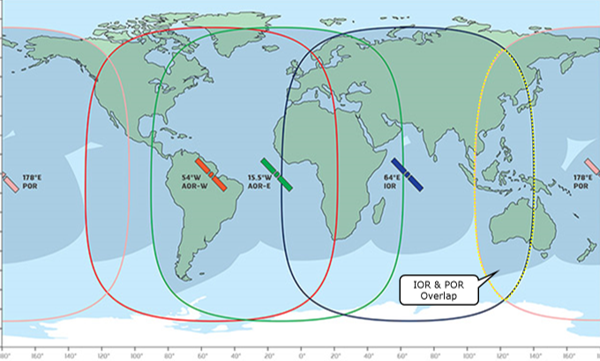
Global coverage of Inmarsat’s I3 network, showing the overlap region of the IOR and POR satellites
Last month, we published the complete logs for all communications that occurred on March 7 and 8, 2014, between the SATCOM unit aboard airframe 9M-MRO and the Inmarsat satellite network. (All times and days refer to UTC.) This includes communications before and during MH370 as well as the previous flight, MH371, between Beijing and Kuala Lumpur. Now that we’ve had a chance to investigate the logs for several weeks, I’ve summarized some of the findings. I’ve attempted to give proper credit to the individuals that worked on various aspects. If I have inadvertently omitted an individual, just let me know.
Observation: The log-on requests at 18:25:27 and 00:19:29 both had low carrier-to-noise-density (C/No) ratios, but normal receive power levels, indicating high noise levels. Similarly low (C/No) ratios were observed several times during MH371 under normal conditions. (Mike Exner)
Inference: The low (C/No) ratios at 18:25:27 and 00:19:29 were not likely due to abnormal aircraft maneuvers or attitudes.
Observation: When MH371 was traveling in a region of overlapping satellite coverage of the IOR and POR satellites, there were multiple automatic log-offs and log-ons with no indication of problems. (Many)
Inference: The multiple log-off and log-ons seen during MH371 are not indicative of a problem with the SATCOM.
Observation: An in-flight log-on does not produce abnormal values of BFO unless the log-on was part of power up sequence following an extended period during which the SATCOM was powered down. (Many)
Inference: This increases the likelihood that the SATCOM was unpowered for an extended period of time prior to the log-on at 18:25, and increases the likelihood that the abnormal BFOs during the log-on at 00:19 were due to an increasingly high rate of descent.
Observation: Abnormally high BTO values for a log-on request burst can be corrected with an offset of 4600 μs. (Many)
Inference: The corrected value of the BTO at 00:19:29 is 23000 – 4600 = 18400 μs, as previously suggested by Inmarsat. An adjustment to the position of the 7th arc does not seem to be warranted.
Observation: Abnormally high BTO values for a log-on acknowledge burst can be corrected with an offset of N*S, where N is an integer between 1 and 5, inclusive, and S=7812.5 μs. The value of S=7812.5 μs corresponds to the width of a slot, where a frame of 500 ms is comprised of 64 slots. (Don Thompson)
Inference: The corrected value of the BTO at 00:19:37 is 49660 – 4*7812.5 = 18410 μs, which statistically agrees with the corrected value of 18400 μs at 00:19:29. Again, an adjustment to the position of the 7th arc does not seem to be warranted.
Observation: Maintenance messages were generated after MH371 landed in Kuala Lumpur. However, no ACARS maintenance messages were generated during the flight. (@Andrew)
Inference: If a serious condition had arisen during MH371, it would have generated an ACARS message. Therefore, no serious condition arose during MH371.
Observation: When a 2nd log-on request message occurs one second after the first, it is related to initialization of the In-flight Entertainment System (IFE), and the message does not contain information about the Flight ID. If a 2nd log-on request does not occur, it suggests the IFE was not available at that time, possibly because the IFE has not yet completed its power up sequence. (Don Thompson)
Inference: This increases the likelihood that the IFE was unpowered prior to the log-on at 18:25 and unpowered prior to the log-on at 00:19.
Observation: During a log-on sequence, the SATCOM transmits a value for the “Prev Sat ID”. If the log-on occurs after a log-off request, or after a power interruption, the previous satellite value is cleared and a value of 63 (077) is transmitted. This value was transmitted for the log-on at 18:25 and the log-on at 00:19. There may be other causes for 63 to be transmitted that did not occur during MH371. (@el-gato, Don Thompson, and Richard Godfrey)
Inference: Since no log-off request was recorded prior to the log-ons at 18:25 and 00:19, it is likely that a power interruption preceded each of these log-ons.
Observation: Fuel flow data extracted from the ACARS reports for MH371 showed that the right engine burned fuel about 3.3% faster than the left during cruise. (Mike Exner, Don Thompson, Richard Godfrey)
Inference: If there was no fuel rebalancing by a pilot, the right tank for MH370 would have run dry about 15 minutes before the left tank.
Observation (preliminary): The measured values of BTO and BFO for MH371 agree with the BTO and BFO models that were used to reconstruct the flight path for MH370. (@sk999, Richard Godfrey)
Inference: The measured values of BTO and BFO for MH370 can be used to disqualify hypothetical paths with predicted values of BTO and BFO that do not match the measured values, as the ATSB and independent investigators have assumed.
In summary, the previous flight MH371 seems to have been normal in all respects. Using the satellite data from MH371, we have a higher level of confidence that for MH370, power was interrupted to the SATCOM prior to the log-ons at 18:25 and 00:19, and also higher level of confidence that the aircraft was in an increasingly steep descent at 00:19.
Considering that the newly available data generally supports the conclusions of the official investigators, it remains a mystery as to why Malaysia withheld the data for so long, and why it chose to release the data at this time.
I hope everybody is enjoying today, the Fourth of July, including Americans celebrating Independence Day.
Nice summary, Victor. Thanks. I would hope that the fuel model authors can finally put the calibration/verification of their models to bed so that we may have a high-fidelity fuel burn model allowing kg burned/minute or hour to be derived from altitude, speed, weight, temperature.
@Paul Smithson: Thank you. I also agree that a validated fuel model would be helpful.
@Paul Smithson
@Victor
Agree with you guys – a validated fuel model is top of the list of “must haves”.
here’s a summary of MH371 ACARS fuel observations: https://goo.gl/uMC1o6
The Right and Left fuel flow values observed on MH371 were similar to those on MH370 for take off and climb. But we have no cruise phase observations for MH370. Given the similarity of the take off and climb consumption rates, it is reasonable to assume that the cruise phase rates would be the same for MH370, adjusted for the assumed MH370 altitude, Mach, OAT, etc.
@Victor
Nice summary. Thanks for that.
I will take issue with a part of the following observation/inference:
Observation: An in-flight log-on does not produce abnormal values of BFO unless the log-on was part of power up sequence following an extended period during which the SATCOM was powered down. (Many)
Inference: This increases the likelihood that the SATCOM was unpowered for an extended period of time prior to the log-on at 18:25, and increases the likelihood that the abnormal BFOs during the log-on at 00:19 were due to an increasingly high rate of descent.
The 18:25 logon is characterized by a low BFO value (actually a BFO value that perfectly matches the speed and track of the aircraft at that time) which precedes the subsequently abnormal BFO values. This behavior is unique. Not one other example (as you say there are many) of a power on BFO sequence exhibits this type of behavior. All other examples are characterized by abnormal BFO values that subsequently converge to the anticipated values – behavior you would expect from oscillator temperature settling.
While it is possible the SATCOM was unpowered prior to 18:25, I do not believe it is prudent to put the 18:25 logon in “explained” category.
I do agree with the high rate of descent inference at 00:19.
As I noted during most of 2016, the DSTG report 03 Dec 2015 reached the same conclusion that the SDU was unpowered from 18:03 to 18:25 UTC. Since the 17:37 UTC handshake was missed entirely, it is also reasonable to assume duration was from 17:22 to 18:25 UTC.
If the cabin was depressurised through most of this time then the 125Hz shift in BTO values could well be the result of rapid heating of the OXOCO from an ambient temperature of -44 degC. This would give a false inference of MH370 flying west when it may have been the signal changing frequency as the crystal heated.
It is feasible too that the (MEC) equipment cooling override valve was already open at 35,000ft trying to cool an overheating electrical fault when a power failure struck.
Given enough severity to electrical failures, ie the loss of an IDG and the inability to close a tie breaker to switch to another generator the ELMS would perhaps have cut power to the solenoid controlling the pneumatic actuator for the override valve, thus leaving that valve stuck open.
This would reconcile how MH370 then developed into a hypoxic flight.
The absence of a log-off request supports electrical failure and conflicts with the suggestion that a pilot deliberately switched off the communications.
@Victor, Excellent Post! Many thanks.
We do have one cruise phase fuel flow rate information from MH371 at 05:06:41 UTC, when the aircraft was flying at 40,001 feet at Mach 0.832 and the Static Air Temperature was -56.0 °C (please see the decoded SU Log Excel: Tab “Flight 1” at 05:06:41).
https://www.dropbox.com/s/6sajojhz3p9v8yp/ISUs%20and%20SSUs.xlsx?dl=0
Cruise fuel flow rate is 3.51% higher in the Right Engine during flight MH371 at 05:06:41.
The Take Off data shows the Right Engine as 2.13% higher for MH371, whereas it was 1.90% higher for MH370.
The Climb data shows the Right Engine as 0.94% higher for MH371, whereas it was 1.30% higher for MH370.
At 06:56:34, MH371 was at 40,000 feet, GS of 478.8 knots with 10,846 kg fuel remaining and using fuel at a rate of 5,661 kg/hr.
MH370 had 1,919 kg more fuel than MH371 at Take Off.
If MH371 had carried on at 40,000 feet until fuel exhaustion at a rate of 5,661 kg/hr and also had 1,919 kg fuel on board like MH370, then the endurance would have been 7 hours 37 minutes 33 seconds.
The rate of 5,661 kg/hr would have improved a little as the Aircraft became lighter.
The endurance of MH370 was 7 hours 37 minutes 54 seconds, which is 21 seconds longer (34 kg of fuel).
The overall fuel usage profile on the MH370 flight was therefore not much different to the MH371 flight, despite the lower initial cruise and 3 step climbs of MH371 (27600 ft, 36000 ft, 38000 ft, 40000 ft).
It must be possible to put constraints on the overall range for MH370 and hence a limit for the earliest possible Final Major Turn (FMT) south (18:28:15) and a limit for the latest possible FMT south (19:41:03).
MH371 had flown 4442.51 km up until 06:56:34 and would have flown a further 1999.64 km until fuel exhaustion at 478.8 knots, giving a range of 6442.15 km.
MH370 had flown 1562.07 km up until 18:28:15 to a position around 7.2256°N 95.7516°E.
The earliest possible FMT at 18:28:15 from 7.2256°N 95.7516°E, would place MH370 on the 7th Arc at around 36.4°S.
If MH370 carried on a track of 295.9907°T to a loiter until 19:41:03 (covering a further distance of 1075 km in the time since 18:28:15), where MH370 was then heading south from 8.5261°N 93.0585°E, then this would place MH370 on the 7th Arc at around 24.5°S.
If we accept the ATSB Search was thorough, then the lower bound of any new search area is 33°S.
The primary new search area is still, in my view, along the 7th Arc from 27°S to 31°S, based on the floating debris analysis.
The secondary new search area is still, in my view, along the 7th Arc from 24.5°S to 33°S, based on the available fuel and negative ATSB search area result.
(Please see the tab “Range” in the linked Excel for the Fuel Calculations)
@Simon Gunson,
BTO is measured in microseconds not Hz. The sequence of BTO data recorded during the Log On and while establishing the Data-3 connection for IFE shows the AES range to the satellite diminishing, the aircraft track was towards the Nicobar Islands.
The purpose of the (small) MEC equipment cooling override valve is to vent any possible smoke found in the MEC ventilation ducting out of the aircraft rather than for it to follow the normal ventilation flow into the cargo hold (where a proportion flows out of the aircraft via the outflow valves). Outflow from the cabin, and flight compartment, environment is normally replenished by fresh air bled in from the engines.
There is no indication why the AES appears to have been unpowered prior to 18:25 whereas, after that time, its operation appears normal which also indicates that the ‘network’ of aircraft systems required to feed data to the AES were functioning normally.
@Richard: Thank you so much for posting your most recent thoughts. At this point, I agree with your recommendations for the primary search area. A descent at 18:40 and a late FMT doesn’t seem to be a very popular idea within the ATSB, but it does seem to fit the timing and location of the debris finds. Hopefully, there will be a way to determine whether the surface search was as efficient and thorough as CSIRO believed when they proposed the 35S impact site.
@Richard. Would you mind spelling out your assumptions?
“The earliest possible FMT at 18:28:15 from 7.2256°N 95.7516°E, would place MH370 on the 7th Arc at around 36.4°S.”
@ Don Thompson
Thanks a lot for the clarification & info! I was not aware that the Data-3 log-on request SU had a different format. Is there a more comprehensive documentation available somewhere in the public domain?
Regarding the repeated Log-on Request messages, there is more to the story than just the IFE.
Immediately after the 0x15 Log-on/Log-off Acknowledge messages that complete the log-on sequence are exchanged, the AES typically sends three R channel user data packets. When there are two Log-on Request messages, these packets contain the aircraft tail number (9M-MRO) and flight ID (MH0371 or MH0370) (I think sent as one and two packets respectively). The GES then sends four P channel user data packets in return. The tail number is repeated there. There is only a 4.5 second delay between the 0x15 and subsequent R channel messages.
At 12:50:19.735, when we presume that power had been restored to the aircraft, there was just one Log-on Request message. There were still three R channel user data packets sent. One had the correct tail number (9M-MRO), the other two had a bogus flight number (MH0000). The return P channel packets did include the proper tail number. Again there was a 4.5 second delay between the 0x15 and subsequent R channel messages.
At 18:25:27.421, the second example of one Log-on Request message, only two R channel user data packets were sent, and neither had decipherable information. The GES returned only two P channel user data packets, and again neither had useful information. This time, there was an 88 second delay between the 0x15 and subsequent R channel messages.
At 00:19:29.416, the third and final time only one Log-on Request message was sent, no R channel user data packets were sent.
Thus, the two in-flight log-ons after a power up were distinguishably different from the earlier one on the ground.
@Richard. To save you the trouble of unnecessarily detailed response.
I have downloaded and reviewed your spreadsheet and formulas. What I understand you to have done [please correct me if I misrepresent] is as follows:
1. Take range flown by MH371 (leg measurements presumed over ground, not through air)
2. Work out how much further it would have flown if fuel consumption continued at 5661kg/hr (representing burn rate of MH371 at FL400, M0.82, gross weight 186.317kg) until fuel exhaustion, adjusted for the initial fuel qty difference between MH371 and MH370
3. Take the resulting distance, measure off from presumed position at 18:28:15 to intersection with the 7th arc.
Even if we assume that the engines behave in identical fashion and that there were no differences in electrical load to affect fuel burn there are possible sources of false-equivalence/erroneous extrapolation inherent in your method:-
– headwind difference between the two flights
– fuel efficiency (kg per km) between take off and time at fuel remaining of 11,100kg assumed to be near-enough identical for the two flights (requires weights/speed & alt profile/TAT delta/headwinds to be nearly equivalent)
– fuel efficiency (kg per km) of MH370 from 11,100kg through to fuel exhaustion identical to MH371 at that point despite differences in ZFW, speed/altitude and diminishing GWT
While I appreciate you going to the trouble of performing these extrapolations, I do think they should come with due consideration of implicit assumptions – which means that they are a “thumb-suck” – ‘close enough for government work’, as some wags prefer to put it. Would you agree that they should not be portrayed as precision estimates of MH370 fuel endurance or efficiency?
@el_gato,
Is there a more comprehensive documentation available somewhere in the public domain?
I do have a copy of ARINC-741 Part 2, however it doesn’t present much more information than ref [2] as you cite. I have some long distant experience of X.25/ISO-8208 comms that has helped me fill in some gaps.
@sk999
Regarding the repeated Log-on Request messages
It appears consistent that a single LOR burst, with sequence identifier 1, defines the GES Log On Request after a power on has occurred. When a GES handover or Log On renewal occurs, the Log On is defined by two LOR bursts with seq id > 1.
If the ACARS function is operating the GES Log On is followed by an ACARS Link Test message – contained in the 3 R-channel bursts (it’s short enough not to warrant a T-ch burst) – then an ACARS Media Advisory message.
All Log Ons prior to 18:25 evidence the Link Test (Type Q0) and Media Advisory (type SA).
The IFE system uses the AES-GES link as an ISO-8208 Satellite Sub-Network (SSN, aka Data-3), it employs a quite different format to the Data-2/ACARS information. Two initial messages (Connection Request SNPDUs) follow GES Log On: the SDU sends to its remote a brief control message, then sends the curious ‘Pet shop boys’ missive. When the GES Log On is initiated by a single LOR burst a longer interval is evident before the first of these SNPDUs are initiated (assumed IFE system takes longer to initialise than SDU).
The ACARS messages have priority over the IFE comms, so Link Test and Media Advisory are typically exchanged before the IFE Comms.
At 18:25, only the two ISO-8208 SSN messages are logged after the GES Log On.
At 00:19, only the GES Log On completes.
@Brock
The timing of the latter MAS 8-March statement, if I am not mistaken, may be consistent with the 2nd satellite telcon. I believe the MAS senior management (CEO?) came to the airport early (5AM) for a planed flight, and got involved in managing the response. What I recall about his reaction was he said they assumed the aircraft was still in the air (presumably based on the sat calls going through to the aircraft- but unanswered).
@Mick
Right now I assume the MH370 BTO/BFO data is accurate, including the sat calls. Therefore at least as a base case, I feel we need a proposed flight path the meets all the numbers. Seems to me what we have now is folks proposing paths, and when the path fails to meet BFO, we just say, well that’s because BFO is allowed to be “off”. At the moment I think a descent is needed to have a flight path that meets 22:41 and 23:14 sat call BFO. I see a slow descent starting around twilight at around 22:50 so I am not expecting level flight after Arc5. Also I think maneuvers are happening around 19:41. So that leaves Arc3 to Arc5 as the possible straight level flight period. I do not agree with the idea that a straight flight has a straight BFO curve, especially when the aircraft is passing thru the close approach to the satellite at about 19:50, a straight flight path should have a curved BFO plot, I am thinking.
@Tbill
“Seems to me what we have now is folks proposing paths, and when the path fails to meet BFO, we just say, well that’s because BFO is allowed to be “off”.”
You might want to take a look at Figure 5.4 of “Bayesian Methods…” before implying that people’s attitudes have somehow changed for the worse. The BFO is simply not as reliable as was generally believed in our work done earlier.
@DennisW
I reserve the right to learn more and change my view, but that’s where I am at today. If we truly embrace the piloted flight option, then BFO potentially becomes a story of what the pilot did.
@Simon Gunson
“It is feasible too that the (MEC) equipment cooling override valve was already open at 35,000ft trying to cool an overheating electrical fault when a power failure struck.
Given enough severity to electrical failures, ie the loss of an IDG and the inability to close a tie breaker to switch to another generator the ELMS would perhaps have cut power to the solenoid controlling the pneumatic actuator for the override valve, thus leaving that valve stuck open.
This would reconcile how MH370 then developed into a hypoxic flight.”
A couple of points:
1. The override valve is actuated by two electric motors, both powered by 28V DC from the Capt’s flight instrument bus. The controller is powered by the same bus. The Capt flight instrument bus powers essential equipment and has multiple power sources to cater for electrical failures. In the extreme, it will be powered by the aircraft battery. ELMS does not load shed the Capt flight instrument bus or the override valve.
2. As Don Thompson pointed out, the override valve simply redirects air to vent the MEC and ventilation ducting of smoke via the forward outflow valve. That air would normally exit the aircraft via the outflow valve anyway, via a different pathway. Opening the valve makes no difference to the aircraft’s pressurisation.
@Victor
Thank you for compiling that excellent summary.
@Don Thompson
Regarding “Inference: This increases the likelihood that the IFE was unpowered prior to the log-on at 18:25 and unpowered prior to the log-on at 00:19.”
The IFE set up a Data-3 connection at 1827:03 about 90 seconds after the SATCOM log-on had successfully completed at 1825:34. Is there an inference that the IFE connection should have happened more quickly than that if the IFE was already powered when the SATCOM logged on?
@ROB
Re: “… there can be no reasonable doubt that the Captain’s intention was to hide the plane in a remote area of the SIO.”
Where is the evidence as to the Captain’s intentions? The flight sim data? That shows a steep descent on fuel exhaustion, not a controlled glide.
Re: “… and scatter debris far and wide for the searchers to spot… ”
What searchers? This allegedly “carefully pre-planned hijacking by the Captain” placed the impact point 2,500 nautical miles from where the airplane had last been seen. Who was going to be searching for it in the Southern Indian Ocean?
Re: “ The best way to achieve this goal is in my humble opinion, to control the impact conditions … ”
And the best way to control the impact conditions is to retain engine power by avoiding fuel exhaustion. The Boeing B777 FCTM makes this point very clearly under Ditching (pp. 8.4-8.5);
“… do not reduce fuel to a critical amount, as ditching with engine thrust available improves ability to properly control touchdown.”
So why would someone intent on bringing the airplane down “as intact as possible” risk a ditching under the completely unnecessary handicap of being unable to adjust and manage his descent rate, touch down point and touch down speed?
@Mick
“So why would someone intent on bringing the airplane down “as intact as possible” risk a ditching under the completely unnecessary handicap of being unable to adjust and manage his descent rate, touch down point and touch down speed?”
Excellent point.
@Mick Gilbert said: Where is the evidence as to the Captain’s intentions? The flight sim data? That shows a steep descent on fuel exhaustion, not a controlled glide.
That’s not true. When we studied the simulator data, I installed the PSS777 on FS9, and Yves and I tried to replicate the flight. To replicate the end-of-flight after fuel exhaustion, I started with the data set from 45S1 and created and recorded a simulation that ended with the conditions found in the 45S2 data set (before the change in altitude by the user). This required pilot input to level the wings and maintain altitude. Next I created and recorded a second simulation starting with the 45S2 data set (after the change in altitude to 4000 ft) and ending with impact in the ocean, with no pilot input. For neither of these two simulations was a high speed descent encountered.
That said, we are more sure than ever that the BFO data indicate that MH370 was in a steep descent at 00:19.
@All
I have a question and would really appreciate everyone with an opinion to chime in. Ignoring everything else we believe we understand and/or think about MH370, is the debris discovered to date more indicative of a low energy or high energy event? Again, I am only interested in what people believe the condition of the debris is more suggestive of.
Also, for the sake of this exercise lets assume that there was no mid-air break up and no flutter. Only an intact airplane crashing into the water.
I understand that opinions vary on the matter and that the debris does not allow for a definitive, high confidence determination. But just analyzing the debris and it’s condition, which way do you lean?
Thanks, and keep up the excellent work. And thank you Victor for the considerable time you have invested, and for being a fair and reasonable moderator. Happy 4th everyone.
@Richard
Thank you for the comments on flight distance. In your flight distance calcs, I would ask what are the assumptions? What if the pilot started descending at 300 ft/sec at Arc5, could he go farther? In other words, are you assuming “straight” level flight until FE?
@Richard
Correction above should say 300 ft/min descent rate (I cannot get used to ft/min units)
@TBill: thanks. For crystal clarity: I am roughly a trillion times more interested in the rationale for the time GIVEN in the media statement (18:40 UTC: time of lost contact) than I am with the rationale for the time OF the statement. Any thoughts as to why MAS – with the benefit of its CEO helping manage communications, as you say – originally claimed it had maintained contact with MH370 until roughly 18:40 UTC?
(I think questions like this need to be revisited by keen and open minds, given the unsubstantiated nature – and greasy feel – of all “evidence” that has ever been used to support the narrative that MH370 diverted west, let alone south.)
Interesting – ABC Australia
http://www.abc.net.au/news/2017-07-05/the-search-for-mh370-narrows/8680662
Full ABC Article is here:
http://www.abc.net.au/news/2017-07-05/mh370-search-further-narrowed-to-fraction-of-seventh-arc/8678532
@Victor
Thank you for sharing those simulations (I can’t seem to get the first one to load); I accept your point that inferring a steep descent by simply joining 45S1 and 45S2 is incorrect.
However, your simulations are not evidence of what the Captain did nor are they evidence of the Captain’s intentions; they are evidence of what you did. What happened on the Captain’s flight simulator immediately before or after the two point in time data captures at 45S1 and 45S2 is speculative. There is no evidence that the simulation on the Captain’s flight sim persisted beyond 45S2.
@Donald
Here’s my “4 pennysworth” on the debris. Well, you did ask! Note, these are my opinions only – others may/will disagree.
It’s not easy to give a quick answer. The only thing certain is it wasn’t a soft, controlled ditching. On the other hand, it doesn’t appear to be an uncontrolled, high speed impact, either. It’s very unlikely at this stage, that any more significant new debris will turn up – I cannot see how there can be anything major still circulating around in the ocean gyre or waiting to be discovered on a beach. Basically, everything that got separated and was able to remain afloat, has made it to land. This is in itself rather remarkable, when you think of it. The majority of identifiable major pieces have come from the RH wing trailing edge, in the region aft of the RH engine mounting. Importantly, if there had been a general breakup of the airframe, there would have been a wider assortment of debris.
Separation of item nos 9 and 15, the RH and LH flaperon fixed panels, respectively, from mirrored locations on the wing upper surface, suggest detachment due to air loads (overspeed) rather than due to impact with the water. The two skin panels from the empennage (RH side) also suggest, to me, excessive air loads as an originating mechanism.
The flaperon is particularly problematic. Basically, the condition of the hinge mountings (nearly identical clean breaks) suggest either suddenly applied force from below with both actuators powered at the time, or flutter. The trailing edge damage could result from either of these conditions. However, the general informed consensus in aviation circles generally seems to be that flutter is unlikely.
The impact was severe enough to breach the hull, and release a severely damaged cubicle partition panel, location near door 1R, and the IFE seat back bezel from economy class.
On the other hand, no section of either inboard flap has been recovered. These are major trailing edge components. It is difficult to see how no pieces of inboard flap made it to land unless they remained on the aircraft at impact.
Personally, I think the debris suggests a deliberately controlled, high speed impact of relatively low forward velocity but high vertical velocity, after a recovery from a grossly overspeeded dive. But I am quite prepared to admit that I could have got it totally wrong, and what we are actually seeing is the result of an uncontrolled impact with a low angle of incidence. However, the condition of items 9 and 15, and of the RH flaperon are somewhat problematic for the uncontrolled impact scenario
Much more forensic work needs to be done on the recovered pieces, preferably by an independent investigator.
@Mick
[…] at 1825:34. Is there an inference that the IFE connection should have happened more quickly than that if the IFE was already powered when the SATCOM logged on?
Yes: at 12:50 the log shows the delay from GES Log On to initial Connection Rqst to be 2m35s and, at 18:25, 1m28s. Each of these events is followed, after another 62s, by a second Connection Rqst containing ‘Psb’).
After a normal GES handover or renewal Log On, the delay is in the order of 66s with both Connection Rqsts occurring virtually simultaneously.
While the term ‘IFE’ has been generally used, the key components with interfaces to the SDU are the EPESC (data via DCMF) and the CTU (pax voice).
@All, do we know for fact that the intent of the PIC was to leave a minimum of debris trail? Perhaps he simply got lucky in that respect or could have cared less. Valuable time was lost looking in the wrong place. ZS would have been confident that the SIO would be shere hell to search and it’s doubtful BFO even crossed his mind and would be used to try and pinpoint the terminus. His thinking would have been more simple i.e. MY would not spend the money to search long, that MY would not know where to search and that the world would quickly move on having lost interest. The reality of the commitment to find M9MRO as we know it to be would have escaped him fully, my opinion of course.
@Mick Gilbert said: However, your simulations are not evidence of what the Captain did nor are they evidence of the Captain’s intentions; they are evidence of what you did. What happened on the Captain’s flight simulator immediately before or after the two point in time data captures at 45S1 and 45S2 is speculative. There is no evidence that the simulation on the Captain’s flight sim persisted beyond 45S2.
The purpose of my comment was to correct YOUR claim that there was a steep descent in the simulation. There is no evidence of that. How he ended the simulation is anybody’s guess.
@ventus45: I see nothing new in the recent flurry of news that wasn’t already discussed before, as you can see by reading this post and the associated comments. The post includes an exchange with David Griffin of CSIRO. A hypothetical impact site at 35S has these problems:
1. The seabed was already scanned close to the 7th arc at this latitude.
2. CSIRO’s own drift results predict that some debris would reach Western Australia, even though the initial drift is to the northwest of the impact site. This can be seen in Google Earth using this KMZ file, provided by CSIRO.
3. An impact at this latitude cannot explain the timing of the discovery of “Roy” in South Africa in December 2015.
So, although I agree that an impact along the 7th arc at 35S is possible, I think it is far from the “slam-dunk” that CSIRO is claiming it is.
My guess is that this is a part of a concerted effort to drum up support to restart the search, which I think is a positive development. However, we have to be technically honest and transparent about the true probabilities of finding the plane at this latitude.
@Victor
Your above post to Ventus, is a good sum-up up of the situation on ATSB’s proposed 25,000 km search zone.
But the question is – would the ATSB be cynical enough to push for a search in this area despite knowing that the evidence for it is decidedly shaky? Are they just looking for a way to cover themselves in the eyes of their peers, just to be able to sit back and say they covers all bases? Unfortunately, this is what I suspect they are doing. Remember, they broke off searching this area, under mounting pressure both within and without the SSWG, from voices telling them that the area north of S36 was very unlikely, and that they should be concentrating on the statistical hotspot area further south. It was at the time that Phoenix was sent packing.
@Rob: The truth is, any hypothetical impact site has issues that have to be acknowledged. Although 30S seems more logical to many here because, as Richard Godfrey says, it better explains the lack of debris recovered from WA, the timing of “Roy” in South Africa, and the temperature history of the barnacles, it also has the following issues:
1. It predicts earlier arrival of debris to Eastern Africa than the actual timing of the finds. (This could be attributed to a time lag between arrival and discovery of debris.)
2. It was searched by air after the disappearance. (This could be explained by the timing and the limitations of the aerial search.)
3. The northern latitude of the impact site suggests a later FMT than 18:40. (This can be explained by the descent at 18:40 followed by a loiter/manoeuver before turning south.)
So, in many ways, the selection of the next priority area comes down to ranking the credibility of the available evidence and analyses.
@Irthe turner
Speaking for those of us who feel this accident may have been intentional:
No, we do not know if the PIC tried somehow to minimize debris, and if so, what technique(s) he may have employed. Most would agree with your statement that the PIC probably did not know the BTO/BFO data was being transmitted. That data tends to suggest PIC was hiding the crash in the SIO assuming nobody knew he would have turned that direction.
Many agree with an apparent overall strategy to hide the aircraft, but other than flying south, exactly how is unknown. One alternate theory is that the pilot was targeting a specific deep zone around Broken Ridge, so that could possibly explain a dive to hit a specific area.
@Brock
Here is the MAS interview account. It is with Hugh Dunleavy then the Director of Commercial Operations for MAS, who happened to be at KLIA for an early flight on 8-March.
http://www.standard.co.uk/lifestyle/london-life/the-plane-truth-malaysia-airlines-boss-hugh-dunleavy-on-what-really-happened-the-night-flight-mh370-9556444.html
@Simon Gunson
Why do think a depressure scenario results in -44 deg C of the equipment? I realize thermodynamics of depressuring results in an instantaneous temperature drop of the air in the aircraft, depending on the rate of depressuring. But the immediate next step in that process is that the air starts warming back up due to heat exchange with the surroundings, which is still at room temperature. Furthermore, the warm bleed air would presumably be coming in the cabin. I do not believe that we have very good information about final temperature after a depressurization, though I wonder if Boeing has models for predicting the complex factors going into that assessment.
@Ventus45
@All
Sorry but I just have to say something on the recent ABC report, because its a prime example of the obscure, woolly logic being used by the Australian to justify their search strategy, a strategy that is bound to make a successful outcome less likely. Dr Griffin is reported as saying at a recent marine conference in Darwin, that quote: “specific damage to an outer flap of the plane that washed up in Tanzania, showed it was not deployed, which in turn suggested the pilot was not in control and had a hard landing”. Unquote.
The inference from Dr Griffin’s above comment is that the pilot might theoretically have been considering making a soft landing! But what in heaven’s name could the pilot have had any reason for attempting a soft landing. I mean, consider the scenario: the pilot goes out of his way to conceal his intended destination, an extremely remote area of the SIO, flies there until fuel exhaustion with a cargo of unwilling of not already dead passengers, and then considers the option of extending flaps for a soft landing, sorry ditching1
It shows that the people responsible for making vital decisions on the search strategy cannot be taken seriously, which is very worrying. Basically, the ATSB examined the outboard flap and decided the evidence showed that it and probably the flaperon also, were in the retracted position at impact, and that this supported their theory of no active control after fuel exhaustion, a theory originally supported for one reason and one reason only – to conveniently place practical limits on the search area.
So what if the pilot actually intended to hide the plane as effectively and rapidly as possible and minimize surface debris, and without for one moment considering taking to a life raft? If you want an answer to this one, obviously don’t ask the ATSB and their associates.
Edit to last post, second line down: for Australian, read Australians.
One letter missed in error completely changes the narrative. By Australians, I mean DSTG, ATSB, CSIRO.
@Victor
Comparing your two “lists” below:
35S//////
A hypothetical impact site at 35S has these problems:
1. The seabed was already scanned close to the 7th arc at this latitude.
2. CSIRO’s own drift results predict that some debris would reach Western Australia, even though the initial drift is to the northwest of the impact site. This can be seen in Google Earth using this KMZ file, provided by CSIRO.
3. An impact at this latitude cannot explain the timing of the discovery of “Roy” in South Africa in December 2015.
//////
30S/////
it also has the following issues:
1. It predicts earlier arrival of debris to Eastern Africa than the actual timing of the finds. (This could be attributed to a time lag between arrival and discovery of debris.)
2. It was searched by air after the disappearance. (This could be explained by the timing and the limitations of the aerial search.)
3. The northern latitude of the impact site suggests a later FMT than 18:40. (This can be explained by the descent at 18:40 followed by a loiter/manoeuver before turning south.)
//////
The two lists of “problems” are not even close, IMO. The 30S terminus is clearly the preferred conclusion. There is no ready explanation for any items on the CSIRO list.
@DennisW: I tend to agree that 30S is the better option, but the list questioning 30S is what the ATSB and CSIRO are clinging to.
If CSIRO and/or ATSB (Australia) could come up with even only one confirmed or highly likely piece from the WA coast they would have a much stronger case with 35S.
But without it (as it stands) they miss the most important cornerstone to make their 35S assumptions ‘evidence- based’ enough to conduct a new search in that area. IMO it would be a waste of time, money and effort.
It’s clear to many who studied their KMZ-files and the combined debris-drift studies the area north around 30S (IMO starting from ~32.5S) fits the facts a lot better.
If they only could come up with one piece of WA debris..
Information from ACARS OOOI messages:
Departure from gate is about 1:01.
Takeoff is about 1:34.
Touchdown is about 7:28.
Arrival at gate is about 7:37.
BFOs from LGA communications have big offsets relative to HGA comms. BTOs look OK. The switch from HGA to LGA came just after touchdown. The same behavior was seen on the prior flight from KL up to Beijing.
For an impact location around S30 I estimate you need an average BFO error of around 5 Hz for the interval 19:41 – 00:19. Based on SK999’s recent results for MH371 this is not impossible but perhaps a bit on the high side. Following DSTG results it is less of a problem, however I’m not sure about the solidity of their BFO error analysis. For example the fact that they speak about “geographic dependency” and a “structured bias” doesn’t sit well with me. So I feel there is still a strong need to have access to the data and calculations behind the histogram (fig. 5.5, based on 20 flights prior to MH370)
In my calculations, minimizing the average BFO error results in an end location closer to S35. (All of this under the assumption of constant TT paths)
@Neils
sk999 never (to my knowledge) did a best fit straight line to his data. Only vague claims relative to the error drift (if any). My own conclusion eyeballing his data is different.
The DSTG BFO error analysis was flawed by the fact that they applied a statistical process suitable for a stationary and ergodic process to a physical process which is neither stationary nor ergodic. I called them on it. In this case I got the response below:
////
We are aware that the oscillator behaviour is strictly speaking, not stationary and ergodic. Fig. 5.4 from the DST Group book indeed indicates this. The first paragraph below that figure states “The mean bias is different between flights and even within a single flight there is evidence of structured variation.”
////
What all this means (short version) is that the BFO error measured on any particular flight cannot be interpreted as representative of what it might be on any previous or subsequent flight. Minimizing BFO error as part of a flight path qualifier is meaningless.
sk999:
I don’t see any significant change in BFO values circa 07:29. I see some R600 transmissions, but the BFO remained 178-182 during that period. Please clarify. Where in the log does it indicate an antenna change?
ALSM,
First table of the spreadsheet, AES Process, gives the times and parameters for each log-on session. The AES switches between HGA and LGA several times. A good boundary is between 7:38 (LGA) and 7:58 (HGA). Another boundary is between 7:58 (HGA) and 8:01 (LGA). These are for the IOR satellite. The discontinuity is over 150 hz for the POR satellite (e.g., between 15:56 and 15:57).
@ROB
Re: “The inference from Dr Griffin’s above comment is that the pilot might theoretically have been considering making a soft landing! But what in heaven’s name could the pilot have had any reason for attempting a soft landing. I mean, consider the scenario: the pilot goes out of his way to conceal his intended destination, an extremely remote area of the SIO, flies there until fuel exhaustion with a cargo of unwilling of not already dead passengers, and then considers the option of extending flaps for a soft landing, sorry ditching”
You’ve previously opined that a malicious perpetrator would seek “to control the impact conditions” for the airplane so as to “make sure it sank as intact as possible“. Isn’t that a “soft landing” and essentially the same postulate that you’re now criticising Dr Griffin for adopting?
@Don Thompson
G’day Don. Thank you for the clarification regarding the “IFE” log on times. Three questions come to mind;
Could the software downgrade on the EPESC that was carried out before the flight (S/N 4918752 – 07 March 2014) have had any impact on the log-on process?
Off which buses are the CPMU (does EPESC run on the CPMU?) and CTU powered?
Do you know what the power-up/boot-up times are for the CPMU and the CTU or how they compare to the SDU?
sk999:
There were small BFO changes at 07:36 and 07:58 (~10-20 Hz). At 15:56, there was a large jump (~155 Hz). But the 15:56 change was associated with the IRU alignment, thus not unexplained or odd.
A change from LGA to HGA should not cause any change in BFO. The shift at 15:56 is understood, but I agree that the small changes at 07:36 and 07:58 are interesting. Might be worth looking more closely at those two.
DennisW,
You have flogged your viewpoints regarding the BFO numerous times. We hear. You need not continue. What you have not mentioned is that the DSTG, while improperly treating the BFO error as a Gaussian random variable, assigned it a 1-sigma error of 7 hz. That is most curious, given that the Inmarsat JON paper said that 7 hz should be the outer envelope, not 1-sigma. In essence, the DSTG ignored the BFO other than to use it to distinguish between North and South routes. The net result is apparent in Figure 10.7, lower panel, of the DSTG “book”. This panel shows the residuals between all the models they ran and the actual data. There a nine points. Only one point is above 1-sigma. Very curious. Is that odd, or expected? If the BFO errors were truly random Gaussians, then it would be extremely odd. However, if there were large correlations amongst the errors, and in particular, correlations of the type that you have been hammering on, then perhaps no, the residuals are not unexpected. But it depends on the nature of those correlations.
Bottom line – the question is not whether the DSTG included information that it should not have – rather, it is whether the BFOs are not as bad as the DSTG has portrayed them, and is there something to be gleaned from them.
Geoff Thomas in the West Australian picked up the post:
https://thewest.com.au/news/wa/mh370-plane-in-spiral-dive-before-crash-ng-b88527447z
ALSM
10-20 hz is huge, not small. It stood out like a sore thumb.
IRS realignment is sensible, but is it expected that it coincides PRECISELY with a change from LGA to HGA?
Much work ahead. Had anyone else tried to model the BFO/BTOs? Or done a proper fuel model? I have a very preliminary one – not ready to post yet.
@ALSM
“You have flogged your viewpoints regarding the BFO numerous times. We hear. You need not continue.”
Apparently “we” does not include Neils or TBill. In any case my post was not directed at you.
“Bottom line – the question is not whether the DSTG included information that it should not have – rather, it is whether the BFOs are not as bad as the DSTG has portrayed them, and is there something to be gleaned from them.”
Glean away. The DTSG portayal is what it is, and yes it is inappropriate for the process it portrays. We (you and I) have argued what the Inmarsat 7Hz number represented more than three years ago. I do not recall that we ever came to a conclusion.
If you can extract something meaningful from the data logged from a non-stationary and non-ergodic process there maybe a Nobel Prize in your future.
@sk999,
I am studying the MH371 fuel consumption data and comparing it with my fuel model, the MH370 Flight Brief, and another 9M-MRO flight for which I have FOQA data every second. In general, they are all quite close to one another, certainly within a couple per cent, and possibly even closer. One issue I hope to resolve is whether the same Cost Index was used in all cases. To do that requires getting a match to better than ~1%. This requires making corrections for the weight, altitude, and temperature for each leg to better than 1%. AS you well know, this is not a trivial exercise, and it is better to get the right answer than a quick answer.
@DennisW
Cease fire! Check your target.
(ALSM or sk999?)
@Victor
Re: “Geoff Thomas in the West Australian picked up the post:”
I was confused when Geoff said IG released an analysis, also spiral dive with nobody at the controls. I am thinking the data points to a dive based on BFO.
sk999:
Like I stated, “…07:36 and 07:58 are interesting….”. I am looking into those events. But they can’t be the direct result of an antenna change. That change by itself would have no effect on the frequency. But that does not rule out some other change that happens at the time of antenna changes. I’m guessing it has something to do with the SDU Doppler compensation algorithm.
DennisW: Wrong attribution?
@Mick
I have zero issues with sk999, and I am not “shooting” at anyone. Simply pointing out the limitations in how the data we have can realistically be used.
@Victor
@ROB
@Ventus45
Regarding Issue 2. It was searched by air after the disappearance. against 30S it is worth noting that there is roughly a 3600 km² “hole” in the surface search coverage that straddles the 7th arc at about 30°10’S 98°E.
Mick: I’d say the “…zero issues…” statement says a lot about bias.
@DennisW
Re: “I have zero issues with sk999, and I am not “shooting” at anyone. Simply pointing out the limitations in how the data we have can realistically be used.”
Okey doke, as you were then. Your previous comment was directed @ALSM but included quotes from sk999’s “You have flogged your viewpoints regarding the BFO numerous times. We hear. You need not continue.” post.
@Mick
Responding to your earlier post:
CPMU: do you mean CSMU (Cabin Systems Mgmt Unit)? If so, the EPESC is a separate system & LRU to the CSMU, however, they do have a direct interface to one another. The EPESC provides the packet data service for IFE via the SDU (routed via DCMF/AIMS).
Power: EPESC is powered from the Main AC L Bus and CTU via Main AC R.
Boot time: ATSB described boot times for IFE (at 18:25). I’d be surprised if the software load impacted the boot time.
The activity evident on the datalink establishes ISO-8208 switched virtual circuits to a remote ATN node, those SVCs are not related to voice and the CTU. Voice service is available to the CTU, and 2 channels to the flight compartment, as the GES Log On completes.
@Don Thompson
G’day Don, thank you for that reply, I got the gist of it, I’d be lying if I said that I understood all of it (your answer and I parted company at or abouts “ISO-8208 switched …).
My understanding of the IFE componentry is limited; I’m relying in part on the Factual Information Report, p. 49;
“CPMU is Cabin Passenger Management Unit, which provides an interface between the Panasonic IFE and the SDU, for any Data-3 SMS/e-mail messages.”
I had assumed that the CPMU was to data what the CTU was to voice.
Mick,
The references to which I have access describe a Matsushita/Panasonic 3000i IFE system fit in the B777.
There maybe a case of acronym disconnect between material authored by Matsushita/Panasonic for the 3000i IFE system (CPMU) and the Boeing AMM material (CSMU).
However, the EPESC is the component of the 3000i IFE system that provides the packet data interface from IFE through DCMF to the SDU. The CTU is concerned with voice/circuit switched service with the SDU.
@Mick
“Okey doke, as you were then. Your previous comment was directed @ALSM but included quotes from sk999’s “You have flogged your viewpoints regarding the BFO numerous times. We hear. You need not continue.” post.”
Ouch! Yes, I mistitled my response. My comment was intended for sk999, not for ALSM.
@TBill: Many journalists equate “pilot at the controls” with “long, controlled glide” and “no pilot at the controls” with “steep descent”. In fact, a pilot at the controls could have caused the steep descent.
@TBill: thanks for the link. In that interview, not only is the question “why did MAS first say, ‘lost contact at 18:40’?” never answered, it is never even asked. (I’m not sure which of those two derelictions of duty to the public is more terrifying…)
Can you link me any account of that key question being asked and answered?
Or even asked?
@TBill: From your article:
At its peak, the ballroom hosted 1,500 people. Dunleavy says much of the relatives’ anger was directed at the Malaysian government. “They blamed them for not tracking the aircraft more solidly.” The first week was spent searching in the south Indian Ocean — before an official source revealed the plane had been spotted on military radar making a U-turn and heading towards an island in the Malacca Strait.
“I only heard about this through the news,” Dunleavy says, for the first time letting anger inflect his voice — a hybrid English-German-Canadian accent thanks to a string of airline career moves. “I’m thinking, really? You couldn’t have told us that directly? Malaysia’s air traffic control and military radar are in the same freakin’ building. The military saw an aircraft turn and did nothing.
“They didn’t know it was MH370, their radar just identifies flying objects, yet a plane had gone down and the information about something in the sky turning around didn’t get released by the authorities until after a week. Why? I don’t know. I really wish I did.
So the head of MAS Operations claims to be as dumbfounded as the rest of us about Malaysia’s actions after the disappearance.
@Victor: thanks for posting the satellite coverage map.
@all: hypothetically, if you were trying to produce a fake (radar+signal) data log whose objectives were:
1) minimize all appearance of an intended destination, and
2) make the actual impact location as hard to pinpoint as possible
…can anyone come up with a more cleverly crafted set than those depicted in the grainy screenshots which appeared on the scene in Week 2 of this (now 174-week) search?
According to these dodgy images – for which direct accountability seems to have been carefully avoided – the plane heads immediately out of POR coverage (had it remained in the overlap, a precise path could have been triangulated), and then forthwith to the middle of nowhere.
@Brock – exactly ! Data provided is engineered to make it appear to have gone to the middle of nowhere…
Brock:
Re: “…had it remained in the overlap, a precise path could have been triangulated…”
That notion is not true. It takes more than 2 satellites in view to “triangulate” a position. You need two satellites in view AND two demodulators, one tracking the same AES via each satellite. The Inmarsat ground network never assigns two satellites/demodulators to the same AES. So there never was any way to triangulate a position using the Inmarsat system.
All:
Re Brock’s notion: “…had it remained in the overlap, a precise path could have been triangulated…”
For the reason noted above, a “precise path” could not have been triangulated. However, it is worth noting that an approximate path could be derived from the MH371 data since the AES switched satellites so many times. Kind of like a time multiplexed 2 satellite solution. So the MH371 data set does provide the information needed to calculate a series of range measurements from each satellite at different times. Even though those ranges were not simultaneous, they would provide a series of arcs from each satellite from which an approximate path could be estimated.
Interesting. So it seems to me the Inmarsat coverage map shows MH370 did not cross the ~105E longitude into the POR-region during its flight to the south if it did not switch to that POR satelite.
If this is correct at least the huge area east of ~105E could be excluded to have been entered by MH370?
If there is not some technical issues with which satellite(IOR vs POR) is taken as recording MH370 pings/etc maybe stronger focus on the data is actually relative to the POR satellite movement. What location along the western most 7th arc of the POR could be the flight terminus ?
@Paul Smithson
I agree with you that there are all kinds of assumptions in my calculations.
That is why I was only trying to set boundary conditions such as the primary new search area is along the 7th Arc from 27°S to 31°S and the secondary new search area is still along the 7th Arc from 24.5°S to 33°S. I think you will agree that these are fairly broad ranges.
If you want something more precise, then David Griffin of CSIRO is your man. He believes we can nail the MH370 End Point down to a small area around 35°S:
http://www.abc.net.au/news/2017-07-05/mh370-search-further-narrowed…/8678532
@Brock,
cleverly crafted
Alternatively, readily explained by…?
@Richard. I would take issue even with using those calcs as bookends/boundary conditions. I’m aware of the reasoning that CSIRO/”first principles review” has put forward for a more northerly terminus. The logic is persuasive but far from 100% compelling. My own money is on “38S” path being correct, but terminus lies beyond the search area.
@Victor
I always thought that interview with MAS’s Dunleavy was interesting.
> Re: military radar capturing the turn-back at IGARI, of course that was not real time, but my understanding is that the military were showing (Hish?) the radar recordings by the morning. In any event it sounds like MAS was not told.
> Dunleavy/MAS correctly realizes the aircraft may still be in flight even as it nears time to announce the loss of the flight. He does not say if the unanswered sat calls lead them t0 believe this.
> PAX families assumed a hijacking in progress with secret Malaysia negotiations. But Dunleavy says he knew that was not true as there was no communication with MH370. This contradicts the ongoing theory of secret communications.
> Dunleavy says may be decades to find MH370 (your blog may outlive us?)
> As you infer, one wonders if Dunleavy knew more than he said
> False reports out of China starting by 5AM MY time 8-March.
> How about this nugget:
“The airline (MAS) will this year (2014) install pioneering technology (from Inmarsat, the Old Street firm which gained global fame for its satellites’ role in the search for MH370) that means if a plane ever deviates from its flight path, it will send out a signal.”
Is that true? That would seem to be important advance.
@Tbill,
From the “Evening Standard” report, an example of the reporting which leads me to challenge the authenticity of what else is reported:-
” The first week was spent searching in the south Indian Ocean — before an official source revealed the plane had been spotted on military radar making a U-turn and heading towards an island in the Malacca Strait.”
Probably was referring to the south China Sea, but who knows?
Incremental update to my draft document on BTO/BFO modeling of MH371. After prodding from ALSM, I calculated the EAFC correction for the POR satellite BFO data (which consists entirely of subtracting the bogus EAFC “correction” applied by the Miteq receiver) using algorithms described in the Miteq technical notes and the JON article. This is necessary because we don’t have any data on the pilot signal, unlike for the IOR satellite. No eclipse occurred during any data taking, so provided the thermal control of the POR oscillator is well-behaved, the correction should be reasonably good. Such seems to be the case.
https://docs.google.com/document/d/14hleZyx1pUPL44yaeHKt6jnSQ3DbgRq2zibbKkFLq2c/edit?pref=2&pli=1
Various data files have also been updated.
@sk999: Thank you for persisting with this.
The JON article shows that there was a temperature effect for the IOR satellite even when not in eclipse. There might have been a temperature effect for POR during MH371, too, when not in eclipse.
I recently asked Inmarsat for the EAFC data for POR, just as we have for IOR, for March 7, 2014. They are working to retrieve the data from long-term storage. If they are successful, I’ll make available what they provide me.
@TBill: I didn’t mean to imply that Dunleavy knows more than he says. However, I do mean to imply that Malaysia knows more than they say.
Let’s suppose there was no satellite data. Would Malaysia have ever stated publicly that MH370 was captured by radar flying back over the Malaysian peninsula? I have my doubts.
sk999:
Re: “…(which consists entirely of subtracting the bogus EAFC “correction” applied by the Miteq receiver) …”
After subtracting the bogus EAFC “correction”, it is still necessary to back out the true Pilot L band uplink (from Hawaii to POR s/c) and the POR s/c C band downlink Doppler to Perth. Is that what you did?
@ALSM: thanks for trying your best to explain it to me. I guess I’m just dense, because I’m still stuck on the following logic:
1) the more time MH370 happens to spend in the zone of overlap, the greater the ability to winnow out a more precise path, due to detection – however intermittent – by more than one satellite (Proof: MH371, per ALSM, above)
2) the radar and signal data whose trustworthiness we are trying to assess together map out a path which spends a minimum amount of time in the overlapping zone (Proof: inspection of every path ever seriously constructed; at the earliest possible moment, the plane 180’s, and high-tails it out of POR range)
3) combining 1) and 2): the path indicated by 2) is the one path which – by either coincidence or design – minimizes the ability of the two satellites to narrow the search box.
4) we are wise to be skeptical of coincidences (Proof: any detective story worth its salt)
5) combining 3) and 4): we are wise to be skeptical of MH370’s radar and signal data.
Please help me improve my understanding, Mike – as one of the resident experts, your time and energy is always keenly appreciated.
@Don: thanks so much for joining the conversation. My mind is open to both possibilities. As, I would hope and expect, is yours. The alacrity with which MH370 appears to escape POR range is far from the only “coincidence” we’ve encountered along the trail. The bizarre 79 minute gap between [original MAS] and [current official] claimed time of lost contact, for example. Agreed?
BTW: have you found out anything further about US radar positions within range that night? You may have missed my call a couple of days ago for a wider net to be cast: at least 80 minutes’ flying time further NE along MH370’s scheduled path. Because you never know, right? I’m happy to track down the corresponding Canadian radar asset positions from that night. 😉
If not – if even your best efforts, and monumentally impressive military radar knowledge and acumen, can’t produce a single shred of intel on US radar positions – then it seems clear the US military is being more secretive about its activities that night than can be justified by what we were assured were routine war games, conducted years ago. We should call media attention to this odd discrepancy. Have you alerted the press, yet?
@all: a technical question: could the theft of a B777-200ER conceivably accelerate the development of a rogue nation’s weapons program?
If so, how?
Just a hypothetical. Not interested in discussing politics – nor the plausibility of any such theft. Just keen to establish motive, or lack thereof. Thanks in advance for all technical expertise.
ALSM,
No, backing out the L-band uplink and C-band downlink only applies if we rely on measurements of the received pilot signal post-conversion. In that case the pilot itself contains the “bogus EAFC correction” (introduced by the conversion) plus the satellite contribution plus all those L-band and C-band dopplers. We back out the L/C band contributions to get the rest. For POR, we start with nothing, so I calculate the bogus correction directly (which involves bogus predictions of L and C band dopplers), but then there is nothing to back out.
Brock:
Re: “…the more time MH370 happens to spend in the zone of overlap, the greater the ability to winnow out a more precise path…” This is not true. As previously explained, it is not enough to be in view of 2 satellites. You have to be connected to two GES demod’s, one via each satellite, and that did not happen in the case of MH370. (In fact, it never happens in the Inmarsat network.) Given the POR vs. IOR elevation angles, it is to be expected that MH370 communicated via the IOR s/c only.
Re: “…the radar and signal data whose trustworthiness we are trying to assess together map out a path which spends a minimum amount of time in the overlapping zone…” There is no relationship between the path and overlapping AOCs. On any given day, there are thousands of flights that take place in areas covered by only one s/c. This idea is simply bad logic.
Re: “…combining 1) and 2): the path indicated by 2) is the one path which – by either coincidence or design – minimizes the ability of the two satellites to narrow the search box.” False because 1 and 2 are false.
Re: “…we are wise to be skeptical of coincidences…” Yes, but none are apparent here.
Re: “…combining 3) and 4): we are wise to be skeptical of MH370’s radar and signal data.” False because 1, 2 and 4 are all false.
sk999: Sorry, that is not how it works. Let’s discuss off line via email.
Victor,
R.E. temperature effects outside of eclipse – indeed, they were called out in the JON article (in particular, Fig 13), which is why I included the caveat in my update.
R.E. Inmarsat – that would be great if they provide the POR pilot data. It does raise the question – were POR data included in the analyses of the investigation team(s)? If so, one would expect that the pilot data would be readily available – no need to go back to “cold storage”. If not, then we are treading into unkown terrain.
Victor, sk999:
The EAFC diurnal model automatically takes into account the small temperature induced changes in transponder LO frequency. It saves a discrete table of values from the previous day consisting of 288 5 minute averages of raw 1 second samples. The table includes the sinusoidal diurnal Doppler components and the small TCXO ambient temperature induced transponder LO diurnal (non-sinusoidal) variations.
Victor, sk999:
Re last post…I should clarify. The table of 288 values is used to calculate the “satellite parameters” (inclination and ascending node). The small thermally induced s/c TCXO errors are “baked in the table of values”, but they are effectively smoothed out in the process of fitting the table to the orbit model. So, while they do contribute to fit, the fine scale short term thermal effects are lost. Thus, the separate POR pilot error data from Inmarsat would still be helpful.
@ALSM: I will try once more, because I am patient, and keen to ensure mutual understanding whenever possible:
To help you see my argument more clearly, please start from the hypothetical premise that you’ve been instructed to fabricate the ISAT data, with the goal of maximizing the time spent subsequently searching. How would you proceed? My point is that you would build the fake path so as to avoid POR, so that its additional help (of precisely the nature you describe for MH371; nothing more, nothing less) is unavailable.
So the path indicated by the Inmarsat PDF file happens to be consistent with this hypothetical objective of maximizing search time by minimizing the number of sat ranges through which a faked path flies. Hardly a smoking gun, I freely admit – but an interesting coincidence. If you were already questioning the data’s veracity, this coincidence is further cause for concern.
While we’re chatting: what is the name of the official who claimed that the sixth-hand ISAT data log Victor received perfectly matched the fourth-hand log the ATSB received? I’d like to ask that official a few questions. You may have missed my prior request. Profuse thanks in advance.
start from the hypothetical premise that you’ve been instructed to fabricate the ISAT data, with the goal of maximizing the time spent subsequently searching. How would you proceed? My point is that you would build the fake path so as to avoid POR, so that its additional help (of precisely the nature you describe for MH371; nothing more, nothing less) is unavailable…
while ignoring that there are circumstances where 9M-MRO could execute a Log On with any of the other three Classic Aero regions also overlap or cover that area of the planet: MT-SAT, I4-EMEA, I4-Asia Pacific;
While ensuring that the effects of …
the misconfigured EAFC unit at the Perth teleport;
the network’s System Table broadcast null ephemeris parameters to all AES;
the imperfect doppler pre-compensation algorithm employed by Racal’s SDU design;
… are all considered.
To maximise the time searching: why fabricate anything? No breadcrumbs after IGARI|Penang|Pulau Perak|18:22 (delete per personal bias) would have delivered a much deeper enigma. Any path within the footprint of IOR and within 9M-MRO’s fuel range would accomplish that deeper enigma.
Brock:
Sorry, I can’t help you much. Your hypothetical premise is so absurd that it does not warrant further discussion. There are an infinite number of rabbit holes like the one you suggest, all based on some premise fabricated out of thin air. My advice…trust Inmarsat as a reliable partner in the search for MH370…and stay out of rabbit holes.
@ Brock McEwen
“.. could the theft of a B777-200ER conceivably accelerate the development of a rogue nation’s weapons program?”
1. “Technically”? A layman’s view would be that the B777 offers little in that area. More possibly MH370 recorded cargo of “mangosteens” or “radio equipment” it was carrying, perhaps? MY has never release the full cargo manifest.
2. KL (-NK) is a well established conduit for sanction-busting funnelling.
Lastly, the co-incoidence of NK’s vastly improved its weapons capability over the past 3 years ……
@Don: under the hypothetical, it stands to reason the fakers would want to maximize public confidence in an innocuous fate. “No breadcrumbs at all” would not accomplish this. Only something like the ISAT data log happens to accomplish the twin goals of
a) maximizing public confidence in a general fate (SIO crash), yet
b) still maximizing the time spent finding wreckage
You mentioned several layers of the onion we needed to peel away from the data log before positional inferences were drawn. Is your assertion that these were IMPOSSIBLE to layer onto a faked data log? Even with the benefit of the 10-week delay in its eventual accountability-free publication? Some might argue the 10-week delay is one of the few things that could possibly EXPLAIN that bizarre delay.
You also mentioned three other satellites in range. If MH370 flew the path indicated by the ISAT PDF file, then in your view, is the failure of any of these other sats to detect anything odd, or not odd? If odd, then my above argument fails, yes – but we would now have a new question to ask (WHY did they not detect it?). If not odd, then the ISAT data log still has the characteristics I originally claimed: it maps out a path which happens to minimize the opportunity for multiple sats to assist. You remain free to argue that this is merely a coincidence.
@ALSM: believe me: I’ve tried it your way. For many years, I’ve asked: what if the ISAT data were valid – what would we expect to see? On many fronts, we’ve found glaring inconsistencies – at times insurmountable gaps – between the ISAT data’s predictions and the actual observable record.
Conversely, when we ask: what if the ISAT data were faked – what would we expect to see? On each front, we find consistencies.
It would be unscientific to ignore these findings.
Edit to above: 2nd instance of “10 week delay” s/b “need to add complex easter eggs”.
@Brock McEwen
You asked earlier if a stolen Boeing Triple Seven could be used by a rogue state to improve its military capabilities.
My considered opinion is that such a scenario is fraught with problems. The technology represented by a B777 is not easily converted into the design, development and production of ICBM’s capable delivering a nuclear warhead to a distant global destination. The technology required for such an application is painstakingly built up over a period of time, by a process of trial and error, error and trial, with unlimited state financial backing. That’s how the Russians got a man into orbit. Something tells me the North Koreans cannot be doing this purely with their own resources – someone must be covertly supplying them with technical expertise. Exactly who might be doing this I have no idea, but it’s an extremely dangerous game they’re playing.
On the other hand, I saw a film recently where they built the crew compartment of a space shuttle out of old 747 parts. You could clearly see “Ex 747 LAV” stencilled on the side.
Slightly off topic I know, but the first Trump, Putin meeting seems to have gone well. They exchanged gifts: Trump presented a fine brass model of a civil war ear prairie locomotive in a display case, while Putin presented Trump with a fine cut crystal vodka decanter with a matching set of glasses for throwing into the fireplace after a toast.
Victor please pardon me for this diversion.
@Brock McEwen: I will submit that your scenario is impossible to prove wrong. Once you accept the premise of an omnipotent, omniscient, evil actor with compliant accomplices, no evidence (e.g., radar data, satellite data, recovered debris, simulator data) can be accepted. In your scenario, the evil actor is the US and the accomplices are Inmarsat, the UK, Australia, and Malaysia. There is another scenario floating out there in which the evil actor is Russia and the accomplices are Kazakhstan, Ukrainian passengers, IG members, and Blaine Gibson. Yes, both scenarios are theoretically possible. But there are so many other scenarios that are magnitudes more likely, even if those scenarios have not yet resulted in finding the plane.
@sk999,
Did you ever look to fix the typos in your list of gross weights for MH371?
@DrB
Strikes me that 35S has gotten very popular lately, isn’t that quite close your pin location?
@Victor: please do not distort my point of view. As you well know, my goal is full accountability for all aspects of the conduct of the Australian-led search. The failure of search leaders to properly account for their key decisions has led me to audit many more aspects of the MH370 file. And as you also know very well, we are seeing glaring accountability gaps nearly everywhere we look. Nothing upon which your analysis has been forced to rely has been endorsed by the agencies who are supposed to have produced it. That should tell you something.
If search leadership were “omnipresent and omniscient”, we’d have no inkling that something was rotten. They seem to have made mistakes – big ones – because the official version of events does not come remotely close to adding up.
The alternative scenarios I float from time to time are simply – as I’ve told you before – to demonstrate that plausible, fact-based alternatives to the official story are available. You will note that the “rogue nation stole it” scenario I alluded to yesterday is utterly incompatible with the Maldives’ mass sighting I still deem worthy of consideration – but they can’t both be correct (unless the Maldives overflight indicates some sort of reaction to the original theft). I’m just trying my best to fill the logical vacuum left by the multitude of glaring gaps in the official account.
I dearly hope someday you join – in earnest – my quest for full public accountability for all decisions made by the Australian-led search for MH370. I could really, really use the help. And full transparency will prove right whichever of us is closer to the truth.
@all:
Re: MT-SAT, I4-EMEA, I4-Asia Pacific (per Don’s comment yesterday):
If MH370 flew a path of the variety indicated by the ISAT PDF file, how odd is it that none of these other satellites detected it?
Looking for an “a priori” (or “before the fact”) assessment: if someone handed you the indicated flight path to the SIO on March 6, 2014, and wanted to wager on whether at least one of those sats would detect something, what would you have deemed fair odds? Responses like “not odd at all, because after the fact, we can observe that they didn’t detect anything” do not advance our knowledge.
Thanks.
@Brock McEwen: We all choose how to spend our limited time. If you want to spend yours validating the provenance of the data, that is your choice, and I welcome your efforts. I believe my time is much better spent trying to understand the data, given that I believe that the probability of fabrication of the data through the collusion of the US, the UK, Australia, Malaysia, and the UK is vanishingly small. I say that as somebody who many times has been falsely accused of being part of that collusion (as have been other IG members).
Brock:
Satellites do not go searching for planes. It works the other way around. The planes search for an available satellite according to the ORT and then they pick the one with the highest elevation angle typically. In the case of MH370, that was the IOR bird. There was no need or reason for it to change satellites given the excellent signal strength and elevation angle.
@Brock McEwen: If MH370 flew a path of the variety indicated by the ISAT PDF file, how odd is it that none of these other satellites detected it?
First, the only way that a satellite (and its associated GES) would “detect” an AES is if the AES attempted a log-on to that satellite. Second, those satellites you listed would serve as “back-ups” to the I3 network, so I assume a log-on would only be attempted if a log-on to the I3F1 IOR satellite failed on power-up or after losing the P-channel sync to I3F1 IOR. So, it would be dangerous for a perp to assume that a log-on would not occur to one of those satellites, but I don’t believe it is odd that one did not.
There has been enough inconsistencies with the data as reported by others that it does warrant serious efforts to validate as a priority. this data is now proving increasing useful in keeping what happened to MH370 a mystery.
MH: What inconsistencies? There are none of substance unearthed by any expert. Moreover, the data has been validated by many… by both official experts from multiple countries and by numerous independent investigators.
I think too many frustrated people confuse the data quality with the quality of the analysis thereof. Don’t blame the data. We have all known from the start that the path analysis is ill posed. Put another way, the data we have is good, but insufficient. It requires some assumptions to constrain the path solution. That does not have anything to do with the quality of the data (or the analysis per se). The thing that we don’t have yet is the right set of assumptions. That should be the focus.
Of course, some will argue that it is only an assumption that the Isat data is valid. But no one has offered any evidence to support that assumption. Zero. Meanwhile, there is a mountain of evidence proving beyond any reasonable doubt the Isat data is valid and useful.
@Brock
There has never been an instance of a commercial airliner hijacked for a passenger, cargo, or the airliner itself. PAX and cargo are much more easily intercepted on the ground, and one can buy an aircraft much more easily than stealing one in flight.
Every historical diversion has been for:
1> negotiated concessions (without attempting to hide the aircraft)
2> negotiated money (without attempting to hide the aircraft)
3> pilot suicide (with the attendant destruction of the aircraft)
MH370 was not a suicide. There are many many reasons to reject that hypothesis.
Alsm: to tie the radar data with isat data is showing to be a poor assumption. The radar data has been very unreliable.
Bobby Ulich,
R.E. typos, no I didn’t fix them. My preference is to leave the data in the form that we received them, then identify and fix them just in advance of using them. I am also doing that for the BTOs and BFOs of MH371. I don’t actually use the ACARS gross weight for anything other than to get the dry weight of the aircraft.
sk999,
Let me explain. The reported gross weight totals (GWT) in your spreadsheet are not monotonically decreasing with time. The first value at 1:33:58 is 490320. This same value is repeated later on three times, at 2:03:59, 2:33:59, and 3:04:00 (all 30 minutes apart). The three repeats must be in error because the weight must decrease as fuel is consumed. They cause large spikes in the calculated dry weights. Do you have the correct values, or were they already incorrect when you received the data? In other words, can you fix it?
@All
Loved the Geoffrey Thomas article /s. What a quack, and hack. Claiming that people who believe the plane to have been under human (pilot) control until the end are somehow ‘conspiracy theorists’. Yeah, he’s a disgrace to honesty and integrity.
More like the conspiracy theorists are those who believe the airplane flew the route it did and then found it’s way into the SIO all by it’s little old self.
Must say I’m surprised to see everyone here being so generous and receptive to Mr. Dunleavy’s insistence that he remains ‘dumbfounded’ as to the events that transpired that evening/morning and, more importantly, as to who the responsible actor for those events was.
So the MAS ops room is overrun and flooded by all manner of govt. officials (mostly from Hishammuddin’s defense ministry) in the earliest dawn hours and Dunleavy is where exactly?
And the indefensible all of two calls that MAS placed to MH370 that evening? Has an explanation been offered?
The Cambodia ‘fiction’? The lethargic response to the situation in general, and to KL ATCC in particular, that the MAS ops room produced?
Lastly, just what does Mr. Dunleavy believe happened? Most (lord knows, not you Brock) reasonable people at the very least strongly suspect the PIC. Some, like myself, are absolutely convinced. It’s difficult to believe, as outsiders in every way compared to Mr. Dunleavy, that he would not have arrived at and fair well this to be the case…no matter how great the effort of the Malay’s to blackball him.
@Donald
Geoffrey Thomas is a prime example of a journalist who has the seemingly effortless ability to rescue fiction from out of the jaws of fact. Not a particularly enviable quality.
The cohort of aviation journalists to which Mr Thomas belongs, have done very little to unearth the facts of the MH370 case. More interested in preserving their own journalistic reputations, coupled with pure incompetence – they are by and large, totally out of their depth when it comes to making any sense of the puzzle. They just serve to muddy the waters.
@Donald, ._._._’found its way to the SIO all by its little old self._’
Missing are comments of those who believe it was by the shere power of divine intervention it flew itself to the SIO. Funny shit.
@Donald, Rob,
Regarding MAS, MY and ATC behaviour the night of March 8th, I have often attributed it to collective bafflement to the situation they found themselves in. It would be typical of a country such as MY to have severely underestimated the ernst of what was going on and thinking there would be a logical explanation for it and the PIC would soon make contact. A night of bad decisions and actions due to incompetence and naivety. Withholding of information and /or providing wrong information seemed to have begun once the quarter dropped as to what very likely happened and self preservation, for a whole range of reasons , kicked in.
Irthe Turner
You got it in a nutshell. He caught them completely off guard, and then when they ie MY govt and MAS) began to realize what most likely happened, panic set in followed by a closing of ranks born of the need for damage limitation.
The perpetrator had banked on getting away under a cloak of confusion, disarray and sheer inertia. He banked on evading primary radar during the vital first hour, when he was in theory vulnerable to tracking by primary radar and to possible interception. His ploy, apart from switching off the transponders was to de-energise the SDU to make it look as if he had suffered a catastrophic accident, an explosive disintegration. If MAS tried to phone him in the first hour, they would just get a dead line. Then when he estimated he was out of the primary radar
Irthe Turner
Continued: reach, he put the SDU back on line, as if to taunt the authorities by letting them know he was actually still airborne. If he had wanted to stay silent, he could have lived with the LH AC bus down for the remainder of the trip. However, he wanted them to be aware that he had flown until fuel exhaustion, just to make the point.
Bobby Ulich,
The bogus GWT values are in the ACARS log as extracted by Richard:
http://mh370.radiantphysics.com/2017/06/12/the-unredacted-inmarsat-satellite-data-for-mh370/#comment-4264
PDF pages 18, 22, 25, and 30, but it looks as if the extraction process had an error, so I think I will need to repeat the decoding from scratch.
@sk999, @DrB: I don’t think the automated extraction process (which consists simply of stripping off the leading parity bit and converting to an ASCII character) was in error. Rather, I think Richard had some typos or non-updated cut and pastes when he assigned the extracted values to parameters. I see that at communication times 2:30:04.167, 3:00:05.691, and 3:29:46.846, the values of GWT should be 478960, 471680, and 464240, instead of the 490320 value listed for those times.
@sk999, @DrB: To avoid confusion I may have caused in my previous comment, I listed the times of the communication so you could trace the error back to the SU logs. The corresponding ACARS times are 02:03:59, 2:33:59, and 3:04:00 for the GWT values of 478960, 471680, and 464240, which are the times that @DrB had in his comment.
@Victor @
Re: OP (Original post) I understand that MH371 BTO/BFO tends to support MH370.
But could we put the data in the reduced form of a BTO/BFO table like we have for MH370 and flight paths?:
MH370
TIME BTO BFO BTOp BFOp (p=predicted)
1941 xxx 111 yyyy zzzz
2041 xxx 141 yyyy zzzz
2141….
Then I would be most interested in the MH371 descent phase to see how the BFO’s predicted vs. observed compare.
@ROB
“.. He banked on evading primary radar …” is poor twaddle.
The perpetrators knew full well their primary was being painted large on several nations screens.
B777 has no stealth capability so stop fantasising out loud.
@Cargo Handler
Your logic is defective. If he, note I say he rather than they (and you have the temerity to accuse me of fantasizing!), if he knew he was going to be painted on multiple primary radars as you assert, then he would never have considered it necessary to follow the KL/Bangkok FIR boundary as carefully as possible, never needed to avoid Indonesian airspace, never needed to fly directly toward, then directly away from the Butterworth radar on Penang Island to minimize being picked up as a moving trace – and when close to Penang, he figured he would be hidden within the cone of invisibility that extended above the radar site. Come to that, why would he even bother to switch off his transponder if he thought he was going to be tracked anyway, by primary radar?
I suggest you would be greay as an aviation journalist. Geoffrey Thomas would need to up his game.
@Rob – “avoid flying directly toward, then directly away from”.. aka aim to fly directly OVER a radar head – and this is supposed to be a radar detection EVASION manoeuvre? I’m sorry, but that makes no sense whatsoever.
@Paul Smithson
Come on Paul, don’t tell me you’ve never heard of the old fly straight at em and they won’t see you coming tactic? One of the oldest dodges in the business? Well wonders never cease.
On the other hand, perhaps I need a few more good night’s sleep.
@Victor, @ALSM: re: “oddness” of 370 only ever seeking more than 1 sat: thank you for demonstrating my original point: that the path indicated by the ISAT PDF – by keeping IOR always at the highest elevation angle relative to all others – just HAPPENS to be consistent with a path designed to minimize assistance from additional sats. To my eye, (Don’s response above seemed to imply otherwise – hence my call for clarity.). We can now proceed to the correct debate: whether or not this is sheer coincidence.
@Victor: it comes as wonderful news to me to learn of the reason for your reluctance to energetically join my quest for verification of data authenticity/accuracy; transparency on decision support, and accountability for all decisions taken: you are labouring under the misapprehension that audits are only valuable if:
a) the concern is over malfeasance, and
b) the a priori probability of malfeasance is high
Neither filter should ever be applied. Here’s why:
a) audits uncover far more than malfeasance; for every instance of overt corruption, there are easily a hundred instances of more benign issues (incompetence, lax governance, moral grey areas) that audits uncover.
b) audits are valuable whether they uncover problems or not. It is not enough merely for justice to be done; it must be SEEN to be done. The forums you, Jeff and Duncan have kindly hosted are not indicative of the general public: they are, on balance, extremely skeptical of the claim that MH370 flew the path indicated by the ISAT PDF. Providing independent observers with unfettered access to the basis of a claim is critical to the claim’s credibility. I believe you understand this, because it is a point you seemed to stress in connection to the “physicist’s blog” story. Auditing a process – even if we expect a clean bill of health – is also valuable in setting a robust precedent moving forward.
I hope you agree with my above points. If so, I believe the rationale for auditing MH370 is vastly broader and deeper than I sense from your last post you’d believed – which vastly boosts my hope that you’ll endorse my audit request. Thanks in advance for reconsidering.
FYI: I’ve been on the business end (literally!) of several confidentiality agreements over the years, and can state with confidence that secrets among large numbers of diverse parties are quite easy to keep: all that is required is sufficient alignment and amount of incentive.
@Brock McEwen: You don’t have to lecture me on the value of audits. I’ve worked with auditors for years. I’ve also been a member of the audit and compliance committee of a billion dollar organization. In fact, the IG and others here have been performing technical audits of Inmarsat’s and the ATSB’s work for years now. I choose to spend my time where I believe it is the most productive. If you want to chase down the custody trail of the satellite data, go right ahead. Report back with your results. Until you have solid evidence to the contrary, my working assumption is that Inmarsat did not fabricate the data in collusion with the US, the UK, Malaysia, and the ATSB.
All,
Rather than run an audit on the ACARS data, I decided to write a note summarizing my studies of the EAFC receiver errors and how they relate to (a) Table 4 of the original ATSB report (AFC+SAT errors), and (b) several figures in the Journal of Navigation article. Let us just say that Inmarsat’s descriptions are not a model of clarity.
Top article in the Index.
https://docs.google.com/document/d/14hleZyx1pUPL44yaeHKt6jnSQ3DbgRq2zibbKkFLq2c/edit?pref=2&pli=1
@ROB
Re: “… fly directly toward, then directly away from the Butterworth radar on Penang Island to minimize being picked up as a moving trace … ” and “… don’t tell me you’ve never heard of the old fly straight at em and they won’t see you coming tactic? One of the oldest dodges in the business?”
What business would that be? Certainly not evading modern radar although I’m keen to understand why you think something like that would work.
For starters, “the Butterworth radar” is not on Penang Island, it is, as the name suggests, at the RMAF base at Butterworth. The Butterworth radar is a Alenia-Marconi ATCR-33S that provides approach coverage for both Penang International airport (WMKP) and RMAF Butterworth (WMKB). The military radar on Penang Island belongs to the RMAF’s No 310 Radar Squadron.
Then there are three problems with “the old fly straight at em and they won’t see you coming tactic“;
1. It doesn’t work. If anything taking an airplane like a B777 with a pair of big turbofans slung under the wings and pointing them straight at a military radar actually makes identifying the target that much easier by way of a process called Jet Engine Modulation (JEM). JEM is a form of Non Cooperative Target Recognition (a non cooperative target is one not using IFF) that uses the Doppler signature generated by fan blades to help categorise the target.
2. MH370 didn’t fly straight at ’em away.
3. There is also a military radar station located just to the south of the RMAF fighter base at Gong Kedak, near Jerteh, Terengganu – No 321 Radar Squadron – that MH370 flew straight past, not straight at.
The Selex AMS RAT-31DL at Western Hill and the Martello S-743D at Gong Kedak are high quality military-grade primary surveillance radars; tracking a target like a B777 (with at least twice the radar cross section of a Tu-22M Backfire, the sort of targets these radars are designed to track) at 35,000 feet at ranges of less than 100 nm would have been a doddle; it would have taken only three sweeps to lock it up and they would have then tracked it to the horizon. They are designed to track targets above 100,000 feet so extreme elevation/slant range tends not to be an issue.
@Victor: okay. Your vast experience with audits appears not to have paid off in an acknowledgment of their need regardless of anyone’s a priori perception of underlying collusion – but you are clearly getting angry, so I’ll happily let it lie.
To the audit itself: I’d like to start with the log data you just received last week. Would you be so kind as to send me the full names and contact info of everyone you know in its chain of custody?
Same request for that grainy RMP PDF from last year. Would be nice to trace that doc back to its origin.
And same request for that report even longer ago that told you and Jeff Wise that Florence de Changy’s reporting on the flaperon’s serial number matches (only 1 of 12, with the one match being a penciled in number…) was wrong, and that 3 of 12 actually matched.
@ALSM: can you please provide me with answers to the seven questions I asked you 2 years ago re: the LANL hydrophonic “study”? And if the questions didn’t ask specifically for the name & contact info of your direct contact on LANL’s work – and evidence of the confidentiality restriction you claimed in your email to me that you were under – can you kindly please add those to the list. Sorry – I’ve been waiting so long for your answers, I’ve started to forget the questions! Please let me know if you’ve forgotten them too, and I’ll be happy to re-post them to this forum.
Also still waiting for the name of the official who gave you such confidence in the veracity of Victor’s log data last week. I’d like to receive the same assurance – from the same person – as you did.
@DrB: can you please put me in touch with the source of your engine performance data, which you were provided only on condition of non-disclosure? I’d like to cut he exact same deal with the exact same person.
You all have my email address, if you prefer that medium. Huge thanks in advance to you all for setting the standard for transparency. It will help me leverage more disclosure, I hope and expect, out of search leadership.
Cheers,
Brock
@Brock McEwen: If you want to do a proper audit, you should be directing your questions to the source of the documents. Here’s some help: the RMP report came from Malaysia; the satellite logs came from Inmarsat; the flaperon identification came from the French judicial investigation. After contacting them, please let us know what they said.
@ Mick Gilbert
Re your “3. There is also a military radar station located just to the south of the RMAF fighter base at Gong Kedak, near Jerteh, Terengganu – No 321 Radar Squadron”
Do you have the precise position of this radar head (lat / lon / elevation) near Jerteh, Terengganu ?
I have been unable to locate it, although I have located (in Google Earth) the PSR head at RMAF Gong Kedak itself, north of the runway ( 08/26 ) at Latitude 5°48’16.37″N Longitude 102°29’25.77″E.
@ Mick Gilbert
Persistence and a little luck prevails !
I think I found it.
Latitude 5° 32′ 7.11″ N Longitude 102° 34′ 19.4″ E
Elevation 3183 ft above sea level (30 ft above ground)
Does that match your information ?
@Victor: there are two ways to establish the veracity of a data pipeline:
1) go to the putative source, and work forwards
2) start with the data you have, and work backwards
I agree with you that 1) is a very good idea. I do plan to pursue that avenue.
I hope you agree with me that 2) is a good idea, too.
I wasn’t seeking your personal assistance on 1); your dismissal of my efforts strongly implies you did not obtain this verification of data directly from its original source prior to publishing or using it because I think you are telling me this was not worth your time.
All I was hoping for was a little boost on 2), since I expect you have some names that would help me get started – and that you might be willing to provide me, as a kindness.
Ventus45: thanks for the coordinates. Might you happen to have any scoop on radar assets – air, land or sea – based on/near Great Nicobar Island? Thanks in advance.
@Brock McEwen
Re Great Nicobar Island radars, the short answer is no I don’t. I suppose I can put that in the future “to do” after I finish the Malaysian and Indonesian Radars, positions for which are hard to find. I particularly want the Sibolga Radar position. I have spent countless hours looking for it, to no avail as yet.
@All.
Does “ANYONE” have lat / lon / elevation for TNI-AU Sibolga Radar (Satrad 234) ?
until the recent MH371 logs were released, i was told there was no possible communications with the POR. It seems that is doubtful as MH371 had it logged. Truly is suspicious thus needs verification that MH370 didn’t log to the POR.
@ventus45
@Brock McEwen
I place the 321 Sqn radar head at atop a 170 metre hill at 5°47’9″N 102°30’16″E; it is 1.9 kilometres south south east of the threshold for RWY 26 at RMAF Gong Kedak on a bearing of 157° 52′ 09″.
Google Maps/Earth incorrectly labels it as the Terengganu Meteorological Office (Pejabat Meteorologi Terengganu); it is most assuredly not the met office. The Terengganu Meteorological Office is located at the bottom of the hill at 5°47’54″N 102°30’6″E.
Hey Mick – I see Google Maps with the location correctly named for the Pejabat Meteorologi
Terengganu. (Note; readers may need to set places names to ‘on’ to see the place names in
Google Maps.) (The Place Name setting may not be available in the lite mode of Google Maps,
& whether the default is ‘on’ or ‘off’ may vary for unknown reasons.)
Did you send Google Maps a correction feedback?
https://www.google.com/maps/place/5%C2%B047%2709.0%22N+102%C2%B030%2716.0%22E/@5.790103,102.4951317,15z/data=!5m1!1e4
http://www.met.gov.my/en/web/metmalaysia/aboutus/regionalofficeinfo/terengganumeteorologicaloffice
@buyerninety
Did I send Google Maps a correction feedback?
No, the thought hadn’t even crossed my mind but having just seen it waiting at the lights to cross now thanks to your question, I will.
To be a bit clearer, Google incorrectly label the 321 Radar Sqn radome as Pejabat Meteorologi but correctly label the met office itself as Pejabat Meteorologi Terengganu.
@Brock McEwen,
You said: “@DrB: can you please put me in touch with the source of your engine performance data, which you were provided only on condition of non-disclosure? I’d like to cut he exact same deal with the exact same person.”
That non-disclosure agreement includes both the information and the source. Sorry.
@Victor Iannello,
@sk999,
Thanks, Victor, for providing the correct MH371 gross weights. I am using them in my MH371 fuel analysis.
@Ventus45
Have you read this? I published it over two years ago. It is due an update to include the TNI-AU, RTAF, and Indian A&NC resources. However, as you have found, the location of the Sibolga radar head remains elusive but I do have the location of the ‘barracks’ at N1.684507° E98.830017°
@sk999. Reading your updated analysis of BFO and BTO on MH371. Your text says “There is a systematic drift in the BTO with a peak amplitude about 80 microseconds.” but your Fig.3 seems to show a much smaller movement (eg -20 to +20). Could you clarify, pls?
@Don
@Ventus45
Not sure if this location for Sibolga Radar head is accurate.
1°52’45.43″N 99° 1’18.15″E
Source
http://www.airliners.net/forum/viewtopic.php?t=574113&start=100
First comment end of last paragraph. There is no clear view on google earth of activity at this approx location on hillside. A lot of gaps in the trees nearby though. Nothing sticks out.
@Joseph,
I have seen that location mentioned before, the technical facility nearby appears to be a oil/gas well derrick. It is also North Tapanuli region whereas SATRAD 234 is cited as Central Tapanuli region.
The SATRAD sites (Sabang, Lhokseumawe, Dumai) typically comprise a few equipment shelters and a ramp (approx 75m long) on which the radar head is located. Local mess or accomodation buildings are possibly nearby.
Images do exist of SATRAD 234 here, and here, for example.
Paul Smithson,
Yeah, that 80 is too big. It was written regarding an earlier version of the BTO plot, which had an error (misapplied wind corrections) that has now been rectified. Probably 40 microseconds is a better measure. I still need to recheck other things and update the text to be consistent. Sorry about that.
@Joseph,
The derricks are part of a geothermal power project, 330MW of electrical power generating capacity for northern Sumatra. Strike that off the list of possible locations.
@sk999
“Yeah, that 80 is too big. It was written regarding an earlier version of the BTO plot, which had an error (misapplied wind corrections) that has now been rectified. Probably 40 microseconds is a better measure. I still need to recheck other things and update the text to be consistent. Sorry about that.”
The reality is it does not matter.
@ Don Thompson
@ Joseph Coleman
Thanks both of you for the info.
@Don: I just downloaded your pdf paper agin. I had looked at it before but “lost it” in my disk swaps. Have named it as “you” now. Excellent resource, NOT to be lost again !
@Joseph: I did get your twitter messages – thanks for the map you sent.
I have been working on a little “radar project” of my own. I am trying to build up a complete picture of all radars in the area of interest, ATC, military, and weather, in all states, Malaysia, Indonesia and Thailand. What is frustrating is there appear to be very few sources of actual site locations. I have found some, but nowhere near all. My notes are in scrappy form, just a few “memo text files”. When I get around to collating them all I will list them.
@all: does everyone hotly debating “pilot” vs “ghost” realize that, per ATSB/IG analysis of the 00:19 BFOs, the plane would be found in roughly same place either way (per “steep descent” conclusion)?
I.e. smack dab in the middle of the place already searched?
The debate among those who still trust the ISAT data (if there are any open-minded people still in that dwindling group) should be over how to reconcile their location to the indications of the debris and radar records.
To that end: can anyone link me to…
1) published, peer-reviewed, expert drift analysis setting confidence intervals on Arc 7 position, GIVEN both a) empty Oz shorelines, and b) the assumption “Roy” drifted continuously form Arc 7 to Klein Brak? (I imagine such analysis would struggle to put material probability density south of s25.)
2) published, unequivocal, authoritative statements – within the first two weeks of the search for MH370 – confirming each of Campbell Bay, Sabang, Cocos/Keeling, and JORN were NOT operational? (Unless all four were non-operational, none of the remaining SIO path proposals are feasible; if both Campbell Bay AND Sabang were operational, no SIO path EVER proposed is feasible.)
Thanks.
A statement from the Indian Defense Ministry confirming Campbell Bay WAS in fact operational can be found here (reported in the Times of India, March 14, 2014):
http://timesofindia.indiatimes.com/india/Missing-Malaysian-jet-Search-reaches-Chennai-coast-in-Bay-of-Bengal/articleshow/32024463.cms
And here is similar confirmation that Sabang radar likewise WAS operational:
http://www.antaranews.com/en/news/93270/indonesian-military-radar-did-not-detect-missing-airplane
(In case anyone was wondering why I disagree with Victor on his “vanishingly small” assessed probability of the official SIO narrative smelling bad enough to need auditing.)
Here is a first cut at fuel modeling. It is actually a comparison of the Folder 5 Fuel Analysis for what MH370 should have done with the ACARS reports from MH371. I will compare fuel usage from the Top of Climb (TOC) to the Top of Decent (TOD).
First MH370:
TOC: time = 0:14, fuel = 44.9 tons
TOD: time = 5:08, fuel = 12.8 tons
Net time: 4:54, fuel burned = 32.1 tons
Net altitude gain: 8000 feet
Next, MH371:
TOC: time = 01:48:58, fuel = 43.7 tons
TOD: time = 06:59:04, fuel = 10.7 tons
Net time: 5:10, fuel burned = 33.0 tons
Net altitude gain: 16000 feet
So MH371 flew 16 minutes longer than the MH370 flight plan. Fuel burn rate at the end was about 2800 tons/hr per engine, so that corresponds to an extra 1.5 tons. The extra altitude gain of 8000 feet corresonds to another extra burn of 0.4 tons. Thus, I would have expected MH371 to burn 32.1 + 1.5 + 0.4 = 34.0 tons. Yet it burned only 33.0 tons. That’s a big difference! When I run my detailed fuel model (not yet cross-checked) I get find I need a PDA of about 1.5% for MH371 versus 3.2% for the MH370 flight plan. So there are differences in detail.
There is an additional uncertainty due to the fact that the “dry” weight of the aircraft from the ACARS data decreased by of order 0.2 tons between takeoff and landing. Weird.
As I am sure you all know by now, I am convinced that the Malaysian radar data that we have been given via the ATSB, (the imfamous ten-second dat) implying that MH370 went around Ache, is false, and that the aircraft actually went south-west from Penang, over Sumatra. None of you agree with me (yet) which is fine, but I am persisting with a little radar study of my own (work in progress) that I think will eventually prove it.
Besides the currently prevailing “acceptance” of the ATSB flight path, most people have rejected my idea on the basis that Z would know he would be “painted” by Indonesian PSR’s and would in all probability be interepted. I have always regarded “interception” as unlikely (after all, the the Malaysian RMAF didn’t) even if the aircraft was painted and tracked. Noty withstanding that, it would be best for Z (from a mission planning perspective) to have some kind of “reasonable excuse” to be where he was, so that Indonesian ATC and/or TNI-AU would not become sufficiently alarmed, soon enough, to even attempt to scramble to intercept.
From a “mission planning perspective” you go for the “radar holes”, which, in this case, means flying sufficiently low to avaid being “painted” by the “northern” Indonesian radars (civil and military, but accepting that he would be painted by Medan PSR and Sibolga PSR), and then out into the Indian Ocean, more or less following Air Route L774.
When you do the radar plots (Cambridge Pixel) for the northern radars, it is clear that any flight level under FL300 will “meet the requirement” of “NOT” being detected by “THOSE” radars whilst flying from Penang to Gunip to Medan to Uprob and beyond.
So, how does he “hoodwink” the Medan PSR and the Sibolga PSR into “letting him pass unmollested” ? Is there a “plausible” reason for him being there (particularly if he was at FL280 ?). I think there may be an answer.
Whilst searching around “the net”, I discovered this little “nugget”.
.
The chart in this document: INDONESIA AIR TRAFFIC SERVICES CONTINGENCY PLAN JAKARTA FIR – PART I is very interesting.
I think we can assume that flight crews operating in the region all the time, particularly “locals” would be very familiar with it. Note that contingency Air Route B344 runs from Penang to GUNIP to KETIV (via Medan). It is a “two way” air route, at two levels, FL290 (north-east bound) and FL280 (south-west bound), and it virtually mirrors Air Route L774.
@All
Excellent work Brock and a reminder as to why some are blindly following the crumbs laid by MY authorities down the rabbit hole of the deep SIO when the (lack of) evidence (& 3 year search) indicates it is unlikely to be there?
I should have added to 10:38pm above:
It is worth noting that, given the time of night, Medan ATC was most likely “closed” and with the PSR shut down as well. In which case, Jakarta Centre would not have been able to see it either.
Even if Medan ATC (which is basically a Terminal Area only centre) was still “active”, With little other traffic, if any, on L774, they might have been lulled into not being too concerned by not being in communication with an aircraft that did not appear to be making an approach to land, but rather, was clearly an overflying aircraft painted heading south-west at cruise speeds, so obviously at a high (but unknown) altitude, which “fits” with a flight at FL280 on L774 / B344.
“Cambell Bay & Sabang….WAS operational”.
So what does that prove? Absolutely zilch. The Indonesian defence minister said that “Sabang radar did NOT detect an airplane flying OVER Indonesian territory”. He goes a step further and says “if an airplane flies to the north of Malaysia and the south of Thailand the Indonesian radar will NOT be able to detect it”. Indian authorities stated “the Malaysian jetliner probably would have been “picked-up” if it had flown close to the 572 island cluster.” There are your answers and there is nothing unambiguous about them. Both India and Indonesia received requests from Malaysia to assist in finding the aircraft and they did. In the wake of M9-MRO disappearing, these countries had no reason not to assist. Just because the aircraft wasn’t detected, does not mean it wasn’t there.
@Brock McEwen
How do you propose to establish the veracity of those alleged comments by Indian and Indonesian defence officials? If you were a government official of a country with air defence early-warning assets, would you admit, on the record, that an aircraft might have flown through your country’s airspace undetected?
@Brock McEwen
From the Times of India article; ““Surveillance around the islands is done 24×7, with radars at Port Blair, Campbell Bay and Car Nicobar, among other places,” said an officer.”
How does a statement from an unidentified officer constitute a “statement from the Indian Defense Ministry confirming Campbell Bay WAS in fact operational“?!
It is still matter of considerable conjecture as to what, if any, air surveillance radar capability was present at Campbell Bay in March 2014. The Indian military facility at Campbell Bay is a Naval Air Station known as INS Baaz; the “air station” has a 3,000 foot runway (that’s very short). As of 2016 INS Baaz had no facilities to either maintain or refuel aircraft (Nicobar as an IAF base in the Indian Ocean: Strategic Asset or Liability?, Indian Defence Review Vol 31.4, and Oct-Dec 2016) so from the perspective of the Indian Air Force, the place is of extremely limited utility. If the Indian Air Force had deployed an air surveillance radar to Port Campbell its presence is certainly not obvious.
As to the Antaranews.com piece; “I have received a report that our air defense radar system in Sabang is strong and it did not detect an airplane (flying over the Indonesian territory),” Purnomo said“, how is that a similar confirmation that Sabang radar likewise WAS operational? Why would you blithely accept the veracity of that uncorroborated statement?
A September 2016 article in Indomilitar suggests that TNI-AU radar units only operate 18 hours a day;
“Operating 18 Hours a Day
What about the operational readiness of radar systems? Does the radar operate continuously in 24 hours? Quoted from Report of Working Visit of Commission I of DPR RI to Province of Banten Year 2011 (11 April 2011), mentioned Satuan Radar Unit (Satrad) 211 in Tanjungkait only operate radar for 18 hours in a day.”
Further, the Commanding Officer of Satrad 234, Sibolga provided some interesting information in an interview with the Tapanuli Post last year;
“Where we had to perform year-round operations with fairly mediocre personnel, members were only 50s, with 8 officers.”
That is almost certainly not enough manpower to sustain a year-round 24/7 radar surveillance operation.
You should ask, why would India or Indonesia maintain 24/7 air surveillance radar coverage in that area? To what end? Neither country has any quick reaction alert (air intercept) capabilities in that area so what exactly would be the purpose of maintaining an exorbitantly expensive surveillance coverage?
@Irthe Turner
“Just because the aircraft wasn’t detected, does not mean it wasn’t there.” – err, no.
If an aircraft (unless stealth) wasn’t detected by primary radar then very, very likely it was not there.
Lets not bend the laws of physics to suite your argument please.
@Cargo Handler
“Ignorance speaks loudly, so as to be heard; but its volume proves reason to doubt every word.” Fessler.
@Irthe Turner
“There are your answers and there is nothing unambiguous about them.”
Um … so ambiguous, then?
sk999: “There is an additional uncertainty due to the fact that the “dry” weight of the aircraft from the ACARS data decreased by of order 0.2 tons between takeoff and landing. Weird.”
The takeoff GWT value is about 250 kg too low. Presumably the crew corrected the ZFW input to the FMC from 175000 kg to 175250 kg at some time between 1:33:58 and 1:38:58.
@Ventus
“the aircraft actually went south-west from Penang, over Sumatra. None of you agree with me (yet) which is fine, but I am persisting with a little radar study of my own (work in progress) that I think will eventually prove it.”
Be sure to check the feasibility of arriving at the 18:25 range ring on time. The flight time from IGARI to the 18:25 ring necessitates a path that is pretty much due West.
@ventus45: Have studied whether the BTO and BFO values for your proposed path match all of the measured data? For instance, if the plane was traveling SW during the log-on sequence starting at 18:25, it would require a climb to match the BFO.
@Brock McEwen: As you are hearing from others here, if you are going to present evidence that questions the veracity of the Inmarsat data, that evidence has to endure the same level of scrutiny as the Inmarsat data. The Inmarsat data for flight MH370, and the associated interpretation of the BTO and BFO values, was presented publicly with the complete endorsement of the Inmarsat organization. To the extent there is conflicting radar data, to be accepted as a challenge to the Inmarsat data, we need that same level of official endorsement. I won’t belabor the point, but there has to be some effort to qualify conflicting evidence.
Re radar questions: The final 18:22 radar position may or may not be precise, accurate, but it cannot be ignored given the independent LOP from the 1st arc constrained by aircraft performance (~500 kts). There were 7 arcs circa 18:25…all consistent (within reasonable error bars) with each other and the final radar position at 18:22.
That said, it is interesting to note that the only other position on the 1st arc consistent with the nominal aircraft performance is on a line consistent with a straight path extension of the 17:21-17:52 path. See orange path in this GE image:
https://goo.gl/kfoCN2
Both the northern (red) path and the southern (orange) path are 275 nm (33 minutes at 500 kts).
@Ventus45
Yes even if true the Inmarsat arcs still say the aircraft appears to have headed south at about ISBIX at about 1941. Hard to miss passing over ISBIX at still match BTO/BFO. Also conflicts with the apparent visual siting over the Malacca Straights island, radar data as dislcosed, and maybe the FO cell phone connect.
@ALSM: You can get a match of the BTO at 18:25 by traveling SW, but not the BFO without a climb.
@ALSM. Thanks for that insight. Are you aware of anyone having modelled a BTO compliant route south from your “alternate path to 1825”?
@Victor:
Then maybe its time for re-assessment of absolute blind faith in the Inmarsat data.
Since placing the data on the High Alter (above all else) causes us to be where we are today – with zip.
If the BTO / BFO interpretation was good then the wreckage would have been found by now.
Though saving face is important, finding the wreckage is more so.
@Brock
The other way to look at it, Victor/Richard have a prior paper essentially saying the ATSB selection process for the search area mandated a simple straight flight path to 38S with an 1840 FMT. But that assumption is questionable. As ALSM says, we are looking for the correct assumptions, not invalid ISAT data. Nothing wrong with Bayesean approach but if we pre-feed it the preferred answer, that’s what we get. Need a more open set of Bayesean assumptions, which unfort tends to say we do not know where the aircraft is yet.
@sk999. As I understand it, you are comparing observed fuel burn performance of MH371 against the “flight brief” fuel plan for MH370. You find that MH371 burns about 1T less than expected (or conversely, that MH370 flight brief is conservative to the tune of 1T). And your fuel model is f(weight, alt, mach, temp) plus adjustments for step climbs… Is that right?
Does your “1T variance” conclusion already include the fact that MH370 ZFW (174,369) was about 1.3T lighter than MH371 (175,650-ish)? If not, then the discrepancy is even larger, is it not?
Victor/Paul: I do not know if anyone has attempted to find an “alternative straight path” consistent with the rest of the Isat data. As Victor notes, the BFO data does not fit (without a climb) at the alternative 1st arc location. OTOH, we know that the BFO data doesn’t fit at 18:40 either, unless you assume a descent or turn at that time. It is probably only a coincidence that the alternative 275 nm path is a straight extension. But it is worth considering. To be on the other arcs at the required times, there would have to be additional turns involved.
@Dr B. I’m a bit puzzled.
sk999 seems to be finding a ~3% discrepancy between MH371 fuel burn actual and MH370 flight brief. Whereas I believe you had said that your “actual” burn data from previous unspecified flight squares nearly perfectly with the flight brief and with your “first principles” model from the published fuel curves?
Can you confirm whether or not your model produces satisfactory prediction of MH371 fuel burn per ACARS?
P.S.
However I would like to see a new Bayesean analysis with more open assumptions, because I think it might point fairly clearly to the 32-36S end point
@Victor, et al: by the same token, you can’t simply invent an arbitrary degree of radar fallibility. These are installed – at great expense – for a very good reason.
Not when you are trying to ASSESS the veracity of the ISAT data.
If you are willing blithely to ASSUME the veracity of the ISAT data, of course, you are forced to conjure up all this ineptitude. It is the only way to make your theory possible.
If Inmarsat was so proud of their data, why didn’t they release it themselves? A redacted (both fields and records) PDF file released via Malaysian government website? If you cast your mind back. you will recall it was more than just “conspiracy theorists” whose eyebrows that disclosure raised.
@Cargo Handler: The reason there is “blind faith” in the Inmarsat data is because no other data is nearly as reliable. If you or anybody else has something better, please bring it forward. And you are very wrong when you claim that if our interpretation of the data was correct, the plane should have been found. As many people here have repeated, there are many points along the 7th arc with hypothetical paths that satisfy the BTO and BFO data. And points to the north of the search zone seem to match the timing and location of recovered debris. Assumptions were introduced about how the plane was flown (e.g., level flight at BFO times, straight flight with few turns) in order to define the area that was searched. Rather than throw out the satellite data, many of us are re-assessing those assumptions.
@Brock McEwen: I am not inventing a degree of radar fallibility. I am saying that an anonymous source doesn’t have the credibility of the public endorsement of Inmarsat. As I said, my working assumption is the Inmarsat data is correct until you or anybody else provides evidence that it was fabricated. If you have concrete evidence that a particular radar station was operating and missed MH370, conflicting with the Inmarsat data, please present it. Or better, if you have concrete evidence that MH370 was captured by a radar station that conflicts with the Inmarsat data, please present it. I have seen nothing so far, and it’s not because I haven’t looked. Without concrete evidence, you are dismissing the most reliable data we have in favor of the least reliable.
We now have the unredacted Inmarsat data. Since you are questioning whether that data was fabricated, you should ask Inmarsat, Malaysia, and the ATSB whether or not the data we have is what they have. Since the data was released to the Chinese NOK, Malaysia should be willing to stand behind what they released. I have little doubt, but since you do, you should get their official statements. Please report back with what you find.
@All
There is a claim that “local radio in the Seychelles is reporting aeroplane debris washed up on Farquhar atoll – SCAA is investigating if possible debris from MH370”.
https://twitter.com/hajira_amla/status/884791567407513602
The atoll is about 340 km northeast of Madagascar. It will be interesting if the debris is actually from MH370.
I agree if you dismiss the Inmarsat data you also have to dismiss the drift data and the reality of the debris found where it was found.
You can dismiss one but not both. And since both are still not conflicting eachother you have to deduce at least one of them is valid.
The drift and debris data is hard evidence. The Inmarsat data is indirect evidence. Both are indicating a same area.
As @Victor says; if you have any better evidence than come up with it.
@VictorI
Talking about debris..
I truly hope something significant is found on the Seychelles.
We’re all kind of waiting for a kind of break-through I guess..
@Victor: what were the name of the people who gave you each of the three items I listed last week? Thanks in advance for your kindness and transparency.
Farquhar is very much on the S.equatorial current mainstream and is quite a long way from the central “granite plateau” Seychelles island group. I would not be at all surprised if something beached there. It is not populated, seldom visited and has restricted approach rights – so quite possible that stuff could have arrived there and not been reported earlier.
@Paul
I have not mentioned it, but the fall off in debris finds was quite surprising to me based on both Poisson and Weibull stats using the debris find history. There should be a lot more out there unless ocean debris simply follows a different pattern (don’t really know anything about that). Certainly the area available for debris is quite remote, and my guess would be that the previous finds simply were deposited where people actually go on a routine basis.
it seems there is a population on Farquhar which also has an air strip/ simple airport and a number of buildings. if debris came to this location it probably have been found by now.
here is an article about the debris finding:
https://translate.google.com/translate?sl=auto&tl=en&js=y&prev=_t&hl=en&ie=UTF-8&u=http%3A%2F%2Fwww.seychellesnewsagency.com%2Farticles%2F7563%2FDes%2Bdbris%2Bdavion%2Bdcouverts%2Bsur%2Blatoll%2Bde%2BFarquhar%2Baux%2BSeychelles&edit-text=
@ALSM
@Victor
@DennisW
@All
I wrote up the south-west path to my “Southern FMT” last November here.
At the end of the page is a link to the Dropbox folder containing the files.
My modified version of Barry Martins spreadheet is within that folder and is here.
It probably needs a revision or two for flying at FL280 instead of the FL350 modeled. You will note the BTO’s are met, but the BFO’s were a bit off for remaining level at FL350. Obviously, after “escaping” any possibility of detection from any PSR (Sibolga Satrad 234 included) he would climb to best range altitude, which would clean up the BFO’s at the turn a bit better. I haven’t done it yet (since I have only recently settled on FL280 instead of FL350 for the Penang to near Uprob leg).
@Ventus
Have you summarized what the pilot/aircraft did to fly that path shape/direction?
@Ventus
Thanks for posting. Could you give us your “residual” BTOs for this path (difference between predicted and observed)?
I’m not clear about what roll mode you are proposing. Looks like constant azimuth (true track) on ~197 from 1941 onwards and constant M0.82. Is that right?
@MH
Debris on Farquhar Atoll: first impression it looks like air ducting of composite material. Could be from an aircraft, but it would need to be a big one. B777?
@ROB – my first impression is this piece may have nothing to do with MH370 unless it’s part of engine or APU.
@Brock McEwen
RE: “@Victor, et al: by the same token, you can’t simply invent an arbitrary degree of radar fallibility. These are installed – at great expense – for a very good reason.””
Yes, radar installations are expensive and are installed for good reasons. However, that’s a far cry from proving that such installations exist, were operational at the time of MH370’s disappearance and did not detect the aircraft.
You accuse others of blithely assuming the veracity of the satellite data and yet you assume the comments in the articles you posted are truthful. Having zealously promoted the need for data verification, surely it is incumbent upon you to provide verification of any data you present. To do otherwise would expose you to accusations of hypocrisy, no?
Paul Smithson,
My previous post was concerned with comparing the Operational Flight Plan Fuel Analysis (OFPFA) of how MH370 was supposed to perform with the “as measured” performance of MH371. The actual (dry) weight of MH370. for this purpose, was not relevant.
The OFPFA assume a dry weight of 175 tons. At the “top of climb” for the OFPFA, the GTW was projected to be 219.9 tons. At the TOC for MH371 (which I picked to be 1:48:58), the GTW was 219.4 tons. That’s a difference in GWT of 0.5 tons. The difference in fuel burn after 5 hours is something of order 0.1 tons. Interesting, but not yet significant.
@ventus45
If ““escaping” any possibility of detection from any PSR (Sibolga Satrad 234 included)” is pivotal to your trans-Sumatra direct route scenario then speed and time are going to be your enemies, specifically booking an average ground speed of 500 knots over 33 minutes.
To escape any possibility of detection the airplane would need to be:
1. Below 19,000 feet approaching the north coast to avoid SATRAD 231 Lhokseumawe, and
2. Below 21,000 feet crossing the south coast to avoid SATRAD 234 Sibolga (assuming the radar head is somewhere within 25 km of Sibolga).
Once the airplane is below about 27,000 feet it simply can’t fly fast enough to maintain a ground speed of 500 knots (assuming nil wind).
@Andrew
I understand those who worship at the alter of Inmarsat data can recognise the heretically “radar operational, nothing seen” since it completely undermines their belief system. However, after 3 years of listening only to the “pure truth” nothing was found – ZIP
So the scriptures were either faulty or mis-interepted?
@Victor
How much further along the 7th Arc do “followers” want to search ?
The “Gliders” insist on more south, the Drifters insist on north – ecumenical differences.
Any “information” that conflicts with Inmarsat data is automatically rejected (as you are doing now) as heresy and people are shouted down.
Farquhar Island. Some friends went there last year. A photo of the some of the extensive rubbish that accrues on the beach. They say 1 to 1.5 km of it.
https://www.dropbox.com/s/tvi4vp9n4zcj087/Farquhar%20Island.jpg?dl=0
@Victor
@ALSM
@Ventus45
WRT Ventus’s trans-Sumatra direct route, Mike wrote; “As Victor notes, the BFO data does not fit (without a climb) at the alternative 1st arc location.”
Victor, do you have an estimate as to what rate of climb would be required to satisfy the BFO at the alternative 1st arc location?
@Cargo Handler: How much further along the 7th Arc do “followers” want to search ? The “Gliders” insist on more south, the Drifters insist on north – ecumenical differences. Any “information” that conflicts with Inmarsat data is automatically rejected (as you are doing now) as heresy and people are shouted down.
Rather than rejecting conflicting data, I am encouraging you to present it. If you (or anybody else) has reliable data that indicates that an operating radar station should have detected MH370 but did not, we all would be very interested to see it. I’ve looked myself and have not found anything, nor has anybody else presented anything credible.
And has been explained many times, not finding the plane does not mean the Inmarsat data is wrong.
@Cargo Handler
Let’s get one thing straight: I don’t worship at anyone’s altar (with an ‘a’ not an ‘e’). Having lived and worked in this region for many years, I would much sooner trust the Inmarsat data than I would the pronouncements of any government official.
@Mick Gilbert: Assuming a position of (2.9,96.2), a ground speed of 500 kn, and a track of 276°T, a climb of about 680 fpm is required to match the BFO value of 142 Hz at 18:25.
[The track was corrected to 241°T based on the next comment from @Mick Gilbert, and the calculated climb changed to 1840 fpm.]
@Victor
Very good, thank you Victor. Can I please trouble you for the required ROC at 2.9,96.2 at a GS of 500 kts if the airplane held its course of about 241°T?
@Mick Gilbert: Sorry about that. I misread the track in GE. Assuming a position of (2.9,96.2), a ground speed of 500 kn, and a track of 241°T, a climb of about 1840 fpm is required to match the BFO value of 142 Hz at 18:25.
@Cargo Handler
You’re the one who will fail, not me. You come here pedalling your demented claptrap, with the intention of causing confusion and disruption. We’ve had people like you here before. We have a name for them: we call them trolls.
Let me enlighten you. The ISAT data is as “golden” as any evidence could possibly be wished for in the search for MH370. It was never as simple as x marks the spot. The ISAT data was never intended to be a method of pinpointing the location of an aircraft.
The failure to find the aircraft can be laid at the door of the Malaysian authorities equally as much as at the door of an exceptionally cunning pilot. If they had cooperated fully and openly with the ATSB from the start, and accepted that one of their pilots could have committed such a heinous crime, then the ATSB would have stood a more reasonable chance of finding the wreckage.
On the subject of the radar, or lack thereof, it is becoming increasingly clear as these discussions develop, that the pilot took a punt on them not tracking his path in real time during the first critical hour, because at 18:24 he judged it safe enough to put the SDU back on line, and tweak the “tiger’s nose”.
It really is as simple as that. All you have done is take advantage of an unfortunate situation and jump on the bandwagon. The bandwagon of disruption for it’s own sake, purely for the pleasure and delight it gives you.
ROB: Re: “…because at 18:24 he judged it safe enough to put the SDU back on line, and tweak the “tiger’s nose”….”
This makes no sense. No 777 pilot would know that turning on the AES (what you refer to as the SDU) would produced “handshakes”, this arcs, and there was no voice or data communication between the ground and the plane after 18:25, so the motive you assume does not work.
@ALSM
I think ROB would say the it is that satellite phone calls that would have told “the tiger” that MH370 was still flying. By turning off SDU at 17:22, that simulated a crash scenario and any sat calls would not go through until 18:25.
It is interesting to reflect that MAS senior management (Hugh Dunleavy per above) did correctly assume MH370 was still flying (based on sat calls I assume), but MAS apparently was not certain of that, since no one put it all together until Inmarsat said the aircraft was still flying for 5 more hours. I am assuming it is possible to for the caller differentiate between a sat call that goes through but is unanswered vs. an unsuccessful connect to a down SDU unit.
@ROB @Cargo Handler
For the other readers, we are spilling over from JW blog on some fireworks over there.
Mike, I think you misunderstand me. I will try to explain a bit better:
I know of course that the pilot would have been totally unaware of the hourly handshakes, but he would have known that the SDU (AES) requests a logon with the satellite when power is lost and restored. More importantly for him (in my opinion), he would have known that an energized, functioning AES would acknowledge any telephone calls from MAS, even ones that went unanswered. A call that connects but goes unanswered at least show MAS that the aircraft was still powered up. It’s my contention that he deliberately de-energized the AES until 18:24 purely to make sure any MAS telephone calls to the aircraft during the first hour would find the line dead, as it would if the aircraft had for example, disintegrated at 35,000ft (as the loss of transponder signal would suggest)
I believe he wanted MAS and/or KL ATC to assume the aircraft had gone down, at least until 18:24 by which time he would in his estimation be safely out of range of Butterworth’s primary radar. Once out of range, he could safely put the SDU back on line.
The pilot was unaware, however, of the hourly handshakes or that they and the logon requests and phone calls could in theory be used to reconstruct his flight path.
@TBill @Rob @ALSM
We don’t know why someone put the SDU back on line. We know it was done (or at least happened) just beyond Malaysian radar range. This seems deliberate.
The SDU-re-log-on could have been a by-product of activating the left-IDG again for other reasons (i.e. captain-seat left window heating).
Anyway if deliberate he would have been save with the re-log-on for he was out of radar reach and out of Malaysian interception range.
Than I think it’s strange why Malaysia called the plane just 15 minutes after 18:25 if it was not tracked real time. And when no contact could be made no alarms were send out and they waited for another ~3 hours to try another phonecall. Shortly after this declaring the plane was missing while they knew it was still in the air.
I wonder was this to make real contact or only to get confirmation the plane had crashed or not?
Did the Malaysian airforce crippled the plane just before 18:25?
Did they only seek confirmation of succes by calling the plane at 18:40?
Where they confused what to do next when it turned out the plane was still airborne?
Is this what they are trying to cover up?
@Victor
I apologise if I have transgressed any protocols, but I feel I was provoked. I have said what I wanted to get off my chest. Hopefully, the emotional hyperbole will be dispensed with, from here on
@ALSM
Mike, I have replied to your post, Victor is vetting/moderating it before transmission
Could the SDU-re-log-on be from when it switches between the IOR to POR and back to the IOR?
Data was excluded about the POR logins if Malaysia scrubbed by accident or on purpose.
@Rob: You used a different email address and so your comment needed my approval, as any first time contributor would.
@Ge Rijn
Don’t forget MAS did try to send a ACARS message (do we know the time?) to try to call MH370, and I guess we do not know if there were sat call attempts before 1825?
@Victor
Thank you for that updated rate of climb for the alternative arc 1 position.
The first cruise level of MH371 was 27,600 feet. According to the ACARS log, at 01:48:58, the weight was 219 tons, and the indicated airspeed (IAS) was about 300 knots (although it bounced around some.) At 03:19:00, the weight had dropped to around 210 tons, and the IAS was now about 295 knots (again, it bounced around quite a bit.) According to Boeing’s LRC chart, the IAS at that altitude and mass ranges from 300 to 295 knots. So for once, we have a segment being flown at LRC, perfect for checking fuel model calculations, PDA, and all that.
@TBill
Good point. The ACARS message was sent 18:03, requesting the crew to make contact. There was no response from the aircraft AES, indicating that the SDU was off line. The ISAT communication logs show only two attempts to reach the crew by telephone, the first attempt being at 18:39. If there had been earlier attempts to contact the crew, presumably they would have been duly recorded in the ISAT logs.
Regarding the attempts of MAS to contact MH370, it is worthwhile reading the transcripts in Factual Information, where KL ATCC contacted MAS operations (Appendix 1.18F) and KL Flight planner also contacted MAS operations (Appendix 1.18G). At around 18:34, KL ATCC asked MAS operations about the whereabouts (pdf p. 296, edited for clarity):
————–
KL: “But earlier we checked with MAS I think your side somebody said that the aircraft still flying and you already send signal to the aircraft.
MAS: Ya.
KL: Okay and … did they reply to you or not.
MAS: No no no they never reply.
KL: But …how do you know that they …
MAS: Because … the…. message went through successfully.
KL: … You have to try the SATCOM la sir.
MAS: Will try the SATCOM and see.
KL: … see whether they can I am sure whether the position or whether they contact with anyone and the estimate for landing or anything.
MAS: Aircraft still sending the … movement message.
KL: Okay
MAS: Positioning message.
————–
There is more, but you get the idea. MAS thinks the text ACARS message went through, position reports are still coming in, and the idea to make the 18:40 SATCOM phone call came from KL ATCC. One must thorougly and definitively rule out incompetence before resorting to conspiracy theories.
@Andrew: thanks for your insights. It is good that the conversation is at least getting around to something meaningful: either the quotes in those two media reports are somewhere between inaccurate & fabricated, or the ISAT data is somewhere between inaccurate and fabricated.
Re: hypocrisy: you are right: I should be consistent, and trust neither the Times of India report NOR the shadowy, late-breaking ISAT pdf posted to a website 10 weeks after the fact. So I will do my best to follow up with the reporter, to ensure that…
a) “official” meant “Indian Defense Ministry official”
b) “operating 24×7” meant “24 hours a day, 7 days a week”,
c) “Campbell Bay” meant “Campbell Bay, Great Nicobar Island”, &
d) status b) applies specifically to location c)
If I acquire – and post here – explicit confirmation from the reporter that all four of the above are true, will you join me in believing the Campbell Bay radar to have been operational that night? If not, please list any other questions you wish to see addressed.
I’m actually not upset with your aggressive line of questioning; I think that you raise an extremely good and timely point: whence springs trust in the “news” we read?
Even if the above four statements are confirmed – and similar confirmation/clarity is produced for the Indonesian military’s official statement re: Sabang – ISAT data fans still wouldn’t need to give up on their “sacred scrolls”: they can still argue that at least one of the (accurately quoted) claims of the Indian & Indonesian officials was itself “somewhere between inaccurate and fabricated”. I get that. But it will at least become clearer just how many public and authoritative statements their belief requires them to disbelieve.
@Brock McEwen: In my opinion, what you propose to verify would not be nearly enough to cast a shadow on the Inmarsat data. To be on par with the level of credibility of the Inmarsat data, you will have to get an official, on-the-record statement from a named Indian official stating the radar was operating but not did detect MH370. There would also have to be data provided that could be independently assessed by experts in the field, and then questions asked and answered. The data would include the operational details for the time in question, the recorded data, and the capabilities of the radar. That’s not likely to be provided by the Indian military, but without these data sets, there is no basis to accept the statement of the Indian official versus the Inmarsat data. Simply going to a reporter and verifying that the unnamed official in his story was in the military proves nothing.
@ALSM
Mike, further to Victor’s initial post about a potential debris item being found on the Farquhar Atoll, there’s some speculation (https://m.facebook.com/photo.php?fbid=1887302914868129&id=100007653162105&set=p.1887302914868129&source=47) that it may be from the wing to body fairing. You’re usually very good at lining these bits up, any thoughts?
@Mike Gilbert: To my eyes, the shape of the port and the arrangement of the fasteners don’t match.
@Brock McEwen
RE: “If I acquire – and post here – explicit confirmation from the reporter that all four of the above are true, will you join me in believing the Campbell Bay radar to have been operational that night?”
No, I don’t believe a journalist’s word is enough to prove the radar was operational and did not detect the aircraft. How could he or she verify the defence official’s claims without access to the data that Victor mentioned? Given its sensitive nature, that data is unlikely to be released by the military, making independent verification impossible.
RE: ” I think that you raise an extremely good and timely point: whence springs trust in the “news” we read?”
I take most things I read in the press with a grain of salt. It is patently obvious that many journalists do not bother to check basic facts and lack objectivity.
@Victor
Re: “To my eyes, the shape of the port and the arrangement of the fasteners don’t match.”
Yes, I’m with you, Victor, I think that the wing-to-body fairing proposal is a stretch. It appears to be unpainted so I’m wondering if it might be part if an internal structure maybe from an engine nacelle or the structure that supports the APU.
@Mick Gilbert: Here is the closest match that I could find to a part of B777. The recovered part has the same general shape of the aft fairing to an engine pylon, which would be exposed to hot exhaust from the engine, and could explain the color. However, I don’t see evidence of an oval access port on the fairing, nor can I explain the cone-shaped feature on the inside of the recovered part. I am doubting the part is from a B777.
No, I don’t believe a journalist’s word …
Journalists writing, in March 2014, about the circumstances of MH370’s loss collectively failed to comprehend and effectively communicate the details of what they were hearing. Few, if any, demonstrated the fundamental knowledge to ask appropriate questions in order to better inform their reports.
It is ‘weisian’ to exhume and cite random press reports from non-specialist writers.
@sk999 @ROB
Fascinating. Confusing though, are you giving credit for this line to KL ATCC?
1834:58 UTC
[0234:58 MYT]
MAS Operations Do know daa…. You have to try the SATCOM la sir
Also noted:
17:39 Ho Chi Min calls KL re: loss of radar signal at BITOD (FL350)
17:41 Lumpur Radar calls on radio to recheck for MH370
(also numerous radio contact attempts by Ho Chi Min and aircraft)
@all
More from Hugh Dunleavy..
YouTube Interview from 12-March-2014, Hugh Dunleavy saying MAS has no reason whatsoever to suspect crew involvement in the accident.
https://www.youtube.com/watch?v=KTNDnStAzAQ
@Ventus
Also from 12-March, I am not posting, but YouTube news reports showing maps of Malacca Straights search area up to about the 1822 location, and interviews with MY military saying they got possible radar blips out there, but they cannot say for sure it was MH370.
So you’d have to be saying that was a huge mistake or fraud if the military thought the radar trace was actually in truth going southwest over Sumatra.
Reading further in the Factual Information communications appedix 1.18F at 18.35:46 they ask the position of the aircraft for they say it’s still sending it’s position to MAS.
The lat/long is stated clearly: 14.14 point 90.000. Then some confusion arises about this numbers. Later repeated by MAS as latitude 14 and longitude a ‘zero zero zero niner’. KL ATC doesn’t seem to understand what MAS is stating.
But this Lat/Long is well above the Gulf of Bengal past Andaman’s Smith Island in a North/West direction.
Any explanation?
At 18.37:56 KL ATC repeats and confirms the lat/long position that was initialy stated by MAS: 14/90.00.
Still there seems to be confusion between KL ATC and HCM ATC…
@Ge Rijn
At 3:30MY time, MAS finally told KL ATC that MAS had been talking about projected position all night to that point. It would be nice to have an annotated communication log, with an expert side bar explaining some of the confusing mistakes that were being made. I am not sure what MAS meant by “movement message” but I must assume that refers to their tracking software predicted position.
>>Re-watching the 4 Corners documentary, the big question there is what time did someome tell the Military about the missing aircraft? They said it was possibly as early as 2:00AM MY, but Hish refused to confirm time. Did we ever get better time for that communication?
@TBill
I don’t know but at 18:35 when MAS informed KL ATC about the position of the plane being lat14/Long90 the re-log-on was made 10 minutes before.
They clearly state repeatetly the plane is still flying and sends its position.
Lat14/Long90 is far from any projected location above Cambodja or Vietnam.
So I wonder where did they get this coördinates from. Was the transponder active again for a brief periode after 18.25?
There is confusion but in the end at 18.37 KL ATC confirms this coördinates to HCM ATC after many questions about them visa versa.
You can sence the confusion for those coördinates cann’t be right. But still KL ATC confirms them as MAS stated them earlier.
I think we have to assume the military did see this big plane divert and coming back to Malaysia. Those radar-guys are trained to watch for any change in the normal pattern of flight movements.
And MH370 must have been a big one on their screens.
I don’t believe the military only knew about it after someone from MAS or KL ATC noticed them. Therefore I understand Hish refused telling a time.
It would be ridiqulous if the military had to be noticed by a civil organistion about an unidentifiable huge plane diverting and heading back straight to the mainland.
This is the threat they are all trained for after 9/11.
The Military did not need to be noticed by anyone I believe. They probably already knew from their radar-plots it had to be a passenger-airliner probably in distress but possibly a major threat.
The call from MAS or KL ATC would have only been a confirmation and indentification about which plane it was.
Knowing now it was a MAS-airliner they probably hesitated to take immediate action.
Didn’t Hish say; ‘We don’t shoot down our own plane, the Americans would’?
I think the coordinates being given are 14.9 and 109.15. Skyvector shows that it is on airway G221 between Phucat and BUNTA, which was in the flight plan.
@Ge Rijn: The coordinates that MAS gives are 14.90000, 109.15500 at 18:33:56, which would put it just off the eastern coast of Vietnam.
@sk999: MAS says the longitude is 109.15500, which KL ATC repeats back incorrectly as 109.1500.
@Ge Rijn
RE: “Lat14/Long90 is far from any projected location above Cambodja or Vietnam.”
It’s confusing to read, but as Mick Gilbert pointed out to me in another conversation, the position that’s relayed by MAS Operations to KLATCC is actually 14.90000 109.15500, or 145400N1090918E. That position is just off the coast of Vietnam on airway G221 and is about where the aircraft should have been at that time, if it had followed its filed flight planned track. As TBill said, it is a projected position calculated by the airline’s flight tracker system.
Snap – Looks like everyone else beat me to it!
Copy from FI:
KL ATCC Okay can you tell what is the last position aircraft
passed now.
1835:52 UTC
[0235:52 MYT]
MAS Operations Is the last position was eer…Lat Long fourteen fourteen
point nine zero zero zero zero.
1836:06
@Ge Rijn: You have to read through all the comments to understand what they are saying. They transmit first the latitude then the longitude, but in separate comments. The comment you reference is just the latitude. And they say the 14 in the latitude twice. The format they use is XX.XXXXX.
@Ge Rijn
14.9000 lost in translation?
I remember physics class in college our prof used to say 14 naught 9 0 0 0
and a foreign student in class finally said one day, “oh! when you say “naught” you do mean “not”
Imo they repeat the lat/long coördinates clearly but confusion is not made clear:
1837:53 UTC
[0237:53 MYT]
HCM ATCC Say again say again for Malaysian Three Seven Zero.
1837:56 UTC
[0237:56 MYT]
KL ATCC Affirm Malaysian Three Seven Zero still flying aircraft
keep sending position report to the airline okay to the
company okay it last at time one eight three three at
time one eight three three aircraft passed position one
eer… one four nine zero zero zero zero.
1838:18 UTC
[0238:18 MYT]
HCM ATCC Yes.
Oke now it’s stated as possibly only the latitude but in the first announcement it was reported as lat/long coördinates 14 point 90000.
I guess leave it for it brings no more clarity also.
@Ge Rijn
Re: “I think we have to assume the military did see this big plane divert and coming back to Malaysia.”
I think that is an unfounded assumption. For starters, which “military”?
The very sparse primary radar data available suggests that the Malaysian military radar assets at Gong Kedak and Western Hill were almost certainly not operating at the time the airplane flew past them. However, because they provided their SSR feeds to the Thai civilian area air traffic control centres, the military radar assets in the area that should have been operating were the Thai radars at Ko Samui and Khok Muang.
@Victor, @Andrew: here is the statement from the Indonesian Defense Minister Purnomo Yusgiantoro (from the link above):
“I have received a report that our air defense radar system in Sabang is strong and it did not detect an airplane”
That is a named source, confirming both operational strength and non-detection by Sabang. Do you trust this account?
If not, what’s the point of me acquiring an authoritative, named source on Campbell Bay? I could get the Indian Defense Minister him/herself to explicitly confirm equivalent strength and non-detection at Campbell Bay, and you would just assume BOTH Defense Ministers were lying.
@Victor
Re: “Here is the closest match that I could find to a part of B777.”
Thanks for that Victor. It is most assuredly an odd spaced piece of debris. You’ll note in the photo you referenced the many oval-shaped ports along the underside of the wing – I think that they’re access ports for the wing tanks. Could the debris item be part of an internal structure that sits behind one of the ports?
@Mick Gilbert said: The very sparse primary radar data available suggests that the Malaysian military radar assets at Gong Kedak and Western Hill were almost certainly not operating at the time the airplane flew past them.
We’ve had this discussion before, so there is no point in rehashing it, other than to say that Don and I disagree with you. We believe that Western Hill, Penang Island, most probably captured portions of the flight. Even in the RMP report, there is a hand-written note that signifies the radar station that captured MH370 was Bukit Bendera (Western Hill). Malaysian radar operators were either aware of the turn back in real time, or soon after when the recordings were reviewed in the hours after the disappearance.
I believe the white line shown in Figure 2, page 20 of 24 of Folder 4, SKMM analysis, shows the Malaysian military radar data that is available.
@ Victor
Ref Diagram 2 on page 20.
The problem with known Malaysian radar data is that it all ends at 2am local time (actually 01:56:59 am), just south of Pulau Perak.
Both the Butterworth PSR and the Western Hill PSR have a “clear view” out there, and both have a clear coverage further to the north west of there, for a lot further, as we all know.
Why no further positions, why does the white track end at Pulau Perak ?
That is the question the Malaysians have to answer.
The ending of the track, where it does at Pulau Perak, is “not credible” from a coverage standpoint, but it is seemingly “very convient” that it is essentially at time 2am local (18:00 UTC).
Until they answer that question definitively, I will not swallow the turn south of Panag Island to the NW, ie “from” the phone detection point.
Ref Diagram 3 on page 21.
What bigs me about this, is the “position” at which the phone is shown to have logged on.
If we assume the white trace coming in from Igari is genuine, then the phone should have logged on about one minute earlier, in SECTOR ONE, (when it was crossing the coast of the mainland, near the right edge of the figure) since it was both: (a) closer to the cell tower, and (b) it’s track was more tangental to the cell tower, therfore it’s doppler would have been more optimal to get a successful log on.
The question that has to be answered is, if the log on in Sector 2 is genuine, why did the phone not log on approximately one minute earlier in Sector 1 ?
Coming back to the question of TIME.
18:00 UTC was 2 am Malaysian Time, but 1am Medan Time (Sumatra).
17:00 UTC was 1 am Malaysian Time, but note: MIDNIGHT Medan Time (Sumatra).
Way back, the Indonesians said, definitively, that MH370 had been tracked “outbound from KL” (on it’s way to Igari) by Medan Radar, but not later, and certainly not during the turnback, or for that matter, at any later time.
Therfore, since FL 300 and above is well within the coverage of Medan PSR, it should have seen MH370 during the phone log on (if the Malaysian data is correct) and followed it up to, and a bit beyond, Pulau Perak, if it was operating.
For these Indonesian statements to be true, Medan Radar must have shut down at MIDNIGHT local Medan time (ie, 17:00 UTC), whilst MH370 was still on it’s way to Igari, because if it was still operating at 1am Local Medan Time, there would be Medan PSR data, at least up to 1am Medan time, ie, 18:00 UTC.
It is therefore “way too convenient” (in my view) for the RMAF to say that there is radar data beyond 18:00 UTC, (out to 18:22 UTC in fact) but to refuse to show the data for the 18:00 to 18:22 time slice segement, in anything other than “the Lido Slide”.
I think therfore, that we can safely assume that Medan PSR definately was not active after midnight local time (17:00 UTC), which suggests, that the Malaysians could fabricate anything after the phone log on, and there would be no way to disprove it.
@Ventus
By 12-March MY military is talking on the news about possible radar hits in the Malacca Straights, and there were search and rescue zones set up in Malacca Sts while SCS search was still going on. So you would be in essence saying the Malacca radar hits were really say UAE343 and the search in the Malacca was a mistake or subterfuge from the very start. Lido was not until 21-March.
@Victor
Let’s have a look at Diagram 2: MH370 Plotted Flight Path from page 20 of 24 of Folder 4, SKMM analysis. The report is clear on how that plotted white line was constructed:
“10. Analysis on MH370 Flight Path
1. To assist our investigation into MH370 Flight Path, we plotted the
flight path on Google Earth application using information obtained
from the following sources:
a. ATC-Aircraft Radiotelephony Transcript (Appendix K-1)
b. Eyewitness report obtained frorn newspaper reports
c. Celcom’s Detection of Mobile Phone at BBFARLIM2 Base Station
d. Military Radar Plot and Aircraft’s speed obtained from PDRM.”
It is worth noting that the only sections of the track that include aircraft altitude and speed data other than SSR returns from the outbound leg of the flight are within a six minute timeframe (0150:59 – 0156:59 MYT) proximal to Penang. It is also worth noting that the captured airspeeds and altitudes are almost certainly incorrect; FL447 at 578 knots?! That’s somewhere between very highly unlikely and physically impossible for a B777-200ER at around 210t. So, you need to ask yourself would a high quality military grade air surveillance radar like the Selex AMS RAT-31DL operated by RMAF No 310 Sqn at Western Hill produce such obviously poor quality data for such a large and easy to track target? Particularly over such a relatively lengthy trace (6 minutes) when you would reasonably expect the data quality to be constantly improving? You might further ask, if the target was being tracked by the RAT-31DL on Western Hill, a radar with an instrumented range of about 270 nautical miles, why are the altitude/speed plots limited to such a small section of the flight path?
I would argue that the most logical explanation for the limited set of poor quality radar data is that it came from a radar of more limited range and capability than the military radar at Western Hill. The most logical, in fact the only, candidate radar of more limited range and capability that could have produced the 0150:59 – 0156:59 MYT data is the Alenia-Marconi ATCR-33S located at RMAF Butterworth. I don’t think that it is coincidental that the last (0156:59 MYT) plot falls roughly at the extent of the ATCR-33S’s range. Moreover, as we know that the Butterworth radar provides approach coverage for both Penang International airport (WMKP) and RMAF Butterworth (WMKB) we could reasonably expect that it was operating at the time.
As to the hand written note in the RMP report you have been roundly and quite rightly critical of the quality of the RMP report in the past so why should any weight be placed on that note? (Where is that note, by the way, I know I’ve seen it but can’t seem to locate it.)
You and Don may disagree with me but I think that my conclusion is reasonable and logical; given the choice between a high quality military grade primary radar capable of tracking a B777 from horizon to horizon while returning very good solutions for speed and altitude that may or may not have been operating and a lower quality radar with limited range and resolution capabilities that was almost certainly operating I’ll opt for the latter as being the source of the 0150:59 – 0156:59 MYT data.
I may not be right but if there is a flaw in my logic or reasoning I’d be grateful if someone might point it out.
Ventus45,
Butterworth primary radar has a range of 50 nm (as per ENR1.6 on DCA website), tiny compared to that of the RAT-31DL. Two tracks (of four) in Fig 1.1F of Factual Information are presumed to have come from it, and the last one does show the beginning of the CW turn and aligns with the military radar track. It stops just short of the cell phone location. Mick – ATC primary radar (sail antenna) doesn’t do altitudes.
Search in the Strait of Malacca started on Mar 9, although the Malaysians were quiet about it. First public maps that I have found were put out on March 10. The search zone has already expanded outward to as far as the longitude of IGOGU. If the data going up the Strait are “fabricated” – well, the Malaysian fell for it.
Did the Indonesian ever say it was PRIMARY radar that detected MH370 outbound? One could never make that claim without having accompanying SECONDARY radar, which is almost certainly what was used.
@Brock McEwen: First, that is an ambiguous statement. No mention is made of whether the Indian radar was operational and if it would have recorded MH370 if in range. Having a “strong” radar defense does not mean it was turned on. Other sources, for instance, stated that it was not.
Secondly, as I suggested previously, Inmarsat publicly endorsed the 9 hours of data it supplied, and even provided notes for interpreting the data so that the path reconstructions could be independently studied. Until a similar level of radar data is supplied and officially endorsed, the Inmarsat data would have priority. I understand that sets the bar high, and it is unlikely that the Indian military would supply this.
@ventus45: Most people that have studied the radar data believe the Indonesian radar was turned off at midnight (Indonesian local time). I suggested this in my radar report from Aug 2015, and I don’t think I was the first.
If we ignore the Lido Hotel radar image, Malaysia claims that the capture at 18:22 was the only capture after the 18:02 capture near Pulau Perak. I don’t have an answer for why there were no later captures. For almost two years, I have been trying to get answers to this and many other questions from Malaysia. In light of the many questions surrounding the radar data, and Malaysia’s refusal to date to supply more information, I understand your reluctance to believe the radar data. I will say that Malaysia has demonstrated its willingness to omit and deceive. However, I have not yet seen evidence of its willingness to fabricate evidence.
@Mick Gilbert: As @sk999 points out, the approach radar at Butterworth does not detect altitude. The fact that altitudes were measured is an indication that the captures were from a military radar source. As for the inaccuracy of the altitudes, people familiar with this radar installation have stated that the altitude measurements must be calibrated to get accurate values. That’s why I believe it would be difficult to ascertain from the military radar whether there were altitude changes on the order of thousands of feet as the plane turned back and crossed the Malaysian peninsula.
You ask why the altitudes were limited to the arc near Penang Island. The altitudes were important at that location because of the cell phone studies they performed. If you look at Diagram 3 on page 21 and 24, which references the cell phone connect, the same altitude labels appear. I also believe that altitude measurements were available for most of the recorded path, albeit of questionable accuracy, which is why some values were included in the FI prior to when the plane reached Penang.
@Ventus45
Not to belabor the point, but I bumped into this older post from Victor’s blog. Alex confirms news reports of 12-March where Air Force Chief Daud is saying they saw what maybe MH370 out to 2:15AM in the Malacca Sts. I believe Alex theorizes the LIDO data was prepared by the International team (not MY) and may contain radar data not by MY military. But nonetheless the MY military did apparently also feel the aircraft flew out the Malacca Sts.
“AlexSiew says:
March 3, 2017 at 12:22 pm
9. Malaysian own military data was different from what was shown on the Lido slide and was described in some detail at the press conference on March 12, 2014 where the Air Force chief Daud said the last blip was at 2.15am 200 miles off Penang… “
@sk999
@Victor
Older ATC radars, like the ASR-910, had flat or single curvature antennas and most assuredly did not measure altitude. My understanding is that more contemporary ATC radars, like the ATCR-33 at Butterworth, utilise a double curvature antenna that can produce altitude data.
A military grade radar would not be producing returns for altitude that are in error by in excess of 25%, not at that range and not over 6 minutes. I’d suggest that anyone telling you that a well established military grade radar needs to be “calibrated” to determine accurate altitudes for a target less than 50 nm away is mistaken.
The last three PSR radar returns shown on Figure 2 (0154:59, 0155:59 and 0156:59 MYT) are all beyond the range of BBFARLIM2 Base Station so I’m unsure as to the relationship with the cell phone connect. However, as I have previously mentioned, the 0156:59 MYT plot is roughly coincidental with the extent of the Butterworth ATC radar coverage.
As to the PSR traces in the FI, the 1730 and 1736 UTC traces fall within the range of the civilian PSR at Kota Bharu. The gap between the two traces quite possibly relates to the elevation limitations of the ATCR-33.
The 1739:59 UTC PSR trace mentioned in the FI starts inside the extent of the Butterworth ATC radar coverage. The incomplete tracking, short traces and possible slant range issue just north of Kota Bharu (where the target elevation would have exceeded 20°) are far more likely to be associated with civilian rather than military radar.
If Western Hill was operating it should have tracked MH370 continuously from near the turnback at IGARI all the way back across the Malay Peninsula and then all the way up the Straits of Malacca to well past MEKAR. Surely the fact the PSR traces/data mentioned in both the FI and the RMP report are coincidental with the coverage of civilian radars says something?!
@Mick Gilbert: I believe the radar plots shown in the FI are from civil radar heads, and in particular from Kota Bharu and Butterworth. I detailed that all in my radar paper back in Aug 2015. However, the FI specifically says the altitude measurements were from military radar. It is possible that Malaysia is lying about separate detection of MH370 from civil and military radar, but I don’t think so.
@Mick
My understanding is that more contemporary ATC radars, like the ATCR-33 at Butterworth, utilise a double curvature antenna that can produce altitude data.
The ATCR-33 and many other similar radar types use a cosecant² reflector on the antenna. The ATCR-33 has two RF feed horns. The intent is to produce two ‘lobes’: a flatter, long range, lobe plus a higher elevation, shorter range, lobe so as to cover the required airspace. This configuration does not provide altitude discrimination.
@All: The DCA has announced that the MH370 investigation team examined photographs of the debris found in the Seychelles and determined that is not from a B777 nor from a Rolls-Royce engine.
@Mick Gilbert said: Surely the fact the PSR traces/data mentioned in both the FI and the RMP report are coincidental with the coverage of civilian radars says something?!
The plot in the FI showing the civil radar recording is different than the plot in the RMP report showing the military radar recording. The civil radar plot shows intermittent coverage ending south of Penang Island. The military radar plot shows coverage to Pulau Perak. The distance from Butterworth to Pulau Perak is 89 NM, which is beyond the range of the approach radar at Butterworth, but within the range capability of the military radar at Western Hill, Penang.
@Victor: it is worthwhile to construct alternative interpretations for any given public statement – thanks for offering your thoughts on ways to neutralize the meaning of the statement by the Indonesian Defense Minister (IDM).
But the question was whether you believed the IDM’s account. Describing possible ambiguities avoids the question.
To make it easier, I break my question into two parts:
A) do you think the IDM’s statement was trying to create the IMPRESSION that Sabang was both strong AND turned on?
B) if so: do you think the IDM misled the public in creating this impression?
My answers are ‘yes’ and ‘no’, respectively.
@Brock McEwen: The IDM was trying to put his country’s defense capabilities in the best possible light, while also offering that they had no radar data to share. There is nothing surprising about his statement. You can continue to parse the words of named and unnamed officials, but without data, it is a waste of time.
@Brock McEwen
The IDM and the unnamed Indian officials clearly have a vested interest in promoting the capability of their respective country’s air defence systems. I repeat the question I asked you in an earlier post (July 10, 2017 at 11:49 pm):
“If you were a government official of a country with air defence early-warning assets, would you admit, on the record, that an aircraft might have flown through your country’s airspace undetected?”
For all those arguing about “the meaning and intent” of statements made by foreign officials”.
Andrew has an obvious point. He is (I presume) essentially arguing that, the Indian and Indonesian officials “primary” goal (intent) was to “cover their own arse” – so to speak.
Neither the Indian nor the Indonesian “Officials” (whether at military or ministerial level) would want their own populations to think “hey – we have radars – we taxpayers paid for them – our politicians and military told us they are great – they watch over us always, but this huge radar target, (an airliner with a RCS between 100 and 1000 square metres) was not seen – how is this possibe ?. We demand answers.”
(Incidently, the Malaysian population themselves should be even more irate about this question).
So, there are only two credible scenarios, that those officials worry about – “own arse” first.
(A) The RADAR were on and working – and the aircraft was definately not there: or
(B) The RADARS were off, so we don’t know whether the aircraft was there or not.
Either scenario may be true in fact, but the only domestically politically accepatable answer for those two governments is answer (A), and that is what they have carefully implied, for “domestic consumption”.
As Victor and others have pointed out, the radar data has been examined before, with no definitve conclusions. I am well aware of that. But, we have to look deeper into this, specifically, we have to study each radar facility individually.
The reason I keep coming back to Sabang is obvious, it is quite literally “pivotal” to the whole northern FMT story.
The reasons I do beleive Sabang was on and working are obviousw as well.
This facility is on an island, and is NEW(ish). It’s full time staff (military unit / compliment) live on the island. It is in the “prime strategic location” covering the NW of Indonesia, (which is why it is there – why it was built in the first place) and has featured in numerous previous “detections leading to interceptions” by TNI-AU fighter aircraft.
It is a “permanet installation”, installed in a radar dome, complete with control buildings etc, the whole nine yard deal. Look at it on Goggle Earth and zoom in. It is NOT a truck mounted mobile / deployable unit like many of the other Indonesian radars, that may be “on or off” depending on temporal needs.
This is a full 24/7 strategic facility, period. I find it impossible to accept any argument that could or would imply, that this is not a full 24/7 facility, let alone a “business hours” only, “nine-to-five-monday-to-friday” operation, or even a “two-shift” facility, weekend overtime shifts optional.
Therfore, I take it as a “given”, that regardless of what may or may not be the operating hours of other Indonesian radars on Sumatra, “this one”, above all other TNI-AU radar facilities on Sumatra, is, and has been, from the day it was first commisioned, their “prime” facility, and was, is, and always will be, a 24/7 operation.
Now, look at this:
https://4.bp.blogspot.com/-f2kvTKG8ttM/WV7dlbnHR5I/AAAAAAAADBU/PaKQatCBgRQQcUzLlcQ0QmpFaQTE6r4GQCLcBGAs/s1600/RadarCoverage-PSR-TNI-AU-Sabang.png
The inner lime green coverage line is 10,00 feet. The yellow is 15,000 feet. The orange is 20,000 feet, the red is 25,000 feet, the purple is 30,000 feet, the dark blue is 35,000 feet, the light blue is 40,000 feet, and the sky blue is 45,000 feet.
Now ask the question.
“How does a “non-stelthy” B777 fly through that, undetected ?
The answer is simple.
It doesn’t, it is not possible, period.
Conclusion, it was not there, period.
Prove me wrong.
@ventus45: Out of curiosity, what do you think was Malaysia’s motivation in fabricating the radar data?
@ventus45
RE: “He is (I presume) essentially arguing that, the Indian and Indonesian officials “primary” goal (intent) was to “cover their own arse” – so to speak.”
Domestic politics might influence their thinking, but I think that security concerns would also play a part. They would certainly want to create the illusion of a 24/7 operation, even if that were not the case.
@Victor (Seychelles is negative) Not surprising, and that means that we are on six months since last find. It’s altogether likely that there is little recognizable debris left afloat. Whether losing buoyancy through erosion or fouling, or beached and beaten up or buried… So looks as though we are stuck with what’s in hand.
Again, pity that at least spot beach surveys were not commissioned as soon as the Reunion flaperon was recovered — and especially on coastlines that could have differentiated between northern and southern sources, eg, Seychelles and Sri Lanka, or Mozambique and Tanzania.
@ventus45
You should be able to make a reasonable inference as to the relative “importance” and size of a military unit by its command structure. Satrads 232 Dumai and 234 Sibolga are both commanded by Lieutenant Colonels (Letkol); Satrads 231 Lhokseumawe and 233 Sabang are commanded by Majors (Major). From this you can infer that Satrad 233 Sabang is no more important than Satrad 231 Lhokseumawe and probably less important than Satrads 232 Dumai and 234 Sibolga.
Further, I don’t know how you have been able to determine that there is a radome at Sabang from Google Earth as the site is partially obscured by cloud. In what must be a counter-intelligence officer’s continuing nightmare, there is an Instagram site for Satrad 233 Sabang – one of the photos (http://picbear.com/media/1402191346613277201_3048955779) clearly shows that the radar head is exposed just like all the other Kosek Hanudnas III facilities.
@ventus45
Further to the above there are a couple of other inferences that might reasonably be drawn from that photo. On the basis that it is clearly daylight and the radar is most assuredly not operating, we can infer that the radar does not operate 24/7. Additionally, the photo is dated 15:50 10 December 2016 – that may refer to when it was taken or when it was posted; either way as 10 December 2016 was a Saturday it may not be unreasonable to infer that the radar does not operate on Saturdays and that it possibly does not operate on weekends.
@Victor
Two obvious reasons.
(1) They could not say 370 went over Sumatra (even if it actually did and either western hill or butterworth or both had seen it) when Indonesia had already publickly said it did not see it in their airspace. Consider Andrew’s comments. Could you imagine the diplomatic shit fight that would have created ? Malaysia desperately NEEDED an alternative explanation. The ISAT data gave it to them. It was a godsend. When they realised they could create a northern path that could meet the first bto arc they were home and hosed. They did not have to offend Indonesia.
(2) Using a false northern FMT instead of my southern FMT meant that over 300nm is subtracted from the southern max fuel range.
Implicit in both, is my belief that Malaysia knows what happened and why and wants to keep it secret. At every step they have driven the search north away from 40 south starting with the air search. The Chinese government quite pointedly abandoned the entire search when the IL76’s were ordered home from RAAF Pearce. Everyone ignores that. The Chinese government obviously knew the “Malaysian Lead Search” was a ruse – so hopefully the aircraft would not be found.
Consequently – fabricating the northwestern path kills two birds with one stone. WITHOUT the ISAT data they would not have had a sellable explanation.
@Andrew: I need no help accepting that powerful people sometimes twist the truth in order to serve and protect…their own power. I understand your point. It is a very similar point to the one I make the: the hypothetical that seabed wreckage is ever found: it will prove nothing whatsoever, because “what agency who has already invested millions in a false narrative based on false data wouldn’t go on to plant false seabed wreckage.
Instead, we’re forced to rely on common sense. Sabang radar IS strong – that is actually not in dispute. The Malacca Strait is not some sleepy backwater – it is a key choke point of the most lucrative shipping channel on the planet. It stands to reason that Sabang radar was on and functioning properly.
In stark contrast: the entire SIO narrative has smelled theatrical from the moment the White House first presented it. Investigations by myself and many others have exposed key assertions and decisions to have been nonsensical. Consistently nonsensical. Suspiciously nonsensical. Against this backdrop, it stands to reason that the ISAT data could well have been altered to support a false narrative.
Out of sheer curiosity: what WOULD convince you that Sabang was on, functioned well that night, and detected nothing?
“make the:” s/b “would make in”.
@Brock McEwen
To paraphrase Victor’s previously stated requirements regarding statements made by Indian officials:
“To be on par with the level of credibility of the Inmarsat data, you will have to get an official, on-the-record statement from a named [Indonesian] official stating the radar was operating but not did detect MH370. There would also have to be data provided that could be independently assessed by experts in the field, and then questions asked and answered. The data would include the operational details for the time in question, the recorded data, and the capabilities of the radar.”
Good luck with that endeavour.
@Brock
“Out of sheer curiosity: what WOULD convince you that Sabang was on, functioned well that night, and detected nothing?”
My assumption is that if the radar was on, which is doubtful, that it detected a great many things. Whether in the “on” condition it would have detected MH370 in the Jakarta FIR, and determined that it was a potential threat, is probably a better question to ask. It is doubtful that the MH370 flight path ever entered Indonesian airspace. A radar is not a robotic device that rings a bell or flashes a light when it detects something. The operators scanning the radar screens have to make judgements about what they are seeing. If MH370 was detected, I think it is highly likely that it was simply categorized as routine commercial airline traffic and ignored.
@Brock McEwen. “Sabang radar IS strong – that is actually not in dispute. The Malacca Strait is not some sleepy backwater – it is a key choke point of the most lucrative shipping channel on the planet.”
It once was that surface surveillance radars were of a quite different design to air. I am unsure whether that is the case still but if even if not the siting, manning and hours need not be coincident.
@David
@Brock McEwen
Re: “It once was that surface surveillance radars were of a quite different design to air.”
That’s a very well made point, David. The Thomson TRS 2215 R used by Satrad 233 Sabang is an air surveillance radar perched atop a 1,500 foot hill. As an optimised air surveillance asset it is quite poor with regards to registering surface targets for the simple reason that its anti-clutter software is designed to filter out stationary and slow moving targets at or close to ground level, things like ships.
Courtesy of the Tapanuli Post, 11 July 2017
“\[Commander of the National Air Defense Sector Command (Pangkosekhanudnas) III, Marshall\] Tri Bowo will carry out a number of agendas in his first visit to Kabupaten Tapanuli Tengah. Among them are reviewing Radar 234 in Sorkam District, then Mess/Satradar Housing 234 in Tukka, Satradar 234 Headquarters in Pandan.”
The TNI-AU Satrad 234 radar head is located at N 1.909618° E 98.617979°
@Ventus45 – the Sabang radar site is not fitted with a radome, nor is any of the Kosekhanudnas III radar installations.
That location completes the gazetteer of fixed military PSR installations for Thailand, Malaysia, Indonesia, and Singapore.
Instead, we’re forced to rely on common sense. […] The Malacca Strait is not some sleepy backwater – it is a key choke point of the most lucrative shipping channel on the planet. It stands to reason that Sabang radar was on and functioning properly.
Perfect Weisianism – eschew domain knowledge and invoke inane idioms.
@Don Thompson
“The TNI-AU Satrad 234 radar head is located at N 1.909618° E 98.617979°”
Very well spotted, Don, that is most assuredly it.
@Brock McEwen said: “[in] the hypothetical that seabed wreckage is ever found: it will prove nothing whatsoever, because “what agency who has already invested millions in a false narrative based on false data wouldn’t go on to plant false seabed wreckage.”
In your scenario that allows for a nearly omnipotent, nearly omniscient evil actor with compliant accomplices, no evidence can be accepted, except for your interpretation of the nuance of some public statements. So much so that you are not even willing to accept the evidence of wreckage found on the seabed of the SIO, if ever found. I imagine you wouldn’t even accept the data from the FDR, as that also could be fabricated.
It’s time for you to provide credible evidence. I assure you that if you have something, it will get attention on this blog. Otherwise, your repeated insistence that we should ignore the most reliable evidence we have in favor the least reliable is just a distraction.
@ventus45: Readers here know I have been critical of the words and actions of the Malaysia after the disappearance. But I don’t believe Malaysia would take the very risky step of fabricating radar data in the Malacca Strait just so that radar non-detection over Sumatra wouldn’t embarrass Indonesia.
As for your proposed crash point, the timing and location of the debris finds (and the lack of debris in WA) suggest an end point much further north along the 7th arc than 40S latitude. In addition to the fabricated radar data, are you also in the camp that the recovered debris in Eastern Africa were planted?
@Victor
What strikes me about Sabang radar coverage is how nicely the simulator flight path (1090E to NZPG) curves right outside of it.
For whatever reason, Z did not use simulator path: possible reasons – (a) Z knew in advance Sabang was off at midnite in the Beijing flight scenario, or (b) he did not know Sabang was off, but stayed on commercial flyways to look normal, or (c) a little more conjecture, but some have previously suggested he could have used a radar detector.
I do not think we have ever really given a whole lot of free and open though to “what if Z really did want to do this” but in my mind he might have a number of electronic tools.
@TBill: In both the simulated flight and for MH370, it appears to me that the pilot tried to avoid the Indonesian FIR while in the Malacca Strait. This was probably to avoid an Indonesian military response rather than to avoid radar detection, which would have been almost impossible to do if radar was operating.
@Victor: I have only ever followed the evidence. I will not be bullied away from where it leads me.
@Brock McEwen
It’s good that you should question the evidence in this way. It prevents us getting too complacent in our assumptions. 🃏
In the FI-report KL-ATC, HCM-ATC, Singapore-ATC all say they have no clue after BITOD till the end of the listed communications at 06.54. No civil primary radar accounts, ADS-B or radio/SATCOM connection. The 18:40 SATCOM call is not mentioned as is the 23:13 SATCOM-call.
MAS only states they knew the plane was still flying for it still sends its position and the messages they sended came through but were never anwsered; ‘No no no, they never reply’, MAS told KL-ATC. So they must have tried several times before 18:35 also when knowing the connections came through but were never anwsered.
Indeed they repeat one zero five east coordinates but then 155 and then again 14/9000. Not clear and confusing imo.
No sign in this FI communication KL-ATC ever called the military or visa. versa. I think this is strange. KL-ATC called everyone but not the military in all those hours. I think they (the military) would be one of the first to call after serious problems became evident.
At last; as far as I know Indonesia only declared they never detected the plane in their airspace. If they detected it outside their FIR-bounderies they would not have lied making this statement.
Ge Rijn,
From what I have read (and I claim no expertise), the meaning of the term “airspace” depends on context. For an air traffic controller, it means the FIR, as you have used it. For an air force general, it might mean “sovereign airspace”, which extends 12 miles from a coastline and where they might launch jets for an intercept. A portion of Indonesian sovereign airspace is actually within the Singapore FIR. At least once TNI AU jets have intercepted an aircraft that was flying within the area of overlap.
So if the statement were made by an air force officer, it might mean that no jet passed within 12 miles of the Indonesian cosatline, which is not a useful constraint here.
@sk999
Oke, but then this airforce-interpretation would mean the plane did not pass within 12 miles of the Indonesian coastline.
Imo this changes nothing about the statement that MH370 was not detected in their airspace.
Which still gives no confirmation if they detected it outside their airspace or not:
http://www.thejakartapost.com/news/2014/03/26/govt-insists-mh370-did-not-fly-indonesian-airspace.html
Then take notice of this remark of the Indonesian military spokesman:
Agus said, ‘another military radar suggestion said that it was once detected in the Andaman Islands. So, it could very likely have cleared Sumatra island in the north before making another turn to the south until it was 2,500 kilometers from Perth.’
‘Don’t be misled by graphical illustrations and maps because our earth is not flat like those maps,’ he added.
When asked about the possibility some of the military radars could have been inactive at the time MH370 flew over Indonesia, Agus said, ‘don’t trust rumors so easily.’
And than make particularry notice of; ‘it was detected IN the Andaman Islands’ and it’s ‘very likely’ it cleared Sumatra in the North before making a turn to the south.
Only his suggestion but not lightly stated imo by this spokesman of the Indonesian military.
I feel he is giving a big hint here without confirming anything officially.
@Ge Rijn @All
“No sign in this FI communication KL-ATC ever called the military or visa. versa. I think this is strange. KL-ATC called everyone but not the military in all those hours. I think they (the military) would be one of the first to call after serious problems became evident.”
In the 4 Corners documentary, Hish was quite definitive that the military was indeed informed about MH370 in real time, but Hish refused to say the time. The reporter said it was believed to be as early as 2AM.
>>Does anyone know if we ever got that time stamp of when the military was first informed?
>>Also from the 4 Corners show, it looks like the reporter may have a document from MY showing time of key events in chronological order, in some good detail. That might be handy document to have if we do not already have that.
Conjecture by me, but if MY military was informed around 2AM of MH370, that would be just as it was reaching Penang and heading out the Malacca Straits. If they had their thinking caps on (partially only, I know), maybe they fired up the radars and recorders, and maybe that last minute action is why they caught on tape parts of the path and thankfully if true the 2:22 hit got recorded.
And then remember this was all stated only 20 days after the disappearance.
A time no one had a real clue at all.
This ‘Agus’ is already suggesting a likely scenario that was deduced by @Victor and others much later based on all the evidence and information that was not yet available back then.
@Ge Rijn
What likely scenario do you think Angus was suggesting and when? For me you have to spell out what you are saying.
I do think a weakness with Ventus’ Sumatra flyover argument is that he taking Inmarsat rings as we now understand them now, and inferring MY fabricated a Malacca straits flight path consistent with that, but MY was talking Malacca Sts flyover in the early days, before we really knew anything about BTO/BFO. Also I feel in those early days, US NTSB, Inmarsat and other Int’l team members were presumably in agreement with the Malacca Sts flyover based on radar/Lido data, so it would not be just MY faking the Lido data, it would be USA and everyone else too. And that’s an extreme rare liklihood I am not going there yet unless that explains the observations better than the current truth as we know it.
@TBill
Angus just suggested clearly MH370 was detected ‘IN’ the Andaman Islands by a military radar but not in their airspace.
This only could have been their radar imo at that stage and not a Malysian radar or Thai or Singapore.
How would he have known otherwise if not from their own primary radar?
I think there’s no conspiracy in this regard only maybe a cover up and reluctance to share military information and not to damage bi-lateral relations with Malaysia?
To me these early statements inforce the much later deduced assumptions made by Victor and others. A FMT past the Andaman Islands avoiding Inonesian FIR just lke Angus said.
@Ge Rijn
If he turned south at IGOGU he would have avoided both Indonesian and Indian ATC supervised/controlled airspace, as IGOGU is essentially (if not exactly) on the FIR boundary between these two countries.
If he had done his best to avoid detection by primary radar during the first hour of the diversion, as I believe the evidence suggests he did then it makes sense to assume he would have avoided loitering in the vicinity of the Andaman and risk undoing this careful work and being picked up on Indian radar.
@Brock McEwen: If I was trying to bully you, I wouldn’t encourage you to present credible evidence here that supports your thesis. That offer still stands.
@Ge Rijn
I don’t recall seeing evidence he was actively tracked by Malaysian military or civil primary radar during the first hour. His path was only detected when the scans were examined several hours later. If I’m proved wrong, then I will happily demur.
@Rob: Please remind me which evidence shows there was an attempt to evade primary radar. The evidence shows the plane was flown high and fast near Kota Bharu and Butterworth.
For those of you who have managed to keep your heads out of rabbit holes and/or are otherwise interested, I have updated my BTO/BFO document to include some figures with BFOs during the descent phase. I know some were asking about what they would look like.
(It’s now the 2nd link down in my index).
https://docs.google.com/document/d/14hleZyx1pUPL44yaeHKt6jnSQ3DbgRq2zibbKkFLq2c/edit?pref=2&pli=1
@sk999: It would be interesting to see the BFO residuals during the descent over the course of a minute or so. What is a typical minute-to-minute variation?
Victor,
A better study is to look at raw BFO values and include T channel packets (which I have omitted up to now). During cruise, a typical T channel burst has a p-p scatter of 6 hz, but during descent, the scatter increases to 10-20 hz during the good moments, worse during others. The difference is dramatic. I’ll have to make some plots.
@Victor: If you want to see hard evidence, please join me in demanding transparency and accountability for all key search decisions.
That offer still stands, too.
@all: just confirming that Victor has yet to supply me with the name of the person who gave him the file he has presented to us in the post above. This is not a criticism – he may well have good and just reasons for withholding this name – I am just making sure readers know he has yet to supply it to me, via any channel.
@Brock McEwen: I make no secret that I have no intention of supplying you with the name of the source of the Inmarsat data. My very good reason for this is that he prefers to remain anonymous at this time. I am grateful that he shared the data, and I will respect his desire for privacy. Mike Exner has verified with an unnamed source at the ATSB that the data supplied to me is identical to the data supplied to the ATSB. Readers can decide for themselves whether to believe me, my source, Mike, and the ATSB.
@sk999
…thank you for the carrot
@Victor: thank you for the explanation.
@Mike Exner: what is the name of the ATSB official who confirmed the ISAT log data match, to whom Victor Iannello refers above?
And the questions I asked you about the LANL study continue to be met with stony silence. Perhaps you missed my recent reminder, and offer of a refresher on the question list.
I’d like the public record to reflect that I gave you every opportunity to choose the path of accountability and transparency.
Thanks.
Brock McEwen
@Brock McEwen
Full transparency and accountability are noble aims, but I wonder if you have considered the potential harm that your quest might cause? Various governments and other organisations have chosen, for whatever reason, not to release data pertaining to MH370. Much of the data that has come to light has been provided by individuals who have acted without the authorisation of their various organisations. Those individuals have, quite understandably, asked for anonymity. Is that ideal in terms of transparency? Obviously not, but by naming those individuals, you expose some of them to a variety of sanctions, including termination of employment and prosecution. You would put those individuals in an invidious position and deter others from providing additional information that might help solve this mystery.
Victor, Mike and others have done what they can to verify the data that has been released and are satisfied that it passes the ‘smell test’. That may not satisfy your desire for full transparency and accountability, but it’s the best we have and the best we are likely to get unless there is a wholesale change in attitude, particularly by the Malaysian government.
@TBill
Re: “What strikes me about Sabang radar coverage is how nicely the simulator flight path (1090E to NZPG) curves right outside of it.”
Actually, it doesn’t. The simulated flight path passes within about 245 nm of Sabang and the Thomson TRS 2215 R operated by Satrad 233 has an instrumented range of well over 300 nm. The simulator flight path starts with the airplane at 40,003 feet at 10N and still has it at 37,651 feet at 45S1. Absent a descent to below about 35,000 feet before arriving abeam Sabang, the airplane would have been detected.
Moreover, the simulator flight path starts within radar range of Port Blair (172 nm) and Car Nicobar (166 nm) and passes within radar range of Campbell Bay Naval Air Station (~ 180nm); if the Indian military had active radar assets at any of those sites then the airplane would have been detected. Further, the simulator flight path ploughs straight through western coverage zone of Australia’s Jindalee Operational Radar Network.
Whatever the simulator flight path might have been I do not believe that it can be construed as a plan to avoid radar detection. There is a radar and VHF blind spot, actually a blind corridor running north-south, that starts only 150 nm west of 10N. Its presence would have been known to anyone who flew across the Bay of Bengal and it presents as an ideal escape route for an undetected detour into the Southern Indian Ocean.
Re: “Does anyone know if we ever got that time stamp of when the military was first informed?
… Conjecture by me, but if MY military was informed around 2AM of MH370, that would be just as it was reaching Penang and heading out the Malacca Straits.”
From the FI, p.97; “…at time 1804:39 UTC [0204:39 MYT] KL ATCC Radar controller informed HCM ACC; “…reference to the company Malaysian Airlines the aircraft is still flying, is over somewhere over Cambodia”. And thirty one minutes later, at time1835:52 UTC [0235:52 MYT] MAS Operations Centre informed the position of the aircraft was at latitude N14.9 0000 and longitude E109 15500, which was somewhere east of Vietnam and this information was relayed to HCM ACC.
At 1930 UTC [0330 MYT] MAS Operations Centre called in and spoke to Radar controller, admitting that the information from the ‘flight tracker²¹’ was based on projection and could not be relied for actual positioning or search.”
I’d contend that it would be highly unlikely that KL ATCC would have notified the military any earlier than 1930 UTC [0330 MYT] because up till then they believed that the airplane was still flying along its planned route and was somewhere off the coast of Vietnam.
@Don Thompson
@sk999
@Victor
Thank you for the clarifications regarding the capabilities of the ATCR-33 at Butterworth. My contention that it was the source of the 0150:59 – 0156 :59 MYT radar data is clearly incorrect. My apologies for the distraction.
However, I go back to the questions about the data and possible sources;
– Would a high quality military grade air surveillance radar like the Selex AMS RAT-31DL operated by RMAF No 310 Sqn at Western Hill produce such obviously poor quality data for such a large and easy to track target? Particularly over such a relatively lengthy trace (6 minutes) when you would reasonably expect the data quality to be constantly improving?
– If the target was being tracked by the RAT-31DL on Western Hill, a radar with an instrumented range of about 270 nautical miles, why are the altitude/speed plots limited to such a small section of the flight path? Even if we accept that “… military radar plot shows coverage to Pulau Perak … ” (Victor, that is an assumption; given the stated manner in which the Figure 2 path has been constructed, the track to Pulau Perak might simply be a join-the-dots exercise from the 0156:59 MYT plot and the “eye witness” report at Pulau Perak) why does the military radar coverage end there? Western Hill would have been able to track the target well beyond that.
Approaching this deductively we are looking for a radar:
– with altitude discrimination capabilies,
– ostensibly military,
– that would be likely to produce relatively poor quality altitude and speed data just south of Penang,
– with coverage probably limited to near Pulau Perak.
There are five candidate radars:
– the RMAF’s Selex AMS RAT-31DL operated by No 310 Sqn at Western Hill;
– the RMAF’s Martello S-743D operated by No 321 Sqn at Gong Kedak;
– the Royal Thai Air Force’s AN/FPS-130(V) (ARSR-4) on the aptly named Radar Hill, Phuket;
– the RTAF’s AN/FPS-130(V) at Ko Samui; and
– the RTAF’s AN/FPS-130(V) at Khok Muang.
I’d contend that only one of those radars meets all the criteria and it’s not Western Hill, it’s Ko Samui. And that contention is supported by actual reporting at the time. As early as 18 March 2014, the Royal Thai Air Force’s Air Chief Marshall Prachin Chantong (also referred to as Prajin Juntong) was saying that RTAF radar had “… detected a passenger plane taking off from Kuala Lumpur and did a U-turn, diverting to Butterworth, Penang Island before heading into direction of the Strait of Malacca.” The next day he confirmed that Surat Thani (Ko Samui) had tracked MH370. (http://www.thaivisa.com/forum/topic/712004-thai-air-force-radar-may-have-picked-up-mh370/)
@ventus45,
TNI-AU SatRad Unit 233 is effectively at the location you have used, but as Don Thompson has already stated, the radar head in not housed in a dome.
The following Terraserver image shows the radar head trailer mounted atop a double ended ramp as per the other units.
https://countjustone.com/images/satrad-unit-233-c.png
Here is the correct url for the image provided in the prior post.
https://countjustonce.com/images/satrad-unit-233-c.png
@Mick Gilbert said: As early as 18 March 2014, the Royal Thai Air Force’s Air Chief Marshall Prachin Chantong (also referred to as Prajin Juntong) was saying that RTAF radar had “… detected a passenger plane taking off from Kuala Lumpur and did a U-turn, diverting to Butterworth, Penang Island before heading into direction of the Strait of Malacca.”
As early as March 10, 2014, there were reports that Malaysian military radar tracked the plane back to the Malacca Strait. For instance, there was this from a Reuters story:
But a senior military officer who has been briefed on investigations told Reuters the aircraft had made a detour to the west after communications with civilian authorities ended.
“It changed course after Kota Bharu and took a lower altitude. It made it into the Malacca Strait,” the officer said.
Interestingly, in the same article, the Malaysian Prime Minister’s office is quoted as saying there was no evidence that the plane recrossed the Malaysian peninsula, which we now know is not true.
The timing of the claim that Malaysian military radar detected MH370 traveling into the Malacca Strait precedes when Thailand was reported to have shared its military radar data.
Victor,
Here are some more detailed plots of BFO variation during ascent, cruise, and descent. (Top link in index).
https://docs.google.com/document/d/14hleZyx1pUPL44yaeHKt6jnSQ3DbgRq2zibbKkFLq2c/edit?pref=2&pli=1
@Mick Gilbert
Thank you for addressing those points
Re: When was Military Contacted?
You are confirming that we apparently never did get an answer from Hish for the exact time when the MY military was contacted by KL ATC (which was a big question in the 4 Corners documentary). All I have is the 4 Corners speculation that earliest time would be about 2:00AM, but also strikes me someone at KL ATC is recognizing problem at 17:58 to Ho Chi Min “why you didn’t tell me (within 5 minutes – OK we will call MAS)”.
Re: Simulator Flight Path
That is good information about the radar ranges. But still the simulator flight path works around Sabang as well as Indonesia FIR.
I tend to feel MH370 did not follow the simulator path, and you could be pointing out why (for DennisW who still wants to know why the Beijing flight route was chosen). All those radars may shut at midnite Friday and MH370 is the only flight that’s gets over to that position after midnite local Andamans time.
Also what the heck is Z doing at FL400 in the sim at 1090E? To me that may be more analogous to what was done at IGARI in the actual MH370 flight.
@Victor
(1) Shoot me (because I am behind on understanding Lido data sources) but what Mick says would seem consistent that the Lido Malacca path was a composite of MY and Thai radar data (maybe actually more Thai data?) and what MY maybe saw was the less complete data later given to ASTB including the last radar hit which Officer Daud was talking about in the early days. This scenario is what Alex S was saying in your blog in March, but it only now captures my attention.
@Victor @DennisW
(2) New subject – re: the original post POR overlap area. The negotiation theorists (DennisW et al) posit that MH370 flew into that overlap zone, possibly to Jakarta. Is the “north of 20S crash site theory” on “thin ice” now? or would the aircraft potentially stay in contact with IOR?
@sk999: Thank you for producing those plots. When I look at the graph showing the beginning of descent for MH371, between around 6.09 and 7.01 UTC, I see bursts that look similar to the data at 18:40 UTC, both in the variation of BFO within the burst, as well as variation burst to burst.
@TBill: Yes, that could be. Malaysia might also have access to other military radar data. For instance, we still don’t fully understand what the Singaporean mobile radar asset that was operating in the area detected and didn’t detect.
@sk999
So, do you have a theory for the differences in BFO variations between cruise and descent?
FWIW, I would attribute it to vibration (buffeting) of the airframe (not related to Doppler), and the sensitivity of the AES oscillator to vibration.
DennisW,
It could be many causes. My guess was that the atmosphere in the vertical direction is highly stratified, so the plane is descending through layers that are not on a single adiabat, such that the pressure-density profile does not vary smoothly. Thus, the aircraft is constantly tweaking the pitch of the aircraft such that the rate of descent is always fluctuating a bit, no matter what the descent mode is.
@Victor
Perhaps I should have said I believe the evidence suggests he attempted to insure he wasn’t tracked in real time during the first hour by Thai or Malaysian military radar. He flew along the Thai Malay FIR boundary as he crossed the Malay Peninsula. He maintained cruising altitude and speed (admittedly above average speed) He assumed, I think, that military radars in the area would not ot be actively looking for targets in real time after midnight and that if he stayed out of Indonesian airspace, he would not attract the attention of the Indonesians. As a ploy, he switched off the SATCOM until 18:24 to give the impression that his aircraft had crashed in the South China Sea. Phone calls from the ground would be met with a dead line, not a ring tone to put it simply. Once he was out of radar shot, he could put the SATCOM back on line. Perhaps, he would be detected after the event, but by this time he would be lost to the world.
@Victor
He could not have known exactly what kind of reaction he would be eliciting from KL ATC or MAS when he switched off the transponder. However he thought it prudent to switch off the SATCOM until out of radar shot. He may have been wrong to assume that MAS could tell in real time if the line was dead or not when they tried to contact him, or how quick off the mark they would be in responding, but he couldn’t take the chance. If they thought the plane had gone down, they would be less likely to call on the military radar resources.
@ALSM
You said, “it is interesting to note that the only other position on the 1st arc consistent with the nominal aircraft performance is on a line consistent with a straight path extension of the 17:21-17:52 path. See orange path in this GE image:
https://goo.gl/kfoCN2
Both the northern (red) path and the southern (orange) path are 275 nm (33 minutes at 500 kts).”
Building on that, I think we are saying by chance, MH370 was heading fairly directly towards the satellite on the Kota Bharu to Penang leg. So when the right turn was apparently made at Penang, there is a mirror image Path B left turn which also meets BTO (Ventus45 observation). So we *assume* the Malacca radar tells us northern Path A was the actual solution to the dual-option puzzle. If you extend the Kota Bharu to Penang path direction past Sumatra, you can get an guesstimate of 19:50 location, but I don’t think that buys us anything…as we know where exactly where the satellite is.
@DennisW and @sk999: I think there are several possible reasons why the observed BFO variation is not the same for the climb as for parts of the descent. More variation in vertical speed during the descent could be do to different autopilot modes, possible use of speed brakes for parts of the descent, and different weather conditions for different parts of the flight(we only have one complete flight).
@ROB
So what would be the point in turning the AES back on? That would defeat the notion that the aircraft terminated in the South China Sea.
@Victor
Sure. We are only speculating. My concern is that the required aircraft movement seemed to be too severe to explain the observed BFO variations as a result of Doppler.
@DennisW
Dennis, he turned the AES back on to tweak the tiger’s nose. Once he was out of radar shot, just 2 minutes flying time out of radar shot as it happens, he felt able to tell the world he was still airborne. You see, he only had to set up the deception during the first hour hen there was a slight chance the military could be alerted quickly enough to track him in real time, and perhaps get Indonesia and Thailand to follow him even as far as the FMT, end would blow his cover. I only mentioned South China Sea because he wanted the authorities to assume he had gone down there, and wouldn’t instigate a wider search before he got clear of the radar. I think he was smart enough to know the logon at 18:25 wouldn’t get relayed back to MAS before the next day at the earliest.
He could have left the AES unpowered for the rest of the flight, but what would be the fun in that (sorry but I don’t mean to sound flippant) This was a criminal act committed by definition by a criminal. This wasn’t a simple case of suicide. He wanted to let the authorities know he had flown until fuel exhaustion, to make the point that this was a carefully planned act of retribution.
And then there is the simulator data, another intriguing part of the puzzle. Would he have allowed this data to fall into the authorities hands by mistake? I think not. And would he have left a trail showing exactly where he intended to end up? Again I think not. Knowing it would be some time before the hard drive was examined, he was happy to let it show a flight up the Malacca Strait and a FMT into the SIO, just to torment them back in KL.
@Dennis
If the logic of the above explanation eludes you, please let my know where I’m going astray. If you can fly a B777 with LH MAIN AC BUS down for one hour, then you can fly it without that bus for another 5.5 hours. There was no abnormal electrical failure on board, at the FIR boundary. There was no other credible reason to isolate the bus other than to deactivate the AES. If the bus could be left up and running for the final 5.5 hours, then it could have been kept on from the get go. The only credible reason as I see it was to make it look as if his plane had been blown out of the sky until he was clear of the military radar
@Dennis
Just to say 1) sorry for being such a pig headed know-all. I apologise for being a twat, but that’s it. I have tried to change many times, but find it impossible. A tiger cannot change his stripes. Not so funny shit.
2) the logon would not be notified to MAS in real time, but if the SDU was down until 18:25, then any calls to the aircraft before that time would encounter a dead line. This is what the pilot assumed, and what he assumed drove what he did. As it happened, the first call went out some time after the SDU came back on.
@ROB
I follow your logic. We just have different scenarios.
Rob said: “He could not have known exactly what kind of reaction he would be eliciting from KL ATC or MAS when he switched off the transponder.”
But given the following facts, we know that the transponder was not manually switched off in the cockpit via the Transponder Mode Selector. There isn’t a switch position that enables the transponder without mode S.
The Mode S symbol of MH370 dropped off from radar display at 1720:36 UTC [0120:36 MYT], and the last secondary radar position symbol of MH370 was recorded at 1721:13 UTC [0121:13 MYT].
Transponder Mode Selector:
STBY (standby) – transponder not active
ALT RPTG (altitude reporting) OFF –
transponder enabled in mode A and S
altitude reporting disabled
XPNDR (transponder) –
transponder enabled in modes A, C, and S
In flight, altitude reporting enabled
@TBill,Rob, Ge-Rijn & others,
Not sure if has been done before but provide below (for what it’s worth) the Malay translation of the conversation between MAS OPS and KL ATC between 03:56:13 – 03:57:39 MYT time. I am not a Malay native so apologies if certain words were not translated correctly. However, the contents of what was said is correct IMO. The way I read it, MAS was still clueless as to the whereabouts of MH370 at almost 4 a.m. MYT on March 8th.
19:56:13 KL ATCC dialing direct telephone line (MAS)
19:56:19 KL ATCC SATU DUA ENAM EMPAT (1264)
19:56:22 DIRECT TELEPHONE RINGING
19:56:27 MAS OPS hello selamat pagi (good morning)
19:56:29 KL ATCC pagi (morning) operations centre here
19:56:31 MAS OPS centre yeah centre
19:56:32 KL ATCC Is there anything on any news on Mal Malaysian Three seven zero
19:56:35 MAS OPS not yet (laa = malay slang) sir
19:56:36 KL ATCC not yet (laa = malay slang) sir
19:56:37 MAS OPS Aah… takdak lagi (do not have more)
19:56:38 KL ATCC Masa (while) I check with Ho Chi Minh we we can check with Ho Chi Minh laa.. Ho Chi Minh kata takdak dia pun tak (=said he do not have) contact tapi (but) at one time dia kata nampak blip tau (he even not seen a blip anymore).
19:56:45 MAS OPS nampak bling (seen bling)
19:56:46 KL ATCC aah….dia nampak blip aaaa IGARI side la kan (seen a blip before IGARI)
19:56:50 MAS OPS IGARI side lah
19:56:51 KL ATCC Aah dia kata last last itu nampak blip tetapi (= he said last last that seen blip though)
19:56:53 MAS OPS Pukul berapa itu (how much time that)
19:56:55 KL ATCC Aaa…eeh…estimate IGARI tadi lebih kurang pukul pukul satu dua puluh lima laa lebih kurang tu lah (just now, more or less o’clock o’clock two twenty five more or less)
19:57:01 MAS OPS okay
19:57:02 KL ATCC Eh lepas tu dia kata nampak blip lepas tu takdak (that’s last he said seen blip last that he have)
19:57:06 MAS OPS Dalam monitor dia orang masih ada lagi tak (on the monitor his people not have any longer)
19:57:08 KL ATCC Takdak tadak dia nampak sekejap dalam monitor dia orang cakap nampak sekejap macam tu lah lebih pada tu takdak contact, no contact (his men see for an instant on the monitor his people say for an instant as of it do not have contact, no contact)
19:57:16 MAS OPS alamak (shit, oh no)
19:57:16 KL ATCC Aah… itulah so saya suruh dia check dia check adjacent FIR aah so far takdak lagi no news dia kata (Aah…it is so I have asked he check adjacent FIR aah so far do not have more news he says)
19:57:24 MAS OPS No news so kita orang pun try juga I… aircraft (No news so our people he/she also try, I…..aircraft)
19:57:28 KL ATCC aah
19:57:28 MAS OPS Belum ada response lagi (not yet any more response)
19:57:30 KL ATCC Okaylah anything you you just inform us lah aah.
19:57:32 MAS OPS Aah okay okay.
19:57:33 KL ATCC Kita dapat apa apa (we get anything) we inform you lah
19:57:35 MAS OPS okay okay
19:57:37 KL ATCC eer okay okay right
19:57:37 MAS OPS Siapa cakap ni (who is in charge there?)
19:57:37 KL ATCC Aaaa….(my (xxxxxxx (name of a person) here)
19:57:39 MAS OPS okay okay
19:57:39 KL ATCC okay right
…subsequent to the above and when reading the conversations from beginning to end, it is clear that the seriousness of what is happening is not sinking in. KL ATCC even laughs at 18:35:05 UTC and says ” Hah hah see whether they can I am sure whether the position or whether they contact with anyone and the estimate for landing or anything”. Clearly assuming MH370 still has intentions to land in Beijing. Also baffling is that HCM is asked to contact adjacent FIR opposed to KL ATCC doing the same on their side, like contacting Indonesian FIR. They were looking East, not West IMO. Perhaps if they had contacted Indonesian FIR, Malaysia may have had more data to work with as they would have actively looked.
@Irthe Turner
Very revealing, indeed. A total shambles is what it was. The stuff of nightmares. But you can understand why such an emergency as this had never been trained for, or anticipated.
@Irthe Turner
Thanks for that translation which makes it more complete.
Still there is no sign (line) in all this communication KL-ATC, MAS or someone else informed the military that night.
@TBill
Re: When was the military informed?
It was a Reuters story of 11 April 2014 that initially touched on the issue of notification to the military;
“One senior military official said air traffic control had informed the military at around 2:00 a.m. that a plane was missing. The standard operating procedure was to do so within 15 minutes, he said. Another military source said the notification was slow in coming, but did not give a time.
…
A sixth source, a senior official in the civil aviation sector, said the plane’s disappearance had exposed bureaucratic dysfunction in Malaysia, which has rarely been subject to such international demands for transparency. “There was never the need for these silos to speak to one another. It’s not because of ill intent, it’s just the way the system was set up,” the official said.
The accounts given to Reuters reveal growing tensions between civilian officials, the military and Malaysia Airlines over whether more could have been done in those initial hours. One of the Reuters sources said military officials in particular were concerned they could lose their jobs.”
Full story – http://www.reuters.com/article/us-malaysia-airplane-investigation-idUSBREA3A0NS20140411
However, that timeline just doesn’t track with what was going between KL ATCC, HCM ATCC and MAS Ops.
@Victor
Re: “As early as March 10, 2014, there were reports that Malaysian military radar tracked the plane back to the Malacca Strait.”
There were most assuredly reports about “military radar” but there was never an unequivocal and unconditionally declarative statement about Malaysian military radar, certainly nothing like Thai Air Force Air Chief Marshal Prachin Chantong statement that;
“… according to the information of Air Force radar system at Surat Thani … detected a passenger plane taking off from Kuala Lumpur and did a U-turn, diverting to Butterworth, Penang Island before heading into direction of the Strait of Malacca.”
Full story – http://www.pattayamail.com/thailandnews/thai-air-force-radar-may-have-detected-malaysias-mh370-thai-air-force-chief-35973
@Mick Gilbert: Are you saying that on March 10, 2014, you believe the references by Malaysia to military radar was really a reference to Thai military radar? If true, the timeline of when Malaysia approached Thailand to review the radar recordings and when Thailand discovered that they had recorded MH370 crossing back over the Malay peninsula was a complete fabrication.
@Mick
I must say that your version of events seems to hold together fairly well. I have long been baffled by the Lido slide if it was depicting data from Western Hill.
@Mick
Thank you. That Reuters article seems about right. MAS exec Hugh Dunleavy said nobody told MAS the radar showed the plane turned back, which is what the article says also. I still think there is possible consistency with 2AM MAS military starting to man their radars to see or at least record MH370.
Implications if Lido was composite of Thai/MY/maybe S’pore radar?
> Looks like MH370 is actually on N571 airway to MEKAR
> Does not seem likely for MY to have fabricated Malacca St flyover
> Thank you to the radar crew (Thai?) who got the Malacca Sts. Flyover data
@Paul Onions
You said “But given the following facts, we know that the transponder was not manually switched off in the cockpit via the Transponder Mode Selector. There isn’t a switch position that enables the transponder without mode S.”
Paul I am not sure I am in agreement with what you are saying there. My understanding is what we saw at IGARI is consistent with intentional pilot action to turn off the transponder at the FIR boundary, as Victor would say, similar to what some of the U.S. 9/11 hijacked aircraft did to evade detection back in 2001. It is further my belief, in the future, that this action should not be allowed to happen secretly, there should at least be an interlock eg; to ACARS, to send a message of pilot action to turn the transponder turn-off.
@TBill: Unless ACARS is disabled before the transponder…
@Victor
“Unless ACARS is disabled before the transponder…”
You got me…I’d fix that problem too. But above I was just trying to convey where I am coming from philosophically.
This could have been done all at once by isolation of the left IDG and back-up generators.
The sequence of the transponder switch-off as @Mick Gilbert states seems to indicate it happened this way.
Mr Onions wrote:
we know that the transponder was not manually switched off in the cockpit via the Transponder Mode Selector […]
Transponder Mode Selector: STBY (standby) – transponder not active
A XPNDR switched to STBY does not transmit (anything).
@Don Thomson
Thanks for correcting. It was @Paul Onions who stated this not @Mick Gilbert.
Anyway, it could have been done both ways it seems.
@Don
Do you have coverage mappings diagrams for Thailand SSR, do they have any coverage of airway N571 or close to N571? I know that with transponder off MH370 wouldn’t have showed anything anyway. Just curious?
@ROB
you said:
“If the logic of the above explanation eludes you, please let my know where I’m going astray. If you can fly a B777 with LH MAIN AC BUS down for one hour, then you can fly it without that bus for another 5.5 hours. There was no abnormal electrical failure on board, at the FIR boundary. There was no other credible reason to isolate the bus other than to deactivate the AES. If the bus could be left up and running for the final 5.5 hours, then it could have been kept on from the get go. The only credible reason as I see it was to make it look as if his plane had been blown out of the sky until he was clear of the military radar”
This gets back to a long running argument about whether the AES was unpowered for some time before the 18:25 login. In a recent post Victor used the 142Hz BFO value in a reply to Ventus45. The obvious inference here is that Victor believes the 142Hz is valid (I do also). However Holland, DSTG, discards it. ALSM and DrB assume it is part of the “overshoot” behavior of an oscillator recovering from a period of being unpowered. Like Holland, it is hard to understand how any accuracy can be assigned to a 142Hz value derived from an oscillator in transition. The fact that the 142Hz perfectly matches the track and speed of the aircraft derived from other information would fall in the serendipitous category.
I do not believe a pilot would do something as extreme as a bus shut down to remove power from the AES when it is extremely unlikely that any pilot would be aware of the handshakes taking place with the ISAT system. My position remains that the AES was never unpowered, and the missing handshake is due to something else.
@TBill
@Victor
@GeRijn
@Don Thompson
I believe the point that Paul Onions highlighted is the time delay between the disappearance of the Mode S (ie ADS-B) return and the SSR return on the controller’s screen. This was discussed elsewhere and if I remember correctly it was put down to ‘coasting’ of the SSR return, where the return continues to be displayed for a short time after the signal is lost. The ADS-B return, on the other hand, disappears immediately.
@DennisW: Now that we have the data from MH371, we can see (with help from Don T) that when the IFE is available, it generates a second log-on request 1 second after the first. This didn’t happen at either the 18:25 or 00:19 log-ons, which suggests the IFE was unpowered and had not yet completed its boot procedure at the time of the SATCOM log-on. As the IFE head and the SATCOM are both on the left AC bus, that is more evidence supporting the theory that the left bus was unpowered prior to the 18:25 and 00:19 log-ons.
@Andrew: Yes, we discussed this before, and coasting was a possible explanation.
@Victor
It is unclear if the IFE behaves the same way if it has been turned off in the cockpit. Do you know that behavior? My assumption is that the pilot turned off the IFE at or before IGARI, and never turned it back on.
@Victor
A corollary question is why you believe the 142Hz is valid if you think the AES was in the recovery mode as described by the plots of DrB?
@Victor
Re: “If true, the timeline of when Malaysia approached Thailand to review the radar recordings and when Thailand discovered that they had recorded MH370 crossing back over the Malay peninsula was a complete fabrication.”
One more fabrication wouldn’t be beyond the realm of possibilities. I am not discounting the possibility that Malaysian military radar may have tracked MH370 but if it did no Malaysian official, civilian or military, has ever made a clear and unequivocal statement to that effect, not that I can find anyway.
@DennisW: I don’t think the IFE head can be turned off from the cockpit other than isolating the left bus. I believe the switch on the overhead panel is for seat accessories.
@Don
No need. I’ve found some info, ranges and exact radar heads at locations on Thailand SSR’s at Phucket and Surat Thani. Question answered. Easy to find.
Love your wording @DennisW “serendipitous category”. None of the officials are willing to say “yes this” definitely happened at and leading up to 18:25-18:28. Can understand why they didn’t. Even going back on a “false assumption” raises even “interrogative questions” towards them.
@Victor
Another corollary question is why the login at 18:25 is the ONLY example of a “power on restore” login sequence where there is a low value preceding the overshoot and a gradual return to nominal.
@DennisW
Re: “My assumption is that the pilot turned off the IFE at or before IGARI, and never turned it back on.”
Dennis, per the FI (p.53), “The IFE equipment set up two ground connections over SATCOM (for the SMS e-mail application and Built-In Test Equipment (BITE) application) after the SATCOM re-established the link at 18:25 UTC, …” (my bolding).
So, to the contrary, based on that I believe that the IFE was never turned off.
@Victor
“@DennisW: I don’t think the IFE head can be turned off from the cockpit other than isolating the left bus. I believe the switch on the overhead panel is for seat accessories.”
I don’t know, and neither do you. Still two corollary questions pending.
@Mick
Nice catch.
@DennisW
You said you thought it extremely unlikely that a pilot would be aware of the AES handshakes. On that point I agree with you entirely. However it’s not the handshakes I was referring to. I believe the pilot would have been aware that he could de-energize the AES by isolating the LH AC bus, and that reconnecting the bus would cause the SDU to request a logon. My theory is that he de-energize the SDU until 18:24 to prevent any MAS Ops phone calls registering as connected (but not answered). That he was oblivious to the hourly handshakes is evident from his failure to keep the SDU de-energize for the duration of the flight. His error, and our opportunity.
The question off the apparently serendipitous BFO at 18:25 is another subject. Personally I’m with ALSM and DrB, in that it is more likely to turn out to be due to a thermal overshoot after a cold soak, but this needs to be verified in the lab. Cold soak implies full depressurisation at cruising altitude for an extended period. I think that happened on this flight.
@Victor
@DennisW
RE: ““@DennisW: I don’t think the IFE head can be turned off from the cockpit other than isolating the left bus. I believe the switch on the overhead panel is for seat accessories.”
I don’t know, and neither do you. Still two corollary questions pending.”
The IFE/PASS SEATS switch on the overhead panel in the cockpit controls power to both the IFE head AND passenger seats. Selecting it OFF dumps power to the whole lot.
@DennisW
You also said you didn’t think a pilot would do something as extreme as isolating the AC bus in order to switch off the SATCOM. But then to be fair to you, you also don’t think that a pilot would do something as extreme as hijacking his own passenger loaded plane, and deliberately flying it into a remote region of the SIO.
Dennis, we will have to agree to disagree on that one.
As you probably know, the B777 has fewer circuit breakers in the cockpit than earlier designs. This was a deliberate design decision, to prevent pilots from messing with the electrics and causing more problems than they were trying to solve. Just a bit of background, but the upshot is the pilot has to isolate the LH AC bus if he wants to switch off the SATCOM. Isolating the LH AC bus is no particularly big deal, safety wise. You loose the TCAS, which btw you can loose. by just pulling the transponders. You loose the IFE power, but you can also do that by just switching it off from the overhead panel. You loose electric power to the cockpit door lock, but this can be overridden manually to keep the door locked. You loose the CVR, a total irrelevance on this flight. You loose fuel transfer and jettison pumps, some cabin lighting. All no big DEAL. The SATCOM is what he was after, imo.
@Andrew
The IFE switch also powers the cockpit door security video system. This feature is regarded as an optional extra, apparently, so I wouldn’t be able to categorically say it was on the MAS B777s. It follows that switching off the IFE at the overhead panel also switches off the video cameras (if fitted) outside the cockpit door. If you needed to know what was going on the other side of the door, you would want the cameras working.
@ROB
“Just a bit of background, but the upshot is the pilot has to isolate the LH AC bus if he wants to switch off the SATCOM”
I don’t disagree with what needs to be done relative to the SATCOM. I just disagree with that as a motive. If Shah wanted to divert a flight to the SIO undetected he would not have picked a flight to Beijing to do so.
@Andrew: Thanks for your input about the IFE/Pass Seats switch.
@Mick Gilbert: So, to the contrary, based on that I believe that the IFE was never turned off.
As Don T has suggested, the lack of the second log-on request 1 second after the first at 18:25 and 00:19 suggests the IFE was rebooting at the time of the log-ons after a power down.
@Victor
Which leads me to a question. Did you say the IFE didn’t request a logon at either the 18:25 or the 00:19 SDU logon? Or have I misunderstood what you were saying. Because I understood that the IFE requested a logon 90secs after the first SDU logon request, but was absent at the second SDU logon. Am I wrong on this.
@Rob: I see the confusion. As Don T has observed, if the IFE is fully booted up, there is a second log-on request to the Inmarsat GES 1 second after the first one. If the IFE is still booting up, that second log-on request is not found. The log-on to the IFE server (the sequence with the “Pet shop boys”) occurs later.
By the way, I suspect that the phrase “Pet shop boys” serves as a weak password. It’s weak because the communication is unencrypted, and so anybody eavesdropping could sniff the password.
@DennisW: First, if the IFE remained off, there would not be a log-on to the IFE server after the 18:25 log-on. We know that the IFE was turned on at some point, either by powering up the left bus or by closing the overhead switch for the IFE.
Relative to the validity of the BFO at 18:25, I think that the explanation of @DrB and @ASLM is plausible since a temperature overshoot is consistent with the frequency pattern and the temperature coefficient of the crystal. I don’t know why other power-ups don’t show a BFO consistent with the final value as the temperature passes the setpoint and overshoots.
Finally, if the pilot was not concerned about detection, why was the transponder turned off?
@DennisW
As for the reasons for Shah choosing, or not choosing this particular flight, we will have to agree to disagree on that as well.
Reasons for, as I see them:
1) MH370 was a red-eye flight, departing after midnight. You might say irrelevant. I would be strongly inclined to disagree.
2) FO was on his first un-mentored flight as a B777 FO. You might say irrelevant, but I would totally disagree.
3) Flight was close after the by now infamous Ahead trial verdict. You may say this is irrelevant, and the reported association is an example of fake news. I would totally disagree.
4) Passenger compliment comprised mostly Chinese nationals. You might dismiss this as irrelevant. On the contrary, I firmly believe Shah set out to cause maximum embarrassment to the Malaysian government. The Malaysia, China relationship is a diplomatically and economically sensitive one. And there is also the slightly controversial subject of the Chinese Muslim separatave movement. Both Malaysia and China governments find the issue of fundamental Muslim separatism in their countries a very sensitive issue. No, not fake news either.
@Victor
The very act of turning the transponder off flags something out of the ordinary. Shah had no intention of disguising the diversion even as he flew past Penang. He simply did not want to be tracked real time in the unlikely event of an intercept response. Not that that would have changed anything dramatically.
ALSM and DrB say nothing about the validity of 142Hz at 18:25. Obviously presumably invalid BFO’s are generated subsequently, so the AES has no way to qualify the 18:25 transmission. I see no mechanism for the precision of the 18:25 BFO other than either luck or the AES was never powered off. Take your pick.
Basically we still do not understand the events prior to 18:25 and after.
@Dennis
For Ahead, read Anwar – this autocomplete feature is driving me nuts.
@Victor
Thank you for the reminder about the IFE log-on behaviour.
@Don Thompson
Don, could the the lack of the second log-on request one second after the first at 18:25 be related to the absence of the expected data (valid Flight ID, origin airport and destination airport) from the AIMS?
@ROB
So we have a lot to disagree about. No big deal. 🙂
@ROB
“For Ahead, read Anwar – this autocomplete feature is driving me nut”
Yes, I got that. Spell checkers / autocomplete are the ABS of word processing. Totally unnecessary and disruptive in both cases unless you don’t know what you are doing.
@Rob
Re: “The IFE switch also powers the cockpit door security video system.”
It doesn’t. I have looked into the issue of the Cockpit Door Surveillance System (CDSS) cameras being deactivated by the IFE/PASS SEAT switch previously. The CAMERA SYSTEM POWER switch is located on the Camera System Control Panel mounted in the center cockpit pedestal. Power to the Cockpit Door Surveillance System is controlled with this switch. The system is completely separate from the IFE.
@Rob
RE: “The IFE switch also powers the cockpit door security video system. This feature is regarded as an optional extra, apparently, so I wouldn’t be able to categorically say it was on the MAS B777s. It follows that switching off the IFE at the overhead panel also switches off the video cameras (if fitted) outside the cockpit door. If you needed to know what was going on the other side of the door, you would want the cameras working.”
Yes, the IFE/PASS SEATS switch also controls power to the cockpit door surveillance system (CDSS). My post was intended to help settle Victor and DennisW’s disagreement regarding the control of power to the IFE head by the IFE/PASS SEATS switch, nothing more. I agree that if you wanted to keep an eye on events in the galley area outside the cockpit door, you would need to keep the switch selected ON.
For what it’s worth, removing power from the L AC buses does not take down all the IFE – some of the head end equipment and some seat rows are powered by the R AC buses.
MAS B777s were fitted with a CDSS.
@Mick Gilbert
Power to the CDSS is routed through the IFE/PASS SEATS switch on our aircraft. I assume others are the same.
According to our FCOM:
“FLIGHT DECK VIDEO SYSTEM POWER
The IFE/PASS SEATS Power switch controls power to the flight deck video system. Pushing the switch OFF removes power from the following:
• Flight deck entry video surveillance system.”
@Mick Gilbert
I should add that the -200 CDSS does have a camera system power switch mounted on the centre pedestal that controls power to the CDSS, as you stated. I don’t know why power is also routed via the IFE/PASS SEATS switch. It seems a bit superfluous, but I guess there’s a reason.
Mick Gilbert writes, “There were most assuredly reports about ‘military radar’ but there was never an unequivocal and unconditionally declarative statement about Malaysian military radar, certainly nothing like Thai Air Force Air Chief Marshal Prachin Chantong statement …”
Why would the Malaysians feel compelled to explicitly call out the radar data as being of Malaysian origin?
Here is a video that is the earliest mention I have found of the search being expanded to the West side of Malaysia. It was a press conference held Sunday morning (Day 2) and references the search as having been expanded already on Saturday. If the search were expanded on the basis of Thai radar, it would reflect a degree of efficiency and international cooperation unheard of before in this part of the world.
https://www.youtube.com/watch?v=c_0_a7nG-Dk
I have a different explanation for Chantong’s statement. What kind of radar do the Malaysians have? Italian radar. What do you get? Confusion. Runaround. Kind of like the Itavia 870 investigation. What king of radar do the Indonesian’s have? French radar. What do you get? Silence. Kind of like the flaperon investigation. What kind of radar do the Thai’s have. US radar. What do you get? Crisp, clear, definitive statements. I rest my case.
@Mick Gilbert
My apologies – I take it all back! I just checked the FCOM for the -200 and found that the paragraph I previously quoted has been removed in the latest amendment. Perhaps it was included in error in the older document. The -300/-300ER FCOMs still say the IFE/PASS SEATS switch controls power to the CDSS, which makes sense because those aircraft do NOT have a separate switch that controls power to the CDSS.
@Mick
Since you mention SMS email there is a reference by MAS in the FI transcript that they tried to SMS the pilot.
@Andrew
Re: “Power to the CDSS is routed through the IFE/PASS SEATS switch on our aircraft. I assume others are the same.”
The MAS FCOM doesn’t mention the CDSS with regards to the IFE/PASS SEATS Power switch;
“IFE and Passenger Seats
The IFE/PASS SEATS Power switch controls power to the IFE and passenger
seats. Pushing the switch OFF removes power from:
• all IFE components
• passenger seats, including:
• seat motor power
• personal computer power outlets, and
• telephones”
It does, however, state the following:
“COCKPIT DOOR SURVEILLANCE SYSTEM
Cockpit Door Surveillance System (CDSS) Display Controls
CAMERA SYSTEM POWER
The CAMERA SYSTEM POWER switch is located on the Camera System
Control Panel mounted in the center cockpit pedestal. Power to the Cockpit Door
Surveillance System is controlled with this switch.
Power – The system is powered from the aircraft’s 28 VDC RBUS. A circuit
breaker labeled CAMERA SYSTEM (2% Amp) is located in the cockpit in the
PI 1 Overhead Circuit Breaker Panel.”
From previous discussions I think that CB and power set-up is different to the -300 also. Could there be a difference between the -200 and -300 with regards to the CDSS?
@Mick Gilbert
See my previous post (July 17, 2017 at 8:29 pm).
@Andrew
Apologies, I missed your 8.29pm. It seems that Boeing changed the CDSS set up between the -200 and -300.
@TBill
Re: “Since you mention SMS email there is a reference by MAS in the FI transcript that they tried to SMS the pilot.”
The only reference to MAS Ops SMSing anyone that I can find is in the course of a phone call initiated by KL ATCC to MAS Ops at 2120:16 UTC
[0520:16 MYT] where the MAS Ops staff member on the line says he will SMS one of the other MAS Ops staff. (FI, APPENDIX 1.18F, Page 97 of 125).
@sk999
“Why would the Malaysians feel compelled to explicitly call out the radar data as being of Malaysian origin?”
My guess is the only reason for not explicitly stating that is if were not true.
@Mick Gilbert
RE: “It seems that Boeing changed the CDSS set up between the -200 and -300.”
Yes, the -300 models already had a ground manoeuvre camera system (GMCS) that feeds video to the cockpit multi-function displays. The CDSS (re-named ‘Flight Deck Entry Video Surveillance System’ [FDEVSS] to complicate matters!) feeds into that system. There is no separate power switch for the GMCS, hence the IFE/PASS SEATS switch on the -300 models controls power to the GMCS and FDEVSS in addition to the IFE.
The -200 models do not have a GMCS, because the shorter fuselage aircraft is easier to manoeuvre around tight corners. The CDSS on those aircraft was installed as a stand-alone system, with its own power switch.
@Mick Gilbert
Another reason for the difference in the design of the cockpit door video system for the -200 & -300 models lies in the fact it was not included in the original design of the aircraft. The system was retrofitted along with reinforced cockpit doors after the tragic events of 9/11.
@Rob
Shah’s primary goal was to exact revenge on the sycophantic, nepotistic political caste he so despised. That is all. That is it. And for this he was willing to give his life and slaughter others, particularly those foreign business class Chinese . It’s an uncomfortable truth, but it is truth nonetheless. MAS was an instrument of UMNO and was emblematic of the endemic corruption that Shah could no longer, in good conscience, stand by and look the other way…or express dissent through platitudes and social media.
One can argue as to his state of mind, delusional or rational, and his still shrouded in mystery personal life, but let there be no doubt that Shah had the instrument, the motive and, most importantly, from his pov, the compulsion and necessity to maintain honor to commit such a heinous act.
And he choose Beijing for these reasons Rob illustrated above, and the re was no better fuck you than doing a 180 and flying right through the mainland…when he knew the world would find this out? And the Malay’s did what?
@Dennis
Psych 101 is not your strong point. Funny shit. And yes, the AC bus disconnect and depressurization all occurred between IGARI and 18:25.
@Rob,
Reference to your points 1 – 4 mentioned above perhaps add, (5) a flight West would have entailed a 3 person flight deck crew which is much riskier to manage, too unpredictable and too many eyes looking at your mise-en-place to isolate the left AC bus. (6) timing of a flight West may have meant Indonesian/Indian radars were operational and (7) Why go West if your plan is to disappear into oblivion into the SIO and make sure no one starts looking there first. The PIC would then have to have done the reverse and flown East undetected and disappear into the Pacific. This was a well thought out pre-planned mission and the flight to Beijing was perfect for it. Everyone was looking East and not West. This pilot could not take any risk as to PAX/Crew using the IFE to send messages/e-mails and/or phones (business class) to make calls. The SDU needed to be disabled. I agree with @Donald “And yes, the AC bus disconnect and depressurization all occurred between IGARI and 18:25”. PAX/Crew were no longer a risk at that point.
@Donald, To add to your excellent post, the PIC knew that irrefutable proof of his actions would be lacking and this was his intent from the get go, IMHO. Keep everyone guessing as to what really transpired. To protect his children from being stigmatized from a government he intensely despised and distrusted. He was right of course, as no one will ever be able to ascertain with 100% certainty of his evil actions that night. The perfect murder it seems.
Funny shit is that 90% of Donalds posts consist of an Ad Nauseam repetition of his MH370 interpretation.
Not so funny shit is that 80% (or more) of his posts contain an implied or direct attack on anyone
that doesn’t agree with that interpretation.
Possibly due to his interpretation sharing certain aspects with the blog owners, I guess we’ll just
have to put up with these constant rehashes, and pass them by quickly, as you would a puddle of vomit.
There is no need to repeat again that Dennis’s strongpoint is not Psychology – he either concedes it
is not, or accedes to letting sick dogs lie.
Hi, I have emailed you regarding location of the plane I believe I have found it.
@Donald
“Psych 101 is not your strong point. Funny shit. And yes, the AC bus disconnect and depressurization all occurred between IGARI and 18:25.”
I make no claims relative to psych. What I do find troubling is your strong assertions relative to what occurred. You are guessing just like psychologists are trained to do. There are two problems (physics problems) with your version of events:
1> The cell phone registration near Penang. It happened. Could it have happened with an unconscious person with the phone in his pocket instead of being held deliberately next to a window? Maybe, but I doubt it.
2> The 142 HZ BFO at 18:25. This value is perfectly consistent with a track of 296 and ground speed of 510 knots at a location near 6.8N 95.9E. These parameters are aligned well with other data – radar and the distance from the cell phone registration. If the AES was unpowered accompanied by an aircraft depressurization it is very unlikely that this value would have been produced by the AES.
@Damian: Don’t tease. Please post what you believe is the location and why you believe that is the case. If your claims are based on your interpretation of satellite images, be prepared for disagreement.
It is more near Madagascar I have a satellite picture of an object that measures up its grey which could indicate bottom of plane. Google earth Providence atolls just below that is cerf island I believe debris isn’t showing as its stuck on reef.
The object is on the southern part of cerf island. But must be searched using providence atolls. Its in the shallows around the little southern part of cerf island.
9 34 32 S 50 59 04 E that is what co ordinates say
@Damian: Please shows us the images and tell us the source of the images.
I will email it to the one supplied on this page ? And I found it so its a screen shot from me.
Email sent with pics attached. Hopefully you can confirm my measurements correct.
@Damian: If you want to engage others here, please post links to the images. I looked at the images and I don’t believe that’s a B777. Let others decide for themselves.
I do not have any links. You are more than welcome to post them if you wish, I will send through the image I used for measuring the object also.
@Andrew: re: transparency and accountability: you are arguing the precise opposite of your first post addressed to me. The one that hinted I was being hypocritical…
I beg you to dispassionately compare your attitude towards the Indonesian Defense Minister to your attitude towards the “Unredacted ISAT data log”. In both cases, you and I should be conceding the possibility that, well upstream of Victor and/or the defense ministries, a CYA agenda is being run. Just like “our radar is strong” is something we would expect to hear from militaries whether it was strong our not (your explicit point), a “the ISAT data is authentic” campaign is something we would expect whether it was authentic or not.
Whether authentic or not, the IDEA that it was authentic would in both cases find its way onto the blogs of independent analysts. My fear, Andrew, is that, when misinformation needs to be spread, truly independent analysts like you, me, Victor and Mike become key targets: what better way to cement public belief in the authenticity of data than to promulgate false data through diverse sources, so that truly independent sources can “confirm” they “match”?
If you want me to concede that the Indonesian Defense Minister’s comments can’t be trusted, you must concede that the “unredacted ISAT data log” can’t be trusted, either – since we’d see the same thing either way.
The only difference between a true and a false ISAT data log is that the former can be easily and verifiably traced back to source systems. Hence my request to @ALSM (still outstanding) for names of those on the chain of custody.
@TBill
Re: “Implications if Lido was composite of Thai/MY/maybe S’pore radar?
> Looks like MH370 is actually on N571 airway to MEKAR”
Mmm … it might be. When you look at Lido there are three main clusters of consecutive plots (let’s call them segments) between VAMPI and MEKAR;
• 2:13:12 – 2:15:25 MYT,
• 2:16:25 – 2:17:10 MYT, and
• 2:19:41 – 2:20:35 MYT
When the individual segments are examined it is very apparent that they each record a different track for the target. The VAMPI – MEKAR segments progress through tracks of 289°M, 287°M and finally 285°M. In other words, the target’s track is gradually drifting to the south at a rate of about ¾°/minute. A not unreasonable conclusion is that the target was not navigating using a constant track. A constant track is what you’d expect if the airplane was being flown in LNAV which is in turn what you’d expect if it was navigating along an airway such as N571.
The other issue is that the final two plots after the 2:19:41 – 2:20:35 MYT segment show a continuing drift away to the left (south) off 285°M; at that point N571 heads in the opposite direction to the right (north) onto 297°M towards NILAM.
I think at best you can say that Lido shows that the target may have navigated along N571 between VAMPI and MEKAR but if it did it was only for that relatively short 68nm segment of the airway.
@Andrew
@Mick Gilbert
Thank you both for helping clarify matters on the IFE and the CDSS. Very useful. Noted: some of the IFE equipment is powered from the RH AC bus, but all the IFE equipment could be de-energized from the single IFE seat power switch. More importantly imo, MH370 was equipped with a CDSS that was not controlled by the IFE seat switch, and it was powered by the RH AC bus. This means the pilot would have been able to monitor the other side of the door at all times during the flight, if he wanted.
@Andrew, @Mick Gilbert: I agree with @Rob. The exchange has been very helpful in better understanding the implications of isolating the left bus and operating the IFE switch on the overhead panel.
@Mick Gilbert wrote
could the the lack of the second log-on request one second after the first at 18:25 be related to the absence of the expected data (valid Flight ID, origin airport and destination airport) from the AIMS?
Nope, the Log On Request (LOR) is concerned only with establishment of data links, and advice to the GES of the AES capabilities. The Flt ID, origin & dest’n data are not necessary for the data link Log On procedure.
Flt ID, origin and dest’n are information fields exchanged by services using the links.
The second Log On request burst (in a 2F, 3F, sequence) is concerned with Data-3 capabilities. The Data-3 service is used to provide a sub-network layer to the Aeronautical Telecommunication Network. In the examples throughout the expanded Log, the Data-3 service is used to provide SVCs for Aeronautical Passenger Correspondence (APC).
@Borck
The only difference between a true and a false ISAT data log is that the former can be easily and verifiably traced back to source systems. Hence my request to @ALSM (still outstanding) for names of those on the chain of custody.
Do explain how a “chain of custody” will verify the source, and integrity, of a digital object?
@Donald
I’m with you on the flying directly across the mainland bit as being a taunt to the Malaysian authorities. Under the noses of primary radars, as it where. Its’ now becoming clear, to me at least, that he was taunting them all the way along, even though they would only discover it after the event.
the first taunt came with his second call out of 35,000ft. It was unnecessary and was non standard procedure. With hindsight I’m sure it meant “I’m getting ready to do something totally unscripted” or words to that effect.
The second taunt came when he flew right across the Malaysian Peninsula, unnoticed in real time, then skirting close to Penang Island.
The third taunt came when he put the AES back on line once outside the (estimated)reach Butterworth radar. It was the only way he could communicate without giving away his position – or so he assumed. It was saying “Yah, missed me!”. I know I spent a lot of time promoting the theory that he wanted the SATCOM line dead until he got clear of the primary radar limit, but he might just have just wanted to send a signal. And the fact that the IFE logged on 90secs later. As I understand it, the IFE switch on the overhead panel needed to before the enable an IFE logon request. If I’m wrong on this, I will take back what I’m about to suggest: I think it was a signal to the ground that he could reconnect the SATCOM, and also safely allow the IFE to reconnect without the fear of a SMS or text message getting out, because there was no one left alive in the cabin to send one. Very chilling I know, but it has to be mentioned.
So at 18:25 the pilot was still in full control, and things were going to plan. This is an important point to deduce imo, because one can go further and say that it’s increasingly likely that the whole job went to plan. The final taunt was the 00:19 second logon. It told those back in KL, and the World that the flight continued until fuel exhaustion – in other words “there was nothing wrong with the plane, draw your own conclusions”.
As said before, he slipped up on the hourly handshakes.
http://m.imgur.com/a/0ewpd
Please view both pictures hopefully the link works.
Could the second image be mh370 use first image for measurements both taken from 515m.
the ocean currents, fuel range, lack of debris plus debris found locations. Also uninhabited since 2006. Huge reef.
uninhabited since 2006. Huge reef
Satellite image acquired 12 July 2005. Terraserver preview here, 28 Sep 2014.
> Don Thompson:
> Do explain how a “chain of custody” will verify
> the source and integrity of a digital object?
@Don Thompson
@Brock McEwen
The integrity of digital data is best assured by way of providing a hash value (MD5, SHA1, etc.). It allows you to verify that no data modification has occurred. (Incidentally, that’s how you verify the authenticity of software before installing it.)
@Peter
Quite so.
However, @Brock McEwen’s requirement is for evidence of a ‘chain of custody’.
> Don Thompson:
> Quite so.
> However, @Brock McEwen’s requirement is for evidence of a ‘chain of custody’.
I know.
I wanted to stay out of the “transparency discussion” between Brock and others here, because I both laud Brock’s quest for transparency (and feel he is not given enough credit and also support for verifying questionable and – as we sometimes have seen – error-prone data) AND understand the crucial importance of whistleblowers’ anonymity protection (as Andrew outlined above).
I just wanted to remark that if Inmarsat provided a hash value for the file, then the subsequent chain of custody (the probing of which might require a lot of work?) would be of no importance.
For what it’s worth, some hash values for
“35200217 Logs for SITA 08Mar2014(p).xlsx”
https://www.dropbox.com/s/hk3khtsmiy83y9i
MD5 : 5e89462d319739054fdb04534a9baac3
SHA1: c1c34974566c12343d38b99165ebf4f6a8e23aa5
@Ge Rijn
Trying to recall source of the comments that MH370 was possibly seen in the Andamans. That seems quite inconsistent with FMT at IGOGU, but I do not know what is meant by “the Andamans”, as Great Nicobar is right at IGOGU.
@TBill: Chris McLaughlin of Inmarsat was interviewed by Megyn Kelly and made the claim that the radar data shows there was a turn over the Andaman Islands. However, we have no way to know exactly what he meant.
https://www.youtube.com/watch?v=q7dBO8uEq7o
@TBill
The statement is made by ‘Agus'(Angus) in this article:
http://www.thejakartapost.com/news/2014/03/26/govt-insists-mh370-did-not-fly-indonesian-airspace.html
‘The Andamans’ would be meant as including the Nicobar Islands.
The group of islands is called The Andaman and Nicobar Islands (Wikipedia) or The Andaman Islands, including the Nicobar Islands (Wikipedia too).
In short ‘The Andamans’.
@TBill
To save some searching I copy the statement here:
Agus said, ‘another military radar suggestion said that it was once detected in the Andaman Islands. So, it could very likely have cleared Sumatra island in the north before making another turn to the south until it was 2,500 kilometers from Perth.’
He states it was once detected IN the Andaman Islands. Not before,near or after but IN. I think this is rather specific. The more while he states after this it could ‘very likely’ have cleared Sumatra in the north before making another turn to the south.
Together with the statement MH370 did not fly in Indonesian airspace, which I assume to be Indonesian FIR-bouderies airspace, Agus (Angus) suggests a ‘very likely (his words)’ rather specific region here: MH370 was detected IN the Andamans, outside Indonesian (FIR)airspace and flew around Sumatra also out of Indonesion airspace to the south.
@Victor
@Ge Rijn
Thank you. Seems controversial the orig search zone presumably assigned more weight to 1840 FMT assumption than the possible Andamans radar hit. If you throw that Andamans possibility into the Bayesian approach I expect 32S-36S looks better.
@VictorI @TBill
Interestingly Chris McLaughin from Inmarsat states the same as ‘factual’ what Agus Barnes spokesman of Indonesia suggests as ‘very likely’ both based on a radar-detection/track IN and OVER the Andamans.
Where is this military radar suggestion that said the plane was detected IN the Andamans and turned OVER the Andamans to the south which both official speakers name?
Here is a little more information regarding the IFE logons. There are 28 “Pet shop boys” (IFE) messages in the SU logs. Here is the complete record, including the number of 0x10 Log-on Request messages that preceded and the time interval between the Log-on Confirm response and the IFE packets. The timestamps refer to the IFE message, not the preceding Log-on Request message.
00:52:27.567 0x15 IFE message at 1.2 min. nlogon = 2
01:08:46.752 0x15 IFE message at 1.1 min. nlogon = 2
01:18:20.077 0x15 IFE message at 1.2 min. nlogon = 2
01:21:30.759 0x15 IFE message at 1.2 min. nlogon = 2
01:24:40.567 0x15 IFE message at 1.1 min. nlogon = 2
01:28:01.266 0x15 IFE message at 1.2 min. nlogon = 2
01:31:17.069 0x15 IFE message at 1.2 min. nlogon = 2
01:38:18.758 0x15 IFE message at 1.2 min. nlogon = 2
01:44:22.081 0x15 IFE message at 1.2 min. nlogon = 2
01:56:43.251 0x15 IFE message at 1.2 min. nlogon = 2
02:00:01.314 0x15 IFE message at 1.3 min. nlogon = 2
03:21:28.269 0x15 IFE message at 1.2 min. nlogon = 2
03:32:35.577 0x15 IFE message at 1.2 min. nlogon = 2
03:37:21.649 0x15 IFE message at 1.3 min. nlogon = 2
04:02:28.566 0x15 IFE message at 1.2 min. nlogon = 3
04:04:53.759 0x15 IFE message at 1.2 min. nlogon = 2
04:57:23.129 0x15 IFE message at 1.3 min. nlogon = 2
05:11:32.254 0x15 IFE message at 1.1 min. nlogon = 2
05:38:54.569 0x15 IFE message at 1.2 min. nlogon = 2
06:10:53.231 0x15 IFE message at 1.2 min. nlogon = 2
06:17:40.571 0x15 IFE message at 1.2 min. nlogon = 2
06:49:39.229 0x15 IFE message at 1.2 min. nlogon = 2
07:37:59.852 0x15 IFE message at 1.2 min. nlogon = 2
12:54:10.254 0x15 IFE message at 3.7 min. nlogon = 1
Orphaned IEF at 13:25:16.199
Orphaned IFE at 15:44:38.707
16:01:24.721 0x15 IFE message at 1.2 min. nlogon = 2
18:28:10.718 0x15 IFE message at 2.6 min. nlogon = 1
Two IFE messages came in without a preceding Log-on Request message. I have labeled those as being “orphaned”.
In one case there were 3 Log-on Request messages sent – it looks like the first failed, since 10 seconds later the SATCOM switched to a different R-channel frequency.
In most cases, there were 2 Log-on Request messages, and the IFE message came 1.2 +/- 0.1 minutes later.
In two cases there was only one Log-on Request message. The first was at 12:54:10, and the delay to the IFE message was 3.7 minutes. The second was at 18:28:10, and the delay to the IFE message was 2.6 minutes. (Reminder that these timestamps are for the IFE message, not the Log-on itself.)
@sk999
The iniitial exchange between the IFE & the ground comprises two messages. ‘Psb’ is typically the second.
Does your list only analyse the ‘Psb’ message?
@sk999: That all seems consistent with Don’s suggestion that if the IFE is still booting, only one log-on [request] message is generated, which occurred at 12:50:19.735, 18:25:27.421, and 00:19:29.416. In the first two cases, the IFE log-on occurs >2 min after the GES log-on. The final IFE log-on around 00:22 did not occur either because the plane crashed or power was interrupted.
Ge Rijn,
Regarding the Jakarta Post article, it was published on March 26, 2014. What happened on March 25? Inmarsat released its first analysis of the BFO signals, along with a map showing “Example Southern Tracks”:
https://www.inmarsat.com/news/malaysian-government-publishes-mh370-details-uk-aaib/
Note how the tracks pass close to or even over Sumatra. What an embarassment for Indonesia if its vaunted military radar failed to detect a huge 777 flying over its territory! The article is all about damage control. Indonesia cannot be expected to see a plane that flies around us! Thus, we get silly statements like this:
“I followed the Malaysian Prime Minister’s statement. [It] did not directly mention Indonesia.” (See, we didn’t do it!)
“… the southern corridor [of the Indian Ocean] here does not mean it [the plane] passed over Indonesia …” (ducking and bobbing and weaving).
“The last tracking point of the plane shows it headed west, near the Andaman and Nicobar Islands [west of Thailand].” (How do you expect us to see a plane that is beyond the range of our radar?)
Who is Agus? He’s a “spokesman” for some minister from some office that it is unclear what it actually does. He is a political hack. How would he have insider knowledge of some radar detection by an unknown power in the Andaman Islands that no one has heard of before or since? His immediate job is to make people think the plane didn’t pass over Indonesia.
“Has there a single person who has confirmed the plane flew through our space? No.” (You can’t prove that we are lying! Even though we know that our radar stinks.)
“… another military radar suggestion said that it was once detected in the Andaman Islands.” What is a “military radar suggestion”? What is Agus’ native language? I’ll wager that it isn’t English. I do not know what he actually means by that sentence. However, the intent is clear:
“So, it could very likely have cleared Sumatra island in the north before making another turn to the south until it was 2,500 kilometers from Perth.”
He is willing to throw anything out there just save the face of Indonesia.
Don Thompson,
For this study I only looked at the message types, specifically 0x10, 0x11, and 0x15 (plus the IFE message). So I did count all 0x10 type messages (presumably the 2nd normally being the Psb) but I didn’t check the contents, since there didn’t seem to be a need. The goal was to make an inventory of what’s in the SU log.
@All,
Geoscience Australia has just released a comprehensive story map containing raw phase one data of the search for MH370.
https://geoscience-au.maps.arcgis.com/apps/Cascade/index.html?appid=038a72439bfa4d28b3dde81cc6ff3214
@Don Thompson
Does that satellite imagery rule out what I found ? If so thanks for clearing that up.
Been busy for a few days and just catching up.
One thing though.
Re the “shutting down the left bus”.
I have followed the “left bus saga” with interest, but I have sat on the sidelines, since the detailed inner workings of the system are not my “cup of tea”, so to speak.
So consider the following.
Forget what we actually know about the satcom system now for a minute.
Go back to Feb 2014, and assume that the “inner workings” of the satcom system wsa not Z’s natual “cup of tea” either.
Now, constrain one’s thoughts to what the “generally available” knowledge of such systems was, then.
If Z had planned this, it stands to reason, that he would have figured that he needed to ensure that he went “totally dark”, ie, total EMCON post Igari, which means we have to assume, that Z, being a very “meticulous” type, would have researched the satcom.
Assume for a minute that he may have feared that the Satcom could, or would be detected, if it remained “on line” by RMAF and/or TNI-AU ELINT systems.
Assume that he knew that once logged on, the satcom stayed logged on.
He knew it was an older classic aero system, but he was aware that newer systems were spot beam systems.
He may have worried that although the aircraft system was an old global beam, he would need to be sure that the newer satellite systems would not be able to localise him “post event”, perhaps by checking signal strength recorded in the various spot beams. If we assume he didn’t know about the hourly polling, it is fair to assume that he probably assumed that the system probably acted similarly to a cell phone, ie, there was some kind of “keep alive” polling, but he did not know how it worked, or waht the timing was. In any case, if there was some kind of “keep alive polling”, the essential fact was that the satcom must transmit back to the satellite in the process, which meant, in his mind, that ELINT systems could, and may track him. If those transmissions were fairly close in time, say a few minutes, those signals, once recorded and plotted by the ELINT systems, would triangulate him, and produce a track that would in all likelyhood would actually be more accurate and precise tha primary radar ! Moreover, he knew that those stems were automatic and 24/7. He could gamble on the PSR’s not being active “out of hours”, but not the ELINT systems. That kind of “risk” would be unacceptable, and would have to be “mitigated” some how.
Enter those mysterious phone calls to the MAS Engineer, that were never explained.
Who was that engineer ?
Was he Avionics, or Comms, or Satcom specifically ?
Was Z really trying to find out “for sure” how the satcom system “actually worked” from a suitably “knowledgeable” enginner ?
Assume Z did question him on satcom.
Assume the enginner was helpful (why wouldn’t he be).
You will remember that it was reported that the enginner in question rang Z’s number early on the Saturday morning, once he knew the aircraft was missing.
Why would he do that ?
Perhaps a sudden realisation, that he, and he alone, may have unwittingly contributed to the disappearance ?
Assume that “after the event”, said engineer informs “the authorities” directly.
Assume that those “authoritues” were not MAS management, and not the police, but the minisrty staff, that “descended on MAS and KL ATC” like a ton of bricks in the early hours.
Could this engineer be the “source” of the critical information, that must remain “sealed”, and thus the source, the real source, behind Najib’s definitve, “deliberate action” announcement ?
If so, it would explain a hell of a lot.
@Ge Rijn
@sk999
@Ventus45
Regarding the Jakarta Post article of 26 March 2014,I thought that the following was instructive with regards to operational status of Indonesian military radar assets;
“When asked about the possibility some of the military radars could have been inactive at the time MH370 flew over Indonesia, Agus said, “don’t trust rumors so easily”.”
Don’t trust rumours so easily? If they were operating he could have easily said so instead he went with a non-answer/deflection.
http://thehuntformh370.info/book/export/html/41224
Is it possible it crossed Andaman sea then Maldives ?
@Peter: thanks for the support, and for the advice, which will be taken on board.
While I certainly agree that the chain of custody confirmation is as irrelevant to “authenticity proper” as was @ALSM’s confirmation of a “match”, it is still a useful audit function, I think, to trace data back to source (just keep asking “who did you get it from?” until the answer is “3F1’s live feed”).
If the data is authentic, this process would be expected to proceed without protest or delay. There is no military, political, or commercial value to the unredacted log data incremental to the PDF already published on the Malaysian website, so if the log is authentic, its distributors have done nothing remotely wrong in anyone’s eyes.
If the data is faked, this process would be expected to cause one or more guilty parties to protest or delay.
Accordingly, protest or delay – while no smoking gun, to be sure – does constitute Bayesian evidence in support of heightened skepticism and suspicion.
So let’s please start with each of @Victor’s* and @ALSM’s respective data sources, and trace them both back to the original source, and see how many instances of protest or delay we encounter along the way.
* We already know Victor is choosing to protect the identity of his source. We do not yet know what @ALSM is planning to do.
@Damian
Re: “Is it possible it crossed Andaman sea then Maldives ?”
Per your reference;
“Kuda Huvadhoo in the Maldives.
This is where Abdu Rashid stood on March 8, 2014, at 6:15 AM, and saw a large jet plane fly towards him from 301 degrees northwest …”
The Maldives are on GMT+5 meaning 6.15am at Kuda Huvadhoo is 0115 UTC. MH370 did not have enough fuel to have still been in the air at 0115 UTC; all reasoned and reasonable estimates have fuel exhaustion about an hour earlier than that around 0015 UTC.
@Brock
Victor and Mike, while I may disagree with some of their conclusions (particularly Mr. Exner’s continued adherence to flutter phenomena), strike me as being honest brokers. You have no reason, none, to even suggest that their integrity is anything but unassailable.
Your own paranoia and delusional thought precesses have led you down rabbit holes that simply do not exist. The legitimacy and accuracy of the Inmarsat data is but one example.
It’s abundantly clear that you have some grand American (or 5 eyes) conspiracy in your gunsights, and what a foolhardy exercise in futility you waste your hopefully precious time on. Rather than being a constructive and productive asset, you choose to question the provenance of just about everything. This is not to say that there does not exist a serious and deliberate disinformation campaign launched at the hands of the Malaysian govt., but the TRUE charade begins and ends there. The rest is just diplomatic nicety.
And dude, Brock, the data is not faked. Good lord.
@Ventus
The conversation that Z had with the engineer would shed more light on MH370 than anything to date. We can only hope.
@Ventus45, “Re: “Who was that engineer ?”
On January 11th there was a link posted on Reddit with the Engineers google+ photo’s but have been removed since. Perhaps due to the leaked RMP report. His name, I believe is Zulhaimi Bin Wahidin. The longest call with Shah was from number 0193394874, registered under Zulhaimi Bin Wahidin (IC No: 671028-07-5029) on 2 February 2014.
His linkedin profile states:
Penang Free School
AST Perth Aviation College . Scotland. U.K, Aircraft Engineering, Licence in Aircraft Maintenance Mechanical (B1)
1988 – 1992
It appears they both went to the same school and could have been just friends?
http://www.straitstimes.com/asia/se-asia/missing-mas-flight-captain-piloting-mh370-a-penang-boy
@All, Article in the Boston globe on March 19, 2014 with Shah references to Najib and Hism on his facebook page.
https://www.bostonglobe.com/news/world/2014/03/19/investigators-piece-together-profile-malaysia-airlines-pilot/JVv63ANOOHsUHmaUeWt5vN/story.html
@DennisW said:
“Basically we still do not understand the events prior to 18:25 and after.”
I think this sums it up. I don’t understand half of what I read here or on the other blog. But I have still followed all for 3+ years. My interest drives me to read virtually every post. But what is clear is that this, I think, unintentionally broad statement of Dennis is as spot on as it gets. We have no adequate mathetical, psychological, mechanical, factual, imagined or real understanding of what happened “prior to 18:25 and after,” i,e, we just don’t understand what happened to MH370.
The time differences and fuel amount is what stumps me as a lot of reports say it could have flown 7.5hrs further after missing ?
@Brock McEwen
I note that your reply to my earlier post failed to address the issue I raised regarding the harm that your zealous pursuit of accountability and transparency might cause.
Transparency and accountability are worthwhile goals, but given the lack of independently verified data, there is no way that anyone can conclusively prove the accuracy of the ISAT logs or the claims made by various government officials. That state of affairs is unlikely to change any time soon, if ever. So does that mean the independent investigators should throw in the towel and do nothing? I don’t believe so. I believe they should proceed with the best data they have available.
Claims made by various government officials cannot be proved or disproved without additional data. If you’d ever bothered to study the politics of this part of the world, you would know that corruption and lying is rife and that the word of government officials means little. Is the ISAT data any better? On the balance of probabilities I believe the answer to that question is yes. It’s already been stated by Victor and Mike, who said, respectively, “the probability of fabrication of the data through the collusion of the US, the UK, Australia, Malaysia, and the UK is vanishingly small”; and “there is a mountain of evidence proving beyond any reasonable doubt the ISAT data is valid and useful”.
Victor, Mike, Don and others believe the data and have chosen to proceed on that basis, as is their right. If you don’t believe the data and choose to proceed in a different direction, then that is also your right.
Now, how about you quit prevaricating and answer my question about the harm your pursuit of whistleblowers who have requested anonymity might cause.
@Irthe Turner
That Boston Globe article sure does not portray Zahari could not have had political motivations. This statement is rather radical imo:
Zaharie wrote on Jan. 18, 2013. If opposition leaders are ‘‘willing to stand in the line of fire, the least we could do is support them. They might not be perceived to be the best candidate, but sacrifice is necessary to achieve the goal of free democracy.’
I think such personal thoughts and believes can grow more radical over time to the point someone decides to make an ultimate sacrifice.
It does not prove anything but imo based on this kind of statements no one can deny the seeds of a possible ultimate radicalisation over time were not there a year before.
I would like to know how they denied Seychelles debris so fast yet other stuff took time to work out. Why did they deny it with no inspection ?
@ Ge Rijn, Re: “I think such personal thoughts and believes can grow more radical over time to the point someone decides to make an ultimate sacrifice”
Agreed :),it is speculation. To be honest, I have little regard for politicians in general and understand why Malaysians in particular could vehemently dislike Najib and Hismamudin. Whether this was the motivating factor on the part of ZS, we will never know.
@sk999
Yes, it sure makes the impression this Agus is doing everything to avoid clear anwsers and to not reveil clear (Indonasian) military information about their radar capabilities and when those are on or off.
But I think it was unnecessary for him to mention the specific radar detection in the Andamans if he knew by then the turn to the south was based on the Inmarsat-data. He could easily have said this data suggests it has been in the Andamans and then turned south instead of mentioning a radar detection.
Moreover, also Chris McLaughin states as ‘factual’ the turn over the Andamans and the turn south was based on a radar detection/track, not on the Inmarsat-data.
He being the vice-president of Inmarsat would not make such a big mistake in a statement on CNN imo.
If he had meant to say it all was based on the (their) Inmarsat-data especially he would have said so and not have stated it was based on radar tracks.
@Victor
@Don Thompson
Victor, there could possibly be a third reason for the second IFE logon not being transmitted, namely that the IFE seat power switch was off at the time? One of the ATSB reports mention it as a candidate, from memory I think it was their December 2015 update.
Don, do you know if the IFE head equipment power is controlled via the IFE switch, or is it fed directly from the AC buses? And could the IFE reboot with the seat switch in the off position? Andrew says some IFE head equipment and some seat rows are fed from the RH AC bus, suggesting some of the IFE equipt could have remained energised prior to the first SDU logon.
@ROB
I thought Andrew was very clear on the point that:
“IFE and Passenger Seats
The IFE/PASS SEATS Power switch controls power to the IFE and passenger
seats. Pushing the switch OFF removes power from:
• all IFE components
• passenger seats, including:
• seat motor power
• personal computer power outlets, and
• telephones”
@Rob asked, Victor, there could possibly be a third reason for the second IFE logon not being transmitted, namely that the IFE seat power switch was off at the time?
Yes. It seems odd to me that the switch would be on during the 18:25 log-on and then later switched off, but possible.
@DennisW
Gosh, you’re right!. There’s so much stuff to process here sometimes that some of it slips through the net.
I had guessed that cotton picking switch controlled attached the IFA components. 🐯
@Dennis
And that pesky autocomplete strikes again!
@All: Many of you are already aware that the ATSB has just released the data collected during the bathymetric survey of the ocean floor near the 7th arc. At this point, I’m not sure that this data helps us find the plane, but it is of general interest, and does have scientific and commercial value.
@Victor
Yes it might seem odd that the switch was on at 18:25, but off at 00:19. However, the pilot could have kept it on for a short time after the 18:25 logon, and then switched it off. Possible reasons for him doing this have to be speculative I admit but with the SATCOM back on from 18:25 onwards, he might have wanted to make sure no one could get a message out, so he switched the IFA off, after leaving it on for a few minutes in error, or perhaps not in error as I suggested in an earlier post to Donald.
The other explanations are less credible imo. If the plane had crashed before the IFE logon went out, it would have crashed close to the 7th arc, and we know it didn’t do that. The ATSB estimated the API had several minutes worth fuel available from the LH tank after LH engine flameout.
@Rob said, If the plane had crashed before the IFE logon went out, it would have crashed close to the 7th arc, and we know it didn’t do that.
We only know that it didn’t crash close to the 7th arc along the part of the arc that was scanned. Many believe it crashed to the north of where the arc was scanned.
@Mick Gilbert, @Damian: Actually, if the plane flew at FL200 and holding speed, there was sufficient range and endurance to match the timing and location of the Maldives sighting. However, the satellite data and the timing and location of the recovered debris do not support MH370 in the Maldives.
@sk999 @Ge Rijn @Victor
It’s a good point by sk999 that Inmarsat showed MH370 flight path going right through Indonesia’s back door from the very start. In addition the following flight paths are similar:
A. Flights paths w/ FMT going around Banda Aceh:
Inmarsat
IG
DrB
ATSB Bayesian (final site selection)
Rob’s
sk999?
B. Flight paths not with FMT and Banda Aceh:
Iannello/Godfrey
ATSB (orig site selection based on Arc2 starting point)
Others (DennisW, Nederland, TBill)
So sk999’s argument would tend to imply that ATSB original path model was neutral (starting at Arc2) for the apparent purpose of politics (protecting Indonesia sensitivities). But in reality “everyone knew” that MH370 made a FMT at IGOGU, so they feel final ATSB Bayesian analysis was more robust.
How does everyone *know* about this FMT at Banda Aceh? Secret radar hit by S’pore at IGOGU, or what? Did Inmarsat in March_2014 already secretly know about the 18:40 SATCOM BFO?
@Rob @VictorI
To consider. If the captain (or someone else, or another reason) isolated the left IDG and back-up generator at/around IGARI there would have been no need to switch-off the IFE in the cockpit seperately. For this action would leave the IFE (and the ACARS and transponders) unabled immediatly, for every connection with a satelite would have stopt with this action.
There could have been a need however to switch-off the IFE in the cockpit after the 18:25 log-on as a result of de-isolating the left IDG that powered the IFE again.
Just to be completely certain no one possibly still alive at that time (and maybe there still was someone outside the pilot at 18:25) could use the IFE. It could have been switched-off again shortly after the IFE re-log-on at ~18:25.
And then never switched back to ‘ON’ again ofcourse for this would serve no purpose.
One thing I wonder about though is about the satelite-phone in the cockpit. For we know from the FI the SAT-phonecall at 23:13 was acknowledged by the SDU but not anwsered.
Does this phone still operates when the IFE-switch in the cockpit is switched to ‘off’? I think it would be logical it would still operate but is this the case?
Maybe @Andrew or someone else can clear this question?
@Ventus
I agree that there are a great many areas the Malaysian Police should have investigated (engineer telcons, how Z got assigned to MH370, ….long list). We will never know if they did, as it is a state secret.
@TBill @VictorI
You did not mention me in your ‘B’ list. I’m kind of disappointed..;)
Like to put attention to an early (2014) article @VictorI linked few days ago.
The graphic in this article shows two posible routes to the south.
One at 450knots and one at 400knots.
But this graphic shows also two different FMT’s.
The 450knots starting around the 18:40 point and the 400 knots in the Andamans more close to IDOGU.
Why is this? You would expect they would take the same FMT to make the comparison but they did not.
near miss by 2 Airbus near Mauritius: http://www.avherald.com?article=4abb6417
Mauritius ATC: “The Emirates Airline pilot will be in trouble if I file a report. If you are not filing a report I will close the matter as well.” http://www.j.mp/2viOJzT
Potentially disappearing evidence … not very reassuring with regards to air safety (investigations) … and the MH370-investigation, incidentally.
@Victor can the satellite data be confirmed as true to mh370 as I understand this case has had a lot of false info ?
@Rob,
Dennis has correctly re-iterated the information provided by Andrew, quoted from Boeing’s B777 documentation.
I assume that the IFE/PASS switch, which was fitted to -MRO’s P5 panel, acts via ELMS to control the specified loads which are distributed across both the L and R AC busses.
http://flightaware.com/live/flight/MAS370 did they make a mistake on this ? Unsure why googles missing mh370 goes to this one.
@Damian: We can’t review 3 years of investigation here, but unless the data was fabricated or the ID was spoofed, the satellite data was from MH370. For a number of reasons, the chances of data fabrication or spoofing are vanishingly small.
http://flightaware.com/live/flight/MAS370/history/20140307/1635ZZ/WMKK/ZBAA
Never mind I clicked wrong one.
@Don Thompson @others
Do you know if the ELMS does also a load-shift on the IFE if the plane is only on APU? I searched but still cann’t find the answer.
@Ge Rijn
The pilot would not have wanted to isolate the left IDG and backup generator in order to switch off the SATCOM and IFE. Firstly, if he isolated the left IDG, the right IDG could then power both LH and RH AC buses, employing a break transfer of power from the right IDG to the LH AC bus. A break transfer is designed to be quick enough to prevent items like the SDU from dropping out. The backup generators can only supply power to the transfer buses. They do not supply power to the main AC buses. One IDG can supply the full aircraft load, as I see it with some load shedding if necessary.
If you want to isolate the SATCOM and the IFE, much simpler to isolate the LH AC bus and punch off the IFE switch. Anyway, when the SATCOM is down, no one can get a message out, so no real need to switch off the IFE as well. When he reconnected the SATCOM, the IFE switch appears to have been on, because the IFE also rebooted and requested a logon.
I think the cockpit voice channels do not interface with the IFE. I think they are separate from the IFE. If I’m wrong, no doubt someone will correct me.
@Damian
Your picture makes a faint plane-shaped reef if you have a wishfull imigination.
The few pieces found around the Maldives where either unidentifiable or/and burned afterwards not available for research.
Nothing showed up there since.
The sightings were an hour past the fuel endurance of MH370 we know now for certain.
I myself considered this possibility for some time but with the latest drift-data and other insights left this possibility as being impossible.
Based on the given facts and information we have now, the plane could not have crashed near the Maldives or anywhere north of ~30S or west ~90.
Your suggestion and input is a playback of something that’s been discussed in lenght a long time ago. But let this not refute you of bringing your views forward.
But stating you found the plane on such a loose basis…
Recoqnise what could be your opposition here I think.
You’re still serious?
@TBill
I don’t think INMARSAT new anything secretly in March. The story about the aircraft being spotted or tracked in or near the Andamans, is a classic case of a rumour assuming the respectability of a fact purely by being repeated sufficiently enough. People find it easier to quote someone else without considering the veracity of the quote. If it sounds plausible, and “whatsisname” said it, then it must be true. If there was a radar contact in the Andamans, why does it just remain a rumour after all this time? Now of the “official” reports mention it. The DSTG didn’t take it into account when running their analyses. Sorry, it’s a load of cobblers, excuse me.
INMARSAT worked over one weekend, sending out for pizzas and Starbucks, brainstorming the task, employing the country’s top mathematicians, and were able to show it went south. Us Brits can be justifiably proud.
If my memory serves me right, this effort took place the weekend after the disppearance, is a week later. Now it was already knowledge by this time that the aircraft had flown up the Malacca Strait, past the tip of Sumatra then probably travelled further west than the second arc line. So to be travelling south by 18:39, as per the telephone BFO, then it was reasonable to conclude it made a turn south near Car Nuclear island. I think all Chris McLaughlin was doing was to follow the flow and say the turn south may have been pickup on radar.
@TBill
Edit: probably travelled NO further west than the second arc line.
@Rob
I don’t know why you’re adressing @TBill on soemthing I pointed out but never mind, mixing up names can be easily done here I know.
One comment on your reply: ‘I think all Chris McLaughlin was doing was to follow the flow and say the turn south may have been pickup on radar’.
This is not what a vice-president of Inmarsat ever would do. He would want to be absolutely sure of the information he was going to say in public (CNN!).
No way he was just following a ‘flow’. This kind of guys don’t become vice-president by following ‘flows’. Especially not putting their reputation on the line on CNN.
And he did not say; ‘it may have been picked up by radar’. He stated factualy the turn over the Andamans and the turn south was based on radar-tracks. He did not mention it was based on Inmarsat-data.
@Rob
I agree the interview with Chris McLaughlin is unclear. He said he is not familiar with the area, so he sort of disses himself (as far as our trying to take his statement too far – he is just saying it went South, sorry to say for NoK).
Am I correct about this? I was thinking the SATCOM calls were not made public by ATSB until August_2014, and that disclosure paved the way for many to assume a FMT at 1840 at IGOGU. So what I was wondering, if INMARSAT knew about the SATCOM calls much earlier on that could explain their FMT choice. INMARSAT work deserves Nobel Prize consideration if we find the aircraft, but I was just wondering about that SATCOM detail, and sk999 makes a valid point that INMARSAT showed FMT near Sumatra from the earliest.
@TBill: The calls at 18:40 and 23:14 became public knowledge in May 2014 when Malaysia published the (redacted) communication logs. When the ATSB released its report in June 2014, the reconstructed paths made no use of the sat call at 18:40, and the recommended search area was centered around 30S latitude. The illogic of this was discussed in a statement by the IG with our “missing time” graphic and questions about why the ATSB chose to ignore the implications of the 18:40 call. Only later did the ATSB announce they were shifting the recommended search zone south due to the call at 18:40, which the IG had recommended months before.
@Victor
You said “For a number of reasons, the chances of data fabrication or spoofing are vanishingly small.”
I’m sure you remember the name Gerry Soejatman of none other than Gerry’s airways. He claims to have first hand knowledge of some “Indonesian guys” reporting to him directly about the spoofing capabilities of the Israelis, Russians and Americans. This was during a seminar he attended.
Of course, his claim appeared on JW some year or so after ridiculing and laughing at these spoof absurdities.
But he did give it traction, pathetically. What’s changed, Victor?
At one point Gerry’s word was gospel on these forums?
@Donald: If you recall, I wrote two papers on spoofing. One was on northern routes ending near airports, the other one how to accomplish a spoof of the BFO in order to make a northern path look like a southern path. I included Gerry’s statements in my second paper. I also had some private conversations with Gerry on this subject.
I was exploring a spoof of the BFO before any debris was recovered. But now many pieces of debris have been recovered under a variety of circumstances by a variety of people. The timing and location of the debris are consistent with a crash in the SIO. The simulator data found on the pilot’s home computer is also consistent with a crash in the SIO. For these reasons, at this time I have no reason to doubt the validity of the both the BTO and BFO data.
@Victor
@TBill
Victor, thank you for explaining about the 18:40 telephone BFO. I stand corrected.
Here is another CNN interview with Chris McLaughlin, from about the same time.
https://www.youtube.com/watch?v=dv9bRnThNls
At the 2:30 mark, he is explaining the ping signals, and he says this:
“… network was looking every hour on the hour to see whether service was required?”
Every hour ON THE HOUR? I think not. He was probably just “following the flow.”
At the 6:40 mark, he discusses the thinking behind whether the Northern route was viable (this before the BFO data were released):
“My understanding of what happend was that our contribution … was being weighed against the Northern route. Was there any radar information? Was there any air defense information … nor could we say it would go through the air defense systems to the North, primarily India. So there were certain question marks.”
No mention of a positive radar detection over the Andaman Islands.
Remember, McLaughlin is a PR and marketing person, and all his information on radar came to him second-hand.
@Victor
Apart from your version of BFO spoofing (clever, BTW) my opinion is that BFO is much more difficult to spoof than BTO which is relatively easily done with a spoofer inside the 19:40 range ring.
As far as the BTO and BFO data being manipulated after collection, that is absurd. A truly monumental undertaking, and I would question if it was even possible.
@Don Thompson
@Victor
Just getting back to the 1825/1828 IFE log-on, when the Left AC Bus was depowered it would have had the effect of, inter alia, removing power from the SDU and removing power from some of the IFE components. If the IFE/PASS SEATS Power switch had been remained in the ON position, when power was restored to the Left AC Bus it would have had the effect of repowering the SDU and the previously depowered IFE components. If the boot/re-intrgration time for the IFE was longer than the boot time for the SDU, would that produce the observed outcome with respect to the absent/delayed second log on?
@Andrew: I enjoy our chats. I should get to know you better. What’s yer name? Where ya from? Whaddya do? Email is fine (I’m at sandrabrock@hotmail.ca). I won’t publish any personal info you supply.
Re: “harm”: my response to @Peter above should already cover it. If not: please construct for me a plausible example of how [@ALSM giving us the ATSB official’s name] could cause actual harm to an actual person. That would help me understand what on earth makes you seem (to me) so agitated by my quest for search leadership transparency and accountability.
Re: “zealous”: there are 3 camps:
1) those who believe the ISAT data, no matter what
2) those who disbelieve the ISAT data, no matter what
3) those who are persuaded only by hard evidence
I am squarely in camp 3. It is, contrary to your caricature of my cause, the only camp which is NOT zealous.
For anyone interested in a purely academic exercise, here is a link to an article by Gerry Soejatman decribing his concept for a BFO spoof:
http://www.gerryairways.com/index.php/en/mh370-i-hate-conspiracy-theories-but-what-can-we-learn-from-them/
In a nutshell, his scheme involves tapping in to the ARINC 429 line feeding the SDU and replacing some/all of the information that normally comes from the IRU with fake info. He offers multiple implementation options. A flaw in the scheme is that MH370 was transmitting at all times via the HGA, which requires correct position and true heading to steer the antenna. Position is also used to calculate the BFO, along with ground speed and track. Can one still spoof the BFO and have the antenna point properly? Yes, but only up to a point. You need to feed bogus velocities and ground tracks to the SDU, and you need to know your exact position at all times. But eventually even that would have failed. Had the flight continued to 1:35:12 UT, the satellite would have been exactly over the equator, and the Doppler compensation calculation would have given a value 0, regardless of speed or track of the aircraft. The BFO would have only been sensitive to the motion of the satellite, and the value would have depended solely on the position of the aircraft. A smoking gun signature of N v. S.
Remember – academic exercise only.
@Mick
It is NOT accepted by everyone that the left AC bus was depowered. My opinion of your posts just dropped about 30dB. How in the world can you post drivel like that?
@Donald: I should get to know you better. What’s yer name? Where ya from? Whaddya do? Email is fine (I’m at sandrabrock@hotmail.ca). I won’t publish any personal info you supply.
As I made crystal clear in my post to Andrew a couple of days ago, I do not suspect Mike or Victor of being anything other than fellow analysts who are truly independent of search leadership. I believe Victor and Mike are honest scientists who are keen to follow the scientific method – including a commitment to full sourcing of all data. In fact, that’s precisely why I didn’t think I was asking for much of them. I honestly wasn’t expecting to run into friction until I got to folks much, MUCH closer to those in charge of the search.
So the premise upon which your entire thesis is based is in fact galactically false.
Now, I certainly don’t read all posts in this forum, so I don’t ever mind repeating info I’ve already posted, for anyone who may have missed it. But since I like you, Donald, I will give you some general advice: I recommend you DO take care to read every single one of a person’s posts before you decide to perform the literary equivalent of knocking them to the ground, shoving your elbow into their neck, and shouting obscenities into their ear, in front of a large crowd. Your credibility will thank you for it.
@DennisW: Agreed. [I was referring to your comment about the BTO and BFO, not your comment about Mick Gilbert.]
@Mick Gilbert: The scenario that you are asking about is what Don has proposed. The IFE switch was on at 18:25, but the IFE was not yet ready.
By the way, I think referring to the SDU rather than the SATCOM creates confusion. Although the SATCOM is composed of the Satellite Data Unit (SDU), the High Speed Data Unit (HSU), and the High Power Amplifier (HPA), I suspect a pilot would not know what the SDU refers to. On the other hand, all B777 pilots would understand references to the SATCOM. If the left bus was depowered, an EICAS message would appear that references the SATCOM, not the SDU. Unless there is a reason to specifically refer to the SDU within the SATCOM, I propose we refer to the satellite communications unit as the SATCOM.
If you read the documents describing the protocol for the Aeronautical Mobile Satellite Service (AMSS), the SATCOM is a terminal that is referred to as the Aircraft Earth Station (AES). Therefore, it is proper to also refer to the SATCOM as the AES in our context.
@Brock McEwen: I think most people here would put themselves in the camp of “those who at this time believe the ISAT data is valid because there is no credible evidence that it is false”. If you find credible, contradicting evidence that shows the Inmarsat data is false, that would change a lot of minds. The contradicting evidence would have to have the same level of official endorsement and technical detail as the ISAT data.
@sk999: I hesitantly refer to two papers I wrote on northern routes and BFO spoofing. I will repeat that once debris was recovered and the simulator data was made available, I no longer considered a northern route as a realistic possibility.
Northern routes
BFO spoofing
@Brock McEwen
RE: “Re: “harm”: my response to @Peter above should already cover it. If not: please construct for me a plausible example of how [@ALSM giving us the ATSB official’s name] could cause actual harm to an actual person. That would help me understand what on earth makes you seem (to me) so agitated by my quest for search leadership transparency and accountability.”
Under Australian law, the information acquired during an aircraft accident investigation is classified as ‘restricted’. The unauthorised release of restricted information is forbidden by law. The penalty is imprisonment for two years.
Australia is not alone in restricting the release of information relating to aircraft accident investigations. The requirements stem from Annex 13 to the UN Convention on International Civil Aviation (the Chicago Convention, and apply to all countries that are signatories to the Convention.
The Collins English dictionary defines ‘zealous’ as follows:
Zealous: filled with or inspired by intense enthusiasm or zeal; ardent; fervent.
Your quest most certainly meets that definition.
Wasn’t there a news report that confirmed that ATSB statement false ? No information or threats where given.
@Brock
Here’s a little something about me. I’m a self-made businessman, have given more money to the ’cause’ than any other single contributor, bar none other than than govt. entities, Your’e incessant and puerlir siren calls for this accountability and that requisite transparency, while perhaps noble and justified from your POV, strike me as just plain silly and childish. You’re most certainly entitled to your opinions, just as I am as equally entitled to believe these opinions you hold dear to be truly, unimpeachably delusional.
i have no interest in your strident demands for accountability and transparency, and your tone does you the greatest disservice of all. Yeah, I think you’re off your rocker, but do keep at it, barking up every wrong tree imaginable. And while were at it, how about you put a little skin in the game, all bark, no bite.
@Donald
I thought you were a psychologist which is why I have been so gentle with you.
@Donald
Bravo! That sums up what I suspect many of us have been thinking.
@ Ge Rijn
RE: “One thing I wonder about though is about the satelite-phone in the cockpit. For we know from the FI the SAT-phonecall at 23:13 was acknowledged by the SDU but not anwsered.
Does this phone still operates when the IFE-switch in the cockpit is switched to ‘off’? I think it would be logical it would still operate but is this the case?”
The IFE/PASS SEATS switch does not affect the operation of the SATCOM itself. The switch removes power from the telephone handsets in the passengers seats (if fitted) and also the wall-mounted telephone handsets. There’s no ‘satellite-phone’ in the cockpit. If the pilots wish to communicate via SATCOM, they select it through the pilots’ Audio Control Panels, the same as they would for the VHF & HF radios. The SATCOM connection is then controlled through one of the CDUs. SATCOM communication is available from the cockpit when the IFE/PASS SEATS switch is selected OFF.
Why did know one try to ring or anything is a big question. Or find my iPhone/android they all use GPS tracking right ?
@Andrew
Thanks. So concluding; if the IFE/PASS SEATS switch is selected OFF the SATCOM communication channel between the cockpit and the ground (MAS, KL ATC etc.) remains open.
I wanted to know for sure for this means the 18:40 and 23:13 Sat-phonecalls to the plane don’t require the IFE to be powered (or selected to ON).
Can you please also tell how the pilot(s) are noticed of an incoming SAT-call (from ATC or the company etc.)?
Is there a ‘ring’ in the cockpit or the headset(s)? Or is there a notification on a screen?
@Dennis
I am a currently licensed psychiatrist. DEA # and all. I stopped practicing in earnest some years past. I don’t mean to pick on you specifically (I rather like you, A LOT), but this negotiation theory is so bonkers and problematic I don’t know where to start. Zaharie (and any careful study of the man makes this abundantly and incontrovertibly undeniable) was an aggrieved, bitter, vengeful, self-righteous, aggrandizing, romantic with an insatiable need to avenge the injustices he had become obsessed with. He lay the blame for these social inequities and rampant abuses of power squarely at the feet of the UMNO crony govt. Look no further than Adam Adii to se that it was those who truly sacrificed their lives and well being that were worthy of hero status…
“There is a rebel in each and every one of us.. let it out! Don’t waste your life on the mundane life style. When is it enough?” As spoken by Zaharie. I don’t think in light of what happened one can attach to much import to the words above.
@GeRijn
“So concluding; if the IFE/PASS SEATS switch is selected OFF the SATCOM communication channel between the cockpit and the ground (MAS, KL ATC etc.) remains open.”
Correct.
“I wanted to know for sure for this means the 18:40 and 23:13 Sat-phonecalls to the plane don’t require the IFE to be powered (or selected to ON).”
Correct. The IFE does not need to be powered.
“Can you please also tell how the pilot(s) are noticed of an incoming SAT-call (from ATC or the company etc.)? Is there a ‘ring’ in the cockpit or the headset(s)? Or is there a notification on a screen?”
There are three indications of an incoming SATCOM call:
1. A ‘CALL’ light illuminates on the associated SAT transmitter select switch on the pilots’ Audio Control Panels.
2. An aural SELCAL chime is heard over the cockpit loudspeakers.
3. ‘SELCAL’ is annunciated on the EICAS.
@Ge Rijn
@Andrew
@Donald
Ge Rijn (Andrew, please forgive me, I know this question from Ge Rijn was addressed to you) when a SATCOM telephone call is received in the cockpit, a light shows on the audio control panel, a chime is heard in the headphones, and a seductive female electronic voice saying “it’s for you
hoo”
@Andrew, @Donald: good work guys, keep it up.
@All just curious has anyone taken the shipping routes into consideration ? Could this indicate places it wouldn’t be as surely a ship would notice debris ?
Guys
A slight but relevant diversion. Before NASA’s Lunar Reconnaissance Orbiter sent back pictures of the Apollo LM descent stages sitting smugly on the Moon and at a stroke, punctured the conspiracy theorists balloon, there was a vociferous, attention grabbing little industry making money promoting the notion that the moon landings had been filmed on a set in Nevada. If any of you read the book “Dark Moon”, you’ll know what I mean when I say the arguments put forward by these conspiracy peddlers was total, unscientific, tosh that would never have stood up in a court of law. Yet people, some people seemed to want to believe the nonsense. These conspiracy theorists only thrived because the Moon wasn’t easily available for close up inspection.
It’s the way of the world. Conspiracy theorists will continue to draw sustenance from the MH370 tragedy, until the wreckage is ultimately found – in the remote SIO, not a million miles from the 7th arc.
@DennisW
“It is NOT accepted by everyone that the left AC bus was depowered. My opinion of your posts just dropped about 30dB. How in the world can you post drivel like that?”
Sheesh! Tough crowd.
Come on now, Dennis, a technically plausible scenario isn’t “drivel” just because you don’t agree with it.
@Rob you are joking right ?
@Damian
No mate, you’re the joker.
@Rob you insult me for what reason ? I don’t think you understand me are you saying that it can only be in the SIO ?
Mick Gilbert
If you had been doing this as long as I have, then you’d know Dennis gets his kicks from stirring the pot. His heart’s in the right place, though. We all know that the failed/thwarted negotiation theory was invented over a few drinks with his pals at the “Golden Nugget” or some such similar watering hole, just to keep the rest of us on our toes.
Dennis, forgive me fella. I’m one of your biggest fans. No, really.
@Damian
You’re waiting your time here. End of conversation
@Rob OK then I don’t see how a question could offend. My Apologies
@Victor
Re: “The scenario that you are asking about is what Don has proposed. The IFE switch was on at 18:25, but the IFE was not yet ready.”
Well that’s what I thought, Victor, and that was my contention when I wrote to DennisW (July 17, 2017 at 5:27 pm) “… I believe that the IFE was never turned off.“. Perhaps I should have written “… was never switched off using the IFE/PASS SEAT switch“.
When you commented that the likely cause of the absence of the immediate second log on request was that “… the IFE was rebooting at the time of the log-ons after a power down.” I thought that you were suggesting that the IFE had been properly powered down, as in switched off using the IFE/PASS SEAT switch.
All good, we appear to be in furious agreement that the most likely scenario was that the IFE/PASS SEAT switch was never selected to OFF.
On the FlightRadar24 data did anyone notice the flights south/east to mh370 went weird just before it vanished ? Is that normal as one plane turned around on the spot and others vanished.
@Damian: Your comments are becoming a distraction. If you haven’t yet learned, this is not the place to ask a stream of basic questions about the disappearance, most of which have been answered years ago.
@Victor I will leave you all to it sorry for the distraction.
@Andrew
One unanswered question is cabin temperature upon depressurization, and whether or not that warms back up. Do pilots get training about temperature loss? Would the simulator be able to simulate cabin temperature control options, including depressurization impacts?
I noticed in Helios accident report, there was no data whatsoever on cabin temperature, suggesting to me it was not monitored at all at that time. I think I’d monitor/record cabin temp and pressure make it ACARS reportable if they go out of bounds.
@Andrew question for you if I may. The inflight phones are they disabled when IFE is switched off? I have used the BC phone about 5 years ago by dialing a satelite number and then the number you wished to connect to. At insane rates sure but the ability to use the inflight phone was separate from the IFE. Perhaps its changed since then. Am curious. Thanks .
@Mick
Sorry, I over-reacted. Ami had me splitting wood all day, and I was in a foul mood.
Having said that, the 18:25 logon is a sore point with me, and I have had issues with both ALSM and DrB over it. Certainly the BFO behavior resembles an overshoot. No eureka moment relative to that. It is likely that just about every undergrad is quite familiar with transient response behavior and control theory. Neither Holland nor ALSM/DrB have anything to say about why the BFO value of 142Hz at 18:25:27 is exactly what one would expect. Holland actually describes it as an outlier since it does not fit the behavior of the other logon response curves in his paper. You have to believe that Holland’s paper was reviewed by SSWG peers including the manufacturer of the AES equipment. If the 142Hz was part of an overshoot associated with oscillator temperature control my assumption would be that Holland would have so stated. I smell a rat here relative to the whole notion of a bus disconnect and restore just to explain the 18:25 event. There is really no plausible reason why the PIC would do such a thing.
@ROB
No invention over drinks. The friends I have who would be good at MH370 analytics regard the data as analytically indeterminate, and refuse to even mess around with it. Comments like “where do you want the plane to terminate?” are common.
@TBill
RE: “Do pilots get training about temperature loss? Would the simulator be able to simulate cabin temperature control options, including depressurization impacts?”
Pilots are taught about the initial effects of a depressurisation, including the sudden drop in temperature due to the loss of pressure, fog formation in the cabin, hypoxia, etc. However, apart from those who trained in the military, very few pilots get to experience the effects of a depressurisation in a hypobaric chamber. Pilots are not taught about the longer term effects on the cabin (eg. temperature recovery), because normally they would immediately conduct an emergency descent following a depressurisation and descend to 10,000 ft (or minimum safe altitude) within about 5 minutes. Simulators are not able to simulate the temperature drop.
@Irthe Turner
RE: “The inflight phones are they disabled when IFE is switched off?”
Forgive my ignorance – I’m not sure what you mean by ‘BC phone’? On the B777, the IFE/PASS SEATS switch in the cockpit controls power to the passenger seat handsets (where fitted) and the wall-mounted telephone handsets (amongst other things). When the switch is selected OFF, the handsets won’t have power and will not work. The switch would only be selected OFF in some kind of emergency, such as a fire involving the IFE.
@DennisW
No problemo, Dennis. Thanks for your note, I understand that the scenario of depowering/repowering the Left AC Bus remains a somewhat contentious issue at least in terms of a plausible rationale that is consistent with broader scenarios.
=========
Find out from the AMM what systems would be completely disabled by turning off the left bus & tie (those systems that can’t be disabled from the cockpit) and you’ll have some clues to why it was done.
Disable ACARS
Disable Tx
Disable IFE
Wait 30 secs
Announcement: “Good evening ladies and gentlemen, we seem to have a small problem with the electrical power to the in flight entertainment system. Those of you who are still awake will have noticed the screens going off. This also means the email/SMS system is not working at the moment. Please accept our apologies, we are working to find out what the problem is.”
Wait 30 secs
Disable left bus and tie, main cabin lighting goes off, other item(s) which cannot be disabled from the cockpit also lose power as intended
Wait 40 secs
Announcement: “Good evening ladies and gentlemen. We seem to have a further electrical problem that has involved the cabin lighting this time. While we could continue to Beijing without the IFE, due to health & safety reasons we cannot continue without the cabin lighting.
We will therefore be returning to KLIA to have our engineers remedy the problem. Please accept our apologies for the inconvenience. Cabin staff: please finish service and prepare the cabin for landing.”
Turn aircraft off airway and change to an in-between altitude (+/- 500ft) to reduce collision risk
Enter and activate new flight plan, with safety offsets to reduce collision risk, but without flight ID
Open outflow valves, leaving packs on initially. Later, turn packs off
When outside of radar coverage in the straits, re-enable left bus and tie in preparation for the next step in the Andemans.
@PS9
“We will therefore be returning to KLIA to have our engineers remedy the problem. Please accept our apologies for the inconvenience. Cabin staff: please finish service and prepare the cabin for landing.”
Also please ignore the co-pilot. I had to lock him out of the flight deck because he was annoying me. He will tire of banging on the door shortly.
@Dennis
>Also please ignore the co-pilot. I had to lock him out of the flight deck because he was annoying me. He will tire of banging on the door shortly.
Pretty much. Then futility, fear and reality set in and the phone was activated/powered on/call attempted? At window?
Andrew, assuming something similar to the above scenario (where FO realizes he is deliberately locked out and situation is dire), would he be able to access galley o2 in time? I know this is very subjective but would love to hear how you think the FO might have sequentially reacted? Thanks.
@PS9
We actually had a recent real life flight a little like you started that off. Lights did not work, pilot diverted to Houston. I was looking out the window for fuel jettison, saw none. Problem started with delay on the ground with a flight computer issue they said, I think they may have known they were heading to Houston by the time they took off. A little disconcerting. A320.
@Donald
Re: “Zaharie … was an aggrieved, bitter, vengeful, self-righteous, aggrandizing, romantic with an insatiable need to avenge the injustices he had become obsessed with.”
So, Donald, or should I say, Doctor, is the above your considered medical opinion of Captain Zaharie Ahmad Shah? If so, would you mind elaborating on your evidence that the Captain was:
a. aggrieved,
b. bitter,
c. vengeful,
d. self-righteous,
e. aggrandizing,
f. a romantic,
g. possessed of an insatiable need to avenge injustices, and
h. obsessed with injustices.
@Mick Gilbert
Slow your roll my friend. It’s obvious to everyone here that you are unassuaged no matter how circumstantial and damning the evidence is lending itself to Zaharie’s guilt. Fair enough, but it does cause one to wonder if your agenda is something more than just the house contrarian?
A starting point for you would be to rummage through, in detail and with a focused attention, the entirety of his social media posts from say Dec/Jan of 2012 through the May 2013 election cycle and tapering off some 6 months later in June. His posting was rabid and prolific, what with some 700 plus posts attributed to him during that time frame. The content speaks for itself, but with time (say a day or two), I would be more than happy to point out to you specific content that supports my description of the man I deconstruct above.
Your, IMHO, willingness to dismiss, downplay, diminish and simply discard a great many suspicious aspects giving further credence to the likelihood of Zaharie’s guilt cause me to deeply question your sincerity and purported objectivity. That’s sad, and too bad.
@Andrew Re: On the B777, the IFE/PASS SEATS switch in the cockpit controls power to the passenger seat handsets (where fitted) and the wall-mounted telephone handsets (amongst other things). When the switch is selected OFF, the handsets won’t have power and will not work. The switch would only be selected OFF in some kind of emergency, such as a fire involving the IFE.
That answers my question Andrew, thank you. Apologies for not being specific. BC abbreviation stands for business class.
@All, Re: FO lock out. It has been discussed before that this likely happened (do not mean to re-hash). For the safety of PAX/crew, airlines need to consider risk of such an occurrence happening again and put appropriate measures in place. The idea that a single person has the power to lock another out, is truly alarming. My own experience with pilots is that they are great people, not on the verge of a major meltdown, funny and level headed and would have fixed that stupid overhead bin with duct tape if regulations would allow it. Simply requiring another flight crew member to sit in when a pilot needs to use the can, is not ideal either IMO.
@Donald. You have said, “I am a currently licensed psychiatrist. DEA # and all. I stopped practicing in earnest some years past.”
Is your answer to Mick a personal or professional assessment, or both? Would a professional assessment, offered publicly so definitively and without qualification, normally entail some person-to-person: or perhaps it is like a specialist reading an x-ray and no face to face is needed?
Your conclusion implies that all who post what he did if given the chance would both plot and execute what he did. That would make what he did predictable, that is if you had been asked to review his posts beforehand you would have recommended he placed in protective custody? If so, more monitoring of the web and media is needed than just of potential terrorists.
Also, would you expect from a person whose posts exhibited political frustration that in committing such a vengeful act he would leave his political/social purpose undisclosed and, whatever it was, apparently unachieved, this then being just a personal indulgence of his frustration?
@Donald
You might want to check your facts before passing judgement on my objectivity and motivation; I have never dismissed the possibility that the disappearance of MH370 may have been the result of deliberate malicious action by a flight crew member. To the contrary, when I have come across evidence that supports that specific scenario I have shared it. I maintain an open mind on the matter.
You have offered an ostensibly professional medical opinion attributing a number of very specific personality traits or beliefs to Zaharie. Moreover, you have stated that your assessment is “abundantly and incontrovertibly undeniable“. I would expect that you have evidence to support that assessment and I’m asking that you share that. I am more than happy to wait.
In the meantime, you could perhaps confirm that the assessment that “Zaharie … was an aggrieved, bitter, vengeful, self-righteous, aggrandizing, romantic with an insatiable need to avenge the injustices he had become obsessed with.” is your considered medical opinion as currently licensed psychiatrist.
@Dennis wrote “The friends I have who would be good at MH370 analytics regard the data as analytically indeterminate, and refuse to even mess around with it. Comments like “where do you want the plane to terminate?” are common.”
What bit of extra information would make the data useful to your friends to come up with a location ?
@David
I suppose it is necessary to first remind you of basic investigative technique: mainly, opportunity, capability, and motive. I know this is not a comfortable spot for Zaharie’s strident and non malleable thinkers. They prefer to simply wish these inconvenient truths away.
My conclusion implies, contrary to your disingenuous interpretation, that BECAUSE we HAVE A MISSING AIRPLANE THAT WAS CLEARLY DELIBERATELY FLOWN TO THE SIO, SOULS VANISHED, we must examine in the greatest detail possible the musings and thought processes of the man who had, again, the greatest opportunity, capability and motive.
I am perfectly comfortable, given the flight sim data, the above mentioned opportunistic situation, and what I believe happened that night/morning, to render a professional assessment based purely on the copious socail media writings, and not just those on FB.
You said”Also, would you expect from a person whose posts exhibited political frustration that in committing such a vengeful act he would leave his political/social purpose undisclosed and, whatever it was, apparently unachieved, this then being just a personal indulgence of his frustration?
Yes, without question this happens in revenge scenarios. . Although I disagree somewhat with the premise and assumption within the question.
And now I have just discovered that portions of Zaharie’s FB have either been deleted or 404–no longer there. Wow. Looks like time might not be on my side. maybe Sy Gunson could pressure the family to reinstate the more ‘incriminating’ parts? Just a thought.
@David
I suppose it is necessary to first remind you of basic investigative technique: mainly, opportunity, capability, and motive. I know this is not a comfortable spot for Zaharie’s strident and non malleable thinkers. They prefer to simply wish these inconvenient truths away.
My conclusion implies, contrary to your disingenuous interpretation, that BECAUSE we HAVE A MISSING AIRPLANE THAT WAS CLEARLY DELIBERATELY FLOWN TO THE SIO, SOULS VANISHED, we must examine in the greatest detail possible the musings and thought processes of the man who had, again, the greatest opportunity, capability and motive.
I am perfectly comfortable, given the flight sim data, the above mentioned opportunistic situation, and what I believe happened that night/morning, to render a professional assessment based purely on the copious socail media writings, and not just those on FB.
You said”Also, would you expect from a person whose posts exhibited political frustration that in committing such a vengeful act he would leave his political/social purpose undisclosed and, whatever it was, apparently unachieved, this then being just a personal indulgence of his frustration?
Yes, without question. Although I disagree somewhat with the premise and assumption within the question.
@Mic, I have ZERO DOUBT given my understanding of the events and the totality of the evidence that Z acted alone and deliberately flew the aircraft into the SIO. You are free to engage in wild cascading failures, front tir bursts, spoofs, shoot downs, and the rest of the most contemptible hogwash imaginable. And your keen knowledge and flight/avionics acumen make you look even less like an honest broker.
Serious people, this is more cut and dry than OJ. And who did tamper recently with Z’s FB page?
@PS9
@Mick Gilbert
The pilot would have had quite a heavy workload, from 17:19 when he signed off with KL ATC. With the FO safely out of the way, the simplest, quickest thing to disable IFE and ACARS, would be to isolate the LH AC bus. He could then concentrate on navigating the plane (deleting/replacing) the existing flight plan, and making sure he was on the desired track. He could then don his mask, depressurise the cabin, disable ACARS via the MFD. Comes the time to reconnect the LH AC bus, he forgets he hadn’t punched off the IFA switch.
Pilots aren’t normally aware of the transmission times of ACARS, and faffing around with the MFD would arouse the FO’s suspicions, so quickest thing to do in the circumstances would be to simply disable SATCOM by isolating the bus.
@Donald. Whether your professional assessment is inconvenient or not is of no consequence but whether it is ‘truth’is. Thank you for your professional assessment though I see it more as an opinion.
It’s difficult to give an professional assessment when many of the man’s thoughts, words and deeds have ben mysteriously and surreptitiously stricken from the record. Not all, but for my two cents, the most revealing into his mind.
@ROb
LH AC bus was always a one trick pony for me. Kill umpteen birds with one stone and get down to business.
@Donald
“And your keen knowledge and flight/avionics acumen make you look even less like an honest broker.”
Another considered medical opinion as a currently licensed psychiatrist?
You clearly have me confused with someone who might be even vaguely interested in your opinions as to my character, veracity, objectivity or motivations. I’m not.
What I am trying to adduce is the evidence to support your “abundantly and incontrovertibly undeniable” assessment of Zaharie’s personality and motivations as a “currently licensed psychiatrist“. What you have provided thus far is a series of evasions and deflections with an ALL CAPS statement as fact that which is yet to be proven and a liberal sprinkling of ad hominen attacks. So, absent a bit scholarship on your part with regards to assembling the evidence that you used to formulate your “professional” opinion, how about we just move on.
@Mick Gilbert
“Scholarship becomes somewhat onerous when the sources you once used to buttress your point and formulate opinion have disappeared quietly into the Malaysian night, much like the plane itself. Not having met the man myself, I can only infer from his writings, musings, waxings, philosophies, selections, body language, videos and tone. Of which some of the most germane and revealing have vanished into very thin air.
The conclusion I arrive at vis a vis these disappearances/deletions is a sinister one, but perhaps you know better?
Furthermore, I’m simply pointing out that virtually every post you construct here has the aim of debunking or conflating evidence that is potentially incriminating of Zaharie. Not every post, but most. And now for the million dollar question, Mick? Just what is it that you believed happened that March7/8th evening morning? A serious scenario would be much appreciated, but I won’t hold my breath.
@Donald
I tend to find that proper scholarship generally is onerous; that is why it is exercised regularly by only a few and rarely, if at all, by most. But yeah, we get it, some sinister dog ate your homework (and just why you think I might have some knowledge as to said sinister dog is anyone’s guess). So that takes us from “abundantly and incontrovertibly undeniable” to what? Just another opinion.
As to what I believe happened, you don’t have to hold your breath, my research on 9M-MRO has been in the public domain for nearly a year. I don’t purport to know what happened but I’ve hypothesised that it may have started with a rapidly escalating inflight emergency originating with a windshield heater fire. 9M-MRO belonged to a cohort of B777s that were statistically significantly over-represented in windshield heater related incidents; at the time MH370 flew the chance of it experiencing a windshield heater fire was more than 100 times higher than the remainder of the B777 fleet. That said, and as I have stated previously, I have not discounted the possibility of deliberate malicious action by a flight crew member nor I have I discounted deliberate malicious action by a non-flight crew member for that matter. What I have largely if not entirely discounted is deliberate or accidental military action and wholesale fabrication of data across multiple jurisdictions.
At this stage I don’t believe that there is sufficient compelling evidence one way or another and I’m extraordinarily sceptical of anyone claiming “abundantly and incontrovertibly undeniable” knowledge on the matter. And just by the bye, if “evidence” that is potentially incriminating of Zaharie, or any “evidence” for that matter, can be exposed as false or falsely construed, don’t you think that it in the interest of intellectual honesty that it should be debunked?
@Donald, The one person who could have gone to battle for Shah, has not. She knew him like no other, yet complete silence. Have you given this any thought?
@MH
“What bit of extra information would make the data useful to your friends to come up with a location ?”
The Inmarsat system was designed for communication not tracking/navigation. Certainly the system is capable of determining that the aircraft flew generally West after IGARI and generally South by 19:40. That in and of itself is very useful. Also that the aircraft terminated near the last arc. Anything beyond those generalities requires assumptions to be made relative to the detailed flight dynamics. I am clueless relative to flight dynamics and how professional pilots would be likely to fly the aircraft. Fortunately we have other contributors here who are very qualified to opine on those subjects.
In answer to your question, I can’t think of anything that would refine the search area dramatically. The ISAT data from a previous flight obtained by Victor (along with knowledge of that flight path) which sk999 and others are sifting through is about the best new activity we have going right now. Certainly the drift analysis can provide additional refinement, but I do not believe it can provide sub 5 degree latitude confidence relative to the 7th arc.
@Donald, @Irthe turner, @Mick Gilbert: We have the story written by Amanda Hodge and published in The Australian that gives us a bit more insight into the captain’s private life, including his close relationship with the family of Fatima (Tim) Pardi, and the break in that relationship that occurred in the weeks prior to the disappearance. That doesn’t in itself mean that the captain was responsible for the disappearance. However, it does call into question the objectivity of the conclusions from the Malaysian investigation, which makes no mention of the relationship with Tim Pardi’s family, or the separation that occurred just before the disappearance. From the article:
An interim report into the flight’s disappearance released in March last year by Malaysia’s Transport Ministry found Captain Zaharie’s ability to handle stress at home and at work was “good”, and there was nothing untoward in his financial affairs.
“There was no known history of apathy, anxiety or irritability. There were no significant changes in his lifestyle, interpersonal conflict or family stresses,” the report found, after a year-long analysis.
“There were no behavioural signs of social isolation, change in habits or interest, self-neglect, drug or alcohol abuse of the captain, first officer and cabin crew.”
It makes no mention of Captain Zaharie’s friendship with Ms Pardi or that it was considered significant enough to warrant four interviews with investigators.
The pilot analysis references his healthy personal financial situation, his flying record, medical checks and psychological state.
The Australian has been told by former Malaysia Airlines staff, including a former airline chief steward and Mr Huzlan, that the company did not conduct psychological evaluations of pilots or crew.
The last paragraph is interesting in that Malaysia might be concerned about the liability it might incur if the captain was found likely to have planned the disappearance, and it was determined that his instability might have been identified if psychological evaluations had been conducted. I do suspect that many of Malaysia’s actions are explained by their desire to limit liability.
@MH
As regards to your question “What bit of extra information would make the data useful to your friends to come up with a location ?”
Are you asking generally or as a willingness to contribute any extra information you may or may not have?
Apologies in advance for the question if you feel I’m intrusive in asking.
@Victor
Thank you for the reference to the Hodge story. I can remember reading it the day it was released; the preliminary report on the Emirates EK521 crash had been released the day before and I was expecting to see some coverage of it in The Australian‘s aviation pages.
As we’ve noted a few times the leaked Royal Malaysian Police report is deficient in many regards. There are no records of interviews or even a summary of those interviewed; the Captain’s maid was interviewed as many times as Ms Pardi amd that’s not mentioned either.
Regarding your last point, I would have thought that the utility of any form of assessment, physical or psychological, is limited by frequency and efficacy. Mental health is an internal state that is not always tethered directly or consistently to observable behavior. Accordingly, predicting individual behavior, particularly rare and extreme events, remains exceedingly difficult. Moreover, you need to consider what level of risk is meant to be addressed by psychological testing; in the five decades of contemporary commercial aviation leading up to the disappearance of MH370 there had only been five cases of murder-suicide by a flight crew member on a commercial flight (LAM Mozambique Airlines flight 470, SilkAir flight 185, Royal Air Maroc flight 630, EgyptAir flight 990 and Japan Airlines flight 350).
@Andrew
Perhaps you could tell us whether psychological assessments for commercial air crew are commonplace in the industry.
@Mick Gilbert said: [T]he preliminary report on the Emirates EK521 crash had been released the day before and I was expecting to see some coverage of it in The Australian‘s aviation pages.
Yes, coverage of EK521 deserved some attention. That said, the comment from reader “Mick” that derided important facts from this story by putting them in the same light as “Captain Zaharie Ahmad Shah’s favourite colour or Chief Steward Andrew Nari’s cat’s name” was not at all fair, in my opinion.
After publication of this article, Amanda was viciously attacked on social media by supporters of the captain, including Tim Pardi, who later claimed she was “entrapped”. In a private communication I had with Amanda, she maintained that she felt sympathy for Ms Pardi, and felt that she treated her fairly based on everything she knew, some of which did not appear in print.
@Victor
Reader Mick (me) didn’t deride important facts in the story, at all, and I most assuredly did not put facts raised in the story in the same light as “Captain Zaharie Ahmad Shah’s favourite colour or Chief Steward Andrew Nari’s cat’s name”. In fact, I offered no comment whatsoever about the facts raised in the story about Ms Pardi. I was commenting on the relative timeliness of the Pardi story, which frankly could have been run on the weekend, compared to a relatively eagerly awaited interim report on a very recent accident.
To the extent you might want to draw any inference it would be that a story about “Captain Zaharie Ahmad Shah’s favourite colour or Chief Steward Andrew Nari’s cat’s name” was of lesser importance than the Pardi story as my expectation was that, if anything, it might appear the next day (if it was of equal importance it would have appeared on the same day.
As to subsequent commentary on social media, that’s why I don’t read social media. And I’ve never met a television or print journalist who thought that their treatment of any story was anything but fair and balanced.
@Victor
My purely “non-professional” opinion: effective, routine psychological or psychiatric screening of employees must be fraught with difficulties. For example, people with latent psychopathic tendencies can be very difficult to detect or diagnose in advance. Such individuals can be very adept at hiding their true natures, which is why they can be so dangerous. Screening could also be seen as intrusive. What would be the acceptable rules of assessment. An assessment carried out by one human being on another, must to a certain extent be subjective. How could you say to someone “no you can’t fly any more, because in my opinion you’re likely to do something we might all regret” and be absolutely sure you have made the correct decision?
Could or would our pilot have been identified in advance as liable to deliberately and callously murder his innocent unsuspecting passengers? I simply don’t believe so.
Do I think our pilot was a psychopath? Yes I do, however as I implied at the start, I’m not a trained psychiatrist.
@Mick Gilbert
Your purported (feigned) ‘objectivity’ would be laughable, if 239 human beings hadn’t disappeared, tearing families apart and causing unfathomable pain.
@Irthe Turner
Speaks volumes, imo. But in her defense, there are pressures being brought to bear that we perhaps dare don’t imagine. Similarly, I am of the belief that Z was being harassed, punished, threatened with demotion etc due to his political activities. Many others in MAS were PKK supporters and disliked BN/UMNO, but none to my knowledge were as active and high profile as Zaharie, well entrenched in govt. opposition groups, including ones with violent predilections such as Ambang 13 (some will debate the nature of this violence), and had multiple meetings with Anwar himself. He was becoming a serious thorn in the side of our dear MOT and MOD (at the time), and I believe Zaharie carried a special dislike in his heart for Krait venom man Hishammudin.
Good night.
@Mick Gilbert: Your comment posted under the name “Mick” speaks for itself, and I think it was unfair, regardless of what your intended message was. Others can judge that for themselves. As for social media, I was simply stating a fact that in the aftermath of the article, Amanda Hodge was viciously attacked as being untruthful, I think also unfairly.
@Rob: I am not qualified to judge whether regular assessments of mental health could help prevent pilot suicides. In the US, confidentiality laws would make it difficult to ground a pilot with a mental health condition. My comment only pertained to liability that Malaysia might be trying to limit.
@Victor
The link to Amanda Hodge story hits paywall for me. I think I got it by Google of “Amanda Hodge MH370 The Australian”
@Irthe Turner
Design reforms based on MH370 (eg; cockpit door, many others) is also an interest of mine. However that is very a controversial issue for the industry. Some “air safety” legislation in the US has been delayed for years going back to 9/11 scenario, which MH370 has apparent similarities of rouge pilot action.
@TBill: Even the Google trick doesn’t always work. Here is the article:
The pilot of missing Malaysia Airlines Flight MH370 had grown close to a married woman and her three children, one of whom has severe cerebral palsy, in the months before his disappearance and the two had messaged each other about a “personal matter” two days before the ill-fated flight on March 8, 2014.
The friendship, which quickly developed to a level where Captain Zaharie Ahmad Shah was playing an almost fatherly role to the children, had cooled in the weeks leading up to the accident at his instigation, the woman has told The Australian. But Fatima Pardi would not reveal the subject of their last WhatsApp discussion before the flight.
“That last conversation was just between me and him. I don’t want to talk about it,” she said.
She added that Captain Zaharie had not seemed stressed.
“I’m afraid what I say will be misunderstood,” she said. “It was a personal matter, a private issue.”
The 35-year-old former kindergarten teacher, who now works for a Malaysian opposition party, has been interviewed four times by Malaysian investigators seeking answers over the disappearance of the passenger plane and all 239 people inside it.
In her first media interview, Ms Pardi said she and Captain Zaharie had grown close after meeting as political volunteers on election day, May 5, 2013, and the 53-year-old pilot had regularly visited her house and showered her children with gifts. She said the two were not having an affair and her decision to speak publicly was motivated by a desire to counter speculation Captain Zaharie might have hijacked the plane.
“This is not a lovey-dovey story,” she said. “He was a friend of mine. We were friends. He told me he saw potential in me and that he would help me build a better future for myself and my children.
“Since the incident, I have refused all interviews because I have been afraid that what I say will be misinterpreted, and that it will hurt Captain Zaharie’s family’s feelings. Of course there was gossip, people will always talk whether you’re good or you’re bad. People think I am the ‘other woman’. But we were close because the children loved him.
“I don’t believe that he loved me. I believe that he loved my children. Whatever my children said ‘We want this, we want that’, he would buy for them.
“I said to him he should stop doing that because I don’t pamper my children. He would say, ‘She’s just a kid’. So what could I conclude? That he loves children.”
The pilot murder-suicide theory to explain the plane’s disappearance was again raised in July when a New York Magazine article cited leaked information from the Malaysian MH370 investigation, alleging Captain Zaharie had plotted a similar though not identical path to the one MH370 is believed to have taken to the southern Indian Ocean on his flight simulator less than a month earlier.
Australian and Malaysian authorities have confirmed the leaked information but said the simulated route showed only the “possibility of planning”.
Last week, New York Magazine author Jeff Wise corrected the story on his personal blog post, saying it now appeared more likely the information was from “two or possible three separate flights” and not one single flight plot to the southern Indian Ocean.
Despite the revelations, Transport Minister Darren Chester told The Australian “hopes are fading” fast the airliner can be found and confirmed the search was due to finish if nothing new came to light.
Retired Malaysia Airlines chief pilot Nik Huzlan, a friend and contemporary of Captain Zaharie, said he was not particularly convinced by the simulator theory, given that in the immediate aftermath of the September 11, 2001, attacks “every pilot with a flight simulator programmed in New York and tried to crash into the twin towers”. “You don’t get a flight simulator to do the mundane things you can do in the real thing,” he said.
He believes the plane disappeared as a result of “human intervention” and Captain Zaharie — a friend of 30 years he describes as “cool, funny and as normal as can be” — was the “most likely” culprit by process of elimination.
“The captain is the person best placed to have both the opportunity and capability,” Mr Huzlan told The Australian. “Then it goes down to the first officer, chief steward, No 1 cabin guy, then so on and so forth down the pecking order of the aeroplane staff and then passengers.
“No professional pilot who has followed this case can deny this possibility, or come up with an alternative theory that convinces them it is not human intervention. You just can’t dismiss it.
“The human heart harbours deep secrets.”
The critical factor, he said, was that things began to go wrong on the flight only in the 90 seconds of unsupervised airtime after Captain Zaharie had signed off from Malaysian air traffic control and was due to sign into Ho Chi Minh ground staff. Two data messaging systems, the transponder and the Aircraft Communications Addressing and Reporting System then failed, or were switched off, yet someone was still flying the plane, judging by the multiple unscheduled turns it then took.
Ms Pardi says there is no way a man so motivated by a desire to do good could be responsible for the deaths of 238 other people. She had met him when they volunteered for the People’s Justice Party, a centrist multi-racial political party formed by twice-jailed former deputy prime minister Anwar Ibrahim, to whom he was distantly related to by marriage.
Anwar had lost an appeal on sodomy charges hours before the doomed flight. Reports Captain Zaharie had been an observer in court have been discredited.
“He was a nice person, a good person. We both wanted to make a change for our country. That’s why we were involved in politics,” she said. “We talked about family, we talked about interests and that’s how he got close with me and my children. He always came to my house and brought things for the kids …. toys, food.
“He always encouraged me to look after my children. Sometimes having a disabled child makes you so sad because you can’t do anything for your child, but he gave me advice and inner strength.
“If I ever complained that I was tired or too busy at work, he would say, ‘You should not complain because my work is harder than yours. I can’t afford to make any mistakes because one mistake could ruin everything.’ ”
As the friendship developed, Captain Zaharie would regularly call in to see Ms Pardi and her children, then aged 3, 6 and 10, on his return from long flights. In between visits, the two would talk on the phone, she said. “Last time I contacted him was two days before the tragedy. I did not know he was on the flight until everyone from the party started contacting me asking ‘Is the captain on the plane?’ I said no, but when I got home from work I watched the news and saw his name.”
The two saw each other less frequently from January 2014 because of a “personal matter” she would not elaborate on. Captain Zaharie continued to see her children after she urged him not to “let the children become victims of this separation”.
In the months after MH370’s disappearance, there was persistent speculation about the state of Captain Zaharie’s marriage. Though his wife, Faizah, and three adult children have not commented publicly on the issue, close relatives insist there were no problems so grave they may have caused a respected pilot with 32 years’ flying experience to snap.
Captain Zaharie’s brother-in- law Asuad Khan Mustafa told The Australian his sister’s marriage suffered “storms here and there”, like any other, but the childhood sweethearts enjoyed a close relationship that could weather difficulties, including infidelity.
“We’re Muslim, right, so why worry? You can marry four (women), so who cares?” he said, adding the couple had actively been planning for the future.
An interim report into the flight’s disappearance released in March last year by Malaysia’s Transport Ministry found Captain Zaharie’s ability to handle stress at home and at work was “good”, and there was nothing untoward in his financial affairs.
“There was no known history of apathy, anxiety or irritability. There were no significant changes in his lifestyle, interpersonal conflict or family stresses,” the report found, after a year-long analysis.
“There were no behavioural signs of social isolation, change in habits or interest, self-neglect, drug or alcohol abuse of the captain, first officer and cabin crew.”
It makes no mention of Captain Zaharie’s friendship with Ms Pardi or that it was considered significant enough to warrant four interviews with investigators.
The pilot analysis references his healthy personal financial situation, his flying record, medical checks and psychological state.
The Australian has been told by former Malaysia Airlines staff, including a former airline chief steward and Mr Huzlan, that the company did not conduct psychological evaluations of pilots or crew.
Ms Pardi said she did not know whether Captain Zaharie’s immediate family knew about their friendship, but she had since taken her children to meet his elder sister, Sakinab, who, she said, was “touched” by how close her youngest child had been to her brother.
She had once asked Captain Zaharie why he wanted to play such a fatherly role in her children’s lives and he had replied: “I just want to be close to them.”
“He (Captain Zaharie) told me his kids had grown up and he loved children. Sometimes he would just drop by for 10 or 15 minutes,” she said. “He said he spent a lot of time alone in his house — just him and the maid.”
Ms Pardi said Captain Zaharie was particularly close to her youngest daughter, who was three when MH370 disappeared, and it had taken the now six-year-old more than two years to accept he was not coming back. “She kept asking, ‘Where is he, why is the plane not coming back, what happened to the plane?’ I just tell her to pray for him to come back and she prays every day for him.”
She keeps a photo of the two of them at a cafe on her phone: they are close and smiling.
Though Ms Pardi will not reveal the subject of their final exchange, she said if she could have the conversation over, she would tell Captain Zaharie: “I will continue your dreams for me. He wanted me to be serious about politics. Now, in my career, every time a chance comes to me of course I will think ‘This was his prayer for me’.”
Asked whether she thought that last conversation might hold a clue to one of the world’s aviation mysteries, Ms Pardi replied: “I don’t know.”
@Joseph Coleman – at this time I am hoping to discover more information to open up the investigation. I was wondering why @DennisW’s sat friends felt the data is indeterminate.
@Mick Gilbert @others
Like to come back on a part of your comment to @Victor yesterday;
‘All good, we appear to be in furious agreement that the most likely scenario was that the IFE/PASS SEAT switch was never selected to OFF.’
I would like to add; at least not till ~18:27.
If all deliberate there would be no need to switch the IFE-switch to OFF, for isolating left IDG and back-up generator would be as quick and sufficient. With the bonus of blocking all SATCOM-communication including ACARS (excluded the ‘pings’) and also the cabin lights at once.
Literaly going completely dark.
In case of a catastophical fire destroying crucial electronical equipement (including left IDG and back-up generator connections) and a sudden decompression by the blowing-out of a cracked window forcing the pilots to leave the cockpit like in your scenario ofcourse the IFE-switch would never have been turned to OFF. Not at IGARI and not later.
But then it’s very difficult to imagine in what way the (fire)damage to the equipement restored itself to the point the SATCOM came on line again at 18:25 under the circumstances of a decompressed cabin for more than an hour. With a deserted cockpit (and open cockpit door which could not have been closed by the pilots forced leaving when a window blew out) where tornado-kind winds would be blowing at -50C temparatures.
Indeed the IFE-switch would never have been switched to OFF in such a case. But the re-log-on would also not have occured and the plane could not have made those turns without a pilot in the cockpit heavely damaged by fire and a window gone, on its own flying for another ~6 hours.
Imo your scenario has been/is usefull to consider even the most unrealistic scenarios in cases of accidental causes. I agree the most unbelievable things have caused airplane disasters.
But coming back to your statement; ‘the IFE/PASS SEAT switch was never turned to off’.
Imo this is not correct. It could have been after ~18:27.
Like @Andrew pointed out the cockpit SATCOM-phone connection operates independent of the IFE-switch. The SAT-calls to the pilot(s) at 18:40 and 23:13 are no indication the IFE-switch was in the ON position.
It could have been OFF as well. Also at 0:19.
I guess we’ll never know till the black-boxes are found.
But to state; ‘the IFE/PASS SEAT switch was NEVER selected to OFF’ is something you and no one else can be sure off imo.
@Ge Rijn
The IFE switch remained on until 28:28, at least, but was off at 00:19. This is all we know for certain. The most likely scenario imo, is that the forgot the IFE switch was still on when he reconnected the LH AC bus, but that he realised done time later that it would be prudent o switch it off before anyone who might have survived the depressurization got the chance to get a message out.
There are a number of things that will remain unknown until and unless the FDR is recovered and examined. We assume the cabin was depressurized for an hour for so, but we cannot be certain. Him putting the AES back on line at 18:25, but failing to ensure the IFE switch was off, strongly suggests he assumed the passengers were dead by this time. We will probably never know if any of the passengers survived the ordeal of depressurization. For certain, though, Shah would have himself been at risk of hypothermia, if the cabin remained depressurized for an extended period.
So much has to remain speculative.
Edit to previous post: IFE switch remained off until 18:28 at least
Edit, remained on until 18:28 at least. Must go easy on the Sauvignon Blanc.
Rob said: The IFE switch remained on until 28:28, at least, but was off at 00:19. This is all we know for certain.
The final log-on sequence suggests the IFE was not operational at 00:19. That could have been because the overhead switch was off or because the IFE head had not yet completed its power up sequence after a power interruption. I suspect the latter.
@Rob
Enjoy your Sauvignon! 🙂
But recapitulate later then we cann’t be sure if the IFE-switch was selected OFF before 0:19 imo.
A big indication ofcourse is that the IFE did not anwsered the log-on request after 0:19.
Generally it’s assumed as fact that the plane crashed before this could have happened (@ALSM and others) based on the 8 seconds snap-shot steep descent which no one knows at which altitude this snap-shot descent started and maybe ended in a pull-out and low AoA ditch-like entry on the water surface deliberate or not.
@Victor
“All: Many of you are already aware that the ATSB has just released the data collected during the bathymetric survey of the ocean floor near the 7th arc. At this point, I’m not sure that this data helps us find the plane, but it is of general interest, and does have scientific and commercial value.”
First of all, as a cynic I am concerned this data collection was the hidden purpose of the selected search area, vs. finding an airplane.
Facinating however. I had previously commented in real time to Mike Chillit that the I thought the ship was going over Dordrecht hole, and looks like it was scanning. I have to review the data, but the bottom surface looks much smoother “plateau” in the yellow/orange area above Broken Ridge. If I ever get back to McMurdo path cases, the deep trench at 1:09 secs in the video is one of my targets. Getting over Broken Ridge still seems to be a valid strategy to me for hiding an aircraft.
@MH
Something’s that may help or hinder finding a location, who knows. It’s “Find that location or no continue”. Sounds like an ultimatum. The search so far seems “2 steps forward 2 step back”.
1.
More Debris finds may help better towards finding a location. Although once identified as from 9M-MRO or from a B777, without knowing date of arrival for debris to a specific location at a specific date it may not be helpful for closing in on a location close to 7th Arc. Examination of debris may possibly help towards finding out what type of impact.
2.
A complete individual explanation relating to the specifics of how the Radar data (whichever sources) was put together from its original format to be used in the factual information as the path MH370 is said to have taken back over Malaysia up the Straits of Malacca to the 18:22UTC last radar blip after being lost at 17:21UTC. Because people would perhaps question the validity of this radar data because it’s not source specific enough. Whether the radar tracks are true or not people need to be sure of its validity to continue to make close to true assumptions about where MH370 is assumed to have turned for a continued near south route to the Southern Indian Ocean hence leading where near the 7th Arc to look.
3.
More specific information relating to more of 9M-MRO’s more previous and other flights not just the previous flight. Would be preferable if these previous flights were within a near consistent range of the 3f1 satellite. Also Including 3f1 movements throughout these previous flights. Basically all the plausible information not yet seen by public release (when legitimate for release) that was used to verify the Inmarsat method used for the decision to conclude that “MH370 ended in the southern Indian Ocean”.
If not straight away, an inclusion in the Final report might be appropriate.
@IG members: can anyone show me drift analysis that suggests the trip from a feasible section of Arc 7 to the mouth of the Klein Brak River by Dec. 23, 2015 is plausible for “Roy”?
Richard Godfrey claimed to have done so, by stitching two sub-paths together – but the stitched end-points were so far apart as to undermine, in my view, the credibility of the claim.
I ask because pausing the latest glossy CSIRO video at the “December, 2015” frame reveals a host of “dots” on WA shores – but none traveling anywhere near the distance required to reach the Klein Brak river.
Also: the 1.2% indicated windage CSIRO used may not be appropriate to that particular piece. (For the life of me, I cannot fathom why they wouldn’t model a RANGE of leeway factors within a single projection, like Dr. Sebille does, to generate more realistic distributions.) Does anyone know what the leeway was for that piece? I asked the ATSB, but never got an answer.
@Ge Rijn
Re: “But to state; ‘the IFE/PASS SEAT switch was NEVER selected to OFF’ is something you and no one else can be sure off imo.”
I agree wholeheartedly, that’s why I deliberately prefaced that statement with a conditional qualifier as to likelihood. What I said, in context, was; “… the most likely scenario was that the IFE/PASS SEAT switch was never selected to OFF.“
@Brock McEwen: In April, I wrote an article on this subject that references Richard’s work and also includes a question and answer exchange with CSIRO’s David Griffin.
@Donald
Re: “… but none to my knowledge were as active and high profile as Zaharie, well entrenched in govt. opposition groups, including ones with violent predilections such as Ambang 13 (some will debate the nature of this violence), and had multiple meetings with Anwar himself.”
What evidence do you have to support the contentions that Captain Zaharie:
– was active in Ambang 13, and
– had multiple meetings with Anwar Ibrahim?
@Mick
You can’t be serious, or expect me take you seriously when posing questions that demonstrate nothing short of an intellectual laziness and willful ignorance that are simply stunning when claiming to be neutral party interested in the truth. Ambang 13 is plastered all over his social media fb account, along with his attendance of multiple gatherings. Anyone here who has actually taken the time and diligence to review Z’s social media (that you have not is unforgivable, to be frank) can vouch for this.
As for Anwar, he is on record, very clear record, of claiming at least several meetings with Zaharie. Please do some research before asking me to produce for you what is not in the least contested fact.
@All
I’m not trying to be rude, but it just blows the mind that after 3+ years certain individuals have completely neglected the PIC social media profile. I find it grossly irresponsible, to put it mildly.
@Victor: thanks. Read it thoroughly back in April, and again before asking the question. Nothing in the article answers my questions. I acknowledge and appreciate that you did ASK one of them (the “Roy” anomaly), but David’s email tries to imply that 100% of his modeled paths falling time zones short of Klein Brak somehow falls short of his definition of a “robust” model finding. I would submit that about the only thing his model tells us that IS robust is that, if it drifted with 1.2% leeway or less, “Roy” emphatically COUNTER-indicates his proposed start point – and all points SW of it even more so.
In other words: we’re supposed to believe the region the Aussies spent 100% of their budget searching was emphatically counter-indicated by a debris finding we’re led to believe was authentic.
Here’s a question for everyone: just how dysfunctional does a three-year search have to be before we should become suspicious?
@Victor, Thank you for your response on ZS and posting the article on Pardi. I have combed through the RMP reports a while back and concluded a lot of details are missing. Agreed a lot of is MY deflecting liability.
@TBill, re design reforms,
There is also german wings that weighs in to necessary reforms .
@Donald
Sharing posts from an organisation on Facebook is not proof that you are active in that organisation. And Ibrahim is on the record as saying “I don’t recollect the name” of Shah but that he may have “seen him at party meetings”.
@Donald, re: Z was being harassed for his political activies.._.
Spot on. I have always believed his FB posts would not have gone unnoticed. Also, they could not be more different than his ex wife’s FB page, Faisah Khan. On February 1, 2013 she wrote ‘respect yourself enough to walk away from anything that no longer serves you, grows you or makes you happy’. In November that same year she posted a picture of ZS 2nd house saying ‘me and my house’. Not ‘our’ but ‘my’.She posts many hails to the effect of ‘love Malaysia ‘.When one factors in the Pardi aspect , I am convinced Faisah was divorcing him before this atrocity happened. My theory for her silence is that she does not want to tell lies, better to say nothing.
@Victor
Anyone who reads the Aviation section of The Australian newspaper knows that I am often critical of the quality and timeliness of the stories presented. My comment as to the priority and timeliness of the Pardi story came at the end of a six week period of consistently extraordinarily poor reporting, even by The Australian‘s standards, on a range of aviation matters.
First, at the end of July, we had Ean Higgins’s misrepresentation of Furgo’s Paul Kennedy’s comments on the MH370 search area (which of course spawned a series of hysterical arm-waving missives from Captain Bailey). A week later we then had the Emirates EK521 crash with Captain Bailey’s somewhat skewed assessment that it was an accident waiting to happen; a story in which he deliberately misreprented actual operational procedures because, in the Captain’s own words, “… we have an Australian co pilot and part of the intent is to help him.“. Regular readers were then treated to a week of Mitchell Bingemann misreporting and sensationalising problems with the B787’s GE GEnx-1B engines; a series of reports in which he consistently ignored the fact that the GEnx’s reliability exceeds the required ETOPS certification standards by a factor of three while he repeatedly referred to the wrong model B787 all the while using the non-word “incidendes” in lieu of “incidents“. While Mitchell spent much of the week scaring Jetstar passengers on 16 August we had the in-flight engine shutdown of a Rolls-Royce Trent 772B-60 engine on an AirAsia X A330 flight from Sydney to Kuala Lumpur that necessitated a diversion to Adelaide; The Australian didn’t get around to reporting on that until three days later! If you check reader’s comments you’ll find that I was critical of the coverage (or lack thereof) on all of those stories.
So, come the first week in September, on the day after the EK521 interim report was released, when I turned to the Aviation page in The Australian to find no mention whatsoever of that report but see a story about “the other woman” I elected to continue my by now largely exasperated critique of the newspaper’s handing of aviation matters in that comment on Ms Hodge’s story, a story that I believed could have been run later in the week.
Was my flippancy warranted? I thought so although in retrospect it may have been misplaced. I really fail to understand why you see that comment as unfair but that’s entirely your prerogative.
@Mick
Do your research. He attended Ambang 13 demonstrations. As for Anwar, that ‘record’ has been corrected ad nauseam. Anwar readily admits to both knowing and meeting Zaharie. He even goes into detail about how he was impressed by Zaharie and his political acumen. And how they were even related. But all this is still lost on you? amazing.
Now, immediately after learning of the MH370 disappearing and Z being the pilot, Anwar denied knowing him. This is the, uh, curious part…since he knew him rather well, when pressed.
@Mick Gilbert
@Rob
@Victor
RE: “Perhaps you could tell us whether psychological assessments for commercial air crew are commonplace in the industry.”
Some pre-employment testing is done, but it focuses on personality traits and the likelihood that the prospective employee will fit with the company. Pilots are subject to regular medical examinations during their employment, but there is only basic screening of mental health issues. The French BEA’s report into the GermanWings accident sums it as follows:
“Pilots must declare on their class 1 application form whether they have or have ever had any history of psychological or psychiatric trouble of any sort. The psychiatric assessment of pilots during medical certification is then performed through general discussion and by observing behaviour, appearance, speech, mood, thinking, perception, cognition and insight. When in doubt about the psychiatric state of an applicant, an AME can request an expert opinion from a specialist before making a fit or unfit determination.”
The problem, of course, is that the system very much relies on pilots self-reporting any mental health issues. That obviously can’t be guaranteed given the potential loss of livelihood and the social stigma associated with mental illness. However, the ‘experts’ don’t believe that psychological screening is an effective mitigator. According to the FAA’s administrator, Michael Huerta: “Psychological tests are ineffective because they reveal a pilot’s mental health for only a moment in time without providing insight into whether the pilot will suffer problems later.” The BEA GermanWings investigation found:
“Most aeromedical experts consider that in depth psychological testing to detect serious mental illness is inappropriate and that testing for psychological disorders as part of the routine periodic pilot aeromedical assessment is neither productive nor cost effective. However, it might be useful to regularly evaluate the mental health of pilots with an identified history of mental illness.”
The industry is focusing its efforts on encouraging pilots to self-report mental health issues. The airlines and pilot associations are being encouraged to provide better education and support networks to assist pilots that might have issues. Random testing for drug and alcohol abuse that might be an indicator of underlying mental health problems is also becoming more widespread and aviation medical examiners are being given more guidance to help them spot problems during pilots’ medical examinations. Tthe French BEA has also recommended that the World Health Organisation develop rules that require health care providers to inform the appropriate authorities when a patient’s health is very likely to affect public safety.
@Victor
RE: “The last paragraph is interesting in that Malaysia might be concerned about the liability it might incur if the captain was found likely to have planned the disappearance, and it was determined that his instability might have been identified if psychological evaluations had been conducted. I do suspect that many of Malaysia’s actions are explained by their desire to limit liability.”
Many of Malaysia’s actions might be explained by its desire to limit MAS’s liability, but I don’t think it actually matters if the airline conducted psychological evaluations of its pilots or not. Airline compensation for the victims of accidents is governed by the 1999 Montreal Convention (MC99). MC99 established a presumptive rule that makes airlines liable for unlimited damages in the event of the death or bodily injury of passengers. The airline can reduce its liability to 113,100 SDR (approx. US $158,500) for each passenger, but to do so it must prove that the death or injury “was not due to the negligence or other wrongful act or omission of the carrier or its servants or agents”. If the investigation determines that the captain was likely to have planned the disappearance, then the airline would be liable for unlimited damages, regardless of any psychological evaluations it might have conducted.
@Andrew: Thank you for those facts. The last sentence in your comment could explain a lot of Malaysia’s conduct.
@Donald
My early look at the background and behavior of Z resulted in the same opinion as yours relative to the initiation of the diversion of MH370. We do, however, have different opinions relative to the “purpose” of the diversion. The suicide motive and destruction of the aircraft are not likely from the get-go, IMO. No previous case of aircraft pilot suicide involved a prolonged and complex diversion beforehand. The suicidal pilot simply flew the aircraft into the ground/water. The MH370 event does not fit previous suicides. Other posters have suggested that the circuitous “suicidal” flight path was chosen to embarrass the Malay military in the process. I regard that logic as lame.
What makes more sense (to me) is a diversion for a purpose/concession. The failure of that plan resulted in the final disposition of the aircraft. You cannot negotiate without a commitment to the “or else”. It would show weakness and jeopardize the success of future negotiations.
@Victor @all
I got to reading the AnwarIbrahimBlog site which has a number of MH370 articles. Page 50 had some articles of interest.
>>Another version of when military knew about MH370
“(Problem) Number Four: Deputy Defence Minister Abdul Rahim Bakri. Abdul Rahim told Parliament that the RMAF “assumed” that Flight MH370 had been ordered to turn back by the civilian air traffic controllers.
Following a public outcry, he backpedalled and said that HE had made this assumption. So did the RMAF make this assumption or was Abdul Rahim forced to retract his statement. His U-turn is typical of the tactics of the government of Malaysia.”
>>Limited Malacca Straits search reportedly started immediately-
“(Problem) Number Seven: Chief of the Armed Forces Zulkifeli Mohd Zin. He despatched ships from Lumut (south of Penang) on the night MH370 disappeared. He then claimed that a C-130 plane was sent to scout the area the following morning.
What made Zulkifeli confident that he was scouring a potential crash site, thousands of kilometres from where Najib had directed others in the search and rescue (SAR) operations? Is Zulkifeli hiding something from us?”
>>Indian Radar operates “as required” (page 53)
“One senior Indian Navy commander, Rear Admiral Sudhir Pillai, however said his country’s military radars were occasionally “switched off as we operate on an ‘as required’ basis”.”
@Donald
Your stock standard answer whenever challenged to produce evidence to support your contentions is to turn the burden back onto the inquirer. How about you simply provide a reference in support of what you are saying?
With regard to your contention that “Zahaire was well entrenched in govt. opposition groups, including ones with violent predilections such as Ambang 13“, how does sharing Facebook content and attending rallies equate to being “well entrenched“? The only opposition group that Zahaire is known to have been a member of is PKR; he joined in January 2013.
With regards to your contention that “Zaharie … had multiple meetings with Anwar himself.”, all that has been established is that Anwar had met Zahaire on several occasions; having met Anwar several times is not the same thing as having multiple meeting with Anwar himself.
I am not disputing that Zahaire was politically active in the run up to and for a period after the 2013 election; nor am I disputing that Zahaire had met Anwar on several occasions, what I am disputing is your typical exospheric hyperbole.
Hers’s one of many, many many,: I’m through with your games and semantics. You’re embarrassing yourself.
From his FB page: BE THERE OR BE SQUARE…Tim Pardi….
Image may contain: 9 people
#AMBANG13 [ANAK MUDA BANGKIT]Like Page
May 23, 2013 ·
AYUH ANAK MUDA – RAPATKAN SAF MENUJU KE HADAPAN !!!
#ANAK MUDA TERUS BANGKIT !!!
Share
2 2
Comments
Zaharie Shah shared Democratic Action Party’s photo.
May 23, 2013 ·
TONITE FOLKS, TONITE
Image may contain: 9 people, text
Democratic Action Party with Titan Thum and 2 others.Like Page
May 23, 2013 ·
Penceramah Tamrin Ghafar telah ditangkap polis petang ini, akan tetapi Himpunan Kesyukuran kami masih akan diteruskan malam ini dengan penceramah yang lain.
Sila gunakan LRT untuk mengelakkan kesesakan jalanraya!
Jom jumpa nanti, sila “SHARE”!
See Translation
Share
Zaharie Shah shared #AMBANG13 [ANAK MUDA BANGKIT]’s photo.
May 23, 2013 ·
ZERO TO HERO
Image may contain: 3 people
#AMBANG13 [ANAK MUDA BANGKIT]Like Page
May 23, 2013 ·
Adam Adli is righteous Rakyat’s Hero !
More and more young Malaysian coming up. Can stop one but five years from now it’ll be hundreds and hundreds of young Mal…
See More
Share
2 2
Comments
Zaharie Shah shared Alven Alven’s photo.
May 23, 2013 ·
see you there … not for the faint hearted
No automatic alt text available.
Alven Alven with Cheng Fui Lien and 46 others.
May 23, 2013 ·
Himpunan Suara Rakyat 505
25-05-2013 (Sabtu), 5pm, PJ Padang Timur (Berdepan Amcorp Mall)
For more info, https://www.facebook.com/SuaraRakyat505
Event page, https://www.facebook.com/events/382045375246968/?ref=2
Share
Zaharie Shah
May 23, 2013 ·
more arrest
MediaRakyat
May 23, 2013 ·
(Mkini) Tian Chua, Haris Ibrahim arrested
PKR vice-president Tian Chua as well as Anything But Umno (ABU) chief Haris Ibrahim, were arrested seperately this aft…
See More
Share
1 1
Comments
Zaharie Shah shared MediaRakyat’s photo.
May 23, 2013 ·
an abuse of discretion.
Image may contain: 1 person
MediaRakyatLike Page
May 23, 2013 ·
Ma’am you are under arrest, for “Lighting Up The Candles” near the police lockup in Malaysia
Share
Zaharie Shah shared #AMBANG13 [ANAK MUDA BANGKIT]’s photo.
May 22, 2013 ·
Menganas
Image may contain: 2 people
#AMBANG13 [ANAK MUDA BANGKIT]Like Page
May 22, 2013 ·
Info Terkini – Tangkapan telah bermula ?
Share
Zaharie Shah shared #AMBANG13 [ANAK MUDA BANGKIT]’s photo.
May 22, 2013 ·
apa nak jadi. !
No automatic alt text available.
#AMBANG13 [ANAK MUDA BANGKIT]Like Page
May 22, 2013 ·
Polis letak penghadang. Orang ramai berkumpul diluar hadangan dengan aman. Kami tak ganggu sesiapa. Penduduk pun tak komplen. Kenapa Polis dan FRU nak pukul orang?
Cc; Nurul Izzah Anwar Anwar Ibrahim Nik Abdul Aziz Nik Mat Dato’ Seri Tuan Guru Haji Abdul Hadi Awang Lim Kit Siang (林吉祥)
See Translation
Share
Search user’s posts
Photos · Nothing to show
Friends · 231
Megat Yusmar
Savid Ooi
Arif Ibrahim
Sze Tho Weng Ho
Abadiq Abdul Rauf
Andrew Goh
Alan Shah
Asri Samdin
Peter Chong
Featured Albums
English (US) · Español · Português (Brasil) · Français (France) · Deutsch
Privacy · Terms · Advertising · Ad Choices · Cookies ·
More
Facebook © 2017
@Andrew, “….then the airline would be liable for unlimited damages, regardless of any psychological evaluations it might have conducted.”
It may be that this would not be the incentive it appears to be for a defensive action extending to concealment and obfuscation. Looking at web articles on that, several points are:
• MAS is insured by Allianz against hull loss and liability. Allianz has offset all but 15% of this to others including Lloyds, according to the article below. Also according to that (I note it is not all sound) liability would include suicide as a cause for it says, “Other parties on the hook include a unit of Lloyd’s, which is the lead for the airline’s policy that covers the plane against a malicious act, such as terrorism or suicide.”
http://fortune.com/2014/05/01/the-big-money-surprise-about-malaysia-airlines-flight-370/
• Allianz seems to be taking the lead in defending a liability case in Australia. MAS reportedly agreed (refuted in the article immediately below) to hand over documents sought. These are listed but seem not to encompass a suicide possibility:
http://www.abc.net.au/news/2016-11-02/malaysia-airlines-to-hand-over-records-for-compensation-claims/7986706
• It is uncertain whether liability can extend to sufferings of NOK. “Any nervous shock claims and/or claims in negligence against the respondent (Malaysia Airlines) do not fall within the scope of the respondent’s liability outlined (in the Montreal Convention) and are therefore not compensable,” said the defence.
http://www.news.com.au/travel/travel-updates/incidents/heartless-defence-to-mh370-compensation-claim/news-story/8f2bf7edaae9dfca9df9d9dfbb061a5c
• MAS was restructured in late 2014 and many have supposed this to have been to escape/limit liability for both MH370 and MH17. However if the below is to be believed (I do) that was not the purpose of the restructure:
“In late 2014 it received nearly $2bn in state aid for a major restructuring exercise, with MAS placed in administration. Its assets and many of its employees were transferred to a new organisation, Malaysia Airlines Berhad, with new management, though MAS states that the two are separate companies.
MAS retained the airline’s legal liabilities arising from the loss of flight MH370 as the national carrier continues to operate as part of MAB.
Mary Schiavo, the lawyer representing 44 victims of MH370 and their families in the US district court for the District of Columbia, reportedly described it as a “sleight of hand by the Malaysian government” and demanded a jury trial for the action against MAS, MAB and Allianz.
The MAS spokeswoman said the restructure was determined to be in the public interest “to ensure the continued existence of a national carrier … The objective of the restructuring has never been to frustrate the legal process or avoiding its responsibilities, as it has been inaccurately portrayed.”
She added that, “notwithstanding that MAS is now in administration”, it had adequate insurance coverage in place “to meet all of the airline’s legal liabilities arising from the loss of flight MH370″.
The spokeswoman did not reply to a follow-up question asking how the airline could be sure its coverage was adequate when the extent of its liabilities had not been determined.”
https://www.theguardian.com/world/2017/jan/18/compensation-battle-stalls-for-families-of-mh370-victims
• There are articles also on the MH17 parallel.
@Donald. How please is you professional assessment so sure?
On the one hand here is a fellow being politically active in a country’s opposition out of concern for the country’s governance and corruption.
Then there are circumstances in which his aircraft is flown by for some time by someone, that leading to a crash and a major loss of life.
I can understand a temptation to connect those dots, particularly with the sim data contributing (something or plenty, depending on individual perspectives) and the coincidence of the Anwar jailing that day, this then being seen as a real contender amongst possibilities. Yet many (including me) would see the evidence for that currently as circumstantial and not grounds for a conclusion or finding.
What puzzles me still is how a professional assessment should prompt such vehemence and certainty in your opinion.
You offer no justification via investigation of precedents, or quoting pertinent research.
Just for example, does it follow that if suicidal he would aim at concealment by flying those long hours, and indeed would he fly them? Was attempted concealment rational? If rational why would he plan such a politically useless act?
@Mick
See, this is the kind of political claptrap that BrB hoped wouldn’t be clogging this MH370 blog.
You’ve obviously reviewed Donalds’ posts, & are aware if 80%(+?) do contain an implied or
direct attack on anyone that doesn’t agree with his interpretation of MH370.
Kind of difficult to believe such vehemence comes from someone holding a Psychiatrists licence
or holder of a DEA # (which is merely a number assigned to a health care provider by the DEA
allowing them to write prescriptions for controlled substances; basically this number is
probably quotable off any drug addicts’ prescription for e.g. methadone).
Given the included vitriol exhibited in Donalds posts, you are free to take a view as to if
he is likely to be the issuer of psychiatric assessments & controlled substance prescriptions;
or the recipent of such…
As readers here have heard me say before, I have not yet heard a scenario that doesn’t have one or more holes, inconsistencies, questions, or coincidences that makes it impossible to declare at this time that the mystery is solved. There is also a tendency for people to use questions we have about the most likely of scenarios as justification to propose scenarios that are magnitudes less likely.
I think the weight of the evidence says that the captain hijacked the plane and flew it to the SIO. But at this point, I’m not sure that building a consensus around this scenario helps us find the plane.
We do know that making assumptions that the plane flew the simplest of possible flight paths failed to find the plane. We could bicker about whether these were reasonable assumptions, but proving these assumptions to be incorrect does not mean the satellite data was corrupted or falsified, as some insist.
At this point, we have the location of the 7th arc, the final BFO values, the recovered debris, and the absence of debris in certain locations that give us clues about where the plane impacted the sea and where next to search. (DrB is hoping to use the fuel data to help define the crash site. I suspect that the fuel data will eliminate southern latitudes already searched, but I look forward to seeing his results and whatever insights we gain.) That means we have to define the range of latitudes along the 7th arc and the distance normal to the arc to conduct the search. The two leading candidates at this time are 35S at greater than around 15 NM from the arc (CSIRO); and 30S at less than around 15 NM from the arc (Richard Godfrey).
My hope is that in the coming months, a search plan that has a reasonable chance of success can be created, justified, and financed. This will entail an honest and open discussion about the strengths and weaknesses of any proposed search area. To date, there are important questions about the area that CSIRO has proposed that remain unanswered. And while pretty pictures from the bathymetric data can be used to generate news stories that create public interest, the images don’t really help us find the plane.
@Irnt Turner
We can triangulate and bash eachother this way on opinions but it has little use in a constructive way.
@Donald states his opinion and based on all evidence till now we can not deny the fact that Zaharie was probably the most logical cause of the disaperance.
But still no one knows for sure. Still the conclusive evidence is not available.
To me it’s obvious the plane entered the water in a low AoA, relatively low speed level attitude. Imo the evidence is there plain for all to see.
But still there is no conclusive evidence brought forward to this also.
Imo we’re on a dead-end as far as evidence is concerned.
We need another crucial piece of debris or another leak of infrormation to the public.
@Victor
“I suspect that the fuel data will eliminate southern latitudes already searched, but I look forward to seeing his results and whatever insights we gain.”
I truly struggle with statements like yours above. Implied is that Boeing (who watched the ATSB spend $150M searching where they did) modeled the fuel flow of a product they manufactured incorrectly. Boeing has far better models than anything we (the collective we) might synthesize. Not saying you are wrong, but it would be real stretch for me to prefer models generated by one of us over models generated by the manufacturer. Particularly relative to a complex piece of equipment like a 777.
@DennisW: Yes, Boeing has better fuel models than us. That doesn’t mean that the models were incorporated into the flight reconstruction models in a rigorous way. In fact, based on the DSTG report using Bayesian techniques, I’d say the fuel models were used to limit the possible speed range only in a very general way. From the report, on page 58, regarding assumptions used in the analysis:
4. Infinite fuel: the fuel constraints on the aircraft can be applied to the pdf afterwards. In the simplest case, maximum reachable ranges could be used to censor impossible trajectories. However, analysis of candidate trajectories has indicated that the majority are feasible. Broad information about the fuel consumption rate of the aircraft has been used to inform the range of allowable Mach numbers.
7. The aircraft air speed is limited to the range Mach 0.73 to 0.84. Fuel consumption becomes very inefficient at speeds higher than this and at lower speeds the aircraft is not able to match the measurements. In practice it is likely that the viable range of speeds is actually much narrower than this.
We know that the fuel flow depends on Mach number, weight, temperature offset, altitude, and flight path angle. The approach of simply limiting the Mach number range is not going to very accurate, especially if the plane did not fly straight and level the entire way.
@Victor
I personally feel a lot more could be done with flight path analysis, if ATSB could work out Bayesian scenarios with less constraints. Heaven forbid they actually considered, what if this was an intentional non-ghost flight, just for kicks to see the outcome? A weakness with ATSB new search area is no examples of flight sim flight paths getting to that area. Maybe they have done the work, but internally. I actually do like the 32-36S area inside Arc7 and I assume a less constrained Bayesian approach might show that hot spot.
@TBill: A Bayesian analysis with fewer constraints will simply reduce the peak of the PDF and broaden the latitude range. I think the recovered debris we have reduces the utility of the flight path models, as the drift models, however inaccurate they are, are better able at this time to discriminate between possible and impossible flight paths ending on the 7th arc.
As for your proposed search area, the 7th arc north of the main search area was scanned close to the arc to about 32.7S latitude.
@TBill: You will also might recall that much of the area around 35S latitude inside the arc that CSIRO recommended to search was scanned by AUV without finding the plane, as shown in the map by Richard Cole.
HiVictor, postings made by Irnt Turner is not me. Not sure why he/she is mimicking my name.
@Victor
“We know that the fuel flow depends on Mach number, weight, temperature offset, altitude, and flight path angle. The approach of simply limiting the Mach number range is not going to very accurate, especially if the plane did not fly straight and level the entire way.”
Yes, but we don’t know any of the above information. The fuel flow model will suffer from the same assumption based frailties as the flight path. BTW, I do agree that the drift analytics are a better filter of terminal locations than the ISAT data at this point in time.
While I certainly appreciate the work of people on fuel and on the previous 9M-MRO flight from Beijing to KL, my expectations that it will result in renewed confidence in a terminal location are not high.
@Irthe turner: There is a regular contributor that decided to start posting with a new nickname (similar to yours) and with a new email address, but with the same IP address. I have zero tolerance for that kind of behavior. Thank you for letting me know.
@VictorI
I think by now we can conclude with the final support of the ATSB analysis end of last year (while the ‘community’ had suggested this opinion long time before), the crash-latitude can not be south of ~35S based on the latest drift-analysis.
Though incorparating the much more logical assumption of an all pilot controlled flight and end-flight into a Bayesian method could bring the most probable results/possibilities in longitude and latitude above ~35S.
Especially longitude.
We know already the plane is not in the searched area which is a big discriminating fact. It has to be outside there somewhere. It glided outside the ~35S/33S searched zone or glided outside the 7th arc further north, or dived into the ocean there near the 7th arc somewhere north of ~33S.
Incorporating this assumptions and possibilities in a new Bayesian approach taking in all new and known data would give at least the opportunity of better insights imo.
All,
Here is my latest shot at a fuel model for MH371. As usual, it’s the 1st linked document.
https://docs.google.com/document/d/14hleZyx1pUPL44yaeHKt6jnSQ3DbgRq2zibbKkFLq2c/edit?pref=2&pli=1
@All. Question:
The DSTG’s ‘Bayesian book” figure 10.6 p90 shows posterior probability density function of speed expressed as Mach. The strongest “smudge” is a constant speed in the region of M0.795 although the model also “likes” alternative speeds. It is not stated what altitude these M numbers apply and therefore what TAS/GS they correspond to for any given altitude and weather model. Does anybody know?
@sk999. Nice work.
On p2, commentary on figure 1 you say “The integrated excess burn during this period may have been of order 0.2 tons, which, if not real, would account for part, but not all, of the discrepancy in the derived pda’s.” Have we got this the wrong way around? Blue curve MH371 shows unexpectedly high fuel burn – would have been lower in absence of headwind or step climb, no? So that widens, rather than narrows the gap between MH371 and MH370 flight plan, doesn’t it?
But overall, I think your take home message is that the MH370 flight plan appears to overestimate fuel consumption to the tune of 1.8%. If MH371 has some anomalies, possibly a shade more. Your work also confirms larger PDA difference between engines than assumed by many on basis of take off and climb ACARS or MH370.
I think your figure 2 is fairly convincing that CI=52 was most probably in use for MH371. However I am puzzled by the very noisy (+/- M0.01) speed during cruise. I’m presuming that the undershoot after hour 6 of MH371 is explicable. Sure we don’t have a change in headwind/altitude/temperature that could explain this? Otherwise I guess it must be ATC requiring a different speed than CI52??
Bottom line as I understand it:
a) fuel models validated/calibrated against the MH370 flight brief / projected fuel are going to be about 2% too thirsty
b) right engine a lot thirstier than left implying a longer period (up to 15 mins?) with one engine INOP
Please correct me if my interpretation is warped.
Paul Smithson,
R.E. Fig 10.6, IF one makes the assumption of an early turn (I used 18:30), and IF one assumes the plane makes a beeline for the middle of the high prority area, then one needs an initial air speed of about 470 knots, which is Mach 0.795 at FL340 or thereabouts. Note that the median Mach number wanders up and down, which implies that there are control inputs during the journey South.
R.E. fuel burn, as I said, I have a phase of the flight where I estimate a large fuel burn, which reduces the need for a larger pda. If it is fictitious, then I would increase the pda and lessen the gap from the MH370 flight plan. Winds and temperature are not a part of this particular comparison. Now having written that, if I go back to the GWT column and take differences from one time to the next, there is, indeed, an increase about 10% in the burn rate as measured by the decline in GWT, so the increased burn may be real after all.
@sk999. Re DSTG, thanks – that was also my interpretation, but I guess it depends on where you put your turn, doesn’t it. I suspect theirs is v close to 1828.
Just seems a bit strange to me that they would publish their pdf results in this form when altitude varies in their path models and so M number is quite a different speed depending on which altitude it was. I wonder if those “alternate” speeds in the same figure are same TAS, different altitude, or different path altogether, or a bit of both.
Not sure I have got your last sentence straight. Are you saying that MH371 consumed even less fuel than you expected (ie even more than 1.8% leaner than MH370 fuel forecast)?
@sk999: Thank you for the fuel analysis. Can you please check the colors in Fig 2?
Victor,
Fixed. Thanks.
@DennisW
@ALSM
Re: Southern Intercepts for the 18:28 Arc
From the phone call at 17:52 to the 18:28 arc is a time interval of 36 minutes.
At GS=480 knots the distance it could fly is 288 Nm
At GS=490 knots the distance it could fly is 294 Nm
At GS=500 knots the distance it could fly is 300 Nm
At GS=510 knots the distance it could fly is 306 Nm
Draw the four range rings and Paths to 18:28 Arc Intercept.
288 Nm = 480 Kn GS = Heavy Red
294 Nm = 490 Kn GS = Heavy Sky Blue
300 Nm = 500 Kn Gs = Heavy Lime Green
310 Nm = 510 Kn GS = Heavy Yellow
Coverage of PSR Sibolga added.
https://www.dropbox.com/s/lymhnn9u4s4t14w/Southern%20Intercepts%2018-28%20Arc.jpg?dl=0
Paul Smithson,
Since you were confused about my sentence r.e. adjustments to the FBR, I took it out. I also put in a completely new Figure 1. I numerically differentiated the ACARS GWT curve to get the measured FBR. You can actually see the increase in FBR as the Mach was increased to .78 in the ACARS data. Kind of cool. This actually increases my confidence that the fuel model is doing the right thing.
Now if we could only get the signal logs for all the other calibration flights used by the DSTG. There is much to check out beyond BTOs and BFOs.
DennisW said:
“Also please ignore the co-pilot. I had to lock him out of the flight deck because he was annoying me. He will tire of banging on the door shortly.”
Much needed humour, thank you, but that would be more Trans American Flight 209 than MH370 – you’re showing your age 🙂
In the scenario I outlined (and if it happened) the co-pilot would either still be in the cockpit (either unable, or under duress of some sort) or if outside, the knowledge of that would be known (initially, at least) only to the cabin crew in that area and the business class passengers who were able to see and hear what happened.
If an intrusion happened quietly, only the business passengers in the aisle seats of the first aisle (rows C and D) would be able to see the cockpit door (only 3 people were seated there, according to the seating plan) and then only if they were awake, looked around the seat in front / and the door to the galley corridor was open on that side. Even so, it’s a fair distance down a narrow corridor; one person with their back to you would block the view. And it’s not a straight line of sight, so maybe only passengers in row ‘C’ might be able to see the cockpit door, that would reduce the passengers able to see down to 2 people (only seats 1C and 4C were occupied). If service had ended that door may have been closed, or may have been spring-loaded. See the seating plan/layout:
http://www.chinadaily.com.cn/world/2014planemissing/2014-03/24/content_17375269_3.htm
It would be interesting to know which seats were booked by the ‘no-show’ passengers. Any in business class?
Then again, some people were likely to be asleep or too far back in the plane to hear. Some of those awake might also have had their headphones on and their attention focused on their seat back screen at that point since the IFE would be on at that point. The cabin crew interphones might have also been disabled under the same electrical pretext, to add to the confusion and prevent any unwanted questions to the flight deck from the cabin crew or the expectations of updates to the cabin crew from the flight deck. Ditto a good excuse for killing the emergency entry system (cabin crew keypad) for the cockpit door (was that on the left bus too?). Where would the switch be to disable the cabin interphones, I wonder?
In any case, it would only take a few seconds to don a mask and open the outflow valves, in the meantime best to avoid any advance warning that could cause panic or prompt crew to grab O2 bottles while the slow pressure drop does its work. That wouldn’t take long. But any announcements would have to come before the mask(s) were donned.
Not to say the Captain was the (intentional) perpetrator. It’s not only the MYG who were/are obsfuscating and controlling information. Although likely involved in some way / at some point, they seemed way behind the sequence of events to begin yet strangely unwilling at first to receive any information from other neighbouring countries that might contradict the Government line, as it was at any moment from day-to-day. It was like they were formulating a version of events to explain what had happened but weren’t sure what other people knew (or data they might have) that might contradict that explanation later. So they waited until they found out what other people/country’s knew, or at least what they could be relied on to say publicly.
Then you have the zero-day exploit on the 9th targeting MAS and senior Government officials, allegedly from a Chinese IP but which could have been spoofed to divert attention. Two things: first, why target senior people in the Government *and* MAS, the two organisations involved with the loss of MH370 the day before? And second, ZDE’s are rare and don’t get used for minor, everyday fishing trips, because once used they’ll quickly be typed and blocked by the next automatic anti-malware software update and therefore become useless against most big targets. And if the ZDE wasn’t directly related to MH370 going missing the day before, then that’s yet another ‘coincidence’ to add to the rest so far.
The use of a ZDE might point to a much wider interest and/or involvement in that particular aircraft going missing than simply a convenient ‘suicidal captain’ and the loss of a nation’s passengers; someone wanted to know what senior figures at MAS/MYG knew / had been involved in / was planning and were prepared to expend a very valuable ZDE in the process – that’s a clue that seems to have been forgotten.
@sk999: In Fig 1, please explain why the differentiated GWT for MH371 doesn’t match the fuel burn rate data for MH371. Those curves are both from measured data, right?
Victor,
I’ll add an enhanced discussion in the text – just wanted to get the stuff out there. What can I say – you solve one issue, then open a new one.
The lower and upper curves are deliberately offset. The lower curves are the base fuel burn rates – temperature, wind, and altitude gain are excluded. The upper (offset) curves are numerical derivatives of the measured (black) and predicted (magenta) GWT, thus they include all the stuff ignored in the lower curves, but with the disadvantages that come from numerically differentiation. The black is 100% true data – everything else is from calculation. If you overlay them (which is how I initially made the plot), they don’t line up exactly, mainly because of temperture effects and the step climbs. For the purposes of seeing the impact of the increase in speed at 210 tons, however, none of those effects matter – you can see the increase in FBR directly from the data.
I am on to the next issue – suppose the dry (or other equivalent) weight of the aircraft were entered incorrectly? In fact, it will never be perfect. What is the impact?
@sk999,
@Paul Smithson,
MH371
I am still working on refining my MH371 fuel analysis. It is difficult to be extremely precise about the effect of Cost Index because we don’t yet have an accurate model of how the fuel flow/airspeed vary with Cost Index and weight/delta for this model of aircraft. However, after correcting each of 10 level-flight MH371 segments for the effects of temperature, headwind, altitude, weight, and PDA (assuming 1.5% on average) I can report the following for MH371 in level cruise:
1. The average airspeed is ~1% (+/- 0.5%) slower than LRC.
2. The average fuel flow is also ~1% (+/- 0.5%) less than LRC.
3. The Cost Index is probably higher than 52 but certainly less than 180 (I would estimate in the range 50-100).
Refinement of these results requires a precise model of the ratios of fuel flow/airspeed at a given Cost Index to those fuel flow/airspeed values at LRC. These ratios are not constant, but depend on the ratio of weight to air pressure ratio (= weight/delta). In other words, the corrections to be applied to the LRC tables of fuel flow and Mach to yield an estimate for a given Cost Index depend on weight and altitude (through a single variable = weight/delta, where delta is the ratio of air pressure at altitude to standard sea-level pressure). These “correction ratios” are not constant, and they can vary during a flight by ~3 percent. This variation makes it difficult to determine the exact Cost Index used, even when it is unchanged during a flight.
MH370 Flight Brief
Using these same techniques for the MH370 Flight Brief, my predicted fuel flows/airspeeds for level cruise flight are consistent with CI=52 to better than 1% (using 1.5% PDA). In other words, I don’t find any evidence of “overestimation” of fuel flow in the MH370 Flight Brief. It seems to be “right on the money.”
In addition, if one simply “extends” the MH370 Flight Brief to fuel exhaustion (instead of descending as in the Flight Brief), and if one uses +10C air temperature above ISA (as was the case for the actual flight), MEFE is predicted to occur at ~23:58. This is more than 4% short in fuel (with ECON and CI = 52). Thus, I can definitely say that endurance to ~00:17:30 is not possible for LRC and also for ECON 52. The case is less certain for ECON with Cost Index = 0 (= MRC), but taking into account the additional fuel flow from 17:22 to 18:28 (at ~LRC speed, with higher fuel flow than with CI = 52), I predict MRC speed would also exhaust the fuel significantly before 00:17. This result implies that either all or part of the post-18:40 route was flown at a lower fuel flow/airspeed than MRC. This could have been Holding for up to an hour followed by ECON cruise (which is consistent with Victor’s proposed route), or a speed between Holding and MRC for the entire period (which is what I am currently analyzing, but for which there are no tables). Note that the entire time after ~18:40 could not have been flown at Holding speed because the endurance would be about 20 minutes beyond 00:17 in that case.
Another Previous Flight by 9M-MRO
For a previous flight for which I have ACARS and FOQA data, the derived Cost Index was much larger than 180, and the right engine burned 2% more fuel in cruise than the left engine (assuming the fuel quantity sensors are more accurate than the fuel flow sensors). The fuel flow sensors and the fuel quantity sensors are all consistent with one another within a +/-1% error for each sensor.
I conclude that a Cost Index of 52 was not universally used for prior 9M-MRO flights.
Other Considerations
1. It is also important to understand that the FMC does not attempt to maintain a constant ground speed (nor a constant true airspeed) by applying a full correction to the commanded Mach airspeed for headwind/tailwind. The FMC corrections are just a small fraction of that, but they are still significant in their effect on fuel flow. In addition, the corrections depend on Cost Index, and they go to zero at maximum Cost Index. Also, the commanded speed does not go below the CI = 0 speed in still air. Since Boeing has only vaguely described the wind corrections that are actually used, accurate fuel flow/airspeed predictions require modest headwinds/tailwinds.
2. In addition, Boeing says the fuel flow (note: not the “MPG”) increases by 3% per 10C in TAT. The MPG actually goes down as temperature increases because the fuel flow increases with temperature faster than the TAS increases.
3. To compare the fuel flows for different flights, it is best to plot “corrected fuel flow” versus the weight/delta ratio, not simply fuel flow versus weight (as done in sk999’s Figure 1). The corrected fuel flow compensates for total air temperature and the total pressure ratio, and at the same angle of attack it should be a constant for constant weight/delta.
4. Estimation of Cost Index in a reliable fashion requires comparison of actual and LRC airspeeds during multiple level-flight segments (so that the changing ratio with weight/delta is discernible).
5. I have observed that the gross aircraft weights are usually reported with a 40-pound quantization level, whereas the fuel quantities are reported with a 100-kg (220 lb) quantization level. Therefore, the better estimate of fuel flow (by far) is the difference in gross weights, not the change in fuel quantity. Doing this allows precise estimates of fuel flows in ½ hour segments (which is what I have done).
6. I now have single equations that replicate the Boeing LRC tables for fuel flow/airspeed within a few tenths of 1%. This is helpful because they are continuous functions and do not require (bicubic) interpolation. I hope to publish this work soon.
7. The key to predicting fuel flow in a generalized way is a model which is continuous in airspeed, temperature, weight, and pressure. The variation of fuel flow with temperature, weight, and pressure is fairly well understood (especially at M0.84, LRC, and Holding airspeeds). The more difficult part is how the fuel flow varies with airspeed given the other three variables (temperature, weight, and pressure) are known. The reason for this is that the angle of attack must change as the airspeed varies in level flight. Thus, the ratio of lift to drag changes, and knowing one does not determine the other (because you still have an unknown – the angle of attack). In other words, the angle of attack changes with Cost Index. That is why the ratio of fuel flow/airspeed at CI = 52 to the corresponding values at LRC is not a constant (but it is a smooth function which I believe will only depend on weight/delta). The Boeing Aero Figure 1 shows fuel mileage (and therefore fuel flow) as a function of Mach at FL350/ISAT/240 tonnes. It is a monotonic function that rises very steeply as the airspeed increases. What is needed is a generalized equation that provides the same information for all weights, temperatures, and pressures. If we had this, we could predict fuel flows at arbitrary speeds. I am particularly interested in exploring 250 KIAS (since it seems to be a choice speed for an emergency descent, for instance), but there are no fuel flow tables for this speed. Victor and Gysbreght have produced some approximations, but I am attempting to create an accurate model, if that is possible, based on the available Boeing data for this type aircraft.
@DennisW,
You said: “Neither Holland nor ALSM/DrB have anything to say about why the BFO value of 142Hz at 18:25:27 is exactly what one would expect.”
Speaking for myself (unlike you), this is untrue on two counts. I have already said plenty on exactly this subject, including writing a 7-page paper on it. In addition, the “142 Hz” you are so fond of is actually not to be expected.
You have continually mischaracterized my writings, apparently because they are inconsistent with your pet theory. However, I have presented one explanation, and, so far I believe, the ONLY explanation consistent with the all the BTO, BFO, and radar data near that time. I published this interpretation back in February. It utilized both the 15 NM right offset maneuver and the OXCO warm-up transient frequency error.
I previously challenged you, Dennis, to provide a flight path that explains all 18:25-18:28 BTOs and BFOs as measured without invoking the OCXO transient effect. You have failed to even respond because you have no such path (and I don’t think it exists within the capabilities of a B777).
I will explain the logic again so that the readers who are interested in making their own assessment will understand fully the errors you keep repeating. I invite anyone who has evidence contrary to these findings to raise it for discussion.
1. After application of those few corrections suggested by Inmarsat and ASTSB, ALL BTO values are “valid” and may be used to determine the range from the satellite to the aircraft.
2. ALL BFO data are “valid” in the sense that they are accurate measurements of the received frequency difference. There are no “bad” BFO data. With very large frequency errors there will simply be no data at all since the message will not be received by the GES.
3. Those BFOs measured in the first few minutes after a SDU power-up are affected by the OCXO warm-up transient. In general, the longer the power is off the larger the transient frequency errors will be.
4. The BTO data demands, independently of the BFO data, a change in course beginning at or shortly before 18:22. Deceleration alone cannot match the BTOs (within the capability of a B777).
5. The 18:25-18:28 BTO data can only be satisfied with either a course change (i.e., a turn to the right to a new track) or a right lateral offset maneuver.
6. A simple course change must occur before 18:22, and it does not satisfy both the BTO data and the 18:22 radar position.
7. A 15 NM right lateral offset maneuver(which is specifically called out in MAS procedures when communications with ATC are lost) beginning at ~18:22 is consistent with the 18:22 position and the 18:25-18:28 BTO data (and also with the 18:25-18:28 BFO data).
8. When this maneuver is taken into account, the “expected” BFO at 18:25:27 is ~164 Hz, not ~142 Hz. The 142 Hz is close to what one might expect from an extrapolation of the military radar track with no turns, but we know a turn MUST have occurred before 18:25 because of the 18:25-18:28 BTOs. Therefore the 142 Hz is NOT in fact “exactly what one would expect” (as DennisW claims).
9. As I showed in my Figure 3, the OCXO transient error at 18:25:27 was actually about -25 Hz. That is, the measured BFO was ~25 Hz below the “expected” value of ~164 Hz during the SLOP maneuver.
10. To summarize:
a. the BTO data prove that a significant change in course occurred at or shortly before 18:22,
b. the recorded log-on request and the BFO data at 18:25:27, 18:25:34 (the 273 Hz), and at 18:27 prove that an OCXO warm-up transient event occurred then, and
c. the presence of a SDU transient event with a large transient error (> 100 Hz) proves that the SDU power was off for an extended period prior to 18:22.
If anyone has an alternate theory that explains all the 18:25-18:28 BTO and BFO data and the 18:22 radar position, please propose it for our consideration.
@David
Thanks for your comments .
The Montreal Convention (MC99) requires airlines to maintain adequate insurance to cover their liability under the Convention. In the event of an accident, there is no limit on the liability an airline (or its insurer) might face under MC99, unless the airline can prove that it was not at fault. Consequently, there is an incentive for the airline or its owners to ‘muddy the waters’, if only to avoid future insurance costs that might put it out of business.
A few other points:
1. The Lloyd’s unit mentioned in the Fortune article covers the hull against malicious acts such as terrorism or suicide. It does not cover liability for passenger death and injury, for which Allianz is the lead insurer. The article does not make it clear if that liability cover extends to malicious acts by the airline’s employees.
2. The Fortune article states that MC99 “allows for unlimited damages…if the airline can be proved negligent”. That statement is not correct; the airline must prove it was not negligent in order to avoid potentially unlimited damages. The claimant only needs to prove that the damage was caused by the accident. MC99 essentially reverses the onus of proof traditionally found in tort law.
3. In respect of passengers, MC99 only provides damages for death or bodily injury suffered during or as a result of an accident. Courts in Australia and other countries have found that “bodily injury” does not include psychological injury unless the injury arises out of a physical injury; something that can be very difficult to prove (eg See What is “bodily injury”? (Pel-Air Aviation Pty Ltd v Casey [2017] NSWCA 32). On their own, psychological injuries are not compensable under MC99.
However, in respect of a relative whose family member was a passenger who was killed in an accident, the courts in Australia have established a legal basis for the relative to bring a claim under common law for damages for nervous shock. Common law claims for damages arising from nervous shock are permissible, provided they are brought independently of any claim under the legislation that gives the force of law to MC99 in Australia (See Air carrier’s liability update).
@sk999,
In your appendix, you said: “The coefficient β can be computed assuming that the FBR for LRC is 1% greater than that for MRC”.
There is no basis for this statement. What we do know is that the Fuel Mileage for CI = 180 (similar to LRC) is nominally 1% lower than the Fuel Mileage at CI = 0 (MRC). Still, this does not allow one to figure the fuel flow at MRC based on the fuel flow at LRC. In fact, that fuel flow ratio appears to vary from ~0.98 at W/delta = 1200 to ~0.95 at W/delta = 700 (based on the family of approximate curves posted by Victor). The corresponding range of relative Machs is ~0.99 to ~0.96.
@DrB said: I am particularly interested in exploring 250 KIAS (since it seems to be a choice speed for an emergency descent, for instance).
If there is a desire to quickly descend (such as for a depressurization event), I think using FLCH at 330 KIAS and full air brakes would be best.
@Victor
@DrB
RE: “If there is a desire to quickly descend (such as for a depressurization event), I think using FLCH at 330 KIAS and full air brakes would be best.”
The speed used during an emergency/rapid descent is typically Mmo/Vmo (M0.87/330KIAS) but it depends on the nature of the emergency. For example, if a depressurisation is associated with structural damage, the FCOM and FCTM recommend limiting the airspeed to current airspeed or less to avoid increased stress on the airframe.
Bobby Ulich,
R.E. equation for beta in the appendix, text should have said that it is MPG that is 1% lower for LRC v. MRC – thanks for catching it. In any case, that is how the equations are written.
It should be noted that my fuel burn calculations do not assume or need a model for cost index since the ACARS data provide the actual Mach. The validity (or lack thereof) of a cost index model is separable from the fuel burn calculation for flights where we have full data.
Addendum – yes, temperature corrections are to FBR, not MPG. Again, I coded the former but wrote the latter.
@DrB @Victor
DrB I am inclined to agree with you. Are you suggesting a necessary depressurization event? I don’t think you said that, but I think some others have inferred you are saying that.
The unstated point is that MH370 appears to have been on N571 and made an offset move (correct?).
In Victor’s blog, Victor explored on earlier threads if the Malacca Straits radar data was wrong, and therefore perhaps MH370 was not on N571. However, it seems the Lido data was (as far as we know) correct and probably included other Country’s radar data. Which may explain why MY only gave the more limited MY data to ATSB.
Presumably the 15 nm offset might have increased MH370 radar profile so Malaysia military caught MH370 right there as it left the scene, as Chief Daud said from about Day2 or 3 he knew that much. And perhaps we have EK343 to thank for flushing MH370 into the offset off of N571, which gave MY the final radar hit. I believe credit to Victor on the orignal 15 nm offset idea.
Another serendipitous thing (EK343), notwithstanding all of the luck has not helped to find the aircraft, but it does apparently logoically hang together to explain how MH370 joined up with the Inmarsat pings and headed to SIO.
@TBill said: However, it seems the Lido data was (as far as we know) correct and probably included other Country’s radar data.
The jury is still out on the validity of the radar data shown to the NOK at the Lido Hotel in Beijing. Malaysia refuses to acknowledge this data, and the ATSB believes there was no accurate radar data after 18:02. If the image was accurate, why would Malaysia not share the data with the ATSB? And if the image was not accurate, what exactly was shown to the NOK? These are very basic questions that Malaysia refuses to answer.
@TBill: By the way, if the Lido data is wrong, and the 18:02 data is correct, it is possible to recreate straight paths at constant speed that satisfy the BTO and BFO data (assuming the BFO sequence is explained by the warm-up transient before the final value is reached). In doing so, there is no need to invoke a lateral offset manoeuver. However, if the Lido data is correct, the manoeuver is required.
@DrB
Re your work in progress fuel flow modeling for MH370: I would be very interested (in due course) to see the predicted endurance time for constant Mach 0.81 at FL350 from FMT onwards (timed nominally at 18:40)
@TBill
I think it could well be the Lido-picture consists of two different tracks from two different countries.
The 18:02 track from Butterworth/Malaysia and the track after Pulau Perak from Phuket/Thailand.
I think the range of the 18:02 track fits the range of Butterworth radar range while the other track till 18:22 fits the end-range of the Phuket radar:
http://alert5.com/2014/03/17/three-rtaf-air-defense-radars-that-could-have-seen-mh370/
If the second track (after Pulau Perak) is showing MH370 acuratetly instead of the 18:02 track this would take the plane, without an offset from track, across Penang island and not south of it over sea.
Imo this could also explain the cellphone connection at BBFARLIM2 much better.
To add; I see now the Thai Songkhla radar station makes a much better fit with the 18:22 final capture.
So maybe the second track from the Lido-picture came from them and not Phuket.
@VictorI,
You said: “The jury is still out on the validity of the radar data shown to the NOK at the Lido Hotel in Beijing. Malaysia refuses to acknowledge this data, and the ATSB believes there was no accurate radar data after 18:02.”
I don’t agree that ATSB “believes there was no accurate radar data after 18:02.” After all, they used the 18:22 radar position in their Figure 2 radar track map. I suppose you are basing this conclusion on the fact that DSTG did not include the 18:22 position as an assumption in their Bayesian analysis. Perhaps it was considered at the time to be less accurate than the 18:02 position. Still, I think it is a stretch to say what you did. I will ask my contact at ATSB if there is a current position on this matter.
Thinking about this further it could even be we see two different planes in the Lido-picture.
Something @VictorI suggested before but in my view then the other way around. Very specticulative but I say it anyway.
The first track in the Lido-picture was a Butterworth based fighter jet that intercepted MH370 at 18:22 which flew on the second track after Pelau Perak.
Some way this forced MH370 to make the turn after 18:22 that caused the off-sets and re-logon that @DrB has pointed out.
@DrB: I am simply repeating what was in the DSTG report. Here are the exact words:
The 18:22 radar observation was not used quantitatively because the latitude and longitude derived from it are likely to be less accurate at long range and the aircraft may have manoeuvred prior to 18:22. The radar observation was deemed to indicate that the aircraft did not turn between 18:02 and 18:22, but the numerical values were not used. Instead, a prior was defined at 18:01 at the penultimate radar point using the output of the Kalman filter described above.
That clearly indicates that the radar point at 18:22 was too inaccurate to use for path reconstructions, i.e., “the ATSB believes there was no accurate radar data after 18:02.”
That said, I am in favor of whatever additional information you can obtain about the radar data from either the ATSB or Malaysia.
@VictorI,
You said: “I am simply repeating what was in the DSTG report” and “the ATSB believes there was no accurate radar data after 18:02.”
The point I am making is that DSTG and ATSB are two distinct entities, neither one being subservient to the other. They may very well have different opinions concerning the accuracy of the 18:22 radar position.
Presonally, I do not ascribe to ATSB what DSTG wrote (as you have done). In addition I do not construe “likely to be less accurate” to mean “there was no accurate radar data” as you have done.
I have asked ATSB what their current position is on the accuracy of the 18:22 radar position. I’ll post their response if I get one. I will also ask DSTG (Dr. Holland).
@all,
Here is a brief description of my MH371 fuel modeling results:
https://drive.google.com/file/d/0BzOIIFNlx2aUNzZHZmdrVmRpeGc/view?usp=sharing
The early portion of the flight at FL276 was flown with a Cost Index higher than 52, but the FL361-400 legs appear consistent with CI = 52 and with 1.5% PDA (both are the same values as used in the MH370 Flight Brief).
These results demonstrate:
1. that one can predict airspeed within about +/-1% and fuel flow within about +/-1-2% for level cruise if the Cost Index is known, and
2. the 1.5% average PDA used in the MH370 Flight Brief is confirmed within about +/-1% as representing the actual 9M-MRO fuel consumption.
ATBill,
You said: “DrB I am inclined to agree with you. Are you suggesting a necessary depressurization event? I don’t think you said that, but I think some others have inferred you are saying that. The unstated point is that MH370 appears to have been on N571 and made an offset move (correct?). ”
I consider depressurization as a slight possibility but by no means a necessity. If it occurred accidentally, then I see no reason why an immediate descent should not have been made, so this doesn’t seem very likely to me. If purposeful, then its purpose could only be achieved by not descending, which it did not do at that point in time.
I am more inclined to think smoke and fumes may have occurred, in which case an immediate descent might not have been the best choice.
Regarding staying on N571, it is not entirely clear that the slight turn in N571 after MEKAR toward NILAM actually occurred before the right offset maneuver. Maybe. Maybe not. The right offset could have begun before 18:22 near MEKAR.
@sk999,
You said: “It should be noted that my fuel burn calculations do not assume or need a model for cost index since the ACARS data provide the actual Mach. The validity (or lack thereof) of a cost index model is separable from the fuel burn calculation for flights where we have full data.”
I disagree. The point is that the only new information obtainable from actual fuel flow measurements (from ACARS data, for instance, during MH371), requires a fuel flow model that allows one to correct the measured fuel flows for the effects of speed, temperature, and altitude so that the basic engine performance is defined (i.e., PDA). That fuel flow model then allows one to predict fuel flows under different assumed operating conditions (such as may occur in the post-FMT MH370 route). The only way to predict fuel flow from the simultaneously measured Mach is to (1) have an ECON model that predicts fuel flow as a function of cost index based on tabulated fuel flow at LRC, or (2) have a generalized fuel flow model that predicts fuel flow for arbitrary airspeed.
Correct me if I am wrong, but I don’t think you are using either of these. Instead, you appear to be simply taking the ratio of measured fuel flows for MH371 to the predicted MH370 Flight Brief fuel flows at the same aircraft weight. That approach can never separate the effects of different temperatures, altitudes, and airspeeds (Cost Index). Without correcting those effects first, one cannot validate the PDA used in the MH370 Flight Brief using actual flight data. In other words, the best you can do is to say that on those two flights, one burned more or less fuel than the other. That does not allow you to predict what the fuel flow will be under a third set of conditions.
@ROB,
You said: “Re your work in progress fuel flow modeling for MH370: I would be very interested (in due course) to see the predicted endurance time for constant Mach 0.81 at FL350 from FMT onwards (timed nominally at 18:40)”
A constant M0.81 would initially (~18:40) have a fuel flow slightly under (by roughly 1%) MRC fuel flow, but nearing fuel exhaustion it would be several percent higher. Overall, the flame-out would occur a few minutes before MRC flame-out and I would estimate at least 10 minutes before 00:17.
@Andrew. Thank you for your further researches and succinct account of them.
As you say airlines are required to, “maintain adequate insurance to cover their liability under the (Montreal) Convention”. The Convention as per your point 2 extends its applicability to liability to include unlimited.
It follows I think that MAS was bound to take out cover for all that.
Since ‘adequate’ insurance would require inclusion of all reasonably foreseeable risks its cover should have foreshadowed terrorism and suicide as cause possibilities, particularly by its own employees.
While the Lloyds’ cover of terrorism and suicide for the “plane” apparently was just for the physical aircraft, the Allianz cover of liability for passengers should have included these as cause possibilities as above.
Likewise the Convention Chapter 3 article 20 says that, “When by reason of death or injury of a passenger compensation is claimed by a person other than the passenger….” which apparently allows a claim by relatives, nervous shock excluded. Therefore that should be allowed for amongst potential liabilities also, irrespective of whether the claim is pursued under common law or some other. The MAS/MAB claim that the common law hearing was not recognised as amongst their “legal liabilities” is at least tenuous though it is possible their insurance in fact does not cover it.
For others following this there is also an authoritative article, albeit on MH17, which also gives access to the Convention:
https://theconversation.com/the-loss-of-flight-mh17-how-much-compensation-and-who-pays-29818
It looks to be a reasonable assumption that cover including all the above would be available to airlines and would be taken out by them to meet their Convention obligations; quite aside from the prudence expected of a large business by its shareholders.
You might have an idea of common insurance practice among airlines?
On another point you make I suppose MAS insurance premiums would rise if these crashes are seen as indicating future operations carry higher risk than those of other airlines. That depends though on whether MAS is adjudged to have had systematic safety issues which will endure or whether the twin coincidence of MH370 and MH17 could have happened to many. To the extent that the cause of the MH370 loss remains unknown, that might increase uncertainty among insurers over and above terrorism or suicide for example as being the cause, that is if MAS is adjudged no more likely to be exposed to those than other airlines.
Thus if this insurance was taken out by MAS I do not see why there would be much of an incentive to conceal/mislead because of potential liability.
@DrB: Yes, please report back whether the ATSB and DSTG have different views about the accuracy of the radar data, which would be very strange if true. In my discussions, I have never noted a split in opinion.
@David
I don’t think it’s a question of the airline not having enough insurance coverage. My apologies if I gave you that impression in my previous reply. According to the NY Times, MAS has a cap of US$2.25 billion per occurence. Nevertheless, I believe the airline would be expected to do everything possible to limit the liability of its insurers. There has already been evidence of that in some of the court cases that have been brought by relatives against the airline, where the airline has tried (and failed) to have several cases struck out.
By the way, next-of-kin of passengers who are killed in an airline accident are able to claim for damages, but not under Article 20 of the Montreal Convention. Article 20 allows the airline to be wholly or partly exonerated from its liability if it can prove that the damage was “caused or contributed to by the negligence or other wrongful act or omission” of the passenger.
@Richard
I just noticed that your BEDAX 180M path ending at 34S is quite similar to my suggested ISBIX 180T path (from your paper: Where is MH370 and how will it be found).
Bobby Ulich,
I am very confused by your two diagrams, as I am utterly unable to reproduce you CI52 and MRC curves. In fact, if I take the Cost Index 50 and LRC tables from the ATPL Flight Planning Workbook and generate the equivalent figures, the trends of Mach(CI50)/Mach(LRC) and FBR(CI50)/FBR(LRC) versus W0 have the opposite dependence as what you show. For example, at 160 ton, altitude 25,000 feet (very low W0), CI 50 Mach is .644 versus LRC Mach of .616, so the ratio is > 1.
Are you assuming that LRC is a constant cost index of 180 for all W0? It certainly is not.
Addendum – I created a page with those two figures that I generated from the ATPL tables – see my index page below, top link. Also, if you scroll down to May 16, 2017, I give a brief description of how my fuel model is derived and a set of tables giving fuel burn rates v. weight, Mach and altitude, hoping someone would shoot at them.
https://docs.google.com/document/d/14hleZyx1pUPL44yaeHKt6jnSQ3DbgRq2zibbKkFLq2c/edit?pref=2&pli=1
@Andrew. So if MAS is covered, its incentive to resist from an insurance perspective is that of any airline and presumably they act under the requirements of their insurers.
Of course there can be claims other than under the Convention and MAS may be less exposed than some such as those of 9/11 and Lockerbie for associated deaths. A 9/11 example:
http://www.smh.com.au/world/malaysia-airlines-disaster-how-much-is-a-passenger-worth-20140327-zqn9o.html
Incidentally, in the Australian case I thought the MAS-agreed release of documents there had been stayed but as now I read it that report applied to a like Malaysian case.
@Andrew. Third line for MAS I meant MAS’s insurers
@Andrew
@David
Regarding liability, insurance and civil proceedings, I suspect that while MAS are adequately covered by the relevant insurances with respect to liability, they wish to limit the extent of court proceedings for a reason that David has touched on. Court proceedings mean that plaintiff discovery motions are likely to be granted and no business is keen on lifting their kimono too high to the public’s gaze.
Under the various insurance policies there is almost certainly a positive obligation on the airline to maintain the airplane in accordance with the manufacturer’s instructions; failure to do so would probably invalidate or reduce the cover. I don’t think that it is coincidence that virtually no maintenance records for 9M-MRO have been released to date. In many respects “Z did it” is MAS’s preferred scenario; an extraordinarily unlikely event largely beyond the airline’s reasonable ability to detect or control.
@DrB
@Victor
With regards to the offset, would it be fair to say that there is also a good solution for BTO and BFO that entails a left turn and descent subsequent to 1822 UTC?
@Mick Gilbert: I’m not sure I understand your question. If MH370 was near MEKAR at 18:22, it would have to the right of N571 to satisfy the BTO sequence at 18:25-18:28.
@Victor
I’ve never checked it but I always had in mind that there should also be a south of west path through the 1825 – 1828 rings that is also valid.
@Mick Gilbert: If you start at the position at 18:02, there are many paths that satisfy the BTO. I discussed some of those paths in my first post, which includes paths with tracks ranging from 268° to 314°. Ventus also has presented a path with a southwest track. For any track not near 296°, a climb or descent may be required to match the BFO at 18:28.
@Victor
Thanks Victor, that’s essentially what I was getting at; there are other paths beside the right offset to N571 that satisfy the 1825-1828 BTO/BFOs.
@Mick Gilbert,
As far as I know, only the right offset from N571 satisfies the 18:25-18:28 BTOs and BFOs and matches the 18:22 radar position.
@sk999,
You said: “For example, at 160 ton, altitude 25,000 feet (very low W0), CI 50 Mach is .644 versus LRC Mach of .616, so the ratio is > 1.
Are you assuming that LRC is a constant cost index of 180 for all W0? It certainly is not.”
The CI = 180 Mach should equal the LRC Mach unless the LRC is clipped at 325 KIAS.
The CI = 180 Mach (nominally the same as the unclipped LRC) will always be higher than the CI=50 Mach.
The LRC Tables for weights less than about 160 tonnes are affected by additional constraints applied by Boeing, and that might be what you are seeing. For weights above 160 tonnes the LRC values should equal what is used for CI = 180, except at the very high KIAS fringes.
The curves I generated are based on the Boeing Aero Figure 1 and on Victor’s plots of fuel mileage versus Mach for various effective sea-level weights. I am quite sure the variation with Weight/delta is real and is in the correct direction.
Your curves don’t make any sense to me. How can LRC be slower and use less fuel than CI = 50? I don’t have the ATPL Planning Book you used, so I can’t repeat what you have done.
@Mick yes, there is a whole family of paths that are BTO compliant 1825 through 1828 if the aircraft turned SSW between 1824 and 1826. What all of these paths have in common is passing close to WITT.
ATPL Flight planning workbook:
http://media.aspeqexams.com/ATPL_Flight_Planning_Data_Booklet.pdf
@paul smithson
That’s an interesting option…one could argue coming down P627 airway towards WITT (considering flight EK343 coming up from behind) and then who knows, but I’d say turn NW onto airway B466 towards APASI, and I am thinking B466 may have a lower altitude requirement so you have your descent explanation for the 1840 BFO match.
However, the “base case” offset theory seems attractive for explaining the radar hits at 1822 with the aircraft banking that way.
@TBill. I prefer an attempted approach to WITT via ANSAX 2 CHARLIE. Route discontinuity results in the flight to SIO.
@DrB
Late reply. I’ve been sea kayaking with no connectivity for the last three days.
You said:
“You have continually mischaracterized my writings, apparently because they are inconsistent with your pet theory. However, I have presented one explanation, and, so far I believe, the ONLY explanation consistent with the all the BTO, BFO, and radar data near that time. I published this interpretation back in February. It utilized both the 15 NM right offset maneuver and the OXCO warm-up transient frequency error.
I previously challenged you, Dennis, to provide a flight path that explains all 18:25-18:28 BTOs and BFOs as measured without invoking the OCXO transient effect. You have failed to even respond because you have no such path (and I don’t think it exists within the capabilities of a B777).”
Last paragraph first:
I have responded to your challenge. I admitted that I was unable to create a flight path that explains all the 18:25 – 18:28 BTOs and BFOs. Perhaps you characterize that as a non-response. Fair enough.
First paragraph:
I never deliberately mischaracterize anyone’s posts. I might not understand them, and I might draw incorrect conclusions, but mischaracterize definitely not. We simply disagree. In Holland’s entire paper the word “overshoot” is not used once. Presumably this paper was peer reviewed by people including the AES manufacturer. There is not a single example of an AES power on that has a “low value” preceding the gradual ramp to the correct value in Holland’s paper or in any of the data we have from any flight i.e. no evidence whatever of an “overshoot”. All examples are unidirectional. I have raised this point every time I have discussed the 18:25:27 logon. You have not commented on that at all.
My personal belief is that MH370 did not do an offset maneuver, and the the 142 Hz is correct for the speed and track which is represented by a continuation of the radar data – 510 knots at 297.
@TBill
Re: “… the “base case” offset theory seems attractive for explaining the radar hits at 1822 with the aircraft banking that way.”
It depends on what radar hits you are refering to. Lido suggests that the target was turning left passing MEKAR, not right. The last good cluster of Lido plots (1819:41 – 1820:35 UTC) has the airplane on a track of 285°, turning left away from N571. The last two Lido plots have the target continuing away from N571 to the left, not to the right, with the last (1822:12 UTC) plot placing the target a couple of nautical miles south (left) of N571.
And I’m not too sure about the EK343 evasion scenario. Absent the radio transcripts for that sector it’s difficult to determine whether other traffic would have understood where EK343 was at around 1820 UTC. I’m happy to be corrected here but my understanding is that EK343’s last reporting point would probably have been at or around GUNIP where it would leave B466 and track direct to MEKAR to pick up N571. That would have been around what? 1800? 1805? If you had heard that report and were keen to avoid EK343 I don’t think that you would have continued flying towards MEKAR as doing so means that both you and EK343 were converging on the same waypoint.
With regards to the offset, we might well ask why institute the lost comms procedure and fly an offset commencing at MEKAR when ostensibly you’ve been on an airway for the previous seven or eight minutes starting back at VAMPI. I would have thought that you would have set up the offset on joining the airway not a ways after you’re established on it.
Moreover, to the extent you’re keen to avoid other traffic, why would you fly on or adjacent to airways? The airways tend to be where you are most likely to encounter other traffic. And if we’re meant to have witnessed the execution of a meticulously detailed plan, surely avoiding known scheduled traffic would have been a consideration from the get-go. EK343 was running pretty much to schedule that night; if this was your meticulously detailed plan, would you have ever allowed yourself to fly so close to another scheduled flight? And right in the other flight’s forward right quadrant, to boot?!
@Dennis,
Yes, you have, Dennis. You keep saying, incorrectly, that I have not addressed the issue. I have done so on many occasions. That is mischaracterization (not disagreement) – you say things about other people that are demonstrably untrue (independent of whether or not you believe them).
You also said: ” All examples are unidirectional. I have raised this point every time I have discussed the 18:25:27 logon. You have not commented on that at all.”
Yes I have. Again you mischaracterize. I have pointed out that the 18:25 log-on is unique because it is the only in-flight power-up with a long depowered period. That is exactly why the first BFO is low and the remainder are high.
You also said: “My personal belief is that MH370 did not do an offset maneuver, and the the 142 Hz is correct for the speed and track which is represented by a continuation of the radar data – 510 knots at 297.”
You can choose to believe whatever you want, but if you want to be taken seriously by anyone, please tell us how to fit the 18:22 radar position and the 18:25:34 BTO and 18:28-18:28 BTOs with anything other than a right offset maneuver prior to 18:25. Your suggested continuation of the radar track is inconsistent with those BTOs. See my Figure 1.
@sk999,
Thanks for the link to the B777-300ER data. I’ll have a look and see if I can figure out why our results are different.
@sk999,
@VictorI,
@Gysbreght,
Here is a plot of Mach ratios that illustrates the difficulty in modeling ECON mode:
https://drive.google.com/file/d/0BzOIIFNlx2aUbVRaWWdFVUxDR28/view?usp=sharing
Clearly the 300ER (in the ATPL document) behaves differently at lower weights than the 200ER, but I still can’t figure out why the 300ER LRC behaves strangely also at lower weights. As sk999 said, for the 300ER, LRC airspeed is not always close to the CI = 180 airspeed. In fact, it’s not even parallel to the CI curves.
Does anybody understand this? It behaves differently than Victor’s family of curves (of fuel mileage versus Mach for various weights at FL350). What we need is the same kind of planning book for the 200ER. Anybody got any ideas where to get one?
DrB says on July 27, 2017 at 2:13 am:
“Clearly the 300ER (in the ATPL document) behaves differently at lower weights than the 200ER (…) Does anybody understand this?”
The 300ER has extended wing tips compared to the 200ER. The increase of wing area results in a lower speed for the same lift coefficient. The higher aspect ratio reduces the drag-due-to-lift, which results in a higher optimum lift coefficient, again a lower speed. That advantage disappears when the Mach dragrise dominates the drag at transsonic speeds.
FL350 LRC: 200ER compared to 300ER
The graph also shows that it is wrong to equate LRC to Cost Index 180. The Boeing AERO Fuel Conservation article states:
“The relationship between LRC speed and ECON
speed is different for each Boeing airplane model.
As stated, LRC is based on a 1 percent penalty on
fuel mileage, while the ECON speed uses CI as an
input that is based on a more detailed accounting
of actual costs. However, it is possible to derive a
CI for normal cruise conditions that approximates LRC
in terms of the cruise speed that results.”
Please note the caveat “for normal cruise conditions” (i.e. near optimum cruise atitude) for CI=180 being the “approximate LRC equivalent” for the B777.
@sk999,@DrB,@Gysbreght:
At optimum cruise conditions, the fuel mileage varies only slightly with speed between LRC and MRC, for instance. That makes it very hard to apply ECON and LRC Mach data from one airframe to another. Small differences in wing geometry, for instance, will have a big effect on the Mach ratios you are trying to broadly apply.
I agree it would be very useful to find the ATPL document for the B777-200ER, or some other document that explicitly lists the Mach/weight/altitude/fuel flow values for LRC and various CI values.
@Andrew? Do you know where we can find this data?
@DrB
“Yes I have. Again you mischaracterize. I have pointed out that the 18:25 log-on is unique because it is the only in-flight power-up with a long depowered period. That is exactly why the first BFO is low and the remainder are high.”
Basically you are using the 18:25:27 logon to infer a long depowered period, and then using the long inflight depowered period to explain the 18:25:27 logon signature. I regard that as circular. My position is that there was no reason for the PIC to remove power from anything. The IFE equipment can be disabled easily with a cockpit switch. Can you supply any logic for removing power? Obviously the PIC selected a flight path and altitude that made no attempt to hide the aircraft from primary radar. Why remove power?
A corollary question is why a long inflight power removal is physically different from even longer periods of power removal while on the ground? Are you suggesting a temperature effect (and possible depressurization) is the reason?
Of course another corollary question is why Holland, Holland’s DSTG peers, and the equipment manufacturer chose to discard the 142Hz as an outlier and not part of a typical warmup period (a part of an “overshoot” signature. Are you suggesting that none of them understood the transient response behavior of the AES oscillator?
My beef with your explanation is that you regard it as a slam dunk relative to characterizing what happened prior to 18:25. I am not at all comfortable with that position.
LRC and Cost Index models have different definitions, so it is not surprising that LRC does not correspond to constant cost index. In terms of the MPG / Mach diagram from the AERO article, LRC is determined by comparing two separated points on the curve (the peak and the 99% point). A cost-optimized model with a particular cost index balances marginal costs, and thus depends on the logarithmic slope at a single point on the curve. If the shape of the curve changes as one varies weight and altitude, the slope of the curve at the LRC point will vary and so will the equivalent cost index. (There’s a bit more, but you get the idea.)
@Victor
@sk999
@DrB
@Gysbreght
I agree with @Gysbreght’s explanation. The -300ER wing has raked wingtips that give it a greater wingspan and a higher aspect ratio than the original -200/300 variants. Consequently, it has different drag characteristics, especially at slower speeds where the induced drag is dominant. I also agree that CI180 is only representative of LRC when operating close to the optimum altitude for the current weight.
I suspect the ATPL(A) Flight Planning workbook came from New Zealand. The NZ Civil Aviation Authority uses the B777-300ER as a ‘representative’ aircraft for its ATPL (Air Transport Pilot Licence) Flight Planning examinations. I’d hazard a guess that the ATPL workbook is modelled on the tailored data published in Air New Zealand’s FCOM for the B777-300ER. It’s possible they might publish similar data for the B777-200ER in their FCOM for that aircraft. I think the only other place you would find it is in the B777-200ER Airplane Flight Manual (AFM), which is the master document from which the FCOMs are tailored for each airline’s pilots. The AFM would only be available from the management of each airline tha operates the aircraft, government civil aviation regulators, or Boeing.
@Dennis
@DrB
Dennis, my apologies for not keeping up to the minute with things, but I’ve been stargazing in the Australian Outback for a couple of days, and there was no signal.
You said the following to DrB: “Basically you (DrB) are using the 18:25:27 logon to infer a long depowered period, and then using the long inflight depowered period to explain the 18:25:27 logon signature. I regard that as circular. My position is that there was no reason for the PIC to remove power from anything. The IFE equipment can be disabled easily with a cockpit switch. Can you supply any logic for removing power? Obviously the PIC selected a flight path and altitude that made no attempt to hide the aircraft from primary radar. Why remove power?”.
There is nothing circular about DrB’s assumptions. There is clear evidence that the LH AC bus was deliberately depowered for an extended period prior to 18:25. The IFE logon at 18:28 could only have taken place in response to the AC bus being returned to power following a period offline. That this IFE logon request should happen just two minutes after the AES logon request suggests these two events are linked. Linked by a single event, namely the AC bus being brought back on line. The Earlier ground initiated ACARS request at 18:03 was met with a zero response from the aircraft. This I would venture to say could only have happened if the AES was depowered, and this can only happen if the AC bus was deliberately isolated. Just switching the IFE off and on from the cockpit would not make it reboot and request a logon, in this way.
And you say the pilot selected a flightpath and altitude that made no attempt to evade primary radar. Well could you suggest a flightpath that would evade primary radar? Oh, I suppose he could have flown South Eastwards from IGARI, into the Pacific Ocean, into daylight. Sensible suggestions only please.
Sorry Dennis, you’re way off course with this one.
And then you said: “Of course another corollary question is why Holland, Holland’s DSTG peers, and the equipment manufacturer chose to discard the 142Hz as an outlier and not part of a typical warmup period (a part of an “overshoot” signature. Are you suggesting that none of them understood the transient response behavior of the AES oscillator?”
Dennis, I think you are just playing devil’s advocate. Lets be absolutely clear, the reason why Holland and his peers, and the ATSB had to regard it as an outlier, was because they were not allowed to assume a scenario where the pilot deliberately switched off the SATCOM and depressurized the plane. They were not allowed to publicly consider such a scenario, even if they were (like just about everyone else) privately thinking it.
@DrB
Concerning your July 24th post (1:27 am) and the discussion following:
I thought back in February it was concluded that the right offset is not required to satisfy the BTOs (and include the possible 18:22:12 radar point).
Continuing on the same track at a lower speed (GS around 370 kn) would also satisfy the BTOs within reasonable error margins.
See:
http://mh370.radiantphysics.com/2017/02/21/possible-paths-of-mh370-in-the-malacca-strait/#comment-507
And the discussion around it.
On the speculative side (one of many possible scenarios): maintaining GS slightly below 400 kn close to 19:41 UTC and turning just before IGOGU will typically lead to 19:41 latitudes in the N0.5 – N1 range which in my calculations is typical for a “S35” crash location.
It is clear that such scenario (low and slow around the tip of Sumatra?) comes at the cost of substantial BFO errors.
@ROB
“Well could you suggest a flightpath that would evade primary radar?”
No. That is why I think removing power by isolating an AC bus makes no sense. The PIC should have expected to be tracked on primary radar. Please explain why you think depowering a bus makes sense in the context of the MH370 diversion. Your earlier comments relative to making MAS think the plane crashed in the South China Sea are ridiculous. Primary radar data would be available long before the start of any S&R operation.
“Lets be absolutely clear, the reason why Holland and his peers, and the ATSB had to regard it as an outlier, was because they were not allowed to assume a scenario where the pilot deliberately switched off the SATCOM”
Holland makes it perfectly clear in his paper that it is believed that the 18:25:27 logon was the result of a power restoration to the AES. That has nothing whatever to do with categorizing the BFO value at that time as an outlier.
@Mick @PaulS
I am open to alternate paths up the Straits. I wish folks would propose more paths with BFO’s and then we could see what makes sense as alternate options. My last path I did not take N571, rather just went straight up to SAMAK from 1802, following Victors logic in his earlier thread. Overall my position is we do not really how and when MH370 got to Arc2, and actually, straight/level flight may not have started until after Arc2. I do assume MH370 went up the Straits somehow.
As far as N571 we have two things pointing to that: (1) Lido and (2) early rhetoric in the Media saying that the authorities said MH370 seemed to be following the waypoints.
I dunno why MH370 would sneak in front of EK343 on N571…could be reasons. Those of us assuming intentional pilot action would tend to think Z would have thought far enough ahead to know EK343 was a daily flight at that time.
@DennisW: Isolating the left bus and interrupting power to the SATCOM had the same effect as turning off the transponder: the plane did not announce its identity and location. Yes, the plane could still be tracked on primary radar. But you only need to read the transcripts of the ATC communications to see that the controllers had no clue as to the location of the plane, despite the availability of civil primary radar. Turning off the transponder and disabling ACARS reporting created confusion, and greatly reduced the possibility of a response as the plane crossed back over Malaysia.
Yes, ACARS could have been disabled without isolating the left bus. That would have meant fiddling with CDU screens and deselecting SATCOM options. Meanwhile, isolating the left bus could be accomplished quickly by flipping two overhead switches. And after isolating the bus, there was even an EICAS message displaying that the SATCOM was inoperable.
@Victor
“Meanwhile, isolating the left bus could be accomplished quickly by flipping two overhead switches. And after isolating the bus, there was even an EICAS message displaying that the SATCOM was inoperable.”
…and restoring the left was done for what purpose at 18:25?
@DennisW: After the ACARS was reconfigured, the electrical system could be put in a safer, normal configuration by re-powering the left bus, and any functionality that was lost due to isolation or load shedding would be restored. It may be that the pilot wanted to monitor satellite calls, for instance.
@DennisW,
Thank you for responding. I am very interested in figuring this out, and I don’t mind being challenged at all. That is one of the features that makes this blog worthwhile.
You said: “Basically you are using the 18:25:27 logon to infer a long depowered period, and then using the long inflight depowered period to explain the 18:25:27 logon signature. I regard that as circular.”
You mischaracterize again. I never said the mere existence of a log-on then implied a long depowered period. What I am saying is the following:
1. The 18:25 log-on was caused by a power restoration to the AES.
2. The subsequent IFE log-ons also imply a (nearly) simultaneous power restoration to the IFE.
3. The “shape” of the transient BFO errors in the 18:25-18:28 BFOs imply a start-up from a temperature below that experienced on the ground (no matter how long the depowered period was on the ground).
The odd and unique 273 Hz was the major stumbling block to understanding this event. It took years before anyone had a reasonably accurate understanding of how that might have happened. In my opinion, Inmarsat’s original characterization of that BFO as being “unreliable” can be interpreted to mean “not understood.” I think we have an explanation now (after 3 years).
You said “Can you supply any logic for removing power?”
Yes, I can. I think a failure in the electrical system could have caused the loss of power. The apparent power loss does not, as far as I know, demand deliberate PIC action. I agree that, if the action were deliberate, it also makes no sense to me.
You said: “A corollary question is why a long inflight power removal is physically different from even longer periods of power removal while on the ground? Are you suggesting a temperature effect (and possible depressurization) is the reason?”
Yes. The physical difference causing a different warm-up transient is the rear cabin/galley air temperature (affecting the SDU in the “attic”) in high-altitude cruise. My personal experience is that it is generally noticeably colder in flight than on the ground. The difference may not be large (without depressurization), perhaps 5C or so. With depressurization it could be colder than that. I wonder, could the air conditioning also have been compromised by the power loss? I have lobbied DSTG/ATSB to perform cold-soaked SDU tests to see what start-up temperature is implied by the 18:25 BFO sequence. Such tests have been requested by them of the manufacturer, and I am waiting to hear if the manufacturer has agreed to perform these tests.
You said: “Are you suggesting that none of them understood the transient response behavior of the AES oscillator?”
That depends on what you mean by “understood”. I don’t think they took the time to actually numerically model the OCXO temperature response (Holland did not, and there is no evidence that anyone else did). They knew transient errors occurred, but they had no model of their shape. So, I would say they had a rudimentary, qualitative knowledge that a transient error would occur after warm-up, but they did not have a quantitative knowledge (enabled by a digital model) that would allow them to understand the 18:25:27 and 18:25:34 BFOs (which are different from all other log-ons they had available to study).
You said: “My beef with your explanation is that you regard it as a slam dunk relative to characterizing what happened prior to 18:25. I am not at all comfortable with that position.”
“Slam dunk” is too strong. What I am saying is that I have a quantitative explanation for the 18:25-18:28 BFOs that demands a start-up from a colder-than-normal-on-the-ground temperature. At the moment, it is the only theory to explain all the BFOs.
Sometimes we are surprised. This has happened to me twice (so far) regarding MH370. I set out to prove someone else’s ideas were wrong, and in the end, became convinced they were right. In both cases I was testing ALSM’s ideas: (1) that there was insufficient fuel to reach 39S, and (2) that a warm-up transient could explain the odd BFOs after a power-up. In both cases he was correct. The models I developed in the process have helped further our quantitative understanding of those two issues.
@Niels,
You said: “I thought back in February it was concluded that the right offset is not required to satisfy the BTOs (and include the possible 18:22:12 radar point). Continuing on the same track at a lower speed (GS around 370 kn) would also satisfy the BTOs within reasonable error margins.”
Matching the BTOs alone is necessary but not sufficient.
My current understanding is that only the combination of OCXO transient error and a right offset beginning near 18:22 is consistent with all the 18:22-18:28 data (radar, BTO, and BFO). If anyone has a counter-example, please propose a specific route/speed.
If you disallow the 18:22 radar data altogether, you can change course (to the right) well before 18:22 (with no change in speed) and still match the BTOs/BFOs (as Victor demonstrated). I was unsuccessful in matching the BTOs and BFOs with just a speed reduction without a course change.
@DrB said: I think a failure in the electrical system could have caused the loss of power. The apparent power loss does not, as far as I know, demand deliberate PIC action. I agree that, if the action were deliberate, it also makes no sense to me.
What is your failure sequence in which the SATCOM is depowered for 20 minutes or more and then regains power, all with no manual intervention?
@DennisW,
Another hurdle in understanding quantitatively the warm-up transient errors is that each SDU/OCXO is different. They don’t all have the same response. Some apparently don’t overshoot at all. It may depend on the crystal characteristics, the adjusted set-point temperature, and perhaps on servo settings in the electronics. We don’t have the 9M-MRO unit to test. That means we would have to select (or tune) another unit to approximately match its response.
@VictorI,
You said: “What is your failure sequence in which the SATCOM is depowered for 20 minutes or more and then regains power, all with no manual intervention?”
I never said that would happen without manual intervention. I only said that the power could have been lost without deliberate action by the PIC. Deliberate action is probably needed to restore power.
@DrB
“the adjusted set-point temperature,”
Very good point, there. That could/would make a huge difference in the transient response with respect to set points slightly above or slightly below the turnover temperature.
One of the disappointing features of Holland’s paper was the lack of unit testing. Sad really. I mean, how hard could that be? It seems like a rather trivial exercise for the techs at the manufacturer.
@DrB: OK. Got it. Your theory is some sequence of failures combined with unexplained manual interventions and no attempt to land at Penang.
The 1825 log-on doesn’t need to be a restoration of AC power, it can also be caused by the exposure of the serviceable right High Gain Antenna to the satellite (after an extended timed out period of no line of sight due to an inoperative Left High Gain Antenna) as the aircraft turned left at Nilam towards Sanob for its programmed diversion to Banda Aceh. This doesn’t need anyone to be alive at 1825.
When the ATSB releases the 10 second Primary Radar data, it will have MH370 at 6 nautical miles past Mekar at 1822:12.
And if they released the Indonesian Radar, it would show MH370 flying over Banda Aceh, where the aircraft would take a snapshot of its current Magnetic Heading. But in this unique Heading Hold Control Mode it is NOT updated with changes in Magnetic Variation, thus is effectively maintaining True Heading, so it continues on to the SIO (S38 E88) until fuel exhaustion.
And if they released the FOs phone log, it would show it connected to Banda Aceh at 1837.
And if they released the Vietnamese Air Traffic Control transcript, it would show MH88 reporting that they heard static from MH370 on the emergency radio frequency.
And if they released the playback of the Malaysian Secondary Surveillance Radar, it would show a coasting period of Mode S prior to 1720:36.
And if they released the fuel report, it would show that the estimate for the fuel remaining at Igari was too low.
And if they searched the full 100 nautical mile radius of S38 E88, they would have found the plane with a ruptured oxygen bottle (similar to QF30), which Malaysia had serviced immediately prior to take off, and which had destroyed the adjacent Left AIMS Cabinet, therefore loss of Mode S, communications, ACARS, Flight ID, SDU Left, pressurisation and a hundred other problems which overwhelmed the crew before they gradually passed out due to hypoxia.
RIP MH370.
@DrB
OK but I just asked above if you thought depressurization event happened (as some had inferred due to low ambient temp impact) and you said.
“I consider depressurization as a slight possibility but by no means a necessity. If it occurred accidentally, then I see no reason why an immediate descent should not have been made, so this doesn’t seem very likely to me. If purposeful, then its purpose could only be achieved by not descending, which it did not do at that point in time.
I am more inclined to think smoke and fumes may have occurred, in which case an immediate descent might not have been the best choice.”
@Victor
Victor, I think that it is actually a three step process to depower the Left AC Bus;
1. Select the Left Bus Tie Breaker to ISLN
2. Select the Left Backup Generator to OFF
3. Select the Left Generator to OFF
As you know that action generates slew of EICAS messages associated with failures as various equipment powered off the Left AC Buses lose power. It’s, at the very least, inelegant compared to utilising the suite of controls and switches designed specifically for the ostensibly targetted equipment.
It’s one step to turn the transponder off and disabling ACARS is not that complicated or difficult;
1. Select the Communications Manager Menu on one of the centre CDUs.
2. Select ACARS
3. Select Page 2/2
4. Deselect SATCOM ENABLE
The commonly offered reason for opting for three actions in lieu of five is the desire for some sort of efficiency or haste. There seems to be a prevailing assumption in the malicious perpetrator camp that all the disabling actions needed to be done promptly and contemporaneously at the time of the turnback. I can’t see why that would be the case. The First Officer could have been taken out of the equation any time after he acknowledged the take off clearance at 1640:40 UTC (the Captain having just biffed his FO with the flight deck fire extinguisher might be the reason for the odd radio call at 1707:56 UTC) and the SATCOM path for ACARS could have been disabled any time after 1707:29 UTC. That would leave your hypothetical malicious perpetrator with the very simple task of selecting the transponder to STBY at the turnback.
If you’ve ostensibly spent months generating a meticulously detailed plan why would you want an unnecessarily cluttered To Do list at the time of the turnback?
@TBill
Re: “As far as N571 we have two things pointing to that: (1) Lido and (2) early rhetoric in the Media saying that the authorities said MH370 seemed to be following the waypoints.”
First up, you’d have to ask whether (1) and (2) are independent or related. If the 1813:12 – 1822:12 set of Lido plots was captured by Malaysian military radar then (2) was probably based on (1).
Second, I’d be very careful in interpreting Lido to support the contention that it shows a target on N571 or navigating by waypoints. When you examine Lido you find that there are five main clusters of consecutive plots;
• 2:00:25 – 2:01:20 MYT,
• 2:02:08 – 2:05:15 MYT,
• 2:13:12 – 2:15:25 MYT,
• 2:16:25 – 2:17:10 MYT, and
• 2:19:41 – 2:20:35 MYT
When the individual segments are examined it is very apparent that they each record a different track for the target. The 2:00:25 – 2:01:20 MYT segment has a track of 300° and the tracks for the subsequent segments progress consecutively from 297° to 289° to 287° and finally to 285°. In other words, the target’s track is drifting left at a gradually decreasing rate.
I would contend that a not unreasonable conclusion is that the target was not navigating using a constant track as one might expect if the airplane was being flown in LNAV. If it wasn’t being flown in LNAV then it is unlikely that it was following waypoints. Moreover, if you look at the entirety of the flight from the turnback to loss of radar contact at 1822 UTC it covers some 470 nautical miles; it appears that the only segment of that flight that seems to resemble navigation by waypoints or on an airway constitutes less than 15% of the known flight path. I think it’s drawing a long bow to take that relatively small section of the flight and infer that the airplane seemed to be following waypoints.
All,
Here is a presentation from less than 2 months ago that I just came across:
https://www.faa.gov/about/office_org/headquarters_offices/ato/service_units/systemops/ato_intl/documents/cross_polar/CPWG23/CPWG23_Brf_Cost_Index_UAL.pdf
The title is “Cost Index Flight Planning United Airline”, and it discusses the history and many of the details behind flight planning, in particular choice of speed. A few bullet points sparked my interest, since they discuss areas with which I am not familiar:
“Even flights planned near CI = 0 figures are at target speeds well above low speed buffet”
“CI0 speeds result in operating at/near the turbulence penetration speed for most aircraft”
“FMS, with energy trades, & auto-throttles enable, now make it practical to cruise at target ECON speeds between LRC and MRC, which is the normal CI speed range”
Hmm, “buffet” and “turbulence penetration” speeds. Which side do you
want to be on – above some minimun? What if you want to fly at a maximum endurance speed?
Now consider this. In Bayesian Methods, the DSTG made more than one made a statements such as this:
“The Mach number after an acceleration was uniformly sampled from 0.73 to 0.84, which is nominally the feasible range of air speeds for the accident aircraft.”
None of us could figure out the reason for a lower limit on Mach of 0.73. Could “buffet/turbulence penetration” speeds be a part of it?
@Mick Gilbert:
Re: “I think that it is actually a three step process to depower the Left AC Bus…”
If the Left Bus Tie is set to ISLN and the switch for the Left IDG is OFF, there is no power to the Left AC Bus. The Backup Generators power the Transfer Buses. An AC Bus can power a Transfer Bus. A Transfer Bus cannot power an AC Bus.
“As you know that action generates slew of EICAS messages associated with failures as various equipment powered off the Left AC Buses lose power. It’s, at the very least, inelegant compared to utilising the suite of controls and switches designed specifically for the ostensibly targetted equipment.”
I don’t think elegance was his concern. I think it was speed and his desire to make sure it was properly completed. That said, I’m not going to argue the merits of the pilot making his way through CDU menu items versus flipping two overhead switches, which are easy to reach and would take about one second to flip.
As for the “slew” of EICAS messages, I think that eight are generated. Three are related to the SATCOM: ELEC AC BUS L; ELEC BUS ISLN L; HYD PRESS PRI C1; HYD PRESS DEM L; ELEC GEN OFF L; SATCOM DATALINK; SATCOM; SATVOICE LOST.
Also, he might have been aware that satellite calls that connect but are not answered might look different to the calling station than satellite calls that never connect. Disabling ACARS would still allow calls to connect. Until he was out of Malaysia, he might have preferred for ATC and MAS to believe the plane had crashed.
“There seems to be a prevailing assumption in the malicious perpetrator camp that all the disabling actions needed to be done promptly and contemporaneously at the time of the turnback.”
I don’t know his plan. Perhaps you can conceive of a different plan that does not require prompt disabling of the transponder, SATCOM, followed by the turn back. That doesn’t mean his plan did not require that the initial actions be accomplished quickly.
@Mick Gilbert: You’ve heard me question the validity of the Lido data. However, if valid, I don’t see how you can come to any other conclusion other than MH370 was following N571 after VAMPI. If the plane track was drifting as you claim, you would see a series of captures progressively distant from the airway. Instead, you see points deviating and then returning to the airway, as seen in this figure. To me, the deviation from the track looks like position measurement error, which is not at all surprising considering that the radar is at its range limit.
Maybe I missed this but was there any indication that any of the switches and buses were activated in the computer PC simulation. I’m not sure if the simulation program includes these options.
@ Dennis – appreciate your comments. I coached soccer for a number of years and many goals are scored after unplannned and unexpected ball movement. I mention this because even the best of plans can go awry. I’m wondering what would happen if we looked at this as 2 or more situations. The first might have been a planned diversion followed by an accident or intervention from a 3rd party. What flight movement might indicate stages of activity?
@Andrew: if the ATSB official @ALSM cites performed the action @ALSM claims – cross-checking numbers, and confirming a match – then did that government employee, in your opinion, break the Australian law you cite?
@Brock McEwen
I’m not a lawyer, but confirming a match might be considered the same as disclosing the information.
In any case, I believe the employee requested anonymity. That request should be respected.
@Victor
Lido may show a target navigating along N571 but that is most assuredly not the only conclusion that one can draw from the data particularly when of the Lido data is considered. If we assume that the 1813:12 – 1822:12 section of Lido was captured by the RMAF radar at Western Hill then we are not talking about a radar operating at its range limit. The RAT-31DL on Western Hill has an instrumented range of around 250 nautical miles; Western Hill to VAMPI is only 166 nautical miles, and to MEKAR is 234 nautical miles.
On the basis that a target tracking along the N571 would have been on essentially a constant bearing as it tracked away from Western Hill (WH-VAMPI is 286°, WH-MEKAR is 287° and VAMPI N571 MEKAR is 287°) if we were looking at a target tracking N571 I would expect any position measurement errors to be distributed either side of 286.5°. That’s not what we see; of the 19 plots between VAMPI and MEKAR only four are “on” N571, all the rest are all to the north of N571.
Then there are the two final plots beyond MEKAR that fail to follow N571 as it turns right onto 297° towards NILAM; those plots essentially show a target continuing along its previous track.
The target may have been on N571 between VAMPI and MEKAR but Lido doesn’t necessarily support that. To the extent that you draw the inference that Lido does show a target on N571 then it’s only so far as MEKAR. You might then consider a balance of probabilities argument; what is more likely,
a. that an airplane that has flown for some 400-odd nautical miles without any apparent adherence to airways or waypoints should suddenly do so for some 68.1 nautical miles and then deviate from that airway again; or
b. that an airplane that has flown for some 400-odd nautical miles without any apparent adherence to airways or waypoints should continue to fly in that fashion and that it is happenstance that the airplane’s track up the Straits of Malacca carried it across a section of N571?
@Victor
Re: “If the Left Bus Tie is set to ISLN and the switch for the Left IDG is OFF, there is no power to the Left AC Bus. The Backup Generators power the Transfer Buses. An AC Bus can power a Transfer Bus. A Transfer Bus cannot power an AC Bus.”
Correct me if I am wrong but haven’t you previously contended that one of the reasons that our hypothetical malicious perpetrator sought to remove power Left AC Buses was to remove power from the CVR? The CVR is powered off the Left Transfer Bus. The only way to accomplish depowering the CVR as part of the process is to:
1. Select the Left Bus Tie Breaker to ISLN
2. Select the Left Backup Generator to OFF
3. Select the Left Generator to OFF
Re: “Perhaps you can conceive of a different plan that does not require prompt disabling of the transponder, SATCOM, followed by the turn back.”
I don’t purport to know what hypothetical plan a hypothetical malicious perpetrator might come up with but what I do know is that there is no requirement to promptly disable the SATCOM contemporaneously with the turn back. A malicious perpetrator with any knowledge of the airplane systems would know that the only equipment providing constant real-time position data was the transponder. The transponder, therefore, is the only piece of equipment that needs to be disabled promptly immediately prior to the turnback; that can be accomplished in one very simple action. A malicious perpetrator with any knowledge of the airplane systems would know that ACARS position reports are batched and sent half hourly via the SATCOM. It would not take much in the way of planning a timeline of events to figure out that the SATCOM could be disabled any time between about 35 minutes and 55 minutes after take-off without “giving the game away”.
For the sake of clarity when I say that the transponder provides “… constant real-time position data …” I mean via SSR.
WRT @sk999 “ARINC 429 line feeding the SDU and replacing some/all of the information that normally comes from the IRU ”
If ZS got reconfirmation from that Indonesian engineer on the process to replace the IRU and connect the ARINC 429 feedline to the replaced IRU .. then it might have been attempted between IGARI and BITOD giving both the disappearance and appearance of rapidly dropping in altitude. But once the data from the replacement IRU came stable and possibly connected to a different satcom network.
@Dr Bobby Ulich, “With depressurization it could be colder than that. I wonder, could the air conditioning also have been compromised by the power loss? I have lobbied DSTG/ATSB to perform cold-soaked SDU tests to see what start-up temperature is implied by the 18:25 BFO sequence. Such tests have been requested by them of the manufacturer…”
As to the second part, good work since this might finally provide evidence as to whether the aircraft was cold-soaked and the extent.
On the first, the packs are powered from the AC transfer bus. If the power to one pack failed, the other would work harder.
According to FCOM 2008, 2.20.7 were there total electrical failure, “…the air supply and cabin pressurisation controllers control the pack flow control valves. Pack flow control is modulated to achieve a pack outlet temperature between 5 and 43 deg C….”.The AMM (21-50-00 p5) says much the same: if there is no electrical power to the Cabin Temperature Controller, cabin pressure is maintained but not accurate temperature control.
However switching off the packs would shut off pack bleed air bleed air (ie heating and pressurisation). Switching off bleed air would do the same though it would turn off such as anti-icing bleed air too. For other than a very slow reaction following either (ie for a long cold soak), opening the outflow valves also would be necessary, IMO.
Contrarily, aside from total electrical isolation not causing extreme cold with engines running, it would prompt the APU to auto-start, providing replacement electrical power for a pack or both, thence needing switch off. Total electrical isolation also would deny cockpit feet and shoulder heating.
In short, a long deep cold soak would indicate manual selection of packs off or bleed air off and outflow valves opened, I believe.
If in doubt though, or for other reasons, a pilot might have selected off all power anyway (switching off the APU as it auto started would not stop it again auto-starting at FE, battery permitting).
A motive for pack restoration and outflow valve closure would be the cold if the pilot wanted to continue to the end.
Had he also switched all power off a motive for restoration of that would be added electrical heating (flight deck, galleys, door, cargo); and it would be uncertain how long standby power for instruments etc would last.
Incidentally, outflow valve opening would be possible were electricity selected off, being standby powered.
All in all, proof of a cold soak would be a massive leap in establishing cause. Lets hope they will conduct that test and promptly.
@Victor
A correction. Where I said, “… of the 19 plots between VAMPI and MEKAR only four are “on” N571, all the rest are all to the north of N571.” I should have said “… all the rest are all to the south of N571.”.
Apologies for any confusion.
@Dr B. Correction. Come to think of it my recollection is that back-up generators cannot be selected off, altering some of the above though not its main thrust I think.
@Mick Gilbert: You made a claim about isolating the requirements for isolating the left bus and taking down the SATCOM, which was incorrect. Now you say you were really talking about the CVR and the left transfer bus from a previous discussion. That’s two very different things.
As for batching ACARS messages, the pilot would have no way to know when regular reports are sent, nor could he be sure that no abnormal reports are sent.
As for Lido data, if the captures are MH370 (and I have reason to doubt they were), the probabilities that the scatter of positions is randomly aligned along airway N571 is vanishingly small. And as I said, I see nothing to support your theory about drifting track. I don’t know if you looked at the figure I provided, but most of the targets fall right on the airway.
@DrB @David
I agree that it is very important if there is evidence of depressurization. I am wondering if not cold soak, but rarefied air could change the heat up behavior, due to less heat transfer away from the unit.
@Andrew: I asked whether you beieve a crime was committed under the hypothetical the employee acted as @ALSM described. The possible answers were “yes” and “no”. My own belief is “no”. What is yours? Just curious. Thanks.
If your answer is “no”, too, then I’ll ask you please to withdraw your “there’s a strong chance seeking full transparency on the ISAT data’s chain of custody could cause leakers to go to jail” argument. Because it puts a very unsavoury and unwarranted chill in the air which might prevent whistle-blowers from coming forward – something you, I, and all who hope to solve this mystery would warmly welcome.
If your answer is “yes”, I have one follow-up.
@Trip
” I’m wondering what would happen if we looked at this as 2 or more situations. The first might have been a planned diversion followed by an accident or intervention from a 3rd party. What flight movement might indicate stages of activity?”
I am definitely in the “planned diversion” camp. The other broad categories being equipment failure and suicide. One can only guess the intended purpose of the diversion.
The cell phone registration near Penang indicates to me that the crew and PAX were alive at that point in time i.e. the plane was not depressurized.
Flight paths terminating North of the searched area have a better fit to BTO and BFO with a late FMT indicating to me a deliberate delay in the turn to the SIO, and a continuation to the NW after the last radar contact. I do believe the debris finds and drift modeling support a terminus to the North of the searched area.
The “Roy” debris and the lack of any debris finds in WA suggest that the terminus is well North of 35S.
The last BFO values indicate a rapid descent. Whether that trajectory continued to the water surface is debated based on the condition of the debris finds. I am not qualified to engage in that debate.
That pretty much summarizes my “screen stickies”. The work being done relative to the MH371 flight data and the fuel modeling is important, but I don’t expect a eureka moment to result from it. I would be very interested in the results of the SDU modeling relative to the 18:25 logon that DrB has referred to. Why this has not already been done is puzzling to me. Perhaps the manufacturer already knows that manufacturing tolerances render those results to have questionable value.
@DennisW: That is a sensible summary.
@DrB
I will (re)check both BTOs and BFOs for a N571 path at reduced speed following a 18:22:12 position of 6.58, 96.34.
It may take a while because I’m about to enter a rather busy travelling period.
[Comments here are closed. Please continue the discussion under the new article.]