Archive for March, 2025

Update on the Search for MH370

This image has an empty alt attribute; its file name is image-9.png

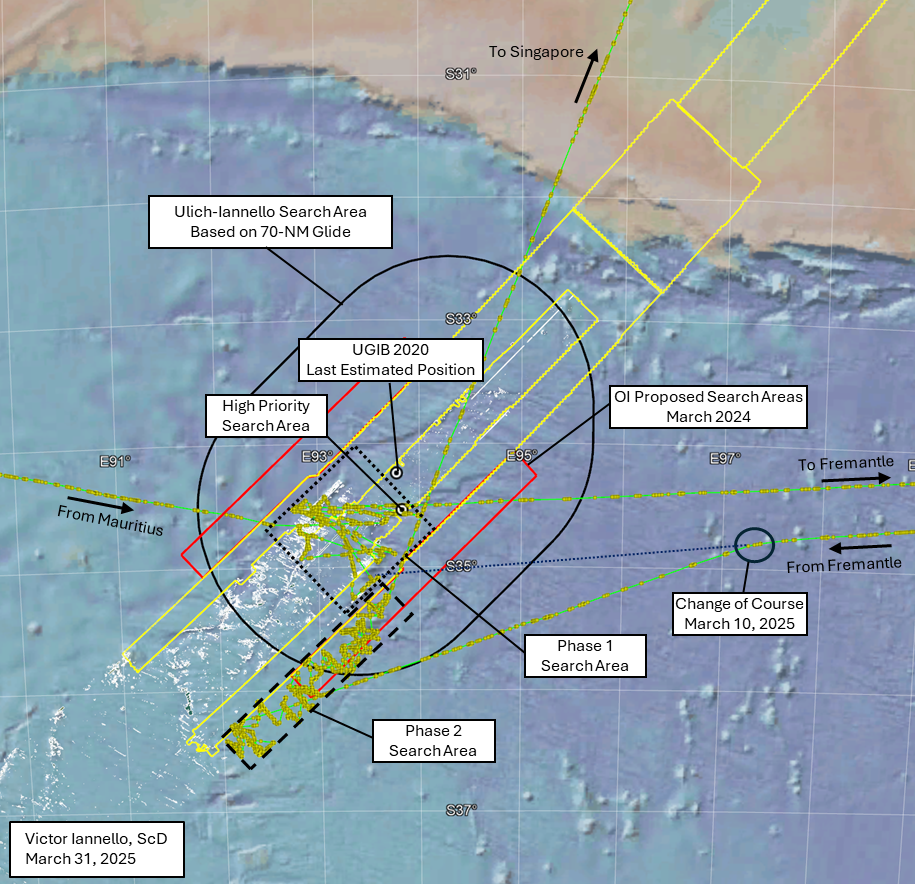
Last year, in March 2024, at a gathering in Malaysia on the 10th anniversary of the disappearance of MH370, family member V.P.R. Nathan presented several slides highlighting Ocean Infinity’s willingness to conduct another subsea search for the debris field of the aircraft. The search area proposed at that time extended along the 7th arc from about 33°S to 36°S, and out to about 45 NM (83 km) on either side of the arc. Ocean Infinity also announced plans to “fill-in” areas that were previously searched that had low quality or missing data due to equipment failures or challenging terrain. The proposed search area surrounded the “Last Estimated Position” (LEP) from UGIB 2020, which was designated the “IG Hotspot” in the slide. The proposed search area also incorporated our High Priority Search Area due south of the LEP that was missed by the previous searches by the ATSB and Ocean Infinity due to the steep sloping terrain in that area.

More recently, there were the following developments:

  • On December 20, 2024, the Malaysian government agreed “in principle” to a new search effort with Ocean Infinity, indicating the start of formal negotiations.
  • On March 19, 2025, Malaysia’s Transport Minister Anthony Loke announced that the Malaysian cabinet had agreed to the terms and conditions of the agreement with Ocean Infinity under a “no find, no fee” arrangement, with a payment of $70 million if successful.
  • On March 26, 2025, a group representing the families of MH370 victims announced that a no-find, no-fee contract was signed by Malaysia and Ocean Infinity. Despite this announcement, there has been no official confirmation from either Malaysia or Ocean Infinity.

In February 2025, with no signed contract in hand, Ocean Infinity began the search that was proposed the year before. After completing two phases of the subsea search, Armada 7806 and its team of three AUVs is now on course to Singapore. Prior to departing for Singapore, the activities conducted during the two phases can be summarized as follows:

Phase 1: After arriving in the search area after departing Mauritius, this phase of the search began on February 23 and was completed on February 28, before departing to Fremantle to reprovision and resupply. The areas searched during this phase (dotted black box in the figure above) were primarily areas previously searched by the ATSB and by Ocean Infinity. Consistent with Ocean Infinity’s proposal from March 2024, the Phase I activities focused on infilling data where challenging terrain such as steep slopes previously resulted in missing or low quality data (data holidays). As such, most of the area in the Phase 1 box was not re-searched. The areas searched in this phase included our “High Priority Search Area”.

Phase 2: After departing Fremantle, Armada 7806 began searching again on March 11 and continued until March 28, before departing for Singapore. The areas searched during this phase (dashed black box in the figure above) were never searched before, starting further southwest and wider than the area proposed by Ocean Infinity in March 2024 (red boxes in the figure above). This would suggest that Ocean Infinity intends to enlarge the search area from what was previously disclosed.

The reasons for Ocean Infinity concluding this part of the search appear to be related to worsening seasonal weather and also related to prior contractual commitments for Armada 7806.

An interesting event occurred during the return to the search area before the start of Phase 2. The course of Armada 7806 was originally towards a part of the area that was searched in Phase 1. Then, on March 10, there was a change in course towards the southwest to begin searching areas not previously covered.

If there was no change in course on March 10, the purple dotted line in the figure above shows where in the Phase 1 search area Armada 7806 would have reached. In fact, our prior article discussed the possibility that Armada 7806 was returning to a debris field that was detected during Phase 1. This area is shown in more detail in the figure below.

This image has an empty alt attribute; its file name is image-10.png

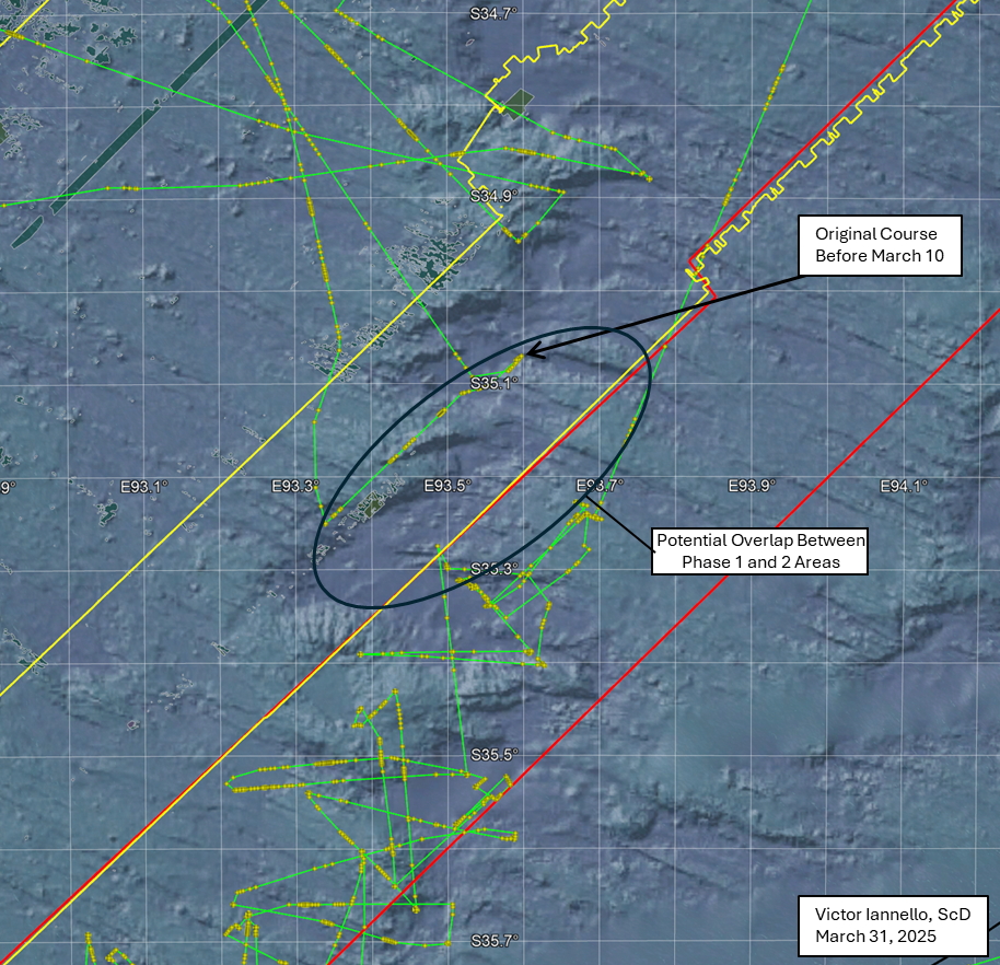
Shown in the figure by the black oval is an area that was possibly searched in both Phase 1 and Phase 2, which might mean a promising area required further investigation. However, as we don’t know the exact path that the AUVs followed after launching, there may have been little to no overlap between the Phase 1 and Phase 2 search areas.

So why did Armada 7806’s course change on March 10? Here are two possibilities:

  1. What resembled a debris field was found during Phase 1 and the plan was to revisit that area during Phase II to collect more data. Due to ongoing contract negotiations, OI strategically opted to not disclose the location of the debris field, and the course changed to the southwest. Some additional data in the area of the debris field might have been collected at the end of the Phase 2. (See the potential overlap area in the figure above.) If the debris field was already found, it is unknown whether Ocean Infinity has met the requirements to earn the fee of $70 million, which may require the retrieval of one or more parts of MH370.
  2. No semblance of a debris field was found during Phase 1. Originally the plan was to begin the Phase 2 search where Armada 7806 originally headed and then progressively search to the southwest. For some reason, the plan was changed on March 10 to begin the search to the southwest and progressively search to the northeast, ending where originally planned to begin.

In any event, if the debris field was not found, we are hopeful that Ocean Infinity will return to the search area in November, later this year.

Acknowledgement: This article benefited from ongoing discussions with Mike Exner, Don Thompson, Bobby Ulich, and Andrew Banks.

Tags: , , , , ,
Posted in Aviation | 242 Comments »

Is Armada 7806 Returning to the MH370 Debris Field?

After a day in port in Fremantle, Australia, to refuel and resupply, Armada 7806 is headed back to the MH370 search area. Based on an average speed of around 10 knots, it should reach there around 02:30 UTC on March 11.

There is a sign that this phase of the search will be shorter than expected: Armada 7806 is self-reporting through Automatic Identification System (AIS) marine tracking that its destination is Cape Town, South Africa. As this is considerably further from the search area than Fremantle, it would make no sense to travel to Cape Town and then return to the search area. A leg to Cape Town would also limit the time that Armada 7806 could spend in the search area, as the port-to-port time is typically less than four weeks.

So why might Armada 7806 be returning to Cape Town after visiting the search area. I offer three possibilities:

  1. During the last phase, something resembling a debris field was detected. If so, Armada 7806 might travel to this spot, launch one or more AUVs, and get better data, including possibly images. After a short time gathering this data, it might travel to Cape Town before it is reassigned a new mission. Another vessel with ROV capability would then be assigned to better document the debris field and perhaps recover some wreckage.
  2. There are ongoing contractual issues between OI and Malaysia and the search will be cut short even if no debris field is detected.
  3. The AIS destination is not correct, either due to an error or due to misdirection.

With the recent announcement by Malaysia saying that the search contract with Ocean Infinity is approved and the signing is imminent, it reduces the probability of (2). Once the contract is signed, we can almost completely eliminate this possibility.

If (3) is correct, we would expect that Armada 7806 would remain in the area for a number of weeks to collect more data and then return to Fremantle. If (1) is correct, the time in the search area will be short. So the length of time that Armada 7806 remains in the search area will tell us a lot.

It is difficult to assign relative probabilities to these three scenarios. Perhaps it is confirmation bias that I believe that (1) is most probable. In any event, we’ll know more in the coming days.

Steep Slope

We can zoom into where Armada 7806 is headed to see why this area might be interesting. Presently (and this could change), Armada 7806’s course is towards a steep slope that was searched with AUVs during the last phase of this search. This steep slope also lies within the areas scanned previously by GO Phoenix using a towfish during the ATSB-managed part of the previous search effort. Parts of this slope were also previously scanned by Ocean Infinity with the vessel Seabed Constructor and its team of seven AUVs. A return to this area once again highlights the difficulty in scanning terrain with steep slopes and other uneven topography, even with AUVs.

The part of the steep slope that seems to be the target is part of the same slope that we designated the High Priority Search Area (HPSA), but further south along that slope. At the time we identified the HPSA, we were not aware that so much more of the slope was not adequately scanned during OI’s last search. If the debris field is truly along this slope, our recommendation to fill-in the low quality data near the 7th arc before extending outwards from the arc was accurate. We said:

As the a) final BFO values, b) the lack of IFE log-on, and c) the end-of-flight simulations all suggest an impact close to the 7th arc, a high priority should be to scan the areas closest to the 7th arc that were either never scanned or have low quality data before searching new areas further from the 7th arc. However, with pilot inputs, it is possible that MH370 glided after fuel exhaustion beyond the areas that were previously scanned. Therefore, searching wider along the 7th arc should also be part of the search plan if areas closer to the 7th arc are unsuccessful in locating the debris field...A steep slope to the south of where UGIB predicts MH370 crossed the 7th arc happens to lie along the extended path of the reconstructed route, and much of this slope remains unscanned. For this reason, the unscanned area surrounding S34.52 E93.84 should be designated a High Priority Search Area.

Although we are speculating about what might take place next based on very limited information, the next several days could prove to be very interesting.

Tags: , , , , ,
Posted in Aviation | 280 Comments »

New MH370 Search Continues

Ocean Infinity (OI) has completed the first phase of its subsea search for MH370 in the Southern Indian along the 7th arc in the Southern Indian Ocean (SIO). As expected, Armada 7806, with its fleet of three autonomous vehicles (AUVs), is searching in the vicinity of the area proposed by OI in March 2024, generally between 34S to 35S latitudes. Armada 7806 is currently in port at Fremantle for refueling and resupplying. It is expected that the turnaround will take around a day, and that Armada 7806 will return to the 7th arc for the second phase of the search.

We know approximately what areas were searched based on the position of Armada 7806 as deduced by AIS reports transmitted via satellite and made available to the public via various marine tracking sites. However, the exact locations searched depend on the track followed by the AUVs after they are launched from the ship during their “sorties”, and this is unknown. Because launches and recoveries while the Armada 7806 is moving slowly or stopped, some additional information can be gleaned by the ship speed.

The figure below shows more details of the search area. Shown in the figure is the sonar data from the first search managed by the ATSB as contracted to Fugro and GO Phoenix (mixed brown shading), the outline (yellow) of the previous search conducted by OI using Seabed Constructor and its team of seven AUVs, and the outline (red) of new areas that OI proposed to search in March 2024. The tracks of Armada 7806 are shown by the circles and connected lines (purple), where the circles are representative of hourly position reports. Where the circles are clumped is indicative of either a launch or recovery of an AUV, which gives us some insight as to the areas searched.

The first location searched was the area we previously designated as the High Priority Search Area, which lies due south of where MH370 was estimated to have crossed the 7th arc, as presented in UGIB 2020. This lies at the border of where OI conducted its previous search. Other areas searched by Armada 7806 were either previously searched by the ATSB or OI. In some cases, Armada 7806 is searching in an area previously searched by BOTH the ATSB and OI.

The reason for re-searching these areas is apparent from the figure below, which includes the terrain features from bathymetry data and shows the spots in which the ATSB sonar data is poor quality, ambiguous, or missing (so-called “data holidays”), depicted as olive-green areas with white outlines. It is apparent that the search so far has focused on “filling in” the areas missed by previous searches, in particular where the terrain was challenging due to steep slopes. Although the AUVs have better ability to follow terrain contours in comparison to the towfish vehicles used by the vessels contracted by the ATSB, the steepest of slopes also present challenges to the AUVs.

Discussion

The search strategy to date is to progressively eliminate large areas that have the highest probability of finding the MH370 debris field. In our opinion, it makes sense to completely eliminate the areas closest to the 7th arc before proceeding outward from the 7th arc into areas not previously searched. The final BFO values at 00:19:29 and 00:19:37 suggest that at these times, MH370 was in a progressively steep descent of around 0.7g downward acceleration. It is possible that the pilot recovered from this dive and glided further from the 7th arc. After infilling the previous data, the search will likely continue into the new areas proposed by OI, which would at least partially consider the dive-glide scenario. Progressively eliminating large areas of seabed is more sensible than jumping between hotspots. Even the High Priority Search Area we recommended only represents an area that we believe has higher relative probability than other areas, but cannot considered to be a “high probability” area because of the many assumptions that were required to reconstruct the UGIB 2020 path.

Finally, we consider the search recommendation presented in Ulich and Iannello (2023), which included the provision for searching outward from the 7th arc to account for a 70-NM glide. This is shown by the black racetrack below, and includes most of the area proposed by OI to search. This would extend past the 15,000 km2 represented by the search area OI proposed in March 2024 (red outline). It would also include the search area recommended by Blely-Marchand, which surrounds 35.6°S, 93.1°E.

It is unclear whether OI will search other areas if the search in this area is unsuccessful.

Posted in Aviation | 81 Comments »