Political Friend of MH370 Captain Now Missing

An article published in Free Malaysia Today reports that Peter Chong, a close friend and fellow political activist of Captain Zaharie Shah, is now missing. Just days before his disappearance, he complained on Facebook that he was accosted by a motorcyclist and told to be careful as “nowadays a lot of people have suddenly disappeared”.

Mr. Chong and the captain were both active in the opposition party PKR, which is how they first met. The captain would reportedly spend eight or nine hours a day helping the political campaign when not scheduled to fly.

I include the contents of the article below. I hope that Mr. Chong is found quickly and is not harmed.

Missing Peter Chong a close Friend of MH370 captain

PETALING JAYA: Peter Chong, the activist who went missing last week after he had narrated an apparent veiled threat against him, is a close friend of pilot Zaharie Ahmad Shah, captain of the Malaysia Airlines flight MH370 that mysteriously vanished three years ago.

Chong had vigorously defended Zaharie against speculations of possible responsibility over the incident in several interviews with international and local media, in the weeks after the plane disappeared en route from Kuala Lumpur to Beijing on March 8, 2014.

He had also attended vigils and other events dedicated to the 239 people who were aboard the missing plane.

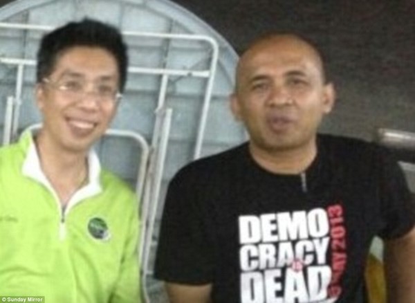
In one photograph that had gone public, the two are shown together with Zaharie wearing a t-shirt which reads “democracy is dead”.

Chong’s family reported to the police on Saturday evening that they had not been able to contact him after he was seen leaving the house on the night of April 5.

In a Facebook posting on March 31, Chong, who likes to attend protests and candlelight vigils, had narrated how a motorcyclist accosted him earlier that morning, telling him to be careful as “nowadays a lot of people have suddenly disappeared”.

Chong, 54, had told FMT, in an interview published on March 17, 2014, that he first met Zaharie at a community event in Subang in 2012 and they soon became best of friends.

“He joined in as a volunteer and he was there cleaning and arranging the chairs,” Chong recalled.

“I realised that I had never met this guy before so I introduced myself. He told me that he worked with MAS and it was only later that I found out he was a captain.”

They were both also involved in political activism as Chong was then assistant to PKR’s Subang MP Sivarasa Rasiah, while Zaharie, a life member of PKR, campaigned for the party in the last general election in 2013.

In the interview, Chong also praised Zaharie, expressing his utmost trust in the pilot, describing him as a man who loves to share with his close friends the joy of flying.

“If I were to choose a pilot to fly me in the future I’d still choose Captain Zaharie because he is a responsible and honest guy,” he said.

The former Petaling Jaya City Council (MBPJ) councillor had reportedly told The Australian that Zaharie would spend eight or nine hours a day helping in the election campaign when not rostered to fly.

Chong added that Zaharie was “angry at corruption and how the courts were being abused” to allegedly push politically motivated charges against PKR de facto head Anwar Ibrahim who is now serving a five-year jail sentence for a sodomy conviction.

In another interview with the BBC first broadcasted on March 10, 2014, Chong had recalled speaking to Zaharie about a week before MH370 disappeared, saying he appeared to be in good spirits.

“The whole nation and the whole world are waiting for answers,” he had said in the interview.

“What I feel cannot compare to what his family and the families of all the other passengers and crew are feeling.”

The same can now be said of Chong’s own family who are waiting anxiously for word on his whereabouts.

His disappearance comes in the wake of the suspected abductions of Pastor Raymond Koh, Amri Che Mat, Pastor Joshua Hilmy and his wife Ruth since November last year.

Clips from CCTV recordings showing Koh being abducted in a professional manner by a group of masked men on a public road in Petaling Jaya in broad daylight on Feb 13 have been widely shared via social media.

Chong had reportedly attended a recent vigil for Pastor Koh.

Electoral watchdog Bersih 2.0 had yesterday requested for an “urgent meeting” with the Inspector-General of Police Khalid Abu Bakar over the mysterious disappearances of the activists.

Update 1 on April 11, 2017.

An article published on BH Online  provides more details of the police investigation. I include the article below as translated from Malay to English by Google .

Police Investigating the Disappearance of Peter Chong

KUALA LUMPUR: Police looking into the disappearance activist Peter Chong, whether a foul or otherwise, after he was last seen at his residence in Bukit Ceylon here, 6 April.

This is because, the main focus of the Kuala Lumpur police contingent at the moment is to see whether the victim actually lost or disappeared for unknown reasons.

Chairman of the Kuala Lumpur Criminal Investigation Department, Senior Assistant Commissioner Rusdi Mohd Isa, said that at present it is still not able to confirm whether there is a criminal element in the case.

“Based on preliminary information we have received, the victim does not receive any element of criminal intimidation before she was reported missing, but there was no threat to him.

“However, the focus of our investigation and the investigating his disappearance done from various angles based on the information available,” he said when contacted BH, just now.

He said it was too early to say that Peter was abducted by certain parties but did not rule out the possibility he was hiding.

“We can not disclose any details for fear that can interfere with the investigation by a special team set up involving contingent Kuala Lumpur Dang Wangi police,” he said.

Rusdi said he is confident the loss of Peter does not have any connection with the disappearance of Father Raymond Koh, who was kidnapped by a group of men in Petaling Jaya on 13 February.

So, the Kuala Lumpur police have already stated that there was no criminal intimidation, despite Mr. Chong’s Facebook post in which he complained that a motorcyclist had warned him to be careful because others have disappeared. And the police are already confident that his disappearance has nothing to do with the disappearance of other political activists.

Hopefully the Malaysian police investigation is thorough and honest and not a whitewashing of the facts.

Update 2 on April 11, 2017

Peter Chong reportedly had recently attended a vigil for Pastor Raymond Koh, a socialist activist who was recently abducted. This chilling video shows the abduction of Pastor Koh, which involved seven vehicles and at least 15 individuals. The video shows just how well-orchestrated and professional the operation was.

In a related development, the Inspector General of Police (IGP), Tan Sri Khalid Abu Bakar, says the investigation into Pastor Koh’s disappearance is deadlocked because of the publicity surrounding the case, including the candle-light vigils. He angrily declares, “So once again I urge the media, individuals, and NGOs that want to get involved in kidnap cases, to shut your bloody mouths.”

Update 3 on April 12, 2017.

In a bizarre twist of events, in an article from the Malay Mail Online, the IGP is now claiming that Peter Chong was not abducted, and was photographed crossing the border into Thailand. The IGP threatened to take action against Mr. Chong if he staged his disappearance to appear as if he was abducted. The IGP also proposed that Mr. Chong might have fled the country to avoid debt. However, the IGP produced no evidence that Mr. Chong crossed the border, had staged his disappearance, or tried to avoid debt. Perhaps the evidence will eventually be released.

Here is the article in full:

IGP: ‘Missing’ activist Peter Chong in Thailand, not abducted

KUALA LUMPUR: Peter Chong, the former Petaling Jaya councillor, had crossed the Bukit Kayu Hitam border to Thailand on the day he was said to have gone missing.

Police today confirmed that immigration records and photos showed him crossing the border at 6.30am on Apr 7.

“We have immigration records and photos of him leaving the country. There is no record showing that he has returned to the country,” said Inspector-General of Police Tan Sri Khalid Abu Bakar.

He was speaking to reporters after attending the police monthly assembly hosted by the Criminal Investigation Department.

Khalid said police are working with its Thai counterparts to investigate Chong’s motive for leaving.

“We do not know what was his intention in showing as if he was abducted. But if his motive was to create panic in the country, police will take action against him.

“I hope he will contact his family to inform them of his condition.”

Khalid also clarified that police only investigated one out of five activists who were said to have been abducted, under Section 365 for kidnapping.

“Only the Raymond Koh case is being investigated under abduction. The other four, including Chong, were classified as missing person cases as there was no proof that they were abducted,” he said, adding there is no update on Koh’s disappearance.

Koh, 62, was abducted after a group of men stopped his silver Honda Accord along Jalan SS4B/10 in Petaling Jaya.

CCTV footage of Koh’s abduction went viral on social media, showing a professionally executed abduction involving more than 10 men in three black SUVs.

Before Khalid’s statement, questions had been raised on Chong’s disappearance as well. Chong had also posted a cryptic message on his Facebook page shortly before his disappearance.

Update 4 on April 16, 2017.

In article from the New Straits Times, we learn that Peter Chong claims that he traveled to Thailand to learn more about the abduction of Pastor Koh, was himself abducted, and later released. Thankfully, he is now safe and unharmed in Malaysia. It will be interesting to see how Mr Chong’s story squares with the scenario proposed by the IGP, in which Mr Chong staged his own disappearance and fled the country to avoid debt.

Here is the article:

KUALA LUMPUR: Peter Chong, the former Petaling Jaya councillor who re-emerged today after disappearing 11 days ago, has claimed that he was abducted while in Hat Yai, Thailand, where he had been all this time.

He told police that he had gone to Hat Yai to meet a source claiming to have information on the whereabouts of Pastor Raymond Koh Keng Joo, who was allegedly abducted in Petaling Jaya, on Feb 13.

However, upon reaching the southern Thai city, Chong claims he was abducted and taken north, to Pattaya.

He said he was abruptly released in Pattaya, where he contacted his son, Darryl, who arranged for him to fly home to Malaysia.

The identity of his abductor and the motive for his alleged kidnapping is unknown.

City police chief Datuk Amar Singh confirmed the details of Chong’s statement.

Earlier today, Inspector-General of Police, Tan Sri Khalid Abu Bakar, tweeted two pictures of the activist, believed to have been taken at the Kuala Lumpur International Airport (KLIA) at about 1pm.

“Congratulations @PDRMsia Kuala Lumpur. “Missing” Peter Chong is back from Pattaya, this afternoon,” the tweet read.

Khalid said police recorded Chong’s statement upon his arrival at the airport.

Chong went missing on April 6, in the wake of the alleged abduction of fellow activist, Koh. Chong’s family lodged a police report a day after his disappearance.

About a week before he disappeared, Chong left a cryptic post on his Facebook page which raised fears for his safety.

Posted in Aviation | 85 Comments »

Possible MH370 Descent over the Andaman Sea

View of cockpit during descent. The Nicobar Islands are in the left windshield. (Click to enlarge.)

Introduction

As readers here know, we have considered the possibility that MH370 turned to the south later than 18:40 UTC and crashed along the 7th arc to the north of the seabed that was searched. What led investigators in the past to believe that MH370 turned at some point between 18:28 and 18:40 are the satellite data obtained at times that bookend this time interval. If we assume that MH370 was flying at nearly constant altitude, the BFO value at 18:28 is consistent with a plane flying at 500 knots and on a track of 296°T, which puts it parallel to airway N571 around waypoint NILAM. Similarly, the BFO value at 18:40 is consistent with a plane flying at on a track of 180°T at about 462 knots. That means a turn to the south must have occurred during this time interval if the plane was flying at constant altitude. However, the BFO values at 18:40 also match a plane descending and maintaining a northwest track, which would imply a later turn to the south. Here we consider this possibility. In particular, we consider whether:

  • The combinations of groundspeed and vertical speed required to match the BFO at 18:40 are typical of a B777 in a descent
  • The variation in the BFO values recorded at 18:40 are what we would expect if MH370 was descending

BFO Values at 18:40 UTC

A log-on sequence to Inmarsat’s satellite network occurred between 18:25 and 18:28. The BTO and BFO data obtained during the log-on suggests that MH370 was flying parallel but to the right of airway N571, near waypoint NILAM.  Commenter @Andrew, a former B777 pilot, advised us that in the event that an aircraft does not have clearance to fly an assigned airway, a 15-NM offset from the airway is recommended to avoid other traffic. It is therefore possible that MH370’s pilot, knowing that the transponder was inoperative, chose to fly at 15 NM to the right of N571 to avoid other traffic.

At the time of the call at 18:40, if MH370 was flying offset from N571, it would have been just past waypoint IGOGU in the Andaman Sea and flying towards the Nicobar Islands on a track of 294°T. The call at 18:40 produced 49 BFO values that were recorded over a period of about one minute. The values ranged between 86 Hz and 90 Hz, and averaged 88 Hz. Using this average value of 88 Hz, we can determine the values of groundspeed and vertical speed that would produce a BFO value of 88 Hz for a plane flying along a track of 294°T. Knowing the groundspeed (GS) and vertical speed (VS), the BFO is calculated from the equation

BFO(Hz) = 128.8 + 0.0372 GS(kn) + 0.0228 VS(fpm)

A table of selected values of groundspeed and vertical speed that result in a BFO value of 88 Hz is shown below. Also shown in the table is the calculated flight path angle (FPA), which is the negative of the descent angle, and gives some indication as to whether drag or thrust is required to maintain a particular descent rate. In general, a descent angle greater than around 3.0° will require additional drag (by deploying the spoilers, for instance), and a descent angle less than around 3.0° will require thrust from the engines. A plane gliding with a descent angle of 3.0° has a lift-to-drag ratio (L/D) of around 19. We see in the table that for groundspeed between 450 and 500 kn, the descent angle is between 2.9° and 3.2°, and the vertical speed is between -2500 and -2600 fpm. This translates to typical descent angles.

Descent Conditions to Match the BFO Values at 18:40

Automated Descent of MH370

Because the BFO varies with groundspeed and vertical speed, any variation in either of these two parameters would be represented as a variation in the BFO values that were recorded. Using the BFO equation, we find that either a ±54-knot variation in ground speed or a ±88-fpm variation would produce a ±2-Hz variation in BFO.  For an automated descent, once established, it would be rare to see a 54-knot change in groundspeed over the course of a minute. However, a 88-fpm change in vertical speed is very possible, especially for descent modes in which the elevator is used to control either Mach number (M) or indicated airspeed (IAS). For this reason, we consider that MH370 was descending in an automated mode that minimizes the variation in vertical speed. In particular, we consider a “V/S” descent in which the elevator is used to maintain the selected vertical speed and the autothrottle is used to maintain the selected airspeed, i.e., the selected value of M or IAS.

The figure below shows the calculated values of BFO for a descent in which VS=-2600 fpm is held constant and the airspeed was selected as M=0.8. The calculations assume a headwind of 3 kn, a temperature of ISA+10.8K, and a ratio of 1.06 between the geometric and pressure altitudes, which is all based on the appropriate GDAS meteorological data. The assumed descent is between FL340 to FL200, and lasts for about 5.3 min. The BFO values are calculated assuming a bias of 151 Hz, i.e., the oscillator in the SATCOM has drifted up by 1 Hz in frequency from the time it was at KLIA. This small drift allows the calculated BFO to match the measured values of BFO with a value of VS that is a multiple of 100 fpm, which is the resolution of VS that is selectable by the thumbwheel on the Mode Control Panel (MCP) of a B777. In fact, we don’t precisely know the true value of the BFO bias, but a 1-Hz drift is possible.

Calculated and measured BFO data during the descent at 18:40.

Also shown in the preceding figure are all 49 recorded values of BFO at 18:40. The best-fit line of the BFO data indicates a trend with a slope of 0.4 Hz/min, corresponding to a variation of ±0.2 Hz about the mean over that 1-minute interval, while the measured variation in BFO is ±2 Hz about the mean of 88 Hz. From this, we conclude that there is no discernable trend in the BFO data over this 1-minute interval, i.e., the BFO values do not appear to vary with time. The ±2 Hz variation in the BFO data is therefore treated as noise.

For the first two minutes of the calculated descent, the airspeed is held at a constant M=0.8, and the IAS increases during the descent from its initial value of 278 kn. As the outside air temperature increases during the descent, the true airspeed (TAS) increases, which causes the BFO to rise at a rate of 0.2 Hz/min. This corresponds to a variation of BFO of ±0.1 Hz over the 1-minute interval of the recorded BFO data. This variation is much smaller than the value of ±2 Hz due to BFO noise.

After about two minutes of descent at M0.8, the plane reaches a pressure altitude of 29,000 ft (FL290), and the airspeed has increased to 310 kn. At this speed, the autothrottle automatically changes modes and begins to maintain a constant airspeed of 310 KIAS during the descent. The Mach number also begins to fall. Increasing air density during the descent causes a reduction of true airspeed with a corresponding reduction in groundspeed, and the calculated BFO changes at a rate of -0.6 Hz/min. If the descent was timed so that BFO data was recorded during the descent at 310 KIAS, the variation in BFO due to the descent would be ±0.3 Hz. Although higher than the variation in BFO during a descent at M0.8, the variation is still much lower than the ±2 Hz due to BFO noise.

It should be noted that when 310 KIAS is displayed in the speed window of the MCP, this value represents the minimum airspeed during the descent at VS=-2600 fpm. If the airspeed falls below 310 KIAS, the autothrottle would increase the thrust to restore the airspeed to 310 KIAS. However, if the speed increases past 310 KIAS and the thrust is already at idle, the speed can only be maintained if the pilot adds drag by operating the speed brake lever. If the speed brake is not used, then the airspeed will increase past 310 KIAS. The net effect of this increase in airspeed will be to reduce the rate of BFO from falling at -0.6 Hz/min. Since we are concerned here with the variation of BFO during the descent, modeling the descent at a constant value of 310 KIAS provides a worst case estimate of this variation.

Conclusion

The timing of MH370’s final turn to the south has an important impact on the estimated end point along the 7th arc. The later the timing of the turn, the further north the end point is predicted to be. Although the BFO values at 18:40 UTC recorded during a 1-minute interval suggest the plane was flying at constant altitude and had already turned south, an alternative interpretation is the plane was still traveling northwest but was descending. Here, we find that the combination of groundspeed and vertical speed that is required to match the BFO at 18:40 also corresponds to a typical descent rate of around 3°. We also find that over the 1-minute interval, the change in BFO that is expected due to this descent is small compared to the noise in the BFO values that were recorded. An autopilot mode that minimizes the variation in BFO is V/S at -2600 fpm.

Posted in Aviation | 465 Comments »

MH370 Families Launch Private Search Effort

Debris map from MH370 produced by the School of Civil, Environmental and Mining Engineering & The UWA Oceans Institute

Families of MH370 passengers and crew gathered on March 4 for the Third Annual Remembrance Event of the disappearance. As part of the three-hour event, Dr Charitha Pattiaratchi, a Professor of Coastal Oceanography from the University of Western Australia, presented “The Utilisation of Ocean Drift Modeling Techniques to Locate MH370”. According to a story by aviation writer Geoffrey Thomas, Dr Pattiaratchi said that UWA’s reverse-drift modelling puts MH370 “at Longitude 96.5 E Latitude 32.5 S with a 40km radius”.  This means his estimate is at the northern end of the new search zone recommended recently by the ATSB, which was between latitudes 32S and 36S, with a total area of 25,000 sq km, and with the highest probability at 35S latitude. Dr Pattiaratchi claims that UWA’s drift model is consistent with the recovery of 18 of the 22 pieces of debris found to date.

Also as part of the Remembrance Event was the announcement that Voice370, an advocate and support group for MH370 families, launched an effort to raise money to privately search for the aircraft. In a statement recently released, the group would like to search the “newly recommended 25,000 sq km”, which presumably is the same area recommended by the ATSB. The statement is careful to not cite the group’s fundraising goal, although in a previous Reuters story , Grace Nathan, daughter of MH370 passenger Anne Daisy, pegged the number at $15 million.

This blog is dedicated towards solving the mystery of the disappearance of MH370, and I fully support continued efforts to find the plane. However, I pose a simple question: “What level of confidence do we have today that the plane will be found in the 25,000 sq km of seabed now proposed?”

Updated on March 8, 2017

A recent interview with Dr Pattiaratchi appeared in The New Daily. Here is an excerpt from that article.

[Professor Pattiaratchi]  claims the research gives authorities the “credible evidence” required to restart the search.

“That’s as good of information as you can get from an oceanography point of view.

“There is absolutely no doubt about the debris that has been found.”

The ATSB spent almost two years searching a 120,000sqkm area in the southern Indian Ocean for MH370, an area the UWA model predicted would prove fruitless.

“As soon as the flaperon (part of the aircraft’s wing) was found, we were saying it was unlikely that the plane went down in the search area at that time,” Professor Pattiaratchi said.

“The ATSB did not take into account the debris that was found. And despite the flaperon being found on [Reunion Island in] July 2015, it took them until November 2016 – almost 18 months – for them to acknowledge [MH370] is not [located] where they were searching.

It is true that the ATSB and DSTG did not incorporate drift modeling into their analyses until fairly late in the game, and Dr Pattiaratchi’s remarks are going to cause them some embarrassment. But we also have to ask ourselves:  What part of the ATSB’s analysis was incorrect?

Posted in Aviation | 687 Comments »

Radar Maybe Captured Fighter Jet Chasing MH370

Radar data from MH370 and another possible aircraft. (Click to enlarge.)

As readers here know, we have been re-visiting previously held beliefs about MH370 to better understand why the underwater search failed to find the plane. The ATSB continues to believe the assumptions that it and the DSTG used to define the current search area were correct. But if these assumptions were correct, the probability of finding the plane where it was searched was very high. Either the search team was extremely unlucky, or some of the long-held assumptions are incorrect.

It is in the spirit of questioning assumptions that I present a new possibility regarding the military radar data of MH370 above the Malacca Strait: I consider that the captures recorded by the military radar installations might be from two aircraft rather than just from MH370, as I show in the figure above. The motivation for this inquiry is the following facts that taken together cause some concern:

  1. The radar data shown in the Lido Hotel image shows an aircraft following airway N571 at a speed of around 500 kn. The last radar capture is at 18:22:12 just past waypoint MEKAR. (All times here are UTC.)
  2. If MH370 continued following N571 after the last radar capture, at the time of the log-on at 18:25:27, it would be traveling on a track of 296T.
  3. The BTO sequence during the SATCOM log-on suggests that MH370 was not following N571 at 18:25:27 through 18:28:15. However, the final BFO value suggests the plane was flying at around 296T and 500 kn, which would put it roughly parallel to N571.
  4. It is possible that the pilot performed a lateral offset manoeuver of around 12 NM between the last radar capture at 18:22:12 and the log-on request at 18:25:27. However, the manoeuver would have to be fairly well-timed to fit in that period of about three minutes.
  5. If we ignore the military radar data after around 18:02, we can find paths starting from this time that match the BTO and BFO data without the need to invoke the lateral offset manoeuver, as shown in the last post.
  6. The ATSB reports that the military radar data supplied by Malaysia concludes with a position and time at 18:01:49, and then after a 20-minute gap, there is a single capture at 18:22:12. This contradicts the many captures shown in the Lido Hotel image during this 20-minute period. The DSTG also reports that the final radar capture at 18:22:12 was not used to reconstruct possible flight paths.

To investigate this further, I considered a version of the Lido Hotel image that was studied back in May 2014 by IG member Bill Holland, and shown below. Bill enlarged the high-resolution version of the photograph, and he noticed that there were timestamps printed to the right of the targets. (The timestamps refer to local Malaysian time, which is eight hours ahead of UTC.) Although the timestamps were blurred and overlapping, using a timescale that he superimposed as a guide, he could determine what the values were for some of the timestamps. From this, he deduced that the plane’s speed was around 500 kn.

Enlarged Lido Hotel radar image with timestamps added by Bill Holland. (Click to enlarge.)

But there are features in this slide that was never explained. For one, there is a capture at 18:07:06 whose position is about 7.5 NM off of MH370’s path, and also about 2.3 minutes later than the surrounding points. Because this capture doesn’t match the path suggested by the other captures, most of us have assumed it represent a false target, and we have ignored it. Another feature is that there is an explained “hole” in the radar coverage between around 18:07:06 and 18:12:30. The Malaysian officials thought this gap in coverage was important enough to draw a white circle emphasizing it.

We can see in the figure that the radar captures that are to the west of the “hole” lie along airway N571 between waypoints VAMPI and MEKAR. We also see that these captures align with the unexplained capture at 18:07:06, suggesting this may represent the path of a second aircraft.

We can also see that the paths of the two aircraft cross in the “hole”. Perhaps the gap in radar coverage is due to the radar’s inability to distinguish and positively identify each target due to proximity. The intersection of paths occurs near the center of this circle, although the aircraft would pass this intersection point at different times.

There are some other interesting aspects of this hypothesis about two aircraft captured by radar. The path of MH370 that is shown in the figure corresponds to a track of about 296T, which is roughly parallel to N571 after MEKAR, yet with an offset to the right from N571 that produces a good match with both the BTO and the BFO data at about 495 kn. So, this theory allows us to match the BFO and BTO data without invoking a precisely timed lateral offset manoeuver. MH370’s path is already spaced to the right of N571.

Another interesting aspect occurs when we extrapolate the path of the second aircraft backwards in time. Doing so, we find that the path crosses a point just to the south of Runway 18 of Butterworth Air Field near Penang. This raises the possibility that the second aircraft departed from from Butterworth and chased MH370.  Richard Godfrey discovered that this point to the south of Butterworth falls very close to waypoint UPTOP.

 We can estimate the speed of the second aircraft by considering the timing and positions of the radar captures that have timestamps of 18:07:06 and 18:13:30, which correspond to the unexplained radar point to the east of the “hole” and another capture after waypoint VAMPI to the west of the “hole”. The distance is about 77 NM, which would mean the second aircraft was flying with a groundspeed of about 722 kn. Assuming a temperature offset from standard conditions of about 14K, this corresponds to Mach 1.07 at sea-level, and Mach 1.21 at FL350. This tells us the second aircraft was not a civilian aircraft. The speeds, although fast, are certainly within the speed capability of modern military fighter jets, including one of the Boeing F/A-18D Hornets based at Butterworth Air Field.

We can also use the timestamps of the targets to the west of the “hole” to determine that the groundspeed of the second aircraft was around 500 kn after it caught MH370. This suggests that the two plane were flying roughly side-by-side, albeit with an estimated lateral separation of about 18 NM.

If this hypothesis considered here is true, it would answer some important questions about the radar data. But it would also raise even more questions about how Malaysia responded to MH370 after it disappeared from civilian radar screens and flew back across the Malay peninsula and above the Malacca Strait. If the theory is correct, it also would raise important questions about why Malaysia chose to keep this high-speed chase a secret.

Posted in Aviation | 169 Comments »

Possible Paths of MH370 in the Malacca Strait

Candidate MH370 paths starting from the same point at 18:02. (Click for a larger image.)

MH370’s SATCOM initiated a log-on to Inmarsat’s I3F1 satellite at 18:25:27, and after some exchange of data, completed that log-on at 18:28:15. (All times are UTC). The log-on process provides us with additional BTO and BFO data points which can help us to understand what the path and speed of the plane was at this time. Many of us have long assumed that the plane’s track just before the log-on was 296°T and the groundspeed was around 495 kn for two reasons:

  • These values are consistent with the position and timing data that we extracted from the often-discussed Lido Hotel radar slide, which was presented to the NOK in Beijing on March 21, 2014. The slide shows radar captures of an unknown target (suspected to be MH370) up until 18:22 along the N571 airway traveling at about 495 kn.
  • This combination of speed (495 kn) and track (296°T) matches the first and last BFO values (142-144 Hz) surprisingly well.

However, there are two problems with this theory:

  • Between the initial and final values of around 143 Hz, the BFO peaks at 273 Hz and decays to intermediate values of around 174 Hz before returning to 144 Hz.
  • If we assume the last recorded radar position at 18:22 is correct, then the BTO values during the log-on don’t match a plane traveling at a constant 495 kn along N571.

Back in July of 2015, some of us proposed an explanation that reconciled the radar, BTO, and BFO data: Soon after MH370’s SATCOM requested the 18:25 log-on to Inmarsat’s I3F1 satellite, the pilot initiated a 12-NM lateral offset manoeuver to the right of airway N571. (A pilot flying a leg of a route can program a lateral offset of a specified distance and the offset manoeuver will be automatically performed and the offset automatically maintained.) If the offset was timed just right, i.e., initiated just after 18:25:27 and completed just before 18:28:06, the BTO data matches, and all but the peak BFO value of 273 Hz can be explained. Most of us attributed this unexplained peak in frequency to a SATCOM anomaly that was not disclosed by its manufacturer (Honeywell Thales). With nothing better, we chose to ignore it.

We have gained more knowledge now that Ian Holland published his paper that discusses BFO behavior of a SATCOM as it logs-on to a satellite after it has been previously de-powered. Dr. Holland’s analysis suggests that the BFO sequence observed at 18:25 was not caused by a turn sequence taking place during the log-on. Rather, the BFO sequence is consistent with a SATCOM that has been de-powered for some time, warms-up, and logs-on to a satellite. As the oscillator crystal in the Satellite Data Unit (SDU) approaches it operating temperature, there is a peak in frequency followed by a decay to its final value. (Some like Mike Exner, Henrik Rydberg, and others have long suspected this.)  So now the unexplained peak of 273 Hz is explained and verified as repeatable.

Although the warm-up transient adequately explains the BFO sequence at the 18:25 log-on, it still doesn’t explain the BTO sequence, which is not consistent with a path along N571 at 495 kn between 18:25:27 and 18:28:15 that includes the recorded radar position at 18:22.

We have some additional clues from the report on MH370 released in December 2015 by Australia’s Defense Science and Technology Group (DSTG). As part of the investigation of MH370’s disappearance, Malaysia supplied the ATSB with the raw radar data up until the last capture at 18:22:22 with a  10-second spacing. However, no radar data was supplied between 18:01:49 and 18:22:22, and no explanation was provided for the 20-minute gap. If we are to believe there were no radar captures in this period, we should also question the validity of the data shown in the Lido Hotel radar image. This in turn calls into question whether MH370 was following airway N571 at the time of and subsequent to the final radar capture.

If we remove the constraint that MH370 was following airway N571, we can consider other candidate paths using the following methodology:

  • The path of MH370 that was captured by radar can be approximated by starting at a known position before 17:21 and integrating the groundspeed and track data provided graphically in the DSTG report. (Despite numerous requests, Malaysia refuses to release the actual radar data.)
  • Starting at the radar-derived position at 18:02 and lasting through the 18:25 log-on, we assume that MH370 proceeded along a great circle path towards a selected waypoint at constant ground speed. The effect of variations in wind and temperature are ignored for now. (In fact, the temperature variation is small and the groundspeed differs from the true airspeed by at most several knots, which is within the margin of error of this analysis.) Several candidate waypoints are considered, each producing a different initial track at 18:02.
  • For each initial track, a speed is determined by minimizing the RMS error of the BTO values at times 18:27:04 through 18:28:15 where the expected standard deviation is 29 μs. For the BTO at 18:25:27, the expected standard deviation is higher at 62 μs and was not used.
  • For the BFO, only the BFO value at 18:28:15 is considered, as the prior values are distorted by the warm-up transient, as advised by Dr. Holland.

The candidate paths are shown in the figure above, and the results from the analysis are shown in table below. The paths fan outwards from the recorded radar position at 18:02. It can be seen in the figure that as the initial track rotates towards the north, the path length required to reach the 18:28 arc increases, which translates to higher speeds, and also higher BFOs.  Therefore, not all of these paths satisfy speed and BFO criteria. A discussion of the candidate paths follows.


Case 1. Path towards the last radar point at 18:22 that minimizes BTO error

This is the baseline case considered in the DSTG report as the initial track of the path connecting the 18:02 and 18:22 radar positions is close to the observed radar track at 18:02 (around 289°T). The BTO error is minimized at a groundspeed of 459 kn, requiring a reduction in speed of about 59 kn, which is possible. (A pilot could choose to decelerate by climbing or using spoilers, which would drastically reduce the time to reach the new speed.) The BFO error at this speed is 6 Hz, which is acceptable by most measures. However, the distance and timing between the two radar points requires a minimum speed of around 499 kn, which would mean that the 18:22 radar point was in error by about 14 NM. So, considering this error and the absence of acknowledged radar data between 18:02 and 18:22, there is justification to completely ignore this last radar point, just as the DSTG chose to do in its analysis. Therefore, in the remaining cases analyzed, the last radar point at 18:22 is ignored, and we accept the 18:02 radar point as the last recorded position. Ignoring the last radar point doesn’t invalidate this path. It just makes it less special.

Of course, if we ignore the last radar capture, it once again begs the question that Malaysia refuses to answer: What data was actually shown to the NOK at the Lido Hotel in Beijing on March 21, 2014?

Cases 2,3,4,5. Paths towards airports that minimize BTO error

Recognizing that the radar data suggests that MH370 flew near (but not exactly over) Kota Bharu and later Penang Airports, we consider the possibility that after passing Penang, the plane was flown towards another airport in the region. We consider candidate paths towards Port Blair, Car Nicobar, Sabang, and Banda Aceh Airports, and for each path, find the speed that minimizes the BTO errors. As can be seen in the table, only the path towards Car Nicobar has an acceptable BFO error (3 Hz) and an acceptable speed (518 kn). This speed is consistent with what was observed by radar around 18:02. It’s also very fast compared to typical cruise conditions, corresponding to (no-wind conditions) of about Mach = 0.87 at FL350 at a temperature offset from standard conditions of around +10K. Although this Mach number is within the performance limitations of the plane, if MH370 flew along this path, it has important implications on the achievable endurance and range.

Case 6. Path that minimizes BTO error and exactly matches BFO

For this case, we allowed both the track angle and speed to vary as the BTO error was minimized and the BFO at 18:28:15 was constrained to match exactly. The calculated groundspeed is 499 kn, which is closer to a more typical speed that maximizes fuel efficiency.  The path crosses the 18:28 arc about 33 NM to the north of the ATSB’s baseline path towards the 18:22 radar point.

Summary

The radar data presented to the NOK at the Lido Hotel in Beijing on March 21, 2014, has been used by independent investigators to justify a path along airway N571. Recognizing that the radar data has never been officially acknowledged by Malaysia, and also recognizing that the radar data from that image was never provided to the ATSB by Malaysia, we have to question its validity. Strangely, the final radar point at 18:22 from that image was provided to the ATSB, despite the 20-minute gap between it and the proceeding capture at 18:02. By choosing to ignore this final radar point, MH370 is much less likely to have followed N571, and other candidate paths along great circles can be found that satisfy the BFO and BTO data at the 18:25 log-on. The path that arguably best satisfies the satellite data crosses the 18:28 arc 33 NM to the north of the path that includes the 18:22 radar point. There is also an acceptable path that leads to Car Nicobar Airport, which requires a speed about the same as was observed before radar coverage was lost at 18:02.

Update on 2/22/2017: Incorporated some small edits based on private comments from Mike Exner.

Posted in Aviation | 396 Comments »

More Analyses of MH370 Data

Predicted location of debris in July 2015 from a crash site of 30S latitude along 7th arc

In the past week, there were two serious technical papers released that discuss evidence surrounding MH370 and with implications on where it may have crashed along the 7th arc.  The two papers demonstrate that there is still significant disagreement about how to interpret some critical technical data.

In the first paper, entitled “The Probable End Point of MH370”, IG member Richard Godfrey concludes that MH370 most likely crashed along the 7th arc at 30S latitude, which is well north of where the seabed was searched.  Richard uses the extensive drifter data from the Global Drifter Program to develop a comprehensive drift model. He organizes and analyzes the drifter data, which includes the position, speed, direction, and water temperature measured by the drifters at 6-hour intervals, and he groups the data by position and calendar month. By introducing an “efficiency factor”, Richard relates the straight-line distance traversed by a drifter over 60 days compared to the total path length calculated from the 6-hour data and integrated over the same 60 days. Richard uses the derived speeds, directions, and efficiency factors to estimate the trajectory of debris that originates from the 7th arc in March. By incorporating the variability of efficiency factor that was experienced by the drifters, Richard calculates and presents the considerable dispersion of debris released from the same starting position along the 7th arc. Richard also relates the predicted temperature history of the debris to the observed barnacle populations on the debris. Richard concludes:

The drift analysis appears to support a probable end point of MH370 around 30°S near the 7th Arc. This fits with a late final major turn south at 19:36 UTC and a flight at the normal cruise speed of 0.84 Mach until fuel exhaustion. There is a good fit to the satellite data and a good fit to a great circle path toward Wilkins Runway (YWKS) as the final waypoint.

The drift analysis also explains the reason why MH370 floating debris originating around 30°S near the 7th Arc could end up in Reunion and South Africa with barnacles via tracks that pass through sea water between 19°C and 25°C and end up in Madagascar, Mozambique and Tanzania without barnacles via tracks that pass through sea water above 25°C.

The second paper, authored by Ian Holland of Australia’s Defense, Science, and Technology Group (DSTG), is entitled “The Use of Burst Frequency Offsets in the Search for MH370”. The paper presents the general methods used to calculate the BFO for reconstructed paths, but the real importance of the paper lies in the conclusions drawn from the BFO sequence at three critical times, which I paraphrase as the following:

The BFO sequence at the log-on at around 18:25Z is consistent with the BFO sequence that was measured for six previous log-ons of the 9M-MRO aircraft after a power down of 35 minutes or more. For MH370, the BFO values starting at 18:25:27Z and ending at 18:28:15Z were 142, 273, 176, 175, 172, 144, and 143 Hz. The decay from 273 Hz to 143 Hz is consistent with the decay in BFO values observed six previous log-ons, while the first value of 142 Hz is not. The author advises us to reject the initial value of 142 Hz because of the lower carrier-to-noise density ratio (C/No) and the non-zero bit error for that data point, which suggests that MH370 was flying at constant speed, track, and altitude during the log-on sequence. It also implies that the statistical equivalence of the first and last values is coincidental. No attempt is made in the paper to reconcile the measured BTO sequence with this interpretation of the BFO sequence (constant speed, track, and altitude).

MH370 should lie close to the 7th arc because the BFO sequence at the final log-on at around 00:19Z is consistent with a steep descent. Two hypothetical cases were considered: A log-on after a power down of several minutes, and a log-on after the SATCOM experienced an outage of communication not related to a loss of power. Considering these two cases, and also accounting for the possible contributions to BFO error caused by the decay in BFO values after a power down and the BFO error caused by drift of the SATCOM’s oscillator, the upper and lower bounds on the descent rate of MH370 were estimated. At 00:19:29Z, the descent rate is bounded between 2,900 and 6,800 fpm. At 00:19:37Z, the descent rate is bounded between 13,800 and 17,600 fpm.

The BFO values at the time of the call attempt at 18:40 suggests the aircraft had already turned to the south. As shown in the figure below, the BFO sequence between 19:41Z and 00:11Z, inclusive, matches a trend line that is consistent with straight and level flight. If this line is extrapolated back to 18:40Z, the author says there is rough agreement with the BFO value at 18:40, which implies that at this time, the plane was already on its straight and level path to the south. The author makes this conclusion despite the approximate 10-Hz discrepancy between the trend line and the BFO value, which is left unexplained.

Measured BFO from MH370 flight showing linear trend

The two recent papers demonstrate two sensible but different interpretations of the same set of data. If we are to accept the conclusions in Ian Holland’s paper, then the range of latitudes of the underwater search area was properly defined, and the aircraft should have been found close to the 7th arc. Why the aircraft was not found remains unexplained. On the other hand, Richard Godfrey, both in his recent paper and in a previous paper he co-authored with me, challenges the assertion that the BFO at 18:40Z unequivocally demonstrates that MH370 was flying south at that time.

As we attempt to explain why the underwater search has failed, the two papers demonstrate the importance of challenging some long-held assumptions. The difference in interpretations of the two authors is yet another demonstration of why it is imperative that the authorities release all the available information related to this case.

Update on 2/18/17: The deviation from the trend line was corrected to 10 Hz.

Posted in Aviation | 206 Comments »

Singapore Radar and MH370

A G550-EL/W-2085, an Israeli airborne radar system operated by the Republic of Singapore Air Force

Investigation officials have stated that the last radar capture of MH370 was a target in the Malacca Strait about 10 NM past waypoint MEKAR on airway N571, recorded at 18:22:12 UTC. Unfortunately, this last capture occurred before MH370 made its final turn to the south. The location and timing of this turn has been the subject of much debate because it has a significant impact on where MH370 crossed the 7th arc, and therefore it is important in defining the underwater search area. If we assume the aircraft was flying level after the log-on at 18:25 UTC, then the BFO data tells us the turn to the south must have occurred no later than 18:40 UTC. However, if we are open to the possibility that MH370 was descending at 18:40 UTC, then the turn to the south might have occurred after 18:40 UTC.

In the ATSB report released on June 26, 2014, we learned that there might have been other radar sources in the area that could give us hints about the path of the plane. There is the statement “The aircraft passed close to a NW point at 1912”. However, the report gives no indication of where that radar source was located, and whether there was a definitive capture. Because any radar captures after 18:22:12 UTC would provide important clues about the final path, there is interest in learning more about this “NW point”.

Researcher Dr. Niels Tas asked the ATSB about the NW point, and received the following reply: “The NW point at 1912 was an assumed theoretical location at 8° 35.719’N, 92° 35.145’E initially chosen to provide clearance from the known radar sources (mainly Singapore). A line from IGREX to the 1912 point was used as an upper bound for the airplane performance work after loss of radar contact (the min flight distance would be turning south right after loss of radar). This point did not affect the Doppler analysis, just the fuel burn, which affected the range measurements. Analysis had included using the upper bound (IGREX/1912 point) and the lower bound (direct from the 1822 point)…”

This response provides us with some clues about the radar source. First, we have a precise position for the NW point, which puts it in the Indian Ocean to the west of the Nicobar Islands, and about 15 NM to the right of a plane traveling along airway N571 between waypoints IGOGU and LAGOG. Second, we learn that the radar source is an asset of Singapore. Because Singapore is about 800 NM from the NW point, it is impossible that the radar installation is land-based in Singapore. If not land-based, it is mobile, and possibly airborne.

It is well-known that Singapore has significant airborne radar capabilities. In 2012, Singapore announced that an additional four Airborne Early Warning and Control (AEW&C) aircraft were operational, to complement the first it has fielded in 2009. These G550-EL/W-2085 aircraft were purchased from Israel, and are Gulfstream 550s fitted with phased-array radar. The reported range is 200 NM.

I asked the ATSB for more information about the NW point. Because the radar source is a military asset, much of the information is protected. However, I was able to learn that the NW point was shared by a member of the Joint Investigation Team (JIT), which consists of personnel from Malaysia, Australia, China, the UK, the US, and France. The NW point is not an actual radar capture, but was used in early path models as the latest time and position for the turn to the south. Basically, if the turn had occurred to the northwest of this point, it would have been detected by the radar source. I also learned that this radar source had no coverage of the Andaman and Nicobar Islands. Finally, I learned that this radar source had no coverage of any of the high probability paths predicted by the ASTB.

I was interested in determining where the airborne radar might have been, and whether the lack of radar captures might help us exclude certain paths that would fall within its range. In particular, I was interested to know whether the lack of detection might preclude a path between Car Nicobar and McMurdo Station. I proceeded with the following assumptions:

  • There were no radar captures after 18:22:12 UTC.
  • The range of the airborne radar was 200 NM.
  • The NW point is at the limit of the range of the airborne radar.
  • The airborne radar was in a tight holding pattern and never was very far from a fixed location.
  • All of the Andaman and Nicobar Islands were beyond the range of the airborne radar.
  • A path reconstructed with a turn at 18:40 UTC (the latest turn considered by the ATSB) would be beyond the range of the airborne radar.

The results from the analysis are shown in the map below. A circle with a radius of 200 NM defines all possible points at the range limits of the radar. Therefore, the position of the airborne radar would be somewhere along this circle. Possible radar positions that satisfy the criteria listed above fall on an arc between the red and green stars. Points to the northeast of the red star would have allowed radar coverage of portions of the Andaman Islands. Point to the southwest of the green point would have allowed radar coverage of some of the high probability paths reconstructed by the ATSB.

Range of possible positions of the Singapore airborne radar

If the radar source was located at the orange star or to the south, MH370 would have been seen if it followed a path between Car Nicobar and McMurdo Station. However, radar positions along the arc to the north of the orange star would not have seen MH370 if it traveled along this path.

It’s therefore possible that if an airborne radar source was circling about a fixed location somewhere along the white arc between the orange and red stars, it would not have seen MH370 if it flew towards McMurdo Station.

But here’s a related question: Why was Singapore possibly operating an AEW&C asset in the Indian Ocean to the west of the Andamans and 800 NM from Singapore?

Posted in Aviation | 40 Comments »

Why We Need Data Withheld by Malaysia

Radar data shown to MH370 families but never released.

It’s now almost three years since the disappearance of MH370. After an exhaustive underwater search in the Southern Indian Ocean (SIO) of around 120,000 square kilometers, we are still unable to locate the fuselage of the aircraft. The main evidence we have to locate the wreckage are the communication signals between the aircraft and a ground station in Perth, relayed by an Inmarsat satellite in a geosynchronous orbit above the Earth. From these signals, assuming they have not been manipulated, we do know that MH370 turned south and ended its flight along an arc in the SIO we now call the “7th arc”. We have also recovered debris from the crash that has washed up on the shores of several countries in Eastern Africa. Although the satellite data and the timing and location of the recovered debris support the theory that aircraft terminated in the SIO, they do not provide enough precision to locate the aircraft.

In order to estimate where MH370 lies in the SIO, a number of us, including the official investigative team and we in the MH370 Independent Group (IG), have used mathematical models to reconstruct paths that replicate how MH370 might have been flown. These models incorporate a number of assumptions, some of which we can be fairly certain are correct, and others that we are less certain about. For instance, assumptions about the performance of the aircraft, including minimum and maximum speeds, fuel consumption, and autopilot behavior, are all fairly well known. Other assumptions about the “complexity” of the path are less known. There are some that maintain that the simplest of reconstructed paths, i.e., paths with the fewest numbers of changes in speed, direction, and altitude, are the most likely. In fact, the current underwater search area is derived from this assumption. But with the failure to find the wreckage, it is time to re-evaluate this assumption. After all, the aircraft did not follow a random path. Rather, the aircraft likely was actively flown by the pilot (or pilots) at least until it made the final turn towards to the SIO. If the diversion was intentional, then there was a reason for the pilot choosing to fly along the particular path. As a result, models that reconstruct the path using a series of random events are likely to fail because they do not account for the motivation and intentions of the pilot.

If we are going to consider complicated paths that might include turns, holding patterns, changes in speed, and descents, the search area grows to an unmanageable size. We therefore have to introduce other assumptions and/or constraints to limit the size to something searchable.

Fellow IG member Richard Godfrey and I recently wrote a paper in which we predict a crash site for MH370 using certain data found on Captain Zaharie Shah’s home simulator. The simulator data include six position coordinates from a flight the Captain created using Microsoft Flight Simulator. The positions first show the aircraft on the runway at Kuala Lumpur International Airport, and then progressively airborne in the Malacca Strait, the Andaman Sea, and the SIO. The simulation ends with the aircraft running out of fuel in the SIO. Recognizing that the positions in the Andaman Sea and the SIO align with an ice runway at McMurdo Station, Antarctica, Richard and I hypothesize that the Captain used this same final waypoint when he programmed the flight computers of MH370. By combining this final waypoint with the available satellite data, we predict a terminus on the 7th arc well north of the current search. This theory also predicts that the aircraft entered a holding pattern near Car Nicobar Airport in the Andaman Sea before turning towards the SIO.

The failure of the underwater search and the modeling work of Richard and me shows the importance of using all the available evidence in defining possible crash sites. However, much of the evidence has never been made public. For instance, the data obtained from the Captain’s computer was from a secret Royal Malaysia Police (RMP) report that was never officially released. We are only aware of it because the report was leaked to French media organizations.

Australian reporter Marnie O’Neill recently asked fellow IG member Don Thompson and me to make a list of what important evidence was being withheld, and she used this as the basis of a story for news.com.au. Here are some examples of how Malaysia is showing that it is not fully committed to the finding MH370:

Inadequate Response to Disappearance

  • After the disappearance, there were only two attempts to reach MH370 using SATCOM voice (18:40 and 23:14 UTC).
  • There was no attempted military air intercepts as MH370 turned back and flew across the Malaysian peninsula despite plane detection by military radar in real time.
  • There was a delay of four hours after the disappearance before search and rescue (SAR) efforts began.
  • There was a delay of four days (March 12, 2014) before search shifted from South China Sea to Indian Ocean, despite having radar data.

Denied, Omitted, or Ignored Data

  1. Radar captures of MH370 in the Malacca Strait were shown to the victims’ families in Beijing on March 21, 2014, but radar captures between 18:02 and 18:22 UTC were never shared with the ATSB. (See figure above.)
  2. The partial data set of raw radar data made available to the ATSB was never shared publicly.
  3. The ATSB report released in June 2014 includes statements about a radar capture of MH370 at 19:12 UTC in the Andaman Sea. Later, the ATSB acknowledged the data to be from Singapore radar, and considering the distance from Singapore, likely was from an aircraft with radar capability operating in the Malacca Strait or Andaman Sea. No mention of this data is included in the Factual Information released in March 2015, yet if this data exists, it would place the terminus in the SIO much further north than where MH370 was searched.
  4. The existence of telephone records indicating a connection of the First Officer’s cell phone to a tower on Penang Island was first denied by Malaysia and not included in the Factual Information report released on March 2015. The secret RMP report has detailed information about this connection.
  5. The simulator data recovered from the Captain’s computer suggest a simulated flight with points in the Andaman Sea and the SIO. Malaysia first denied the existence of this data and did not include the data in the Factual Information report released in March 2015. The secret RMP report included some information about the simulator data, but the details about how the data was extracted and analyzed are unknown.
  6. The secret RMP report documents WeChat activity on the Captain’s cell phone while MH370 was lined up on the runway, only one minute before takeoff. The details of this activity are not presented in the RMP report. No mention of this data was included in the Factual Information report released on March 2015 despite its extreme relevance.
  7. Malaysian authorities have shown no timeliness in retrieving possible MH370 debris recovered from the shores of Eastern Africa.

As Don said in the article, “My own ‘hot button’ is that military long-range air defence surveillance data from assets operated at seven, possibly even eight, sites across four nations is absent from the data set available to ATSB.”  Don explains that “[t]hose [sites], all within range of the flight path MH370 is believed to have taken, are located at Lhokseumawe, Sabang/Pulau We and Sibolga in Indonesia; Car Nicobar and Port Blair in the Indian Andaman Islands; Khok Muang and Phuket in Thailand; and Western Hill, Penang, Malaysia. Any one of them, or all collectively, could provide the vital clues to the plane’s whereabouts.”

If we have any hope of re-starting the search for MH370, we need all the available data so that we can properly constrain the models we use to predict the terminus. The time for Malaysia to release all it has is long overdue.

Posted in Aviation | 91 Comments »