ACARS Message Paths ( From “Analyzing Security Breaches in ACARS”, Smith et al., 2017)
Fellow MH370 Independent Group members Don Thompson and Richard Godfrey have found some anomalies in the message logs that were included in Factual Information (FI) released by Malaysia on March 8, 2015, and the Safety Investigation Report (SIR) released by Malaysia on July 30, 2018. The logs from these two reports document the communication between MAS Operations Dispatch Center (ODC) and service providers that route messages over SATCOM and VHF paths, as part of the Aircraft Communications Addressing and Reporting System (ACARS). The anomalies suggest the traffic logs appearing in the reports are not complete, and what appears in the reports has been modified.
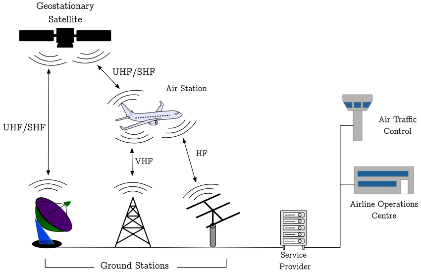
A simplified schematic of the ACARS is shown in the figure. For MAS, the service provider for satellite communications is SITA using the Inmarsat network and the service provider for VHF communications is ARINC using a network of ground stations.
Missing Messages Between 18:15:23 and 18:43:33
According to text in both the FI and the SIR, an urgent message from MAS ODC was submitted at 18:03 and then re-transmitted multiple times:
The first message sent to the aircraft cockpit printer from the MAS ODC was at 1803:23 UTC. The ACARS message requested the crew to contact the HCM ACC immediately. The incoming downlink message at 1803:24 UTC showed the message failed to reach the aircraft. Messages are auto transmitted every 2 minutes and the message was retransmitted until 1843:33 UTC but all messages failed to get a response. Automated downlink message by ACARS showed ‘failed’.
However, the last message from MAS ODC that was shown in both the FI and SIR traffic logs occurred at 18:15:23, and not the 18:43:33 stated in the text. This means that either the explanatory text is wrong, or the traffic logs do not contain all the message traffic.
VHF Messages Not Included
The missing messages could be explained if they were routed via the VHF link. For the ACARS traffic log in the FI, the filter parameters used to extract the message records included only SATCOM traffic for the time period 12:48:00 to 20:00:00, so that if any VHF messages were exchanged, those messages would not be included in the traffic log. (The filter parameters appear at the top of each page of the traffic log in Appendix 1.9A.)
The facts surrounding the ACARS traffic log in the SIR (also Appendix 1.9A) are more suspicious. For Page 1 of the log, the filter parameters did not limit the messages to only SATCOM messages. In fact, at 15:54:31, there is a message submitted by MAS ODC over the VHF link that requests personnel on the aircraft to re-configure the center VHF radio so that future messages would be exchanged via SATCOM. However, starting with Page 2 of the report, the filter parameters used to generate the remaining pages of the report were changed so that VHF messages, if any occurred, were excluded.
The change in filter parameters after Page 1 is unexplained. Two messages received by MAS ODC at 15:54:41 and 15:54:53 appearing at the bottom of Page 1 are repeated at the top of Page 2. The change in filter parameters and the repeated messages are clear evidence that the traffic log in the SIR is actually two reports that were pieced together and presented as a single report.
Edited Text
As it appears in the ACARS traffic log in the SIR, the text message that was sent by MAS ODC at 18:03:23 is:
URGET [sic] REQUEST
PLS CONTACT HO CHI MING [sic] ATC ASAP
THEY COMPLAIN CANNOT TRACK YOU ON THEIR RADAR
I RECEIVED CALL FROM SUBANG CENTRE
PLS ACK THESE MSG
REGARDS
However, the last line of the message appears to have been edited. By examining the ASCII characters embedded in the PDF version of Appendix 1.9A, the following text can be extracted:
REGARDS
MXXXXX
where MXXXXX is an actual name with six letters beginning with M.
There is also a misplaced © symbol on the bottom of the page that appears after the report page number on Pages 2 and later, but properly appears before the name “SITA” on Page 1. This is yet another indication that the traffic log in the SIR was edited.
Request for Complete, Unmodified ACARS Logs
It is disappointing that more than four years after MH370’s disappearance, we are still asking Malaysia to release withheld data. The military radar data is another example of a data set that has never been released in full despite its significance in providing information about how the aircraft was flown after the diversion from the flight plan.
It is important that Malaysia provide a complete, unmodified log of all ACARS communications on SATCOM, VHF, and HF paths for the period between 12:48 and 20:00 on March 7, 2014. This is particularly significant in light of questions surrounding the delayed response of Malaysian authorities after MH370 went missing.
Update on Sept 4, 2018
The Daily Star reports that it has received a statement from Malaysia Airlines about the anomalies in the traffic data logs that were reported in the article above:
A spokesman told Daily Star Online: “Malaysian Airline System Berhad (Administrator Appointed) (“MAS) is aware of the recent media reports alleging anomalies to the traffic data logs in the Safety Investigation Report published by the Malaysian ICAO Annex 13 Safety Investigation Team for MH370.
“MAS wishes to state that MAS has provided full cooperation and assistance to all respective authorities on the investigation for MH370, including the submission of relevant documents necessary for the investigation.
MAS will continue to cooperate with the Authorities and if necessary, provide any information to them in line with international requirements and applicable laws.”
Conspicuously absent is an explanation for the missing messages and the edited logs.
I agree data has come out too too slowly. If you get a chance, please let me know exactly why the misplaced copyright symbol is a sign of a tampered log. (I am sorry but I did not understand; I just assume the copyright symbol was misplaced. I cannot understand Malaysia’s reasons for wanting to cover-up unless it a cover-up exempts Malaysia from some liability for lax security or something.)
@CE: Welcome to this discussion.
The traffic logs for the FI and SIR were both printed (created) on the same day (March 11, 2014) using the same version of software (AS.V6R2.4). The symbol © correctly appears before SITA on every page of the FI log but only on the first page of the SIR log. This suggests that starting on the second page of the SIR log, the footers were modified. Likely, the page numbers were also modified, as there are indications that two reports were combined into one.
@CE Whitehead
Larger issue is potentially covering up that Malaysia knew from Day-1 the radar showed MH370 diverted and headed up the Malacca Straits via an evasive path that only an expert insider pilot who knew how to avoid setting off Malaysian military radar alerts could fly? And maybe even they knew ZS was on a flight diversion mission (is one implication if you go back to last several pages of this discussion re: @TimR’s story).
While potentially concealing a motivation for and avoiding legal consequences of this disastrous and tragic flight, in your view could any missing ACARS information help pinpoint the location of the aircraft? Thanks again for your dedication, determination and rigorous analysis in the search to find answers and hopefully the aircraft.
Victor wrote: where MXXXXX is an actual name with six letters beginning with M.
The X are readable, but I suppose you don’t want write them yourself? Is this person known?
If you right-clic on the same place, and chose to open the “rectangular note”, it is attibuted by default to a 5 lettres name beginning also with a M, but it seems there is nothing written.
If you right-click on the same place and chose to open the list you will see there are 13 notes with the same name at pages 1304 to 1309 and from 1397 to 1403 of the 1423 pages PDF, that is all the pages with the complete message from MAS, and the pages of the appendices 2.8A, B, C and D. All these “rectangular notes” are perhaps white rectangles to mask something below. They have been added at different times in 2015 and 2016. I am sure there is here somebody who know how to remove them… The first are there just to mask the name at the end of the message, but what about the others?
PL
@PaxLambda
RE: ‘All these “rectangular notes” are perhaps white rectangles to mask something below. They have been added at different times in 2015 and 2016. I am sure there is here somebody who know how to remove them… The first are there just to mask the name at the end of the message, but what about the others?’
It seems that somebody has masked some parts of the text by annotating the PDF with a white ‘box’ over the relevant text. I was able to delete the white boxes in Apple Preview by clicking on the area to highlight the box and then pressing ‘delete’.
The text that has been masked in Annexes 2.8A, B, C & D is the original header, which has been replaced with the header pertinent to the Safety Investigation Report. For example, in Appendix 2.8A the original header on the first page was ‘Appendix 2.3B – Certificates (Dated 2012-09-12 & 2013-A0-25) of Compliance (pages 1-2)’. That has been masked and replaced by ‘Safety Investigation Report MH370 (9M-MRO) Appendix 2.8A Certificates of Compliance’.
Andrew: Thanks!
My old PC under XP doesn’t know how to remove those rectangles… or more probably it’s only me!
The important thing is there is nothing nefarious in those rectangles, only an “amateur” way to do some things: it is not the first time we see that in Malaysian documents! Perhaps it is “second degree” way to mask other actions? I am afraid I am siding some complotist way… 😉
PL
@PaxLambda
I guess you’d need a Windows-based PDF editor to delete the boxes. You can probably find free software on the Internet.
@Andrew, @PaxLambda
xpdftools, pdftotext.
@Richard Godfrey. Flaperon drift rate. You said, “What if the flaperon was slightly submerged and had no or only low windage?”
I have beaten this drum repeatedly, to my mind that being almost certain if that barnacle does not live long out of water, as is conventional wisdom.
My explanation was that while the DGA needed 5 kg to depress the recovered flaperon’s broken trailing edge and they estimated that there had been 3.1kg of salt water, total, judging by the salt residue (Xray), the balance could have been made up by water which slowly leaked out. That could have been after beaching, in the flight to France and the month from recovery to the flotation trails, that leakage leaving no salt residue. Also, the barnacles removed weighed almost ½ kg, part dried.
I have now had a lengthy discussion with David Griffin about the effect on drift rate (including barnacle drag) and angle.
He did note that ‘Roy’ had not sunk due to waterlogging and barnacles, that barnacles survive in tidal areas (he did not say what sort) and that waves wash over the flaperon though, “I admit there are still doubts in my mind about this.”
However he concluded that, “Most of the motion is due to the ocean current and the Stokes Drift. i.e, the objects are drifting with the water, not through it, so drag (certainly the additional part due to roughness) is unimportant, because it goes to zero when the relative velocity is zero.”
I asked him to confirm drift angle would not change. “….no: I can’t confirm that…….My guess is that if the flaperon were waterlogged it would retain its drift angle relative to large-scale wind, but maybe lose a few cm/s.” As to the last I took it he meant full waterlogging would cause the speed loss.
Bear in mind that in the DGA flotation trials it took 37 kg to submerge the flaperon, though I know not whether that weight was applied over time and whether very slow soakage would have reduced that.
As to drift angle he observed, “The weirdest thing is watching it drift off away from drifters when there is next to no wind.” He commented that the French research was CFD, ‘in silico’. “There is no mention of waves, which I thought was a critical omission, hence our resolve to do field testing. I think their model has correctly simulated the asymmetry of the hydrodynamic forces acting on the asymmetric below-water profile, but not found the correct equilibrium speed through the water.”
It seemed to me worth experimenting at sea with his item, which he still has, trailing edge weighed down and the flaperon not flipping, for to me it appeared to be ‘commonsense’ that windage would have a substantial difference, yet apparently that is not so.
Mind, the trailing edge if it had been submerged at beaching would not have been that way from the outset, just from the time that the oldest barnacle there attached. The French barnacle expert confirmed that barnacles grow under water. Also as you know he estimated that the biggest might have attached a month or so after the crash, though his report is ambiguous as to whether this came from the front or trailing edge. Uncertainty seems to surround barnacle growth rates and hence age estimation though; and also as you are aware there is the time taken for the flaperon to reach a spot where the juniors are prevalent and eager to board.
However if a slower flaperon drift rate and/or changed drift angle would indicate a more northerly crash site I think that may be worth pursuing in your modelling, if in fact you think it could make that difference.
@TBill, Victor. My flaperon separation has been forwarded to the French embassy here for on-forwarding to the DGA, thank you.
Victor,
Incompetent redacting of material in PDF documents has long been a bane of the legal world. It now appears that it is also the bane of the aviation world. For the record, using my particular PDF viewer, one needs nothing more than a mouse and a cursor to highlight “text” contained in seeming blank portions of the document.
Having said that, I have never found a smoking gun in any of the redacted text (many legal filings and one ACARS log examined to date.)
@PaxLambda: The “author” of the rectangle is not the same as the name that is covered by the rectangle.
@sk999: Smoking gun or not, either the explanatory text about the last ACARS message is wrong, or the traffic logs do not contain all the message traffic.
Victor wrote: either the explanatory text about the last ACARS message is wrong, or the traffic logs do not contain all the message traffic
It seems that after 30 lines of “Subsequent Signaling Unit” there is 5 “Request for Acknowledge”. In the absence of answer, the same 30 lines are transmitted again. At the end, again 5 “Request for Acknowledge”. As there is no answer, the transmission stops (and probably, the 9M-MRO AES is written out). In the 30 lines, the message didn’t went farther than HO CHI MING.
The 1.9A Appendix Logs are not extracted from the Inmarsat Logs, but from a subsystem which transmits the data from MAS to SITA.
After 18:06, what is transmitted from MAS is no more transmitted to the AES because the AES is no more in the table of active ones.
This subsytem has recorded messages from MAS even when the GES (or SITA?) was no more transferring message after 18:06
And there is probably another subsystem which records what is transmitted from MAS to SITA, which maintained the retransmissions until 18:43, but those ones were no more recorded.
Not possible?
PL
PL
@Victor @Don and @Richard. Congratulations on discovering through painstaking analysis yet more anomalies in the information released by Malaysia. I look forward to hearing in due course what you intend to do with this information.
@David
Many thanks for beating the drum on the flaperon.
My problem is the claim that a hypothesis regarding the range of MH370 end points along the 7th Arc is proven based on one item of debris.
@Richard Godfrey
Re your yesteday’s posting (and today’s reinforcement): “The conclusion is still based on one item of debris arriving too early in Reunion”
David Griffin considered both the flaperon arriving at Reunion and low windage items arriving at the African coast.
http://www.marine.csiro.au/~griffin/MH370/
His conclusion is based on both categories, and both categories indicate a starting position at the 7th arc south of 25S (see the white lines in figure 1 and 2). The visualizations (click the links “simulation” and “our simulation” and play the .mp4 files) are also quite convincing in this respect. Of course there is a very small probability that all these items were caught in gyres etc. and followed the path of the “slowest” particles and/or would all have been discovered much later than the moment of beaching, however considering the collective of items this is not very likely. So, if you accept the simulation results I think David draws the correct conclusion.
Could the results be wrong, in other words the model be inaccurate or based on wrong assumptions? David Griffin stated that his model has been checked against drifters and the models of other major centres. This of course mainly helps to support the calculations for the low windage items. And even then: we know that the term accounting for Stokes drift (1.2% of 10m wind, aligned) is a rough approximation: waves will propagate so they are not an instantaneous function of the local wind.
For the flaperon the situation is slightly more complicated. Indeed the 10 cm/s (at 20 degree) term is not fully understood (as also @David indicates) and could depend on the depth at which the flaperon was floating. I agree it would be interesting and important to understand and explore this further, possibly both through theory and experiment.
@Niels
“David Griffin stated that his model has been checked against drifters and the models of other major centres.”
A review of the literature on drift analysis reveals a wide range of results. Notably Meteo France and GEOMAR do not agree with Griffin.
https://www.dropbox.com/s/9ibz58d418zz46k/Drift%20Analysis%20Literature%20Overview.png?dl=0
@PaxLambda said: And there is probably another subsystem which records what is transmitted from MAS to SITA, which maintained the retransmissions until 18:43, but those ones were no more recorded.
The logs appear to be the messages between MAS ODC and SITA and between MAS ODC and ARINC.
@Richard Godfrey, Neils. I asked David Griffin if he would like to add anything to my post above.
“I guess the only thing I would add to that is that our experiments with replica flaperons made of wood and steel serve can be thought of as representing a water-logged flaperon in terms of drift speed, because they lay pretty low in the water. Their lack of asymmetry (inboard vs outboard profile) however, makes them incapable of simulating the drift angle. Fig 2.3.1 of our 2nd report shows that the replica flaperons, like the genuine one, clearly drift faster downwind than buoys. For this to be the case when there is zero wind says that ‘something else’ must be driving them forward, and the waves is the obvious candidate. So there is not scope to reduce the windage in our modelling, because we are already assuming it is zero. We are only using the wind as an input because it is a proxy for the small waves (which are what cause Stokes Drift as well as the direct wave forcing). The response to the waves is not very sensitive to the waterline. But yes, it might be worth checking that. There are, however, many things that I would recommend ahead of doing more flaperon drift measurements (with weights on to simulate waterlogging).
Did you see my 10 Aug update? It shows that for sites north of 30S, there is a LOT of flaperon slowing required to make things fit. I’m obviously not in favour fudging the model to make it say what anyone wants it to say.”
As to the last point I note he implies that any realistic likely change to flaperon movement would not accommodate a northern search.
@David, @Niels,
What does Griffin say about the Meteo France and GEOMAR studies?
How does he respond to the differences to the Pengam study?
@Julia said: I look forward to hearing in due course what you intend to do with this information.
All we can do is to ask Malaysia to explain the anomalies in the logs. Even with a full explanation in hand, it might not provide any additional insights, but we won’t know for sure until we have the complete log.
@David: Yet the timing and location of the discovery of “Roy” would indicate an impact further north. Whether or not it’s justified, some drift modelers put much more weight on the flaperon than on “Roy”, which is considered an outlier.
@Niels
Re: http://www.marine.csiro.au/~griffin/MH370/
Well I do not agree with some of Griffin’s logic, paraphrasing, that the satellite data proves 25 South, because that would only be true for passive flights with no pilot nor pre-programmed inputs after about 18:41.
If we presume quiescent straight flight after loss of radar contact, fine, but look at the recent hijacking of the Horizon Air Q400. Acrobatic barrel rolls etc right up to the final plunge, which just goes to suggest the quiescent flight is only one possible vision of the MH370 flight path.
@all – I found this quote an interesting one from https://www.news.com.au/travel/travel-updates/incidents/france-reopens-mh370-investigation-amid-claims-of-malaysian-coverup/news-story/e9e231261894911bed28258a45747d7f
“Malaysia’s 449-page report into MH370’s disappearance, released on July 30, was universally condemned and sparked accusations by victims’ families of a cover up at worst and incompetence at best”
If we look at the cover up at worst scenario which has been analyzed in this blog and other places, the thing that defies logic is how spending millions of tax payer money in China and Australia can be justified and would even a very incompetent government not think about the consequences if proven to be a cover-up?
Also what is the guarantee the flight would never be found? Someone or some entity might even unknowingly stumble on the debris on a search meant for a different reason.
To believe that the truth will never see the light of day seems totally illogical.
Looking at the interesting analysis on the ACARS messages by IG members, it will be interesting if this review and analysis leads the answer towards cover-up of incompetence and less towards a cover-up theory in true sense or vice-versa
@Victor
Editing a document takes a lot more work than simply releasing a document. People don’t create work for themselves without a reason. Recent log discoveries are very troubling, but not surprising.
@TBill
Yes I agree with you that the ISat data is not a proof for a crash location south of 25S (I’ve expressed that before). The good fit with (near) straight paths at typical cruise conditions, however, imo still is a strong indicator.
Regarding David Griffin’s update: the ISat data is mentioned in the “introduction” and is not what his conclusion is based upon.
@Victor
Part of my personal curiosity about MH370 has been trying to understand why so many people refuse to accept the possibility of pilot involvement/pilot suicide. I have documented my suggested list reasons (25 and counting):
Why So Many People refuse to Accept Pilot Suicide (MH370/etc)
I agree with @Victor in that what amazes me is that the possibility of pilot suicide or a disastrous, catastrophic consequence of the Pilot “playing around” with his skills to defy the airline industry, experts and Government alike, has never really been the focus of investigation (as far as we know..The Malaysian government may well have investigated this and decided the truth was too unpalatable and costly in terms of insurance claims to reveal the truth)
I have just read the paper..”Why so many..” and it’s correct IMO. I am mystified why not more people who are interested in the disappearance of MH370 are not more willing to consider this. None of us (except those in the know in Malaysia) is certain or not that Zaharie flew the plane deliberately off course to its eventual sad and unforgivable end. But why try to suggest this can’t possibly have happened?? As a non expert, Zaharie’s computer simulator files plotting a flight path across the S Indian Ocean says it all. Of course much more proof is needed.
@TBill: The SIR could have said the captain’s involvement was possible, in consideration of the compressed timeline, his opportunity, and his capability, without declaring that there was high certainty that he was involved. Instead, the SIR said the evidence indicated that the captain was likely not involved, and discussed the possibility of a third party bad actor. To me, to reject a likely possibility and to introduce an unlikely possibility as a plausible alternative demonstrates strong bias.
@TBill
Part of my personal curiosity about MH370 has been trying to understand why so many people refuse to accept the possibility of pilot involvement/pilot suicide.
Historically many independent investigators, IG, DrB,… (I could go on and on), did not think it was necessary or relevant to consider motive or causality. The data spoke for itself was the mantra. Most did not dismiss the possibilty of pilot involvement, they just did not think it added anything to the terminal considerations (and, so far, they are still correct about that).
The people refusing to accept pilot involvement now are rare, IMO.
@TBill Ironically, it seems you are in denial that it could have been a third party. If I had to bet (and I am glad I don’t), I think your Discussion (2) is the most likely. I do keep an open mind (yes, I know that means the air blows freely into one ear and out the other). However (I have asked this sometime ago of someone, with no response): in the case of Discussion (2) what would ‘winning’ have looked like for ZS? What would a realistic, ideal, desired outcome have been?
@Richard Godfrey
The Geomar study (May 2016 report) is a single item study (flaperon) where in my understanding it is assumed that there is only Stokes drift in addition to the surface current, so no direct wind / “sailing effect” is taken into account.
The Meteo France study is also a single item study (flaperon) where the starting latitudes at the 7th arc vary greatly depending on the assumed way the flaperon was floating and susceptible to the influence of wind (just compare scenarios 3 and 4). At least that is what I can learn based on my limited understanding of the French language and the black and white copy that I have.
It would be interesting to see what Geomar and Meteo France would conclude if they updated their studies with the latest insights and (even more important) expanded them with other items recovered.
@VictorI, Richard Godfrey
I notice we are making little progress on the topic of the drift studies here on the blog. Probably due to a lack of collective expertise. For example it is a pity in this respect that @Oleksandr is not contributing here anymore.
To make real progress it is not enough to list the results of different
studies and put equal weight on all. It is needed to understand in depth all assumptions made in the different studies and their consequences. For specialists these may be quite obvious; for non-specialists (which includes myself) it is a quite a job to reach the proper level of understanding and insight. Hence my suggestion for a review of the most relevant studies by a team coming from the specific scientific domain. It would be a much more efficient and effective way to possibly make some progress.
I’m trying to motivate specialists I’ve been in contact with before to contribute, however not sure this will be successful.
For the moment I will be quite reluctant to further “debate” this topic here on the blog. I currently have limited time available and hope to spend it on more suitable topics. I hope for example still something more can be learned on the topic of the BFO error margins and I’m still working on some path modeling.
@DennisW said: Recent log discoveries are very troubling, but not surprising.
It’s hard to know if something is there or not. A release of the complete log with the appropriate filter for extracting the relevant records would answer all questions, assuming those records have not yet been deleted. At least people are now aware of the discrepancy in the reports.
I sent an email to the MAS ODC employee we believe to be Mxxxxx. He did not reply.
@Niels: I think there are some fundamental differences in the ocean surface and wind models (the forcing functions) as well the influence of these factors on different kinds of debris. The Meteo France results demonstrate how changing the windage parameters have a dramatic effect on the hypothetical impact position. Even some basic questions, such as whether the absence of recovered debris in Western Australia can be used as a discriminator of latitude is hotly contested among the oceanographers.
Richard’s use of the undrogued drifter data in many ways is the most straight-forward way to qualify impact locations. Because of the limited number of these drifters, there is a question as to whether historical data can be used to predict drift paths during any particular time period. I know Richard is doing some work to answer this question.
I have suggested to David Griffin that he work with the French ocean modelers to resolve differences and try to converge on results. I know he has made an effort to contact them, but I don’t think there has been any meaningful collaboration to date.
I would recommend that the Australian and French accident investigators do the same regarding analysis of the recovered debris. With all the data we now have, it is hard to believe that one group concludes the flaperon was damaged as it was dragged across the water in a ditching, and another group concludes that no such ditching occurred.
I found common debris origin at 11S 84E.
https://image.ibb.co/f2mck9/MH370_6_1184.jpg
KMZ file here (use slow download)
https://uploadfiles.io/pzynb
@Victor Iannello
‘… it is hard to believe that one group concludes the flaperon was damaged as it was dragged across the water in a ditching …’
The French DGA TA do not conclude that the aircraft was ditched. Their report makes it very clear that they can not entirely exclude the possibility of in-flight loss and that the separation of the flaperon while in a deflected position in a the course of a water impact ‘… can only be considered as a hypothesis …’.
@Mick Gilbert: Fair enough. I should say the scenarios proposed as the most likely differ between the two groups. I’d still like to see them working together to share results. The French never inspected the flap, and the Australians never inspected the flaperon. Ideally, Boeing would be working with them.
Niels wrote: I notice we are making little progress on the topic of the drift studies here on the blog.
I don’t know anything about oceanography, but I am interested in physics. From the French studies, the flaperon has a mass of ~40 kgs, an apparent weight in water around -37 “kgs” (~360N) and a volume of 0.25 m³, that is 250 liters (Appendix A.12A-2 p.13/31 or p.682/1423 of the complete PDF SIR).
Even if its “floodable” volume is only 200 liters, its inertial mass in the water is around 200 + 40 = 240 kgs. So, when completly immerged, its ascentional speed will be very slow, so slow that when a wave “arrives”, it will “dive” (in fact, in an external reference, it will move upward slower than the water). For example, in a 4.75 meters swell with a periodicity of 12.9 seconds, the flapperon will stay more than half the time below water surface if I have not made a mistake. Image there (for a limited time) with swell from right to left:
https://nsa39.casimages.com/img/2018/09/02/180902105254217312.jpg .
Does this has been included in the drift studies?
And the fact that the flapperon remains for large times underwater has other effects on its drift: the water particles under the wave surface have very special displacements:
http://www.acs.psu.edu/drussell/Demos/waves/Water-2016.gif
A varying depth in phase with the waves have to change the drift speed.
Sorry if this has been previously said… or if knowledgeable people know it is negligeable!
PL
@VI: “Whether or not it’s justified, some drift modelers put much more weight on the flaperon than on ‘Roy’, which is considered an outlier.”
My intuition has always been the opposite. Just as having two deliveries sent out on the highway, one arriving ‘early’ but the other ‘late’. I’d expect that the ‘early’ courier drove straight though at normal speeds, but the ‘late’ one faced traffic delays, took a wrong turn, or pulled off to sleep.
Not an exact analogy, but the point is that it seems more reasonable to me that the flaperon had beached or tarried on an offshore reef before discovery, than to imagine a magic assist for Roy.
@Shadynuk
As far as 3rd party Hijack, I am NOT in denial, but it is similar to mechanical failure re: lack of evidence for. The 9/11 cockpit doors make cockpit takeover less likely. Also note Z’s MAS boss Senior Pilot Nik Huzlan said (CNA documentary) that 3rd party hijacking was less likely because MAS trained the pilots seriously well to prevent that. Admittedly we have the CMB claim and apparent Al Qaeda early planning, so there might be some merit to say cannot rule out totally…highly unlikely to fly such an insider escape flight path though unless MAS is missing another senior pilot.
As far as peaceful diversion scenario #2 desired outcome, a few days ago, @Victor summarized @TimR’s story elements, which has new elections in Malaysia as the intended outcome of the 2014 plan. Others have speculated other desired outcomes, but the actual “leak” or “rumor” we assume is @TimR.
@DennisW
“Most did not dismiss the possibilty of pilot involvement, they just did not think it added anything to the terminal considerations (and, so far, they are still correct about that)….”
That is interesting observation and interesting rationale…but I always felt that was a defacto assumption of non-piloted passive flight (non criminal intent).
PaxLamda wrote;
“…the fact that the flaperon remains for large times underwater has other effects on its drift: the water particles under the wave surface have very special displacements”
Those drift factors – Stokes drift and additional leeway due to surface wind, all need to be taken into account. There have been tests with a modified secondhand flaperon that showed its propensity to ‘flip’ or ‘walk on water’ in a > 15 knot surface wind.
Compounding the problem are the barnacles acquired (when and how many) and exactly how much of the flaperon’s interior was permeable by water. The attached barnacles create drag in the water and will reduce the leeway due to wind, but the current knowledge on how this breached flaperon with a variable barnacle colony exploiting it will behave in an open seaway with long / short period swell and sea waves has never been fully tested.
@Richard Godfrey. You asked Neils and me, “What does Griffin say about the Meteo France and GEOMAR studies?
How does he respond to the differences to the Pengam study?”
Neils has commented. Separately David Griffin has said:
“Richard wonders why our field work came up with different results to Pengam’s CFD work. At the risk of stating the obvious: they are two totally different ways of estimating something. CFD, no matter how sophisticated, can never simulate the full complexity of fluid motion. Observations, on the hand, are in the real world but there is so much happening at once its hard to make sense of it – hence the scatter in our plots. We would not have done all the fieldwork if we didn’t think it would yield the best-possible estimate of flaperon drift characteristics. We were resourced to do that (by ATSB). Other groups weren’t, so their work is much more similar to our preliminary work, i.e. most used a wide range of hypothetical ‘windages’ with an oceanographic model. Some groups did not include Stokes Drift – leading, as we showed in our report, to predicted crash sites farther north. We also took pains to de-bias the long-term surface drift properties of our ocean model – separately for drogued and undrogued drifters. Others did not do that, or did so without discriminating drogue status. So I do not know how biased their models are (all are, to some extent) when applied to the task of estimating surface drift (as distinct from surface transport of the mixed-layer, the normal target for ocean models).”
@Victor. “Yet the timing and location of the discovery of “Roy” would indicate an impact further north.”
I could not draw together the flaperon being from the south and Roy being from the north, except by supposing that the model was the problem. I had in mind David Griffin’s reservation in his 10th August, under ‘Limitations’:
“As modelling techniques improve, retrospective drift analyses will undoubtedly become more accurate, possibly leading to different conclusions to ours and shedding more light on the location of MH370. In particular, models with finer spatial resolution will undoubtedly result in a wider range of simulated travel times across the ocean. Coupled with better models of the Stokes Drift, and items’ response to wave forcing, a different picture may emerge.”
I also tossed around a delay in the flaperon’s between arrival at La Reunion and being recovered as per Ikr above (and as per Roy at Mossel Bay), but that is the wrong way round. To reconcile a northerly crash with flaperon drift requires a delay not advance.
So I asked for help from the helpful David Griffin, which he has provided. Herewith:
“Fig 2 of my Aug 10 update http://www.marine.csiro.au/~griffin/MH370/br15_pwent2d/pfromto_1_nonflap_25_08_25.gif says that for many crash sites north of 23S, debris could have arrived in Africa as early as ~Nov 2014. Roy was first seen in Dec 2015. Being far south accounts for a month delay but that still leaves a year to explain, or 9 months for some individual latitude bins (disregardable detail, i.e. simulation noise). This is a big gap that needs to be acknowledged. My job is to report on what the ocean model says. If someone chooses to think “I reckon debris would not have been reported for 9 months” than that is their prerogative, but I am not willing to make that assumption in order to say the “drift modelling supports searching farther north” – because it doesn’t. ‘Debris ignoring modelling’ is providing the support.”
@Neils, Richard Godfrey. FYI David Griffin has said that he thought the DGA’s Pengam work did not include waves. I asked him how if the wavelets made the flaperon drift yet the drift angle he came up with was similar to Pengam’s, how that could be?
“Pengam’s CFD work simulates the drift angle by seeing which way the flaperon goes through the water relative to the direction of an applied force. That force will be in the direction of the wind whether its the aerodynamic drag or the little waves that are doing the pushing. There is no mention in Pengam’s paper of the CFD techniques simulating waves but that doesn’t matter, as long as the wind force is applied somehow. The job of the modelling is to account for the shape of the flaperon when estimating hydrodynamic forces.”
I intend leaving him alone now for a while.
@David: Looking at Fig 2, it’s interesting that if you ignore timing of the low-windage debris arriving in East Africa, the starting latitude that would produce the most landings is 22S. Perhaps the timing of the discoveries are more related to when Blaine Gibson started his search efforts than the time to drift across the ocean. Just a thought.
@Pax Lambda and Neils. The effect of swell on the flaperon.
I hope you do not mind me butting in.
Interesting re what might be the effect both on drift and keeping barnacles alive.
About the former, assuming there are 257 litres of water inside in the flotation tank (which is what I think the DGA means), on submergence under wave vertical acceleration it will fill, going from a mass of 300 kg to about 400 (rough estimate), meaning acceleration of down to about 1/10th ‘g’ once buoyancy drops to 37kg, the reserve buoyancy in flotation tests, but plus any air which hasn’t escaped by then.
However that does not include the ‘friction’ your first ref leaves out. Looking at your second ref when the flaperon is not much beneath the surface the surrounding water would be rising quickly as you say so there would be upthrust on its broad face from that.
That all needs experimentation in a seaway with swell unless already allowed for by models, though the thrust vs inertia would be much smaller for the flaperon than all others debris items and buoys I would think. It does not look ‘negligible’ with that in mind
About keeping barnacles alive, swell would have to be continuous from attachment to a beaching so probably not, unless these barnacles can thrive despite dry spells.
@Niels says “I notice we are making little progress on the topic of the drift studies here on the blog.”
@Victor says “The Meteo France results demonstrate how changing the windage parameters have a dramatic effect on the hypothetical impact position.”
@Victor says “Richard’s use of the undrogued drifter data in many ways is the most straight-forward way to qualify impact locations. Because of the limited number of these drifters, there is a question as to whether historical data can be used to predict drift paths during any particular time period. I know Richard is doing some work to answer this question.”
@PaxLambda points out the that the flaperon might have spent > 50% of its time underwater and that the water particles under the wave surface have small displacements compared with the wave surface.
@lkr points out that it might be that Roy was drifting at normal speed and that the flaperon was slow, rather than Roy was drifting abnormally fast and the flaperon was at normal speed.
@Barry Carlson says “the current knowledge on how this breached flaperon, with a variable barnacle colony exploiting it, will behave in an open seaway with long / short period swell and sea waves has never been fully tested.”
@David reports from David Griffin who says “We would not have done all the fieldwork if we didn’t think it would yield the best-possible estimate of flaperon drift characteristics.” and “CFD, no matter how sophisticated, can never simulate the full complexity of fluid motion.”
David reports from David Griffin who says “for many crash sites north of 23S, debris could have arrived in Africa as early as ~Nov 2014. Roy was first seen in Dec 2015.” … “This is a big gap that needs to be acknowledged.”
Victor says “if you ignore timing of the low-windage debris arriving in East Africa, the starting latitude that would produce the most landings is 22S.”
Many thanks to everyone for the helpful insights.
Henrik Rydberg in his paper linked below shows that the fraction of debris washed ashore is most likely from latitudes of debris injection on the 7th Arc between 18°S and 24°S. This aligns with the finding from David Griffin that the starting latitude that would produce the most landings is 22°S. Henrik Rydberg accounts for the coastline probability distribution and concludes that the highest probability of debris hitting Reunion and Mauritius is from a latitude of 34°S on the 7th Arc. Henrik Rydberg’s result aligns with the general results from David Griffin.
https://www.dropbox.com/s/9gtr98nma5eet5m/Henrik%20Debris%20Origin%2005082015.pdf?dl=0
David Griffin is also right that, there is an increase in speed of undrogued drifters over the years. The average speed of undrogued drifters in the SIO (defined as Latitude 0° to 50°S, Longitude 10°E to 120°E) since the year 2000 to 2018 was 0.614 knots. The average speed of undrogued drifters in 2014 was 0.640 knots, which represents a 4.2% increase against the historic average. Prior to the year 2000 the speeds were significantly slower at under 0.500 knots. As a consequence, I have removed all data from my simulation database prior to the year 2000. Fortunately this was not much data and still leaves a database based on 280 undrogued drifter buoys following 4.1M km of track at an average speed of 0.614 knots.
Because of the database changes, I am in the process of re-calibration of my floating debris simulator software. I am comparing undrogued transoceanic drifter buoys from the years 2009 to 2017 that passed the 7th Arc at various latitudes from 10°S to 40°S to the results from the simulator software. Once the re-calibration is complete, I will re-run the analysis previously posted by Victor: http://mh370.radiantphysics.com/2018/07/20/godfrey-drift-model-says-mh370-might-have-crashed-further-north-on-arc/
There were also 11 Tropical Storms in the 2014/2015 season between November 2014 and April 2015, which may have effected the tracks of MH370 floating debris. In analysing undrogued drifter buoys crossing the track of a tropical storm, I have observed that the track can be shifted north or south by up to 500 km (or 4.5° of latitude) in the space of 15 days. This change in latitude results in significant changes in drift speed and therefore arrival time. Even a small Tropical Disturbance can shift the track of an undrogued drifter by 240 km north or south in 10 days. A map of the relevant Tropical Storms for the MH370 timeframe is shown in the link below:
https://www.dropbox.com/s/c8009pv7j9mnnwk/Tropical%20Storms%20November%202014%20to%20April%202015.png?dl=0
@DrB
@Victor
So if we assume MH370 was a pilot hijacking designed for deniability, but also trying to take credit for the political statement, then Left Bus/SDU is turned ON at 18:25 to take credit “I was over here folks and don’t believe Razak’s possible cover-up that the crash is in the SCS…and I also left a beautiful radar track over Malaysia, if anyone ever shares that data with you.”
If you accept the above proposed strategy, various possible flight strategies, including Arc7 the SDU could have been intentionally turned off after the BFO’s to fake a crash, by yet again turning Left Bus off to cut SDU/IFE to disguise final powered/glide path.
I don’t think the blame is “deniable” from an American persepctive because we’ll throw you in jail if you flunk the Duck Rule (If it quacks like a duck…), but deniable in local eyes in the same sense as SilkAir 185.
Also Razak highly effectively blocked the ZS political statement by not acknowledging to the public that he thought (or knew) ZS stole the aircraft as a politcal statement.
So, taking for a moment TBill’s assumption at face value; What about China?
After all it would be a bit of a poisoned chalice to hand to Anwar Ibrahim and Co if the truth ever came out and they were perceived to be beneficiaries, even though presumably not directly involved, of an act of mass killing of Chinese nationals for political ends.
Seems a bit risky, wars have been started for less.
Random rostering and an unpredictable trial doesn’t fully cover it, because he could have easily delayed, unless (in his mind) the event simply had to coincide with the culmination of the Ibrahim trial.
@TBill
You previously noted:-
“Senior Pilot Nik Huzlan said (CNA documentary) that 3rd party hijacking was less likely because MAS trained the pilots seriously well to prevent that.”
Yeah, and he may have been sincere in his confidence about the effectiveness of their internal training but in reality the co-pilot was openly inviting fiddly birds back to his cockpit.
Of course I may be wrong but I don’t think that sort of thing was encouraged by the MAS handbook.
@flatpack
The March 8 date has special significance for Malaysians. It marked the date of a general election in 2008 which was very unpopular. Cut/paste from Wiki below.
Political analysts saw a March election as an attempt by the Prime Minister to garner a fresh mandate before a slowdown in the global and Malaysian economies, and in an effort to bar Anwar Ibrahim from contesting, as he is permitted to re-enter politics on 14 April 2008.
I don’t believe the timing relative to the Anwar trial was a factor.
@TBill: I don’t think the pilot hijacker had any understanding of BTOs and BFOs. In fact, there continues to be confusion between ACARS and SATCOM, even for seasoned aviation analysts.
@Don Thompson had an interesting comment. In the FCOM, in describing the “ACARS Manager Messages” screen, and in particular, the “VHF Enable”, “SATCOM Enable”, and “HF Enable” boxes, it says:
If all boxes are deselected, ACARS loses the capability to send downlink messages, but can receive and display uplink messages.
Perhaps the pilot was aware of this text in the FCOM, and mistakenly believed that after the SATCOM was powered up, with the “SATCOM Enable” de-selected, there would still be the capability to receive ACARS messages. This could have been the motivation for powering up the SATCOM. In fact, after the power-up at 18:25, the airframe did not log-on to the SITA network, so the capability to receive ACARS messages was lost.
@DennisW
Thanks, I was not aware of that.
So, just random rostering, whatever flight he happened to be assigned to on that particular day.
I am still puzzled by the restraint shown in the chinese response.
But then I am also puzzled by the complete lack of restraint shown by the french response.
Hello Victor, I’ve already sent you in twitter that the name MXXXX is “MARVIN” “MARVIN” ‘s name appears also in pages -1304-1305-1306-1307. You can check that 6 pages in ‘Scribid’ page but name does not show up page’s search. I don’t think it was hidden on purpose because it could be deleted in some way. #MH370 Source: tinyurl.com/y7vufk4w
@Victor
Mxxxxx may be this guy https://uk.linkedin.com/in/marvin-samuel-raj-0226a4a3 perhaps
@Joseph Coleman: No comment.
@Alejandro Franz: His name and probable identity are known. I chose not to publish it.
@RG:”Henrik Rydberg in his paper linked below shows that the fraction of debris washed ashore is most likely from latitudes of debris injection on the 7th Arc between 18°S and 24°S.”
**Richard — Please note that we talking about debris RECOVERED, not debris washed ashore. The recovered debris is a very tiny, and very biased sample of total debris that came ashore!
“@lkr points out that it might be that Roy was drifting at normal speed and that the flaperon was slow, rather than Roy was drifting abnormally fast and the flaperon was at normal speed.”
*** My “truck” analogy was not quite apt, but the point I wanted to make is that I find hard to imagine what sort of “jet” put Roy so far ahead of the flaperon. [Is there such a mechanism? — I’d be interested if any have been suggested.] It is possible [just] to imagine Flaperon, moving at normal drift speed, first grounding somewhere, then washed out and resuming. Not on a beach, for that would have killed the barnacles, but could it have spent some time on a reef or in a bay? There are no such features on Reunion, and to my eyes most candidate islands and reefs — even the Maldives — are a bit too far north to be swept onward to Reunion. Closer would be the Diego Garcia complex — wouldn’t that be a sweet irony… But my money in this scenario would have been a pause near Mauritius, either on offshore reefs, or in the lagoons on the south and east coasts..
If you think it is not proper to publish then please delete my post. Regards.
@DennisW: On the point of pilot involvement with regard to terminal considerations, I would disagree on that point. Suppose someone vandalised the fixed ELT and removed the portable ELT. Then suppose that when the plane dives, someone gets back into the cockpit and recovers that dive, as the door lock doesn’t work the same way at that point. That gives an end of flight scenario that leaves the point of impact a significant distance from the final arc, thereby changing the area most likely to contain the wreckage, does it not? It would also explain the apparent “ditched” characteristics of the recovered debris. With a complete absence of absolute proof of the end of flight scenario, we must consider each one based on their relative probabilities, and to suggest that pilot involvement isn’t relevant is a stretch, as far as I’m concerned.
@Alejandro Franz: I chose not to publish it. What you do is your decision.
I know but this is not my page, you are the one who can delete any post.
@Alejandro Franz: Are you asking me to delete your post?
@lkr says ” I find hard to imagine what sort of “jet” put Roy so far ahead of the flaperon. [Is there such a mechanism? — I’d be interested if any have been suggested.]”
I have frequently mentioned “jets” in my various papers, all published here, for example:
– “The probable End Point of MH370” dated 12th February 2017
– “Drift Model Results using an Independent Drift Model” dated 11th December 2017
– “Drift Analysis of MH370 Floating Debris” dated 16th July 2018
Here are a couple of quotes:
“you can see the effect of winds, waves, storms, gyres, jets, upwelling and other oceanic processes and floating debris either efficiently moving in a straight line or going around in circles or a completely random pattern.”
“The Southern Indian Ocean can be an inhospitable and unpredictable place. An average of 9 tropical storms every season (from November to April). There are currents and eddies, gyres and jets, upwelling and downwelling.”
https://www.dropbox.com/s/6g82uw9b24r7qf4/The%20probable%20End%20Point%20of%20MH370.pdf?dl=0
https://www.dropbox.com/s/ifc2n5h0zoz1moo/Drift%20Analysis%20of%20MH370%20Floating%20Debris.pdf?dl=0
https://www.dropbox.com/s/clks6522vquagwb/Drift%20Model%20Results%20using%20an%20Independent%20Drift%20Model%20-%20Richard%20Godfrey.pdf?dl=0
@lkr says “**Richard — Please note that we talking about debris RECOVERED, not debris washed ashore. The recovered debris is a very tiny, and very biased sample of total debris that came ashore!”
I agree!
So if the 27 recovered items are just a very tiny fraction of all the floating debris that washed ashore and that in turn is between 1% and 12% of all the MH370 floating debris, you can see why I estimated 2 years ago that there must have been around 10,000 floating debris items to start with.
If 27 is say 5% of the items washed ashore, then the number washed ashore is 540.
If 540 is say 6% (somewhere between 1% and 12% from Henrik’s paper) of the start number, then the start number of floating debris items is 9,000.
@lkr
Here is post from 2nd April 2016 entitled “The Routes Taken by Floating Debris from MH370” on Duncan’s website:
http://www.duncansteel.com/archives/2536
Here is a quote from the post “the probabilities derived for arriving at the various locations in the western Indian Ocean where MH370 debris has been found may be inverted so as to derive an estimate of how many individual fragments were left floating on the ocean after the crash. The answer is: upwards of 10,000.”
@All
To all the media viewing this forum, if M***** does turn out to be the guy on the ACARS traffic log please leave him alone, he was only doing his Job.
@RG: Thanks! Note that you get about the same order of magnitude for debris cloud from the models you mention, and by treating Blaine Gibson’s beach sweeps as a sampling program [ie, BG tells us enough to figure how many km were covered in each collection; properly one would add a factor for pieces he missed. Conservatively the number comes to several thousand. ]
@Joseph Coleman
Agree. I think you will find that was the specific reason Victor chose not to publish his name when he reached out to him. However, others crash in with pointless one-up-man-ship. I doubt very much Mxxxxx had any clue of future modifications/deletions when he sent the message and signed it.
@Victor
” This could have been the motivation for powering up the SATCOM.”
Why though? what is the advantage of ACARS message vs. SAT PHONE or radio?
@Rob Moss
@DennisW: On the point of pilot involvement with regard to terminal considerations, I would disagree on that point.
Rob, the intention of my remark had to do with understanding the motive for the diversion, not specific pilot actions at the end of the flight. Thus far, consideration of intent or motive of the pilot has not added anything to our understanding of where the terminus lies.
@TBill: I don’t know. Perhaps it was dictated that ACARS was to be used. If the communication was only one-way, i.e., ground-to-aircraft, with ACARS, there would be an indication of whether or not the message was successfully received.
@TBill,
Radio, VHF or HF, is not private. It’s a broadcast.
SATVOICE, as we’ve noted previously, does not indicate calling line identity.
Receipt of a specifically worded ACARS message, by the aircraft, may have been the key to open a dialog between some specific parties.
@Don Thompson
Questions-
(1) Are there other incoming message options such as SMS/email through the IFE or through the sat phone?
(2) Who can send ACARS message to MH370? mostly MAS?
@DennisW
Re: @TimR story elements as outlined by @Victor, are you comfortable with “new elections” as the desired outcome? I know in the past you had suggested monetary reward as alternate goal.
@Victor
One element of @TimR story that was new to me was the idea of landing at Banda Aceh. Is that new?
I assume @TimR story is the same person as @Freddie over on JW some years ago? Here is my screen capture of flight elements from JW:
@Freddie said: “…A contact from way back who has knowledge of what happened and has accurate ping ring plots has sent me the following which I trust helps fill in the detail.
Overhead BEDAX at 19:28 turning on to 181
83nm – Crossing 19:40 – 215nm
Overhead ISBIX at 20:15 turning on to 166
157nm – Crossing 20:40 – 370nm – Crossing 21:40 – 246nm
Overhead YPCC at 22:20 turning on to 079
126nm – Crossing 22:40 – 406nm
Overhead YPXM at 23:46 turning on to 047
155nm – Crossing 00:11 – 55nm
Overhead IPKON (unlikely)
From Gysbreght analysis of the path-
BEDAX – ISBIX 388 kt
ISBIX – YPCC 373 kt
YPCC – YPXM 371 kt
YPXM – 0:11:00 300 kt…”
TBILL NOTE: this is reliveley similar to the more recent MH370-Captio.net path, one wonders if @TimR is also source of that path.
@TBill: You have to understand that @TimR (aka @Freddie) claims to have no knowledge of what occurred after MH370 left KLIA. He only claims to know what was planned. He has suggested some paths that are consistent with that knowledge in order to help find the plane, but he is guessing like all of us.
@TimR’s suggestion that landing at Banda Aceh was part of the plan is not new. He suggested that when he first contacted me in 2014, as well as possible landings on Cocos Island, Christmas Island, and Java.
@TBill
My choice of a money transfer was based on it being able to be done quickly, being checkable, and very difficult to reverse. I could not think of anything else with those attributes.
@TBill
Q1: No.
Q2: MAS’ systems may have provided ground-air messaging for functions/departments other than the operational control centre, or the OCC may act as a relay. I don’t have that detail.
@Victor Iannello
@Don Thompson
Re the FCOM text:-
“If all boxes are deselected, ACARS loses the capability to send downlink messages, but can receive and display uplink messages.”
For what it is worth, I think it probable that the wider ACARS ecosystem is no longer strictly a ‘pure’ store-and-forward system, as originally conceived.
The text above may reflect the actual behaviour of the particular implementation documented for a limited period of time or for certain types of message.
Maybe the text should be caveated; ‘provided you don’t switch stuff off so that the servers don’t get acknowledgement messages and flag you as not logged in’
@Don Thompson can you comment on whether true ‘broadcast’ messages are possible, perhaps as a bespoke message type.
@All: The response from Malaysia Airlines can be found in the update above.
@DennisW Fair enough, but I stand by my point – if we could prove or disprove pilot involvement in the latter stages of the flight, that would alter where we think they should be looking, correct? And if the motive for diversion could be proven or even assigned significant probability, we would then have a useful input into the end of flight actions, would we not? The leaked Malaysian police report available on Book of Research provides some interesting leads which one can work through to reasonable hypotheses. That alters considerations of terminus location, to me. Ascribing probabilities of terminus location is what this is all about.
@Don Thompson
@Victor Iannello
On the previous thread I noted that there was what seemed like a radar station on the southern coast of Java that looked interesting.
From aerial photos it looks like it may be near these coordinates:- -7.381945, 106.405350 which is only 350 Km to Christmas Island.
Incidently the deepest point in the Indian Ocean is apparently about 320 km south of Yogyakarta at 10°19’S, 109°58’E. This is in the Java Trench, now called the Sunda Double Trench.
It’s maximum depth is 7,725 metres (25,344 ft).
There also seems to be an unusual current which runs east along the southern coast of Java which then turns 180 degrees in a hairpin back west.
@Victor. re “MAS wishes to state that MAS has provided full cooperation and assistance to all respective authorities…”
I think they are saying it wasn’t us.
@Rob Moss
“The leaked Malaysian police report available on Book of Research provides some interesting leads which one can work through to reasonable hypotheses. ”
I’ll bite, what do you see in there? Obviously there are hanging leads in the police report like, what the heck was the MAS engineer speaking about with ZS? but nothing that gave us crash location hints, excepting for the simulator studies which Victor/Richard have worked more than anyone else already.
I agree with you, there remains a conflict among independent investigators that the popular notion of intentional flight (as represented by 60-Minutes-OZ and Larry Vance) is not being worked as much as passive flight on the flight analysis/flight path side. Maybe OI(or whomever) will have to get supplemental expert advice (eg; FBI/France etc) if that is needed to help prioritize search strategy.
@David: Yes, it’s possible that MAS is simply deflecting responsibility. After all, they have an airline to run and a brand to protect.
@Don Thompson
I asked this before, but the message probably went unseen among other comments on this blog. So please bear with me when I ask again.
What’s your understanding of the reason why there seemed to be two phases of the radar dropoff?
1) The Mode S symbol (according to the Safety Report) dropped off at 1720:36.
2) And 37 seconds later, the radar position symbol disappeared at 1721:13.
@TBill,
I don’t believe any pilot would think that turning power back on to the SDU at 18:24 would tell someone where he was then if he had previously turned off ACARS. However, he would expect to be tracked by military radars, even if there was no real-time determination of the particular aircraft nor an interception. He would last be seen on radar heading WNW. There is the appearance, and possibly the intent, of providing a misleading course.
Your idea that the SDU may have been manually depowered between 00:19:37 and 00:21 is hard to rationalize. We know the SDU lost power at 00:17:30, and power was restored to the SDU at 00:18:30. It makes sense that this power cycling was due to fuel exhaustion and APU start-up. The pilot would not know anything about BFOs, and I can’t think of any reason why the pilot would turn off the left bus or the APU at 00:20, only about 90 seconds after power was restored after fuel exhaustion caused the initial power loss.
@flatpack
FWIW, I think you’d be surprised how much of that airline infrastructure remains rooted in original concepts.
When I used the word broadcast, I referred to the RF transmission. All stations will receive the RF broadcast & disregard if not addressed to them. If it’s voice, the crews hear all conversation on a channel. If data, then all stations receive, but disregard whatever’s not addressed to them.
The SATCOM datalink does include a broadcast concept, i.e., SATCOM SUs addressed to all AES. As an example, that is used for communication of network System Table information. However, ACARS over SATCOM remains bound by the addressability of ACARS.
@Haxi
The radar system will extrapolate an aircraft path for a short time so as to present a continuous track to the controller in the case that replies to SSR interrogation might be temporarily interrupted.
However, in this case, the SSR replies from 9M-MRO ceased entirely with no corresponding PSR tracking so the target symbol was dropped.
ADS-B reported 9M-MRO’s ground speed as 470kts, during that 37 second period following 1720:36 the aircraft would travel 4.83nm. It’s possible that the system requirement is to display if the aircraft position is computed to be within 5nm of last reported position.
@Victor. I refer back to previous thread. I no doubt missed an old conversation that explains how/why “We suspect that the SATCOM was deliberately shutdown by flipping at least the bus tie and left IDG switches, and then restoring one or both switches at 18:24.”
Why do we suspect that? Has it been concluded that this is the ONLY way to power down the SDU from the cockpit, obviating need for a visit to the EE bay?
Second part: “I don’t think it’s a stretch consider that after 18:24, the switch configuration was with the left IDG and backup generator remaining off, and the left bus powered off the right bus through the bus tie.”
If I understand you correctly, you are saying power restoration could be accomplished either by restart of left IDG or by closing the tie to power from right IDG. And that the latter is not much/any more unlikely than the former.
So are we are saying that the very fact of SDU power-down without logoff is strongly indicative of removal of power from entire left side of the aircraft?
What I don’t understand is how the “deliberate diversion” hypothesis accounts for powering down left side. If you needed to disable ACARS, transponder and passenger SMS/email then you don’t need to go to such radical lengths, do you?
@Paul Smithson: Please explain how you would power down the SDU from the cockpit other than isolating the left bus.
@DrB
@Victor
I am not thinking ZS knew about BTO/BFO, but I think he might have realized the SDU would logon to the Inmarsat system creating a record. I also feel it is fairly common airline knowledge from Inmarsat instructions/description of the satellite equipmemnt on the aircraft that there are hourly pings. So our rogue pilot would have to be completely uneducated and naive about the Inmarsat equipment (ACARS/IFE/phones) to not know directionally there are outgoing communication signals.
Also DrB at end of flight, if not intentional, maybe pilot was messing with power buses and accidently re-booted SDU, and so then he turned it back off right away.
@Paul Smithson asked “you don’t need to go to such radical lengths, do you?”
Why describe isolation of the L Main AC bus as “radical”?
A list of systems/functions lost without supply to both Main AC Busses:
TCAS, SATCOM, Right HF radio, Center tank override/jettison pumps (center tank fuel is unusable and cannot be jettisoned [Don: MRO had no fuel in ctr tank]), Position and other exterior lights (except nose gear landing lights), All non-essential cabin equipment (galleys, entertainment systems, etc.), Passenger cabin lighting (except night, galley and cross-aisle lights), Cabin temperature control (remains operative, but in degraded mode).
I agree with Paul Smithson, no pilot/hijacker would know that the SDU needed to be isolated by turning off the L ac bus to prevent the hourly handshakes. If they did, why turn it back on again?
What we have here is, an accident causing the failure of the electrics mainly in the left side of the avionics bay.
And now we know the IGARI turn was flown autopilot OFF, meaning the pilots were wrestling with a seriously damaged aircraft. Why would a pijacker turn off the autopilot?
@Tim
What we have here is, an accident causing the failure of the electrics mainly in the left side of the avionics bay.
Shah even rehearsed said accident using his flight simulator.
@Tim: I doubt you will be persuaded, but for the record:
…no pilot/hijacker would know that the SDU needed to be isolated by turning off the L ac bus to prevent the hourly handshakes.
That’s not what is postulated. Rather, it was to prevent all SATCOM communication.
If they did, why turn it back on again?
One explanation is to regain limited ACARS functionality.
And now we know the IGARI turn was flown autopilot OFF, meaning the pilots were wrestling with a seriously damaged aircraft.
Pilots experiencing a seriously damaged aircraft divert and descend towards the closest suitable airport. The descent did not occur, and the plane flew away from first Kota Bharu and then Penang. Even if severely damaged with no autopilot available, a descent requires only minimal functionality. Reduce throttle and trim for airspeed. If that capability did not exist, the aircraft could not have flown for another 7 hours.
Why would a pijacker turn off the autopilot?
The simplest explanation is to exceed the limits imposed by the autopilot. For instance, a sharper turn at IGARI could be executed.
An accident scenario has to explain the loss of at the FIR boundary of two transponders, 3 VHF radios, 3 HF radios, SATCOM, and ACARS, followed by no descent to an airport and navigation by waypoints, followed by another 6 hours of flight. I haven’t yet heard a persuasive scenario.
Not to mention the extraordinary coincidence of the simulator data depicting a flight up the Malacca Strait, turning south, and ending in fuel exhaustion in the SIO.
@Victor. “@Paul Smithson: Please explain how you would power down the SDU from the cockpit other than isolating the left bus.” I don’t know and I defer to those with the requisite knowledge. The purpose of my question was to seek confirmation that the expert consensus here is that power isolation of left AC was the likely means by which SDU was depowered. For the sake of completeness, it would be useful to know why any and all alternate methods are considered unlikely.
The reason I ask is that this is news to me. If we DO have strong evidence of depowering entire Left AC, then this in turn requires explanation. If the purpose is solely to depower the SDU, why? If I am not mistaken, you can already turn off ACARS, passenger comms via SatCom and transponder using respective cockpit switches. Granted [according to @Don] you do not lose many critical systems by isolating left AC. But why lose *any* of them if your intent of going dark can be accomplished by simpler means? Is it not *ahem* a rather unconventional approach to achieving the desired objective?!
The point I’m making is this. IF we are now nearly sure that left AC power was isolated, how does preventing satellite communications stack up as a solid justification – and why turn it on again? It just doesn’t make sense to me.
Setting aside [for the moment] the subsequent objections to the accident scenario that you enumerate above, surely isolation of left side AC per se would be indicative of a significant electrical problem that the pilots wished to contain? One that was sufficiently severe/widespread that the faults/alarms could not be rectified by individual breakers.
@Victor. Briefly here is a possible accident scenario—-
Crew O2 bottle ruptures causing rapid decompression— massive electrical failures mainly located to the left side of the MEC—this takes out L transponder, satcom, vhf comes, autopilot, autothrottle, pitot air data failures, possible C hydraulics as well—crew try to don EROS masks but task has the added complication of no pressure in the rubber hoses—no communication possible between pilots—no oxygen in masks— decompression fog may hinder vision—dial 10000ft into MCP— press FLCH—autothrottle is disabled so they don’t close—turn initiated— pilots(both smokers) now hypoxic— flight carries on with autopilot off— vertically flying a phugoid, laterally meandering.
The only thing that is difficult to explain is maybe the Penang turn(did it actually happen?), and the flimsiest evidence from the simulator. The latest report says there’s nothing suspicious on it.
@Tim: Massive electrical failures that disable so many systems, including the autopilot and autothrottle, as well as disabling the pilots, doesn’t explain 7 hours of flight, straight paths with waypoint references, the turn at Penang, and the turn towards the SIO, not to mention the multiple failures occurring in the 15-second window of the handoff at IGARI. Nor to mention the repowering of the left bus with the SATCOM at 18:25 and the manual deselecting of ACARS before then. That’s just off the top of my head.
As for the SIR saying the simulator data is not suspicious, that is an absurd conclusion that should not be taken on its face value. Of course the simulator data is incriminating, even if not sufficient for a legal determination of guilt.
For those of you convinced that the simulator data is a smoking gun, here’s a [purely hypothetical] mind game for you. We know that the simulated session didn’t actually “fly” to the SIO; it was dragged there by mouse from the N Malacca strait, right?
Imagine that the software had a shortcut with a dustbin in the bottom right corner of the screen to terminate and bin a simulation. Having started a flight out of KL up the normal route to middle east and europe, the operator decides its time for dinner. Drags the plane to the bin. Misses by a fraction and leaves it on the application screen – now somewhere down in the -40 latitudes. Now dumps it a second time. Do we still hang the pilot on the basis of the simulator data?
@Paul Smithson: First, we are not “hanging the pilot” on the basis of just the simulator data. Throw out the sim data, and the captain is still the prime suspect based on the opportunity and capability he had, and the fact that no accident sequence explains the facts.
But back to the sim data. In MSFS, there is no “dustbin” to suspend a flight by dragging the plane icon. In addition to the multiple changes in position, the user also changed the fuel levels. There was a very conscious decision to simulate the conditions of a flight to the SIO, even if we don’t understand the reason for the simulation.
@Victor the above was by way of “hypothetical scenario” rather than inviting a rebuttal. However, I’d be most grateful for your views on my earlier at 10:52 am
@Tim,
At 1719:30 9M-MRO’s crew respond to KL ATC with a voice acknowledgement.
At 1720:36, the transponder has ceased. The ‘Military radar showed’ the high rate turn to port beginning shortly after 1721:13.
From the 777 Flight Crew Training Manual, ‘Situations Beyond the Scope of Non-Normal Checklists’ (e.g., a fair description of an O₂ cylinder burst, resulting fragmentation damage within the avionics bay):
“… the flight crew’s first consideration should be to maintain or regain full control of the airplane and establish an acceptable flight path.”
“… Unless circumstances such as imminent airplane breakup or loss of control dictate otherwise, the crew should take time to assess the effects of the damage and/or conditions before attempting to land. Make configuration and airspeed changes slowly until a damage assessment and airplane handling evaluation have been done and it is certain that lower airspeeds can be safely used. In addition, limit bank angle to 15° and avoid large or rapid changes in engine thrust and airspeed that might adversely affect controllability. If possible, conduct the damage assessment and handling evaluation at an altitude that provides a safe margin for recovery should flight path control be inadvertently compromised.”
Emphasis mine.
So you expect readers to consider the crew ‘throwing’ the aircraft into a high load turn, while the aircraft is experiencing a rapid decompression from an event, the source of which was unlikely to have been understood at the time? While disregarding the cardinal rule to initiate an emergency descent.
Compare with the QF30 decompression event: within 38sec the crew reacted to the event by retarding the throttles, extending spoilers as speed brake, making a MAYDAY call, and initiating a descent.
@Paul Smithson: I don’t know what you are asking me that I haven’t already answered. Besides, I think you were asking for a consensus rather than my view. I don’t know any other way to power down the SATCOM from the cockpit other than isolating the left bus. In a previous comment to @Tim, I explained why the SATCOM might have been powered down and why it might have been powered up at 18:25, recognizing that those are conjectures.
@Paul Smithson
Re: How to turn SDU off-
Jeff Wise’s Nov_2014 threads reveals that independent investigators initially thought cutting SDU required pulling MEC Bay circuit breakers. @Gysbreght first mentioned (paraphrasing) ATSB seemed to be saying Left Bus could cut the power. So approx. Dec_2014 is when IG/public realized the Left Bus method of turning off SDU.
Re: Why turn Off SDU/Left Bus at IGARI?
Prevents sat calls at IGARI thus making aircraft disappearance like a crash with zero communications. I believe Left Bus cuts off the cockpit voice recorder, and would allow management (erasing) of the CVR upon re-power. There may be other benefits to using Left Bus outage to do a lot of things at one time.
Re: Why turn on Left Bus/SDU at 18:25?
At this point the 100% stealth part of the mission is over, which served only to ensure escape. Allows ACARS messages and sat calls to MH370 if needed. Allows managing CVR to begin erasing contents. Sends indirect message to Razak and World (via Inmarsat) and that this flight is a diverted flight. Once the 18:40 sat call came in, pilot would know the ground knows or would later realize the aircraft is still flying, even though the pilot did not answer. Possibly turning on IFE for PAX (is Jean-Luc’s idea) as well as possible use of TCAS if out of range of secondary radar (also a Jean-Luc idea). Maybe other ideas.
@TBill said: I believe Left Bus cuts off the cockpit voice recorder, and would allow management (erasing) of the CVR upon re-power.
To be more precise, the CVR is fed by the left transfer bus. Cutting power to the CVR would require flipping switches for the left bus tie, the left IDG, and the left backup generator, and power would return to the CVR when it returned to the SATCOM, as the left bus feeds the left transfer bus. Now, in the “alternate” electrical configuration in the Boeing simulations, the left IDG and the left backup generators were switched off when the right engine flamed out, so it is possible this occurred.
@Paul Smithson
You wrote:-
“If I am not mistaken, you can already turn off ACARS, passenger comms via SatCom and transponder using respective cockpit switches.”
There may have been a SATCOM phone at the purser’s station in the cabin, in addition to the one in the cockpit. The specific as-built configuration of M9-MRO is unclear.
The only way for the pilot to be absolutely sure that SATCOM was not accessible to anyone outside the cockpit would be to take the SDU off-line.
@Victor,@Don Thompson,
Thanks for replies. Now that we have the radar trace back across the Peninsula, I thought we agree that it was not flying in a straight line. It probably never went over any waypoints, VAMPI or MEKAR. A 777 can quite easily fly on for 7hrs with no autopilot. It’s inherently stable.
And Don, I can conceive a situation where the pilots failed to initiate a descent. After all, it happened to Payne Stewart in his Learjet.
If 41/2 years ago we were informed the IGARI turn was flown manually, I think we would have assumed there was a mechanical failure and wouldn’t have spent all this time trying to make a pijacking scenario fit.
@Victor. Thanks- looks like I’m a long way behind the curve here. I hadn’t realised that L bus isolation is reckoned the most likely way in which SDU power was interrupted.
As regards the why, are you referring to this:-
“That’s not what is postulated. Rather, it was to prevent all SATCOM communication.
If they did, why turn it back on again?
One explanation is to regain limited ACARS functionality.”?
@Tim said: A 777 can quite easily fly on for 7hrs with no autopilot. It’s inherently stable.
The dihedral effect provides limited stability for the B777, but is overcome by aerodynamic asymmetries (e.g., rudder mistrim), thrust asymmetry, gusts, and turbulence. The civil radar data we have shows the flight path was essentially straight (perhaps with some “wiggles” after passing Kota Bharu), with a gentle turn to the right after Penang Island, and a roll-out from the turn to near straight flight towards Pulau Perak. That path, combined with a turn towards the SIO to the north of Sumatra, is not consistent with a B777 flying with autopilot disengaged and no pilot inputs. Envelope protection in Normal flight control mode would return the bank to 30° if it exceeded 35°, but the flight path captured by the civil radar data does not show the bank angle that steep.
But don’t take my word. Let’s ask @Andrew, an experienced B777 pilot.
@Andrew: Do you believe the path captured by civil radar is consistent with a B777 flying with autopilot disengaged and no pilot inputs?
As for a comparison with Payne Stewart’s Learjet crash, there are few similarities. For that flight, there was no turnback, and the plane continued in a straight line on autopilot until fuel exhaustion. If the MH370 flight path looked like that, we would not be having this discussion.
TBill: Re: “So approx. Dec_2014 is when IG/public realized the Left Bus method of turning off SDU.”
This is not accurate. We have known since June 26, 2014. See FN 20 (pg 33) in ATSB Report of that date, which reads:
“20 The earlier SDU log on request at 18:25 UTC was also considered likely to have been due to a power interruption. As this power interruption was not due to engine-flame outs, it is possible that it was due to manual switching of the electrical system. Therefore it is possible that the aircraft’s electrical configuration was not in the normal state (i.e. the left IDG powering the left AC bus and the right IDG powering the right AC bus) at the time that the first engine flamed-out.”
This was the first clue, and we soon figured out exactly how that can be accomplished from the cockpit, discussed extensively here.
Note that ATSB elaborated on the list of possible explanations for the loss of power to the AES in the December 3, 2015 Report as follows:
Power interruption to the Satellite Data Unit (SDU)
The SDU receives power from the left AC bus. In the aircraft’s normal configuration, this is powered by the left engine generators. If the left engine flames-out, then AC power will be supplied by the right engine through a bus tie. The SDU was designed to remain operational during the short power interruption that occurs during this switching process.
An interruption to the SDU may be caused by:
• loss of AC power requiring an APU auto-start or
• the cycling of the left generator and backup generator switches with the bus tie isolated (all switches are located on the overhead panel in the cockpit), or
• the circuit breakers in the electronic and equipment bay being pulled and then later reset or
• intermittent technical failures.
Thanks, @ALSM that’s a very useful recap and reference.
@Paul Smithson: Yes, that was the exchange.
@ALSM
That is very useful information, thank you.
“This was the first clue, and we soon figured out exactly how that can be accomplished from the cockpit, discussed extensively here.”
…but I assert the discussion started right here (ALSM as Comment#1):
http://jeffwise.net/2014/11/07/mh370-evidence-points-to-sophisticated-hijackers/comment-page-1/#comments
TBill: I don’t recall the full context of the Nov 7 comment, but I believe we were discussing what was required to turn off ONLY the AES individually…which can only be done in the E Bay. But the AES along with many other loads can be turned off from the cockpit by de-powering the Left Main Bus.
@ALSM. Second dot point. There would be no need to cycle the backup gen would there?
@Victor
RE: “@Andrew: Do you believe the path captured by civil radar is consistent with a B777 flying with autopilot disengaged and no pilot inputs?”
In short, no. I think it’s possible the crew might have turned back towards Penang due to a failure and then became incapacitated before they could descend. However, that doesn’t explain the aircraft’s tracking around Penang and up the Malacca Strait, etc, something that could only be achieved with human input. I’d be far more inclined to believe a failure scenario if the aircraft had flown past Penang and continued on the same track over Indonesia, but that doesn’t seem to be the case. IIRC, Richard Godfrey suggested that such a track would require large changes in speed in order to satisfy the BTOs.
@Andrew
I was just noticing the FIR mentions
“…it could not be established that the other two turns over the south of Penang and the north of MEKAR were made under manual control or autopilot.”
Which I cannot think of a way to make the sweeping turn around Penang under A/P.
@TBill
I haven’t analysed the turn to determine the bank angle, but it is possible to select a bank angle as low as 5° in HDG/TRK SEL modes. That would obviously require human input to change the bank angle and to select the required heading/track.
@Victor, @Andrew,
Thanks, so the flight back to Penang could be ‘autopilot off’ flight. With a bank angle varying between +-5degs.
And, I admit it’s then difficult to explain the Penang turn without the autopilot engaged. I seem to remember I read 10degs of bank fits with this turn. But how sure are we that that turn has been accurately portrayed in the report. We have yet to see a radar trace of that flight up the Straits. If we did it might also show us that the bank angle is varying +-5degs!
@Tim
The Penang turn was quite smooth according to the Butterworth Radar data.
The bank angle was just under 5°.
https://www.dropbox.com/s/yjdcscrrc4cxkc4/Penang%20Turn.png?dl=0
As most here will recall, I obtained and analysed the KB and PSR data. I have analysed that data extensively. IMO, the data clearly indicates that MH370 was not controlled by the autopilot after IGARI, up to the last Civil PSR data circa 18:02. See the following for a comparison of the path between 17:30 and 18:02 and the autopilot controlled path between KL and IGARI.
http://bit.ly/2M0TPaR
Here is another graphic showing that MH370 was not flown with the AP after IGARI to BU. http://bit.ly/2M45B4d
@Tim
For the sake of clarity, my previous comment was answering your point about the MH370 track varying by ±5°.
My purpose was to show that the track did not vary by ±5° and was therefore relatively “smooth”.
This is not a contradiction to the subsequent comment by @airlandseaman, where he states “not a single smooth constant bank turn to the right.”
The turn was not a single smooth turn to the right, it was a double smooth turn first right and later left.
I agree with @airlanseaman’s assertion, that MH370 was not on autopilot at this stage of the flight.
@Tim
Apologies: I meant to say “MH370 bank angle varying by ±5°”.
@Richard Godfrey
@ALSM
Thanks very much for your replies. With this detail we should be able to work out whether this could be a passive, autopilot off flight. What could cause the smooth Penang turn? We need to try this out in the simulator.
@Tim
Here is the Penang turn in wide view.
https://www.dropbox.com/s/3t1tfz3zfrxe2k5/Penang%20Turn%20Wide%20View.png?dl=0
I think you can see what @airlandseaman is pointing out about flying without autopilot.
It is perfectly possible, when turning under manual control, that you can overshoot or undershoot the turn. In this case, there was an overshoot, that was then corrected.
@ALSM thanks for those illustrations. I think your point is well-made and your conclusion may be correct, but a a few provisos:-
1. sk999 is an integration of the kaplan-filtered 10s radar, not a gold-standard path for comparison.
2. a bend might be a change of course under AP rather than hand-flown
3. at the 4-10s level of resolution, we are probably looking at measurement noise rather than true “wobbles” in the course.
I’d suggest:-
1. smooth the measurement noise by using a 3-point moving average on the azimuth aspect of the data.
2. compare path to best-fit straight line segments, not “sk999”.
3. significant wobbles between segments of say 20-60s duration would be more convincing evidence of “hand-flown”.
@Tim asked “What could cause the smooth Penang turn?”
A pilot.
A HDG demand input on the MCP with appropriate bank angle.
@Tim asked “What could cause the smooth Penang turn?”
Does it really matter if the autopilot was on or if the pilot was manually flying? Either is possible. I don’t see how you can determine which occurred just based on the path. As @Don Thompson said, the turn could be created in HDG SEL mode. Even if the bank angle setting was in AUTO, the shallow bank angle could have been the result of small differences between the actual heading and the selected heading, with the selected heading varied, i.e., the knob dialed, during the turn. That’s how a B777 pilot could use the autopilot to fly a DME arc, for example, if individual waypoints are not part of the LNAV route. A shallow bank angle in a long turn does not necessarily equate to manual flying.
What I don’t think is possible is for the path near Penang to be created by a B777 under no control.
Paul: No one suggested that the SK999 path was a gold standard. But it obviously has it’s roots in radar observations of the same flight. I think sk999 used military PSR data. I only included it to show how the BU and KB PSR observations vary over time compared to a smoothed path. Of course there is short term noise, but there are arcs in the path over many minutes. If you don’t like that comparison, compare the track to a straight track, and it is even more obvious that the plane was hand flown. http://bit.ly/2M45B4d
BTW…did I mention that I have been a power pilot, glider pilot and aircraft owner for >50 years? My current plane has an auto pilot and FDR. I download the data from many of my flights. I know the difference between a track made on AP vs. hand flown.
@all
From the SIR page 4
“the “blip” … made heading changes that varied between 8° and 20°”
and in the next paragraph:-
“Heading of this “blip” varied from 239° to 255°”
Note that the above comments are about the military radar. So it was not just civilian radar that recorded apparent ‘wobbles’.
The document PSR_2018-09-06_Comparison.pdf by @airlandseaman is very helpful in this regard and I also agree with his assertion, that MH370 was not on autopilot at this stage of the flight.
My question about the wobbles is simply, why?
It could have been just the best hand-flying he could do.
It could have been ‘subjugation’ as I have previously suggested.
It could have been deliberate ‘jinxing’ to simulate a wounded bird.
Any comments?
@ALSM why on earth would you compare http://bit.ly/2M45B4d to a straight path?the obvious best fit for that is two more-or-less straight segments with a course change in the gap. ref my point [2] above.
@ALSM
What do you make of SIR report saying MH370 at 4,800-ft at 18:02 at Pulua Perak?
TBill: I paid close attention to that “4,800-ft at 18:02 at Pulua Perak” report and discussed it with other IG members. But it is impossible to square such a low altitude with the radar derived speeds at that time. The ground speed was ~515 kts shortly before during and shortly after the Pulua Perak flyby. And the radar derived speeds are fairly accurate, while the altitudes are obviously not accurate, as confirmed by the SIR. The only post 17:21 altitude that we can can be reasonably certain about is the 17:37 altitude at KB, which was about 43000 feet. My best guess, based on the KB altitude and radar derived speeds up to 18:22 is that the altitude remained unusually high between 17:30 and 18:22, probably 43000 ±2000 feet. I think there was a descent underway at 18:40.
@ALSM
OK thank you…seems like SIR placed too much emphasis on radar altitudes that were questionable.
@All
Malaysia just released a new ACARS log file:
http://www.mot.gov.my/SiteCollectionDocuments/MH370/ACARS%20Traffic%20Log%20for%20MH370%20(9M-MRO).pdf
@haxi
Thanks for your update on the messaging system log file. 179 pages, I will comment presently.
@Haxi,
Briefly, this log shows an additional message attempt to the aircraft, initiated at 18:38. That is coincident with the first SATVOICE call.
The ‘URGET MESSAGE’ failed via SATCOM and its routing reverted to ‘BKKXCXA’ where it also failed as undeliverable.
BKKXCXA is the gateway into AeroThai’s VHF data network that operates as part of ARINC’s GLOBALink service.
This expanded log includes much routine ground-ground traffic, I can deal with that later.
@ALSM above repeats his conclusion that altitude at KB was somewhere around 44,000ft.
Recalling @Victor’s post that highlighted the second differential azimuth errors on PSR, leading to excess groundspeed inferred across the cone of silence, it seemed to me we had a perfectly good explanation for the KB speed anomaly without having to invoke high altitude. Moreover, the subsequent maximum groundspeed appears to be achievable in level flight at FL340 but not at altitudes >FL400 if we accept M0.87 as a max.
I understand the reason that @ALSM has that he has reached his conclusion and I don’t expect him to change his mind. But may I enquire whether this is also an IG consensus?
I refer to Victor’s post http://mh370.radiantphysics.com/2018/04/11/the-civilian-radar-data-for-mh370/#comment-15343 and error plot https://www.dropbox.com/s/mwxaq4nxsbaj81n/2018-05-10%20KB%20Radar%20Error.png?dl=0
@Haxi
The ACARS Message Log appears to be complete this time.
It contains messages of all types: Incoming Downlink, Incoming Ground, Incoming Uplink, Outgoing Downlink, Outgoing Ground and Outgoing Uplink.
It contains messages from all applications: BATAPCNX, EMAILCNX, FILECNX, MQSCNX, MSGPROC, RELAY and
TCPCNX.
It contains messages via the IOR Satellite and VHF as well as all ground links between the relevant stations and computer systems.
As Don points out, the key new information is that attempts to contact MH370 via ACARS VHF also failed. MH370 was not responding to SATCOM calls (even after the SDU was powered back up), ACARS messages via satellite to the cockpit printer (but these were before the SDU was powered back up)and ACARS messages via VHF to the cockpit display (even after the SDU was powered back up).
@Haxi. Good spot on the newly released message log document. Kudos to @Don and @Richard for having spotted the gaps in the first place and to @Victor for publicising this.
I am pleasantly surprised that Malaysian authorities have responded to the observation and published a full record. Perhaps there is hope, after all, to address some of the other information gaps and anomalies.
Hi,
Just a question, please: if the ACARS through SATCOM option case had been unchecked before SDU was unpowered between 17:20 and 18:03, has an explicit Log-Off would have to be registered in Inmarsat data?
PL
@Haxi: Thank you for alerting us to this. Was there an accompanying statement from MAS? How did you find this? Do you have any relationship with @nineinchhair?
Paul: You misquoted me again. I wrote “…probably 43000 ±2000 feet…”, not 44000 feet.
I’m not going to repeat all my results on the KB speed and altitude. But I will point out that your references to Victor’s work were references to the calibration work we conducted on a SQC7838 on Jan 13, 2018, at 6:30 UTC, not MH370. My MH370 altitude and speed estimates at KB have nothing to to do with “…second differential azimuth errors on PSR, leading to excess groundspeed inferred across the cone of silence…”.
The SQC7838 calibration work was very useful to our understanding of what was going on near the COS. But my methodology was not affected by any so called COS errors or ” second differential azimuth errors” as you infer. I used speeds calculated from positions well outside the COS.
@Paul Smithson: To be clear, after considering all the factors, my conclusion is that MH370 likely was at a very high altitude as it flew near Kota Bharu, as Mike believes.
@Victor,
I AM @nineinchhair, sorry about the name confusion.
There seems to be no official statement. Just a new link, appeared today on the official Website of the Ministry of Transport Malaysia.(http://www.mot.gov.my/en)
One friend would routinely refresh the Website every day to see if there are any updates. And he shared the link. He also leads a self-organized group of Chinese aviation enthusiasts who gather online to discuss MH370-related topics.
We have some NoK members in the group. They told us that the Malaysian investigation team would visit Beijing around Oct. 17, presumably to provide more detailed information.
Thanks, gents, for those responses. I won’t rake over these coals any further, though I have to say I do not understand how that there at first appeared to be a similar COS speed anomaly +45kts in the comparator SQC7838 flight that somehow went away after closer inspection. Perhaps a conversation to continue offline…
[Comments here are closed. Please continue the discussion under the new article.]