Content researched and created by Don Thompson
Ocean Infinity previously conducted a search for MH370 in 2018 using a fleet of Kongsberg Hugin 6000 Autonomous Underwater Vehicles (Hugin AUVs). The AUVs were operated from Seabed Constructor, a vessel designed to support subsea construction activity. Seabed Constructor’s roster of equipment was impressive, a truly multi-purpose subsea vessel: eight Hugin AUVs, acoustic comms and positioning system, two 5000-6000m depth rated (tethered) ROVs, autonomous surface vessels, and a crane able to lift from 3000m deep.
In early 2021 Seabed Constructor’s lease was terminated, along with Normand Frontier, as Ocean Infinity prepared to introduce its fleet of Armada 78 vessels.
The Armada 78 vessels, at 78m length, are smaller than Seabed Constructor. The fleet comprises four distinct operating configurations, none of which involve permanent AUV mobilisation. However, in the context of an MH370 search mission, an Armada 78 can operate Hugin AUVs deployed in a self-contained ISO 668 form factor hangar/garage.

As of mid-January 2025, four Armada 78 vessels are operating in European waters, one has been operating out of San Diego, California, while three underwent further completions work in Singapore following the experience of those vessels operated in Europe.
While not permanently mobilised to operate AUVs, some Armada 78 vessels have been configured to deploy AUVs: Armada 78-07, from San Diego, to the Clarion-Clipperton Zone, Pacific Ocean; Armada 78-05, surveying pipeline/connector routes in the North Sea and Norwegian Sea; and, Armada 78-06, to the Ryukyu Trench, east of Taiwan, operating out of Kaohsiung port.
Recently, through December 2024-January 2025, much discussion has ensued, speculating on which of the three vessels based in Singapore may be a candidate to conduct a renewed search for MH370 in 2025. One commentator even asserted that Armada 78-08 had been designated as the vessel to conduct the search. Through December 2024 and January 2025 Armada 78-04, 78-06, and 78-08 separately departed Singapore.
Armada 78-04 departed 14th December 2024 fully configured for geotechnical operations with its CPT and vibrocore machines in place and without AUVs. In this configuration, it was not a candidate to conduct the search. After departure from Singapore, Armada 78-04 passed through the Sunda Straits, crossed the Indian Ocean and proceeded to the Atlantic with enroute replenishment and bunkering stops at Port Louis, Mauritius, and Cape Town, South Africa.
Armada 78-06 departed for a task in deep waters east of Taiwan. At departure, it was mobilised with two containerised AUV garages on the aft deck. Upon its return to Singapore, the vessel moored at the ST Engineering facility before departing again on January 19, 2025, and broadcasting Mauritius as its destination. Armada 78-06 passed through the Sunda Straits before establishing a course across the Indian Ocean for Mauritius.
Armada 78-08 had departed for Cape Town with a replenishment and bunkering stop at Port Louis, Mauritius. The vessel is mobilised to operate two Saab Seaeye Leopard ROVs using a LARS over the forward moonpool. These ROVs do not have the ability to operate at the depths found in the MH370 search area. No containerised AUV garages were deployed on the vessel at departure from Singapore.
Following a brief stop in Cape Town, Armada 78-08 departed, this time eastbound to the small port of Mossel Bay where a containerised AUV garage was waiting on the quayside to be loaded onto the vessel. The curious folk of Mossel Bay recorded, on social media, the missing piece of the puzzle to complete the picture of vessel preparation for the MH370 search: Armada 78-08 is ferrying a third AUV to Port Louis where it will be transferred to Armada 78-06 and transit will begin to the search area.
We suspect that delivery of the third container AUV garage was delayed in transshipment to A78-08 at Cape Town. By repositioning Armada 78-08 to Mossel Bay while the intermodal container was delivered by road to the port, any overall delay to the schedule was minimised. Armada 78-08 and 78-06 should arrive at Port Louis within a short time of each other.
While the period required to fully mobilise the additional, third, containerised AUV garage on Armada 78-06 is unknown to us, an estimation of sailing time Mauritius to 7th arc search area is approximately 10 days. Assuming a rendezvous of Armada 78-06 and Armada 78-08 around February 5, and assuming a week to outfit and resupply Armada 78-06, the search might begin around February 22, and perhaps sooner if the time to outfit and re-supply Armada 78-06 occurs faster than one week.
[VI comment: Here are some additional remarks to refute claims that are circulating.]
First, there is no evidence that Malaysia will not sign a contract with OI to search again. Yes, the negotiations seem to be taking longer than any of us would like, and yes, this might reduce the duration of the search compared to the last search, but considering only 15,000 km2 of area is proposed, the shorter duration of the search might not matter. The claim that Malaysia is not interested in searching again is at best premature, and most likely it is false.
Second, there is much speculation about the trajectory of Armada 78-08, which some believe is the vessel designated for the search. More likely, that is not the selected vessel for the search. As Don deduces in the article above, Armada 78-06 is more suitably designed and outfitted for the search.
Thirdly, there is no reason to believe that the search area will be very much different than what OI proposed in March of last year (2024), as shown at the top of the prior post. That area is largely consistent with the Zone 2 search recommendation proposed in Ulich and Iannello (2023). We also hope that OI will have the willingness and capability to search the steep slope at around 33 km (18 NM) due south of our best estimate of where MH370 crossed the 7th arc. This area, centered around S34.53° E93.84°, was not previously searched by either the ATSB or OI, and remains a high priority despite the challenging terrain, as discussed in this previous post.
So, although there are still many unknowns regarding the search, including the precise start date, I still believe it is likely that a search contract will be signed and the search will proceed without many surprises.
Tags: AUV, debris field, MH370, Ocean Infinity, subsea
Nice summary Don. And Victor’s comments are spot on.
Mmm … properly researched, cogently reasoned, an absence of incendiary hysteria. Definitely not a Los tres idiotas que ladran production.
Thank you Don and Victor.
Most of you are probably aware of the collision between a CRJ-700 commuter jet on short final to RY33 at DCA and a BlackHawk military helicopter passing over the centerline to the runway.
There are two references that I believe summarize what we know quite well:
Philip Greenspun’s blog: https://philip.greenspun.com/blog/2025/01/29/reagan-national-airport-blackhawk-crj-crash/
Juan Browne’s YouTube channel (blancolirio): https://www.youtube.com/watch?v=ouDAnO8eMf8
@Victor
I believe correction on Juan Brown’s, the copter was based in Fort Belvoir and not Joint Base Bolling/Anacostia. Fort Belvoir is (near me) in Virginia a bit south of DCA, doing training flight reportedly. The crash itself was near Joint Base Anacostia/Bolling near DCA. I do not think we know the training flight plan for the BlackHawk but presumably going up and down the Potomac River visual rule flight paths.
@TBill: Thank you.
The CRJ was on an (possibly ILS) approach to RY01, circling to RY33. There were three CRJs before AA5342 (AA5038, AA5608, and AA5170) that all followed similar trajectories. Nothing looks out of the ordinary for the jet.
It’s not clear why visual separation was not maintained by the helicopter. We need to know why the “holes in the Swiss cheese” aligned”, but this requires an understanding of the standard procedures for military helicopter operations near DCA.
@Victor,
My understanding is that the helicopter – PAT25, when requested by the Control Tower if they had a visual on the CRJ, replied on UHF – “PAT25, Have traffic in sight. Request visual separation.”
@Victor
One last comment. I suspect everyone is hearing the same news, but local discussion this was apparently a night vision goggle training flight. So that has visual flight implications of (1) goggles restricting peripheral vision, and (2) the lighting is altered vision of course and reportedly not always ideal for VFR. Of course I would not know if the copter occupants were all wearing night vision goggles, but that seems to be implication for this type of flight training.
Re CRJ: When two craft are on a direct collision course, they appear to each other to be static on the horizon, only growing in size. My father who was a private pilot and avid fisherman taught me this when I was spotting for him, to watch out for the craft that were moving but not moving.
Mick West used his custom perspective sim software to load the ADSB for the crash. He shows how the next plane on final for runway 01 could easily be mistaken for the CRJ on final to runway 33. However, the sim CRJ appears to be moving against the sky from the Blackhawk perspective, and passes above it.
Most likely, this is ADSB reporting inaccuracy due to the altimeters having slightly different barometric settings or maybe military depends on GPS estimates.
I agree with others the helicopter crew mistook the CRJ for a static planet or a tower, and were indeed distracted by the much brighter landing lights aimed in their direction.
Regardlesss, the Potomac crash is another great tragedy, and I don’t want to be assigning blame.
ADSB data shows that AA4514, an Embraer E175LR, landing at DCA on RY 19 (the reciprocal to RY 01) about 24 hours before AA5342 collided with the BlackHawk helicopter, aborted a landing, allegedly due to a helicopter crossing in front of it on final approach. The ADSB data shows the plane executing a go-around on the first approach at around 1500 ft MSL before successfully landing on the second approach.
https://www.flightradar24.com/data/flights/aa4514#38e9549a
@Barry Carlson
G’day Barry,
I think that the Blackhawk was on the DCA Twr Helo VHF frequency, 134.350, not UHF as has been suggested from some quarters.
@Victor Iannello
According to one of the least reliable commentators on matters, aviation it was all down to the Blackhawk flying a “covert mission”, https://youtu.be/93OmWojjBeE?t=110
@Victor
According to FR24, the last Mode S transmissions from the helicopter show it was flying level at 400 ft (pressure altitude) shortly before the collision. The QNH at the time was 29.90″ or 1012.5 hPa, so the helicopter’s altitude was just under 400 ft AMSL. The FAA’s Helicopter Route Chart shows that helicopters flying on Route 4 should be at or below 200 ft AMSL north of Wilson Bridge, presumably so they stay below the approach paths of aircraft landing at DCA.
FAA Helicopter Route Chart Baltimore-Washington
@Andrew: I think it is a case of the holes in the Swiss cheese lining up, with one of those holes the altitude of the helicopter.
Here are two more videos from sensible people, both commercial pilots and former military pilots:
Juan Browne (most recent): https://www.youtube.com/watch?v=_3gD_lnBNu0
Hoover (Pilot Debrief): https://www.youtube.com/watch?v=RzQe6W7vcu4
This video is from Dan Gryder, who tends to sometimes speculate more than the facts warrant, but often provides interesting insights. He places the blame 100% on the controller for switching the runway from 01 to 33 while the helicopter was flying published Rt 1 to Rt 4.
https://www.youtube.com/watch?v=tRnk_ycXYQI
@Mick Gilbert: Sad.
@Victor
Thanks, I agree there are several factors that are likely to have contributed to the accident. The two videos by Juan Browne and Hoover provide some great insights. The change to Runway 33 might well have been a contributing factor, but I think Dan Gryder’s claim is premature, to say the least.
@Victor et al
According to WTOP news radio here, the training mission was a drill for continuity of leadership, in other words, practice for evacuating national leaders from DC in event of national emergency.
@370Locations said: Most likely, this is ADSB reporting inaccuracy due to the altimeters having slightly different barometric settings or maybe military depends on GPS estimates.
The altitude reported by ADS-B and Mode C transponders is the pressure altitude, which is independent of the altimeter setting. The (local) altimeter setting only changes what altitude is indicated on the aircraft and ATC displays.
Simple question: how is PAT25 supposed to visually distinguish a CRJ (specifically) vs. a larger plane among the row of planes lining up to land (on either runway) AT NIGHT?
Simple answer: it cannot.
This accident is 95% on the controller for:
a) Making a moronic assumption, that PAT25 has the ability to dynamically make the above determination at night and then visually avoid conflict at night
b) Making the best case assumption that once PAT25 says “we got it,” the ATC can wash their hands off active management of any potential conflict
c) An almost criminal lack of direct AND URGENT conflict resolution directives to BOTH aircraft, the moment CA showed up on their screen, complete with audio blaring.
When you are in the business of being possibly the last man standing to avoid mass casualty, you DO NOT make convenient assumptions. You act and resolve. He had 16 seconds to avoid 67 deaths.
I would ascribe 40% blame to PAT25 for the obvious reasons: shooting over their assigned altitude barrier, and more importantly for being over-confident in their ability to spot a CRJ in pitch darkness. He should’ve immediately called the controller out and said, “uh, no – I can’t spot a CRJ, but I might be seeing several planes lined up. Can you please advise.”
And yes, I’m aware that 90%+40% is way above 100%. Trust me, in this business (I manage one in an equally busy airspace further Northeast), we exist on our ability to stamp down risk.
Best,
Adi
@Don, thank you (and @Victor’s commentary) for pulling the Vessel Details summary together, I find it quite informative, nice work you two, as always. This helps to bring focus to some expectations and challenges related to the search for MH370.
During the 2018 search there were (as expected in the SIO at these depths) technical issues and delays. It would seem possible that the strong complement of Seabed Constructor’s on-board capabilities and capacities could have reduced schedule delay risks. I’m curious (generally speaking) if the capabilities of the Armada 78 class offers equivalent schedule risk mitigation capabilities. Time to launch & recover (AUV/ROV), headcount for on-board tech crew, tech gear, rough sea capabilities etc…
@all, thoughts and prayers to all impacted by the two recent aviation incidents in the US. Heartbreaking. I’m hopeful the lessons learned are properly investigated and will save lives in years to come.
@Victor:
Thanks for the pressure altitude correction.
NWS says the barometer was 29.90 at the crash, vs standard 29.92 inHg.
That appears to be a difference of about +20 ft.
The Potomac is at mean sea level there.
@Adi: Thanks for your comment. I won’t even try at this point to assign relative blame. However, the controller could have (should have?) told the BlackHawk the relative direction of the CRJ, e.g., 11 o’clock. This greatly helps the pilot to identify the correct contact and helps to avoid confusion in busy airspace.
Would you be willing to share what your role is in managing air safety?
Re: DCA Crash
To quote Sen Tim Kaine, there are going to be a whole lot of questions (regarding the airspace design, management, and so on). DCA has always been questionable location, but it is such a convenient quick in/quick out airport close to DC that it is very popular. Part of the original idea was IAD Dulles was to take growth but it suffers from DCA popularity and growth there. Newly completed is a very expensive subway Silver Line Metro all the way out to Dulles via Tysons Corners from DC, but not too much use yet. Of course, since COVID most of gov’t offices have been work from home, so subway and commuter train ridership has been rock bottom, with perhaps change now. They are talking gambling casinos in Tysons, presumably to beef up Silver Line ridership and grow Tysons more to what they were hoping the Silver Line would enable. Meanwhile locally we are mourning the Northern Virginia ice skating students and parents and coaches lost. My neighbor is retired civilian admin from Ft Belvoir, but had worked in the night vision dept.
@Adi:
“lack of direct AND URGENT conflict resolution directives to BOTH aircraft”
This might be the crux of avoiding the collision. Previous near-misses at DCA were when the aircraft on final approach aborted their landing due to helo conflict. ATC advised PAT25 which took responsibility, but CRJ apparently wasn’t notified, and on a collision course would have seen a stationary flashing light that looked like something on the ground. Sadly, another hole in the Swiss cheese.
@Mick Gilbert,
G’day Mick.
Re PAT25 tx frequency.. My “faux pas” for not checking the AIP and relying on someone else’s comment.
Seems to me that a number of other “mis steps” were contributors to this totally preventable accident. The most obvious to me being the landing separation between sequenced aircraft for RWY 01 being that tight that the TWR was relying on some aircraft to accept a deviation to RWY 33.
Collisions occur when the relative movement observed by each participant of the other is effectively none. True for 2D and 3D situations.
@Barry Carlson
@Mick Gilbert
The latest NTSB Briefing (No. 3) (08:42 onwards) makes very clear the helicopter was using the UHF frequency.
@Barry Carlson
As it turns out, Barry, the Blackhawk was on UHF.
@Andrew
Thanks for that clarification and reference.
@Andrew
@Mick Gilbert
Thanks for that clarification Andrew. I had just watched the latest briefing by the NTSB and came to this blog to retract my previously described “faux pas”. Transpires that my original source was correct.
Thanks Mick for raising the matter, which confirms to me that the TWR was effectively receiving information concurrently on VHF and UHF, but transmitted responses were selectively made either on VHF or UHF. So situational awareness by General Aviation and Military aircraft pilots operating in close proximity was at the TWR’s discretion.
The holes in this Swiss Cheese model, sadly lined up.
The terminology, “Cleared to Land” was seriously flawed.
@Barry Carlson
Just to clarify, my understanding is that all tower transmissions were on VHF and UHF. Both aircraft could hear everything the tower said, but they could not hear each other.
@Andrew
Correct, NTSB briefing #3 made that clear.
https://www.youtube.com/watch?v=6WzoEb0m8x4
Apparently 119.1 and 257.6 per https://www.faa.gov/aero_docs/acifp/NDBR/09632ED5D7984698A7A9105A9D271383-DCA-NDBR/DC_WASHINGTON_IL01_DCA_UPDATED.pdf
@All,
My apologies for misrepresenting the TWR’s transmissions as being selective.
However, when operating in close proximity in controlled airspace, being unaware of the other (Military or Civil) aircraft’s transmissions doesn’t aid in situational awareness.
AIS data indicated that Armada 08-06 should arrive in Mauritius tomorrow (Feb 4) and 08-08 on Wednesday (Feb 5). That’s consistent with the timeline presented in the article above. Assuming one week to reconfigure and resupply Armada 08-06, the search could begin around Feb 22, and possibly earlier if the turn around operations in port take less than a week.
@All,
A78-06 has arrived in Port Louis, Mauritius. Port movement updates state that A78-06 is due to remain until Sat 8th February. It has berthed at Terminal II, Quay 3 and A78-08 is due to tie up adjacent to A78-06 on arrival.
A78-08 is due into Port Louis 2025-02-05T0230Z
Both vessels are scheduled for load container operations, provisions, crew change.
On a slight MH370 digression, I had previously asked for assistance with figuring the probability that the Java acoustic event was geological vs MH370. Well, perhaps the best way to get answers is to try anyway. I realized from the latest breakthroughs in AI that these models being based on evolved statistical weighting might pretend to be the expert I needed.
I see others have tried AI for MH370, but always with some hallucination or strong bias. I was looking for details on how to impartially calculate the probabilities. My exchange turned into the AI listing what background data was needed, so I provided it. I stuck with factual evidence and left the structural organization and weighting factors up to the latest ChatGPT. It turned into writing a paper, which I repeatedly fact checked and while providing more background details on the hydroacoustic and seismic detections, and the physics involved. ChatGPT did not initially pick up on the close proximity to the 7th Arc being significant until I mentioned that and then provided estimates of seismic epicenter accuracy. I also described the 7th Arc, damage found, flight altitudes, crash timing, and estimates for floating and sinking time when those were raised as factors in the probability.
Both probabilities were independently low numbers until I asked if the result could be shown in percentages that might incorporate some unknown non-geological event estimate and sum to 100%. Spoiler, 0.1% geological vs 95% MH370 seabed impact in this summary:
https://drive.google.com/file/d/13ZGbKDq0cwQc4zRH3X1h5Rh3Zhi3lb22/
I had asked it to stick to unbiased scientific methods, and in that spirit asked for a summary of how the weights, factors and intermediate data were derived with enough formulaic detail that a knowledgable scientist could reproduce similar results given the same factual evidence. After a hint not to repeat the content of the paper, this is the result:
https://drive.google.com/file/d/13RyL7KVp6vD7qBocRHqKKaaBcnlsVcMK/
As I wasn’t correcting methodology report, I believe it may have hallucinated that it actually checked H08 signal strength against known thresholds. It also provided very little detail about how the calculation was derived. When I asked earlier, I got a treatise on Bayesian combinatorics. I suspect this is a sign that it is not at all aware of how it is generating its results, even though the underlying neural network weightings and language models are capable of impressive results, especially with programmatic constructions. I have seen OpenAI write a snake game and play it with minimal prompting or errors. It may also be very good at telling a human what it wants to hear regardless of how it is prompted. Perhaps someone has suggestions on how to conduct a counter-experiment by giving it the same evidence, but somehow with prompting bias for a geological event
I’m hoping true experts here could advise on how accurate these probability results might be, and perhaps a better method for deriving them.
My intuition says the odds are astronomical that this was a random event unrelated to MH370, but I’m sure anything better than 50/50 should be more than enough to initiate a search of such a specific site.
@all,
My prior post was in utter frustration at what happened. It is easy to apportion blame after the fact – like I did above. Yet, it’s hard to get over the fact that this event was so avoidable. I do know that one of things the NTSB has requested is specific historical data. They’ll (this part is a guess) want to observe the patterns of tangent or chord intersections between that now infamous Helo corridor hugging the east bank of the Potomac, and the Runway 33 approach. They’ll probably find a lot more near misses that fell through the cracks because everyone got comfortable with 100 puny feet of vertical separation due to outdated FAA guidelines on vis-sep, over-reliance on Helo maneuverability, and too much trust in human ability to see and avoid.
That controller was probably well within the rules he was trained on. He just missed common sense, which is unfortunately NEVER optional.
@370Location, I tend to agree. Since there wasn’t the foresight to actively anticipate the conflict 60 seconds prior to impact, and since the controller knew he was the only one who had the full picture, those last 16 seconds were such a lost opportunity to redirect BOTH aircraft.
@Victor Iannello, you are correct. No point in ascribing blame. The sad part is that the DCA team does (at least as of a couple years ago) have a good reputation in our circles, which makes me shudder about some of the others in our country – and abroad – with a less that stellar reputation. I would rather not get into specifics of my own background; suffice to say I and my team get the most stress out of Helo pilots flying their corporate bosses in for investor conferences (which all happen to converge geographically and timing-wise) or foreign leader-ferrying aircraft (big and small) who think they can land right on top of a certain building they get invited to once in a while.
Let’s hope the NTSB patiently drills down to root causes, and more importantly, the FAA understands that slim margins are BAD in aviation; with or without advanced technology.
On a different – and positive note – let’s hope that contract gets signed quick, and the MH370 search can restart before the seasonal window turns.
Best,
Adi
@Adi
RE: “That controller was probably well within the rules he was trained on.”
I certainly hope the NTSB addresses that issue. My view is the US ATC system has become far too reliant on visual separation procedures to cope with the volume of traffic. ATC is under considerable pressure to keep traffic flowing, to the point where visual separation procedures are applied in situations where they are not appropriate.
In this case, I suspect ATC routinely approved visual separation between low-level helicopter traffic and aircraft on approach to DCA at night, without fully appreciating the difficulty that pilots have in accurately identifying aircraft on approach, particularly to Runway 33. That issue obviously needs to be addressed. I can’t see the FAA banning the use of visual separation at night, but I would hope they prohibit the use of such procedures when Runway 33 is in use at DCA, with similar restrictions at other airports.
I’m sure there are many who share your frustration. NTSB board member Todd Inman became quite emotional towards the end of the third media briefing, when he was asked a question about spending time with the victims’ families. He specifically mentions the 200-plus NTSB recommendations that have not yet been addressed by the regulators and that people need to take action to improve safety. His frustration was palpable.
@Andrew, @all
I concur with everything you wrote above.
And reiterate: [Inman] specifically mentions the 200-plus NTSB recommendations that have not yet been addressed by the regulators and that people need to take action to improve safety. His frustration was palpable.
The vertical separation dictated for the helicopter corridors is, in practice, dangerous. NTSB should make a review of fixed wing near misses with traffic on Route 1 and Route 4 part of the investigation.
Armada vessel update.
Armada 78-08 has now arrived at Port Louis, Mauritius, at Terminal II, Quay 3 adjacent to A78-06.
A78-08 is scheduled to depart Thursday 6th Feb.
Runway 33.
This video courtesy YouTuber pilot Gary Baumgardner shows a past actual (daytime) cockpit video and discussion of Runway 33; reveals the unorthodox nature of it. Requires pilots to change landing plans below 1000-ft, when they should be stable on approach. Then the pilot can choose how far to swing out over DC and how sharp to turn into Runway 33. Apparently the pilot who photographed this unauthorized video has since retired (wink, wink). Sure enough this random video taken one day includes ATC warning about helicopters in the vicinity.
https://www.youtube.com/watch?v=LKJklQRyKxo
I have been unable so far to understand how many years Runway33 has been used in this manner. I had thought one report said relatively new runway.
@TBill said: Requires pilots to change landing plans below 1000-ft, when they should be stable on approach.
There is a little more nuance than this statement. If on an instrument approach with a circle to another runway, the circling minimum is often less than 1000 ft AGL. There is also a circling maneuvering radius criteria, which for the CRJ-700 (Cat B), is 1.5 NM.
For DCA, an ILS approach for RY 01 circling to RY 33 would have a minimum descent altitude (MDA) of 900 ft MSL (886 ft AGL) for a Cat B aircraft. So, the aircraft would descend to 900 ft on the ILS approach and level off. Upon getting to within 1.5 NM of the field (and seeing the landing environment), a circling maneuver to RY 33 can begin. For a Cat A aircraft, the MDA is 720 ft MSL (706 ft AGL) and the circling maneuver would begin 1.3 NM from the field.
I have a friend that was a First Officer for PSA (the same company as the accident flight) and flew the CRJ into DCA many times. The circling approach to RY 33 has the reputation of being fun but challenging.
@TBill,
Thanks for sharing the RWY33 approach video.
Great daytime scenery. Just flick the switch to night-time and imagine the street, housing and vehicle lighting pollution, while trying to focus on the RWY33 approach lighting. This accident has been a long time waiting to happen.
Re: MH370,
The MSL weather in the South Indian Ocean area is currently somewhat different to what was previously considered to be normal. The following link is to the Australian Bureau of Meteorology MSL Analysis –
http://www.bom.gov.au/australia/charts/indian_ocean.shtml
In short, the the mid latitude High pressure systems are weaker than normal, while the Southern Ocean Low pressure systems are deeper. The Tropics are active and the Tropical cyclone season is already underway.
NB – Look for the link to the print version in the above chart; for a high definition version.
@Victor
@TBill
Also bear in mind there is no single definition of “stabilised approach”. The FAA issued guidance over 20 years ago, largely based on recommendations made by The Flight Safety Foundation (FSF). Those recommendations specified two “gates” for a stabilised approach: 1,000 ft in IMC and 500 ft in VMC, at which point the aircraft should be on the correct flight path, at the correct speed and rate of descent, configured for landing with an appropriate power setting, and with all checklists complete. The FSF recommendations also state that in the case of a circling approach, the wings should be level on final when the aircraft reaches 300 ft AAL.
Most operators adopted similar criteria in their stabilised approach policies, but there is some variation between operators.
A brief update on Armada 78-08, at around 0400 UTC 6 February -08 repositioned from Quay 2 to Quay 1, most likely to bunker. -08’s destination is now listed as Cape Town.
Armada 78-06 remains tied up at Quay 2.
@Mick Gilbert: Seems like Don was right about 78-06 being the more likely search vessel.
@Victor
RE: “There is also a circling maneuvering radius criteria, which for the CRJ-700 (Cat B), is 1.5 NM.”
FWIW, at DCA they use expanded circling approach protected areas, as noted by the “C” symbol next to the charted circling minima. For a Cat B aircraft the circling radius is 1.7 NM, where the MDA is 1,000 ft or less.
The expanded protected areas were introduced in 2013 after years of lobbying by the aviation industry, which felt the standard TERPS circling areas were too small for large jet aircraft. In contrast, the circling radius for a Cat B aircraft under the ICAO PANS-OPS criteria is 2.66 NM.
In any case, I doubt that many aircraft fly a full-on circling approach to Runway 33 off the ILS to Runway 1. I suspect they mostly fly a visual approach to Runway 33 after an initial clearance for the Mount Vernon Visual to Runway 1, or after an early break-off from the ILS.
Many here will be familiar with the “swiss cheese” model of accident causation in high-risk industries. The father of that model, Professor James Reason, passed away yesterday, 5 February.
@Andrew: Thanks. I was being lazy for not consulting the Terminal Procedure Publication (TPP) for the expanded radius because I tend to associate it with airports at higher elevations with a corresponding increase in true airspeed. For the Cat A aircraft I fly, at sea level, there is no difference between the standard and expanded radius. However, I do see that for Cats B, C, and D (but not E), the expanded radius is greater than the standard radius at sea level.
The point I was trying to make to @TBill is that for approaches to DCA’s RY 33, and for circling approaches in general, the aircraft could be maneuvering below 1000 ft AGL. In fact, if the MDA is higher than 1000 ft AGL, it requires a steady descent to stay within the radius and land. This happened to me the other day while landing at Roanoke (KROA). I was on an instrument approach to RY34, circling to RY06. The circling MDA for RY 34 for Cat A is 1465 ft AGL which means I started the circling maneuver well above pattern altitude.
I think your expectation that aircraft landing at DCA would typically fly a visual rather than a (instrument) circling approach to RY 33 is consistent with reality.
@Victor
RE: “The point I was trying to make…is that for approaches to DCA’s RY 33, and for circling approaches in general, the aircraft could be maneuvering below 1000 ft AGL.”
Absolutely. Stabilised approach criteria are not intended to preclude manoeuvring below 1,000 ft AGL, if it is required for a ‘normal’ approach to the runway in question. They are intended to provide a set of parameters that pilots can use to to judge when an approach has gone awry and should be abandoned.
There remains some confusion in certain quarters over which vessel is to conduct the forthcoming MH370 search, even despite what I have set out above in the article leading this post. Spoiler: it remains Armada 78 06.
It appears that a fundamental absence of any detailed understanding for the Armada 78 vessel configurations may be at the root of this confusion.
In a comment post made Feb 6th by another site’s author (URL ending comment-3347) a selection of images of Armada 78 06 and 78 08 are linked.
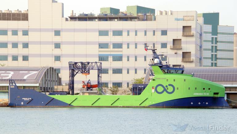
The third image of the selection is purported by the writer to show ‘Armada 7808 is equipped with 2 AUVs, crane and davits designed for search operations‘. That statement is emphatically incorrect: Armada 78 08 is equipped with a Kongsberg built LARS (the green structure over the forward moonpool) that operates two Saab Seaeye Leopard eWROVs. These eROVs operate only to a depth of 3000m therefore unsuitable for 7th arc depths. The Leopard ROVs are parked in the open under the LARS during vessel transits. Armada 78 08 has no AUVs embarked at this time (Thu 6th Feb).
The fourth image of the selection is purported by the writer to show ‘Armada 7806 is equipped with a gantry over a moon pool in the deck and is capable of handling a ROV for wreckage filming, recovery and salvage operations’‘ That statement is emphatically incorrect: the Seaonics LARS rig constructed over the aft moonpool is intended to operate a, yet to be commissioned, geotechnical seafloor survey system. Armada 78 06’s Seaonics LARS is not intended to operate an ROV such as the 4500m-6000m rated Schilling or Kystdesign WROVs which, for example, are deployed on Armada 78 01. Besides, recording of a wreckage/debris field may be undertaken by Hugin AUV camera systems to produce a mosaic of the area.
For the fifth image of the selection the writer describes ‘Armada 7806 had a blue container loaded this morning‘. Indeed it did. That blue container was loaded on Armada 78 08 in Mossel Bay, together with the transportable AUV container hangar, and ferried to Port Louis where the two containers were transferred to Armada 78 06 bringing its complement of AUVs to three in total. The blue container likely provides a supporting/servicing cabin for AUV operations.
Where the MPA ‘Port Situation’ advice states, in relation to Armada 78 08, an activity ‘ld ships spares‘ this implies that Armada 78 08 will remove from Port Louis all parts dismounted from Armada 78 06 when installing the additional containerised AUV hangar and the support/service cabin.
Direct, scheduled, Air Mauritius flights operate weekly from Kuala Lumpur only on Tuesday and Friday. Any Malaysia observer that may be assigned to the search would find the Friday service a timely connection to join Armada 78 06 departure on Saturday.
Should any of the images linked above become unavailable, the selection is archived here
It is not that I want Armada 78 06 to be the vessel that conducts the search, while others appear to be insistent that Armada 78 08 will be the vessel to conduct the search. It is that the observed configuration of Armada 78 06 confirms it is the vessel configured and equipped to conduct the search.
Similarly, it is not that I don’t want some statistical data mining of the WSPR spot archive to discriminate the position of an aircraft, it is that observation of received WSPR signals and experimentation in conditions where RADAR-like characteristics might be reliably discriminated have shown that absolutely nothing can be described as ‘detectable’.
And it is not that I want the flotsam known as ‘tataly-antsiraka’ and ‘broken-O’ to be identified as originating from Vestas Wind, it is that careful and deliberate observations show that those items of flotsam are not landing gear trunnion doors or anything related to a Boeing 777 but they are items that are consistent in construction with decking and the bulkhead separating the steering gear compartment and OBM station/sleeping compartment of the VO65 yacht Vestas Wind grounded on the Cargados Carajos Shoals, November 2014. One particular individual did not want those items examined by the VO65 designer and intervened to stop Farr Design doing so.
@Don Thompson: Once again, thank you for the facts.
Armada 78 08 has updated its AIS with a ETA to match the destination broadcast by the vessel over recent days.
Destination: Cape Town
ETA: 2025-02-18T1900Z
Bunkering and loading of equipment removed from Armada 78 06 (coded as ‘ld ships spares’ in MPA Port Situation information) must be almost complete in preparation for imminent departure.
By a process of elimination only Armada 78 06 remains in Port Louis ready to make the voyage east to the 7th arc search area.
@Victor
Re: 25-hr CVR
Apparently USA’s NTSB 25-CVR proposal was officially adopted…”CVR technology is about to become even more useful thanks to a provision of the Federal Aviation Administration Reauthorization Act of 2024, which was passed by Congress in May. The act requires all commercial aircraft in the U.S. – both new and (surprisingly) existing – to be equipped with 25-hour cockpit recording devices.”
Last January, I had submitted public comment in support of the NTSB proposal based on my experience following the MH370 accident. My comments below:
https://www.regulations.gov/comment/FAA-2023-2270-0094
Here is an informative report on the AA5342 PAT25 midair:
https://bit.ly/413vmLZ
There were several sources of altitude data for PAT25 ranging from 200 feet to 400 feet, noting however that the resolution for some was only 100 feet. The data from the CRJ FDR was more precise: 325±25 feet.
To me, it sounds like PAT25 may have been slightly above the CRJ when the PF the CRJ saw PAT25 and tried to climb to avoid it. That certainly could make sense if you are down at 325 feet.
Looking at the Berth plan for Port Louis, Armada 78 06 is set to Shift to QE tomorrow for Fueling.
@Joseph Coleman
Glad you could make sense of that ‘Port Situation‘ document, its formatting and presentation is appallingly poor!
Yes, bunkering from Vivo Energy followed by departure. Whether departure is to direct to the 7th arc search area or a local test/validation area remains to be seen.
There is a tropical cyclone moving east to west across the ocean but the forecast shows it waning.
@Joseph Coleman,
Actually, Armada 78 06 has just now (Friday, 20:20UTC) completed the move to Quay E.
@Don Thompson
I noticed the movement a little while after I posted. They are 4 hours ahead of us in that neck of the woods. They’re Starting nice and early, no messing about. Go Ocean Infinity Go.
While we wait for 78 06 to make its next move, I am going to provide a link to some work on the radar that I did almost a year ago. Jean Luc Marchand, Capt. Blelly, and a certain trise5631 wrote a document regarding certain data extracted from the Geoscience Australia website that they interpreted as being the primary military primary radar data provided to the ATSB. Most importantly, they were able to reconstruct time stamps for the positional data. I compared this reconstructed track with the civilian ADSB, secondary, and primary radar data in more detail than they had done. Bottom line – the reconstruction looks good and now supersedes some work I had done several years ago.
https://docs.google.com/document/d/1k8KJqb2zGfcA5eiztqMMsvaorldUUan2Lu-dXEVMr54/edit?tab=t.0
@Joseph Coleman
@Don Thompson
As I recall these new ships were said to run on ammonia as fuel?
@TBill
At present, the Armada 78’s generators consume ‘clean’ diesel.
Armada A78 is a lean crewed vessel with facilities to host up to
sixteen marine and payload personnel. It is prepared for future fuels with two large tank spaces, fuel cell rooms and a DNV Ammonia. Ready notation prepared for future upgrade. Checkout Armada 78m specs PDF web link:
https://oceaninfinity.com/wp-content/uploads/2023/08/OI-ARMADA78-Spec-Sheet-2023.pdf
airlandseaman wrote about the PAT25-JIA5342 collision.
Mike makes an important point about the capability of technology to support decision making and post-flight analysis in an area of traffic density operating with such minimal separations. This is separate from the issue of DFDAUs, that may provide recoverable data, and DFDRs.
The ATC monitoring of altitude via secondary surveillance radar or ADS-B relies on an altitude parameter quantised to 100ft or 25ft increments (per Eurocontrol monoradar and ADS-B target report specifications, & likely, the FAA’s equivalents). The eJet’s transponder was transmitting altitude at 25ft increments, the UH-60 at 100ft increments. This is a transponder capability. While the crew has visibility of a radio derived altitude at these altitudes, baro alt is the primary parameter used on the ground (enhanced surveillance options include geo/GNSS derived altitude).
The Baltimore-Washington Helicopter Route Chart states:
DESCRIPTION OF ROUTES AND ALTITUDES
ALL ROUTES MAY BE ALTERED AT PILOT’S REQUEST OR AS DIRECTED BY ATC.
ROUTE ALTITUDES ARE MAXIMUM
Maximum altitude for Route 4 north of the Wilson Bridge, encompassing the site of the collison, is 200ft. However, the controller’s console view of altitude, presented on their screen, cannot accurately discriminate whether a helicopter is clipping boat wakes in the river or broaching the maximum altitude and risking a collision above 200ft. The controller has barely enough information to be a ‘controller‘ or at least an assistant, only lateral position is of adequate resolution to assist. That the UH-60 pilot had been given authority to continue and maintain visual separation isn’t an excuse, it’s a symptom of what the system delivered.
It’s not as if the FAA hasn’t quantified and codified the surveillance systems’ performance, it has. In the Washington-Baltimore area, the fallback has been airmanship and Mk.1 eyeball. I remain to be convinced that’s a satisfactory solution, hence, much misalignment between the cheese slices.
The thought that techbros propose, generally, to introduce unmanned air vehicles as flying cabs into urban airspace is just insane.
@TBill
RE: “The act requires all commercial aircraft in the U.S. – both new and (surprisingly) existing – to be equipped with 25-hour cockpit recording devices.”
The retrofit requirement is surprising, given that neither ICAO nor the European regulator (EASA) adopted such a requirement in their own rules. In 2018, the NTSB recommended the retrofit of CVRs capable of recording the last 25 hours of audio, but the FAA did not adopt that recommendation in its 2023 NPRM on the matter. NTSB lobbying clearly prevailed!
The FAA isn’t required to issue a final rule on the retrofit requirement until 16 May 2027. It will be interesting to see if the requirement survives or is ultimately dropped to harmonise US regulations with the ICAO standards and the regulations adopted by EASA.
@Andrew
If CVR25 retrofit stands, does it mean only U.S. aircraft or does it apply globally? In any case my message is, those living outside USA may want to move forward on recommending retrofit for their specific countries, where it makes sense (for those aircraft where it is feasible to make/schedule the switch).
@sk999
I am very interested having just downloaded your digitized for the purpose of putting it on a SkyVector flight path. The first thing I notice, looking at the IGARI turn back, the former digitized path drops as low as approx 200 kts which it suggestive of steep climb during turn, whereas the MTB shows more constant speed. For my purpose I do not really need the accuracy, but will you update your digitized path?
@TBill
The retrofit requirement would apply to US-registered aircraft. I think it would also apply to foreign-registered aircraft operated by US carriers under a dry-lease arrangement, for example.
Re: MH370
Armada 78-06 departed Port Louis at 2025-02-08 17:41Z and at 1929Z was 20NM north of Mauritius heading 095°T at 2KTS. The AIS is indicating “Offshore Mauritius”, but I suspect the SE trade winds are freshening and the easterly swell is rising as tropical cyclone “Vince” with central pressure of abt. 946hPa at 1800Z was at 20° 30’S 071° 12’E moving in WSW direction at abt. 10KTS with winds of up to 215KTS. TC Vince is expected to start turning slowly to a southerly track over the next 12 hours.
If Armada 78-06 is bound for the MH370 LEP, I suspect that progress is going to be slow over the next 48 hours.
Update;
Armada 78-06 appears to be undertaking trials of gear, and has recently launched a boat (fitted with AIS) that is operating close by, i.e. <500 meters.
An animated chart of meteorological conditions including predicted TC track(s) is at:-
https://zoom.earth/maps/pressure/#view=-20.61,70.992,6z/model=gfs/overlays=wind
@Barry Carlson,
I expect that Armada 78-06 is undertaking trials with the third AUV that has been mobilised in Port Louis. At present it’s operating over reasonably shallow water, circa 500m depth, on the Mascarene Plateau so depth testing AUVs isn’t the objective (they’re not fresh out of Kongsberg, Horten).
AUV launch requires the vessel to guide the AUV via acoustic comms and positioning to a final GNSS referenced INS alignment when the DVL establishes with the seafloor. The vessel’s indicated speed is consistent with that activity.
This time around, AUV operations will be coordinated between the vessel and the RCC in Woolston. To the best of my knowledge, and that is only by observation over recent months, this is the first time that an Armada 78 has operated three AUVs. A78-07 and A78-05 have both operated with a single AUV, A78-06 previously with two.
It’s been reported to me that a small craft has been observed close to A78-06, possibly the fast recovery boat that you and I have discussed off-line.
As yet, there is no confirmation of the inception of a contract with Malaysia. That ‘milestone’ may be hastened with a demonstration of AUV operating trials by Armada 78 06.
@Barry,
Ah-ha, you’ve also noticed the small craft. Extended time drafting my comment while you posted a second + third.
That small craft is configured on each Armada 78 that has operated AUVs (-05, -06, and -07). It’s used in recovery of the AUV back to the hangar’s stinger. Another reason Armada 78-08 was never the ‘assigned’ vessel for the search.
TBill,
That drop in speed was was an artifact of the DSTG’s modeling of the turnback (which I never understood). I just used the MTB version of the data (with time stamps) directly, and while my speed determinations are more sensible, there is still has a gap at the turnback that is not modeled correctly. So the MTB version of the data is the update, even if it may not be what you want.
@Don Thompson,
Thanks Don for the update. Currently, at 08T0100Z I have the 78-06 heading 261°T at 1.7 knots – not far from the earlier position. The small boat hasn’t updated on Marine Traffic and it may be back onboard.
NB. My previous mention of the max windspeed of TC Vince gave the speed in Knots, when it should have been 215 km/h. A significant difference!
Apologies for the miscellaneous ‘°’ in my previous post.
@Barry Carlson. For interest, wave height, top section of:
https://www.surf-forecast.com/weather_maps/Indian-Ocean?hr=3&over=none&type=htsgw
Set to IST, UTC + 5½. Next 12 days projected.
Also wind guide, though getting east the below is more detailed:
https://www.surf-forecast.com/weather_maps/Western-Australia?hr=3&over=pressure_arrows&type=wind
The 3rd selection, wind energy, is new to me.
@Barry. Last line, ‘wave’ vice ‘wind’.
@Barry Carlson,
After reviewing the Zoom Earth and earth.nullschool.net weather forecasts can I ask if you consider it feasible that Armada 78 06 could reliably navigate a way through the remnants of these two tropical cyclones?
Assuming the trials activity concludes satisfactorily it may be Monday Feb 12th before the vessel departs waters around Mauritius and a further five-six days before crossing east of the E70º line of longitude where TC Vince is expected to be moving southward.
More generally: the satisfactory conclusion of the trials activity would be a milestone indicating the vessel and equipment’s readiness to proceed to the 7th arc search site. That’s likely a good time for an exchange of signatures.
One might think the combined minds of a lawyer, an ‘editor’, and a project manager would be sufficiently aware of how business is conducted to comprehend that a publicly voiced, tacit, MoU would progress to paper and signatures when the parties have completed preparations and are ready to deliver.
@Don Thompson: The fact that Armada 78-06 is conducting sea trials is a positive development. Despite the reported drama, it looks like OI and Malaysia are closer to a signed agreement for the search. The signing of the agreement just before the search is exactly what occurred last time.
@Don Thompson,
Re – “… can I ask if you consider it feasible that Armada 78 06 could reliably navigate a way through the remnants of these two tropical cyclones?”
Tropical Cyclones are at their most dangerous when tracking to the West, but on curvature i.e. turning to the South (S. Hemisphere) their intensity will slowly decrease and after reaching 25°S they are treated as an ex sub-tropical Low and will blend into the middle latitude pressure systems tracking Eastwards. Due to their relatively small physical size, the effect they have on the sea surrounding them is limited, though within 60NM of the TC centre, sea states can be high and confused.
On passage from Mauritius to the MH370 LEP, the wind will be normally from the SE with a mean wind speed of 13 knots, less at night and up to 20 knots during the heat of the day. For vessels of the Armada class, a comfortable speed will in these conditions will probably be in the 8 to 10 knots region.
Maybe Armada 7806 should consider leaving Mauritian waters soon & head due east for ~7 days (~1500nm @ 9kts) to avoid rough weather & forecast movements of Cyclone Vince & Cyclone Taliah then they could head safely southwest towards #MH370 search areas…
https://www.windy.com/?-22.147,83.936,4,i:pressure
In certain quarters, there appears to be some furore building that Armada 78 06 has yet to complete trials and begin its passage to the 7th arc search area, that Malaysia hasn’t yet concluded the agreement for OI to search, and that time is running out.
A reminder that Fugro brought in two AUV equipped vessels to support their search operation. Both these vessels operated Fugro’s Hugin 4500 AUV.
Fugro Supporter in ‘Field’: 2015-01-04 thru 2015-05-17, final AUV working day 2015-05-11.
Havila Harmony in ‘Field’: 2015-11-23 thru 2016-03-26, final AUV working day 2016-03-20.
The Armada 78 06 is still engaged in underwater operations and at Feb 13, 2025 0011 UTC was located at 19° 38.2’S 057° 32.6’E Hdg 123°T @ 2.8 KTS.
Further examination of positions attributed to the vessel have revealed that the AIS terrestial positions were being received intermittently in Port Louis, and the odd satellite position received was not from her boat, but were actually those of the 78 06.
During the last 4 days the vessel has moved in a small area of about +/- 2.5NM, but for the majority of the time has been stationary (dynamic positioning system) on a heading that possibly represents the prevailing wind direction.
I’ve sourced part of a British Admiralty chart of the immediate area showing the depths/heights in feet.
https://ngamotu.nz/images/armada78-06.png
Unfortunately, there is no latitude reference scale, but if required, there are 2 lines of longitude shown – 30 mins apart at 057° 30’E and 058° 00’E;. So reference any distance you measure to the longitude and divide it by the Secant of the latitude – (19.5° = 1.0618) will give a result in Nautical Miles.
@Barry, all
While there is no detailed MBES bathymetry or DEM for the specific area where Armada 78 06 is operating, a mosaic depicting an MBES survey line running E-W approximately 10km south of A78-06’s position is publicly available.
It may not be relevant but escarpments to the east and west of the vessel’s position run down to depths of 4000m.
Sorry for drawing attention back to this, but you guys probably saw this report:
https://www.nytimes.com/2025/02/13/business/dc-plane-crash-control-tower-reagan.html
Wasn’t a very comfortable conversation with the Times blaming your own ilk, but absolutely needed to get it out there. Some points I made:
1) FAA screwed up, but this isn’t news. Happens (and will happen) when you lack precise accountability
2) The lack of urgent and clear 3-way communication by the Control Tower is ultimately the reason for this specific disaster. “CRJ” and “pass behind” simply is not acceptable language, especially at night
3) Controller short staffing, lack of training, Helo non-compliance, night-vision equipment related hindrance, etc. are all potential contributing factors, which the NTSB will dive into
Thought they did a good job summarizing. FYI, I was told that “real changes” will happen this time (one of the Times reporters on this piece has strong creds). I told her not to hold her breath.
Best,
Adi
@Don Thompson, and All;
Thanks Don. “It may not be relevant but escarpments to the east and west of the vessel’s position run down to depths of 4000m”, made me look again at the Chart, and as I should had noted, the depths/heights are in metres, i.e. not feet.
At 20250213T2005 UTC, the Armada 78 06 was at 19° 38.0’S 057° 35.7’E and stationary.
@Barry Carlson and ALL
At 20250214T0030 Armada 78 06 is established on a track ESE of the trials area at 9kts.
Following up on Don above. Armada 7806 is heading ESE at 9 knots with its Destination set to OFFSHORE AUSTRALIA and ETA set to Feb 23rd.
https://i.imgur.com/7832b0u.jpg
That’s great news that Armada 78-06 is headed to the search area along the 7th arc. I’m hoping that OI was able to conduct some sea trials along steep slopes that would give them confidence in scanning the steep slopes near the LEP that were previously missed. The steep slope to the south that I designated as a high priority area around (-34.53,93.84) has a grade of 30%.
https://mh370.radiantphysics.com/2023/02/11/a-high-priority-area-to-search-for-mh370/
Despite the good news, I see the drama continues to be propagated by some.
@Adi,
Thanks for sharing that article. I hope they quickly make some changes.
@All,
The GC track from the 20250214T0030Z position is 123°T, with an arrival heading of 106°T at the LEP. Could be heading for the Southern end of the expected search area. Around 2100NM to go.
Good job with the original article from 1/28, it has turned out to be very accurate so far.
@eukaryote: Thanks. Don’s assessment of the vessels was correct. My comment at the bottom of the post was just common sense. Sometimes people create drama when there is none to get attention.
@All,
Armada 78 06 is still tracking 140°T at 9.4KTS, and at 14T1910Z was at 21° 58’S 59° 54’E. Wind is 095°/18KTS.
From my perspective, it appears that a decision was made to get south of the Tropical Cyclone that is slowly filling as it approaches a High developing to its South, and then take a more Easterly track towards the LEP.
@All,
Armada 78 06 at 12/T0812Z was at 23°18’S 061°09’E Hdg 139°T at 8KTS. Wind 083°T/15KTS, and combined sea & swell Ht of 2.8m.
Check https://zoom.earth/storms/taliah-2025/#map=pressure/model=icon for information on TC “Taliah”. Click on the TC center icon to bring up a description of past and forecast tracks. There is a Latest Warnings button at the bottom of that description; click for detailed forecast over the next 4 to 5 days.
@All,
Previous post had time typo; should have been 15/T0812Z.
Update: Armada 78 06 at 15/T1954Z was at 24°29’S 062°17’E Hdg 138°T at 8.4KTS. Wind 110°T/14KTS, and a combined sea & swell Ht of 2.8m.
@Victor Iannello
Victor, regarding the drama being propagated from just one particular quarter, creating drama, spreading misinformation, creating disinformation, and sowing division are their stock-in-trade. They have nothing material to offer, so they lean into generating controversy for self-promotion.
Despite claiming that their “sources in Malaysia are impeccable”, they have been demonstrably wrong on every material aspect of the search so far. And, of course, now they are in damage control, rewriting and deleting posts, trying to cover their tracks (thank you, web.archive.org). They’re shameless.
@All,
Update: Armada 78 06 at 16/T0801Z was at 25°43’S 063°31’E Hdg 138°T at 8.1KTS. Wind 115°T/12KTS, with a combined sea & swell Ht of 2.3m.
@All,
Armada 78 06 has altered course to avoid the still active TC “Taliah”.
At 16T1352Z in position 26°20’S 064°06’E, course was altered to 090°T, which will allow the vessel to pass North of “Taliah”, now down graded to a Tropical Storm.
Update: Armada 78 06 at 16/T1929Z was at 26°20’S 065°03’E Hdg 091°T at 9.0KTS. Wind 125°T/15KTS, with a combined sea & swell Ht of 2.5m.
Question. Notwithstanding the apparent jig to the east today to route around the storm…if you were headed towards 34S, why would you spend the first several days pointing towards 40S?
@Don Thompson. Depending on search success and when, disturbance of wreckage
might be needed when seeking early recovery of such as the recorders at least.
If so, how?
You note that 7808’s forward moonpool LARS is for Saab Seaeye Leopard ROV deployment, though limited to 3000m max depth.
However as also you point out 7806 instead has a gantry type LARS above the rear moonpool.
That might be for the other two ROVs listed in the 78m series specs, these being the larger Saab eWROV and Schilling HD WROV. Both have a 5000m option.
https://www.saab.com/products/ewrov
https://www.technipfmc.com/media/f45niiua/data-sheet-schilling-hd.pdf
I have found no detail on the different ROV capabilitites that lead to OI needing a selection of three. 7808 is the last of these vessels yet is fitted with the smallest.
That aside, 7806 might have one that could dive to 5000m.
In any event a larger vessel might be needed to accommodate those people that might need to be on hand to receive whatever is recovered, and for deck space then or later, than a 78 or two might offer.
Can you throw any light on this?
PS to add to the ROV configuration puzzle I see that 7805 was fitted with two gantries.
https://www.linkedin.com/posts/ocean-infinity-llc_oceaninfinity-marinerobotics-armada-activity-7122537759885471744-S3ZC?utm_source=share&utm_medium=member_desktop
@paul smithson,
Re: “……if you were headed towards 34S, why would you spend the first several days pointing towards 40S?”
I can only speculate that the information available at the time the vessel commenced its passage toward the LEP, was that TC “Taliah’s” progress would slow and turn to the South earlier and lose its intensity. If that was the case, then it was a reasonable plan to avoid the TC by heading 140°T to 34°30’S and parallel sail on a course of 090°T to intersect the 7th Arc.
@All,
Armada 78 06 has maintained a track of 090°T throughout their night. Sunset took place at 16T1415Z, shortly after the vessel changed course to the East at 16T1352Z. Sunrise would have been about 17T1425Z.
Update: Armada 78 06 at 17/T0758Z was at 26°21’S 067°06’E Hdg 088°T at 8.5KTS. Wind 100°T/10KTS, with a combined sea & swell Ht of 1.5m.
@All,
The time of sunrise mentioned in above post, should have be 17T0225Z.
@All
Please see through the link an update for my ongoing analysis of BTO/BFO data.
The latest results seem to indicate that the southern half of the S33 – S36 latitude range would be most relevant, and that the “PLEIADES” hypothesis deserves serious attention.
https://www.dropbox.com/scl/fi/h80n0w2izks48v730hiex/update_17_02_2025_v8.pdf?rlkey=0buc8nwhlb374eboirhlt4jb1&st=fmx63fjo&dl=0
@All,
Armada 78 06 has maintained a track of 090°T during the day, with Sunset at 17T1420Z.
Update: Armada 78 06 at 17/T1923Z was at 26°21’S 068°51’E Hdg 093°T at 8.5KTS. Wind 170°T/10KTS, with a combined sea & swell Ht of 3.4m.
Between 17/T0758Z and 17/T1923 the distance made was 94NM, giving an average speed of only 8.1KTS. About 4 hours prior to this update the vessel was noted as heading 149°T at 3.1KTS with the combined sea & swell from the SSE at 5m. Possibly something needed to be resecured on deck.
@David, you posed a number of questions above. So, some light:
Ocean Infinity has published, at their website, an Armada A78 Specifications brief setting out the fleet’s capabilities. This brief was created in August, 2023, a time when not all vessels had entered the water at Vard, Vung Tau.
I have noted this brief has been construed, in other quarters, as an ‘a la carte’ menu of capablities that may be called off for any particular vessel. In reality, A78 fleet comprises four mobilised configurations:
A78-01: mobilised with a single Seaonics tower to operate hydraulic powered wROVs. Initially, A78-01 operated two wROVs but in Sept 2024 the Seaonics tower was re-configured to operate only one ROV.
A78-02, -07, and -08: each vessel configured to operate two electrically powered Saab Seaeye Leopard wROVs using a Kongsberg designed and built LARS situated over the forward moonpool. These ROVs are rated only to 3000m depth. In mid-2024, A78-07 conducted work in the Pacific Ocean operating a single AUV from the type of containerised hangar as pictured in this post’s leading image.
A78-03, -04, and -05: mobilised with two Seaonics towers specifically for geotechnical survey operations. The forward tower is the LARS for OI’s CPT-250 machine, the aft tower for a sonic corer machine. A78-05 has been observed operating a single AUV from the type of containerised hangar as pictured in this post’s leading image.
A78-06: mobilised with a single Seaonics tower. While the intended, design, payload is yet to be deployed on A78-06 it is possible this payload might be a seabed drill machine that is in development.
A78-06 departed Port Louis carrying three AUVs. A number of factors suggest to me that no ROV is embarked for A78-06’s present deployment: its Seaonics tower is a similar height to that required for the corer machine, definitely taller than that on A78-01 to operate wROVs; the cursor has remained at the tower’s topmost position; neither a ROV nor TMS is evident recent images of A78-06; question of umbilical cable capacity in the Seaonic’s winch gear; and, finally, an ROV is not required for a search, only recovery. Certainly A78-06 now has little space available deck space even if it was capable of operating an ROV to the required depths.
The final, successful, AF447 search phase involved the MV Alucia operating multiple AUVs. When imagery acquired by an AUV revealed a possible debris field, an AUV was tasked to ‘fly’ a futher mission over the target area while operating its SSS at higher resolution and acquiring digital still images. A short time later, a vessel capable of operating an ROV and accommodating recovered items was brought on scene.
In the case of a subsequent recovery operation to this search, OI’s Island Pride with two 5500m/6000m operable wROVs and similarly capable lifting gear is well suited to a deep ocean recovery task.
@Don Thompson. Thanks for that comprehensive background and for your conclusion as to how recovery might be realised.
.
That would be quite separate
This aspect might be where the contract for this search might differ substantially from that of the earlier OI search.
I doubt the number of AUV’s deployed would make much difference or active search to periodic transit (to Fremantle presumably) time ratios, except perhaps to the allowed total search time, if specified.
@Barry C. I expect you are correct re changed projected cyclone track and avoidance strategy. I’m assuming that the destination is the zone that OI discussed with MY corresponding with UGIB etc.
@Paul S.
Your assumption is correct if you follow my parallel sailing at 34°30’S to intersect the 7th Arc.
@Barry Carlson. Might go to Fremantle first?
@David,
Someone knows, but count me out. The wind will be dying as they move North of ex TC “Taliah”, and will then come away from ENE before becoming ESE as they enter the High pressure ridge. Their next move should give an indication of intent, though I suspect they will head toward the LEP.
The AIS destination shows – Offshore Australia.
Fremantle Ports expected shipping movements should eventually show any future visits planned for Armada 7806
https://www3.fremantleports.com.au/vtmis/dashb.ashx?db=fmp.public&btn=ExpectedMovements
@Barry. “The AIS destination shows – Offshore Australia.”
Forgot that.
@All,
Update: Armada 78 06 at 17/T0723Z was at 26°21’S 070°59’E Hdg 084°T at 10KTS. Wind 180°T/10KTS, with a combined sea & swell Ht of 3.5m.
At 0600Z the vessel was noted Hdg 125°T at 4KTS, and I suspect that due to the moderate to heavy rolling in the swells, a further inspection of deck cargo lashings etc. was being undertaken.
Another plane crash (Feb 17) in North America, but this time everyone survived.
Delta Flight 4819, a Bombardier CRJ900, from Minneapolis to Toronto Pearson, crashed upon landing and flipped upside down.
Engines burst into flames, but all 80 passengers and crew survived.
There’s a video of the plane landing and bursting into flames.
https://www.cbc.ca/news/canada/toronto/what-we-know-so-far-pearson-airport-plane-crash-1.7461520
@All,
Armada 78 08 at 18/1127Z in position 26°20’S 071°40’E altered course to 114°T. That course intersects 34°52’S 093°50’E, the LEP. Distance to the LEP is 1256NM, with an ETA at 10KTS of 23/1700Z.
Update: Armada 78 06 at 18/T1915Z was at 265°53’S 072°02’E Hdg 112°T at 10.KTS. Wind 190°T/15KTS, with a combined sea & swell Ht of 3.3m.
@All,
Less haste! The Update should have been:-
Armada 78 06 at 18/T1915Z was at 26°53’S 072°02’E Hdg 112°T at 10.KTS. Wind 190°T/15KTS, with a combined sea & swell Ht of 3.3m.
While making the above correction an new position was received:-
18/T1915Z was at 26°55’S 073°10’E Hdg 114°T at 10.4KTS. Wind 200°T/12KTS, with a combined sea & swell Ht of 3.3m.
Correction! 18/T1958Z
@all,
Armada 78 06 at 19T0201Z 27°20’S 074°17E altered course to what appears to be 120°T.
Update: 19T0815Z 27°56’S 075°24’E Hdg 123°T at 11.4Kts. Wind 290°T/12KTS.
This changed track will give an intercept with the 7th Arc further South of the LEP. Will wait another 12 hours before determining where that could be.
Happy new year every body.I am Chinese.
I want to know according to the latest trend of Armada 78 06 or others,did you confirm that the new search will begin rencenty?
And by the way,what’s your opinion about the mu5735?
What is the likelihood of pilot suicide?
@Cui Shineng: It looks like Armada 78-06 is headed towards the 7th arc in the vicinity of where OI previously said it would search next. That means the search is likely to begin soon.
I don’t have any special insights regarding China Eastern Airlines Flight 5735. There appears to be no mechanical issues, and flight controls were reportedly manually manipulated to enter a steep descent. That certainly looks like either pilot suicide or somebody entered the cockpit and took control. Unfortunately, China has not been very forthcoming with information.
@Victor Iannello: Thanks.Really looking forward to.
@all,
Update: Armada 78 06 at 19T1955 29°03’S 077°28’E Hdg 125°T/10.6KTS Wind 035°T/20KTS. Combined sea & swell Ht 2.7m.
In the past 17H54M the vessel has made 198NM at Av. Spd of 11.06KTS, with CMG of 121.3°T.
@Barry Carlson: Thanks, Barry. To avoid confusion, can you please give both the heading and course?
@Victor,
The Hdg and Spd are the actual AIS at time of capture by the Satellite. The actual Course set can only be assumed as per the CMG over a period of time, as given in my last post. The calculation is done using the Mercator method, unless I believe it to be Great Circle; in which case I will state that.
In future I’ll back-check the track for any obvious course change and give the Spd and CMG for that period.
This developing system should weaken before approaching MH370 search area but may create some rougher conditions:
Tropical low (21U) developing to the northwest of the Kimberley and to remain well off the WA coast.
Tropical low (21U) is expected to continue moving westwards into the weekend, while remaining well to the north of the Pilbara coast.
The risk of 21U developing into a tropical cyclone increases to Moderate on Friday and High on the weekend.
21U does not pose a direct threat to Western Australian mainland or island communities.
During next week, 21U is expected to curve towards the south and the southeast, while remaining well off the Western Australian coast.
http://www.bom.gov.au/cyclone/7dayforecast/
@Barry: Since we are using the reported track to project the destination, I just wanted to make sure we are all using terms in the same way:
Course Made Good (CMG): The course over some interval of time
Course Over Ground (COG): The instantaneous track as measured by the GPS device.
Heading: The instantaneous direction that the bow is pointing.
To make things more complicated, some GPS devices report COG as “GPS Heading”.
So again, when you report heading, which do you mean?
@Victor,
The Great Circle initial Course from the 20T0020Z position mentioned in my last update, to the intersection of the search area SW border and the 7th Arc is 120°T, Dist 797NM.
So, appears they are using a GC track. Difficult to see when vessel is yawing as it handles the wind and sea conditions, and any surface current.
@all,
Update: Armada 78 06 at 20T0755 30°09.5’S 079°35.7’E Hdg 119°T/11KTS Wind 050°T/19KTS. Combined sea & swell Ht 2.5m.
In the past 07H35M the vessel has made 83.1NM at Av. Spd of 10.96KTS, with CMG of 121.1°T.
@Victor,
I am using –
CMG (Course Made Good) i.e. Point to Point over period of time. The point to point calculation is by Mercator method.
Hdg (Heading) Vessels Heading reported by AIS at the position time.
@ All, @Barry Carlson
Thanks Barry for your contribution 🙂
Today, thanks to Mr. Trise, we have designed a dedicated webpage to follow OI Armada 78-06 ship’s progress.
The page is available here:
https://www.mh370-caption.net/index.php/armada-tracking/
The ship’s progress is updated at 30 minutes past every hour with a time difference of 1h30. The search and searched zones are also illustrated.
This will work as long as the AIS is available !
@JL-M,
‘ with a time difference of 1h30’
Time difference from what?
@Don, in light of the smaller number of AUV’s do you anticipate slower rate of search than the “up to 1300sq.km. per day” in 2018? Does the new kit cover a wider swathe per pass? I realise that there is the additional question of difficult terrain and discontinuities between areas of interest.
@all,
Update: Armada 78 06 at 20T1950 29°03’S 077°28’E Hdg 116.8°T/9.1KTS Wind 040°T/18KTS. Combined sea & swell Ht 2.5m.
In the past 11H55M the vessel has made 118.5NM at Av. Spd of 9.94KTS and CMG of 120.3°T
NB; Here is some examples of the vessel’s so-called instantaneous Course & Speed as presented by the AIS.
(a) 20T1536Z 118.7° 9.5KTS
(b) 20T1630Z 122.1° 10.0KTS
(c) 20T1721Z 121.1° 9.0KTS
(d) 20T1814Z 118.9° 9.1KTS
(e) 20T1816Z 118.8° 9.0KTS
(f) 20T1855Z 119.1° 8.8KTS
(g) 20T1900Z 118.2° 8.9KTS
(h) 20T1943Z 117.8° 9.4KTS
Hopefully, that explains why I describe the so-called Course as the Heading.
@All,
Too busy to other stuff!
The above 20T1950Z position should be 30°09.5’S 079°35.7’E
Everything else should be OK.
A Copy & Paste disaster!
@Paul Smithson asked ‘in light of the smaller number of AUV’s do you anticipate slower rate of search than the “up to 1300sq.km. per day” in 2018?‘
Paul – yes, that’s inevitable. To the best of my knowledge, the Hugin 6000 AUVs remain equipped with the same Edgetech 2205 side scan sonar (not the Kongsberg HiSAS system). There are no magic bullets to improve the performance of the SSS.
However, a significantly improved AUV endurance can be expected, and it’s understood that the AUV recovery process onto the host vessel is now more effective.
@Don Thompson,
90 minutes behind real time at time of update.
@Jean-Luc et Mr Trise,
Merci.
@victor I remember at the time of the last search you were fairly confident of success (67% was the probability you gave if i recall correctly).
out of interest – how confident are you thia time around?
thanks.
Virtually on course for 36S
@Don Thompson “…a significantly improved AUV endurance can be expected, and it’s understood that the AUV recovery process onto the host vessel is now more effective.”
That’s great news, thank you for the continued insight.
@all,
As the last update at 20T1950 had the a completely incorrect position, I’ve added a position for 20T2000Z, i.e.
20T2000Z 31°10.0’S 081°35.7’E – which will be used for for calculating the CMG to the following:-
Update: Armada 78 06 at 21T0003 31°29.4’S 082°14.2E Hdg 121.7°T at 9.5KTS Wind 045°T/15KTS. Combined sea & swell Ht 2.3m.
In the past 4H03M the vessel has made 38.3NM at Av. Spd of 9.45KTS and CMG of 120.4°T
@George G
I agree that the present rhumb line track intersects the 7th Arc at 36°S. However, in the current sea/swell conditions, the vessels intended destination can only loosely be presumed based on the current CMG.
Spoiler: They’ve already shown a propensity to head to a Latitude then make an Easting by parallel sailing.
@Barry Carlson,
Agree. Just simple observation concerning current track. No more.
@all,
Update: Armada 78 06 at 21T0403Z 31°48.4’S 082°51.7’E, Hdg 119.1°T at 9.0KTS, Wind 040°T/17KTS. Combined sea & swell Ht 2.3m.
In the past 4H00M the vessel has made 37.1NM at Av. Spd of 9.28KTS and CMG of 120.1°T
@VictorI
A new Task Force on the Declassification of Federal Secrets has been appointed by the US House Committee on Oversight and Government Reform.
It seeks “briefings by February 18 on documents in their possession pertaining to the assassinations of President John F. Kennedy, Senator Robert F. Kennedy, and the Reverend Dr. Martin Luther King, Jr; COVID-19 origins; unidentified anomalous phenomena (UAP) and unidentified submerged objects (USOs); 9/11; and the Epstein client list.”
Do you think it’s time to submit a new FOIA request to the FBI on their dossier on MH370?
@all,
Update: Armada 78 06 at 21T0804Z 32°06.6’S 083°29.4’E Hdg 118.4°T at 9.1KTS. Wind 040°T/17KTS. Combined sea & swell Ht 2.3m.
In the past 4H01M the vessel has made 37.14NM at Av. Spd of 9.25KTS and CMG of 120.06°T
@vodkaferret: Good question. If OI searches no more than 15,000 km2, I would say less than 50%. Finding the debris field will require some luck.
@CanisMR: I’ll submit another request after things are a bit more settled at the FBI. The new director was only confirmed yesterday.
@victor thanks for replying. A sorely missed commentator from the past would have seen it differently. I hope you’re right, close to 50% is worth a shot.
And indeed, logic would say the more time passes the harder the debris field will be to identify, even if one is looking in exactly the right spot.
@Victor @CMR
I was also planning to attempt FOIA request
@all,
Update: Armada 78 06 at 21T1945Z 33°02.9’S 85°23.8’E Hdg 116.6°T at 9.6KTS Wind 010°T/15KTS. Sea 2.1m.
From 21T0804Z to 21T1945Z- 11H41M, the vessel made 112.03NM at Av. Spd of 9.59KTS. CMG = 120.2°T.
@JL-M et M. Trise,
Some lat-long coordinate references on the map would be very helpful. Perhaps stating the corners of the purported target triangle and/or have the user’s browser pointer translate to an arrow ↖️ with a corresponding lat-lon reference.
@all,
Update: Armada 78 06 at 22T0006Z 33°22.3’S 86°04.3’E Hdg 129.9°T at 9.2KTS Wind 015°/18KTS. Sea 2.1m.
From 21T1945Z to 22T0006Z – 4H21M, the vessel made 39.18NM at Av. Spd of 9.01KTS. CMG = 119.68°T.
@all,
Update: Armada 78 06 at 22T0805Z 33°45.8’S 87°17.2’E Hdg 100.8°T at 9.6KTS Wind 350°/18KTS. Sea 2.1m.
There will not be a CMG with this post, as at 22T0116Z in 33°27.7’S 086°15.4’E the vessel abruptly turned South and started a meandering course which ended at 22T0331Z at 33°38.7’S 086°26.9’E when the vessel adopted a new course of about 101°T.
The new track, if maintained will lead into the proposed search area – close to the LEP.
I’ll post a link to an image of the meanderings in my next update after 2000Z.
@Barry, all
Between 22T0115Z and 22T0325Z, A78-06 made a deviation from steady track towards the search areas then re-established a CMG of 100º.
There are a number of Chinese fishing vessels in the area that are tending drifting long lines, ‘long‘ being possibly 10s of kilometres long.
@Don Thompson: It appears that Armada 78-06 is headed towards the steep slope south of the LEP that I designate as a High Priority Search Area. This area was previously missed by both Seabed Constructor (OI) and GO Phoenix (ATSB) due to the challenging terrain.
@all,
Update: Armada 78 06 at 22T2016Z 34°08.1’S 89°37.5’E Hdg 101.2°T at 9.6KTS Wind 325°/16KTS. Sea 2.5m.
From 22T0805Z to 22T2016Z – 1211M, the vessel made 119.03NM at Av. Spd of 9.76KTS. CMG = 100.8°T.
On current course, the vessel’s track will intersect the 7th Arc on the SW boundary of the search area, with 128NM to run.
@all,
Update: Armada 78 06 at 23T0404Z 34°23.9’S 89°37.5’E Hdg 101.2°T at 9.6KTS Wind 325°/16KTS. Sea 2.5m.
From 22T2016Z to 230404Z – 7H48M, the vessel made 73.53NM at Av. Spd of 9.43KTS. CMG = 102.4°T.
Vessel is moving in a confused sea and swell. A cold front of a Southern Ocean Low, to which the remnants of ex TC “Taliah” have attached is moving East about 60NM to the SW.
I am following the path and wondering whether they will turn north or south after starting their search. My hunch is south but I am not confident.
We now have a stationary Armada 78 06 over the steep gradients/canyon at S34.6º E93.6º.
Perhaps sooner, but I’d expect by 8am local time Kuala Lumpur the first of A78-06’s three AUVs will be making the descent to the seafloor.
8am being doors open time to the corridors of Putrajaya, the Malaysian federal capital.
Here is the location of Armada 7806 on a map showing the High Priority Search Area. The ship is positioned near the part of the slope that has not been searched, although it remains in an area already searched by GO Phoenix.
https://x.com/RadiantPhysics/status/1893753730194948577
As Don implies, perhaps the ship will remain stopped in this area until a contract is in hand. If they decide to search without a contract, my guess is AIS updates will stop.
@all,
As reported earlier by @Don Thompson, the vessel has arrived at the presumed position for the commencement of the AUV survey. The weather is rather marginal, i.e. the front has passed through and the wind has backed to 220°T/14KTS. Unfortuneately, the major swell is also from that direction and the sea state height is 3.1m.
Update: Armada 78 06 at 23T2022Z 34°37.2’S 093°40.1’E Hdg 028°T at 0.2KTS.
Yes, Armada 78-06 stopped closed to the IG spot. Let’s see what’s next 🙂 This is a good news: they are close to start searching !
We are constantly improving the page
https://www.mh370-caption.net/index.php/armada-tracking/
The ship’s progress is updated as already explained, the search and searched zones are also illustrated and they include hot spots (to be completed) with descriptive tags. The pointer coordinates are given on the top right corner.
@Jean-Luc,
🙂
This graphic shows the path of Armada 7806 in relation to areas of ambiguous or missing data, the GO Phoenix search area, the previous OI search area, and the new search area that was proposed in March 2024. Clearly, filling in the previous data close to the 7th arc is a high priority. I agree with this approach.
https://x.com/RadiantPhysics/status/1894074223733162111
@all,
Can anyone give a rough estimate of how many hours it could take one AUV to scan HPSA steep terrain as it looks like Armada 7806 has departed that area?
@Ben John,
At 0830UTC, Armada 7806 was approximately 20km west of the High Priority Area. It has been crossing the 7th arc back and forth deploying AUVs and recovering them.
I believe the battery on these AUVs can last up to 48 hours?
@Ben John,
The AUV’s speed along track is approx 3.5kmh, its side scan swath is approx 900m each side so 3.5×1.8×24 gives a rough basis for rate of coverage in km² per 24hrs. However, challenging terrain isn’t likely to be covered in regularly spaced track lines. The first AUV sortie along the steep grades of the HPSA covered approx 37km before recovery at 24T1740Z. I give approximations as the precise AUV time on the seafloor can only be estimated from Armada 78 06’s movements.
@Godfrey Jack,
AUV battery endurance is not a factor during these initial operations. The AUVs are revisiting limited areas assigned with low probabilty of detection after the 2014-2017 campaign by Fugro and ‘team Phoenix’ as noted by Victor, above.
The stock Kongsberg batteries for the Hugin provided approx 48hrs endurance. If it’s assumed the three Hugin’s operating from Armada 78 06 are equipped with Kraken’s improved batteries the endurance will be approx 100hrs.
The Malaysians have finally acknowledged that Ocean Infinity’s new search has commenced, albeit without a signed contract at this point. Some reports say they now have clearance from the Attorney General, but there are still some changes required to the terms and conditions:
The Star: Renewed search for MH370 begins, confirms Anthony Loke,, 25 Feb 2025
Malay Mail: Loke: Ocean Infinity’s search for MH370 has Transport Ministry’s full backing, 25 Feb 2025
Bernama: MOT Backs Ocean Infinity’s Renewed MH370 Search – Loke, 25 Feb 2025
@Don re AUV max coverage rate. If they had 7 (?right) AUVs running in 2018 and max coverage/day of 1300sq.km that gives you 185 sq.km max per AUV per day. So about 20% higher than your estimate above – ideal conditons permitting.
@all,
So one AUV could have finished scanning at least 30.5 km2 of steep terrain never scanned in High Priority Search Area (HPSA) after 48hrs? Could Ocean Infinity already be analysing data from HPSA on board and/or in one of their remote control centres?
https://oceaninfinity.com/ourtechnology/
@Paul Smithson,
@Don Thompson,
I presume Don has better information, but until he replies, I seem to remember that the AUVs were previously considered to cover up to 2 km in one sweep due to the two side scanners and the multi beam device covering in between where the side scanners could not.
Then there was an overlap in sweeps to ensure coverage.
@Ben John,
I searched this morning unsuccessfully on that website concerning coverage rates.
We don’t know OI’s methodology in this situation. Quite possibly they will utilise all the available time an AUV can stay submerged and searching until they retrieve them, one at a time, minimise turn round time, and return it the water and search ? Then proces the next, etc. Presumably they have rehearsed and practised their routine.
@Paul, @Ben, @George, all
Since 2025-02-23T1730Z Armada 78 06 has been deploying AUVs on short sorties for fill-in/re-survey tasks.
While I interpreted the initial manouevres 23T1730Z thru 23T2300Z as three separate AUV launches, I’m no longer confident about that. However, I am confident that in the period 23T1730Z thru 24T0430Z one AUV did begin to survey the high priority search area and was then recovered circa 22T170Z.
There is much ambiquity in following A78-06 and predicting AUV ops. The AIS relaying satellite overpasses are less regular than observed in 2018 so no data for periods of 1-2hrs is common. A significant ship manoeuvre could be missed in that time. An AUV may experience an issue during descent, need to be recovered and re-launched.
Regarding coverage, these AUVs will be operating Edgetech side-scan sonars, not Kongsberg’s HiSAS, with short range MBES filling the nadir coverage). On the AUVs, real aperture SSS range exceeds SAS. I am stating coverage and related factors conservatively. When full, wide area, sorties are conducted it will then be possible to confirm track line separation and AUV speed for a better understanding of coverage rates.
There are areas in this region that present a very tough challenge to survey with absolute confidence.
OI continues to fill in previous areas before scanning virgin seabed (red in figure below). Progressively eliminating large blocks of seabed (rather than jumping around between hotspots with large inherent uncertainty) is a very sensible way to search for MH370.
https://x.com/RadiantPhysics/status/1894838635364536662
The black boxes in the figure below show some areas that were first scanned by GO Phoenix with the SAS towfish, then by Seabed Constructor with SSS AUVs, and now by Armada 7806 with SSS AUVs. This demonstrates the difficulties in acquiring useful data in areas with uneven terrain.
https://x.com/RadiantPhysics/status/1895197653232951637
Hi Victor. Some of us arent on X. Do you have an alternative method for sharing that image?
@Paul,
I’ll trade you. If you have or can point me to a clear map or display of all the missing/difficult bits of the previous two searches. I looked at the ATSB report, but I thought there was a more distinct “view”. That is recognising that difficulty abounds in looking (OI’s looking I mean).
https://www.dropbox.com/scl/fi/rl1uzxa8xny4p04uwtjxl/Gk0WrTLXQAAnYJq-Iannello.jpg?rlkey=vwgangtbntbi4elp4x6es0p9c&dl=0
@paul smithson: Try this – https://pbs.twimg.com/media/Gk0WrTLXQAAnYJq?format=jpg&name=medium
@Jean-Luc,
Is it possible to include current vessel speed & heading inside CAPTION tracking information ‘bubbles’? This could help us better workout what Armada 7806 may be doing as @Ocean__Infinity don’t often share much MH370 search information.
https://www.mh370-caption.net/index.php/armada-tracking/
Looks like 78 06 may be headed for refuel.
Update: Armada 78 06 at 25T0815Z 34°28.7’S 094°37.0’E Hdg 086.1°T Spd 11.6KTS. Destination Fremantle, WA.
Port of Fremantle: Armada 78 06 ETA 03 Mar 2025 at 05:30 WAST; (UTC + 8H).
@Barry Carlson
Thank you for all of the updates, Barry.
What do you make of the two day difference between your ETA of 05:30 AWST 03 Mar 2025, and the Fremantle Ports’ scheduled arrival of 05:30 05 Mar 25?
@Jean-Luc: In addition to course/speed data, it would also be helpful to include all the AIS data rather than just on the hour.
@Mick Gilbert,
Too many 3’s, 0’s and 5’s to copy in the right order. Same for the AWST. Thanks for the corrections.
BTW, the DCA TWR heli frequency was as you stated – VHF, not UHF.
@All,
Update: ‘Armada 78 06’ at 28T2025Z 34°20.7’S 097°36.1’E Hdg 085.4°T Spd 12.0KTS.
CMG from 28T0815Z 34°28.7’S 094°37.0’E to above position = 086.9°T.
@Barry Carlson
G’day Barry,
No problem. I thought that you might have calculated an ETA based on the ship’s speed and distance to port. 78 06 presently (2030 UTC 28 Feb 25) appears to be about 950 nm from Fremantle, and is reported to be making a shade under 12 knots so she seems to have plenty of time up her sleeve regards the scheduled 2130 UTC 04 Mar 25 Fremantle ETA.
Regarding the midair collision between the PSA Airlines Bombardier CRJ700 and the US Army Sikorsky UH-60 Blackhawk, as Andrew pointed out, the Blackhawk was on UHF, and the CRJ was on VHF.
There has been some confusion generated by the fact that the Tower Helicopter Frequency of 257.6 MHz “technically” falls outside the traditionally accepted 300–3,000 MHz range for UHF. However, as typical civilian commercial aviation VHF transceivers are only capable of tuning up to around 152 MHz, you need a UHF set for 257.6 MHz. At least that’s my understanding of it all.
@Mick Gilbert: In the US, civilian aviation VHF radios can transmit and receive voice communications between 118 and 137 MHz.
@Jean-Luc,
Thank you for including speed & heading details in tracking ‘bubbles’ is now much easier to see important MH370 search information on CAPTION chart.
Also noticed red circle for current position & “Her stationary positions are indicated by small green rings.” Green ring settings may need to be ‘tweaked’ if possible as some showing speeds of 4 to 6 knots eg.
ARMADA 78 06
2025-02-25 00:00Z
-34.46, 92.879
6.8kts, 306°
Might be better to try setting ‘green ring’ speed to <=3 knots max?
https://www.mh370-caption.net/index.php/armada-tracking/
@All,
Update: Armada 78 06 at 01T2006Z 33°52.4’S 103°20.4’E Hdg 083.1°T Spd 11.1KTS. Wind 290°T/9KTS.
Course & Distance to Fremantle: 082.6°T GC to 5NM North of Rottnest Is. = 626NM + 6NM to Pilot station.
ETA @ 11KTS = (2D 9H 24M) 04T0530Z or 04T1330 AWST.
Armada 78 06 just might cross paths with those PLAN ships that are circumnavigating Australia.
In this article titled “‘Dangerous behaviour’: Expert warns China will ‘keep targeting Australia’ after warship debacle” with the subheading “Chairman Xi Jinping has just deliberately threatened Australia” there is a map showing the route of the PLAN task group 107, and it’s current location is in the Great Australian Bight.
Some quotes from the article:
On Friday, the task group conducted two live-fire tests of their weapons systems in international waters between Australia and New Zealand.
Such practice shoots are not unusual. These are, after all, warships.
It was unusual to conduct it beneath a busy international air corridor. And that overflying aircraft were only warned after the shooting began.
Live ammunition and civilian airliners are a deadly combination.
In 1983, a Soviet Su-15 interceptor shot down Korean Air Lines Flight 007. All 269 passengers and crew were killed, including four Australians.
In 1988, the US cruiser USS Vincennes shot down Iran Air Flight 655 after mistaking it for an approach combat jet. All 290 aboard were killed.
In 2014, a Russian anti-aircraft missile system mistook Malaysia Airlines Flight MH17 for a Ukrainian military transport. Of the 298 killed, 38 called Australia home.
Now, analysts say last week’s dangerously unprofessional behaviour in the Tasman Sea was not unintentional.
….“China’s varied coercion tactics are non-uniform in different sectors, creating just enough friction and doubt to deny the activities of other states, and to promise sustained higher levels of coercion if targets do not back down.”
“It’s rightly considered an uncommon occurrence, particularly since Australia’s east coast isn’t exactly on the way to anywhere – making it clear this was a deliberate show of capability.”
@Barry C
Armada 78-06 is making headway to Fremantle/Henderson at untypical speed, 12kts rather than 10.
There’s a moving system of higher seas in its wake. Might it be the intent of the ship’s master to keep ahead of that system?
@Don Thompson,
Yes, I tend to agree. From the info I have, the vessel altered track at 02T0341Z 33°40.9’S 105°07.1’E to 079.5°T direct to Fremantle, i.e. to the South of Rottnest Island. There many AIS reports missing!
@All,
Update: Armada 78 06 at 02T2018Z 33°07.4’S 109°03.7E Hdg 079.1°T Spd 11.8KTS. Wind 280°T/18KTS.
ETA Fremantle Pilot @ 11.75KTS = 04T0100Z or 04T0900 AWST.
There is an interesting interview with J
Jean Luc marchand on YouTube from a couple of days ago. He mentions the independent group and a couple of things regarding them. I thought he was well informed. Maybe this is known to the thread, in case not, here is the YouTube link
https://youtu.be/BqaduVCArDg?si=MtXhWebrEgZ62c3O
@All,
Update: Armada 78 06 at 03T0730Z 33°43.1’S 111°31.8’E Hdg 077°T Spd 12KTS. Wind 280°T/18KTS.
Vessel has resumed a track taking her to the North of Rottnest Island. Passage to the South of Rottnest Is. is not the recommended route on approaching Freemantle; the results of doing so are wrecks littering the seabed!
Looks like Armada 7806 could start reprovisioning earlier if needed as “Aus Marine Complex 5 East” berth looks available now #MH370
https://www3.fremantleports.com.au/vtmis/dashb.ashx?db=fmp.public&btn=ExpectedMovements
@All,
Update: ‘Armada 78 06’ at 03T1921Z 32°15.4’S 114°00.5’E Hdg 077°T Spd 9.8Kts. Wind 190°T/19KTS.
An Eastlerly moving front has passed through in past 12 hours and the wind has backed to the South at 20Kt. Swell has increased from the SW and vessel’s Hdg reflects the leeway being made.
ETA Freemantle Pilot, 04T0500Z 04T1300 AWST.
@All
Not sure if this is for discussion here, but here is the track log for EK407, on the 7th March 2014
https://de.flightaware.com/live/flight/UAE407/history/20140307/1125Z/YMML/OMDB/tracklog
Joseph Coleman –
Thanks for finding that log. It is unclear how useful these data actually are, since they are described as being “approximate” or “calculated”. However, if we assume that the “Aus ATC (Calculated)” values are correct and match them to various possible routes for MH370, the best match comes with an LNAV route that crosses EK407 at around 93.1E, 4.3S at UT 20:01 and then intersect the 7th arc at -38.5, which is back in the original DSTG zone. Fuel is dicey, but on paper it should work if FL400 can be attained.
…from Joe’s data I think I get EK407 flying along N509 about at MUTMI. I assume that is projected path data, believe there will be attempt to see if the actual aircraft GPS data is saved.
A quick update, Armada 78 06 is now showing as being scheduled to dock at 1230 hrs AWST (UTC +8) today, 4 March, at the Australian Marine Complex, 5 East berth, which is at Henderson, some 13 kilometres south of the port of Fremantle. 06’s berthing time was recently updated, presumably to accommodate its earlier than first scheduled arrival. Its departure time is presently showing as 0700 hrs AWST 6 March.
@Mick Gilbert
Note that 1230 AWST is the “Move Start” time, which I think is the time they start the process of getting the ship into port. Under “Today’s Movements”, the Fremantle Ports Voyager system shows the pilot is due on board at 1330 AWST and the “End Time” is listed at 1459 AWST. I assume the “End Time” is when the ship is expected to dock.
https://www3.fremantleports.com.au/vtmis/dashb.ashx?db=fmp.public&btn=TodaysMovements
@Andrew
G’day Andrew, yes, given the actual execution of the docking, that makes perfect sense.
@all,
High-tech search ship trying to solve MH370 –
The ship at the centre of the latest search for flight MH370 has docked in Perth to refuel.
@9NewsPerth exclusive report (1:48 min video) includes brief interview with @GeoffreyT_Air
https://www.9news.com.au/videos/national/high-tech-search-ship-trying-to-solve-mh-370/cm7uc3ngt000d0hmzov4tr1ol
PS.
@all,
Just found this Seonics LARS video for Armada 78’s (00:44 mins) some of you might find interesting? Read Seaonics is a subsidiary of Norway’s ship designer and shipbuilder Vard that is building OI’s Armada fleet.
https://vimeo.com/1054130442
https://www.seaonics.com/press
https://www.offshore-energy.biz/seaonics-lands-record-breaking-contract-for-offshore-newbuild-quintet/
TBill,
A person on another website has posted the flight plan. The route before MUTMI was direct from a geographic waypoint – 08S098E – while after MUTMI it was direct to ELATI. The former is just S of N509 while the latter coincides with N509. The Aus ATC (Calculated) positions, indeed, follow this route as well.
[Comments here are closed. Please continue the discussion under the new article.]