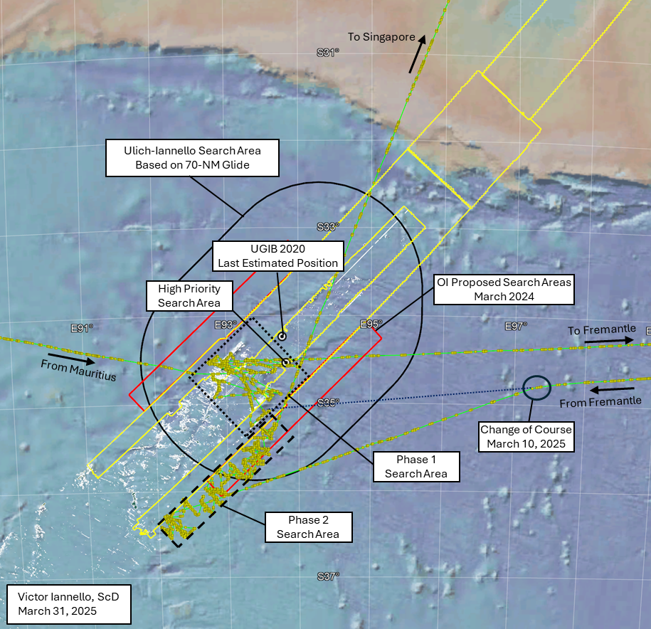
Last year, in March 2024, at a gathering in Malaysia on the 10th anniversary of the disappearance of MH370, family member V.P.R. Nathan presented several slides highlighting Ocean Infinity’s willingness to conduct another subsea search for the debris field of the aircraft. The search area proposed at that time extended along the 7th arc from about 33°S to 36°S, and out to about 45 NM (83 km) on either side of the arc. Ocean Infinity also announced plans to “fill-in” areas that were previously searched that had low quality or missing data due to equipment failures or challenging terrain. The proposed search area surrounded the “Last Estimated Position” (LEP) from UGIB 2020, which was designated the “IG Hotspot” in the slide. The proposed search area also incorporated our High Priority Search Area due south of the LEP that was missed by the previous searches by the ATSB and Ocean Infinity due to the steep sloping terrain in that area.
More recently, there were the following developments:
- On December 20, 2024, the Malaysian government agreed “in principle” to a new search effort with Ocean Infinity, indicating the start of formal negotiations.
- On March 19, 2025, Malaysia’s Transport Minister Anthony Loke announced that the Malaysian cabinet had agreed to the terms and conditions of the agreement with Ocean Infinity under a “no find, no fee” arrangement, with a payment of $70 million if successful.
- On March 26, 2025, a group representing the families of MH370 victims announced that a no-find, no-fee contract was signed by Malaysia and Ocean Infinity. Despite this announcement, there has been no official confirmation from either Malaysia or Ocean Infinity.
In February 2025, with no signed contract in hand, Ocean Infinity began the search that was proposed the year before. After completing two phases of the subsea search, Armada 7806 and its team of three AUVs is now on course to Singapore. Prior to departing for Singapore, the activities conducted during the two phases can be summarized as follows:
Phase 1: After arriving in the search area after departing Mauritius, this phase of the search began on February 23 and was completed on February 28, before departing to Fremantle to reprovision and resupply. The areas searched during this phase (dotted black box in the figure above) were primarily areas previously searched by the ATSB and by Ocean Infinity. Consistent with Ocean Infinity’s proposal from March 2024, the Phase I activities focused on infilling data where challenging terrain such as steep slopes previously resulted in missing or low quality data (data holidays). As such, most of the area in the Phase 1 box was not re-searched. The areas searched in this phase included our “High Priority Search Area”.
Phase 2: After departing Fremantle, Armada 7806 began searching again on March 11 and continued until March 28, before departing for Singapore. The areas searched during this phase (dashed black box in the figure above) were never searched before, starting further southwest and wider than the area proposed by Ocean Infinity in March 2024 (red boxes in the figure above). This would suggest that Ocean Infinity intends to enlarge the search area from what was previously disclosed.
The reasons for Ocean Infinity concluding this part of the search appear to be related to worsening seasonal weather and also related to prior contractual commitments for Armada 7806.
An interesting event occurred during the return to the search area before the start of Phase 2. The course of Armada 7806 was originally towards a part of the area that was searched in Phase 1. Then, on March 10, there was a change in course towards the southwest to begin searching areas not previously covered.
If there was no change in course on March 10, the purple dotted line in the figure above shows where in the Phase 1 search area Armada 7806 would have reached. In fact, our prior article discussed the possibility that Armada 7806 was returning to a debris field that was detected during Phase 1. This area is shown in more detail in the figure below.
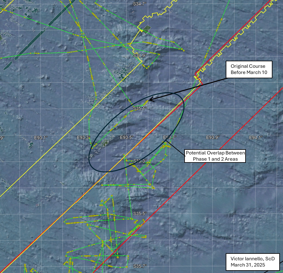
Shown in the figure by the black oval is an area that was possibly searched in both Phase 1 and Phase 2, which might mean a promising area required further investigation. However, as we don’t know the exact path that the AUVs followed after launching, there may have been little to no overlap between the Phase 1 and Phase 2 search areas.
So why did Armada 7806’s course change on March 10? Here are two possibilities:
- What resembled a debris field was found during Phase 1 and the plan was to revisit that area during Phase II to collect more data. Due to ongoing contract negotiations, OI strategically opted to not disclose the location of the debris field, and the course changed to the southwest. Some additional data in the area of the debris field might have been collected at the end of the Phase 2. (See the potential overlap area in the figure above.) If the debris field was already found, it is unknown whether Ocean Infinity has met the requirements to earn the fee of $70 million, which may require the retrieval of one or more parts of MH370.
- No semblance of a debris field was found during Phase 1. Originally the plan was to begin the Phase 2 search where Armada 7806 originally headed and then progressively search to the southwest. For some reason, the plan was changed on March 10 to begin the search to the southwest and progressively search to the northeast, ending where originally planned to begin.
In any event, if the debris field was not found, we are hopeful that Ocean Infinity will return to the search area in November, later this year.
Acknowledgement: This article benefited from ongoing discussions with Mike Exner, Don Thompson, Bobby Ulich, and Andrew Banks.
Tags: AUV, debris field, Malaysia, MH370, Ocean Infinity, subsea
They didn’t find anything like you told you they wouldn’t.
I wonder if you ever think back to October 2023 when I tried to tell you the truth but you were too ignorant to accept it.
I’m going to haunt you like a curse for the rest of your life.
You allude to it somewhat in your article, but if Armada 78-06 found the debris field in this phase of the search, how likely do you think it would be that they would mask that fact by continuing to search northeastward, as if nothing had been found?
Thanks in advance ….
@VictorI:
Thanks for your previous comment mention that I’m not violating physics! From fresh research, I have additional confidence in my Java anomaly candidate site. That would leave your option 2 of nothing found in the data holidays, consistent with OI continuing an expanded search. We can hope for some confirmation that a contract has been signed. Meanwhile, it would be great if OI could slow down and gather some MBES bathymetry along the unexplored 7th Arc, if they have time. And, I’ll note that the tropical Java site can be searched at any time. No need to wait until November.
@Kenyon:
The public seismic data is not hard to find. I started off a decade ago acquiring data with MATLAB/OCTAVE scripts, with encouragement from Curtin. Nowadays, Python with the Obspy library is the way to go. Acquiring Iris/FDSN data, applying instrument corrections, and polarization analysis are intrinsic functions. If you’re not up for wrangling python, then I suggest consulting with seismologists.
I’ve recently acquired public 2014 data from two very broadband ocean bottom hydrophones operated by the Australian Antarctic Survey, placed 1,500 km apart. This has opened up a whole new range of experiments and astonishing results.
So, we are not stuck with just public seismic data for confirmation. There are hydrophones, too.
@Erik Geer: If the debris field was found before the contract was signed, and announcing that it was found would in any way jeopardize the claiming the fee, there would definitely be an effort to keep that information secret.
@Ashton Forbes: Get a life. Or maybe transport yourself through a wormhole.
@Victor Iannello
You do have to feel a little sorry for Ashton, Victor. I mean, typically children start to learn that what happens in cartoons isn’t real around age five, whereas this fellow seems to have missed that realisation, and has based his entire thesis on an animation. Probably a good thing he hasn’t seen Disney’s Planes.
@Ashton Forbes
All of us have a right to our opinions. But in expressing them, I would argue that we should do so civilly, and without threatening those that we might disagree with. Please give this notion some consideration.
Thank you ….
I know next to nothing about maritime operations but I don’t think there is much significance to the change of course on march 10 other than someone making a decision based on weather forecasts for the search area. They likely knew in advance that they wouldn’t be able to cover more than half the length of the proposed area before the end of the season. By initially heading roughly for the center, they could decide spontaneously which half to go first: Center to south, center to north or – go all the way to the southern end if the weather permits it. The explanation probably lies in march 10th weather data.
@Ed,
My question wasn’t well formed. I have found multiple resources that have seismic data for thousands of events, I just can’t seem to find data for the seismometer stations listed on your website for the JA seafloor impact timeframe on March 8th. My assumption some time ago was that perhaps the magnitude wasn’t high enough for the nearby stations to report or I perhaps I wasn’t looking at the right resources.
I use python quite a bit, today found and tried ‘PyWEED’ launching it through Anaconda. Ran fine, but it reported the roughly the same info on Sage and others. Does the Sage link you provided above have the stations’ data for the date and time presented on your website? Maybe I’m not seeing the obvious?
I’m unaware of Obspy, I’ll give it a go.. Any help finding the JA seismic data or if your could publish the basic data on your website that would be most helpful. Not looking to do any sophisticated data analysis that requires a seismologist, just looking for basic data that the stations reported.
@SG: We were tracking the weather and it was fine.
@370Location
I agree with VI that your position does not violate the laws of physics. I already stated that long time ago. However, it is not the same as saying that it has high probability.
In order to reach a position so close to Indonesia and crash at so late time demands an active pilot. Not just any pilot, but an excellent one. More importantly, keeping the airplane flying for so long time means (according to the laws of physics) that there is practically no free energy left. That means absolutely no fuel, practically no potential energy, and only an absolute minimum of kinetic energy to prevent stalling.
This means that such a late crash liberates very little energy. However, the energy liberated at your location is large. It is similar to a medium size nuke (not a Hiroshima bomb).
My guess is that you most likely observed a coal chondrite meteorite falling in the sea, or perhaps a very rare type of superhot lightning strike. Most of these rare strikes happen in the intertropical convergence zone, and your position is near that zone.
Is there any chance that OI will simply refuel, change the crew, and continue the search for one more phase before November ?
I hope we can receive, at the very least, some communication from OI confirming whether the contract has been signed.
@Rachid: It seems unlikely that OI would refuel and resupply in Singapore when Fremantle is so much closer. All indications are that Armada 7806 will not return to the search area after departing Singapore.
@Kenyon:
Tom, I see why you were stymied. The PyWEED page says it is an event-based downloader, built on ObsPy. So, it cannot help with MH370. The reason I called it the Java Anomaly is because the event is among the loudest of the day even on distant hydrophones, yet it was too weak to be cataloged seismically. (Also, because even strong M5.4 quakes don’t propagate well into the SOFAR channel.) You will not find the event listed in any seismic catalog, and therefore PyWEED cannot fetch the recordings. It may have been excluded from automated cataloging because the energy content is mostly higher frequencies, which are often ignored as “anthropogenic noise” rather than quakes which typically generate very low frequency waves that travel teleseismic distances, reaching more stations for analysis.
You would need to download the data from at least those regional sites, visually “pick” the P and S wave arrivals, then use TauP model timing estimates to triangulate the epicenter. I suggest looking at rolling kurtosis for accurately picking first arrivals. I found no epicenter code at the time, so I wrote my own optimization routine. It surprisingly converged on a shallow source within 1 km of the 7th Arc. I have also gathered 48 hours of seismic records from over 4,500 seismometers globally, in case other seismic phases might reveal the surface impact. Only about 45 of the ones selected on that Sage map show a clear indication of the event. The nearest IA network geophones are restricted. GE.CISI near the Java coast has the clearest record of the event, which I sped up 60x and saved as a sound file on my website. You can use those P and S wave arrivals to estimate the distance to the event, if you just want confirmation.
I’ve sought help here at guesstimating the probability that the Java event was geologic rather then a plane impact, which is why it was originally dismissed in the first acoustic analysis as a “low level quake in the Java Trench”. The lack of a cataloged quake does shift the probability.
@Viking:
To reach the Java site while matching the BTO pings, MH370 would have been flying at a low and slow holding speed consistent with maximum endurance, not distance. I estimated it at oxygen altitude for my waypoint path. Even at fuel exhaustion, there would be quite a bit of energy in a crash, whether high speed or ditching.
Still, you seem to be confusing the timing. The Java detection is consistent with a seabed impact 55 minutes after the 7th Arc BTO, as the plane would have been sinking. Tom Kenyon has attempted to estimate the energy of a forward section of fuselage hitting the seabed, but excluded the entrained water. Surface impacts, unfortunately, do not propagate into the SOFAR channel. Here’s a report on my attempt at using lighting strikes for calibrating the hydrophone locations, thanks to a database shared with me by Viasala:
https://370location.org/2017/12/ocean-lightning-strikes-compared-with-acoustic-event-detections/
Over 10,000 of the strikes were over the Indian Ocean. Some were indeed mega-strikes, the strongest over water was -710 KiloAmperes. You can see from my map on that page that none of the storms were anywhere near the 7th Arc. Almost none of the lightning strikes were detectable in the SOFAR channel.
In his first paper on MH370, Usama Kadri thought he was detecting a meteor strike. It instead matches in direction and pattern with ice tremors. A meteor strike would also be a surface event, so not likely detectable unless it was in shallow coastal water. There were at least three surface airgun surveys (blasts every 8-12 sec) happening in the NE SIO that cluttered the soundscape. The noise is strong enough that LANL didn’t attempt to use the CTBTO Diego Garcia hydrophone array in their analysis. I instead used beamforming techniques to isolate the noise sources.
The probability of a detectable meteor strike right on the 7th Arc 55 minutes after that last ping must be infinitesimal.
Consider that Vincent Lyne studied the acoustics, but dismissed vague “talk on the internet” about a “Java Anomaly” as the result of dynamite fishing. That would also be a surface event, and the two day record contains no other “blasts” along the 7th Arc.
TLDR; I have a lot of opinions about MH370 acoustics.
@Cessi: You claim you are “informed”. I provided you with two references (my previous article and Steve Kent’s video) which give some technical explanations as to why the historical WSPR data cannot be used to track MH370 and asked you report back with any errors. You also implied on another website that I am deleting or not approving your comments, which is false.
We’d be interested in hearing your technical arguments.
@Victor
Your paper investigating WSPR only shows that you (!) are unable to track aircraft using WSPR. It is not evidence that it is impossible altogether. You claim that the reflected signals would be too weak. However, concluding that a system specifically designed to handle weak signals will fail because the signals are too weak is quite a wild assumption.
@Adi
Not every “paper” meets the requirements to be considered a proper peer review. In science, a peer review requires an objective reviewer assessing another scientist’s work. To avoid subjective bias due to personal differences, a peer review should ideally be conducted in a blinded manner. That was definitely not the case here. Therefore, I strongly question the necessary objectivity of this so-called qualitative peer review. I also suspect a confirmation bias, as the goal from the outset seemed to be to disprove RG. This is not a scientific peer review—it’s a joke.
This bias seems to be commonplace here, as I am being called “uninformed” even though you know nothing about my scientific background. Such behavior and personal attacks are not a reliable basis for discussing science, as they prevent objective debate.
@Cessi:
I have no idea about your scientific background, nor is that important. You are being called uninformed because of the technical claims you make. If you want to have an objective technical debate, you need to make arguments that adhere to the laws of physics. That is not a personal attack. Nor am I “biased”, as you claim, any more than the laws of propagation, diffraction, and theoretical noise floor are biased.
Yes, WSPR is designed to detect weak signals. But the scattered signals off of aircraft at long distances are MANY orders of magnitudes less than what is PHYSICALLY possible to detect. It’s the attenuation caused by the scattering process that makes the signals undetectable. For some reason, this detail is ignored.
Even if the scattered signal were detectable (which it isn’t at the powers and distances of interest), it would be very weak compared to the direct (unscattered) signal, and would have no influence on the values recorded in the WSPR database. Only through numerical processing that makes use of Doppler discrimination could the scattered signal be separated from the direct signal, and this spectral information is not available in the database.
Some of us have set up experiments to scientifically measure the strength of scattered HF signals off of aircraft. As predicted, the scattered signal is orders of magnitude less than the direct signal, and could only be detected when the direct signal was extremely strong (transmitter power with hundreds of kilowatts) and the aircraft was fairly close (tens of kilometers) from either the transmitter or receiver. And then, the signal was detected only by using Doppler discrimination to separate the scattered signal from the direct signal.
I have encouraged Simon Maskell and Richard Godfrey to run their own experiments to compare the direct and scattered signals from aircraft. This could provide unambiguous evidence that WSPR can be used to track aircraft. I’ve even offered to help them set up the experiment. It would not cost a lot of money as SDR receivers and omnidirectional antennas are available at low prices. Years have gone by, and they have not run those basic experiments to demonstrate the physical principles. Meanwhile, Nils Schiffhauer and I have run the experiments, and the results are exactly as predicted–the scattered signals are only detectable at high powers and short distances, and only with spectral processing to separate the scattered and direct signals.
@Cessi,
It’s not “science,” if unconflicted peers/experts cannot verify or repeat the propositions. If you are unable to grasp this fairly fundamental concept, there is no further debate necessary or warranted. Victor’s “uninformed” moniker is clearly aimed at your position on this topic, and not at YOU the individual or your background. Everyone can see that.
Regardless, my best wishes to you. Clearly your passion on this topic is driven by your desire to find MH370, and resolve the mystery. I assure you that is perfectly in sync with others on here as well. Let’s wish the parties on the ground Godspeed for their endeavors later this year and hope for the best.
Best,
Adi
@Cessi
I am more practical. I do not agree with WSPR in part due I think it is missing flight path up the Straits and beyond. I feel like I can see some of the human logic going into the WSPR flight path. Having said that, my opinion WSPR path is closer to where MH370 actually crossed Arc7 than most of the other estimates. I think MH370 probably flew some distance from Arc7, so if you rent a ship, pls see me.
WSPR arguments are great. One person repeatedly shoots at the broad side of a barn and paints targets on the place where they hit. Then a thousand people come along and say “how can you say he is not a great marksman, look at all of these bullseyes!”. And you can’t say anything to convince them otherwise because understanding a set of coordinates on a map and a “tripwire” analogy is very easy, but explaining the flaws in the process used to get those results is pretty hard.
It’s a trap that’s very easy to fall into when analyzing large datasets. You believe so strongly there is some truth in the data, it’s just buried in the noise. Like a sculptor you diligently carve away and remove all of the implausible “outliers”, tweak parameters, try new methods, until at last you finally get the result you expected. It’s beautiful, it’s clear, it’s noise free, it’s exactly what you needed, because you in fact accidentally created it yourself.
I’d encourage anyone looking into e.g. hydrophone data to be very careful of this effect too. Ask yourself, how many parameters did you have to tweak, how much “irrelevant” data did you need to discard to get your result.
I don’t blame anyone for believing in this stuff. Wishful thinking is a powerful drug. It’s very hard to get out of.
@TBill: You base your agreement with WSPR tracking on how well its “prediction” aligns with your guess. What we are discussing is the physical validity of the WSPR tracking methodology, which is not dependent on how we might guess the plane was flown.
In fact, I would even say that the plane COULD be found in the WSPR hotspot. There’s nothing that precludes it. However, WSPR tracking cannot be used to discriminate that guess from any other guess, as it provides no additional information.
Transport Minister Anthony Loke confirmed that the government has signed an agreement with Ocean Infinity last week to resume the search for Malaysia Airlines flight MH370. When asked by the media on Wednesday (April 2) whether this renewed search would result in the discovery of the plane’s wreckage, Loke stated that the outcome would depend on the progress and success of the search efforts.
https://www.msn.com/en-my/news/videos/mh370-loke-confirms-ocean-infinity-will-resume-search-efforts/vi-AA1CadFX
> Victor Iannello: “I would even say that the plane COULD be found in the WSPR hotspot”
I would call it the Godfrey hotspot instead, so nobody can misread this as WSPR being capable of discerning any hotspot.
“whether this renewed search would result in the discovery of the plane’s wreckage […] would depend on the […] success of the search efforts”
master of tautology
@Charm
It’s interesting to see how you associate wishful thinking with believing in WSPR tracking but won’t acknowledge that the same applies the other way around. This is, after all, what’s known as confirmation bias—whether it’s someone convinced that WSPR works or someone determined to prove it doesn’t, only to unsurprisingly reach that conclusion when testing it. Wishful thinking is indeed a powerful force, influencing our minds more than we often care to admit.
@Cessi
All applied science has to conform to the laws of physics, either as already understood or very occasionally by revealing a prior error in the application of those laws. There have been theoretical studies by some that that imply through prior understanding of the physics of HF propagation that WSPR is unlikely (by many orders) to be able to track aircraft on the HF anomalies they produce. This comes as no surprise to people who have knowledge of over the horizon radar which has been developed independently in a number of countries and deployed in some for more than five decades.
So far proponents of WSPR don’t seem to be able to provide examples of tracked aircraft where the aircraft track was not already known. There’s plenty of examples of “pattern matching” WSPR anomalies to known tracks. It is unsurprising that out of zillions of anomalies in HF propagation that some can be hand selected to “confirm” a known track. That is not close to even establishing proof of concept IMHO – but rather wishful thinking or, the more contemporary application of hopeium.
I am not saying that WSPN will never reveal anything useful, but it’s unclear to me (with with some experience in processing low level signals) how the current methods processing of WSPR data can extract positional data. The WSPR tracking hypothesis not been presented in any meaningful way in WSPR papers published to date as far as I can tell. On the other hand, WSPR tracking is benefiting from excellent marketing of the concept to non-scientific types.
@Cessi: If you believe my conclusions on the invalidity of WSPR tracking is based on confirmation bias, you surely don’t understand the physics of why scattered signals are greatly attenuated. That’s why I say it is futile to try to persuade the uninformed.
I have heard no valid excuse for why the WSPR proponents have not demonstrated the underlying physics with simple, unambiguous experiments as others have done. If low power HF scatter off of aircraft can be detected at a distance of thousands of kilometers, that scatter should be measurable. If my analyses and experiments are not believed, they should perform their own. They haven’t yet.
@Cessi
In a previous comment you scorned criticism of Richard Godfrey’s work, claiming it was biased and labelling it a “joke”.
Can you please point readers towards a peer review of Richard Godfrey’s work that meets the standard you outlined?
@Victor, Perhaps some of the difficulty with the [mis]understanding of WSPR that people struggle with is this …
It seems to me that we are not talking about detecting scatter from an aircraft, rather the issue is the perturbations to the “normally” received signal, in SNR or some other measure, as a result of an aircraft transiting through the signal path.
I suspect that this has the same problems, in that the “normal” signal is subject to many other influences that can affect SNR, and not just an aircraft.
I do understand some of the complications, having played with low power VHF in my long distance past. I built all my 2M gear, both transmit and receive, and had fun with long distance contacts with only 100mW on 144Mhz.
@Andrew,
I have tried that line of reasoning, and according to @Cessi, peer reviews aren’t required to meet the standards of believability in some instances – such as this, conveniently 🙂
Good luck!
Adi
@Brian Anderson: Yes, what is calculated by WSPR trackers are perturbations of the “direct” (unscattered) signal. But if scatter were to influence (perturb) the recorded values in any way, the magnitude of the scattered signal has to be similar to the direct signal, whether the signals constructively or destructively combine. In fact, the scattered signal is MANY orders of magnitude smaller than the direct signal and will have no effect on the measurement. Meanwhile, as you say, other factors such as dynamic effects in the ionosphere and multipath interference will create strong fading that will strongly influence the measured values.
There is no reason to doubt established science, but that’s what the WSPR proponents are implicitly claiming.
MH370 must be found and Ocean Infinity should be getting strong support from ICAO. It appears however that the Malaysian and Australian governments are reluctant to push the search forward. The MH370 families must be disappointed.
I lived in Malaysia for two years flying fighters from a base near Penang. Also have about 5000 hours PIC B777.
I don’t care who is ultimately successful regarding the science as long as MH370 is found.
Malaysia’s Ministry of Transport just announced that the Ocean Infinity search effort has been suspended, at least for now. It’s supposed to resume at the end of the year. I don’t know if it’s due to contractual issues or OI needing to do a vessel resupply.
A controlled final glide would put the wreckage far beyond the existing search boxes. There could be up to 10x more area to search which would make the likelihood of finding the plane exceedingly remote. I don’t think any government would be willing to spend a billion dollars with no guarantee of success.
I think almost everyone wants an end to the MH370 mystery. Science is agnostic when it comes to picking sides but, with respect, time effort and money spent on hocus-pocus is not a means to hasten to that end (with the possible exception that discussion (AKA brainstorming) around the technical feasibility of pathways to investigation may sharpen thought processes).
As far as I can tell all of the hypotheses to the end point for MH370 depend on one or more subjective assumptions which are therefore subject to innate biases. There aren’t always absolute rights and wrongs, but there are certainly differing degrees of likelihood between those hypotheses.
That there is a significant number of MH370 end point proponents who appear to be blind to their own biases in the development of their hypotheses does surprise me somewhat. The prosecution of science isn’t always as stringent as it should be. Which is not a flaw in science, it is a flaw in the human application of science.
@Byron Bailey: Of course the top priority is that MH370 is found.
@John Laurens: A controlled final glide would not put the wreckage very far away from the existing search box if we take into consideration the BTO and BFO data from Inmarsat. The seventh arc constraints from satellite data provide strong boundaries on possible endpoints regardless of piloting technique(controlled ditch OR no inputs by the pilot in command). Ocean Infinity just covered the Blelly/Marchand area, which is an area based on final glide theory, integrating both the satellite ping data and aircraft performance limitations.
The wreckage might be further south than the Blelly/Marchand area. At that point you’re right, nobody will likely go search there because it requires even more resources without a guaranteed result, especially after multiple high-cost search operations have already been conducted.
Hopefully in the upcoming days, OI will find something interesting after analyzing the raw data from the last phase of the search.
@Rachid,
You wrote: “Hopefully in the upcoming days”,
Suggest: Hope does not factor in the search.
If you look at Phase 2 of the recent search it seems like steady persistent progressive area coverage.
The only available evidence is the movement of the surface vessel.
But this may be considered indicative of progressive coverage by the three underwater craft.
If you also look at the implied total area covered during Phase 2, then there may be sufficient time available (presuming searching restarts in late October or November this calendar year) to cover a much larger further area before weather “closes in” mid 2026.
It is not hope which might produce a result, but such persistent searching until a result is produced.
@Geroge G
I agree that results will come from science and persistent and methodical searching. I’m not saying that we should rely on hope alone. My use of “hopefully” was merely expressing anticipation for what the data analysis might reveal, not suggesting that hope is a factor in the search methodology itself.
@Rachid: What’s the absolute furthest south the plane could have reached in a controlled straight glide without any turns or doubling back after the seventh arc transmission?
Would that location allow for some debris to have reached the coast of Western Australia?
@John Matheson
Thank you for that announcement, that was missing in action. We have to wait for contract details (if that can be disclosed), but the correct answer was: yes they will do everything in their power to find aircraft.
@Adi
The sudden silence from that quarter is deafening. It’s quite incredible that some people consider criticism to be a “joke” in the absence of peer review, while no such standard is applied to the original work.
I’ve now determined the reason behind the apparent data discrepancies in the latest WSPR study:
https://www.dropbox.com/scl/fi/o5ys0coxzixr9l3aem73l/Data-discrepancies-in-1_1_2025-WSPR-study.paper?rlkey=ntg21v6dwdxyfwxx9cp52t4ho&st=kmpopri5&dl=0
Cases 1 and 2 erroneously use +27h/-3h time frame instead of the supposed +/- 3h (someone probably mistyped the wrong date adding 24h). In addition, case 12 uses +3h/-6h. I’ve confirmed with multiple links that when searched with this “correction”, the group of links corresponds to the flawed SNR% presented in the study.
More interesting than the error itself is the lack of integrity displayed in the response, and what this tells about the reliability of other parts of these WSPR studies.
I also finally got “banned” from his site after sending this dropbox link over email.
@eukaryote: Thank you for tracking this down. Unfortunately, few people bother to dig into the actual data as you have. I assure you that if WSPR data seems to show any ability to discriminate the position of a plane thousands of kilometers away, it is due to bias introduced somewhere.
@John Matheson
“That there is a significant number of MH370 end point proponents who appear to be blind to their own biases”…true but it is more complicated than that. Blaming the pilot has sensitivities for the public, Malaysia, many pilots, and some aviation industry supporters. Also there is a assumption that says if there were active pilot maneuvers, then we cannot find it. Since I think there probably were maneuvers, I am a pessimist re: actually finding. But the flip side is many key stake holders accept all that above, in other words, many accept the ground rules above and that we may not find MH370, but are hopeful that it might be found.
eukaryote,
In answer to your question from Mar 27, the number 1108 at the 20:04 mark is in error (introduced when transposing from my notes to the slide) – it should be 1103. The other numbers, however, should be correct, and the conclusions are unchanged.
@sk999
What makes the ADS-B table confusing to me is the inclusion of multiple 2 min time slots with some of the cases instead of the 0/+6 min laid out in the study description. I still don’t know why that is, but fortunately this didn’t affect cases 1, 2 and 12 so I could mostly ignore it.
There also aren’t clear rules about how the 48 flights and timings were chosen, and I’m no longer sure I can trust that this was the original random selection.
@TBill
Thank you for your considered comments.
When I wrote that I had in mind those ‘experts’ who, upon for whatever reason having satisfied themselves with the veracity of their hypothesis, proceed to search for pattern fitting to support it, whilst disregarding data that doesn’t. Without pointing fingers I’m sure people can think of quite a few examples.
Unfortunately the media has limited penchant to apply critical thinking to different theories – they exist to sell content, not scientific integrity per se.
There is a chance, however small, that the plane will be found in nearest proximity to a spuriously predicted endpoint, allowing the proponent to bask in undeserved glory. Unfortunately that is a consequence of inherent uncertainties in the assumptions that all trajectory to endpoint models have.
@eukaryote
Your uncertainty with regards to the randomness of either or both of the flights selected and the times applied is particularly well founded, for when it comes to cherry picking, these fellows make the good people of Yamagata Prefecture, Japan look like clumsy amateurs.
You might recall their December 2023 (ahem) “technical paper”, How does WSPR detect Aircraft over short Distances?. That paper looked at purported “detections” of aircraft as they supposedly affected WSPR transmissions between transmitter W8AC in Chardon, Ohio and receiver N8GA in Miamisburg, Ohio, some 252 kilometres apart.
The “paper” stated,
“During the 3rd November 2023 a total of nine flights were analysed with different types of commercial aircraft including Boeing, Airbus, Embraer and Canadair flying at altitudes between 7,350 feet and 37,000 feet in the vicinity of the transmitter W8AC. Eight of the nine flights were detected with a total of 13 SNR anomalies. In two cases flights were additionally detected by frequency drift anomalies.” (p.2)
On the face of it, one might think that a raw detection rate of nearly 90 percent is most assuredly something to write about. However, it quickly becomes apparent that the nine flights selected were likely specifically curated to produce the extraordinarily high detection rate.
The nine flights addressed covered a 10.23 hour time period from 09:20 UTC – 19:34 UTC (05:20 – 15:34 local). It turned out that during that time period there were some 140-odd aircraft, ranging from Embraer Phenom small passenger jets all the way up to B777s, B767s and even USAF C-17s, that impinged on either the long or short path while WSPR spots were being recorded between those two stations. When you examine the spot data for all of those impingements, you find an actual detection rate of less than half their 8 out of 9 claim.
Basically, you cannot take anything that is produced by that trio at face value.
How does everyone really feel about the radar targets published from over the Malacca Strait? Before the FMT?
Confidence?
@370Location
In case your signal came predominantly from a seabed impact, most of its energy would have gone into seabed R-waves. I found strong evidence that was not the case. Instead, most of its energy went into waves propagating above the jump layer. That would never occur in case of a dominant seabed impact.
Instead it is consistant with a lightning strike or a coal chondrite. An iron meteroite would put more energy in the SOFAR channel and/or seabed R-waves, depending on its impact angle.
I personally beleive most in a coal chondrite impact. They are actually quite common.
@William Shea
Interesting question. I presume you mean those collected by Singapore, but later debunked or perhaps just ignored since they did not seem to fit in? Do you have technical details of them?
@William Shea: I think you are referring to the slide shown to the NOK at the Lido Hotel in Beijing in March 2014.
Either:
1. The radar targets are valid but Malaysia decided to later not release them. For instance, the radar data released to the ATSB contained no targets between 18:01z and 18:22z. Why not?
2. The radar targets are not valid. But then, why did Malaysia show them to the NOK and claim they were MH370?
For either case, Malaysia is being deceptive.
I tend to believe that (1) is more likely because the targets align with the civilian radar data and the Inmarsat BTO/BFO data.
Thank you all for response. I do not have anything to contribute. I wish I did.
Was hoping by now, there would be some newly discovered radar data or possibly new interpretation of existing data.
Thanks.
I wonder what Armada 7806 stopped to look for at 6.4S, 103.4E? It’s not like it was on their way to Sunda Strait. Obvs nothing to do with MH370 as it is so far from Arc7 / Ed’s Java anomaly candidate.
@Mick Gilbert,
“You might recall their December 2023 (ahem) ‘technical paper’, How does WSPR detect Aircraft over short Distances?”
Yep, but I never downloaded it. So important, that I now find that when I go looking for it, it has vanished – into thin air. Didn’t even leave the slightest smidgen of a recordable doppler shift on it’s progression into the ether.
Hello all,
First time poster but have been following the MH370 case for years. Godfrey has stated that the US military within 24 hours of MH370 going missing had analysed the BFO data and sent out aircraft to search around the 7th arc. This is the aircraft Captain Smith supposedly saw the day after MH370 went missing. Is it all possible they had this ability to figure out potential crash sites so soon while the rest of the world was looking in the south China Sea?
@Barry Carlson,
If you wish, using Richard Godfrey’s site you will find: “WSPR as Radar
by Richard Godfrey | Dec 18, 2023 | ”
The accompanying (there linked) “technical paper” is that to which Mick Gilbert referred.
(So you don’t miss out)
@George G,
Thanks for not letting me ‘miss out’.
The paper is also linked to from the Airline Ratings website, but the PDF file has been deleted from DropBox. I wonder why.
@George G,
I’ve read the paper, but still missed out… on the physics behind detecting a specific aeroplane, or indeed how a particular aeroplane could be identified and tracked without it already being known where it is.
It’s rather charitable to call the document a ‘paper,’ at least in the sense of scientific publications, because it’s lacking key details, like the mechanism of how the detection is supposed to work (within the laws of physics), how the theory can be objectively tested, and how the 20,000 or so WSPR sites and 20,000+ aeroplane movements per day are filtered down to track a single set of coherent anomalies from potentially many 100s of millions of anomalies generated each day. And that’s before even factoring the anomalousness of HF transmission and ionospheric behaviour, which would need to be quantified and accounted to isolated aeroplane induced anomalies, plus other sources such as marine traffic.
Chris asked: Is it all possible they had this ability to figure out potential crash sites so soon while the rest of the world was looking in the south China Sea?
It’s impossible to prove what somebody did or did not know, but it’s unlikely that the US was able to interpret the BTO/BFO data and operate on that knowledge all within around a day of the disappearance.
@Chris: Besides the Malaysian military radar data, there is also the possibility that a Singaporean airborne surveillance system, the G550-ELG550-EL/W-2085, detected a radar target or SIGINT from MH370 and forwarded that information to the US.
https://mh370.radiantphysics.com/2017/02/11/singapore-radar-and-mh370/
Captain Smith’s testimony raised an interesting point. Eventually, he confirmed that he flew on March 8 actually.
But focusing on March 7, 2014, UTC in the southern Indian Ocean, after flying around Sumatra, flight MH370 likely crossed paths with a very small number of other flights. Data retrieved from the FlightAware web pages shows that it likely crossed paths with four other flights. Using the piloted flight path reconstructed by Captain Blelly and J-L. Marchand as a reference trajectory, the shortest estimated crossing distance is only 12 nautical miles for two of these flights. Flight MH370 could not have avoided seeing them. These flights did not see it because of the dark, moonless night, because its external lights were probably off and because it was likely at a lower flight level. The flight formation of these two aircraft flying between flight levels FL320 and FL380, one directly above the other, suggests that flight MH370 crossed them from below, which corroborates the flight level FL300 calculated in the reference trajectory.
The report with its video summary and the data are available at https://www.mh370-caption.net/index.php/possible-mh370-encounters-in-the-southern-indian-ocean/
The data about the 91 identified flights is in csv format for ease of use.
@VictorI. Captain Smith in his statement refers to HIS sighting, ie in the singular. It remains a puzzle to me as to why he makes no reference to confirmation of that or otherwise by his Captain of that flight. Just no mention.
Yet so far as I am aware Captain Smith has not been asked about this or an explanation sought from his Captain, such as being absent from the flight deck at the time.
Surely though he would have been alerted to this, particularly since, as Captain Smith notes, “the aircraft came through our block”.
Besides, this having been reported to the airline, surely he would have a view?
@Chris,
According to an early report by Martha Raddatz on the US news channel ABCNews , the US military may have detected MH370 in the Indian Ocean.
It could have been a signal detected through an Over-the-Horizon (OTH) radar in Diego Garcia, or the SOSUS network to detect submarines, or the Australians lied about JORN being unavailable.
“We have an indication the plane went down in the Indian Ocean,” the senior Pentagon official said.
The official initially said there were indications that the plane flew four or five hours after disappearing from radar and that they believe it went into the water. Officials later said the plane likely did not fly four or five hours, but did not specify how long it may have been airborne.
https://abcnews.go.com/International/us-officials-malaysia-airline-crashed-indian-ocean/story?id=22894802
@Chris,
Also, there is a credible eyewitness report of a US military person attached to the TUDM who was informed that Malaysian F-18’s with external fuel tanks were sent to search the Malacca strait the same night of MH370’s disappearance.
https://www.youtube.com/watch?v=xlJBS9yRVpU
@CanisMagnusRufus
That article says nothing about the US detecting MH370, rather it talks about “an indication”. The “indication” at that time was almost certainly the evolving interpretation of the Inmarsat data.
@CanisMagnusRufus
It was reported by Reuters that a senior Malaysian military official admitted the military had tracked an unidentified aircraft heading west across peninsular Malaysia the night MH370 disappeared. Military officials also claimed that fighters were not scrambled to intercept the aircraft because it was not viewed as “hostile”.
Reuters Exclusive: Malaysia starts investigating confused initial response to missing jet
Nevertheless, it’s quite possible the military did send fighters to search for the aircraft at first light, even though the official search didn’t move to the Malacca Strait and Andaman Sea for several days. That could fit with “Gonky’s” story in the video, given he dropped his parents-in-law at Penang airport in the morning and then went to work, where he spoke to the fighter pilots after they had returned. If that search did happen, I don’t think it’s ever been admitted to the public by Malaysian officials.
On the subject of the US military detecting MH370 in the Indian Ocean, is there any evidence to support such claims, or is it speculation? The ABC News report you cited is dated March 13, two days after Inmarsat had provided investigators with analysis that showed the aircraft may have headed south into the Indian Ocean. Given that US officials were part of the investigation team, the “indications” mentioned in the report might well be based on Inmarsat’s analysis, not work done by the US military.
@Jean Luc
I greatly appreciate some of your videos of air traffic. Those are nice contributions. According to my studies, EK425 out of Perth hit Arc7 right about cash time at about 20-22s, so if MH370 had unexpectedly gone that way (eg; Ed Baker’s theory) then it could have been close.
@All on Radar etc.
I recently came up empty-handed on a MH370 Freedom of Info Act (FOIA) request of FAA. I was told all documents are beyond the retention date (discarded).
Clearly the joint investigation team (including FAA) likely had more radar data including Thailand reportedly saw MH370 in Andaman Sea (I recently posted media reference on Twitter aka X). Per Victor, Singapore either saw something or did not see something, which we’d like to know the answer in either case.
I do feel there was an effort to give researchers enough data to try to find the aircraft, but some data is sensitive, for example sim data we did not get a leak for 2 years and it was incomplete.
In other news, I’d be shocked if USA was searching Arc7 on the first day, before Inmarsat even had a chance to study their data. There is not the slightest indication of that. But I do think this break in the action is a good time to do FOIA requests…there is much data hidden still.
@Andrew, Mick Gilbert… thanks for the response. Yes it was speculation, but not mine. It was something written on some military blogs.
@TBill … I’ve seen some videos of the French passengers going through security on some French documentaries about MH370.
Can someone ask the Malaysians to release the full video of the passengers going through security? It would be really interesting to take a look at the 2 Ukrainian passport holders to answer the following questions:
– do they actually look like the people on the photos that JW released?
– do they actually have the physique of ‘marines’ as FdC wrote on her book, or is it just the imagination of a middle-aged single white woman living on a boat in HK?
– were they actually wearing identical black clothing, and carrying identical baggage, or is it just an artifact of the black and white security camera?
– what can be ascertained about their demeanors?
I approached FdC about this but she was non-committal. Looking closely at her theories, she seems to be playing upto the anti-US audience and making $$ while at it.
@All,
Armada 78-06 berthed adjacent to 53 Shipyard Road, off Pioneer Rd., at 1045 SGT
@BarryC
That is the Mooreast Offshore Base in Singapore. OI has been using the facility for some time.
@Victor
Do you have some information about which time-window(s) the Singaporean G550 airplaine made observations near the NW point? Without such information it is hard to use the NW position data to distinguish between different models.
Perhaps we may be able to infer some indirect information from the ‘curved paths’ proposed initially (if they relied on G550 data), but it will be highly uncertain information.
@Viking: The statement from the ATSB says that at 19:11z, there was NO detection from the Singaporean radar source, and that set the position of the NW point. In the article, knowing the NW point is 8° 35.719’N, 92° 35.145’E, I tried to back out what that might imply about possible locations of the G550 and further implications on possible MH370 paths, but that’s not easy to do with the limited information. In the end, the ATSB chose to ignore any information related to the NW point.
https://mh370.radiantphysics.com/2017/02/11/singapore-radar-and-mh370/
@Viking,
As noted above, I was provided a database with 48 hrs of lightning strikes in the IO that day, down to weak 10 kiloAmp strength. The was no storm near the Java Anomaly site, and even the largest 500 kA+ strikes are surface events that do not propagate into the SOFAR channel. How then could one of the loudest SOFAR hydroacoustic events within 15 hrs be from a lightning strike?
Meteorites of the size required are bolides that leave huge infrasound sonic booms as they decelerate and fragment on entry at altitudes up around 20 km. After slowing, the pieces fall at terminal velocity. The CTBTO analyzed infrasound for reports of such an event and found nothing. It would also be a surface event, unless you’re talking about the rubble drifting down to the seabed. If you are convinced the sound was made by a meteorite, then perhaps it would be big enough to be cataloged by IR detecting satellites.
You clearly have lingering doubts about the source of the Java Anomaly on the 7th Arc possibly being related to MH370. My acoustic research continues, characterizing previously undetected waves.
@370Location
My point is that the event deposited most of its energy in the upper couple of hundred meters of the ocean. That is what I call the ‘above jump layer’ mode.
Second-most energy went into the SOFAR channel, but this energy was less than in the ajl. Never the less you say that it was the largest SOFAR signal for many hours. You are probably right about that, but it just emphasizes how enourmous energy went into the ajl. Therefore it must have been an event comparable to the impact in Chelabinsk (Russia). That one was hard to find in IR satellite signals. After a couple of weeks some experts found it, but it was a small signal.
Least energy went into seabed R-waves. That is directly inconsistent with a dominant seabed impact.
Therefore I think the only way it could have been MH370 crashing would have been a very late crash. However, that means low energy, unless the airplane was carriyng a nuke (probably not realistic).
@Victor
Do you agree that NO detection at that time and place indicates that the curved paths were developed because G550 did not see anything resembling MH370 during its entire flight? That implicates a late FMT.
Initially, it would have been entirely reasonable to assume that MH370 flew slowly and along a curved path. Particularly since that also improbed agreement with the received power.
@Viking: I think we have to be careful about drawing conclusions about statements we don’t fully understand. In the article I cited, I tried to draw some conclusions about possible paths, but it was all speculation.
According to posts on other blog sites the Chinese deep sea research vessel Tan Suo Yi Hao is currently conducting activities in the vicinity of Lyne’s hotspot.
This vessel has been circumnavigating Australia for the past few weeks including passing through Bass Strait between Tasmania and mainland Australia, but apparently has recently changed focus.
Has BFO and BTO data from the same Inmarsat satellite through which MH370 communicated been analyzed for any other flights on or around March 8, 2014 whose flight paths are well known? I was wondering what analysis has been done to assess (1) how accurate/reliable the satellite’s historical BFO and BTO data is, and (2) the accuracy of the methodology for computing the relevant arcs based off that data.
The idea of there being some extra evidence the militaries don’t want to disclose to protect the secrecy of their capabilities is fun to think about. But I don’t think there will be anything interesting from in that data. There’s really only three scenarios:
1. Military assets picked up information that would significantly impact the search location. In this case, they would have likely found a way of covertly revealing it to the investigators. For example via the US intelligence practice of “parallel construction”. Say, by claiming a submarine in the area picked it up. Or just giving the investigators a nudge. Even if they were somehow unwilling to reveal it, at least one person who knew such significant information would have surely had the urge to brag about it or a moment of consciousness and leaked it. See the flight sim data.
2. Military assets picked up the plane, but it merely corroborated existing information. In this case, there is no point in disclosing their capabilities just to confirm existing data. Even if it tracked the plane slightly further out than civilian radar, there’s no point in revealing that if it matches the predicted track anyway.
3. Military assets did not pick up the plane. In this case there is no point in disclosing their lack of capabilities. If anyone believes you should have seen it you refuse to comment, claim it was offline for maintenance, you lost the data, or some other excuse.
@RazU: The BTO and BFO models were validated by Inmarsat (Ashton et al, The Search for MH370, Journal of Navigation, 2014) and the DSTG (Davey et al., Bayesian Methods in the Search for MH370, November 2015). Included were past flights for 9M-MRO and contemporary flights of MH370. The statistics for expected errors of the BTO and BFO were determined from these flights, as well as on the ground data from 9M-MRO before MH370’s takeoff.
@Charm: I tend to agree with you that the collective militaries have no further data that could help find MH370, but I see no harm in pursuing those leads.
@Victor: Exactly what I was looking for. Thanks! (And looking forward to the next weeks of reading.)
@Viking wrote:
“Second-most energy went into the SOFAR channel, but this energy was less than in the ajl. Never the less you say that it was the largest SOFAR signal for many hours.”
I get your point, but apparently am unable to convey mine. You are still conflating the undetected surface impact with the anomalously loud seabed impact. If even a small portion of the MH370 crash energy went into the SOFAR channel, it would have been detected. The hydrophones are dominated by clutter from multiple surveys using towed airgun shots. They are in relatively shallow coastal water, which allows the reflections from seabed and coastlines (upslope/downslope T-wave mechanism) to enter the SOFAR channel as H-waves. That doesn’t happen over deep water.
If we had been talking for years about the Java anomaly being among the loudest hydroacoustic events of the day with 7th Arc impact timing, there would be no question that the source was MH370.
Regarding your earlier comment about most of the energy of a seabed impact being R-waves, the CTBTO hydrophones are suspended in the SOFAR channel, so not well poised to pick up seabed waves.
@All
Just a note on the EK407 sighting by Capt Martyn Smith of a close call with an unidentified flight in the SIO on Mar 8 2014. The unfounded WSPR detections and extrapolations from that are ridiculous. If it were indeed a military plane on the correct heading from Diego Garcia, most likely it was on its way to Butterworth AFB or wherever multiple countries were converging assets to join the search effort near IGARI at the time.
@370Location
The US Navy reported that a P-8A Poseidon arrived in Kuala Lumpur on 14 March to assist with the search effort. That aircraft subsequently re-deployed to Perth when the search moved to the southern Indian Ocean.
Pacific Fleet Commander Recognizes P-8 Squadron MH370 Search Efforts
It’s hard to believe the US Navy would have deployed an aircraft to Kuala Lumpur for local search efforts if the US already had information that MH370 had gone south. That tends to debunk the notion that P-8A aircraft were searching the Indian Ocean on 8 March, as claimed elsewhere.
@370Location
Concerning the energy distribution, I am in contact with two geologists in Australia. They have data from detectors predominantly sensitive to ajl signals. They are totally baffeled which type of event could have put such a large amount of energy into that mode. It is something like a magnitude 4.5 earthquake on the surface of the ocean.
For comparizon there was an explosion in a depot for fireworks in the Netherlands while I worked there. It involvolved 300-500 ton of explosive material, and practically leveled a medium-sized town with the ground. The liberated energy equaled a magnitude 2.5 earthquake. This event was at least 100 times more intense, since the other modes also carried some energy.
That means something like a 50 kTon nuke. There is no way an airlane with empty fuel tanks can liberate so much energy.
@370Location
To be fair, I need to explain why I still do not consider your solution against the laws of physics. The reason is that the meteroite may have hit MH370 just before impacting the sea – causing the large explosion. That would explain everything.
However, the probability is low.
@Andrew, Thanks for the info on the P-8A going to KL. Your conclusion is spot on.
@Viking variously wrote:
“My point is that the event deposited most of its energy in the upper couple of hundred meters of the ocean. That is what I call the ‘above jump layer’ mode.”
“I am in contact with two geologists in Australia. They have data from detectors predominantly sensitive to ajl signals.”
“…the meteroite may have hit MH370 just before impacting the sea – causing the large explosion. That would explain everything. However, the probability is low.”
Geologists typically use seismometers on land to analyze vibrations in the Earth’s crust, which are insensitive to remote ocean surface events. AFIK, the only “detectors predominantly sensitive to ajl signals” would be sonobuoys dropped by military aircraft near a suspected source. Do tell your source for an M4.5 surface event in the SIO.
Your new scenario of a rare huge meteorite striking MH370, not at IGARI causing the turnback, but hitting the improbably impaired plane just as it crashed hours later into the SIO, is, well, stunning.
We can agree that the the probability for that is low, likely incalculable.
Where is a statistician when you need one?
For those interested in aircraft accident report quality, clearly this is thorough, well presented and its findings useful, including seat belt fitment:
https://www.youtube.com/watch?v=dum4SfnX8uk
For those with a deeper interest, the complementary written report:
https://www.atsb.gov.au/sites/default/files/2025-04/AO-2023-001%20Final.pdf
@370Location,
“There are three kinds of lies: lies, damned lies, and statistics.” (Attributed to Benjamin Disraeli by Mark Twain)
@ Viking
Re: “That means something like a 50 kTon nuke. There is no way an airline with empty fuel tanks can liberate so much energy.”
I’m not sure what the discussion is regarding ‘50kTon nukes’ is about? To offer some perspective, running a quick monte carlo (2k runs) for MH370 impact with ocean surface using EOF spiral descent data from Victor Iannello, Mike Exner, and ATSB results in a fairly wide Kinetic Energy budget range of 1.1GJ to 9.7GJ with an average of 4.8GJ.
This KE budget could generate respective Seismic Energy budgets of 9.3kJ (min), 880kJ (max) and 241kJ (avg). The weak seismic signal (if any???) is more difficult to calculate but could be on the order of ~ -0.8 to 0.8 Mw. More calcs would be required to prove out tighter.
A rough (unchecked) calculation of source level power range 205–215 dB. Gforce deceleration rough order of magnitude is ~450g, largely occurring in milliseconds.
The Chinese deep sea research vessel Tan Suo Yi Hao has now tracked westward along the Diamantina escarpment to about 20NM or so from the 7th Arc. Trajectory here (from: Ocean Infinity News and Updates Facebook page):
https://scontent-syd2-1.xx.fbcdn.net/v/t39.30808-6/490349637_1229057655890750_7957958215321867623_n.jpg?_nc_cat=109&ccb=1-7&_nc_sid=127cfc&_nc_ohc=vNpKCyC22LEQ7kNvwEbz8lp&_nc_oc=AdmnGdaOm820gXsItz4PWzJ7D3TxAa6VbkQL6N_1OobXyTxNrvaAJOrN6GszozSzNBI&_nc_zt=23&_nc_ht=scontent-syd2-1.xx&_nc_gid=ZktZISFQyNHMLw2sZTkEsw&oh=00_AfG65sdxZyOCUv6ToTSqgJsyXVIkDKcsuo8LiGo5YC6QYQ&oe=68014E5E
@John
Whether the Tan Suo Yi Hao is hotspotting or otherwise, best of luck to the Chinese Vessel on it’s venture and research at this time of the year.
@John
@Joseph Coleman
The Chinese conducted a similar mission in early 2023, exploring the Diamantina Trench and other deep-sea features in the Oceania region. The present operation is very likely a follow-up to that earlier mission rather than a search for MH370, as purported by commentators on other websites. There is some speculation the present operation may have a military purpose, but that is not confirmed.
Seabed sensors and mapping: what China’s survey ship could be up to
All,
Jeff Wise so enjoyed my video on WSPR tracking that I thought it only fair to make one on his favorite topic – Kazakhstan.
https://www.youtube.com/watch?v=iTcjjc5N-98
@sk999, nicely done 🙂
I’ll just add one point which has sometimes been under-appreciated when considering a “northern route.” The probability of a foreign aircraft cutting across the Eastern seaboard of India, and then crossing over across the Northern border into Nepalese / Tibetan / Chinese airspace unchallenged is approximately equal to zero, even in 2014.
Best,
Adi
@sk999, … Thank you for thoroughly debunking the “takeover from EE bay” hijacking scenario. JW is famous for uncovering the backgrounds of the Russian and Ukrainian passport holders, yet his unwavering commitment to the “northern route” theory left him oblivious to its numerous flaws.
However, I find it hugely problematic that both JW and Florence de Changy (FdC) shy away from commenting on whether the persons who used the Ukrainian passports to board the plane are who they purportedly are.
By piecing together the details provided by JW and FdC, it can be inferred that the two Ukrainians might have been compensated and placed into a witness protection program, while their passports were potentially utilized by others to execute the so-called “unlawful interference by a third party.”
A few countries are notorious for “borrowing” the original passports of real people and using them for nefarious political activities.
@ sk999 … BTW do you know if the request to top up the emergency oxygen for the flight deck was conveyed via EICAS?
@sk999: Thank you for creating and sharing this video. My feedback: Unfortunately, every second sentence of yours starts with “Comrade Jeff”. This derisive tone and ad hominem attack is uncalled for and unfortunately distracts from your arguments, which I find generally solid – except for the first argument you present in your video: Jeff suspected an abduction to the north very early on. What is your point there? By itself, this is not a meaningful argument in my opinion. Granted, this fact can show a cognitive bias (which none of us is completely immune to, so I don’t think it’s clever to mock this) but it can also be the result of something else entirely: As more and more facts come to light, they may all neatly fall into place, fitting the same pattern (or jigsaw puzzle) and confirming a pre-established theory or hunch.
Bottom line: Your video would benefit from abandoning the personal attacks and focusing solely on the facts and factual arguments. This would be more scientific.
CanisMagnusRufus,
According to the Safety Information Report, the topping off of oxygen was a routine maintenance task. There is no mention of it being a response to an EICAS message or other notification.
Peter Norton,
Thanks for your feedback. Sorry for the apparent derisive tone of my video. However, I was quite annoyed that Jeff chose to embed my WSPR video prominently in the middle of his own latest ad hominen attack, with which I desire to have no association whatsoever.
@Victor/all
Just a brief comment on the China research vessel, if I were going to search that area, I would first consult with Bob Ballard. I am thinking Ballard would search for debris trail in wider search zone inside but also outside BR proper. which is not what the Chinese survey is doing.
Hardly a day goes by without someone suggesting MH370 has possibly been found by OI or the China research vessel. Wishful thinking unfort, although the first group getting close to the correct crash spot could have quick success, if luck be with us.
@CanisMagnusRufus
I may have some input for you on your query of April 7 re: PAX video boarding. It is not my personal focus but I have info coming to me from others. In short, the PAX videos are NOT thought by some to corroborate FdC and JW characterization of several PAX as suspicious military muscle men.
Very well said on all counts, @Peter Norton!
Adi
@sk999 wrote
> Peter Norton,
> Thanks for your feedback. Sorry for the apparent derisive tone of my video.
> However, I was quite annoyed that Jeff chose to embed my WSPR video
> prominently in the middle of his own latest ad hominen attack, with which I
> desire to have no association whatsoever.
@sk999: Thank you for listening and responding. I was completely unaware of any background stories between you and Jeff and I can fully relate to your annoyance if your video was misappropriated.
Even if your annoyance is justified (and I am not here to judge this) I just wanted to let you know what impression an oblivious bystander like myself gets from this video.
Regardless, your technical arguments are well presented and really helpful to those of us who are less familiar with the technical details of a Northern route. So thanks a lot for your efforts in producing this video. Much appreciated. I have watched half of it yesterday and very much look forward to finishing it today. Cheers.
@sk999:
@CanisMagnusRufus:
@Andrew:
re: “the topping off of oxygen was a routine maintenance task. There is no mention of it being a response to an EICAS message or other notification.”
Famous Youtuber “Greendot Aviation” covers the topic of the oxygen replenishment in his MH370 video https://youtu.be/MhkTo9Rk6_4 at position 00:30:40:
« As for his own oxygen supply, he was at no risk of running out. His supply came from 2 large tanks underneath the cockpit which had enough oxygen to last 2 pilots 13 hours or 1 pilot 27 hours. These tanks are topped up a few times each year and luckily for Zahari – or perhaps more than just luckily – this oxygen supply had been topped up that very evening just before the plane had departed Kuala Lumpur. Take a look at this: It’s a scanned copy of the actual tech log from flight 370. This is one of the last pieces of paper generated by the flight before it left Kuala Lumpur. The tech log is the booklet where engineers and Pilots note down any faults with the aircraft and whether they need fixing before the plane goes on its next flight. There are 2 things which stick out in this document: First, under “defect description“ the engineer wrote “nil“ and “nil notes“ – in other words: no maintenance needed. He also crossed out these fields to show that nothing was needed. But then sometime later that evening, an engineer did make an entry: “crew oxygen system replenished to 1800 PSI“ – sometime between when the plane arrived at Kuala Lumpur earlier in the day and when it left again that night as MH370. Somebody decided that the pilot’s oxygen needed to be topped up. Whether it was Zahari has never been determined. »
Here are said tech log pages:
* https://archive.is/PTsYs/97e6938133f77ed337346232e48f8f41301fd996.webp
* https://archive.is/PTsYs/6afb5ec7bac3699d717d311860a4d458c7dd4965.webp
Also mentioned here:
https://www.mot.gov.my/my/Laporan%20Siasatan%20Mh370/02-Appendices/Appendices%20Set%201%20-%207%20Appendices%201.1A%20to1.9A/Appendix-1.6A-RecentTechnicalLogEntries.pdf
——————————————————
S/N 4918752 – 07 March 2014
Night Stop. Crew oxygen system pressure reads 1120 psi (EICAS).
07 March 2014
Crew oxygen system replenished to 1800 psi – EICAS.
AMM 12-15-08 refers
——————————————————
There is a related discussion at PPRuNe:
https://www.pprune.org/tech-log/583578-b777-crew-oxygen-system-2.html
B777 Captain Simon Hardy finds the replenishment very suspicious:
« There were also several last-minute additions to the jet that were shown in the technical log […]. The cockpit’s oxygen levels had been topped up before the flight […]. An extra note can be seen on the log, showing that the top-up was requested for the cockpit but nowhere else on the aircraft. Mr Hardy told the paper: “It’s an incredible coincidence that just before this aircraft disappears forever, one of the last things that was done as the engineer says nil noted[no oxygen added], then someone else gets on onboard and says it’s a bit low. Well it’s not really low at all… it’s a strange coincidence that the last engineering task that was done before it headed off to oblivion was topping up crew oxygen which is only for the cockpit, not for the cabin crew.” »
source: https://archive.is/nLm8P#selection-631.0-701.221
To a layman like me this sounds indeed suspicious. Not the replenishment itself but the fact that replenishment was not planned but than apparently overruled by someone else and the fact that (if true) only the crew oxygen system was replenished.
@Andrew: Could you maybe chime in to tell us from your professional experience whether or not this is something out of the ordinary ?
@Victor Iannello:
Was Simon Hardy’s hotspot in the Geelvinck Fracture Zone covered by the latest OI search ?
« He calculated the most likely position of the remains of the doomed flight. And he was invited to join the search with the Australian Transport Safety Bureau (ATSB) in 2015, where a team of experts were leading the hunt. But his calculations put the resting place for the plane just outside the official search area – and despite consulting on the operation, he never had the chance to prove his theory. […]
He suggests the plane’s pilot would have been in control the whole time – attempting to neatly plunge the plane into the ocean so it could never be found in a spot known as the Geelvinck Fracture Zone. The trench is hundreds of miles long meaning the pilot would have had manoeuvre room when deciding when to ditch the plane. […]
Another document of note is MH370’s operational flight plan. It which shows that an extra 3,000kg of fuel was added to the plane – the maximum amount of extra fuel that can be added to a Boeing 777 flight. The fuel would have given the pilot 30 minutes more flying time or more importantly, Simon explains, more time to ditch the plane in the ocean in daylight. He told The Sun:
“If you want to do a good ditching, you do it in daylight or at least half daylight. In the case of MH370, if the pilot has another half an hour of fuel it will be daylight. Another half an hour of flying would be another 244 nautical miles and the most important thing is that it will be dawn. […] Too much leftover fuel would leave an oil slick on the surface and reveal the plane’s final resting place. […] Even if you have tonnes and tonnes of fuel and it’s at the bottom of the Geelvinck Fracture Zone it still will be leaving a plume of oily rainbow residue on the surface for years. He wants to preserve the aircraft but he doesn’t want to save the passengers. It’s all part of it being planned meticulously for, ‘how can I make it disappear, I don’t want tonnes of fuel but I do wanna go as far as possible. If you’re of a motive to make it disappear then only one solution is to ditch it as neatly as possible, so it sinks to the bottom with all the people inside, with all the flotation devices inside, with no baggage. That’s what you want, if you want to make it disappear, you don’t crash it you ditch it.” »
source: https://archive.is/PTsYs
Personally, I think any water landing amid the significant waves and swell of the Roaring Fourties will obliterate the aircraft, no matter how hard you try. Keeping the aircraft hull largely intact like Sully on the flat Hudson River is not possible in the open ocean IMO. Or does anybody of you know a successful water landing in the open ocean ?
But even if it is impossible, this doesn’t necessarily falsify Hardy’s theory that whatever perpetrator could still have tried to do so (i.e. try to keep the aircraft in a few large and sinkable pieces).
@Peter Norton
Claims about the addition of extra fuel and oxygen, as reported by The Sun, are hyperbolic nonsense.
There’s no “mystery” about the “extra” 3,000 kg of fuel. That fuel is clearly shown on the flight plan as “COMP FUEL”, ie company fuel. Company fuel is fuel added by the airline to cover contingencies such as unplanned holding, based on the airline’s previous experience of operating to a particular port. Beijing and other ports in China are notorious for extended delays that have the potential to cause diversions and attendant disruptions to the operation. Consequently, airlines often carry “extra” fuel to mitigate that risk. According to Malaysian’s operations manual, extra fuel added by the captain is annotated on the flight plan as “SURPL”. In this case, no such extra fuel was added by the captain.
As @sk999 mentioned earlier, replenishment of the oxygen system is a routine maintenance task, normally completed at an airline’s home base during extended stopovers. In this case, the circumstances are outlined on p.47 of the MH370 SIR. Airlines typically replenish the system well before the pressure reaches the MEL minimum requirement for dispatch.
As for the notion that “extra oxygen was also added at the last minute but only to the cockpit“, words fail me. If they’d bothered to do some homework, they would have found that, unlike the crew oxygen system, the passenger system uses chemical oxygen generators that do not need to be replenished.
@Andrew:
Many thanks for your technical insights. I thought the “only to the cockpit” part may have some relevance since B777 Captain Simon Hardy heavily emphasized this point. But apparently (if I understand you correctly) this is not noteworthy because only cockpit oxygen can be replenished.
In another comment (pending publication) I asked you whether it might be suspicious that the replenishment was initially not planned but than apparently overruled by someone else (see tech log).
Maybe you can give some feedback once the full comment is published ?
Thanks again.
@TBill
No matter what one thinks of the theories espoused by JW and FdC, the evidence they revealed after investigating the PAX and the pilots is reliable. JW and FdC may be stubborn, but they’re not lying about the evidence. It’s upto us to interpret that evidence.
@sk999, VictorI, anyone
According to the Green Dot video, the request to top up the pilots emergency oxygen tank was issued after flight MH371 arrived from Beijing earlier that day. The handwriting on the Technical log notes on the left that it WAS 1180 psi, and the same handwriting notes on the right the Oxygen tank was replenished to 1800 psi.
1. is it routine to note the crew Oxygen level as per EICAS on the technical log before each departure?
2. is the technical log read by the pilots prior to takeoff? How long before takeoff? Is there enough time to replenish the oxygen before takeoff, or can it be something on a ‘to do’ list to be completed before the next flight?
3. could something have happened on the flight MH371 from Beijing to KL that prompted this request to top up the oxygen tanks?
CanisMagnusRufus,
If I am reading my manual correctly, EICAS provides the ability to display status information. Here’s a description of how it works:
===========
The status display shows information that helps the technician make a decision on the dispatch status of the airplane.
The status display shows:
– Hydraulic system information
– APU information
– Crew oxygen information
– Status messages.
You use the status display switch on the display select panel (DSP) to select the status display on the multifunction display (MFD).
=============
So it is possible that a technician made a routine pre-flight check of the EICAS status page, saw the low oxygen pressure, and had the oxygen system serviced. But I know nothing about MAS operating procedures other than what is presented in the SIR, so that is just conjecture. I also don’t know if the technical log entries are chronological, but just below the entry r.e. the oxygen is one stating that the software in the EPESC (a component of the IFE) had been downgraded. Don’t think that that would have been ordered by the Captain. In case anyone is interested, the EPESC is powered by the left AC bus via the P110 power management panel, same as the SATCOM.
@CanisMagnusRufus
This crew oxygen top-up is sadly yet another distraction put about by someone who frankly should know better.
Topping up the crew oxygen system was performed by MAS engineering staff as part of the stayover check after 9M-MRO had arrived into Kuala Lumpur as MH371 on 7 March 2014. This would have been carried out long before the Captain had even arrived for duty at 2250 hrs MYT.
Anyone who has taken the time to properly review the oxygen system maintenance records would see that MAS actioned Aircraft Maintenance Manual (AMM) task 12-15-08 Crew Oxygen System Replenishment essentially any time that the crew oxygen system pressure was reported as being at or below 1200 psi. It was a standard top up conducted entirely independently of the operating flight crew.
As to why the crew oxygen needs to be routinely replenished, Andrew and I spent a good deal of time researching this many years back. The reason for the replenishment is that oxygen is bled off from the system:
a. when the flight crew check the oxygen flow on each of the flight deck masks as part of their pre-take-off checks, and
b. on engine start-up, as part of an automated system pressure/volume check.
Draw your own conclusions as to why the entirely mundane is being promoted in such a fashion.
@Peter Norton
RE: “But apparently (if I understand you correctly) this is not noteworthy because only cockpit oxygen can be replenished.”
Exactly. The crew system has two oxygen bottles that are replenished as required. The passenger system, on the other hand, has individual chemical oxygen generators located in the passenger service units above each row of seats. When activated, the generators produce oxygen by a continuous chemical reaction between iron and sodium chlorate, for about 22 minutes. The generators are only replaced during major servicing, or if they have been activated for some reason. Unlike the crew system, the passenger oxygen generators are not ‘replenished’ during routine day-to-day servicing.
Regarding your earlier comment, these claims about the oxygen system replenishment are arrant nonsense. I’ll start at the beginning and work my way through your post.
1. Greendot Aviation said: “These tanks are topped up a few times each year…”.. My experience in close to 30 years of operating large Boeing and Airbus aircraft is that gaseous oxygen systems are replenished more frequently than “a few times each year”. The B777 crew oxygen system has an automatic safety feature that bleeds oxygen for 25 seconds during engine start. That function, together with crew oxygen checks and ‘normal’ leakage causes the pressure to reduce over time.
2. Greendot Aviation said: ”First, under “defect description“ the engineer wrote ‘nil’ and ‘nil notes’…” That statement is incorrect. The “Nil” in the “Defect Description” column would have been written by the inbound captain when he signed off the tech log after the previous flight. The inbound captain writes up the details for the flight and notes any defects that occurred in the “Defect Description” column. If there are no defects, that too is noted. The engineer then wrote up “Nil noted” in the “Action Taken” column.
3. The next entry in the Tech Log is the oxygen replenishment. Greendot Aviation said: ”Somebody decided that the pilot’s oxygen needed to be topped up. Whether it was Zahari [sic] has never been determined.” The MH370 SIR states that the oxygen system was replenished during the stayover check, because the pressure was reading 1120 psi. In other words, the engineers noted the pressure during the stayover check and topped up the system to 1800 psi. That action was not initiated by Zaharie.
4. Simon Hardy said: ”It’s an incredible coincidence that just before this aircraft disappears forever, one of the last things that was done as the engineer says nil noted[no oxygen added], then someone else gets on onboard and says it’s a bit low.” Where on earth did he get the idea this was a last minute addition to the Tech Log? The aircraft arrived from PEK mid-afternoon and was on the ground for over nine hours before it departed as MH370. At some time during that nine hour period, the engineers performed a stayover check and a software downgrade, as noted in the Tech Log. Both actions were very likely completed well before Zaharie got anywhere near the aircraft.
5. You said: ”To a layman like me this sounds indeed suspicious. Not the replenishment itself but the fact that replenishment was not planned but then apparently overruled by someone else and the fact that (if true) only the crew oxygen system was replenished.” The Tech Log entry was “overruled”. The inbound captain noted there were no defects during the inbound flight, and during the stayover check the engineers noted the oxygen pressure was 1120 psi and topped it up to 1800 psi. The reason that only the crew oxygen system was replenished is explained above.
In summary: There is absolutely NOTHING out of the ordinary about the replenishment of the crew oxygen system.
Thank you all for graciously answering my questions.
The following questions may seem bizarre (I guess most of my questions are like that, LoL!), but have you ever noticed that on some of his videos JW seems to slur some of his words and seems almost drunk? What’s up with that?
@CanisMagnusRufus
Adding to Mick’s comments:
You asked:
1. “is it routine to note the crew Oxygen level as per EICAS on the technical log before each departure?”
Normally, the oxygen pressure would only be noted in the Tech Log if the system needed to be replenished. As Mick explained, the engineers noted the pressure had dropped to 1120 psi, which is below the limit at which they take action to top it up, per Malaysian’s engineering procedures.
2. “is the technical log read by the pilots prior to takeoff? How long before takeoff? Is there enough time to replenish the oxygen before takeoff, or can it be something on a ‘to do’ list to be completed before the next flight?.
Yes, the Tech Log is read by the pilots before departure. The Captain reviews the work that has been done, notes any outstanding defects that may be allowed by the MEL, and makes sure the dispatching engineer has released the aircraft for its next flight. The Captain then signs the Tech Log to accept the aircraft. The Tech Log is reviewed when the pilots arrive at the aircraft, normally about 45-60 minutes before departure. The Captain may not be able to sign the Tech Log immediately, as the dispatching engineer often doesn’t release the aircraft until 10-15 minutes before departure.
Strictly speaking, oxygen replenishment can be deferred if the engineers are pushed for time, provided the pressure is above the limit required for dispatch, per the MEL. However, airlines normally prefer doing it at their home base, rather than down route. In this case the engineers noted the pressure was low during the stayover check and had plenty of time to service the oxygen system.
3. “could something have happened on the flight MH371 from Beijing to KL that prompted this request to top up the oxygen tanks?” If something had happened during the previous flight, it should have been noted as a defect by the inbound Captain. In this case, the Captain wrote “Nil” in the defect description column, so I think it’s safe to assume that nothing untoward happened during that flight.
@Andrew:
Thanks again for your detailed insights and answers.
You said: « The Tech Log entry was “overruled”. »
I assume there is a “not” missing after “was”.
I explain what I mean by “overruled”:
In the tech log there is a table. The left column header reads “defect description” and the right column header reads “action taken” (as you know of course). There are 3 rows (or horizontal sections) shown in the picture, each denoting a defect/action pair: row 1 (D1/A1), row 2 (D2/A2), row 3 (D3/A3).
My point of concern is the section A2:
It has been crossed out and then subsequently* overwritten (with “crew oxygen system replenished […]”).
*The reverse order would make no sense.
Could this matter?
My thinking is that normally this section is crossed out after all checks are done and no action (A2) was taken. I assume the section is crossed out to void it. To my laymen eyes it seems noteworthy that despite the section being voided, there was a subsequent action taken and noted in A2. To me, the crossed out section means that this action (oxygen replenishment) was initially unplanned. The person overwriting the crossed out section A2 probably was the same person who crossed it out initially: MAS 0053.
The question is: What prompted this change in the course of action ?
Maybe a change like this occurs quite frequently in practice and is not at all something out of the ordinary. But I would like to ascertain this.
The reason why I am focusing on this seemingly insignificant detail is the combination of
(a) the crew oxygen playing a key part in the mainstream/mainline theory about MH370’s diversion and
(b) B777 Captain Simon Hardy and Green Dot Aviation both finding this detail very suspicious.
In light of the extraordinary circumstances around MH370’s disappearance, such a detail may matter and I wanted to ascertain whether or not there is something out of the ordinary in the tech log.
BTW, is anybody able to decipher the vertically overwriting text in capital letters in A2 ?
@Peter Norton
My apologies – yes, I meant to say “The Tech Log entry was not “overruled”.
RE: “My thinking is that normally this section is crossed out after all checks are done and no action (A2) was taken. I assume the section is crossed out to void it.”
If a defect is entered in the left column, it is always accompanied by an explanation in the right column for any action that was taken, even if only to say “Noted”. The right column is never “voided” with a diagonal line if no action is taken.
The diagonal line may not be related to the writing on that page of the Tech Log. Paper Tech Log pages have multiple copies and are self-carboning. If you rotate the image 90° to the right and then flip it horizontally, you will find the “vertically overwritten text” appears to say “MRO Enter”. That makes me think the page depicted is actually a carbon copy and not the original, and that someone has written on the back of one of the pages. That writing has been transferred as a mirror image to the front of the page.
As I said previously, I don’t believe there is anything out of the ordinary about the replenishment of the crew oxygen system. People are making things up to justify various theories, without properly considering the evidence.
All: I am puzzled by all the speculation re the reason for topping off the O2. As Andrew and others have explained, it was SOP. Besides, Z had all the O2 he needed for his plan, even if the pressure had been only 1120 psi. He did not need more than an ~1 hour of O2. If he flew to the end, he probably repressurized the cabin circa 18:25. Alternatively, he could have simply removed his mask once the plane was headed south. Either way, there was never any reason requiring the O2 to be at max.
@Andrew
When looking for the reverse “MRO Enter” you mention I was immediately struck by the impression that the diagonal slash and the “MRO Enter” were written by the same hand/writing implement. Both certainly do not look to be written by one of the hands/writing implements as the service notes. That was just my impression – I am not in anyway a handwriting expert.
The impression came from seeing a ‘focus’ not unlike seeing the hidden 3D image in a “magic eye” photo, namely the the diagonal slash and the “MRO Enter” characters stand out from the rest of the form as though they were written on a different plane (no pun intended). Is it a coincidence the letters MRO are the identifier of the plane in question?
@Andrew:
Thanks for your follow-up. That was very clever of you to flip the image so that it reads “MRO Enter”! (I had only rotated it and wondered why I could not decipher the letters.)
If “MRO Enter” appears as mirrored letters, you are right that this mirrored writing must be a carbon copy from someone writing on the backside. This opens up the possibility that the diagonally crossing line “belongs” to “MRO Enter” (i.e. it was also written on the backside along with “MRO Enter”) — particularly if you say that in practice, the right column is never voided. In this case, it (the diagonal line and “MRO Enter”) probably has nothing to do with the maintenance report and the crew oxygen.
re: “People are making things up to justify various theories, without properly considering the evidence.”
Fortunately I am exempt from this problem since I don’t have any particular pet theory. Just to let you know where I was coming from: I interpreted the diagonal line as crossing out the A2 (action) section, thereby voiding it. Forms are often voided in this way if a particular section is left empty (and/or the person filling out the form wants to signal that he/she has duly noted the section but it does not apply and thus is left empty). I am therefore not ashamed of this interpretation, considering that professionals much more knowledgeable than myself (B777 Captain Simon Hardy and Green Dot Aviation) both interpreted the maintenance report in the same way I did:
« under “defect description“ the engineer wrote “nil“ and “nil notes“ – in other words: no maintenance needed. He also crossed out these fields to show that nothing was needed. But then sometime later that evening, an engineer did make an entry: “crew oxygen system replenished to 1800 PSI“. Sometime between when the plane arrived at Kuala Lumpur earlier in the day and when it left again that night as MH370, somebody decided that the pilot’s oxygen needed to be topped up. »
Thanks to your discovery that the diagonal line likely belongs to “MRO Enter”, we all probably have misinterpreted the line as voiding the section. So, based on your feedback I no longer find the maintenance report suspicious.
But honestly, before your discovery and feedback here, I viewed the scenario exactly as Green Dot Aviation. Picture this:
(1) The inbound captain writes in D1 (“defect description”): “NIL”
(2) Engineer MAS 0643 subsequently works through his checklist, discovers nothing to be fixed and thus confirms in A1: “NIL NOTES” and crosses out the remainder of section A1 along with A2 (diagonal line) so as to void them since no more checks and actions are planned and scheduled. So the checks were already finished.
(3) Despite this, now all of a sudden the crew oxygen is replenished. This is noted in the already crossed out A2 section! To a laymen’s eyes this doesn’t look like proper procedures were followed, given that the paper output is confusing (A2 notes that crew oxygen was replenished but the section is crossed out!? This looks slightly suspicious or at the very least not right.)
(4) Add to this that the replenishment was not even mandated by MAS guidelines – the report states:
“The minimum pressure for dispatch as per the MAS Minimum Equipment List (MEL) is 310 psi at 35°C for 2-man crew and with a 2 cylinder configuration (as installed on MAS B777 fleet).”
(5) Now a once in a lifetime black swan event happens to 1 out of millions of flights. And in this black swan event the crew oxygen just so happens to play a central role (unproven but that’s the mainline working theory here so far). And the crew oxygen was initially not planned to be replenished (crossed out section) but then there was a change of plans and despite the crossed out maintenance action section, crew oxygen was replenished although oxygen pressure amounted to the quadruple of the MEL requirement.
Can you understand that viewed from this perspective, the entire chain of events looks suspicious ?
Your feedback now really sheds a different light on the situation, particularly because
(1) you say that in practice, the sections are never voided with a diagonal line like this (but there needs to be a verbal annotation) and
(2) you discovered the “MRO Enter” to which the diagonal crossline probably belongs to.
Based on these 2 facts, I no longer view the maintenance log as suspicious.
But do you see why one may have deemed it so if oblivious of these 2 facts ?
I think we all (Captain Hardy, GDA, myself …) erroneously interpreted the log in the way I described here.
I hope this explains where we were coming from and thank you Andrew for clearing things up.
It’s sad in a way, because I thought maybe we found a smoking gun that could help narrow down what happened and help in the search. But alas, as so often with MH370: smoke and mirrors …
> @airlandseaman: “there was never any reason requiring the O2 to be at max”
Sorry, but I don’t find this a good argument. The replenishment was also not necessary for the MEL (according to the quote above), yet it was done.
Sometimes things are not strictly necessary, but you want to be on the safe side.
The same logic potentially applies to a meticulous perpetrator.
And the perpetrator indeed seems to be a very meticulous one, considering the plane went totally dark at IGARI, not even sending any log-off message.
> John says:
> When looking for the reverse “MRO Enter” you mention I was immediately
> struck by the impression that the diagonal slash and the “MRO Enter” were
> written by the same hand/writing implement. Both certainly do not look to be
> written by one of the hands/writing implements as the service notes.
> That was just my impression – I am not in anyway a handwriting expert.
@ John: Sorry, but how do you determine whether a straight line was or was not drawn by the same person ??
I am sure not even a handwriting expert can determine this.
> Is it a coincidence the letters MRO are the identifier of the plane in question?
MRO certainly refers to 9M-MRO.
@Peter Norton
Thank you for your comments. In my mind’s eye the line and text in question float off the page together in the foreground. The line is not straight, has a pen on/off at each end and is drawn with the characteristic force of the writer and is consistent with the written characters IMHO.
I accept that is not proof itself which is why the word impression features in my post. I posted my observation because it reinforces the notion that the line was not voiding the comments box on the original maintenance sheet.
@CanisMagnusRufus
@Peter Norton
Gents,
Further to the previous discussion, have either of you looked at the leaked Royal Malaysia Police report, Folder 5 Aircraft Record & DCA Radar Data? It contains a selection of maintenance records relating to the execution of Aircraft Maintenance Manual (AMM) task 12-15-08 Crew Oxygen System Replenishment for not only 9M-MRO, but also the ill-fated -MRD, and -MRQ, over a period of about 3 months.
If you follow those records, you will note a few things:
1. Replenishment of the crew oxygen system per AMM 12-15-08 occurred routinely roughly every 30 or so days. Those records put paid to the notion that the “tanks are topped up a few times each year.
2. The trigger for executing AMM 12-15-08 appears to be when the crew oxygen pressure read 1200 psi or less (ie following the depletion of about 600 – 650 psi from “full”). Given that normal depletion of the system is driven by flight cycles (viz pre-flight crew mask checks and engine start-up), the frequency of the top-up varies depending on the sectors the aircraft has been operated on (at the time MAS were operating their B777-200ER on sectors as short as 3 hours (KL – Denpasar) and as long as 13 hours (KL – Amsterdam and Frankfurt).
3. The crew oxygen system pressure check appears to be part of the
transit and night stop maintenance check lists.
4. The check and consequent replenishment are routinely recorded as being the D2 defect and A2 defect rectification respectively.
Bottomline, when viewed within the context of two other aircraft in the MAS fleet operating similar routes around the same time, there is nothing even vaguely unusual about the replenishment of -MRO on 7 March 2014.
Beyond that, if you look at the sequence of tasks recorded in the -MRO Tech Log, does anyone seriously entertain the notion that D2 was added at the instigation of the Captain, who didn’t arrive for duty until a couple of hours before the flight departed, and then, only an hour or so before the aircraft was meant to depart, someone decided to add the D3 software downgrade task. That makes little to no sense at all.
According to Simon Maskell as reported in The Diplomat:
By analyzing this [WSPR] data, Maskell explained that his team had been able to largely discount most of the more outlandish theories about what happened to MH370 – and narrow down some of the theories that remained.
“The analysis we did indicated that there are three explanations that appear to be approximately equally consistent with the information we had at the time: there is a chance that a freak accident occurred and the crew were unable to communicate or land the aircraft elsewhere,” he said.
“[Or] it was a murder-suicide with the murderer alive when the descent occurred, [or] a murder-suicide with the murderer no longer alive when the descent occurred.”
https://thediplomat.com/2025/04/mh370-the-devil-is-in-the-data/
Despite Maskell’s many public statements, we’re still waiting to see a paper from him explaining how WSPR data can be used for anything related to MH370.
> John says:
> The line is not straight, has a pen on/off at each end and is drawn with the
> characteristic force of the writer and is consistent with the written characters
> IMHO.
@ John:
As far as I can tell, we can see the handwriting of 4 or 5 different persons in the lower half of the image:
1. the inbound captain writing in D1
2. employee MAS 0643 writing in A1
3. employee MAS 0053 writing in D2+A2
4. employee MAS 2259 writing in D3+A3
5. “MRO Enter” (the handwriting seems to be different from persons 1-4 but it’s hard to say that for sure)
IMO the handwriting of persons 1-4 are clearly distinct.
How can you tell that the diagonal line was drawn by person 5 and not by any of the persons 1-4 (or a 6th person for that matter) ?
@Peter Norton
Thank you for your explanation. I can understand why a layperson might be suspicious, but people who hold themselves out as ‘experts’ should know better than to make such claims without checking to see if there is some reasonable explanation. There are reasonable explanations for both the ‘extra’ fuel and oxygen replenishment that have been discussed previously, yet these issues continue to be raised.
@ Mick Gilbert: Many thanks! This is very helpful information indeed, which collectively tips the balance even more to the side of “regular maintenance task” (as opposed to something suspicious) IMO.
Some thoughts:
> 1. Replenishment of the crew oxygen system per AMM 12-15-08 occurred
> routinely roughly every 30 or so days. Those records put paid to the notion
> that the “tanks are topped up a few times each year”.
I don’t see a big difference between a dozen and a few times per year. But it’s true that this information makes clear that it is a regular maintenance task. That’s very helpful, thank you.
> Bottomline, when viewed within the context of two other aircraft in the MAS
> fleet operating similar routes around the same time, there is nothing even
> vaguely unusual about the replenishment of -MRO on 7 March 2014.
It may not be unusual per se, but the timing is still noteworthy in my opinion.
You say replenishment of crew oxygen occurs roughly every 30 days on average. Assuming daily operation, the chance that this occurred right before the fateful flight is only 3% !
Sure, this can be a mere coincidence. But a good detective in a murder investigation would take duly note of such “coincidences”. Particularly in the case of MH370 where there are so many other “coincidences”. At one point you reach the point where you say “surely these cannot be ALL just coincidences” …
> Beyond that, if you look at the sequence of tasks recorded in the -MRO Tech
> Log, does anyone seriously entertain the notion that D2 was added at the
> instigation of the Captain, who didn’t arrive for duty until a couple of hours
> before the flight departed, and then, only an hour or so before the aircraft
> was meant to depart, someone decided to add the D3 software downgrade task.
> That makes little to no sense at all.
Why does it make no sense to you ?
Yes, I happen to think we should “seriously entertain” all notions and give them some thought instead of discarding them outright.
For the sake of argument, let’s assume the Captain was the perpetrator – since this appears to be the mainline working theory here. Why is the following scenario impossible? The Captain arrives “a couple of hours before the flight departed” and tasks maintenance with D2 and D3. It seems logical that a software downgrade had to be done by a a different engineer (i.e. software engineer) than the oxygen replenishment. (Thus, A2 and A3 may have been done simultaneously rather than consecutively.) If we put ourselves in the shoes of the perpetrator, it’s obvious that he would like full crew oxygen reserves if his plan involved depressurizing the aircraft (as is speculated here). I don’t know about the effects of the EPESC software downgrade. But since it is a component of the IFE which apparently also handles cabin satphone calls, could the software downgrade disable cabin satphone calls ?
If yes, this would also clearly be something a perpetrator would want.
If no, can you think of any other reason why the software downgrade could be helpful to the perpetrator ?
@ Andrew :
Yes, I can agree with that.
As I stated above, I am not a firm believer of any particular theory and I think it is important to think through all possibilities wherever they may lead us, since this flight was so out of the ordinary. For this reason, I also like to think through the mainline working theory which suspects the Captain. I find it hard to believe that an apparently meticulously planned crime would leave not the slightest clue, trace or paper trail. Therefore I find it interesting to study such details, because I think that if the Captain truly did it, there must be a tiny clue hidden somewhere. No crime is perfect.
Victor,
WSPR has truly become the modern Ouija Board for divining cause and location of all flights that ever disappeared into the Southern Indian Ocean.
Either that or the author of the article may have misconstrued some of the information that she was given by Simon.
As for waiting for a paper from Maskell, we might as well be Vladimir and Estragon waiting for Godot.
@Peter Norton
Well, I believe it was the oxygen cylinders that ruptured that caused this accident. So if there was a flaw in the bottles, or the oxygen system it would more likely occur after the pressure had been topped up.
@Peter Norton asks: How can you tell that the diagonal line was drawn by person 5 and not by any of the persons 1-4 (or a 6th person for that matter) ?
I don’t understand the point of this question. Whether the person who wrote the reverse image lines and text also wrote on the other side of the form has no particular relevance to the veracity of observations about the text in question.
@Tim
Apologies if I have missed something, but what evidence exists that indicates oxygen cylinders ruptured?
>> @Peter Norton asks: How can you tell that the diagonal line was drawn by person
>> 5 and not by any of the persons 1-4 (or a 6th person for that matter) ?
>
> I don’t understand the point of this question. Whether the person who wrote the
> reverse image lines and text also wrote on the other side of the form has no
> particular relevance to the veracity of observations about the text in question.
@ John: You are of course not obliged to answer, but you said that “the diagonal slash and “MRO Enter” were written by the same hand”. I was just interested in how you think you can tell this from a simple slash/line, in case you care to answer.
I extensively explained the “point of this question” in my previous comments above. Prior to Andrew’s discovery of the mirrored “MRO enter” text, various people (including the 2 abovementioned pilots and myself) thought the diagonal slash was meant to cross out and void the action sections. To us it appeared suspicious that initially no oxygen replenishment was planned, the action section was crossed out, but subsequently the already crossed-out section was overwritten due to an apparent change in events, followed by the perpetrator probably using the replenished crew oxygen. I have already laid this out in great length above.
For this analysis, it is of interest who crossed out the section and when.
@Peter:
I have already addressed your questions. You don’t accept the answers. What hasn’t changed is what I see, and revisiting the evidence it continues to appear clear to me. So be it. Time to move on because this conversation isn’t usefully progressing the subject of this web site.
I respectfully disagree on all counts.
@john,
I have always maintained that MRO suffered a crew oxygen cylinder rupture. The evidence points to local electrical failures and a subsequent decompression.
Power interruption to L transponder, Satcom, comms, L AIMS, and autopilot/autothrottle failure would all occur if there was local damage to the left side of the avionics bay.
The pilots became unconscious shortly after the IGARI turn and the aircraft just meandered on, with no pilot and no autopilot in control.
@ Andrew:
As a follow-up to my comment above, in which I hypothesized:
« The Captain arrives “a couple of hours before the flight departed” and tasks maintenance with D2 and D3. It seems logical that a software downgrade had to be done by a different engineer (i.e. software engineer) than [the one carrying out] the oxygen replenishment. (Thus, A2 and A3 may have been done simultaneously rather than consecutively.)»
I just checked: According to Appendix 1.6A (“Recent technical log entries”) of the safety investigation report, defects D2 (crew oxygen) and D3 (EPESC downgrade) both carry the same serial number S/N 4918752, while corrective actions A2 and A3 were carried out by different engineers. This would fit the hypothesis above, right?
What does the shared serial number mean? Does it suggest defects D2 and D3 were flagged by the same person (for example the Captain) and at around the same time?
(If so, this would be technically in line with the hypothesis above.)
@Andrew wrote:
> That makes me think the page depicted is actually a carbon copy and not
> the original, and that someone has written on the back of one of the pages.
> That writing has been transferred as a mirror image to the front of the page.
Was this maintenance log page printed in one of the reports ?
If yes, this would beg the question why investigators were investigating carbon copies instead of the original pages.
I looked through the reports but couldn’t find this page as an image anywhere, only its plain text content (in Appendix 1.6A).
@Peter Norton
It’s quite obvious from the Tech Log the two tasks were signed off by different engineers. We’ve already discussed the oxygen replenishment at length – it was clearly NOT ordered by the Captain. Please also note that pilots do not task engineers to downgrade aircraft software – they have no authority to do so.
The shared serial number simply means the two tasks were entered on the same page of the Tech Log. Each page has a serial number, located in the top right corner.
I don’t recall seeing a copy of the Tech Log page in the investigation reports.
@Don Thompson
@Andrew
@Mick Gilbert
I looked through all previous discussions about EPESC (Enhanced Passenger Entertainment System Controller) here, but I don’t think this has been discussed yet:
(1) Does the EPESC software downgrade disable cabin satphone calls and/or other air-ground communication available in the cabin (given that EPESC manages the air-ground messaging function for the IFE system) ?
(2) Does the downgrade disable the “moving map” on PAX displays ?
(3) Why was the EPESC software downgraded? Does the report state any reason?
(4) What non-nefarious reasons for the downgrade are likely ?
Reason for asking:
It is obvious that a perpetrator would like …
• to disable the moving map on PAX displays to conceal the diversion from PAX.
• to disable all air-ground messaging from cabin.
• full crew oxygen reserves if his plan involved depressurizing the a/c (as some here think).
This would all fit together nicely:
The Captain orders crew oxygen replenishment (D2) and EPESC downgrade (D3), therefore D2 and D3 share the same serial number. This ensures full crew oxygen and disables the “moving map”, the cabin satphone and all-air ground messaging from the cabin.
As experts, can you please fact-check this scenario ?
@Andrew:
Sorry, we were writing simultaneously.
• Yes, I missed the serial number in the top-right corner. This demystifies it.
• re: “Please also note that pilots do not task engineers to downgrade aircraft software – they have no authority to do so.”
I understand that it would be strange to give such an order and it would probably be hard to find an excuse for it. But in the end, doesn’t the Captain have the authority to demand any maintenance action he deems required for accepting responsibility for the aircraft?
• re: ” the oxygen replenishment […] was clearly NOT ordered by the Captain”
Sorry if I missed something, but why is that impossible ?
@Peter Norton
No, a Captain does not have the authority “to demand any maintenance action he deems required…”. A Captain, in consultation with the engineers, might request some maintenance action or other be performed, but ultimately it’s up to the engineers whether or not they do so. If the Captain isn’t satisfied, they can refuse to accept the aircraft, but they can’t demand the engineers perform certain work. Besides, what legitimate reason could a Captain possibly have for requesting an EPESC software downgrade, which has no relation to the aircraft’s airworthiness? Such a request would have raised a big red flag to the investigators, yet it has never been mentioned.
Why do we keep going round in circles about the oxygen replenishment? The SIR describes the circumstances that led to the oxygen servicing, yet you keep trying to infer some nefarious intent.
You are barking up the wrong tree on both counts.
@Andrew:
re: “Such a request would have raised a big red flag to the investigators, yet it has never been mentioned.”
Exactly, that’s why I am enquiring about it.
I find it an interesting line of inquiry, particularly in case the downgrade conveniently disables all air-ground messaging from the cabin (including the cabin satphone) and the “moving map”. A perpetrator would want that.
If you (or @Don Thompson, @Mick Gilbert …) could confirm or refute this, I would be thankful, because if the EPSEC downgrade doesn’t disable satphone, messaging and the PAX display map, it would end this line of inquiry right there.
Is the real reason for the EPESC software downgrade mentioned somewhere ?
If not, what non-nefarious reason is likely ?
You wrote:
« A Captain […] might request some maintenance action or other be performed »
This is what I would expect.
So in principle, the Captain could have requested the maintenance actions A2 and A3.
re: “what legitimate reason could a Captain possibly have for requesting an EPESC software downgrade ?”
I already conceded that “it would be strange to give such an order and it would probably be hard to find an excuse for it.”.
But we are all human beings and I assume that in these situations human factors are involved. The Captain was a very distinguished pilot, type-rating instructor and a type-rating examiner for the company. According to various interviews (including cabin crew), he maintained good relationships with other company employees. Furthermore, Malaysian society and culture is said to be more hierarchical than the West.
Therefore, all in all, I think he could have gotten away with an unusual request. The engineer would probably find it strange, but maybe there was no time to discuss it (airline schedules are always tight). And if it’s the Captain’s last flight, he won’t have to justify this demand later on.
This is my take as a layperson, but of course I defer to your hands-on experience and insights.
As far as the crew oxygen is concerned:
Your discovery of the mirror-inverted “MRO enter” text was excellent. But I don’t remember that we have yet established that “the oxygen replenishment […] was clearly NOT ordered by the Captain”. Apologies in case I have missed that. How can you exclude this possibility with absolute certainty?
re: “You keep trying to infer some nefarious intent. You are barking up the wrong tree on both counts.”
I don’t infer anything. Investigators pursue always pursue all avenues. This is one of them. It’s part of investigations that most lead nowhere until one leads to a break-through. I would like to first establish the facts before reaching that conclusion.
As many will have seen, MH370 families relayed an OI statement giving underwater search coverage during the period 25-28 March 2025 – presumably corresponding with the period under contract. This yields a coverage rate of 452sq.km per (full) day. Applying this to the 17.0 days spent in the zone 1200Z 11.03.2025 to 1200Z 28.03.2025 I surmise that they have probably covered 7500+ sq.kms. Additional are the 4.25 days apparently examining discrete data holiday spots between 23-28 Feb.
With reference to the presumed target zone of 15000sq.km outlined in March, I guess that all of the priority “holes” plus most of the planned swathe south of the arc have already been searched. Given the stated intent to return in November I think it is safe to assume that nothing has been found.
Where next??
A very common general reason for a software downgrade is that a recent upgrade intended to add a new passenger feature introduced an undiscovered bug: the system would typically be returned to the last stable version until the the bug is resolved. An example of a new feature might be personalised preferences associated with passenger’s frequent flyer membership.
The inflight entertainment equipment is an optional addition specified by the airline’s passenger experience team, and normally housed in a compartment in the passenger cabin. It would be gobsmacking if a stand alone passenger entertainment system software affected mission critical communication systems in any way whatsoever.
That is all I have to say on the topic.
@Peter Norton
Peter, for a bloke who purportedly is not a firm believer of any particular theory, you seem to be doggedly trying to make facts comport with one particular theory.
I am working on the basis that you are largely unfamiliar with airline operations, particularly as they obtain to servicings and maintenance. The notion that two unscheduled and entirely unrelated engineering tasks, neither of which were necessary for safe dispatch – crew oxygen system replenishment, and IFE software maintenance – could have been requested and completed inside of 70 minutes on a Friday night, an hour or so before midnight is preposterous. Airlines simply do not have maintenance crews of varying disciplines sitting around waiting to be called off the bench to undertake unscheduled, non-essential tasks at the best of times, leave alone at 11pm on a Friday night.
The reason each of the crew oxygen system replenishment, and IFE software maintenance tasks were initiated is detailed in the relevant tech log entry.
The crew oxygen system was checked as part of the “N/STOP CHECK” ((over) night stop check-list), and replenished in accordance with the relevant AMM instruction as the recorded pressure fell below 1200 psi.
The IFE software downgrade was initiated as a “- MAINT -” (Maintenance) item, and carried out in accordance with technical service instruction 77/SR/14092.
If either of those tasks had been requested by the Captain (or Operations), that would have been noted in the tech log entry.
In addition to Mick’s comments above:
Regarding the EPESC software downgrade, note that p.48 of the SIR lists the deferred defects from the MR2 section of the Tech Log. One of those defects relates to the Airshow system, deferred since 31 Oct 13: “In-Flight Entertainment (IFE) Airshow does not show arrival time/time to destination logged time & problem still persists.” I have no specific information, but the EPESC software downgrade may be an attempt to troubleshoot that problem. The action taken section states the downgrade was “carried out IAW TSI/77/SR/14092“. The reason for the downgrade is likely to be mentioned in that document. Note the Tech Log does not say the downgrade was carried out at the request of the Captain.
You might also like to note that Tech Log page S/N 4918752 isn’t the final page that was actioned before the aircraft disappeared. Appendix 1.6A of the SIR shows there were two subsequent pages of maintenance actions completed that day, S/Ns 4918753 and 4918754. Those pages show the additional work was written up in the Tech Log after the oxygen replenishment and software downgrade. That work includes terrain database loading, lubrication of the forward cargo door, an AD inspection on the lavatory waste compartment doors and flaps, and servicing of the potable water system. It is highly unlikely all those tasks were completed after the Captain arrived at work, rendering your scenario totally implausible.
@Peter Norton
My previous comment was also for you, in case there’s any doubt.
I can’t disprove your ideas to the standard of absolute certainty you seem to require. As I think Victor has said on several occasions, there are many theories about MH370 that we can’t prove or disprove; we simply don’t have enough evidence. All we can do is weigh up the evidence we do have, consider expert opinion, and assign probability accordingly. In my opinion, the weight of evidence puts your ideas at the bottom end of the scale.
Regarding the expert opinion you quoted, Greendot Aviation’s YouTube channel claims they have a background in psychology and are training to become a pilot. They don’t claim to have any particular expertise in airline operations. I don’t know much about Simon Hardy, but the evidence clearly does not support his claim about the carriage of ‘extra’ fuel, so how much weight should we give his other claims?
I continually forget to ask this question: MH370 would be the first flight in history to have all passengers turn off their cell phones. Doesn’t that reality mean there could be hundreds of additional pings that could at least further narrow the search zone??? How is it humanly possible that no one has attempted to look at this, particularly when after one of the most important clues being the FO’s cell phone? And how is this never addressed at all in either the ATSB or Malaysia reports?
There are others here who are more qualified to comment, but all the cell phones in the world would make little difference if there were no cell towers to detect their signals. The cell tower on Penang Island that detected the FO’s phone was very likely the last such tower that could have detected signals from phones onboard the aircraft. Consequently, there was no way to use those signals to narrow the search zone.
Cell phone base station towers are designed not to waste energy radiating signals upwards above the horizontal plain to where planes fly, although antenna technology does mean that there are some spikes of signal going in different narrow directions above horizontal. Whilst it varies, maximum cellular range is typically less than 40km in the horizontal plain and less above that.
An area that can now handle millions of calls would only support a few hundred mobile phones prior to cellular technology. Limiting the viable communication distance from a mobile phone to a cellular base station is a critical element of the “cells” of cellular phone technology, because it allows the reuse of frequencies within close proximity, which in turn is the key to allowing the explosion of simultaneous connections available today.
@Andrew
“The cell tower on Penang Island that detected the FO’s phone was very likely the last such tower that could have detected signals from phones onboard the aircraft.”
An aircraft at cruise rapidly passes through the unintended narrow fingers of cellular signal above the horizontal plain, meaning that phone connections, if made at all, are transitory lasting only a few seconds.
@All
I have followed Victor Iannello’s rational and informative blog here for years before being brave enough to make a post. An observation I might make is the word “hypothesis” is increasing being used incorrectly in place of “conjecture”. I lament a transition from the sublime to the ridiculous and hope that common sense (AKA freedom from logical fallacies) prevails.
paul smithson asked: Where next??
From my perspective, areas further out from the arc and to the north and south along the arc have lower probability density, which means it will take a lot more searching. In my opinion, the most promising areas were already searched.
@BRS
Your comment makes more sense in the Malaysia flyover area, where there could have been additional brief tower connections (in addition to the known FO connect at Penang). Years ago, Malaysia had reportedly planned to search cell records for possible add’l connects by pilots and cabin crew phones, but not passengers. To my knowledge we have never heard the results of that study.
Cabin crew would have a SatPhone, that could connect via Inmarsat system, but no outgoing sat calls were made according to the detailed satellite logs.
PS- re: Phones- one thing I’ve wondered about for future, if the cabin crew had access to a back-up emergency StarLink phone system that could be a way to give global access independent of cockpit. But anyways, that is the type of system needed to do that remote connection anywhere, based on the thousands(?) of near earth satellites launched by SpaceX.
@TBill Yes; I was referring to tower connections over Malaysia. It shocks me this wasn’t even looked into. It strikes me as almost improbable that only the FO’s phone attempted a call and/or that no one attempted an SMS message. Do we know for sure none of this was explored? Is it possible this info was held back for some reason?
Assuming the search continues to be unsuccessful upon resumption, at what point does the weight of incorporating these negative results start to materially sway a purely neutral (but logical and open to all rational possibilities) observer away from the existing search strategy? In other words, what additional data would a lack of success provide to the leading theories, in helping to refine them? I then wonder where the tweaked search regions would be, and whether they start to diverge quite a bit from each other (as opposed to the current situation, where there is meaningful overlap, or some semblance of adjacency.)
Probably a meaningless (and hopefully ultimately unnecessary) exercise at this stage. However, we should be prepared for this eventuality. Like I stated earlier, our collective understanding of probabilities continues to be rudimentary WHEN dealt with a starting situation whose probability was extremely minuscule to begin with, but has still happened (the loss of AND the 10 year inability to find a wide body civilian aircraft.) You don’t want to speculate for the sake of speculation, you want to carefully analyze the data that is trusted, and you want to use the common-sense smell test. Yet, if the search continues to be unsuccessful, where does careful logical thinking take us?
I feel it is more important to fully internalize these questions than to quickly attempt an answer.
Best,
Adi
First, I wish a Happy Easter to everyone.
@paul smithson @Victor Iannello @all
Probably the best and smartest thing OI can do is to go back to ATSB recommended area and search data gaps and everything what has been left.
I am repeating occasionally on this blog since the search for ARA San Juan about the necessity to do this first before moving the search somewhere else. In my opinion the start should be Geelvinck Fracture Zone which passes near the 38S (37-39S, ATSB’s hotspot). It is a very challenging terrain for underwater search and the plane could have been easily missed at the bottom of some slope. If the plane is not found there, then the rest within 25NM from the Arc should be searched next. I don’t want to elaborate more because probably no one wants to read that anymore.
The plane has actually been located, but not physically found, we are just not aware of that yet.
I have been saying for many years that the best prospects for finding Malaysian 370 are in unsearched locations wider from the 7th arc in the UWA area between 28.3°S and 33.2°S, most likely at or near Broken Ridge between 32°S and 33.2°S.
@Adi
@Marijan
Both of you make very good cases for alternative thinking, well said.
All efforts hitherto, have effectively been ‘anchored’ in a ‘totally devout devotion’ to ‘the ‘rigid gospel’ according to INMARSAT / ATSB / DSTG, of a ‘ghost flight’, from the FMT (or very soon thereafter) to the seventh arc. Not even the relatively recent concession by the IG / ATSB that the possibility exists of a consciously piloted flight to fuel exhaustion at the seventh arc, and even further conceding that it is plausible that a glide of up to 120 nautical miles from the seventh arc ‘may have occurred’, doesn’t substantially change anything, not really.
The assumed ‘sanctity’ of the INMARSAT data, and the professed ‘infallibility’ of the exhaustive analysis conducted by many, has effectively ‘collared the thinking’ of the majority here to the seventh arc.
You could liken the situation that we find ourselves in after eleven long years of frustrating circular deliberations, to that of a group of neighbors agreeing to walk their dogs together, same time every second Saturday morning, taking the same path every time, discussing the glacial pace of the ‘forever redevelopment project’ that they pass both outbound and inbound, with the only difference being the loudness and repetitiveness of each individual dog’s bark, and the variable length of each owner’s leash.
Just like the dog walkers, we chew over the same issues, time after time, marching up and down the arc, with rarely ‘a new insight’ in sight. Albert Einstein famously said, “Two things are infinite: the universe and human stupidity; and I’m not sure about the universe,” and, “The difference between stupidity and genius is that genius has its limits.” He also noted that “Everybody is a genius. But if you judge a fish by its ability to climb a tree it will live its whole life believing that it is stupid.” It is time to change our thinking, lest we be eventually condemned for our collective stubborn, inflexible, stupidity.
Perhaps serendipitously, it is Easter Sunday, which celebrates the resurrection of Jesus. I think it is a fitting day to formally resurrect ‘logic’. I think it is way past high time to acknowledge that there is a growing probability, that 9M-MRO is most probably NOT ‘immediately proximate’ to the ATSB’s ‘hallowed’ seventh arc. The Inmarsat data (specifically the seventh arc BFO’s) have been heavily and consistently portrayed as the unassailable primary clue that defines fuel exhaustion, and thus the case for ‘proximate to the seventh arc’, but it is not an unassailable fact that fuel exhaustion actually occurred at that point. If we refuse to deny the distinct possibility that any other interpretation is valid, then we have to acknowledge, that in police investigation terms, we are going nowhere fast (nothing new) we are dealing with ‘an intractable cold case’.
“Heresy” they cry. How dare he disparage the accepted BFO doctrine ? “Boil him in oil” they cry (or impart severe pain by some other means). No other ‘faith’ has hitherto been welcomed here, let alone taken seriously (although, thankfully, up to this point, at least some of the more plausible ones have at least been tolerated). But none of them seriously challenged the ‘defining inferences’ derived from the BFO analysis (other than DennisW (R.I.P.)) and were thus no threat to the prevailing view of the ATSB and their supporters. But I can hear “indignant offended” screams rising now. Tolerance evaporates.
Whether we like it or not, we have to acknowledge, that regardless of Malaysia’s protestations to the contrary, Adi’s ‘common-sense smell test’ of the available evidence and clues make an overwhelming circumstantial case that the vanishing of MH370 was almost certainly a deliberate act by the Captain, and it was clearly meticulously well planned, and very skillfully executed, with the specific intention to ‘vanish without a trace’.
Furthermore, Marijan reminds us that there is no certainty in ‘one pass scans’ even with AUV’s, let alone Fugro’s towed side scan sonar. Ocean Infinity’s first attempts to find ARA San Juan failed, because they initially scanned ‘across the trench’ (that it was eventually found in), instead of scanning ‘along the trench’. Peter Foley (formerly of the ATSB) assertively stated during his presentation of the eve of the 10th Anniversary at ADFA in Canberra on the 7th March 2024, that 9M-MRO is definitely not in the GFZ (Geelvink Fracture Zone), presumably based on Fugro’s scans.
Given the ‘confidence’ (perhaps misplaced in hindsight) that the ATSB had in the technology at the time, I could understand Peter believed that in 2017. But now, with clear knowledge of the difficulties subsequently experienced in finding the ARA San Juan, I find it rather, unsettling that Peter should so forcefully reject the possibility that 9M-MRO could have been missed in the northern part of the GFZ which was scanned by Fugro (the small portion which was within the DSTG’s PDA).
Personally, I believe that the ATSB should have searched Captain Simon Hardy’s position, (it was highly localized and was only a few tens of kilometres outside what they did scan) but they did not, because it was derived as “a deliberate act” which Malaysia would not (and still will not) accept. In fact, I agree with Captain Hardy that Captain Shah did deliberately fly 9M-MRO to, and ditched in the GFZ, but my position is 40 nautical miles further south than Simon’s.
Whether or not Simon or I eventually prove to be correct or not is not the point.
The point is, that endless ‘number crunching of electronic signals’ is not the answer. If it was, we would have found it years ago. This was a criminal act committed by a highly skilled human. It should become a human factors investigation. The only way to find 9M-MRO is to work out what Shah’s motive and OBJECTIVE was, then we can work out his method of achieving his objective, and that will ultimately lead us to the crime scene.
@ventus 45 Your comment is very interesting. But the problem is (and this is also going in circles) that we don’t know which way the captain chose when flying over SIO. Was it avoiding and confusing the tracks with a constant change of course (including how it is described by Richard Godfrey and WSPR, but not necessarily just this way. I mean, even if the WSPR is incorrect, Zachary really could have chosen the path according to this logic), was it the maximum possible path to the south, and assuming this option, the OI would have to turn on the search area at 38S-40S (as far as I understand, 41S was already out of range 9M-MRO?).
If we take the flight simulator data, they only talk about direct flight until fuel is exhausted, but the course does not lead directly to the south, and for me it is still a bit strange why Zachary chose this particular point 45S 104E, when it would be possible to do it even further from Australia in the middle of the ocean (if the goal was to crash as far away from inhabited land as possible). Thus, it cannot be concluded that Zaharie would definitely aim to fly as far south as possible to the southern part of the 7th arc (38S-40S), but this is not physically impossible (with the exception of some drift analysis questions that do not indicate the location of MH370 south of 36S).
This is the main problem in the search for MH370 – we do not know which way the captain chose to hide the plane – to fly as far south as possible to the most remote part of the Indian Ocean, or it was not an end in itself to fly as far south as possible, or he did a lot of maneuvers and hid the plane in an unpredictable place (again, not necessarily in the WSPR location, but in any).
And it’s very good that we have a lot of expert analyses on this topic, but we absolutely cannot exclude any part of the 7 arc+ max. planning range.
So if the OI does not find the aircraft either on the 33S-36S or at the WSPR point, then it remains to expand the search area to the maximum planning range of 9M-MRO or move to the southern part of the 7th arc again, perhaps (if they have the opportunity and desire), they could scan the Geelvinck Fracture Zone in October 2025 and, if there is nothing there, resume the search in November 2025 according to the original plan. It would be useful and logical as an option. However, so far there are no signs that they are going to look in this area.
@Ventus
I can answer those questions based on my flight sim work and the data. The apparent goal was to hide the aircraft. The BTO/BFO are consistent with a best-fit 180CTH flight that was approximately maneuver-less until about Arc5 (from ISBIX/Arc2). At Arc5 there must have been a sharp descent with slow down, which by definition probably also requires a heading change to cross Arc7.
Another way to state this, looks like MH370 flew straight 180S and then simply merged onto the home flight sim path towards 45S. This interpretation requires re-assessment that home sim path was probably not a LNAV ghost flight to NZPG, instead the alternate interpretation is the path was 180CMH to the Magnetic south pole.
Actually interpreting the final destination as NZPG vs. 180CMH is probably immaterial. The crux of the problem was the assumption of ghost flight after Arc2. In other words, we mistakenly did not look at the flight sim work as the actual flight path that the pilot was planning to merge onto. Rather we assumed the pilot’s intent was to be dead and/or passively fly from Arc2, which I assert in 20/20 hindsight was probably the wrong way to look at the flight sim data.
@Ventus45
Exactly who do you think believes that the INMARSAT data has ‘sanctity’? I don’t see them in this blog. What does have ‘sanctity’ for many are the laws of physics that constrain what is possible and what is not.
The INMARSAT data produces an incomplete picture of the circumstances and interpretation must thus include human generated assumptions. If hypotheses that interpret INMARSAT data have not pinpointed the position of MH370 it is not because the INMARSAT data is faulty, or that the laws of physics are broken. It means that one or more of the assumptions built into that interpretation is invalid.
You say that “The only way to find 9M-MRO is to work out what Shah’s motive and OBJECTIVE was, then we can work out his method of achieving his objective, and that will ultimately lead us to the crime scene”. The many people who have taking this approach since the very event have not formed a consensus or drawn a successful conclusion, even after 11 years.
There is a human tendency, called confirmation bias, to draw from available evidence conjectures that support existing beliefs. (Confirmation bias is innate in the human condition and was likely evolutionarily important for survival allowing fast and timely decision making.)
Discarding attempts to understand real data observations in favour of conjectures of convenience or gut feelings is illogical and frankly silly. If not before, once the location of MH370 is discovered the INMARSAT data will be fully understood, although assumptions made generating hypotheses may well be invalidated.
Happy Easter!
@ventus45 said: The only way to find 9M-MRO is to work out what Shah’s motive and OBJECTIVE was, then we can work out his method of achieving his objective, and that will ultimately lead us to the crime scene.
You’ve had 11 years to do this. You complain a lot about what was searched, but other than recommend searching near Simon Hardy’s previous hotspot (which he himself has abandoned in favor of the Blelly hot spot, which was just searched), I haven’t seen you propose a rational plan for conducting the search. People have latched onto the math because without that we are left with a series of hunches that are widespread, cover large areas, and are impractical to search.
@Adi asked: Assuming the search continues to be unsuccessful upon resumption, at what point does the weight of incorporating these negative results start to materially sway a purely neutral (but logical and open to all rational possibilities) observer away from the existing search strategy?
That’s a very good question with no easy answer. Before the search started, I put the probability at 50% that the debris would be found. But with the highest probability areas already searched, I would reduce that probability. So more likely than not, we will find ourselves asking the question you asked.
I’m actually a lot more willing to challenge the integrity and/or interpretation of the BTO and BFO data than most people realize. I simply assign a lower probability to that than accepting the interpretation is correct and we have not yet found the debris field. But it is undeniable that each unsuccessful search increases the probability of low probability scenarios.
@All
Comments from several contributors during the last few days indicate a break-up in the solid belief about a crash within the proposed search zone. In the following, I present a slightly modified input written at the end of February this year, discussing my expectations about an unsuccessful search.
There are no signs Ocean Infinity found anything significant yet. I know that many of you think the highest probability area is still ahead, but I must admit that I find it most likely that they find nothing related to MH370 in the proposed search area in 2025, or the beginning of 2026.
Why do I say that? The main reason is that choosing a correct search area based on the official data is tricky. Partly because the problem is close to being under-determined, and partly since there is an unusually high sensitivity to changes in the weighing of the available data.
I think everybody agree that the BTO data is precise and reliable. The only way to compromise it, would have been a rapid hack of Inmarsat. I do not believe anyone outside the company could have done that, particularly since nobody knew where to find it and how to change it in a self-consistent way within the first few hours/days after the airplane disappeared.
However, the sad thing is that BTO only tells us the airplane came down somewhere near the seventh arc within the maximum fuel range of a starting point (plus roughly 200 km additional distance in case of an active and determined pilot). That is an intractably large area.
The BFO data is much less reliable than BTO. The problem is that it is sensitive to height changes during the handshakes, to temperature changes in the cabin, and to on-going turns. Smaller problems may also come from turbulence, decompression, and internal technical issues. Never the less, it is practically certain that the BFO data prove that the airplane crashed in the southern hemisphere, not in the northern hemisphere.
Any conclusions beyond these two rest on guesses or models of what actually happened. Some guesses are clearly better than others are, but at the end of the day, the airplane can in principle be anywhere near the seventh arc, from roughly 40 degrees south to the Indonesian coast.
This calls for including other information than the Inmarsat data end the maximum fuel range. There is plenty of data but most of it is typically ignored or treated incorrectly.
The first example is debris. Around 20 pieces found across the Indian Ocean are from MH370 with almost 100% certainty. A comparable number is likely from the airplane. Unfortunately, the dominant current in the Indian Ocean is largely parallel to the seventh arc in the relevant area, so the beaching pattern gives little information on the crash position.
Only the beaching time for the piece found in South Africa provides solid information. It eliminates any position near the seventh arc and simultaneously south of 37 degrees, and make positions between 30 and 37 degrees increasingly unlikely the further south they are.
That is one reason I am pessimistic. Of course, it is always dangerous to put all the weight on one piece of debris, but the first photo with fresh local biofouling still on it is strong evidence, and hard to fake with technology available 10 years ago.
More importantly, the biofouling on some of the other debris has valuable information. With exception of the piece from South Africa, all other biofouling is of tropical origin. In addition, chemical and isotopic analysis of it tells a story of a hot beginning, followed by a cooler period, and then a reheating to around 24 degrees.
That points to the northern part of the seventh arc from the northwest corner of Australia to the coast of Indonesia. Only very few experts are willing to accept this conclusion. Long ago, a clever person stated ‘If you want to find MH370 you should listen to the clamps’. I think it is time to listen to those words. Particularly since climate research shows many types of biofouling from temperate and subtropical regions is able to survive in tropical climate if the temperature increases slowly as it would when drifting along the seventh arc. Therefore, the absence of non-tropical biofouling is strong evidence for a crash in the tropics.
Practically nobody is willing to consider contrail evidence collected from weather satellites. Never the less there are intermittent signs of a contrails from the Malacca Strait down along Indonesia, past Christmas Island to a position around 370 km southeast of the island. There are no connected contrails after that point. Instead, there is a clear sign of a mushroom cloud at the end of the contrails. I find that strong evidence for an airplane crash. I admit the individual contrail segments are weak, but all the pieces line up nicely, and two seismic detectors confirm passage of an airplane at the correct time, speed, direction and distance from Christmas Island.
In addition, the most southern of the seismic detectors received four small peaks through different routes and propagation modes at the correct times consistent with an event causing the mushroom cloud. The arrival headings also fit with predictions. Using advanced triangulation methods developed for cosmology, it is therefore possible to back-trace the event to the area covered by the mushroom cloud.
Most importantly, a re-analysis of the data from HA01 proves that this detector also recorded the same signals (and a couple more) from the mushroom cloud position (and time). Together with the signals from Christmas Island, it is therefore possible to make classical triangulation of the event. The fit is excellent – only 1 km from the center of the mushroom cloud. That is where the search should take place. It will take no longer than an afternoon to find a debris-field. Most likely from MH370.
Happy Easter to everyone indeed 🙂
So interesting to see how logical analyses can diverge massively when you are analyzing the proverbial singularity (my very loose characterization of this event at the current stage.) One way to visualize this situation is the graph of the function sin (1/x) as x approaches 0 from either side of the x axis. The poor function just jumps up and down, more and more vigorously, not knowing what to do! The trick to understand this, of course, is to go sufficiently close and travel with the function precisely. Then you know that the results are quite logical. But, you need to know where to look, and you need to know the properties. One also needs to be comfortable existing at all possible values, which isn’t natural to human thought as it is to math functions, and to the laws that govern nature.
Anyway, sometimes we need “lucky” breaks to then be able to explain things, and Easter is as good a time as any to wish for one 🙂
Best,
Adi
@Viking
The elephant in the room is we are discounting evidence we have: namely flight sim data (which I now see as the actual flight plan map at least to Arc7), and I would probably add some discounting of debris drift to allow consideration for south-westerly crash sites.
BFO looks pretty darn good to me, with probably some minor drift as expected. The minor BFO drift is probably in the direction of making estimated flight paths look a little more westerly than it probably was in reality.
Many of us have looked for other clues (contrails/etc) but right now that’s all we have. I do indeed favor FOIA efforts as a means to broaden our public understanding.
Since you continued the discussion in the direction of what’s next, I want to add a few words regarding the search plan. The 7th arc BTO and BFO are the best data we have about the possible location, everything else is much more uncertain. Therefore, for me, the best search plan for the next Southern Hemisphere summer would look like this:
1. Search areas defined in the contract with the Malaysian government. If there is actually any obligation regarding the location that should be searched (or there is only a requirement regarding the area)
2. Start from the IG hotspot and gradually move along to the south as the weather improves and fill in data gaps ±25 NM from the Arc
3. If there are remaining larger areas not searched before but within the ±25 NM limit, search them as well concurrently with data gap fill-in
4. If the plane is not found by reaching the furthest southern latitude searched by Fugro, extend the search to virgin seafloor to 40°S, which was also ATSB’s southern limit
5. If the plane is not found by that time, consider expansion to ±40 NM
@Victor
Victor, you have some really nice maps which show data gaps further south which you were posting on X (Twitter). Do you mind sharing them here at some point?
Happy Easter
Unfortunately the recovered debris, by itself, seems to lack indisputable evidence to discern between the various End of Flight (EOF) scenarios. Each scenario below (and all in-between) has differing debris fields to be detected by underwater scanning:
1.0 Highest Speed Impact: bits and pieces (including majority of engines), Main Landing Gear (MLG) set or components, and significant small light weight floating debris.
2.0 Unsuccessful Ditching: airframe portions, wings, subcomponents, and smaller pieces, moderate floating debris.
3.0 Successful Ditching: Largely intact (but damaged) airframe with subcomponents, smaller pieces, significantly less lightweight floating debris. (However, the recovered In-flight Entertainment (IFE) internal frame is a challenge against this scenario)
Several underwater searches have been conducted, each with debris size scanning resolution limitations and gaps of coverage.
Scenarios 2.0 and 3.0 suggest a relatively dense debris field with larger debris pieces and seems detectable by scanning.
Scenario 1.0 has small size debris and if in deep waters suggests the least dense debris field. This scenario seems that it could be potentially missed by previous searches but I can’t assign a likelihood or probability, perhaps @Don Thompson or others can provide insight on why it wasn’t likely missed or could be missed…
The ability to have a high speed decent after fuel exhaustion is also something to consider. Without question Scenario 01 can have high speed decent (and impact). What are the B777 flight control considerations, capabilities, or constraints for a high speed decent AND recovery for a ditching event? This has been discussed before in detail but a summary reminder of challenges could be thought provoking.
So, Marijan. Are you happy to ignore the drift studies which all suggest the crash location is north of the IG hot spot?
@Godfrey Jack: Which drift studies are you referring to that suggest the crash location is north of the [UGIB] hotspot? David Griffin (CSIRO) puts the point of impact (POI) at 35S and Ulich and Iannello estimate a POI around 34S.
https://mh370.radiantphysics.com/2023/06/12/improved-drift-model-and-search-recommendations-for-mh370/
Meanwhile, Chari Pattiaratchi predicts a POI around 32S-33S. Unfortunately, he hasn’t released details about the hydrodynamic effects in his model such as whether he accounts for Stokes Drift. This contrasts David Griffin, who has released detailed information about the assumptions in his model and also has released the actual tracks from his simulation of virtual drifters, which Bobby and I directly used in our drift analysis. I suspect that Chari has ignored Stokes Drift, which is estimated to be about 1.2% of windage in the CSIRO model. If Stokes Drift is neglected, it would tend to reduce the transport speeds and predict POIs further north along the 7th arc. In any event, it is difficult to reconcile the differences between David’s and Chari’s models without more information from Chari’s models and his results, which he seems reluctant to provide.
Re: Debris Drift
New barnacle evidence may disrupt those previous drift studies. Most came after the flaperon was found, and incorporated false assumptions about barnacle growth rate and the arrival time of the flaperon. My report on barnacles was posted here in Mar 2024 to no response, but there was a lot of other activity around the anniversary.
https://370location.org/2024/03/barnacle-growth-on-mh370-debris-is-consistent-with-a-7th-arc-crash-site-in-tropical-waters/
Note carefully the following high resolution image of barnacles and the leading edge of the flaperon:
https://370location.org/wp-content/uploads/2024/03/NPR-inboard-hinge-rot-crop-closeup.jpg
The inboard leading edge is clearly abraded through the paint and fiberglass. The screw heads are worn down to a nub. This is not normal wear or damage from drifting in the open sea. It most likely came from grinding against sand/coral in surf.
Most importantly, the barnacles are growing on top of the abraded paint, fiberglass, and shredded nylon seals. Thus, the barnacles must have attached after beaching.
Please do read through the report to understand why barnacles grow much faster than assumed in early MH370 flaperon analysis.
David Griffin had concerns about the length of time it would take the flaperon to reach La Reunion from the consensus search areas. Only with stokes drift accelerating the drift, and an arrival at the end of July 2015 did his drift model fit. The barnacle shell growth analysis matches sea surface temperatures near La Reunion in early May 2015, months earlier than previously allowed. This definitely disrupts barnacle and drift studies by several authors.
The “Roy” debris at Mossel Bay in South Africa was the second piece of MH370 debris found in late 2015. It traveled the farthest and the fastest, through cooler waters, and was photographed covered with barnacles. Most other pieces of debris had no barnacles, except for a cabin panel found at Rodriguez Island a year after the flaperon. This is consistent with most debris never leaving tropical waters. Tracking Griffin’s published particle tracks, the cutoff crash latitude for debris not crossing into barnacle reproductive temperatures is around 21S.
I see no point in debating the intent of the pilot/crew based on the possibly false assumption of a flight to oblivion, especially when it conflicts with factual evidence. The scientific method is all about testing a hypothesis for flaws. (By null hypothesis testing against random input, I’ve just found that months of work verifying an impact event was contaminated by phantom signals. WSPR developers might do the same.)
Getting a negative result doesn’t necessarily kill a hypothesis, but it means it’s time to check the base assumptions.
Number one would be that MH370 flew on a constant heading shortly after leaving radar coverage, which showed previous navigation between waypoints. Number two would be that the paradox of barnacle growth starting in warm waters was due to some improbable predation, die-off, or lack of nutrients in their natural cool water environment.
@TBill
It is interesting that you mention the flight simulation data. I have never put much weight on it for one particular reason. The actual flight simulated took place roughly 12 hours shifted compared to MH370.
To see why that may be important some special mathematical knowledge is needed. The reason is that a 12-hour shift roughly inverts the relative impact of the satellite Eigen-motion. I am sorry to use such an unusual word (of German origin), but in several disciplines of physics and mathematics it is the offical termonology. In particular in quantum mechanics.
Why is that important? It is a long and complicated story, but the short (and slightly wrong) version is that one must convert the flight simulation data to take this effect into account. Doing that leads roughly to my solution near Christmas Island. For experts, I am willing to give the full explanation, but for those who are not experts, this short explanation makes more sense.
Initially I found the solution with Topology Optimization, but once I had it, I quickly realized the link to the simulation data.
@All,
Between now and search resumption time, I feel it is imperative for an informed and diverse group such as this to create a spreadsheet that lists the various proposed search / re-search areas. To be effective, organized, to capture all the details, while still being able to compare at a high level, here’s what I propose this spreadsheet should contain in terms of columns:
1) Name of the lead owner
2) Simple name for search / re-search area
3) 50 words (or less) characterization of the rationale
4) 50 word keyword summary of the methods used
5) Link to a summary document containing the ABSTRACT to the proposal
6) Link to a summary document containing the full detailed work already done (this should ideally NOT be wheel reinvention)
7) Link to a “comment” document with ONLY 2 sections., where peers succinctly provide their scientific views on why they support or don’t support this proposal
If this group can organize ourselves to create this summary spreadsheet, I’ll ensure that it reaches the right people, and the key stakeholders – either directly, or covertly. No one needs to get to work under any assumptions about this prior sentence, since I hope you can see that the above framework would provide a useful and alive document that actually is tolerant of as many divergent viewpoints as necessary.
And yes, I would love for WSPR and Kazakhstan to be on this spreadsheet, since both ideas result in specific “searchable” areas. The document behind Column 7 will provide sufficient space for rebuttals. This is the only way I can see this work gaining dynamic legitimacy across future time.
We should order the rows by author last name, and not by a measure of scientific accuracy, which is unfortunate, but I feel, needed.
I would urge folks to consider this effort, and I’m hopeful that what I’m proposing here is mainly organizational effort of work already done, and comments already provided. I hope folks can see that no row will exist unless the work points to a specific search area.
Best,
Adi
@Viking
The home sim data is now thought to represent take-off time for MAS flight MH150 to Jeddah, based on ATSB’s report of additional sim data in Oct_2017. The ATSB interpretation (that the sim data represents a MH150 flight) is accepted by many of us, based on fuel loads and take off time.
I will plan to document my interpretations of the sim data and implications for actual flight, meanwhile here is short summary.
https://docs.google.com/document/d/1To66Jk2jphmzRtywflZI_xJIArwgqHPSGtymxdaFZ84/edit?usp=sharing
We have Eigen vectors over here, not that I remember how to use them.
@Kenyon
Thank you very much for that.
I can go with either Crash option, but I feel the debris evidence is supportive of Option-2, which is quite similar to Jean Luc Marchand’s scenario (CAPTIO et al). They have some nice analysis and Powerpoint slides. I don’t know if I’d call it unsuccessful ditch or successful deliberate break-up for fast sinking and minimal debris.
@TBill
Great, you have obviously learnt some of the basic mathematics. That is a good starting point.
Just to clarify my main point on the simulation data. I suspect they were left to confuse the investigators. If I had done that simulation of a realistic case, I would have destroyed the external harddisk afterwards. Leaving it next to the simulator would have been a ‘present’ for the investigators, unless it was deliberately made to cause confusion.
@Viking
There have been some new sim data learnings since 2020 from ATSB guidance under agreement. We now know the recovered files are a type of temporary file that MicroSoft flight sim makes, that most users are unaware of. This implies these data are not “case files” saved by the user and later deleted, as originally thought. There is now less suggestion of false evidence planted, which in the first place was only a highly speculative secondary possibility.
It is important to note that the original (probably wrong) speculation was caused by incomplete “leak” of partial data by Malaysia. The original 2016 leak deleted a number of key data lines, whereas Line#1 is file name.type, had we known that, which we now do. But we only know that verbally from ATSB who has the complete data including the data lines that were not originally leaked. Malaysia has still not released unredacted complete sim data files, but I think some of us now understand from ATSB most of what was missing.
@All
During the last two days there has been a lot of interesting news on contrails in DK news. Many details are new, and support my satellite observations concerning MH370 (including contrail shadows, long contrail lifetime at night, etc).
All the new information is originating from a contrail conference in Copenhagen at the end of March. I think it may be worth for many of you taking a look at the homepage of the conference:
https://copenhagencontrails.org/
Unfortunately I did not know about the conference before it was over. I would certainly have participated if I had known about it.
@TBill
I am not fully updated on the latest news you mention concerning the files. However, I presume the original information that the relevant files were on an external harddisk (not on the simulator computer), and that the previous flight was shifted 12 hours are still valid.
Particularly the 12 hour shift is of paramount importance.
@Viking
I am not following your beliefs about the sim data. I personally assume the recovered sim data is candid capture of some runs the pilot did. Interpretation of the limited data is the question.
@TBill: I don’t think the Malaysians redacted the sim data files. Rather, the data was extracted separately by the Malaysians and the FBI, and the fragments recovered were not identical.
@Adi: Why don’t you take the lead in compiling the summary spreadsheet?
@TBill,
Considering my understanding of the failure mode of the recovered Flaperon hinge systems and the EOF BFO data I think a high speed descent is integral to all three (3) milestone Scenarios (and any variation in between or beyond). I agree that the term ”Unsuccessful Ditching” needs improvement, I got hung up on it myself as well, but was tired and decided to just move on.
How does a period of high speed descent, fuel exhaustion fit, and recovery into your favored Scenario 2.0 or even Scenario 3.0?
There are several contributors here that can speak to the many challenges associated with recovering a B777 from a high speed dive, exhausted fuel, and completing a one-chance ditch attempt. Critical comments from contributing pilots and those with deep understanding of the B777 flight capabilities on Victor’s blog help us stay on track with reality.
@Mick Gilbert, @Andrew, @all,
RE: Simulator Dates – Feb 2 (MH150 on Feb 4) & Feb 3 (MH370 on Feb 21)
Q1: Could the reason for NOT going ahead with the diversion to the SIO on these dates (Feb 4 & Feb 21) have been the rough sea state or bad weather conditions in the target area in the Southern Indian Ocean?
Q2: If so, does this suggest that the perp had a specific target area he was aiming for to ditch the aircraft?
Q3: Was ZS’s duty schedule for the next 5/6 weeks prepared and ready by Feb 2nd, 2014?
Q4: in the Feb 2 sim session, the fuel required for MH150 would be different from that required for MH370. Therefore, does setting the fuel to 0 and gliding from 37,000 ft, and also from 4,000 ft suggest that each time the simulation aircraft reached the target area, it had different fuel loads remaining?
I’m sorry if this information was already here, but what data do we have on the stimulation of MH370 on February 21? Is there any route data in this simulation?
@All,
Seems like the Chinese survey ship is loitering near the 7 arc again. Looks like it’s near a deep sea trench and perhaps near the location of the original discounted black box pings.
Anyone got more in-depth information on this?
@ Godfrey Jack
Victor already replied, so I really don’t have much to add. According to the CSIRO model, the discovery of debris 500+ days after the accident on Reunion Island and the East African coast is consistent with the crash location between 32°S and 40°S. According to the same study, a location around 35°S was favored because of the low probability of debris floating to Western Australia, which was consistent with the absence of any aircraft parts being found on beaches of that region.
Maybe others can correct me, but the second in line of locations of interest was roughly 37-38°S, which also showed a high probability of the flaperon going to Reunion around the time it was found, but also a higher probability of debris being close to the WA coast. The other day I heard Richard Godfrey quoting that “The absence of evidence is not the evidence of absence,” so the fact that debris was actually not found on WA beaches does not necessarily imply that it was not close to the shore. Furthermore, I am not sure of how much drift models capture the mechanics/physics of “washing ashore” or “beaching” (due to the shallow water and a sort of boundary condition between liquid and solid phases), but the fact is that actually all debris was found onshore, not offshore, and that debris can be washed back in the water (like it was the case with the Roy piece found at Mosel Bay) certainly adds to the complexity of prediction. In other words, being in the vicinity or close to the shore is a prerequisite to being washed ashore but does not necessarily imply that you will actually be washed ashore. Anyone who knows more about it, please correct me if I am wrong with this conclusion.
The bottom line is that, at least in my view, BTO/final (7th arc) BFO as an actual measurement conducted real-time has much more weight as evidence in locating the plane and drift models are there to complement it, not overrule it.
@ventus45
Thank you for your earlier comment about sonar coverage. I was not aware of Peter Foley’s presentation, but I found it in one of your previous comments. I am reposting the link you provided if this is also new to some:
https://vimeo.com/997685457?&login=true
I didn’t find the part where he specifically comments on the search in the GFC Geelvinck Fracture Zone, other than that it was challenging terrain. He does mention later that they launched AUV operations during the southern hemisphere summer to fill in missing data based on 200×200m criteria. The same information is presented in detail in the Final Report.
I was aware of the information he presented, because it is also available in the Final Report. During the search ATSB used 200x200m criteria, i.e. they were rescanning the area if the missing was larger than 200x200m, but not all. They have chosen it based on the analysis of debris field areas of previous crash sites. However, in the final report they opted to present the map using 100x100m criteria, i.e. every “data holiday” larger than 100x100m was shown on the chart. Therefore “data holidays” larger than are the subset of “data holidays” larger than 100x100m. I don’t know why they used this, using their terminology, more conservative, criteria.
During the search, ATSB used 200x200m criteria, i.e. they were rescanning the area if the missing part was larger than 200x200m, but not all. They have chosen it based on the analysis of debris field areas of previous crash sites. However, in the final report they opted to present the map using 100x100m criteria, i.e. every “data holiday” larger than 100x100m was shown on the chart. Therefore, “data holidays” are larger than the subset of “data holidays” larger than 100x100m. I don’t know why they used, using their terminology, more conservative criteria. Maybe there were debris fields smaller than 200×200m?
@Kenyon
Flight End- If it is an active pilot with intent, I suggest a whole different paradigm. I envision double or triple descent going from FL350 down to say FL150 between Arc5 and Arc6. At Arc7 the BFO apparently captured another deliberate descent, I envision to fly in the cloud layers as low as FL050, with fuel.
I interpret the sim studies, if one allows the PSS777 sim flight to keep going after 45s with the fuel loaded in the sims, you end up with fuel exhaustion at Magnetic South Pole. With APU management the aircraft makes descending circles around MagSP into the water. Therefore right now I propose the game plan might have been to end with a descending circular Hold pattern at a selected location. This implies I think flaperon might have been in upwards position acting as a aileron (but it is conjecture since MS flight sims do not show flap position, as far as I know).
As an aside, I derived from this logic the IGARI tight turn might have been a LEFT HOLD at 30 deg bank, which I could confirm in PMDG flight sim is an easy command to execute.
@Edward
My understanding is we do not have any extra data for other sim runs, except we do have initial point on KLIA runway for some runs, I believe on FSX/PMDG777. My understanding one of the runs take off time could be consistent with MH370.
@CMR
Weather is possible factor, but possibly other considerations. What I would simply say, from FBI perspective, I speculate FBI advised Malaysia that they have to assume MH150 was under serious consideration. This is quite controversial for global security and could explain the delay admitting to the sim data. What? 3.5-yrs later Oct_2017 we hear from ATSB it was MH150 flight in the sim cases. No wonder Anwar got the cool reception in Saudi. Think about it. Do you think ATSB was smart enough to make that MH150 interpretation, or was that FBI guidance?