This is the second in a series of articles that is dedicated to defining a new area for the underwater search of MH370. In the previous article, we presented Bobby Ulich’s overview of a new statistical criteria that supplements the criteria that many investigators have used in the past for evaluating candidate flight paths. In the present article, we present an overview of an exhaustive study principally undertaken by Richard Godfrey, with contributions by Bobby Ulich and me, to examine flight paths with the assumption that after 19:41, the flight was automated and with no pilot inputs. The results indicate that a flight crossing the 7th arc near 34.4S latitude merits a deeper investigation, which will be the subject of the next (third) paper.
What follows are excerpts from “Blowin’ in the Wind”, by Richard Godfrey et al. For more details, please consult the full paper.
Introduction
Following on from Richard Godfrey’s earlier paper entitled “How to play Russian Roulette and Win” published on 13th February 2019, which covered the first part of the flight and diversion of MH370 into the Straits of Malacca, Richard was contacted by Bobby Ulich, who asked the question “where do we go from here?” Richard Godfrey, Bobby Ulich and Victor Iannello came up with the idea to scan the Southern Indian Ocean (SIO) for possible flight paths of MH370 using a degree of precision that we believe has not been previously applied, and to use certain statistical checks on the presence or absence of correlations in the data. Each of us had independently developed a MH370 flight model using the Boeing 777-200ER aircraft performance data, Rolls Royce Trent 892 fuel range and endurance data, Inmarsat satellite data and the GDAS weather data. The goal was to find all possible MH370 flight routes that fit the data within appropriate tolerances. Additionally, the data would be checked using a set of correlations.
Method
Our assumptions about the automated flight after 19:41 are that there are 7 parameters that determine a possible MH370 flight path:
- Start Time
- Start Latitude
- Start Longitude
- Flight Level
- Lateral Navigation Method
- Initial Bearing
- Speed Control Mode
If you draw an arbitrary line of latitude between the area of the last known point and the SIO, MH370 must have crossed this line at a certain time, longitude, flight level and initial bearing using a particular lateral navigation method and speed control mode.
Having fixed the start latitude, the start time and start longitude can be varied for any given flight level, lateral navigation mode, initial bearing and speed control mode, and the fit to the aircraft performance data, satellite data and weather data ascertained. The flight model used in the wide area scan was developed by Richard Godfrey. First the altitude and air pressure at the selected flight level is determined. The GDAS weather data provides the actual surface air pressure and surface air temperature for a given position and time by interpolation. The air pressure for a given flight level is calculated based on the ISA standard surface pressure of 1013.25 hPa and standard surface temperature of 15.0°C. The geometric altitude for a given flight level is then approximated using the actual surface pressure and actual surface temperature. The altitude is used in the satellite data calculations, assuming the flight level is maintained between 19:41:03 UTC and 00:11:00 UTC. Similarly, the GDAS weather data is interpolated for the exact latitude, longitude and time to find the Outside Air Temperature (OAT) and wind at the given flight level.
The scan method for each Lateral Navigation Method (LNAV, CTT, CTH, CMT and CMH) and for each Speed Control Mode (Constant Mach and Long Range Cruise) requires stepping through each possible Initial Bearing (initially from 155°T to 195°T) in steps of 1°T. In Constant Mach (CM) the value was set initially at 0.85 and decremented in steps of 0.01 Mach.
[Note: LNAV = Lateral navigation (following waypoints connected by geodesics); CTT = Constant true track; CTH = Constant true heading; CMT = Constant magnetic track; CMH = Constant magnetic heading]
Once the Initial Bearing and (if relevant) the Mach has been set, the Start Time or Start Latitude is adjusted to minimise the RMS BTO Residual (BTOR) across the 5 satellite handshake points between 19:41:03 UTC and 00:11:00 UTC. The BTOR is the difference between the predicted BTO and the observed BTO. Then the Start Longitude is varied to minimise the RMS BTOR. Finally the Flight Level is adjusted in steps of 1 (standard altitude steps of 100 feet) to minimise the RMS BTOR. A full report is then produced for each scan. (The definition of GSE is found later in the paper, and the significance of the correlation coefficients is based on the work of Bobby Ulich and will be presented in a future paper.)
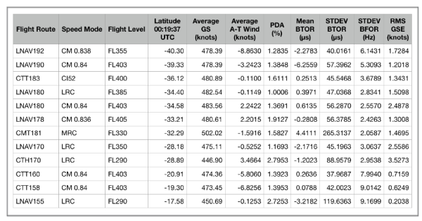
A number of MH370 candidate flight paths have been found over the years by various analysts resulting in Regions of Interest (ROIs) that have either already been searched or have been proposed for a further search. The table below lists some of the ROIs. The table includes some new ROIs which have been found as a result of the current systematic search. Some of the ROIs can be readily dismissed as the standard deviation BTO residual (<47 μs), standard deviation BFO residual (<4.3 Hz) or the calculated PDA (<1.5%) is too high.

Systematic initial bearings from 155°T to 195°T in steps of 1°T were analysed, plus some exotic cases in steps of 0.1°T. All navigation methods were covered: LNAV, CTT, CTH, CMT and CMH, all speed modes: Constant Mach 0.80 to 0.85, LRC 0.7047 to 0.8408, MRC, ECON CI52 and all flight levels: from FL290 to FL430. The fuel endurance was allowed to vary around 00:17:30 UTC and the resulting PDA was noted. The PDA was allowed to vary from the nominal 1.5% and the possibility that the bleed air was shut off for part or all of the time was considered.
In total 1,372 flight paths have been analysed, of which 828 flight paths since the start of this systematic study on 17th February 2019. Start latitudes from 16.0°N to 4.3°S have been covered and the start longitudes were unconstrained. Start times from 18:41:00 UTC to 19:32:00 UTC, but the final major turn had to be completed before the 2nd Arc at 19:41:03 UTC was reached.
Discussion
A more detailed analysis reveals 3 candidate ROIs for further investigation: ROI 1 – LNAV180 CM 0.84 FL403, ROI 2 – LNAV 170 LRC FL350 and ROI3 – CTH170 LRC FL290.
From a pilot’s point of view, a LNAV path on a bearing of 180°T would require setting a final waypoint as the South Pole. This flight path passes close to waypoint BEDAX. The overall fuel endurance and range fits and for a Main Engine Fuel Exhaustion (MEFE) at 00:17:30 UTC, a PDA of 1.37% is calculated (the nominal PDA is 1.5%). The RMS GSE is 2.49, which fits the expected range between 1.0 and 3.0 knots. This flight path ends at 00:19:37 UTC at around 34.5°S near the 7th Arc. This area was originally searched by Go Phoenix but all possible sightings were reexamined and discounted. The search area was widened in later search by Ocean Infinity, but again nothing was found.
An LNAV path on an initial bearing of 170°T starts close to Car Nicobar Airport (VOCX) and passes close to Cocos Island before ending at 00:19:37 UTC at around 28.9°S near the 7th Arc. The overall fuel endurance and range fits and for a MEFE at 00:17:30 UTC, with a calculated PDA of 1.17%. Notably, the Mean BFOR for this flight path is low at -6.87 Hz and is out of the expected range. The area around 28.9°S was searched by Ocean Infinity, but nothing was found.
The CTH path on an initial bearing of 170°T is unlikely as the fuel endurance and range does not fit well. The RMS BTOR is high at 79.6 μs and individual BTOR values are out of normal range. It is also unlikely that a pilot would switch to a True Heading mode. Normal operation is Magnetic Track and this mode is only used for short flight paths, such as during an approach or deviating to avoid bad weather. Switching from Magnetic to True compass mode is only normally done in the region of the north or south poles.

Conclusion
All possible MH370 end points of flight routes in any navigation mode and any speed mode have already been searched, within at least ± 25 NM of the 7th Arc (partially ± 40 NM). This means that MH370 has either been missed in a previous search or recovered from a steep descent of around 15,000 fpm and glided out to an end point outside the previously searched area.
There is only one Region of Interest, where we recommended a further analysis and search at around 34.4 °S near the 7th Arc, following a flight route from close to waypoint BEDAX using the LNAV lateral navigation mode with an ultimate waypoint of the South Pole on a track of 180°T due south, in Long Range Cruise speed mode and at a flight level between FL390 and FL403.
This Region of Interest will be analysed in more depth in the next paper in this series.