Introduction
The civilian radar data for MH370 that became publicly available in April 2018 provides insights as to how MH370 was flown after the transponder was disabled around 17:20:31 UTC. After flying by waypoint IGARI and turning back, the aircraft passed to the north of Kota Bharu Airport, crossed the Malaysian peninsula in a southwest direction, passed to the south of Penang Island, turned to the northwest, and flew over the Malacca Strait. Here, we look more closely at the flight path as it flew towards, around, and away from Penang.
In order better understand the sequence of inputs to the flight control system, we created a simulation using the PMDG 777 model in Microsoft Flight Simulator. In particular, we studied whether the aircraft might have been flown with the pilot providing inputs to the autopilot, and what those inputs might have been.
Although we can calculate the groundspeed from the radar data, the altitude of this portion of the flight is not known. In the simulation, the flight segment near Penang was flown with the assumption of a level flight at FL340 and at Mach 0.84, and with representative meteorological data. These assumptions are consistent with the observed groundspeeds of around 510 knots. Within a reasonable range, the assumptions about altitude, Mach number, and atmospheric conditions do not materially change our observations and conclusions for this portion of the flight.
Simulation
A flight simulation with the autopilot engaged was created in the following manner:
- In the Flight Management Computer (FMC), Penang Airport (WMKP) was set as the destination, and the procedure for an arrival to the ILS04 Runway via the BIDM1A standard terminal arrival route (STAR) was selected. The waypoints for this complete route would be BIDMO- PUKAR-ENDOR-MEKAT-KENDI-CF04-FF04-RW04. The final three waypoints are the final approach course fix, the final approach fix, and the runway threshold, in that order, for an ILS approach to Runway 04.
- Of these waypoints, all are deleted from the route except ENDOR and FF04. VAMPI is added after FF04.
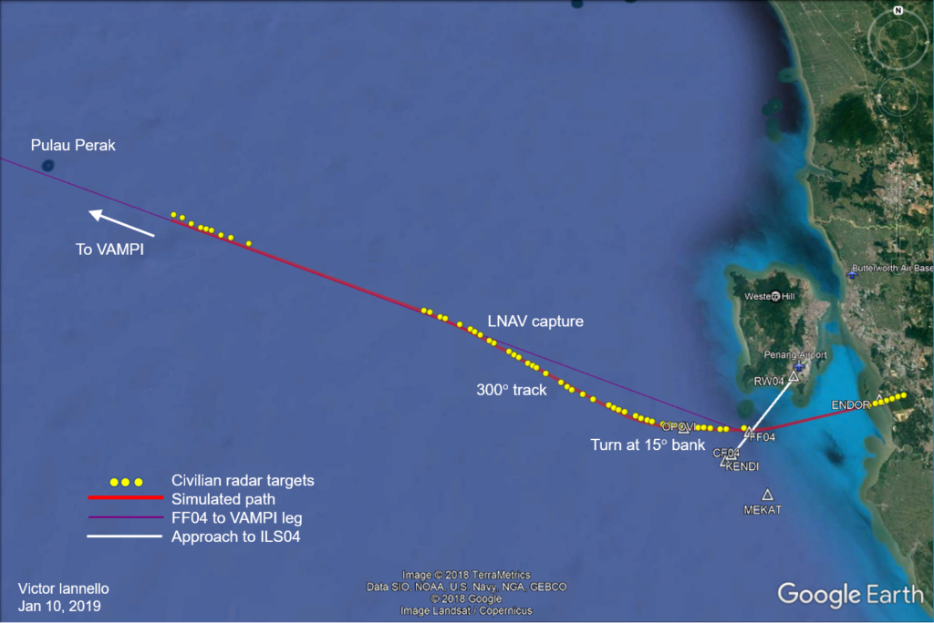
- The aircraft approaches ENDOR with the autopilot engaged and LNAV selected. After passing ENDOR, the aircraft automatically turns towards FF04.
- About 2 NM before FF04, TRK SEL is chosen and the pilot turns the selection knob to steer towards OPOVI using the map in the navigational display (ND) as a guide. The aircraft passes FF04 about 0.4 NM to the right. (If the autopilot had remained in LNAV, the aircraft would not have flown exactly over FF04, as the aircraft would have “cut the corner” as it turned towards VAMPI.)
- After passing near OPOVI, TRK SEL of 300° is dialed with a maximum bank angle of 15°. This initiates a turn to the right at 15°. When the track of 300° is approached, the aircraft automatically rolls out of the turn and maintains this track.
- Once established on a track of 300°, LNAV mode is selected as the next mode.
- At this track angle, the aircraft path converges towards the route leg defined by the waypoints FF04-VAMPI. At about 30 NM from FF04, as the aircraft approaches this leg, the autopilot mode automatically changes from TRK SEL to LNAV, and the route leg is captured.
- The plane proceeds in LNAV mode past Pulau Perak and towards VAMPI on the path defined by FF04-VAMPI.
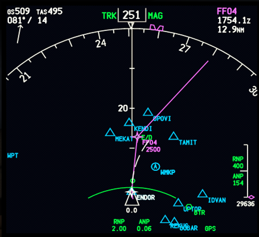
The next figure shows how the waypoints and route legs would appear in the navigation display (ND) in the cockpit after the aircraft had just passed ENDOR and with the route configured as ENDOR-FF04-VAMPI. The route (magenta line) shows the path the aircraft would have followed if the autopilot remained in LNAV mode as the aircraft rounded Penang Island. By comparing the preceding figure with the one below, it is clear that the autopilot changed to a different mode before FF04 and changed back to LNAV mode when the path converged on the LNAV route about 30 NM from FF04.

Observations
There are some interesting observations about this path:
- The agreement between the simulated flight path and the civilian radar data is very good, including the intercept and capture of the route leg to the northwest and towards VAMPI. This suggests that this portion of the flight path was flown in autopilot, although it is nearly impossible to prove that the aircraft was not manually flown.
- The final civilian radar targets fall close to the path defined by FF04-VAMPI. This suggests that VAMPI was selected as a waypoint before reaching FF04, which further implies that there was an intention to fly northwest over the Malacca Strait and to intercept VAMPI even when the aircraft was near Penang. (The distance between FF04 and VAMPI is 166 NM.)
- While in the vicinity of Penang Island, the high measured speed, the implied high altitude, and the selection of VAMPI as a waypoint suggest that there was no true intention to land at Penang Airport.
- The selection of VAMPI as a waypoint while in the vicinity of Penang is consistent with the unverified military radar data that was shown to the MH370 family members at the Lido Hotel in Beijing on March 21, 2014. That radar data shows an aircraft that intercepted airway N571 at VAMPI.
- Although there was no true intention to land at Penang Airport, the flight path may have been chosen to deceive radar operators into believing there was an intention to land.
Possible Deception to Land at Penang
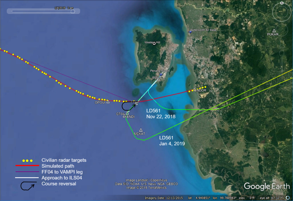
In the figure below, the flight path from MH370 is plotted together with two recent Air Hong Kong flights (both LD561) for the route Ho Chi Minh City to Penang. These flight paths are representative of arrivals to Penang from the northeast. The LD561 paths do not follow the BIDM1A approach route and bear little resemblance to MH370’s path. Likely, the flight crews received vectors from Butterworth Approach to intercept and establish the final approach on the localizer for Runway 04. One of the flights was established at the final approach course fix (CF04) and the other was established only 3 NM from threshold. In the both cases, the intercept with the final approach course required a turn less than 90°. On the other hand, if MH370 had intercepted the localizer, it would have required a turn of about 135°, which would have been a very sharp turn.

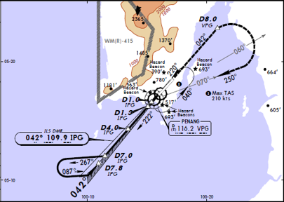
Airline pilot Juanda Ismail noticed that MH370’s crossing of the ILS approach occurs at a similar location and similar intercept angle to what would be flown in the course reversal procedure for ILS04. The procedure is shown in the figure below, and consists of an outbound leg to 7 NM from the threshold of the runway at a track of 222°, a 45° right turn to a track of 267°, a straight leg, a 180° left turn to a track of 87°, a straight leg, followed by a 45° left turn to intercept the inbound approach course on a track of 42°. In the figure above, this same course reversal procedure is represented by the black curve with the arrow.

In the course reversal procedure, the straight leg at 267° is similar to part of the path that MH370 flew. However, in comparing MH370’s path to the course reversal procedure, it is missing the outbound leg, the 180° turn, and the final intercept. As the altitude for capturing to the glide slope is 2500 ft at FF04 (shown as D7.8 IPG in the figure), clearly there was no intention on the part of the pilot to actually perform the procedure and to land. However, it is possible that by flying an element of the course reversal procedure, there was a deliberate attempt to deceive radar operators into believing that MH370 had an intention to land.
With waypoints ENDOR-FF04-VAMPI selected as the route, there is a question as to why the pilot chose to not remain in LNAV mode when approaching FF04, as this would have turned the aircraft and put it on a direct northwest path to VAMPI without the need for pilot intervention. One explanation is that once a turn to the northwest towards VAMPI occurred, it would be clear to the air traffic controllers at Butterworth that there was no intention to land. Entering TRK SEL mode and steering the plane towards OPOVI before tracking back towards the FF04-VAMPI leg delayed that discovery and also positioned the aircraft to initiate the turn further from Butterworth.
It is also noteworthy that once a northwest track was established, the aircraft was tracking to pass through the restricted area designated WMD-412A. This would be expected to draw the attention of the military air traffic controllers at Butterworth. The relationship between the military and civilian ATC is described in this section from the Factual Information released in March 2015:
Provision of approach control service (within lateral limits of Butterworth Control Zone: 5,500 ft. altitude – FL245. (elsewhere 2,500 ft. altitude – FL245). Air traffic to/from the civilian Penang International Airport (PIA) is provided by military ATCOs who have been licensed by the ATI Division develops and establishes the ANS safety standards and performs safety oversight and to ensure the provision of services to civil traffic. The rationale for such an arrangement is based on the military activities at Butterworth Military Airport (BMA) which is in close proximity to PIA, and other military activities carried out over the high seas in danger areas WMD 412A and WMD 413A (permanently established). Furthermore, the final approach segments of both the PIA and the BMA intersect. No major incident has been recorded with the present arrangement/delegation of authority.
Conclusions
- MH370’s flight path near Penang can be replicated with the autopilot engaged.
- The flight path near Penang is consistent with a navigation system that is fully operational.
- It is likely that waypoint VAMPI was entered in flight computers before crossing the approach path to runway ILS04, some 166 NM away.
- The flight path near Penang is consistent with the image of the military radar data in the Malacca Strait that was never officially released.
- It is very unlikely that there was an intention to land at Penang Airport.
- It is possible that the elements of the flight path near Penang were chosen to deceive radar operators into believing that the aircraft had an intention to land.
Acknowledgement
I gratefully acknowledge the helpful comments and suggestions offered by fellow IG members Don Thompson, Richard Godfrey, and Mike Exner.