Archive for 2017

More Analyses of MH370 Data

Predicted location of debris in July 2015 from a crash site of 30S latitude along 7th arc

In the past week, there were two serious technical papers released that discuss evidence surrounding MH370 and with implications on where it may have crashed along the 7th arc.  The two papers demonstrate that there is still significant disagreement about how to interpret some critical technical data.

In the first paper, entitled “The Probable End Point of MH370”, IG member Richard Godfrey concludes that MH370 most likely crashed along the 7th arc at 30S latitude, which is well north of where the seabed was searched.  Richard uses the extensive drifter data from the Global Drifter Program to develop a comprehensive drift model. He organizes and analyzes the drifter data, which includes the position, speed, direction, and water temperature measured by the drifters at 6-hour intervals, and he groups the data by position and calendar month. By introducing an “efficiency factor”, Richard relates the straight-line distance traversed by a drifter over 60 days compared to the total path length calculated from the 6-hour data and integrated over the same 60 days. Richard uses the derived speeds, directions, and efficiency factors to estimate the trajectory of debris that originates from the 7th arc in March. By incorporating the variability of efficiency factor that was experienced by the drifters, Richard calculates and presents the considerable dispersion of debris released from the same starting position along the 7th arc. Richard also relates the predicted temperature history of the debris to the observed barnacle populations on the debris. Richard concludes:

The drift analysis appears to support a probable end point of MH370 around 30°S near the 7th Arc. This fits with a late final major turn south at 19:36 UTC and a flight at the normal cruise speed of 0.84 Mach until fuel exhaustion. There is a good fit to the satellite data and a good fit to a great circle path toward Wilkins Runway (YWKS) as the final waypoint.

The drift analysis also explains the reason why MH370 floating debris originating around 30°S near the 7th Arc could end up in Reunion and South Africa with barnacles via tracks that pass through sea water between 19°C and 25°C and end up in Madagascar, Mozambique and Tanzania without barnacles via tracks that pass through sea water above 25°C.

The second paper, authored by Ian Holland of Australia’s Defense, Science, and Technology Group (DSTG), is entitled “The Use of Burst Frequency Offsets in the Search for MH370”. The paper presents the general methods used to calculate the BFO for reconstructed paths, but the real importance of the paper lies in the conclusions drawn from the BFO sequence at three critical times, which I paraphrase as the following:

The BFO sequence at the log-on at around 18:25Z is consistent with the BFO sequence that was measured for six previous log-ons of the 9M-MRO aircraft after a power down of 35 minutes or more. For MH370, the BFO values starting at 18:25:27Z and ending at 18:28:15Z were 142, 273, 176, 175, 172, 144, and 143 Hz. The decay from 273 Hz to 143 Hz is consistent with the decay in BFO values observed six previous log-ons, while the first value of 142 Hz is not. The author advises us to reject the initial value of 142 Hz because of the lower carrier-to-noise density ratio (C/No) and the non-zero bit error for that data point, which suggests that MH370 was flying at constant speed, track, and altitude during the log-on sequence. It also implies that the statistical equivalence of the first and last values is coincidental. No attempt is made in the paper to reconcile the measured BTO sequence with this interpretation of the BFO sequence (constant speed, track, and altitude).

MH370 should lie close to the 7th arc because the BFO sequence at the final log-on at around 00:19Z is consistent with a steep descent. Two hypothetical cases were considered: A log-on after a power down of several minutes, and a log-on after the SATCOM experienced an outage of communication not related to a loss of power. Considering these two cases, and also accounting for the possible contributions to BFO error caused by the decay in BFO values after a power down and the BFO error caused by drift of the SATCOM’s oscillator, the upper and lower bounds on the descent rate of MH370 were estimated. At 00:19:29Z, the descent rate is bounded between 2,900 and 6,800 fpm. At 00:19:37Z, the descent rate is bounded between 13,800 and 17,600 fpm.

The BFO values at the time of the call attempt at 18:40 suggests the aircraft had already turned to the south. As shown in the figure below, the BFO sequence between 19:41Z and 00:11Z, inclusive, matches a trend line that is consistent with straight and level flight. If this line is extrapolated back to 18:40Z, the author says there is rough agreement with the BFO value at 18:40, which implies that at this time, the plane was already on its straight and level path to the south. The author makes this conclusion despite the approximate 10-Hz discrepancy between the trend line and the BFO value, which is left unexplained.

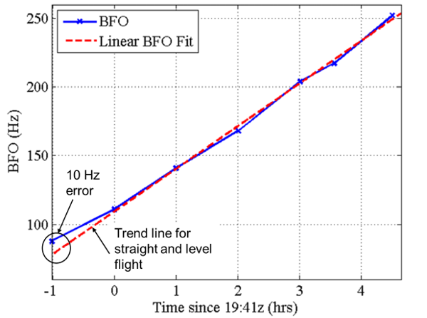
Measured BFO from MH370 flight showing linear trend

The two recent papers demonstrate two sensible but different interpretations of the same set of data. If we are to accept the conclusions in Ian Holland’s paper, then the range of latitudes of the underwater search area was properly defined, and the aircraft should have been found close to the 7th arc. Why the aircraft was not found remains unexplained. On the other hand, Richard Godfrey, both in his recent paper and in a previous paper he co-authored with me, challenges the assertion that the BFO at 18:40Z unequivocally demonstrates that MH370 was flying south at that time.

As we attempt to explain why the underwater search has failed, the two papers demonstrate the importance of challenging some long-held assumptions. The difference in interpretations of the two authors is yet another demonstration of why it is imperative that the authorities release all the available information related to this case.

Update on 2/18/17: The deviation from the trend line was corrected to 10 Hz.

Posted in Aviation | 206 Comments »

Singapore Radar and MH370

A G550-EL/W-2085, an Israeli airborne radar system operated by the Republic of Singapore Air Force

Investigation officials have stated that the last radar capture of MH370 was a target in the Malacca Strait about 10 NM past waypoint MEKAR on airway N571, recorded at 18:22:12 UTC. Unfortunately, this last capture occurred before MH370 made its final turn to the south. The location and timing of this turn has been the subject of much debate because it has a significant impact on where MH370 crossed the 7th arc, and therefore it is important in defining the underwater search area. If we assume the aircraft was flying level after the log-on at 18:25 UTC, then the BFO data tells us the turn to the south must have occurred no later than 18:40 UTC. However, if we are open to the possibility that MH370 was descending at 18:40 UTC, then the turn to the south might have occurred after 18:40 UTC.

In the ATSB report released on June 26, 2014, we learned that there might have been other radar sources in the area that could give us hints about the path of the plane. There is the statement “The aircraft passed close to a NW point at 1912”. However, the report gives no indication of where that radar source was located, and whether there was a definitive capture. Because any radar captures after 18:22:12 UTC would provide important clues about the final path, there is interest in learning more about this “NW point”.

Researcher Dr. Niels Tas asked the ATSB about the NW point, and received the following reply: “The NW point at 1912 was an assumed theoretical location at 8° 35.719’N, 92° 35.145’E initially chosen to provide clearance from the known radar sources (mainly Singapore). A line from IGREX to the 1912 point was used as an upper bound for the airplane performance work after loss of radar contact (the min flight distance would be turning south right after loss of radar). This point did not affect the Doppler analysis, just the fuel burn, which affected the range measurements. Analysis had included using the upper bound (IGREX/1912 point) and the lower bound (direct from the 1822 point)…”

This response provides us with some clues about the radar source. First, we have a precise position for the NW point, which puts it in the Indian Ocean to the west of the Nicobar Islands, and about 15 NM to the right of a plane traveling along airway N571 between waypoints IGOGU and LAGOG. Second, we learn that the radar source is an asset of Singapore. Because Singapore is about 800 NM from the NW point, it is impossible that the radar installation is land-based in Singapore. If not land-based, it is mobile, and possibly airborne.

It is well-known that Singapore has significant airborne radar capabilities. In 2012, Singapore announced that an additional four Airborne Early Warning and Control (AEW&C) aircraft were operational, to complement the first it has fielded in 2009. These G550-EL/W-2085 aircraft were purchased from Israel, and are Gulfstream 550s fitted with phased-array radar. The reported range is 200 NM.

I asked the ATSB for more information about the NW point. Because the radar source is a military asset, much of the information is protected. However, I was able to learn that the NW point was shared by a member of the Joint Investigation Team (JIT), which consists of personnel from Malaysia, Australia, China, the UK, the US, and France. The NW point is not an actual radar capture, but was used in early path models as the latest time and position for the turn to the south. Basically, if the turn had occurred to the northwest of this point, it would have been detected by the radar source. I also learned that this radar source had no coverage of the Andaman and Nicobar Islands. Finally, I learned that this radar source had no coverage of any of the high probability paths predicted by the ASTB.

I was interested in determining where the airborne radar might have been, and whether the lack of radar captures might help us exclude certain paths that would fall within its range. In particular, I was interested to know whether the lack of detection might preclude a path between Car Nicobar and McMurdo Station. I proceeded with the following assumptions:

  • There were no radar captures after 18:22:12 UTC.
  • The range of the airborne radar was 200 NM.
  • The NW point is at the limit of the range of the airborne radar.
  • The airborne radar was in a tight holding pattern and never was very far from a fixed location.
  • All of the Andaman and Nicobar Islands were beyond the range of the airborne radar.
  • A path reconstructed with a turn at 18:40 UTC (the latest turn considered by the ATSB) would be beyond the range of the airborne radar.

The results from the analysis are shown in the map below. A circle with a radius of 200 NM defines all possible points at the range limits of the radar. Therefore, the position of the airborne radar would be somewhere along this circle. Possible radar positions that satisfy the criteria listed above fall on an arc between the red and green stars. Points to the northeast of the red star would have allowed radar coverage of portions of the Andaman Islands. Point to the southwest of the green point would have allowed radar coverage of some of the high probability paths reconstructed by the ATSB.

Range of possible positions of the Singapore airborne radar

If the radar source was located at the orange star or to the south, MH370 would have been seen if it followed a path between Car Nicobar and McMurdo Station. However, radar positions along the arc to the north of the orange star would not have seen MH370 if it traveled along this path.

It’s therefore possible that if an airborne radar source was circling about a fixed location somewhere along the white arc between the orange and red stars, it would not have seen MH370 if it flew towards McMurdo Station.

But here’s a related question: Why was Singapore possibly operating an AEW&C asset in the Indian Ocean to the west of the Andamans and 800 NM from Singapore?

Posted in Aviation | 40 Comments »

Why We Need Data Withheld by Malaysia

Radar data shown to MH370 families but never released.

It’s now almost three years since the disappearance of MH370. After an exhaustive underwater search in the Southern Indian Ocean (SIO) of around 120,000 square kilometers, we are still unable to locate the fuselage of the aircraft. The main evidence we have to locate the wreckage are the communication signals between the aircraft and a ground station in Perth, relayed by an Inmarsat satellite in a geosynchronous orbit above the Earth. From these signals, assuming they have not been manipulated, we do know that MH370 turned south and ended its flight along an arc in the SIO we now call the “7th arc”. We have also recovered debris from the crash that has washed up on the shores of several countries in Eastern Africa. Although the satellite data and the timing and location of the recovered debris support the theory that aircraft terminated in the SIO, they do not provide enough precision to locate the aircraft.

In order to estimate where MH370 lies in the SIO, a number of us, including the official investigative team and we in the MH370 Independent Group (IG), have used mathematical models to reconstruct paths that replicate how MH370 might have been flown. These models incorporate a number of assumptions, some of which we can be fairly certain are correct, and others that we are less certain about. For instance, assumptions about the performance of the aircraft, including minimum and maximum speeds, fuel consumption, and autopilot behavior, are all fairly well known. Other assumptions about the “complexity” of the path are less known. There are some that maintain that the simplest of reconstructed paths, i.e., paths with the fewest numbers of changes in speed, direction, and altitude, are the most likely. In fact, the current underwater search area is derived from this assumption. But with the failure to find the wreckage, it is time to re-evaluate this assumption. After all, the aircraft did not follow a random path. Rather, the aircraft likely was actively flown by the pilot (or pilots) at least until it made the final turn towards to the SIO. If the diversion was intentional, then there was a reason for the pilot choosing to fly along the particular path. As a result, models that reconstruct the path using a series of random events are likely to fail because they do not account for the motivation and intentions of the pilot.

If we are going to consider complicated paths that might include turns, holding patterns, changes in speed, and descents, the search area grows to an unmanageable size. We therefore have to introduce other assumptions and/or constraints to limit the size to something searchable.

Fellow IG member Richard Godfrey and I recently wrote a paper in which we predict a crash site for MH370 using certain data found on Captain Zaharie Shah’s home simulator. The simulator data include six position coordinates from a flight the Captain created using Microsoft Flight Simulator. The positions first show the aircraft on the runway at Kuala Lumpur International Airport, and then progressively airborne in the Malacca Strait, the Andaman Sea, and the SIO. The simulation ends with the aircraft running out of fuel in the SIO. Recognizing that the positions in the Andaman Sea and the SIO align with an ice runway at McMurdo Station, Antarctica, Richard and I hypothesize that the Captain used this same final waypoint when he programmed the flight computers of MH370. By combining this final waypoint with the available satellite data, we predict a terminus on the 7th arc well north of the current search. This theory also predicts that the aircraft entered a holding pattern near Car Nicobar Airport in the Andaman Sea before turning towards the SIO.

The failure of the underwater search and the modeling work of Richard and me shows the importance of using all the available evidence in defining possible crash sites. However, much of the evidence has never been made public. For instance, the data obtained from the Captain’s computer was from a secret Royal Malaysia Police (RMP) report that was never officially released. We are only aware of it because the report was leaked to French media organizations.

Australian reporter Marnie O’Neill recently asked fellow IG member Don Thompson and me to make a list of what important evidence was being withheld, and she used this as the basis of a story for news.com.au. Here are some examples of how Malaysia is showing that it is not fully committed to the finding MH370:

Inadequate Response to Disappearance

  • After the disappearance, there were only two attempts to reach MH370 using SATCOM voice (18:40 and 23:14 UTC).
  • There was no attempted military air intercepts as MH370 turned back and flew across the Malaysian peninsula despite plane detection by military radar in real time.
  • There was a delay of four hours after the disappearance before search and rescue (SAR) efforts began.
  • There was a delay of four days (March 12, 2014) before search shifted from South China Sea to Indian Ocean, despite having radar data.

Denied, Omitted, or Ignored Data

  1. Radar captures of MH370 in the Malacca Strait were shown to the victims’ families in Beijing on March 21, 2014, but radar captures between 18:02 and 18:22 UTC were never shared with the ATSB. (See figure above.)
  2. The partial data set of raw radar data made available to the ATSB was never shared publicly.
  3. The ATSB report released in June 2014 includes statements about a radar capture of MH370 at 19:12 UTC in the Andaman Sea. Later, the ATSB acknowledged the data to be from Singapore radar, and considering the distance from Singapore, likely was from an aircraft with radar capability operating in the Malacca Strait or Andaman Sea. No mention of this data is included in the Factual Information released in March 2015, yet if this data exists, it would place the terminus in the SIO much further north than where MH370 was searched.
  4. The existence of telephone records indicating a connection of the First Officer’s cell phone to a tower on Penang Island was first denied by Malaysia and not included in the Factual Information report released on March 2015. The secret RMP report has detailed information about this connection.
  5. The simulator data recovered from the Captain’s computer suggest a simulated flight with points in the Andaman Sea and the SIO. Malaysia first denied the existence of this data and did not include the data in the Factual Information report released in March 2015. The secret RMP report included some information about the simulator data, but the details about how the data was extracted and analyzed are unknown.
  6. The secret RMP report documents WeChat activity on the Captain’s cell phone while MH370 was lined up on the runway, only one minute before takeoff. The details of this activity are not presented in the RMP report. No mention of this data was included in the Factual Information report released on March 2015 despite its extreme relevance.
  7. Malaysian authorities have shown no timeliness in retrieving possible MH370 debris recovered from the shores of Eastern Africa.

As Don said in the article, “My own ‘hot button’ is that military long-range air defence surveillance data from assets operated at seven, possibly even eight, sites across four nations is absent from the data set available to ATSB.”  Don explains that “[t]hose [sites], all within range of the flight path MH370 is believed to have taken, are located at Lhokseumawe, Sabang/Pulau We and Sibolga in Indonesia; Car Nicobar and Port Blair in the Indian Andaman Islands; Khok Muang and Phuket in Thailand; and Western Hill, Penang, Malaysia. Any one of them, or all collectively, could provide the vital clues to the plane’s whereabouts.”

If we have any hope of re-starting the search for MH370, we need all the available data so that we can properly constrain the models we use to predict the terminus. The time for Malaysia to release all it has is long overdue.

Posted in Aviation | 91 Comments »