Civilian radar data after transponder was disabled. (Click to enlarge.)
We know that MH370 was captured by civilian and military radar sites before and after the transponder was disabled at 17:21 UTC. However, Malaysian authorities have chosen to release these data sets only as low resolution images that have imprecise position information with few timestamps. The DSTG did choose to publish in its Bayesian analysis the speed and track data that was derived from radar data that was provided to them by Malaysia. However, the DSTG presented the speed and track data after applying a Kalman filter to remove noise. It’s unknown whether that Kalman filter produced artefacts in the graphical presentation of that data.
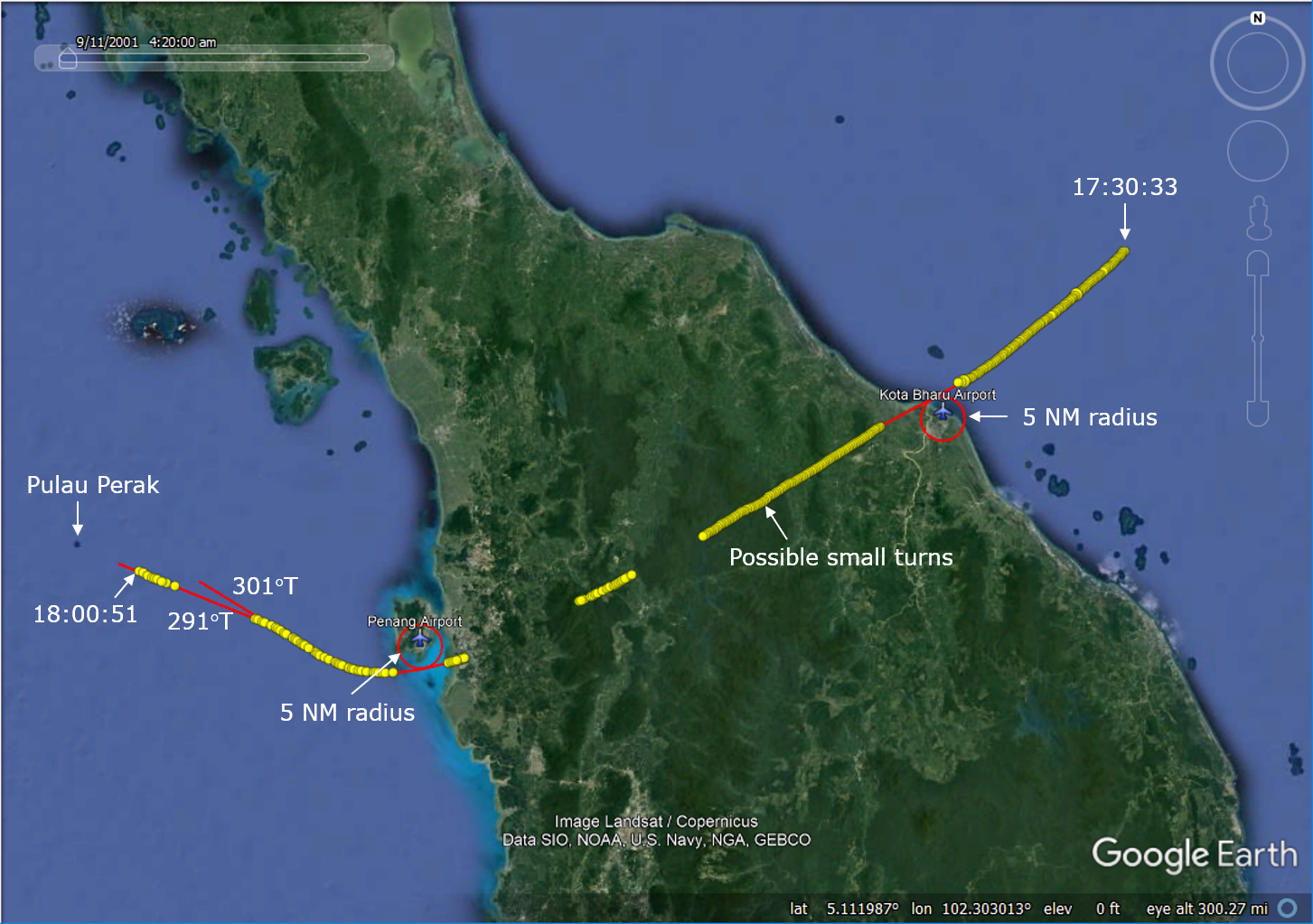
We now have what we believe are the data sets for the primary surveillance radar (PSR) and secondary surveillance radar (SSR) from Malaysian civilian radar assets. The PSR data is of particular significance because it provides additional insight about how MH370 was flown after the transponder was disabled at 17:21 UTC. The data was publicly released by fellow IG member Mike Exner. The military radar data remains unavailable.
The data begins at 17:30:33 when the civilian radar installation at Kota Bharu Airport (WMKC) detected MH370 traveling back towards the Malay peninsula about 58 NM from shore. The last radar target was captured by the civilian radar installation at Butterworth Airfield (WMKB) after MH370 had passed to the south of Penang Island and was tracking northwest up the Malacca Strait towards Pulau Perak.
Some initial observations about the data:
- The PSR data is similar to the civilian radar data that was graphically presented in the Factual Information (FI) from March 2015. However, while the last civilian radar capture in the FI was at 17:51:47, the new data set has captures until 18:00:51.
- The path derived from the Kota Bharu radar data is not straight. More analysis is required to determine if this waviness indicates that there were pilot inputs from manual flying, pilot inputs to the selected heading with autopilot engaged, or inaccuracies of the radar data.
- The path was tangent to a 5 NM radius for both Kota Bharu and Penang Airports. This may indicate that these airports might have been displayed as fixes in the navigational display (ND) with a radius of 5 NM and used as navigational references.
- After passing to the south of Penang Island, the plane first tracked towards 301ºT, and then changed to 291ºT, which aligned with Pulau Perak and roughly towards VAMPI.
- The groundspeed data as derived from the radar data is noisy, reflecting uncertainty in the value of the timestamp as well as the range and azimuth for each capture. In light of the uncertainty, the average speed was calculated for five of the six segments of radar captures, and shown by the red line in the figure below. (The time interval of the shortest segment was only 24 s, and deemed to short to calculate the speed with a useful level of precision.) The average speed for the second and third segments are 527 knots and 532 knots, respectively, which suggests the plane was flying close to Mmo=0.87. For instance, with a tailwind of 12 knots and a temperature offset of ISA+10.3K, a groundspeed of 527 knots converts to M0.87. At the Mmo/Vmo crossover altitude of 30,500 ft, a groundspeed of 532 knots converts to M0.86. This suggests that after the aircraft flew past Kota Bharu, it was at the upper end of its operating speed range, and possibly at times beyond it.

Calculated groundspeed as derived from the civilian radar data. (Click to enlarge.)
I know that independent investigators that contribute here and elsewhere will continue to analyze the data to better understand how MH370 was flown before it completely disappeared from all radar sites.
Update on April 12, 2018: The plot of groundspeed was updated by removing the trend lines and replacing them with average speeds over segments. In light of the noise on the speed calculations, this is more appropriate. The estimated peak groundspeed reduced from 545 knots to 532 knots. The corresponding text in (5) was also updated to reflect this change.
Update 2 on April 12, 2018: Here is an Excel file for those wishing to see the basis for my calculations. Please let me know if corrections are required.
@Nemo
@David
Apologies, carried over from previous post.
A nefarious pilot might have wanted the cockpit door video system back up and running, or possibly electric power restored to the door lock mechanism?
I seem to remember that the video security system is powered from the LH AC Bus, and controlled through the IFE switch. He may have wanted to see what was going on the other side of the door after repressurizing the cabin. He could at intervals, briefly power up the video system via the IFE switch to monitor the cabin, but only briefly because the SATCOM was also up and running.
The door lock fails open when power is removed, and but can be locked manually. He may have wanted to restore power to the door lock for some reason.
The IFE can be disabled from the switch on the overhead panel, ie it can be disabled without having to resort to disabling the SATCOM. The ACARS can be selected off from the cockpit, which prompts the question isolate the LH AC Bus in the first place?
I think he isolated the AC Bus primarily to disable the SATCOM until he was out of primary radar range, firstly to prevent any incoming telephone calls from being acknowledged by the SDU. It would present MAS with a dead line as opposed to an unanswered call, which would suggest the plane had gone down when the transponder was lost. MAS would not then be prompted to ask the military to start a radar search. One hour later, the nefarious pilot deemed himself to be safely beyond Malaysian primary radar reach, and regarded it safe to reconnect the LH AC Bus.
@Victor
Looks like potentially important data, thank you and ALSM for bringing the data forward.
Questions:
(1) Could the speed lead to incipient structural damage (eg; pre-dispose the flaperon and outer surfaces for later falling off)?
(2) Does the high speed indicate descent from FL380-FL430?
(3) If so, does that sound like zoom climb after IGARI accounting for the small radius of the turn at IGARI?
(4) Overall I wonder the whole flight was heading settings vs. waypoints
@Ge Rijn
PS- Correction my prior response last page “soul” searching.
18:00:51 ??? If FI did not mention could it be another plane?
@TBill
I did understand you I think. The whole point is this all is collateral information. Just like this updated radar-data. All nice and well but we already know the plane was flown deliberately and precise towards Penang and after. There’s no other sensible explanation.
The exact details don’t matter that much anymore now.
I feel it as kind of distraction on what is happening right now.
I think @ALSM and others could do better work if also concentrating on the short search time left and start doubting there search-width assumptions now there is still time.
And ofcourse starting to take the ‘Blue Panel’ and associated debris field more serious.
@ Tbill, there is an obscure waypoint “ENDOR” that would give about the right distance if OPOVI was the next one.
@Victor,
Good to have some more detail on the radar trace. Interesting to note the gentle turn at Penang, to me it looks like at least a 20nm radius.
So what autopilot mode was used to make this turn? Turns in LNAV or Heading mode would produce smaller radii. I think it looks more like an ‘autopilot off’ flight, and the aircraft is just meandering. What does everyone else think?
@TBill
According the best and latest drift-analysis (CSIRO/Griffin, Pattiarachi, Godfrey) all latitudes north of ~29S don’t fit the possible time-frames any more and/or coverage both of the Pemba-piece and Mosselbay-piece at those latitudes are impossible given the latitudes and time-frames.
Even ~30S is allready problematic considering the flaperon beaching imo.
Only including a ~140 days delay in a gyre would make this possible as far as I can see. Possible but in general unlikely.
The drift along the Broken Ridge trenches was to the east after 8-3-2014 and weeks beyond that time.
The ‘Blue Panel’ and 13 other spotted pieces were around 32.4S/97.80E at 28-3-2014.
A simple reverse drift indication using the CSIRO KMZ-files tells you those pieces could well have drifted from closer to the 7th arc.
I see 97.15′ as the minimal width in this region.
We’ll see. I truly support OI will searched Victor’s debris-area.
This can not be ignored anyway.
@Victor, thanks for this interesting article. I wasn’t aware that the plane might’ve been flown faster than the normal envelope protection would allow.I remember that there have been early rumors after the plane vanished, that it had been flown at “break neck speed”, but later we were informed that these allegations were not correct.
@Ge Rijn, analysing the primary radar data after the turnaround at IGARI might seem irrelevant to you. For others it’s not. As a propagator of the rogue-pilot scenario I wonder why the pilot (most likely ZS) might’ve pushed the envelope to such a degree.
Ge Rijn: Sorry you don’t understand the importance of the new data and possible implications for the SC search area.
The importance of the new data is (at least) two fold. For the first time, we have the level of detail needed to see that the plane was probably hand flown for most if not all of the time from 17:21 to 18:01. Victor, Andrew and I have discussed this, and have slightly different interpretations. I’ll let them elaborate on their views. But I think we all agree that it is likely the plane was hand flown towards Penang. Both the high speed build up and somewhat “wobbly path” are more consistent with a hand flown path (though not certain). At some point around the time of the Penang turn, the AP may have been set to TRK or HDG HLD, and then adjusted from ~301 to 292 circa 17:57 UTC. Hard to tell when the NAV mode change took place.
I think the new data also removes any doubt about the possibility of an attempt to land at Penang.
The speed build up also has implications for fuel consumption models, and therefore endurance, and possibly further evidence for a POI further NE than the original search further SW. Bobby has already made a few calculations on that subject.
A speed of ~mach 0.90 has a number of implications for the understanding of what was happening. Such a high speed is not consistent with any SOP for an emergency. It may also give more weight to early reports that there was a descent along the path to Penang.
@ALSM, thanks for the very illuminating comment. Very interesting…
this make me even more suspicious of the fly back over Malaysia theory, the fly back data looks too inconsistent. perhaps MH370 never turned back.
@Sabine: More thought needs to put into the interpretation of the speed data, which was derived from the (time, range, and azimuth) radar data. If MH370 did actually fly faster than Mmo or Vmo, that could mean that the envelope protections were deliberately disabled. The easiest way I know to do that would be to disconnect the primary flight computers (PCFs) with the overhead switch, which would force the flight control mode to degrade from NORMAL to DIRECT. That seems like a drastic action to take.
@TBill: To answer your questions:
1) Considering that the plane continued to fly for many hours, if there was structural damage, it would be minimum.
2) The high speeds might be indicative of a descent, but that is not certain.
3) I don’t know what the radius of the turn at IGARI was. We have no data. We are guessing based on a fuzzy image which might have been fabricated to serve as a replacement for missing data.
4) We can’t rule out the possibility that none of the flight was flown with autopilot engaged.
@Andrew: There is an interesting video that might have been taken in a Level D simulator for some B777 version. With A/P engaged at FL340, A/T was disengaged and the throttles advanced to 100%. There was only enough thrust to reach M0.884, but then a V/S descent was initiated, and the speed reached M0.897 at which time overspeed alarms began. (The claim in the video is that Mmo=0.897.) During the descent, the speed continued to increase until [M0.920], and then the pitch increased and the thrust reduced to idle to reduce speed.
What’s interesting to me is that flight envelope protection allowed speeds higher than Mmo. Is there validity to this video?
@All,
So now we have a flight back across the Peninsula that is erratic. A wobbling track, unknown/changing altitude and now speed above Mmo. To me this is indicative of an aircraft that has suffered considerable damage and there’s no one in control.
Re the drift analysis- I think we have to assume pieces were washing up long before they were found(1 or 2 months)Therefore, points further north become more acceptable. Remember, no one was searching those beaches when debris was actually washing up.
I appologize to others who are involved in a more technical disscusion, but I have to ask one simple question. With such a high speed what would be the maximum range of the aircraft along the seveth arc? If the plane flew in the constant direction after FMT, then it has to be more south in order to match BTO. Yet, fuel economy would decrease, which might not allow long range to match BTO. Is there any discrepancy here or not? Thank you.
@Tim wrote, “To me this is indicative of an aircraft that has suffered considerable damage and there’s no one in control.”
That statement is an oxymoron! For the aircraft to be flown in excess of Vmo speeds at FL350~ requires someone to be “in control”, and considerable damage doesn’t even fit the same flight envelope description.
Tim said: To me this is indicative of an aircraft that has suffered considerable damage and there’s no one in control.
Funny, I came to the exact opposite conclusion. Despite the high speeds, the flight looks quite controlled.
Barry Carlson &Tim: I agree w/ Barry. The speed is only consistent with a deliberate (extreme) act by the PF (whoever it was). I suspect it went something like this:
Just past IGARI, turn off the transponder. Pull the throttles back and pull up to trade airspeed for altitude. Start a hard left turn during the climb. Roll out to take a look. Continue turn and round out on a heading toward Penang, start a descent and add power back until sometime circa 17:45-17:50 where the speed reached 565 kts. May have had to disable protection as suggested by Victor to get to .90. This was no accident.
@Barry C,
The sort of damage I’m considering is not so much airframe, but electrical and pitot static supplies. Enough to render the autopilot into Direct mode. So there is no speed envelope protection.
Tim: Try to reconcile that assumption with the fact that plane continued to fly for 7 hours.
@ALSM, VI, Andrew: I’ll be fascinated to see your respective analyses of this over coming days.
To an amateur, it’s certainly consistent with 1) getting into the Andaman Sea as quickly as humanly possible, certainly consistent with avoiding intercept, 2) by going directly over two civilian airports, making it plausible that landing was intended, and 3) if flying beyond envelope protection, someone knew what they were doing. Doubt that a 9/11 half-term flight school hijacker would pull this off.
@ALSM,
Consider this, the damage is mainly electrical, the aircraft has been trimmed for cruise. Even with no autopilot, and in secondary mode it will fly on until fuel exhaustion.
@Victor. “The easiest way I know to do that would be to disconnect the primary flight computers (PCFs) with the overhead switch, which would force the flight control mode to degrade from NORMAL to DIRECT. That seems like a drastic action to take.”
I think turning off all generators is back in the mix, adding transponder off.
@David: Yes, by switching the left and right tie breakers to isolation and switching the left and right IDGs and the left and right backup generators all to off, the transfer busses would be unpowered, the pitot heaters would in turn be unpowered, and the flight control mode would degrade to SECONDARY. I didn’t view that as the easiest way to defeat the envelope protection, but it’s possible.
But I’d also like to be sure that Mmo and/or Vmo cannot be exceeded in NORMAL flight control mode. It might be possible that with the A/T disengaged and the A/P engaged, it’s possible to apply full thrust, perhaps combined with a descent, and exceed Mmo and/or Vmo by some margin before envelope protection reduces speed. That’s what the video indicates, and that’s also the behavior of the FSX/PMDG777 model. It would be helpful to find any documentation on this matter.
@Marijan, you asked a question re: the fuel range of the plane. If I understand you correctly you want to know if flying the plane at such high speed after the turnaround near IGARI means that there would have been more fuel used up and consequently less fuel left than previously thought for the final run into the SIO. That might indeed be so. In this case the plane might’ve ended up further north on the 7th Arc than the various latest calculations suggested.
@Victor. Irregular I know but I repeat a post from the JW site by @Gysbreght:
“@Sunken Deal: “Can anyone make sense of this supposed new data that VI released on his blog today, via ALSM?”
They finally understand that the airplane was not flown on autopilot. Perhaps some time they will understand that the ‘noise’ in the calculated speeds is due to rounding errors, for instance the primary radar UTC rounded to full seconds.”
@Victor, ALSM. Thank you very much indeed for sharing this.
1. Could you please provide a little clarification on the method used to derive spot speeds in the second figure?
2. Not knowing anything about PSR logic: is the slant range data in the csv is actually “raw” – or does the radar logic itself make some sort of “assumption” on altitude, from elevation or otherwise, to obtain a horizontal range estimate?
3. For the derivation of lat/long presented in the GE figure, what altitude assumption is made?
@David: That’s a typical, snide, half-informed comment from him. The data is available to him to produce something of value if he chooses.
@ALSM Your second figure with the derived spot speeds in blue clearly shows multiple secondary “series” indicative of some sort of quantisation – whether due to the repetitive rounding errors on timestamps or otherwise. Can we extract a single “series” and if so, what does it tell us about speed?
You say: “The path derived from the Kota Bharu radar data is not straight. More analysis is required to determine if this waviness indicates that there were pilot inputs from manual flying, pilot inputs to the selected heading with autopilot engaged, or inaccuracies of the radar data.”
When you imagine the other alternative: that the autopilot was actually disconnected; a whole new world opens to you.
If you don’t choose to consider what heavy jet pilots do in Smoke Fire Fumes sim scenarios, and what the Captain did in UPS6, then you are missing what may well have happened with MH370.
Why would anyone want to fly faster than Mmo anyway. It doesn’t make sense. There would be no reason too. After all, it’s only a small percentage faster. Perhaps it will be this fact that points to this just being an accident.
Trying to explain this away as Pijack is getting ridiculously convoluted and complicated.
Paul Smithson:
I derived speeds as follows:
1. Convert all the raw slant range and az records to target Lat/Lon values. I did it using some basic algebra and trig math and simplifying assumptions. Victor did it using more elegant math and earth models. The 2 methods produced similar results, but Victor’s mythology is superior, so we are going with that.
2. As noted, the raw data is noisy, so I used an 11 point moving average to filter the results. That method provides a better understanding of the trends. Although the 4 second data is noisy, the averaged data makes the general speed trend very clear.
3. I then plot the averaged speed in Excel and add a second moving average filter (trend line) to smooth out the graphics.
It should be noted that the noise is not indicative of actual aircraft motion. 4 seconds is a very short sample period, so a very noisy delta position is to be expected over 4 seconds. But positions differenced between, say, 60 or 120 seconds yield much smother results. Or a moving average over such a period.
There are several factors affecting the accuracy. One is the accuracy of the radar range, probably OTOO 1%. Another is the accuracy of the azimuth, probably OTOO 1 degree. Additionally, the time stamps appear to be sync’ed to the antenna north position, not the target position. That’s a guess, but I hope to get that answered soon.
I have .kmz files available if anyone wants to bypass the math and go to the good stuff.
Paul Smithson: Not sure which figure you are referring to. Please provide the details.
@Victor. “The easiest way I know to do that would be to disconnect the primary flight computers (PCFs) with the overhead switch, which would force the flight control mode to degrade from NORMAL to DIRECT. That seems like a drastic action to take.”
Victor- Let’s get you out of your B777 “piloting” comfort zone. let’s say the goal is to wipe the evidence. You’ve already visited the MEC Bay to take out the circuit breakers for the flight data recorders. Now the goal is to wipe the memory chips on the Flight Computers, or at least do not add any incriminating data.
Now (speculating) if and when we find the aircraft, we’ll never know how it got there. I’ve been a bit influenced by the recent Aussie radio interview posted by @ventus45, which indicated that if the data recorder is *not* found, the other cockpit electronics can “data-mined” as a substitute. Not so fast, perhaps the pilot was thinking.
@victor
@ALSM,
Any idea why the last KL SSR data in your ‘data set’ is at 1706z and not 1720z?
@Rob
Re: ‘I seem to remember that the video security system is powered from the LH AC Bus, and controlled through the IFE switch.‘
It’s not. This was discussed in some detail last July. On the MAS B777-200s power to the Cockpit Door Surveillance System camera is controlled via a switch separate to the IFE controls that is mounted in the center cockpit pedestal. The system is powered from the aircraft’s 28V DC RBUS.
@Victor
RE: “But I’d also like to be sure that Mmo and/or Vmo cannot be exceeded in NORMAL flight control mode. It might be possible that with the A/T disengaged and the A/P engaged, it’s possible to apply full thrust, perhaps combined with a descent, and exceed Mmo and/or Vmo by some margin before envelope protection reduces speed.”
The simulator in the video is a B777-300ER (B-16701), operated by EVA Airways in Taiwan. The -300ER’s MMO (M0.89) is higher than that of the -200ER (M0.87). The autopilot overspeed protection operates as depicted in the video. The overspeed warning occurred at M0.897 (1:00) and the aircraft kept accelerating until it reached M0.92 (1:29), at which point the autopilot overspeed protection kicked in and raised the nose.
I have not seen any published numbers, but anecdotally the overspeed protection in the -200 series aircraft works the same as the -300, albeit at a slightly lower Mach no. The overspeed warning occurs at about 0.877 and the autopilot overspeed protection kicks in at about M0.90. To answer your question: It is possible to exceed MMO by a small margin in NORMAL mode with the autopilot engaged.
@airlandseaman,
The Range listed in your table cannot be the slant range between the radar and the aircraft because the very first entry is only 0.83 NM (I am using your XLSX file) . The altitude at FL350 is 5.76 NM, so a slant range of 0.83 NM is clearly wrong.
If not slant range, what is it?
DrB:
The KL 0.83 NM range is correct. That range was taken as the plane took off, at the end of the runway.
@airlandseaman,
I think I understand it now. That first bit of data was from KL, so the aircraft was taking off and climbing at the time. I mistakenly thought the data started at Bota Bharu. Never mind.
@Andrew: Based on your anecdotal evidence, I believe it is possible that the groundspeed of 545 knots was attained with the A/P engaged and the A/T disengaged, possibly while descending. I hadn’t thought it was possible to exceed Mmo with the A/P engaged until I found the video and tried a similar experiment with the FSX/PMDG777 model. Your anecdotal evidence is consistent with these simulations. That makes me doubt that drastic steps were taken to circumvent the flight envelope protection.
@James Nixon said: When you imagine the other alternative: that the autopilot was actually disconnected; a whole new world opens to you.
If I recall your theory correctly, you believe the flight path was consistent with the autopilot disengaged and weather inducing turns while in NORMAL flight control mode. As we have discussed before, I really don’t think that meteorological conditions can explain straight segments connected by large turns, nor do I think that a B777 would fly for hours in NORMAL control mode. The inherent stability from the dihedral effect is easily overcome by asymmetrical effects such as rudder out-of-trim, thrust imbalance, and turbulence.
@James Nixon
RE: “If you don’t choose to consider what heavy jet pilots do in Smoke Fire Fumes sim scenarios, and what the Captain did in UPS6, then you are missing what may well have happened with MH370.”
Would you care to elaborate??
@Warren Platts
@TBill
ENDOR doesn’t come up often but it isn’t exactly obscure; it’s part of the Standard Terminal Arrivals (STARS) approach route to Penang’s RWY 04 for arrivals from the north-east known as BIDMO 1A (BIDMO-PUKAR-ENDOR-MEKAT-KENDI).
@airlandseaman
Mike, if you don’t mind sharing the .kmz file (or the lat/lon data used to construct it) that would be very much appreciated.
@Victor
RE: “I believe it is possible that the groundspeed of 545 knots was attained with the A/P engaged and the A/T disengaged, possibly while descending.”
That does seem possible. Given the light winds, I think it’s likely the pilot would seek to increase speed to the highest possible TAS, assuming the intention was to cross the Malay peninsular and ‘escape’ as quickly as possible. That would require a descent to an altitude near the MMO/VMO crossover altitude (FL305), as previously discussed. Perhaps the pilot disengaged the A/T, set maximum thrust and conducted a shallow descent (500 ft/min??) to the lower level. The descent would certainly help the aircraft to accelerate to slightly beyond MMO. The engines would also produce a bit more thrust at the lower level, which would help to maintain the high speed once the aircraft resumed level flight.
However, none of that explains why the radar path between Kota Bharu and Penang is so much more ‘wobbly’ than the path after Penang.
@ALSM
I see the important relevance of this data mostly as further proof/indication the flight was well planned and flown by a very skilled pilot. He probably wanted to pass the peninsula as fast as possible for this would have been the most risky part of the journey (detection and interception).
Interestingly the possibility of a high speed descent towards Penang comes in to explain the very high ground speeds. The FO mobile-phone detection comes in my mind right away. A lower altitude at Penang could explain the BBFARLIM2 detection better. Could there be a connection?
Give the new data also more clarity about the flown altitudes?
As requested, additional radar files derived from raw data here: https://goo.gl/nwRLnB
@Victor
The data above 550 knots should be discarded before performing the piecewise linear fit.
DennisW: Bad idea. You need all the data to get the best fit to the average. Clipping the data will bias the results low.
@airlandseaman
Excellent! Thanks Mike. To the extent that you can share it, what’s the provenance of the data?
Can anyone suggest why the pilot would seem to turn to pass Pulau Perak so closely?
My first thought is that he wanted to be spotted heading north west.
SC continues to make good progress into the Broken Ridge plateau area up to 31.3°S.
By tomorrow Ocean Infinity will finish the 5th cycle of AUV launch and recovery, with 7 AUVs in each cycle. There were 2 ROV deployments on 10th April 2018 checking POIs from the previous cycle. The 6th cycle of AUV launches in the Broken Ridge plateau area has started.
The weather is good, dominated by a high pressure, good visibility, with a 16 knot wind and a combined swell and wave height of 2.5m. There are no tropical storms in the region.
https://www.dropbox.com/s/wht7eu5mfzieek8/SC%20Track%2012042018.pdf?dl=0
@ALSM
@VictorI
Hmmm…
I can imagine the conversation between you two. It must have gone something like “we have to stop this meddling Stevens somehow, but I and save the (IG) empire, not to mention Dr B’s reputation. I know, said one, l’ll invent some rubbish from magically discovered” new” radar data suggesting he flew above Vmo by hand and even work in a descent near Penang. That will push the fuel consumption figures up through the the roof and force the search area further north. Those idiots will swallow it, I’m sure. Well something drastic has to be done!
Problem is, I all this smoke and mirrors won’t find you the plane. Just the reverse in fact, the it will guarantee that the plane is never found.
Rob, you’re banned.
@All. Before we all go leaping three steps forward to assume that a) we have derived accurate positions and speeds b) interpret what the plane appears to have been doing c) infer what was going on from control/pilot intent point of view, could I please appeal for some clarity on the data and speed/position derivations?
1) Any transposition of a slant range and azimuth to lat/long position must make an assumption on altitude. It will also depend on whether we use a simplified “flat earth” or an earth model. What assumption & method was used?
2) If (please clarify) speed has been calculated between every “point” then this will be affected by rounding errors on the timestamps. It would appear that we have an underlying rotation period on the radar of about 3.8 seconds. When time stamps are rounded to whole seconds, will get a rounding error of differing magnitude and a periodicity of about 20s. If we were to derive “speed” between every adjacent points, we will introduce unnecessary noise into the data from these rounding errors and smoothing using a moving average will only partially resolve this.
3) Range and azimuth errors due to the accuracy of the radar will also contribute noise in the form of “fuzz” in the lat/long which would appears as zig-zag from point to point when magnified. If we implicity assume that this is real movement (by deriving speed between each data point) then we will overestimate distance travelled/speed by following the zig-zag rather than best-fit path.
4) How sure are we that the slant range is really “raw” and has not been computed by the radar software? Isn’t a primary approach radar intended for targets at or below FL250?
5) I cannot understand how we can reconcile the very high speed estimates being mentioned above with the time and distance from “abeam” KB to “abeam” Penang (or our best approximation of this). That calculation yields average speed of about M0.85 at FL340. So how is it possible for speed estimates derived from filtered radar data to be so much higher?
6) Anyone making statments on airspeed/mach number: please include your assumptions on wind conditions and altitude. According to GDAS 1800Z 250hPa, the tailwind might easily have varied between 5 and 20kts (at FL350) over the flight segment between ~1730 and ~1800.
So, before we all jump 3 steps ahead, could I please appeal for the maths to be shared and peer reviewed so that we can understand better the data that we are working with?
@airllandseaman
The argument of data editing prior to Kalman filtering has a long history. Yes, the notion of “there is no such thing as bad data”, and you need all the data to compensate symmetrical errors arises all the time.
I am not going to get in an argument with you. You can take my advice or ignore it. I don’t really care.
Are we too much dependent on Inmarsat? We have spend 2 years and now few months following Inmarsat details and it has given us nothing. Cant the plane be somewhere near Mauritius? Why are we neglecting the eye witnesses?
@Victor,
It would be useful to superimpose the mil radar captures reported in the FI in your graphics together with the time stamps to enable a like for like comparison. Namely:
* 17:30:35 231M, 496 kts FL357
* 17:36:40 237M, 494-525 kts, FL311-330
* 17:39:59 244M, 529 kts, FL311-330
* Pulau Perak at 1802.59
Also the timestamp of the FO mobile registration.
I also note that this raw data set does not include primary radar capture beyond 17:06:12.6 to 17:19:45 (the latter is mentioned in FI), not sure why.
There are also a number of discrepancies when compared to Figure 1.1E and Figure 1.1F of the FI in terms of time stamps and captures.
* 17:43:07 to 17:44:24 gaps exist in F1.1F though those captures are reported in page 3
* captures from 17:46:34 are new, not in the FI (why not in FI?)
* captures from 17:51:47 are new, not in the FI (why not in FI?)(note mil radar has been reported in FI to cover this timing)
@Rob at 05:35 am,
I hope your last comment isn’t serious. If it is you’re really hitting below the belt. I know that the failure so far to find the plane is frustrating. But how exactly are “invented” data going to save the “IG Empire”, as you epress it?? Either the plane is further north or it isn’t. This scenario can actually be tested. Personally I have believed for quite some time that the plane might be further north along the 7th arc, and I said so before Victor published his new article.
I hope that my irony detector was seriously compromised when I read your comment.
@Rob: You are a complete asshole with clear illusions of grandeur. I assure you that your name is never discussed in any communications I’ve had with Mike. Mike was persistent enough to obtain the civilian radar data, and released it so that people could independently analyze it. You can choose to do so or ignore it. Why anybody should be attacked for providing more information is beyond me, but that does seem to be a pattern.
@HB: Yes, a new figure with those annotations would be helpful. I encourage you to do so.
Regarding the Radar Data, it was clearly filtered or processed by both Malaysia and DSTG. We still do not have raw data. We have less filtered and less processed data.
@HB is correct to point out the discrepancies, but in my view we have genuine Civilian Radar data. We do not have the Military data.
@Paul Smithson: I can only speak for myself when I answer your questions:
1) The conversion of slant range to horizontal distance was based on a (geometric) altitude of 36,000 ft, although it really only matters close to a radar site.
2) Yes, there are rounding errors in the timestamps. The speeds are therefore inherently noisy. Calculating average speeds over longer time intervals reduces the noise.
3) The extra distance induced by the waviness is very small, and does not explain the very high speeds.
4) I don’t know whether or not slant was partially or fully corrected in the data set. I suspect it was not because the civil radar has no capability to measure altitude, and without applying a correction, the curvature near Kota Bharu is substantial.
5) I am reviewing the technique I used for the linear regression. I think I can do better so that the average speed of the fit is forced to match the average speed (sum of the point-to-point segments divided by the time) for each segment of the piecewise fit. For instance, the segment after passing Kota Bharu seems to have an average speed that is 10 knots too high, despite the fit to the instantaneous speeds.
6) I did state what tailwind, altitude, and temperature offset was used to convert groundspeed to Mach number.
I’d also add that the analysis of the radar data is a work in progress. The goal was to put the data out there in raw form accompanied by initial observations and encourage independent analysis.
@Victor
The other thing the data shows is a relatively limited civil radar range. I realize different installations have different ranges, but If Port Blair and Banda Aceh are similar radius, it would not be hard to avoid detection by them, not accounting for Sabang military.
@flatpack
On Google Earth if you draw a line from Penang to 1090E (which I postulate may have been one possible trajectory) it goes over Palau Perak. Also my house happens to be about 2 miles from an airway for jets going eg NY to Charlotte/etc, and it looks like the high altitude jets are going right over my house. But on FR24 there are offset.
@Victor. Thanks for those responses. Re your No.5 – yes, my preliminary poke at the data also suggests that the average speed after KB is lower than that derived from the fitted speed estimates. If the “average” method produces something like 515kts ground speed, that would be M0.84 at FL340 at ISA+10.8 and tailwind +17kts. Not such a crazy speed after all…
Update on April 12, 2018: The plot of groundspeed was updated by removing the trend lines and replacing them with average speeds over segments. In light of the noise on the speed calculations, this is more appropriate. The estimated peak groundspeed reduced from 545 knots to 532 knots. The corresponding text in (5) was also updated to reflect this change.
@Paul Smithson: When I have a chance, I’ll tidy up my spreadsheet and publish it so you can review the work.
@VictorI
Maybe for reasons of comparising I thought it could be usefull to others to post a 2015 graphic from your hand:
http://www.duncansteel.com/wp-content/uploads/2015/08/Fig1.png
from the article you wrote back then:
http://www.duncansteel.com/archives/1969
To me at the new more complete civil PSR-captures don’t conflict in general with the ‘unknown’ military radar captures and the turn around Penang towards VAMPI. They actualy confirm now the turn and heading towards VAMPI took place and the plane did not cross Sumatra in a straight line after ~17:51 as some have suggested.
I see also a descent below ~30.000ft at Penang at those air speeds would be highly unlikely if not impossible without damaging the plane.
So the BBFARLIM2 connection remains what it was concluded on.
Again, in all I see this information as further evidence the flight was flown in a planned and very skilled way. By someone who had complete control also on the outcome c.q. the end-of-flight scenario.
Including fuel consumption control/endurance to a specific end-point.
This might turn out to be the biggest issue if people (with all respect) keep clinging to simple fuel exhaust scenarios with uncontrolled (or controlled) high speed dive impacts without a specific, well thought end-point. Going all this lenght and then just crash somewhere without control in the SIO doesn’t make sence imo. The pilot might well be underestimated. He could have planned his end-of-flight as clever as he did after disappearing at ~17:21. If so; he was quite succesfull.
But lets wait and see. SC is steadily moving towards 30S.
Re comments and questions on the new radar data:
We are learning more about the providence of the data. I am not at liberty to go into too much detail, but I can confirm the following:
1. The range is the slant range, not the horizontal distance. So all the calc’s Victor and I have done are based on the correct interpretation.
2. There are straight forward engineering and maintenance reasons for the BU drop outs. Nothing to be concerned about. It is an old NEC radar, with some Russian mods, not as new or sophisticated as KB or LGKW.
3. The files I released contain the exact same values found in my source files. Those source files were generated by a software package used to read the raw data files coming from the radar heads. That software package has a different update rate (4 sec) from the radar scan rate (3.81 sec at KB). The details are still unknown, but what we do know is that this software introduces the apparent time stamp noise. This noise is effectively random noise, not a cumulative effect. IOW, the clocks are not drifting. The bottom line is that the data set is very reliable as long as you understand the fine scale timing errors. Thus, with appropriate smoothing, you get very accurate averages over periods of minutes, but not seconds.
@victor, it was a suggestion. I have little spare time i am afraid.
@Richard,
The raw data indicates a continuity and i agree. I did not mean the added data was from other source.
The mil data indicates the speed was initially higher at 496 than the computed average here.
It also indicates 3 changes of directions.
The magnetic heading in the mil data, the speed and altitude appeared to have been averaged to compare with the segments shown for the primary radar figures in the FI. These are no point capture. The indicator is that the mil data is given when available at the begining and end of the segment.
So according to the mil data there is no exceedance of Mmo/Vmo and there has been a marginal increase in speed going from FL360ish to FL320ish in the first 6 min, then altitude appears to be maintained. Not sure if this could lead Mmo exceedence. The data post 17:40 is suddenly a skeletton mysteriouly falling from the cupboard and that part cannot be compared.
The story from the mil data looks different regarding the flight envelope exceedence. However the various changes in headings over that period concur with someone in control.
@HB said: The story from the mil data looks different regarding the flight envelope exceedence.
I’m not sure there is much difference between the military data and the civilian data if longer periods are used to calculate the speed, as the update to the post shows.
All I see as really new in this new data is the part between 17:51:47 and 18:00:51 compared to the 2015 data I referred to (where this part of the stretch was still blank).
To me it only confirms the turn around Penang and the heading towards VAMPI again performed by a skilled and calculating pilot.
Important other confirmation on what was already published and expected but no crucial implications on the flight or end-point after, being more north or south.
To me it just shows again someone was in complete control of everything from beginning till end.
I hope this new data will provide more proof to what actualy happened and to where the plane is resting. But I see nothing really substantial yet in this regard, compared to the data @VictorI had already provided back in 2015 on Duncan Steel’s site.
Still the search is moving north nearing 30S and nothing has been reported yet..
Update 2 on April 12, 2018: Here is an Excel file for those wishing to see the basis for my calculations. Please let me know if corrections are required.
Regarding the “most consistent” with hand-flown turn at Penang, I am reminded of Simon Hardy’s analysis of three years ago.
http://www.bbc.com/news/magazine-31736835
Being a waypoint proponent from the very beginning, if one believes the military radar data (I do), then it’s fair to say MH370’s path is most consistent with waypoint travel at VAMPI and MEKAR. IF it is also most likely that the plane was “hand-flown” to at least Penang at the speeds indicated, is it plausible a waypoint path could easily be entered and registered between Penang and VAMPI, timing-wise? What time is required to do this?
Also, recently I was searching for information on a completely different topic, and was quite unaware that Inmarsat carries flight plan information in the clear per the following video:
https://www.youtube.com/watch?v=psuEzxFJnZY
I am not sure if any, the implications for MH370, but in the case it is useful to someone, there it is. Details of how this works are lacking, but my thoughts were why was the presumably new flight path not transmitted on reboot of the SDU? Reasons could be:
1) SDU, on reboot does not check for changed flight path and depends on FMS to send if changed.
2) MH370 used a different system
3) Transmission is one-way, ground to plane
4) etc.
Apologies if this was hashed out years ago.
@GlobusMax: Regarding the time it takes to enter waypoints, there is no time constraint. If LNAV mode is not selected (whether or not the A/P is engaged), then the waypoints will not be followed until LNAV is selected, so waypoints could have been entered at any time. Even with LNAV selected, new waypoints can be entered, but the new route will not be followed until “executed” with a pushbutton on the CDU.
Regarding a obtaining new flight plan, that would be manually initiated by a “request” on the route screen of the CDU, and would also require ACARS operability.
@Victor. Thanks for your update. Using your lat/long and [shortest] great circle distance over ground between start/end points I get average groundspeed of 531 knots over the 26 minutes between 17:35:34 and 17:51:35. With segments of ~5 minutes I get 534, 526, 515, 537. So I must concede that these data do indeed indicate speed of ~M0.87 if we assume an altitude of FL340, ISA +10.8 and average tailwind of not more than 15kts – and this conclusion will not be affected significantly by the considerations that I raised earlier.
I also concur that the first ~three minutes from 17:30:33 show a much slower speed (I get 463kts groundspeed between 17:30:37 and 17:33:02) – with the change in speed appearing to start around 1734.
Apologies – correction to above – in the * 16 * [not 26] minutes between 1735 and 1751. since excel did not make the same error as my tired brain, the speed calcs above still stand.
@Paul Smithson: I’m glad we are in agreement. As you can see in the spreadsheet, the average speed calculations are independent of the lat/long conversions, but they were checked using a procedure similar to what you did.
@Victor Thanks for the clarification. If the VAMPI / MEKAR waypoints were most likely entered pre-Penang (assuming they were entered), that makes the apparent “hand-flown” path around Penang a little more interesting. Actually, the second link above, plus your clarification would narrow the window for waypoint entry to also be post-IGARI, otherwise they would have been transmitted, I take it.
@GlobusMax: I don’t think that route changes would be transmitted from the aircraft. Basically, the system is meant to download company routes (and get weather updates). Others here might know more.
Hi Andrew,
I did elaborate, in my book: http://www.The CrashOfMH370.com.
I have long learned that no-one has ever changed their mind as the result of an argument, so won’t try to convince anyone who hasn’t flown a large airliner, of their dynamic stability with the autopilot off at high altitude.
I was attracted to Victor’s comment that MH370’s progress over the Malay Peninsula was not perfectly straight. Coupled with the excursions in altitude it may point to my position that the autopilot had been disconnected.
Investigators and pontificators have never considered that MH370’s Autopilot was turned-off. Until they do, they are not considering all the possibilities.
It seems much easier to imagine a rogue pilot, than to imagine a determined crew doing what comes naturally, only to be overcome by toxic smoke, in a matter of minutes.
Considering the number of smoke, fire, fumes events daily VS the number of suicidal-murdering pilot events since airliners were invented, I would have thought that Occam’s razor should have been applied long ago. Why not in this case?
Nearly all the heavy-jet pilots I know support my theory.
Cheers,
James.
@Victor
@airlandseaman
Gents, I’m struck by the fact that in attempting to recreate the path of an object moving in three dimensions by using data that is essentially limited to two dimensions (slant range and azimuth but not elevation) you have to use an assumption. In this case the assumption is that the target maintained a fixed altitude of 36,000 feet. Constrained by that assumption you get an at times meandering lateral path that doesn’t appear to be consistent with an automatic flight mode (LNAV, HDG/TRK SEL/HLD). From that you’ve inferred that the airplane might have been hand flown.
I’m wondering what might happen if you instead make your assumption that the lateral path should be straight (or at least straighter) and fit the data by varying the altitude. That approach would not be inconsistent with the limited military radar data provided in the FI that suggests that the target’s altitude was varying.
I should have caveated this by stating I’m not a mathematician and might be totally off piste on this one.
I can’t say I am surprised at the potentially erratic nature of the flight back across Malaysia from IGARI. The relatively abrupt turn at IGARI and an erratic track back could fit either of the scenarios of some dramatic electrical/mechanical issue, or hijack, or rogue pilot.
A track toward Penang doesn’t need waypoints. An experienced pilot could easily navigate that, at night, using familiar lighting patterns using just the MCP to set a heading. Altitude and speed variations might suggest the crew were intent on problem solving, or trying to cope with a hijack in progress.
It takes only a handful of seconds to select a new track based on waypoints, and to activate that, if indeed that was done after skirting Penang. But, it would still be possible to continue to use the MCP to track toward familiar waypoints up the Malacca Strait.
Mick Gilbert:
re: Altitude assumption: Your question is a reasonable question, but there is a simple answer. At the speeds observed, the plane could only have been at a limited band of possible altitudes. In fact, at 0.90, a pretty narrow band close to 30,000 feet. Surely between say, 28,000 and 33,000. Except when the plane was close to the radar head, you can barely see the difference in the path arising from the wrong altitude assumption. It’s a small position error, except very close to the radar.
@Peter Norton. Below is a logic (and unsuccessful) flow of ‘likelies’ of a pijacker end-of-flight, intended to firm up on the recent ELT discussion and pijacker’s intentions.
First point: if his intention was to ensure the aircraft position could not be reported by ACARS or anything else he would not have left the possibility of an ELT transmission to chance.
Given the uncertainties of simulations, including their limitations, I doubt he would have satisfied himself that there could be no chance of an ELT triggering. Unless he had found and proved a way of disabling it which had no chance of discovery I think he would have put the nose down to make certain. From the earlier discussions I would put it as less than likely he would have been confident he could implement such a way.
Supposing that, had there been a carefully planned pijack there would have been a pilot there at the end and a steep descent, pilot induced.
That looks logical to me and, by itself, quite likely.
Second point: that does not deal with why he would wait until fuel exhaustion to do that unless to extend range.
However if range was an issue, why not pick another flight with more fuel and/or no back-and-forth across the Peninsula; or glide? As to the former it could be that he had a plan with no particular end point in mind, whose implementation was sparked by the events of 7th March, as per a @Donald comment. That would answer the likely no-glide (noting the final BFOs) also.
Here though the logic-of-the-likelies breaks down. If he did not care about how far he got (within limits) why persist to fuel exhaustion?
That collectively would suggest this was not a pijacking.
@airlandseaman
Mike, thanks for that answer. I can see that Victor’s spreadsheet has all the formulas in it so I’ll have a bit of a fiddle with that.
What I’m struck by at the moment though is that you have two sets of data that are plotting location in three dimensions and you’re fitting them into a two dimensional lateral plot of position. At the very least that approach is forcing changes to position in the vertical axis (altitude) plus three dimension’s worth of noise into the two dimensional lateral plot. In other words you’re making the lateral plot noisier than it might actually be and then reading that as the target being hand flown. I think inferring much about mode of flight from that interpretation of the data is problematic.
From my understanding of Victor’s revised calculation of speed the airplane was most likely never above Mmo so that likely makes the possible altitude band a shade wider.
Regardless of altitude constraints, my reading of the data is that:
1. For the first six or seven minutes the target is flying at around 270 KIAS and perhaps slowing down over that period. It is also heading towards where I would expect it to go if it was setting up for an approach to Kota Bharu’s RWY 10. So what’s going on there? Why so relatively slow? That doesn’t look like a get away.
2. From about 10 nm NNE of Kota Bharu the target starts accelerating and we have that bit of a kick away to the north. Is that the start of a climb? It certainly looks like the start of an expedited transit.
3. At or just after Kota Bharu the track changes to one that roughly aligns with what you’d expect for setting up for an approach to Penang’s RWY 04.
4. A good 40 nm before it gets to Penang the target starts to slow down. What’s going on there? If this is a get away why are you slowing down before you get past Penang?
James Nixon said: Nearly all the heavy-jet pilots I know support my theory.
Yes, Simon Hardy makes the same statement about his theory.
@Victor
So does Byron Bailey!
There is more RADAR data.
Mick Gilbert>
It is important to understand how Victor revised his chart. He is averaging over several time blocks of about 2-5 minutes each. That has the effect of reducing the peak speeds. His math is not wrong, but I don’t think that type of averaging preserves the essential information about the trends, particularly the period between 17:30 and 17:42 UTC.
I prefer to use a moving average filter, which clearly shows a stead increase in speed from ~470 kts to 545 kts (17:30 to 17:42). Obviously, if you average that period, the average will be lower than 545 kts. But I submit the trend is undeniable. See a graph of the moving average vs. the time block averages using Victor’s position reports here: https://goo.gl/AR9Vvd
are you guys sure the speeds recorded are of a single aircraft/target?
So are these speed variations showing us the aircraft is flying a phugoid? With an altitude amplitude of perhaps 5000ft?
@James Nixon
Thanks for your reply.
RE: ”I have long learned that no-one has ever changed their mind as the result of an argument, so won’t try to convince anyone who hasn’t flown a large airliner, of their dynamic stability with the autopilot off at high altitude.”
I have logged almost 20,000 flying hours to date, including around 16,000 hours on wide-bodied airliners (B744, B777, A330, A340, A350) and a number of years as a training/senior check captain on the B777. I’d say that puts me in the category of someone who HAS flown a large airliner.
The B777 is without doubt a pleasure to fly, but I do not believe the aircraft is so stable that it would continue flying more or less straight & level for many hours with the autopilot disengaged and no manual inputs. That is especially so if the flight control system were degraded, which would be likely if a major fire affected the MEC as you suggested. I also think it’s improbable that turbulence associated with cloud activity would cause the aircraft to first turn one way around the southern end of Penang and then the other way around the north-western tip of Sumatra.
RE: ”If you don’t choose to consider what heavy jet pilots do in Smoke Fire Fumes sim scenarios, and what the Captain did in UPS6, then you are missing what may well have happened with MH370.”
You suggested the pilot might disengage the autopilot to increase the angle of bank and reduce the turn radius. Perhaps so, but on the B777 (like other Boeing types), the pilot already has the facility to increase the bank angle to 25° in HDG SEL or TRK SEL. Increasing the bank angle further by resorting to manual flight could cause more problems at high altitude, due to the decreased buffet margin.
There are obviously cases where pilots have chosen to disengage the autopilot during a smoke/fire/fumes event and it might even become necessary while completing the checklist on some aircraft types (eg A330). That is not the case with the B777 and I know I would prefer to keep the autopilot engaged, provided it is controlling the aircraft satisfactorily. Why complicate an already demanding situation by disengaging the autopilot?
RE: ”It seems much easier to imagine a rogue pilot, than to imagine a determined crew doing what comes naturally, only to be overcome by toxic smoke, in a matter of minutes.”
I have long wanted to believe that MH370’s disappearance was the result of a smoke/fire/fumes episode or some other event that led to the flight crew’s incapacitation. The cessation of communications and the aircraft’s subsequent turn back towards Penang could certainly indicate there was some kind of problem. However, it’s what came next that bothers me, together with the data that was recovered from the Captain’s flight simulator. How do we explain the aircraft’s flight path after passing Penang under a failure scenario, without resorting to contrived theories? How do we explain the simulator data?
RE: ”Considering the number of smoke, fire, fumes events daily VS the number of suicidal-murdering pilot events since airliners were invented, I would have thought that Occam’s razor should have been applied long ago. Why not in this case?”
I don’t think that any of the proposed scenarios satisfactorily explain all that is known about the aircraft’s disappearance. Nevertheless, on balance it seems to me that a pilot hijack/suicide is the simplest explanation. Would that not satisfy our friend Occam?
RE: ”Nearly all the heavy-jet pilots I know support my theory.”
I am obviously not one of them!
@Mick Gilbert, you say that the pace after the turnaround was relatively slow, and that the plane seems to slow down when it closes up on Kota Bharu.You are even suggesting that there was the set-up for an approach of KB’s RWY10. I can’t judge myself if your interpretation is correct. But let’s say you are right: there’s a viable alternative to an attempted landing of a compromised aircraft. A rogue pilot might’ve tried to mask his intentions when he was about to enter one of the most critical stretches of his journey – the crossing of the peninsula. As you say, the way the plane was flown at that time doesn’t look like a getaway attempt or a threat. Exactly this impression might’ve been intended by a rogue pilot.
@Victor, @Mike,
The very first data point in time is 17:30:33 UTC. This data value includes the milliseconds value, which is 310 ms. The milliseconds value appear to have been stripped or truncated from all other time values.
The difference between the first 2 data points is not 4 seconds, but 3 seconds 690 milliseconds.
When the incremental time between one data point and the next is only 2 secs or 3 secs, then the truncating of the milliseconds will lead to errors in the speed calculation over that increment.
Victor’s method of averaging over a larger time block will only be out by a second at the most. This smoothing results in speed ranging between 487 knots and 580 knots.
Mike’s moving average will be distorted by these outliers, which are artefacts of the short incremental durations which have been truncated. This results in instantaneous speeds ranging between 247 knots and 940 knots. The moving average results in speeds ranging between 470 knots and 595 knots.
Removing the outliers calculated over increments 3 seconds or less, results in instantaneous speeds ranging between 247 knots and 699 knots. The moving average results in speeds ranging between 440 knots and 570 knots.
Which ever way you look at it, the speed was increasing from an initial value between 440 knots and 487 knots, toward Penang to at least between 570 knots and 580 knots and then slowed around Penang to between 510 knots and 520 knots.
@Mick
The first radar data point is 57.7 NM from Kota Bharu airport.
I do not see a slow down towards Kota Bharu in the speed of MH370 either using a moving average based on all the data supplied or excluding the outliers.
However, I do see a slow down towards Penang.
Moving average based on all the data including outliers:
https://www.dropbox.com/s/67xj1mstv8enzky/Instantaneous%20Speed%20including%20Outliers.png?dl=0
Moving average excluding outliers:
https://www.dropbox.com/s/tc1lypk6gysn59n/Instantaneous%20Speed%20excluding%20Outliers.png?dl=0
@Richard Godfrey,
You’re quite correct, Richard. I would have sworn that the trend line showed a mildly decreasing ground speed over the first 6.5 minutes or so. My mistake on that one.
@Mick
No worries!
@Mick Gilbert, since you accept Richard’s correction, we can quite forget about my suggestion 🙂
It’s great when people discuss the new data professionally and with an open mind. That’s why Victor has put up his article after all.
@Richard said: Victor’s method of averaging over a larger time block will only be out by a second at the most. This smoothing results in speed ranging between 487 knots and 580 knots.
The segment of the radar data that produced an average speed of 580 knots was over an interval of 24 s. With a time resolution of only 4 seconds, I deemed that too short an interval to accurately calculate average speed, so I did not include that in the graph above.
@All: My goal in devoting a blog post to the data that Mike released was to use the collective wisdom of contributors here to extract whatever additional information we can. I view the analysis that I performed as accurate but fairly rudimentary. I hope others will continue to analyze the data and share the results with the group.
@Sabine Lechtenfeld
Sabine, even Richard’s analysis of the data shows that the target’s speed for the first four to five minutes as it approaches Kota Bharu is relatively slow (around 270-odd KIAS) and relatively constant. It’s not consistent with a get away. And neither is the very apparent slow down before the target reaches Penang. Why start slowing down a good 40 nm before you get to Penang?
As to the notion that behaviours that are antithetical to a quick get away and that are internally inconsistent were in fact part of some cunning plan is a testament to the almost infinite malleability of the rogue pilot theory. Your protagonist, Malus Homo, has a dramatic range to rival Daniel Day-Lewis and, much like an artist’s mannequin, you can have him do largely anything you want at any time you want because whatever you need done to fit the observation, well, tutns out that’s apparently what rogue pilots do. Frankly, it’s a nonsense argument.
Time will tell whether you’re right or not; arguing further about it here does nought to refine a search strategy.
@Victor
@All: My goal in devoting a blog post to the data that Mike released was to use the collective wisdom of contributors here to extract whatever additional information we can. I view the analysis that I performed as accurate but fairly rudimentary. I hope others will continue to analyze the data and share the results with the group.
I am in the process of being a good citizen and paying my taxes. Last year the IRS nearly took me to a basement in San Francisco for a water boarding session relative to some of my stock transactions. A terrorist gets better treatment than a taxpayer who is assumed guilty until proving their innocence.
Back on track after April 15.
Just read something on the limitations of ATC-PSR:
https://www.quora.com/Explain-why-primary-surveillance-radar-is-not-reliable-for-ATC-operation
Then made a basic calculation about the distance travelled between 17:30 and 18:00. With messuring I came up with ~480km which makes 960km/h or 496 knots speed on average. The distance between Kota Bharu Airport and Penang Airport is 243km. Messuring the distances outside this track makes about the same distance added.
I still don’t understand the fuzz really how this all can contribute to help the failing search so far in defining a better crash area. Also @DrB’s area has now been searched. Next of the very respected scientists who’s assumptions and calculations did not match the facts.
Another push to the far north intended? Ignoring the drift-data above ~30S again which show arrival times of debris are much too soon?
Still completely ignoring the ‘blue panel’ and associated debris field and the possibility of a recovery and glide outside the designated areas?
Knowing all well now this flight was cleverly planned and executed from the start, there is no other sensible way. And it was as cleverly executed at the end-of-flight I’m sure. To decive us all.
But linger on. When 29S has been searched without result (and I hope not!) I hope you all will start to consider those other possibilities more seriously.
Remember it’s probably the final opportunity to find the plane.
It’s a big responsibility you have here.
@Ge Rijn
Your “blue panel” has been mentioned 41 times in the last 3 posts.
You obviously think you have failed to make your point, since you repeatedly repeat, what you have already repeated.
All,
For those wishing to look at “running averages” or other short-term behavior of speed, one should be aware that, because the timestamps are truncated to the nearest second, speeds computed over a short time interval – e.g., 4 seconds, will be biased high. For 4 second intervals, if the true mean speed is 520 knots, the average of many 4 second intervals will be 537 knots, a bias high of 17. The bias varies inversely as the square of the averaging interval. Thus, a minimum averaging interval of, say, 16 seconds would be recommended.
@All,
A brief note on the estimated altitude when passing near Kota Bharu is HERE.
@sk999: Thank you. I noticed the high bias when averaging the 4-second data, which is why I opted to modify the post and report the results over the longer intervals corresponding to segments of (nearly) continuous radar data. I might have lost some of the trends of the data in the process, but I did remove the bias.
@DrB: That’s great. When I wrote the radar report some years ago, back before we had access to the data we have now, it disturbed me that even with the slant correction at FL340, I still saw some curvature, but I deemed the altitude to correct the curvature as too high, so I left it. With the new data, the effect is easier to discern.
Others are arriving at the same conclusion by using the speed data, although that’s not surprising because the curvature in path also would cause an increase in speed because of the longer path length.
At FL430, I estimate the temperature as 204.1K (ISA-12.55K) with the wind around 40 knots towards 290T. That translates to a tailwind of about 26 knots. If the groundspeed was 527 knots, that’s a true airspeed of 501 knots, corresponding to M0.90. The bottom line is that if MH370 was flying at FL430 past Kota Bharu, the speed was quite high.
@Richard Godfrey
You don’t pick up on it while you stick to your ‘pre-calculated facts’ for about 3000 posts.
Nothing you proposed or calculated has materialised yet so I guess you better hold your breath a bit.
You never considered the blue panel seriously as far as I can see.
That’s your handicap not mine.
The search will tell. Not you or I.
@All.
Many thanks again to Mike for sharing the radar data and to Victor for sharing his spreadsheet.
I have developed a method of speed estimation that greatly reduces the noise in the speed data while still using all of the data points. This takes ten “steps” in the dataset (whether or not there is a gap in the data); then measure distance from start to end; and calculates speed (distance over time). Then assign that speed estimate to the mid-point of the start/end in question. This method is a bit like a moving average, but avoids contaminating that moving average with noise arising from very large errors on very small steps.
The spreadheet used for these workings is here:
https://www.dropbox.com/s/6jwh8evf22gprzv/2018-04-12%20VI%20PSR%20Calcs%2010-steps%20speeds%20FL440%20composite.xlsx?dl=0
And the resulting speed profile chart is here:
https://www.dropbox.com/s/119sl6z7rnzuiag/groundspeed%201731-1759.pdf?dl=0
In the course of this exercise it became clear that the data was good enough to make a “speed bump” clearly discernable at Kota Bharu. The size of this speed bump is greatly affected by assumed altitude. At altitudes below 40,000 you get an “excess speed” anomaly close to Kota Bharu. At altitudes of greater than 45,000 this “inverts” into a speed dip. At around 44,000 the anomaly disappears and produces a smooth fit with adjacent segments. You can play with this yourself in the linked spreadsheet to see how altitude affects the “speed bump”.
I then extracted a kmz file from the lat/long positions with different altitude assumptions (thanks to VI for the spreadsheet shared earlier). At 45000 (my initial best-effort fit) the lateral path appears to be smooth and undistorted by a altitude error.
I am therefore minded to believe that this radar data provides good circumstantial evidence that the aircraft was close to 44 or 45kft geometric altitude at the time it passed Kota Bharu.
Other observations from the results:
1) Ground speed when the aircraft first enters KB detection range is very low – somewhere close to 460kts
2) There appears to be a steady accelleration from 1732 through to 1736 at the rate of about 12kts per minute.
3) The data between 1736 and 1748 is very noisy but shows a trend that is very close to flat (mean 530kts groundspeed, increasing 0.8kts per minute)
4) There is a clear decelleration between 1749 and 1753 – from around 530 to around 510
5) The trend from 1753 to end again seems to be nearly flat (and will surely be statistically no different from “flat”).
@Paul Smithson: Thank you for sharing. I think we are making good progress at extracting more information.
@Dr B. Your method to minimise a path anomaly in vicinity of KB radar is analagous to my method to minimise a speed anomaly. Both methods arrive at the same conclusion.
Note that my speed estimation method uses straight lines start to end (not sum of the steps) and is therefore nearly unaffected by lateral path distortion. It would still show up the speed distortion even if the path went directly overhead of the radar.
I am also struck that the number we have independently arrived at is very close to that on the RMP file annotation of radar points close to Penang (FL447) that I had previously regarded as nonsense.
I will be very interested to hear from pilots/aviation experts:-
a) what max altitude was attainable in a 772 at this weight
b) why you might want to go to max altitude
c) whether the rate of acceleration indicated 1753-1756 is consistent with flat acceleration at altitude or climb and accelerate. I am presuming the latter since I’m guessing you can’t even fly at 460kts groundspeed (?450 airspeed) at >FL430 and that weight.
I do think this data is starting to raise some very interesting questions about what was going on and why. My money is still on fire.
@Mick Gilbert, you are right insofar as I fired too quick a shot. Sorry for that. However your following diatribe was totally unwarranted. The rogue pilot scenario ist supported by tons of circumstantial evidence. I truly don’t believe it’s necessary to regurgitate it here since it has been discussed ad nauseam. The scenario doesn’t stand or fall with these new radar data, which still need to be fully analysed.
I trusted your take that the plane slowed down towards Kota Bharu btw. That’s why I tried an explanation – a little too quickly. But apparently you just didn’t look carefully enough, and you readily admitted that there was no slowing down after all, after Richard pointed this out. You were equally quickly making unfounded assumptions.
I will refrain for the time being from trying a quick explanation of the new radar data. It’s not necessary. But I will certainly continue to propagate the so called rogue pilot scenario which stands on many well founded legs. You are entitled to your opinions. But you cannot tell me to hold back either.
One wonders what those fisherman off KB really saw
@TBill, I often asked myself the same question. There aren’t just the reports of those fishermen. There are many other eyewitness reports from the eastcoast of strange, lowly flying planes. You can almost create a corridor if you put all these sighting locations onto a map. They are more credible than many other accounts insofar as these very early reports were made when it hadn’t been made public, yet, that the plane had turned around and had re-crossed the peninsula. Therefore they cannot have been influenced by later media reports.
@Paul Smithson
RE: “what max altitude was attainable in a 772 at this weight.”
The LRC Maximum Operating Altitude tables for the 772ER shows that the maximum altitude at 215T, ISA+10 or below is about 40,600 ft, giving a speed of M0.838. I think DrB used the M0.84 tables to obtain a similar result. The LRC Maximum Operating Altitude tables also show that the aircraft is thrust limited at that altitude. In other words, the aircraft would be limited by the available thrust rather than airframe considerations. It would not have sufficient thrust to fly much faster than about M0.84 at 40,600 ft.
@Mick Gilbert
I’ve not seen even the least bit of objectivity displayed by you during your participation on this thread. While there are other contributors here who inexplicably FAVOR other scenarios OVER the rogue pilot theory, they, unlike you, are not observed assailing every new and potentially further incriminating discovery pointing at ZS and deliberate sabotage.
You make some interesting observations and add valuable insight with your deep knowledge about aviation and all things MH370, but you fail the objectivity smell test miserably. It’s clear you have an agenda, period.
@All
Setting aside the drift models (which I like much like Rob find dubious) and fuel models (will these be needing revision in light of the new speed and altitude?), I really believe we are allowing our confirmation biases and some questionable science to lend to some serious myopia.
If ZS didn’t have any fascination with hiding the plane by way of underwater feature, but instead was satisfied with ‘almost as south as possible into the vastness of the SIO’…then I fear this whole notion of being further North on the arc is misplaced.
Unlike most on this blog, I am as sure as I can be that ZS was alive and in control until impact. An action like the one undertaken is predicated on revenge and control. This control would not be relinquished until a perfectionist, task-minded type like Z was simply no longer capable of retaining it. This occurs at the POI, NOT at the FMT! I cannot stress this enough.
Gliding was a true passion of Z’s until his injury. Performing a ‘stunt’, while incorporating one’s passion, would be how I would expect him to spend his final minutes. I’m not qualified to take final BFO and make a determination, but I would caution those who believe this to definitively rule out a glide to be wary.
Reminds me of hearing ad nauseam about a how a t7 couldn’t zoom climb to anywhere near approaching FL450 with the weight it was carrying at that point in the flight. And how the PSR return of FL450 could simply not, no way, impossible be accurate.
*ZS also appears to have a fixation with ice insomuch as quite a bit of his social media content features ice.
@Tbill
Always believed the KB fisherman. Only 1st person account I gave much credibility.
@Donald
Once again you have me confused with someone who cares what you think. I don’t.
@Donald
RE: “Reminds me of hearing ad nauseam about a how a t7 couldn’t zoom climb to anywhere near approaching FL450 with the weight it was carrying at that point in the flight.”
It can’t, PERIOD. What does that tell you?
I am sure insignificant but has anyone ever collated the supposed eyewitness statements?
Thanks for an awesome blog and everyone who has put in the technical work. I have read and followed since day 1. I can’t contribute other than saying your work is greatly appreciated!!! Keep up the amazing work and know you are helping all those whose families were onboard!
THANK YOU
@Paul Smithson
@DrB
Gents,
Thank you both for the further analysis of what Mike and Victor kicked off.
Can I just get some clarity on the exercise at hand here please? You are analysing 258 data points. 13-15 data points present as an anomaly; the KB volcano, an incongruous spike in derived ground speed when the target was within 13-14 nm of Kota Bharu. You know that those data points are associated with the target passing close to the source radar. You should know the limitations of the radar in terms of its ability to ‘look up’ accurately. In other words, of all your data, this 5 per cent is almost invariably the worst in terms of accuracy.
Am I missing something here or are you trying to achieve an overall solution (viz invoking an improbable very high target altitude) just to accommodate the worst 5 per cent of data?
A few practical filters probably need to be laid over the pure maths; the limitations of the equipments involved, the airplane and the radar, for starters. With regards to the airplane, I’m sure Andrew can offer his professional observations but an acceleration of 50-odd knots over 4 minutes doesn’t sound like what you’d expect to see from a B777-200ER at MH370’s weight climbing towards (or even at) its maximum achievable altitude. Don is the go-to guy on radar but from my rudimentary understanding most ATC PSRs have a typical beam elevation range of between 3° – 30°. From between around 17:36:20 to 17:36:43 UTC a target at FL430 would have been at elevations above 30° from KB; that accounts for about half of the anomalous data points.
According to the FI between 1736 – 1740 UTC Malaysian military radar had the target at ground speeds ranging between 494 – 529 knots. In other words, broadly consistent with ground speeds derived from the ATC PSR data sans the KB spike. It is worth noting though that military radar had the target at altitudes in a tightish range between 31,100 and 33,000 feet during that time period, not at 40,000+ feet. Bear in mind that military radars are designed from the get-go to resolve targets in 3D (ie azimuth, range and elevation), ATC PSRs are not.
@Andrew
Perhaps a tad faster if bleed air is off
@airlandseaman @VictorI,
In the Kota Bharu null return area and close to it, perhaps some consideration needs to be given to the affect of the radar head 3D side lobes and their relationship to the noisy data recorded. The actual returns may not always represent the assumed head azimuths with consequences to slant/ranges.
@Andrew: An aircraft at 480 kn and level flight could reach an altitude 10,200 ft higher in a rapid zoom-climb, assuming a speed of zero at the top of the climb. Of course, it would then descend. Did this happen? I doubt it.
@Christine L: In the early days, there was much work trying to reconcile witness statements. Unfortunately, most reports are mutually exclusive, and few can be reconciled with the satellite data, the radar data, and the drift analyses, all of which most here view as more reliable. I know that view upsets many people.
@Donald said: I really believe we are allowing our confirmation biases and some questionable science to lend to some serious myopia.
Re-read your entire comment, which reeks of confirmation bias. I doubt you can see that, but most here can.
@victor
Thank you, just wondering if there had been anything that aligned. Data is without a doubt the most reliable option. Malaysia has been no help and I doubt any transparency will occur until their hand is forced. Hopeful for the coming days and weeks of the search!
@Andrew said:It would not have sufficient thrust to fly much faster than about M0.84 at 40,600 ft.
And even less likely to reach FL430 and M0.90.
So the altitude analyses from the radar data at Kota Bharu are not correct. It would be interesting to understand why.
@Victor
RE: “An aircraft at 480 kn and level flight could reach an altitude 10,200 ft higher in a rapid zoom-climb, assuming a speed of zero at the top of the climb.”
Ok, but that would require an instantaneous vertical speed of 480 kt (810 ft/sec), would it not? I hardly think that’s a realistic scenario, given that an aircraft in level flight is not a ballistic missile!
RE: “And even less likely to reach FL430 and M0.90.”
Correct.
@Victor
If you’re suggesting my confirmation bias is that I am wedded to the scenario that the PIC commandeered the aircraft and successfully executed his plan to fly deep into the SIO, then I am guilty as charged.
Not sure why such a prickly retort? By opining about the possibility of the flight ending up further south 38>, and that a glide should still not be ruled out, I now have confirmation bias?
I’m trying to impart a tad bit of psychology and how someone who in the midst of a mass murder/suicide may be motivated. And what choices and decisions he would likely make when executing such a plan.
Such as neutralizing all threats (killing everyone) as quickly and as efficiently as possible, for example.
@Rob
Oh well.
@Andrew
I said “Anywhere near” FL450. Maybe I should have said FL430? Paul’s analysis suggested to me that flight at FL450 was possible, but I surely misunderstood.
@Donald
Do you think mass murder and suicide were the plan from the get-go, or do you think it was plan B resulting from a failed plan A? How carefully have you profiled ZS in that regard?
@sk999
Your opinion please? Before filtering, either Kalman or simple low pass what is your opinion on data editing? By that I mean discarding values which are physically impossible (i.e. > 600 knots airspeed). Physically impossible values cannot really be classified as outliers. There is not a whole lot of of definitive opinion in the literature on this question. My own experience is that we obtained better results editing “out of reality” data values.
Another option is the reduce the “R value” of the Kalman filter for these data points, but that sort of tuning is something I have not tried.
@Victor
RE: “So the altitude analyses from the radar data at Kota Bharu are not correct. It would be interesting to understand why.”
The altitudes derived from the radar data are geometric, as Paul Smithson mentioned. However, the aircraft (and the performance data) uses pressure altitude. In other words, the aircraft altimeter is measuring a pressure level, not the absolute altitude above sea level. If the column of air in which the aircraft is flying is warmer than ISA, the pressure altitude will be somewhat lower than the geometric altitude.
@Donald
RE: ‘I said “Anywhere near” FL450. Maybe I should have said FL430? Paul’s analysis suggested to me that flight at FL450 was possible, but I surely misunderstood.’
I understand Paul’s analysis suggests a geometric altitude around 44-45,000 ft. However, that’s not the same as the pressure altitude used by the aircraft and the performance data (or ATC for that matter). The performance data shows the aircraft could not maintain a pressure altitude much more than 40,600 ft and at that altitude its zoom potential would be very limited in any realistic scenario. However, the aircraft’s geometric altitude (ie the actual altitude above sea level) could have been higher than 40,600 ft if the atmosphere was warmer than ISA (which it was). That would certainly account for some of the difference between the altitude analysis and the performance manual data.
@Mick Gilbert,
All I have said was that, if you ASSUME a straight path past Kota Bharu, that implies a fairly high geometrical altitude of 40’ish thousand feet. The pressure altitude may be several thousand feet lower than that, so it probably could be flown at a speed slightly higher than M0.84.
I have not yet analyzed the ground speed versus time, but I plan to do so using a different method than what I have seen so far.
I also think the wind shear at high altitude could be contributing to the high ground speeds more than originally thought, and this may reduce the estimated air speed. I plan to apply the full 4-D GDAS winds to get the most accurate air speeds possible. We’ll see how much of a difference it makes, but since I have not addressed the air speed yet, I don’t have any information on that subject at this time.
@Andrew
How far could the altitude reading be off? 5000-ft?
@TBill
No, I don’t think it wouldn’t be that much. More likely around 2-3,000 ft, depending on the atmospheric conditions. See the following:
Use of Barometric Altitude and Geometric Altitude Information in ADS-B Message for ATC Applications
Oops – make that “I don’t think it would be that much…”
@Christine L, while I find some eyewitness reports very intriguing -especially the sightings near Kota Bharu, because the witnesses went on record before it even became known that the plane had turned around – Victor is unfortunately right. There are too many sightings which are either mutually exclusive and/or are at odds with other data we have. This doesn’t mean that all of them are wrong. But they can’t be used for finding the plane.
SC continues to make good progress up the Broken Ridge plateau area to 31.0°S.
The weather is marginal, still dominated by a high pressure, reduced visibility, with a 13 knot wind and a combined swell and wave height of 2.8m. There are no tropical storms in the region.
https://www.dropbox.com/s/3z400mkz8838tmq/SC%20Track%2014042018.pdf?dl=0
Victor, Paul, Bobby, Andrew:
I want to thank everybody for jumping on this new data, and confirming my analysis, which came to the conclusion that the geo altitude was ~43,500 feet going by KB. That altitude is not much different from the Boeing FL406 upper limit estimate, given the surface pressure at KB. (Closest pressure reference I have found so far is Phuket 00Z radiosonde 0 ft agl pressure=1012 hPa. Temp at 44300 was -67.8C.)
It is especially noteworthy to see that Bobby’s method of minimizing the straight line path error produces nearly the exact same result that Paul and I computed by minimizing the altitude anomaly error near KB.
My revised speeds are about the same as Paul’s. MH370 accelerated between 17:30 and 17:37 from GS= ~460 to GS~= 530 kts. Using Bobby’s handy dandy GDAS lookup tool, I found the tail wind at KB to be ~14 kts at 34000 feet and 28 kts at 44000 feet. So, considering the tail wind at 43500, the max estimated TAS was about 502 kts (nearly the same as VI’s calc’s).
But note too that this wind speed means the TAS at 17:30 was very low, around 430 kts, consistent with a possible chandelle type turn at IGARI to trade TAS for altitude. If that happened, it could explain the abrupt IGARI turn depicted in various documents.
In short, I think we are on to something quite revealing. I’m sure the analysis will continue to be refined, but I think it is clear from the 3 independent studies, all finding essentially the same results, by 3 methods, that MH370 was at a high altitude at 17:37 and started very slow at 17:30, accelerating to a high speed by 17:37.
I’ve asked ATSB for feedback.
@Mick Gilbert commented on the capability of ATC PSRs.
The PSRs involved, Kota Bharu & Butterworth AB, are described as Terminal Area Radars or Air Surveillance Radars. They typically exploit two beams and a cosecant² reflector to form the antenna. The main beam provides the ‘flatter’ lobe of coverage out to maximum radial range while the auxiliary beam extends the vertical detection envelope and minimises the cone of silence. The auxiliary beam will provide coverage beyond 45,000ft close to the radar head.
The Kota Bharu TAR is a Selex ATCR-33 but I have recently learned that the Butterworth TAR is an upgraded NEC ASR, modernised circa 2008 by Eldis. However, the capability and antenna performance is similar for both (designed to satisfy ICAO requirements).
@Mike, Victor, Paul, Bobby, Andrew,
Many thanks for the excellent collective analysis.
I started yesterday to try and fit the last known ADS-B data just beyond waypoint IGARI to the start point of the radar data without success.
Given the last known ADS-B position, speed and altitude, using 15 and 20 degree turns. I could not find a fit with normal turns.
I think you guys are on to some really new insights and I would be interested to know how you find a fit to the prior data from waypoint IGARI.
I posted a summary of my analysis of the new radar data here: https://goo.gl/k1VYpo
@Andrew said: Ok, but that would require an instantaneous vertical speed of 480 kt (810 ft/sec), would it not? I hardly think that’s a realistic scenario, given that an aircraft in level flight is not a ballistic missile!
No, I don’t think the pure vertical speed analogy is appropriate. The zoom-climb calculation assumes that the drag and the thrust are roughly equal when averaged (by distance) over the length of the climb so that total energy (kinetic plus potential) is conserved. Lift is perpendicular to the flight path, so it doesn’t change the total energy, and the climb could be achieved at a reasonable flight path angle. However, the maximum altitude change corresponds to zero final speed, which would render the aircraft uncontrollable. As I said, it’s unlikely this occurred.
@Andrew, @DrB, @airlandseaman: Using the 1200z radiosonde data for Kota Bharu, the geopotential altitude at FL432 is 45305 ft. At FL405, it’s 42703 ft.
@ Donald “If ZS didn’t have any fascination with hiding the plane by way of underwater feature, but instead was satisfied with ‘almost as south as possible into the vastness of the SIO’…then I fear this whole notion of being further North on the arc is misplaced.”
Although if satisfied with anywhere in the SIO vastness, further North on the arc might not be misplaced if the perpetrator anticipated and was concerned about discovery of floating debris. Then, selection of an end point as far east as was consistent with debris tracking westward (to then maximize the passage of time before landfall in the hope the incident would have by then lost attention and any search would have ended meanwhile) would seem plausible.
Thanks for that estimate Victor. It looks like a pull up and turn maneuver (chandelle) trading some airspeed for altitude, combined with max available thrust to reach ~43000 feet.
@Richard G. You’ll find quite a long time ago I did a path fit from 1706 to 1735 and posted the kmz and interpretation. My conclusion was an immediate slowdown at time of disappearance to about M0.7 at 35000, 25 AOB turnback through 180 degrees, then course adjust to point at KB. This provides excellent fit to the apparent diameter of the turn Back, the trajectory from there to 173033 and correct time of arrival at 173033. I further observed that the aircraft must then have speeded up (I estimated at 1734 or 1735) to about M0.85 (assumed fl350) and adjusted course more towards Penang. The path modelling included winds.
Now that we have better primary radar data I’d like to repeat and refine that analysis.
Note also that sk999 separately concluded a major slow down after disappearance using the DSTG filtered data.
Paul: Be careful with the SK999 filtered digitized data. There are huge Kalman Filter artifacts (ringing).
@Paul Smithson said: Note also that sk999 separately concluded a major slow down after disappearance using the DSTG filtered data.
@sk999 directly used the graphical speed and track data that was presented in the DSTG report to calculate path. Barry Martin extracted the embedded digital information from the figure. The embedded data shows a minimum groundspeed of 190.5 kn at 17:23:48. @sk999, by digitizing the graph, presented a minimum groundspeed of 194.6 kn at 17:23:30. Those are unrealistically low speeds, even if there was a rapid climb. I’ve long suspected there were timing errors between military and civilian radar sites that caused the large (apparent) speed dip.
The radiosonde data for WMKC (Kota Bharu) at 1200z is found here. For FL350 and under, the geopotential altitude Hg relates to the pressure altitude Hp as follows: Hg(ft) = 1.0616 Hp(ft) – 95.6, i.e, the geopotential altitude is about 6.2% higher than the pressure altitude. However, the relationship deviates from linear at higher altitudes, as the ISA temperature offset is not constant. At FL350, the offset is +10.0K. At FL453, it’s -13.3K.
For those of you with 777 simulators could you see what it predicts for max steady/sustained acceleration and climb capability, starting from 450kts TAS at FL340, 215T(?), assuming calm conditions?
Dr B. What does your fuel model predict gross weight should be at 1730?
@Paul Smithson: The PMDG777 model is for a B777-200LR, with higher thrust engines than for the B777-200ER. We’d have to derate the engine thrust in the simulation. Hand calculations might be more appropriate.
@Victor
>Do you now see any similarities to the sim data going to FL400 at N10?
>I assume lack of bleed air optionally could give more thrust.
I hate to be jumping to conclusions, but perhaps the perp had to go higher altitude to get the lower atmospheric pressure desired for an intentional depressure, whereas all these calcs are basically showing something like FL350 geometric might have been survivable because the pressure altitude was lower this day.
These new calcs are extraordinary but so far tend to confirm past info. For example, Ewan Wilson in his Sept_2014 book said ascent to FL380 for intentional depressure. Somebody apparently clued him in, so now we are getting this info out in the public, perhaps in prep for release of the final report by MY. If this data is in there, that report draft is being fairly widely circulated for review right now.
Assuming a groundspeed of 530 knots and a track angle of 241°T, and using the KB 1200z radiosonde data for meteorological conditions (which I think is the best we have), we can find the Mach number at various altitudes:
FL, Hp(ft), TW(kn), M(-)
FL305, 32274, 5.3, 0.868
FL352, 37198, 13.1, 0.878
FL403, 42703, 19.9, 0.894
FL432, 45305, 28.9, 0.891
Unless the groundspeed is in error, that’s very fast, no matter what the altitude.
@Paul
I did the same exercise long ago as well. I did not account for an altitude change and the resulting wind effects.
I look forward to your revised analysis in due course, based on the latest data.
@TBill: The data is getting a good review here by many knowledgeable people. I think this data is much more helpful than the speed/track data presented in the DSTG report, as that data was the output of a filter. I think we are not yet ready to make conclusions using this data. It wouldn’t surprise me if none of this appears in Malaysia’s final report, as the data was available for some time before the FI released in March 2015, and there was no mention of it.
@Sabine, @Christine
Regarding the eyewitness reports, the ones from Kelantan always intrigued me. At the time these reports were made, SAR was focused on a crash in the SCS- yet these witnesses say they saw a plane flying back the other way. A couple of years ago, I compiled these sightings and overlaid them on the FI radar tracks available at the time. I’ve included the compilation below for those interested. I don’t want to distract from the discussion, as I feel significant progress is being made to understand all of the information currently at hand. I continue to follow with great interest and appreciation for those who continue to analyze and re-analyze every piece of data in hopes of solving this mystery.
Example Flightpath illustration combines the radar information and the locations of 5 possible eyewitnesses sightings in the Kelantan area:
https://www.dropbox.com/s/5oven4vnczejs3l/1736-ge-path.pdf?dl=0
Eyewitness Account summary:
A – Two fishermen approx 14.4km from Pantai Cahaya Bulan (Moonlight Beach). A plane flies ‘crazy’ low overhead. Lights ‘as big as coconuts.’
http://translate.googleusercontent.com/translate_c?depth=1&hl=en&prev=search&rurl=translate.google.com&sl=id&u=http://www.thestar.com.my/News/Nation/2014/03/11/Kelantan-duo-report-seeing-lights-falling-at-high-speed/&usg=ALkJrhgKoCu4HXlpICpS-WOLoaD-ZMGUiQ
B – Pantai Geting Tumpat, low flying plane with bright lights.
(Link now broken)
C – Tumpat Kelantan Beach. Very low flying aircraft overhead. Very bright lights ‘as big as watermelons.’
http://www.themalaymailonline.com/malaysia/article/kelantan-police-hand-over-witness-reports-to-dca
D – Kampung Pasir Kasar Sering. Low flying aircraft with bright lights.
http://translate.google.com/translate?hl=en&sl=ms&u=http://www.utusan.com.my/utusan/Dalam_Negeri/20140312/dn_07/Lagi-individu-dakwa-lihat-MH370-terbang-rendah&prev=search
E – Kampung Kadok Ketereh. Plane with bright lights going down towards the sea.
https://sg.news.yahoo.com/man-claims-saw-plane-descending-160100245.html
@All: It looks like the scanning is approaching 31S latitude. I haven’t seen evidence of high interest contacts so far. [I corrected the latitude.]
The impressive data-analysis done here seems to confirm those very early reports that the plane climbed to ~45.000ft after IGARI according not disclosed military data:
https://www.theaustralian.com.au/news/inquirer/missing-flight-mh370-can-only-be-explained-by-pilot-control/news-story/df6b2e8e700e9232d0f3e9078c8d5000
@oriondt
Thank you for the references.
According to several of the articles, the direction of flight was stated to be 350 deg so almost due north towards the open waters.
When you look at FlightRadar24 that time of day, there are very few commercial flights. But when you hear eye “witnesses” like Kate Tee, it sounds like several aircraft flying and via strange routes compared to commercial airways. Not to mention the oil rig worker off-shore Vietnam. I tentatively conclude perhaps air traffic is heavier than we know, for example Singapore airborne radar assets etc. I have to admit it is wild and crazy how many (mutually exclusive) sitings of rouge and/or distressed aircraft were seen around the globe that nite.
Victor,
The GDAS tables include geometric altitude for all tabulated pressure levels. I compared the 18Z values at Kota Bharu with the 12Z values in the table that you linked to for the 150, 200, 250, and 300 mbar levels (rougly FL450, FL390, FL340, and Fl300 respectively). For 150 mbar, the GDAS altitude is 28 meters lower than the tabulated values in your table, for all other levels it is 10 meters lower. Seems like there is no problem using your table.
@sk999: Thank you for checking. Anytime I’ve checked, the radiosonde and GDAS data sets are close, and vary little over 12 hours. The meteorological values collected during the climb of MH370 are also close to the GDAS tables.
Have you begun to analyze the radar data? Please share any insights you may have.
I’m wondering now…is there one more nugget in this data. Figuring out how to compute the altitude at KB was an important finding. Paul and I derived it by minimizing artifacts in the computed speed. Bobby verified it with an independent analysis that minimized the path anomalies at KB. So, can we take it a step further by combining the information in both methods, along with estimates of the aircraft performance limits, estimated IGARI turn geometry, etc. to squeeze out an estimate the vertical speed from 17:30 to 17:37? If it was at 43500 ft at KB, how high was it at 17:30? At 17:25? The acceleration from GS=460 kts to 530 kts over 7 minutes, ending at 43,500 feet, suggests that the altitude was even higher at 17:30, probably higher yet at 17:25. In other words, the acceleration from 17:30 to 17:37 must have come from a combination of high throttle setting and a gradual descent to 43,500 ft. So, can we estimate this vertical speed?
As discussed with Victor and Andrew, I do not believe the Boeing FL406 (about 42800 feet) figure is a limitation on the maximum altitude MH370 could have reached in a chandelle type turn (pull up with turn). FL406 is the max sustainable altitude (ROC=300 ft/min). But it is not the maximum peak altitude that could be achieved. I believe, based on my own pilot experience, that such a pull up could have reached a significantly higher altitude in the hands of an experience pilot. The airspeed can drop well below the stall speed (200-300 kts?), and the aircraft will still be controllable, as long as the wings are unloaded (<1g). I do it all the time. It's fun.
@airlandseaman: I don’t think that acceleration is too high for level flight. Here’s why:
Let’s assume the plane can cruise at M0.84 at FL406, as per performance tables. By definition for a B777, that means there is enough extra thrust for a 300 fpm (2.962 kn) climb. Now, M0.84 at FL406 and ISA converts to TAS = 482 kn. The flight path angle for a 300 fpm climb at 482 kn is asin(2.962/482) = 0.352°. But if that excess thrust is used to accelerate instead of climbing, the acceleration would be (a/g) = 2.962/482 = 6.145e-3, or 6.028e-2 m/s2, or 7.03 kn/min (assuming I did the math right).
So, over a 7 minute interval, the groundspeed could change by 49 kn (assuming the tailwind is constant). For a final speed of 530 kn, it could have been at 481 kn 7 minutes sooner.
Now, I made some simplifying assumptions, such as constant drag at M0.84. But the speed started less than M0.84 and ended faster than M0.84, so it might not be a bad first pass.
The bottom line is I’m not sure a descent is required for the estimated acceleration.
@ALSM – DESCEND to 43,500ft? Can I have some of what you are smoking 😉
Who am I to say what a 777 does performance wise (that’s why I asked for input earlier)? But it seems to me that the radar data tells us that the aircraft reached an altitude that was at or above normal operations max altitude for that weight. And for the 5+ minutes beforehand exhibited a sustained acceleration of +60 groundspeed (perhaps +50 TAS).
By the looks of it, the only way you are going to get to there (at least 43000ft) and stay there is a hard and steady acceleration and climb somewhere close to the limit of the aircraft’s capability. I presume that you need to increase speed to generate sufficient lift rather than relying on brute thrust to achieve the climb? So I envisage combination of acceleration and climb until the max altitude is achieved. And, by implication, I’m imagining that the aircraft could not have already been high at 1730Z and 460kt groundspeed. I’d love to see a simulation of what the aircraft CAN do (compared to what you ought to do to stay within normal operating envelope) – even if this is a different variant of the 777,
@Victor. thanks for those calculations. If I have understood you correctly, they are not going to do the trick, are they? You need 7 minutes (vs 6 observed) to add +50kts TAS. And ALSO need to climb through at least +7500ft geo altitude, which takes more 25 mins at 300fpm. Do I understand you correctly that you believe you can’t BOTH climb and accelerate with the available thrust? I thought that these were massively powerful engines that have lots in reserve during cruise (normally only used at takeoff)?
You can see that I’m out of my depth on this. Somebody please put me out of my misery with some authoritative estimates of a) acceleration and climb achievable at the top end of the normal operating envelope b) acceleration and climb achievable at the top end of the aircraft’s capabilities (and to hell with the rule book as long as it is still achievable in extremis).
@Andrew, Victor, Bobby. If we are correct that groundspeed was 465kts or less prior to 1730, what is the max altitude that could be maintained at this speed and weight?
Victor: Your response is exactly what I am trying to stimulate. As I said, I envision a combination of thrust and possible descent to accelerate from 460 to 530 kts in 7 minutes. If you think it was possible using thrust alone starting at ~43500, that gives us an estimate that the descent rate was ~zero. That is what I’m looking for. If that is corrtect, it probably means something close to 43000 was maintained until the job was done…say 18:xx?
@Paul Smithson: No, I was not proposing a climb and an acceleration. Supposed it climbed between 17:21 and 17:30 from FL350 to FL406 at M0.81, averaging 620 fpm. That would put it at 462 kn TAS, or about 482 kn GS. Then, full throttle to accelerate from 482 kn to 530 kn between 17:30 and 17:37. These are all rough numbers, of course. (FL406 corresponds to around 42,800 ft.)
@airlandseaman: I’d say it’s possible it was level during the acceleration. More work required.
If the goal was to gain altitude as quickly as possible, it would be advantageous to limit the Mach to something like M0.81, which was the Mach number before 17:21. Then, once the desired altitude is reached, acceleration to the final speed could occur at constant altitude. Whatever reason for the climb, there was probably an urgency to get the target altitude fast, so it’s not surprising that the speed was not initially high, but then there was acceleration.
Victor,
I have not done any analysis of the radar data due to having been off the last few days exploring a missing person search area characterized by being devoid of humans and cell phone coverage while being populated by rattlesnakes.
Upon further review of the impact of UT quantization on the short-term speed calculation, I find that the bias is not quite as severe – perhaps 7 knots, instead of 17 as previously stated.
DennisW – r.e. outlier rejection, it is a subtle topic. Every situation needs to be evaluated on its own. Just throwing out seemingly anomalous data points is not enough – one should try to understand why they are anomalous (and why the other “good” data points are not.) When large data sets are involved, the causes are often well understood, and outlier rejection using automated algorithms is well justified, robust, and often essential. Life gets more interesting when the “outliers” are actually the signal you are looking for – how do you show that they are true signal and not outlying noise? Anyway, it is a rich topic that cannot be addressed in one post.
BTW…I still think the peak altitude was at least a little higher than the KB altitude, whatever the true value was there. To get a plane up to it’s top speed following a climb, it is often necessary to get it up “on the step” as they say. In essence, it means start a shallow descent to get the speed above your best level speed, then level off slowly. I can’t explain why it works aerodynamically, but pilots know about the step.
@Paul Smithson,
You said: “Dr B. What does your fuel model predict gross weight should be at 1730?”
215.6 tonnes
@Victor. As you know I earlier produced a path model from IGARI onwards compatible with both military and civilian radar traces. I conclude that the only way to do it is a low speed from IGARI onwards. If not, it is impossible to arrive back at 173033 position without massively overshooting the turback position/time, exceeding its apparent diameter, coming back in on the wrong trajectory to meet up with the KB radar trace, arriving at 173033 position “on time” – or failing on all of the above solution constraints.
My solution:
Complete the IGARI turn on to 059 for BITOD; reduce speed from M0.821 to M0.78 over 40 seconds from 17:20:31. Commence a 180 turnback with AOB 25 degrees at 17:22:06 and continue at M0.78 all the way back to 17:30:33. That work (done using GE transposition of Fig 1.1E, F and the DSTG/ATSB military trace depiction) turns out to have been remarkably good versus the new radar data. That lateral offset of my predicted path vs KB radar is <0.5NM and my timing for the first KB primary radar positions matches to within 3 seconds.
kmz's are here
Path model for IGARI to 173445 with 1s time resolution
https://www.dropbox.com/s/2dieskbgvx7uw7n/IGARI%20turn%20172015%20turnback%20M0.78%20to%20173445.kmz?dl=0
military turnback representation
https://www.dropbox.com/s/tskaeg9077r1wyj/Fig%202.1%20turnback%20representation.kmz?dl=0
KB primary radar trace with timestamps (from ALSM/VI)
https://www.dropbox.com/s/ax1qnc057byrb3i/20180412102347-32044-map.kmz?dl=0
Its interesting that the "predicted speed" required for this fit happens to match up very nicely with observed speed at the beginning of the new radar data (M0.78 at FL340 gives 471kts groundspeed at that position using GDAS 1800Z winds and ISA delta).
You might be able to attain an even better match if you drop this speed by a few knots and start your turnback a few seconds earlier – that would avoid overshooting to the NE and NW on the shape of the turnback and still get you back to 173033 on time.
In short, my contention is that major slowdown commenced at time of disappearance and stayed that way all the way through to the start of the KB radar trace (at which time he was pointed at Kota Bharu). It might not have escaped your notice that this speed also matches that magic number – ECON descent speed (IAS 271 at FL340, ISA +11).
I sense that the time is now ripe to dust that study off and share it here for peer review.
@Victor. Thanks for your response re acceleration and climb. As you see from my last post, my working hypothesis is level flight at around FL340 and M0.78 between 1720 and 1730. That would mean climb and acceleration has to happen between 1730 and 1737. I’m not sure if it is even possible to make (and sustain) the climb earlier eg from 1721 without increasing speed as well?
Thanks for the weight, DrB.
@Paul Smithson,
You said: “@Andrew, Victor, Bobby. If we are correct that groundspeed was 465kts or less prior to 1730, what is the max altitude that could be maintained at this speed and weight?”
Based on perusing various Boeing tables, especially Holding, I would guess in the neighborhood of FL330 for level flight at 215 tonnes and close to M0.75.
@Paul Smithson: I think it is more likely that there was a climb then an acceleration. To get to M0.89, maybe at a bit less than maximum cruise altitude. Still thinking…
The fishermen eye witnesses near KB would have difficulties seeing MH370 with the elevations that are being analyzed here on the turn back.. If they saw anything it would be a low flying aircraft in a difficult situation or maybe the SAR aircraft where already looking for the missing MH370…
Gentlemen,
I think that you are letting a mathematical solution that satisfies 100 per cent of the data but that is practically improbable trump practical solutions that are supported by independent measurements that satisfy 95 per cent of the data.
The overarching practical consideration is the airplane’s performance. The simple fact of the matter is that the B777-200ER with Rolls-Royce RB211 Trent 892B-17 engines is thrust limited at altitude. In simple terms as the airplane approaches maximum altitude there’s very little left in the tank thrust-wise and when it gets to maximum altitude there’s nothing left in the tank. It’s a lack of thrust that prevents it getting any higher and, by corollary, it’s a lack of thrust that prevents it getting any faster once it gets there.
Whichever way you look at it the observed acceleration of 50-odd knots over 4-5 minutes approaching Kota Bharu is a big problem. You couldn’t possibly get that sort of acceleration in a climb at that weight at that altitude – you’re heavy and high and going up hill; you’re not going to go faster. Accordingly, you’d have to assume that the airplane was at or near 40,000+ feet when the acceleration started. Even if you say 20 knots worth of the increase was due to stronger tailwinds that still leaves 30 knots you need to squeeze out of the airplane at pretty much maximum altitude. Technically you have 300 fpm worth of excess thrust at the nominal ceiling but good luck translating that into an extra 30 knots of speed. It’s nigh impossible.
Let’s not lose sight of the fact that all this hubbub is about 5 per cent of the data; all of it clustered within 15 nm of the radar head. Knowing what we know about radar and close range, high elevation targets you have got to consider instrument error as being a, if not the, factor. Bear in mind that if you set aside the data from within 15 nm of KB the altitude issue goes away.
Also bear in mind that the assumption that the airplane was at or above 40,000 feet between 1736 – 1740 UTC is directly contradicted by the military radar data presented in the Factual Information; military radar placed the airplane between 31,100 and 33,000 feet. I would argue that it is not coincidental that that altitude band is roughly where you would put the airplane to extract maximum speed out of it.
And there’s got to be at least a feint sense of déjà vu with this discussion. The notion of a climb to 45,000 feet was floated very early on in the piece. I know that many observers like to think of the Malaysian authorities as blundering dolts but on the basis that they have had this data from the get go, it would be just a tad arrogant to think that they didn’t run a similar analysis, that they didn’t see the same problem with the ‘KB volcano’ and that they didn’t arrive at a similar resolution; that the target was at 45,000 feet. That conclusion was largely discounted years ago for a variety of reasons, mainly relating to the performance limitations of the airplane. However, it seems that now we’ve got the data and we’ve done the maths, the whole matter takes on a different perspective.
@Paul Smithson
Re: ‘It might not have escaped your notice that this speed also matches that magic number – ECON descent speed (IAS 271 at FL340, ISA +11).‘
That is a very interesting observation, Paul. At IGARI the airplane would have been well inside the descent point for Kota Bharu. I’m wondering if commanding a diversion to Kota Bharu at that point would have caused a deceleration to descent speed?
Mick Gilbert: I can understand the skepticism. But I am reasonably confident that the plane was unusually high and fast at 17:37 UTC. How it got there is open for debate, but 3 people have independently arrived at substantially the same result using the same data and independent methods. Don and I have discussed the providence of the data with my source and we are sure it is 100% authentic and as accurate as the system is capable of producing, which for KB especially, is good.
One component of the explanation may be that the GDAS estimated wind at 43000 was low by, say, 10 kts. I have a couple of decades working with met data models. Believe me, it is possible.
Another is the assumption that this plane performed exactly like the book. I’ve owned a number of planes over the last 50 years. None have performed exactly like the book. Some were better, and some not. Point is, I would not trust the Boing manual and the forecast WX data to 3 significant digits this close to a theoretical limit. If the book says FL406 with 300 ft/min climb rate, and the met data says FL406=42,800 feet, an ex fighter pilot could conceivably reach 44000 or 45000 ft with a chandelle.
@Mick Gilbert: This discussion obviously distresses you. Please let it happen. Yes, the available thrust is an issue. We have possible conflicting evidence that we are trying to better understand. There is no reason to try to shut down the discussion. And your comment about not being able to translate 300 fpm of climb into 30 knots of (ground)speed is not correct. It’s the high Mach number that is more concerning.
@Mick Gilbert: Let me add that first we are trying to understand the radar data. Then, we are matching that with aircraft performance and possible manoeuvers to find a scenario that is consistent. Either we develop a consistent story or we don’t. We’ve just begun to analyze this.
With radar data under suspicion I suggest the turn back be re-analyzed as the turn
Back was based on matching to the suspect radar data which was the best
Scenario that was available. I also suggest to review all scenarios if the turn back can’t
Match with the new radar data in case mh370 never made that manoeuvre.
@Victor Iannello
@airlandseaman
Victor, distressed? Hardly. Bemused would be more accurate. As to trying to shut the discussion down?! Good grief! I don’t think that I’ve even vaguely alluded to that. As a matter of fact I thought that I was at least contributing to, if not simulating, the discussion. However, if you’re just looking for sagacious nods of agreement, well then, to borrow a line, what I should have said was nothing.
Regarding surplus thrust being converted to speed, well, I’ll guess we’ll see. At forty-odd thousand feet you need around 18 KIAS to give you 30 KTAS; that’s still a bit of an ask in a thrust limited airplane unless you start going down the hill. And yes, whatever which way, you’re going to be banging up against Mmo.
Mike,
My comment was at least in part driven by your contention that there was confirmation that the airplane was at around 43,5000 feet passing Kota Bharu; it had a bit of a ‘Mission accomplished!’ feel to it. I think there’s a bit of water to go under the bridge yet.
And I don’t think that saying that 3 people have independently arrived at substantially the same result using the same data and independent methods is correct.
The issue is the 15 or so data points captured within 15 nm of the Kota Bharu radar head, specifically where the lateral plots for the slant range/azimuth data pairs land. For fear of stating the obvious, at lower elevations (ie lower altitudes) the plots are more widely splayed laterally. Because the plots are all generated from one point (viz the radar head) the splaying manifests itself as a curved track away from the radar head. As the data points are all equally spaced in time, the further apart they are the higher the ground speed that is needed to join them all up. So, close to the radar head for the same set of slant range/azimuth data, lower altitudes equals higher ground speeds and a more curved path, higher altitudes equals lower ground speeds and a straighter path. Shape of path and required ground speed are just two manifestations of the same issue and both, not surprisingly, are solved by the same solution; assuming higher elevations/altitudes. Not detracting from the work put in but that’s not independent methods solving independent problems.
Any old how, two questions for you please:
1. Do you accept that the quality of the data is likely to be degraded in close proximity to radar head?
2. You made reference to 2 anomolus records (outliers) being deleted from the data set; what were they please?
@Andrew. While a speed exchange with height could lift altitude temporarily, return to the previous speed with no thrust increase would be at a lower altitude pending making up the net energy losses resulting from the manoeuvre.
However according to FCOM the RR EEC can be selected to alternate mode, allowing EPR and N1 to N3 limits to be exceeded. I imagine that doing this with throttle levers fully forward would increase climb rate and ceiling, (even if decreasing time to overhaul!). That with bleed air and IDGs de-selected would assist with sustained climb rate and ceiling/speed.
If it comes to getting aircraft performance to match the observed maybe steps like this might need to be looked into, while leaving aside what the purpose might have been.
I imagine there to be no quantification of what the aggregate gains might be from selecting that mode with throttles fully advanced while also deselecting parasitic engine loads but if so do you have any qualitative feel for that please?
@Andrew. FCOM should say something to that effect but what in fact I was referring to was Smart Cockpit, 777 Engines and APU, pages 8 and 9;
https://www.scribd.com/document/212412011/Untitled
@Andrew. A follow up.
My memory has it that bleed air cost accounts for around 2½% of fuel consumption. Taking the IDGs off line and reducing generation by say 100 KW would save about 60 lbs/hr of fuel (say 30% thermal efficiency).
Supposing thrust is roughly proportional to fuel flow at high thrust, it appears that thrust rise would be appreciable from those steps alone.
@David: Reducing bleed air, reducing power consumption, and selecting EEC ALTN mode are all interesting ways to increase thrust.
@David
Yes, if the EECs are in ALTN mode, the engines’ maximum rated thrust will be achieved at a thrust lever position less than full forward, as stated in the manual you cited. Pushing the thrust levers further forward will generate more thrust, at the risk of overboosting the engines. I do not know of any data you could use to compute the thrust increase from turning off bleeds, IDGs, etc.
@Paul Smithson
RE: “Do I understand you correctly that you believe you can’t BOTH climb and accelerate with the available thrust? I thought that these were massively powerful engines that have lots in reserve during cruise (normally only used at takeoff)?”
Turbofans accelerate large masses of air to produce thrust. The mass flow through the engines decreases as altitude increases, because the air density decreases. Consequently, at high altitude the engines can’t produce anywhere near the thrust they can produce at sea level.
Thanks @Andrew. I do understand that. So, if your intent was to get to maximum altitude and stay there, starting from 460 TAS at FL340, with gross weight 215.6T and ISA +11, how do you do it, how long does it take you to get there and what maximum altitude is achieved?
I don’t know if you noticed but the search is reaching it’s final stages without results yet.
This discussion is very interesting but won’t add anything new to a more specific possible crash-site. Like @DrB already mentioned regarding fuel consumption.
All it’s indicating with even more evidence; the flight was deliberate and well planned and executed by a very skilled pilot.
Indicating to me the end-of-flight must have been as well planned and executed with a specific goal. Not just ending up in the middle of nowhere somewhere close to the 7th arc with a dive.
It’s about time to seriously consider why the searched has failed so far and think about alternatives after SC has scanned ~30S before they go even farther north (which would be invane I’m sure).
Mick asked:
1. Do you accept that the quality of the data is likely to be degraded in close proximity to radar head? Answer: Absolutely not! The opposite is true. Especially WRT the az angle, the closer you are, the more accurate the observation. (Did I mention: I was a radar operator and tech backing the late 60’s.)
2. You made reference to 2 anomalous (sic) records (outliers) being deleted from the data set; what were they please? Answer: There were two records as I recall. One was the AZ value at 17:41:01. That value is obviously wrong, and the error is obviously a missing character (9). The correct value would have been 249.5. In the other case, a single time stamp was off by exactly 1 hour. Anomalies occurring in a time series like this are obvious and correctable.
17:40:57 32 249.8
17:41:01 32.5 24.5
17:41:05 33 249.4
Nothing of importance or relevance to the topic at hand was deleted.
@airlandseaman: I should mention that in the Excel file that I supplied, I corrected that anomalous value of azimuth to 249.5. The correction seemed obvious, although I don’t know how a character was dropped.
MH: “With radar data under suspicion…” What are you talking about? Which data are you referring to? I certainly don’t consider the newly released KU or BU PSR data under suspicion. It is under serious consideration for all the information we can squeeze from it.
Victor: People here need to give you (and me) some respect when it comes to data analysis. Mick’s inference by question #2 is particularly insulting to me. We are not idiots, or hiding anything. Fixing an obvious anomaly is not a crime. It is part of the responsibility of making sure the data is clean.
That said, I do plan to inquire further about the two cases I know of (out of many thousands of characters) where a character was dropped or a value changed. These two cases I know of were obvious, and obviously unintentional. It is hard to imaging how they could have happened within the automated recording system or communications link. I suspect that they may have happened after the data was exported to excel, caused by fat fingers accidentally. But that is only a guess. I will inquire further.
As anyone familiar with the analysis of data like this will know, data QC is important. We do not rely on every value. We rely on patterns. Anomalies that don’t fit patterns constrained by physics are easily detected. (Planes can’t turn from 249 to 24 and back to 249 in 8 seconds.)
@airlandseaman: I fully accept that this is not the business to be in if you want respect…
We are fortunate that MH370 was flying nearly straight and fairly close to a radar head. This may allow us to for the first time use the data in our hands to discriminate altitude. Part of that exercise is to understand the limitations of the data. Yes, it’s true that if we “set aside the data from within 15 nm of KB the altitude issue goes away”. This is exactly what we should not do.
Seabed Constructor trackers report that it spent some hours at (-31.106, 97.1461) before moving on, which might have been an ROV deployment. That’s only about 1.5 NM from the 7th arc. We’ll see if SC returns to this location.
@Andrew
“I do not know of any data you could use to compute the thrust increase from turning off bleeds, IDGs, etc.”
Re: Bleed – I think I yesterday bumped into a number 1%N1=2.4% thrust which was a totally different aircraft and engines, so I did not bother to record my source. We would need to ask Rolls Royce for a 9MMRO number?
@Victor
“Reducing bleed air, reducing power consumption, and selecting EEC ALTN mode are all interesting ways to increase thrust.”
Re: Gross weight-
Yes and for what it’s worth, I estimate optionally subtract 1-tonne for the air that could be missing from a depressurized aircraft
I am also wondering what the impact of depressuring is on the diameter of the
fuselage, and if this could weaken the external honeycomb composite
Confirmed: SC was looking at rocks at -31.106, 97.1461.
SC continues to make good progress up the Broken Ridge plateau area towards 30.5°S.
The ROV was deployed for 5 hours 25 minutes at -31.1060 97.1460. As Mike reports, just rocks!
The weather has improved, still dominated by a high pressure, good visibility, with a 15 knot wind and a combined swell and wave height of 1.7m. There are no tropical storms in the region.
https://www.dropbox.com/s/23mmp1pwbf9mwi9/SC%20Track%2015042018.pdf?dl=0
@Richard
Good luck on your pin!
I liked a recent post by someone- “…seek and ye shall find.”
Best we can do.
@alsm- all the radar data even new PSR is under my suspicion of not being from MH370!
Just out of curiosity why didn’t Mh370 carry on flying slightly more North & cut West over Songkhla? This route looks more direct without the need for excessive turns not to mention cuts out a good chunk of the Malacca Strait.
@TBill
“I am also wondering what the impact of depressuring is on the diameter of the fuselage, and if this could weaken the external honeycomb composite”
The fuselage may be regarded as a pressure-stabilized monocoque to some extent. So the risk of buckling may increase during extreme maneuvers or turbulence.
Presumably the chandelle did not induce global buckling.
@airlandseaman
Mike, I can assure you that there was no stated or implied suggestion of anything untoward in my question. Your note 4 to the data stated ‘2 anomolus records (outliers) were deleted‘; I was simply curious as to the nature and timing of the anomalies.
Further, I do not think that either you or Victor are idiots; far from it.
@airlandseaman,
@Victor Iannello,
In my previous note I said that, if the route across the radar “hole” were assumed to be fairly straight, the best fit to that straight path was at a high altitude (roughly 40,000 feet), and speed was not considered at that time. I am now coming to the conclusion that the path was not straight, and therefore the altitude might not have been that high. I say this for two reasons.
First, extending the two tracks toward the center of the gap does not produce an intersection within the gap. That means there was not a single turn. In fact, to make the two tracks meet up with the correct locations and courses requires two minor turns, one to the right, followed by one to the left. It can also be done by flying an arc roughly centered on Kota Bharu (what I previously called an “orbital” turn. So, some of the “curvature” visible in the positions at the end of the approaching segment may be due to the aircraft turning (and some is certainly due to to the altitude/slant range effect.
Second, when assuming a very high altitude, the air speed I see at the very end of the approaching segment diverges rapidly, and does not match the air speed I see at the start of the receding segment. I should say here that I have a new method working to estimate the air speed. It avoids some of the noise and many of the artifacts caused by boxcar averaging. I’m trying to automate this speed estimation process so I can find the altitude which gives a smoothly varying speed curve without a large discontinuity at the radar hole. Then, once I have a reliable ground speed curve, I’ll remove the tailwind to get air speed. Then I can find the Mach and see if it ever gets outside the achievable range. This process is pretty straightforward if the altitude is constant, but it gets complicated quickly if the altitude changes with time. I’ll try a constant altitude first and see how good the fit is. That may tell me whether or not a changing altitude is required to match the observables. To start with, I’m using just the Kota Bharu data. If that works out, I’ll add the Butterworth data and see how well it matches up with the Kota Bharu data.
@Michael John
As you know, anything we guess is only speculation. Cutting more directly west was an active early theory, especially as it related to the shadowing of SIA68. But the radar data – from MY and maybe Thai not sure – eventually showed where MH370 apparently went, and the SIA68 shadow theory was ruled out within a week or two.
Advocates of an accident scenario would say emergency landing at KB or Penang was the rationale.
Advocates of intentional diversion would speculate keeping along the boundary of the countries is a common way to avoid alarming the radar operators. Maybe some show-boating or taking a last look a Penang was a goal. That route resulted in a very important confirming data point (the FO phone connect).
@Andrew, Victor. Re added thrust, thank you.
@TBill. Butting in. Lightening of the aircraft by de-pressurisation.
Yes, though that would entail manual opening of the outflow valves too if it is not to be very slow (they will close automatically before much cabin altitude rise otherwise).
The fuselage shell, alloy I think, should be less stressed when depressurised.
Honeycomb exposed to ambient should stretch with altitude depending on flight loads and cooling of entrained air.
You wrote, “Bleed – I think I yesterday bumped into a number 1%N1=2.4% thrust which was a totally different aircraft and engines, so I did not bother to record my source. We would need to ask Rolls Royce for a 9MMRO number?”
We (@Andrew in particular) went into this in detail a few months ago here using bleed flow rates and other aircraft as analogies. I believe Dr B has been using the outcome, 2 ½ % as I recall.
That is compressor energy input unrecovered in the turbine, thereby reducing thrust and increasing fuel consumption.
As to getting answers from Rolls Royce, I have received no help from there. Though not a part of the SSWG they may be, or see themselves, as lips sealed.
An exact figure is of little value if unknowns in the other possible contributors to thrust increase are large. The scope of that and IDG de-selection are at least bound but we have no feel at all for what selecting the EEC to ALTN might bring (and, incidentally, for where any EGT limits might fit in). Currently these are all curiosities and ‘break-glass-if-needed’ but all the same is there any chance you could find the time to take a look as to your simulator’s reaction to that, out of interest?
@Mick Gilbert. Your 6:08 PM, well put.
@Victor/Mike/Paul
So I’ve been distracted by my desire to avoid an IRS audit. It would be number 10. Lost 3 and won 6 coming into this tax year.
I took a quick look at the raw data provided to Mike. I don’t like Victor’s data since there are obvious signs of tampering (editing). The figure below based on the raw data is about all you can conclude, IMO. The azimuth data coming into KB and leaving KB flattens, and the range change data is very linear. Using the linear portions of the range data at relatively constant azimuth shows a ground speed of 456 knots heading toward KB, and a speed of 504 knots heading away from KB. Absolutely no filtering or data editing was done.
https://photos.app.goo.gl/Wo90EwYryEKipTuo2
@DennisW said: I don’t like Victor’s data since there are obvious signs of tampering (editing).
Really? How so? The columns labeled DATA are identical to the raw data supplied by Mike.
Absolutely no filtering or data editing was done.
You’ll have to explain what filtering of the data I performed to calculate the average speeds for the segments towards and away from Kota Bharu. The average speeds were calculated by the total distance (sum of the incremental distances) divided the total time (stop time minus start time).
@Victor
Azimuth interpolation was apparent in your spreadsheet.
@DennisW: No, you are mistaken. No interpolation at all. The columns labeled DATA are the raw data values.
@Victor
I’ve been mistaken many times before. Going back and looking at your data versus raw I cannot find any examples so I apologize. I must have been looking at it incorrectly.
@Victor
I understand how you did your speed averaging, and I have no quarrel with it. My values are close to yours and assume no azimuth speed component (which is not correct but close) just the slope of the range change. The slight azimuth variation would add speed so I am assuming your values are correct.
@Victor
My point in posting was not to refute your work in any way. It was merely a very simple way of looking at the raw data. Extracting incremental speed values from the raw data introduces a lot of noise i.e. your ground speed figure above. There is no evidence of this noise in the raw data. It introduced by the sampling process.
The data as I have shown it shows a simple fly-by of KB with a speed up along the way.
@Paul Smithson
RE: “So, if your intent was to get to maximum altitude and stay there, starting from 460 TAS at FL340, with gross weight 215.6T and ISA +11, how do you do it, how long does it take you to get there and what maximum altitude is achieved?”
That’s not an easy question to answer. I’m not a fan of the zoom climb/chandelle manoeuvre that has been suggested. I think a ‘steady-state’ climb would be more likely, but that’s not going to get the aircraft to the peak altitude suggested by the current radar analysis. It has been suggested that packs off, IDGs off and EECs in ALTN mode would provide more thrust, which is true, but I don’t know any way to calculate the climb/cruise performance in such a configuration. I’ll be interested to see the results of DrB’s analysis; perhaps the altitude wasn’t so high after all.
@All
Before coming to any conclusion from perceived altitudes,speeds and maneuvers, Primary Radar identification methods should be considered.They are explained here; http://tfmlearning.faa.gov/publications/atpubs/ATC/atc0503.html
None of those methods were available for the primary traces of an assumed single track. The ONLY identification method remaining is an exhaustive Elimination Of Known Traffic. That requires collation of data from all relevant ATS units. It is a painstaking, time consuming method and there was NO mention of it having been done in FI2015. FR24 coverage is incomplete and it should be noted that the track was wholly within the confines of B219(VKB-VPG) an ATS route established for the purpose of separating expected traffic orientation. At night with less traffic, aircraft are permitted off-route & given direct route to waypoints so an angular distance from B219 centerline could imply an ATC instructed direct routing.
Identification is not just needed for the whole track but for each section of unbroken trace. Where altitude & speed is different from one unbroken trace to the next, assuming an odd maneuver between can only be certain if looking at the same aircraft.
To conclude, because of lack of knowledge of all other aircraft in the airspace at the time, there is a possibility that at least parts of the track were not MH370.
I have been reading the results of the analysis, and am beginning to wonder, if “the problem” is in the apparent acceptance of the azimuth data with an “implied angular azimuth precision” of decimal one degree.
If you took that at “face value”, you might think that you had 360° * 10 = 3,600 azimuth “bins” available for analysis.
Most Spec sheets that I have seen for typical commercial ATC PSR’s, suggest that they typically have a “raw” Azimuth Beam Width Resoultion of around 2.8º.
This gives only 128 “raw azimuth bins” around the circle (360°/2.8° = 128) for discriminating a reflection returned off a target “for any individual single pulse”.
You can only get “finer” azimuth details with a lot of signal processing, off a quick succession of multiple pulses reflected from your “target”, as the antenna “sweeps past it”.
Example, if the antenna is rotating at 15 rpm, one revolution is 4 seconds, ie, it is scanning 90° per second.
For the 2.8° wide beam to “sweep past a target” takes 2.8°/ 90° = 0.031 seconds.
If the PRF (pulse repetition frequency) is say 400/sec, then that “target” is “illuminated” with only 400 * 0.031 = 12.4 pulses per sweep, so let’s say 12 pulses per sweep.
You then have 12 pulses in a 2.8° wide “patch” or bin.
Those pulses are then “processed” by the reciver, the details of which are design specific to every individual radar receiver type.
The strength of the return from each individual pulse will be lowest at the beginning and end, and strongest in the middle of each sequence of 12 pulses per sweep.
Let’s assume that the signal processing of these 12 pulses is able to effectively halve the beam width that it eventually assigns this “group” of pulses.
Thus, each “azimuth bin” becomes 1.4° wide, resulting in only 360°/1.4° = 256 azimuth bins that a “processed target return” could be recorded into.
Thus, there are only 256 azimuth bins, NOT the 3,600 you may have thought you had with 0.1 degree resolution.
Let’s assume that the instrumented range of the PSR is 60 nautical miles.
The circumfrence at 60 nm is approximately 377 nautical miles, meaning that each “bin” as viewed from the radar head at that slant range is about 1.47 nautical mile wide, or nearly 9,000 feet, or looked at another way, about 45 B777 wingspans wide.
This surely must have profound implications for analysing the data we have, would it not ?
@DennisW: I think we are all in agreement that much of the speed noise is due to uncertainty in the timestamp. I said that in observation (5) in my post above.
Apologies for spacing in previous post, not intended.
@Victor
Sure, but my range rate lines (unfiltered) are very smooth. I think most of the noise is in the azimuth quantization.
@Victor,
@DennisW wrote,” I think most of the noise is in the azimuth quantization.”
… which is what I implied in a previous post some time ago.
@Victor
So I stopped being lazy and instead of “eyeballing” the speeds off my graph I went to the tables and obtained values of 480 knots before KB and 522 knots after KB. Acceptably close to your values of 487 knots and 527 knots. The reality is a simple flyby, IMO. Don’t try to read too much into it. We are past diminishing returns.
@Ge Rijn
All it’s indicating with even more evidence; the flight was deliberate and well planned and executed by a very skilled pilot.
Indicating to me the end-of-flight must have been as well planned and executed with a specific goal. Not just ending up in the middle of nowhere somewhere close to the 7th arc with a dive.
It does not take much of a plan or skill to fly by a radar site. Your are hopelessly committed to a scenario which has no merit. There is no evidence whatever indicating a specific goal with respect to the terminus.
@all
I finished my taxes, and have been drinking heavily. I may re-evangelize my CI scenario. It would be fun actually. 🙂
The reality is that I am very confident of the 30S terminus.
@DennisW
RE: “Your are hopelessly committed to a scenario which has no merit. There is no evidence whatever indicating a specific goal with respect to the terminus.”
Not hopelessly committed but sure a bit frustrated the area I proposed (around 32.26`S/~97E) based on the indirect evidence I tried to bring forward for so long, has not gained any serious support here.
I think this relatively small area just outside the +/-25Nm area should have been searched even if only based on the ‘blue panel’ and associated RNZAF spotted debris field at 28-3-2014.
Other ‘warm spots’ have been searched based on weaker indirect evidence (CSIRO satelite image spots f.i.) also outside the +/-25Nm zone.
I hope it turns out unnecessary to take a closer look at this scenario and area later.
I received an email from @Gysbreght with the following comments:
In your Update 2 on April 12, 2018 to your recent post you request comments on your Excel file of PSR Calcs. I would like to submit two observations. I hope you will take these as constructive and not as criticism of your work.
1. In Column I you calculate the horizontal distance to the target from the slant range and the altitude difference between target and radar. I would think that the horizontal distance is the projection of the slant range on the horizontal plane at the radar site. Due to the curvature of the earth surface, the height of the airplane above that horizontal plane is less than the altitude difference.
2 Cell T105 is empty but would otherwise have shown an incremental distance of 20.767 NM for the interval 17:36:43 – 17:38:55, corresponding to a groundspeed of 566.4 kts in that interval. In the light of recent discussions on your blog, would that not have merited mentioning?
1) Over a range of 60 NM, the surface of the earth drops about 3170 ft due to curvature. However, the difference between slant range and horizontal distance becomes small far from the radar head, so there is little change in calculated horizontal distance due to earth curvature. At 60 NM, I calculate a change in horizontal distance of 102 m for a target at 40,000 ft. So yes, this effect could have been included in the spreadsheet, but the effect would be very small.
2) The speeds in the spreadsheet were average speeds calculated for each continuous segment, and used in the figure in the post. The average speeds for the gaps, including the one over Kota Bharu, were not included in the figure, but could have been, and may give some indication of altitude. (We’d have to make an assumption that the path was straight during the gap.) I think other methods reported by Mike Exner, Paul Smithson, and Bobby Ulich might be more useful ways to estimate altitude.
@Victor
I made a slight edit to my radar figure – simply removed the line joining the range data near the KB site. It was misleading since there is no data there – it was an artifact of the graphing process. Anyway, editing the figure made the link change. New link below.
https://photos.app.goo.gl/nkuJkr3vkqRX1oZj1
@all
Thanks to all for the impressive work.
@DrB
Your “orbital” turn notion is very interesting. May ask you this:
Operationally, from all the results one can derive that the aircaft was not descending to land at Kota Bharu, but kept an en-route altitude. As Kota Bharu is not an en-route waypoint, would it be worth considering that she flew over one on the closest en-route waypoints (GOLUD, ABTOK or KADAX) ? KADAX is interestingly almost just on the envisaged straigth path during the “KB Volcano” crossing.
@all
In the same operational perpective close to Penang Island and considering the radar plots, it is interesting to see that the path overflies ENDOR and OPOVI en-route waypoints during its turn South of Penang.
I think this is not pure coincidence but probably reveals that LNAV was in operation. What is turned on just before KADAX explaining the “orbital turn” ?
Thanks 🙂
I have to mention @VictorI mentioned this general possibility in his previous post.
So at least I have to mention the scenario has not been completly rejected here:
“There is also the possibility that the previous search was as the correct latitude along the 7th arc, but the width of +/- 25 NM from the 7th arc was not sufficient. The final two BFO values indicate a steep, increasing descent that if continued would mean the plane impacted close to the 7th arc. The debris is also consistent with a high-energy impact. However, it is possible, albeit unlikely, that a skilled pilot carefully recovered from the high-speed descent, regained altitude, and glided for some distance beyond 25 NM.”
Felt the need to add this to be fair.
SC continues to make good progress up the Broken Ridge plateau area towards 30.5°S.
The ROV was deployed twice on 15th April 2018 for around 5 hours each time.
The weather is good, still dominated by a high pressure, good visibility, with a 8 knot wind and a combined swell and wave height of 3.2m, which is quite high. There are no tropical storms in the region.
https://www.dropbox.com/s/8ih1y9mocczu06r/SC%20Track%2017042018.pdf?dl=0
@Richard
Can you provide an index and explanatory note to all the “A##” points please.
Wake up guys, time is running short. This is not your regular fishing panel. It’s exactly like something specific floating up side down.. Enhanced once again in a different spectrum:
https://www.dropbox.com/s/ywj150hmfvcf3rd/%20flaperonred.jpg?dl=0
@Ge Rijn. With trailing edge intact. The left therefore do you mean?
@ventus45
The points marked A## are the AUV launches on this tour.
Yes @David, the left.
All the features are in this image. The curves, the trapezium shape, the lines, the sections and holes at the right places on that inboard edge.
And it was reported by the crew on the RNZAF plane to be about 4m2 in size which fits also.
And it was spotted at 32.4S/97.8E on 28-3-2013 which fits an origin closer to the 7th arc on 8-3-2014 according the latest CSIRO-drift-analysis used on the satelite images. The drift along the Broken Ridge trenches during that time were to the east.
I know this would be too good to be true but it would be just stupid to blindly ignore it considering what’s at stake now just out of disbelieve or denial.
If Seabed Constructor continues scanning at this pace, it should reach 29.5S latitude before the end of this swing. That’s an impressive pace.
Ocean Infinity has also silenced the naysayers that claimed the technology was too complicated and failure-prone to achieve these amazing scanning rates. Other than a temporary setback from one problem AUV and then one ROV, the progress has been to plan. Whether or not OI finds MH370, it has raised the bar in achievable seabed scan rates and cost efficiency.
@VictorI
They’ve reduced the search width quite considerably also it seems.
Do you know which width they are taking now and how many days they’ll need to finish 29.5S?
And indeed OI has shown /proven it’s capabilities beyond many expectations.
Hats off in all respect. But they are there to find the plane.
Technical ability is one thing. If not making the right choices at the right time those abilities are useless in respect to the goal.
In the end it’s about OI people making choices and decisions. They’ve already proven no-one can blame their technology if they fail.
@Victor
“If Seabed Constructor continues scanning at this pace, it should reach 29.5S latitude before the end of this swing. That’s an impressive pace.”
…and then we get one more swing- Site4? Sounds like they could get up 27S or better if all goes well? Water gets deeper again in the orig McMurdo scenario. I’d be curious how the under water temperature is varying at the various depths of the search.
Note they have added Site4 in the recent report. There is Arc8 (a typo? or what they are calling ALSM’s Arc7 20000-ft). I think I am perfect agreement with where they decided to go more narrow search area at around 31.5S.
Also the latest map show the BR search area a little more clearly.
Put it another way.
What would be the statistical chances something with the same shape and features like an up side down left wing flaperon floating in that area at that time? Among 13 other observed pieces of debris around the same location? Which the RNZAF crew called; “I think we’ve entered a debris field”?
And then by change this location also fits all the Inmarsat-data, drift-data, fuel-data, possible motivation of the culprit (hiding the plane), the kind of found debris, the lack of crush-damage, the intact leading-edges of flaperon and flap-section, all those trailing edge/wing related pieces, the nose-gear door piece, the engine cowling pieces.
It’s just all so obvious. The plane must have glided after the 7th arc and ended in a ditch-impact. Maybe losing its tail section like Asiana 214 in the event or breaching the hull in another place.
A high speed nose down impact close to the 7th arc is just impossible considering this all.
But stay on. Within a week or so opinions have to be evaluated.
@TBill: I think if progress continues at this pace, SC might get to 29.5S during this swing, and perhaps to 26.5S the next. After that, if there is no debris field, we’ll all have to re-assess where to look next, if there is that opportunity.
@Ge Rijn
The blue panel was actually found based on the assumption that MH370 crashed close to the arc at around 31S, the area currently being searched. It was found on the first day once the search had moved to that area.
https://s3-ap-southeast-2.amazonaws.com/asset.amsa.gov.au/MH370%20Day%2011/Charts/Charts2/2014_03_28_cumulative_search_handout.pdf
@VictorI
After 26.5S there will be no time left to search somewhere next. You should know. You want OI to search till there?
Your ‘debris-point’ at ~29.5S is the final possible point based on possible hard evidence. The rest north becomes increasingly impossible due to drift-analysis constraints and also Inmarsat-data expectations. Even 29.5S is already problematic it this regard.
You want this search to fade out? Or take real challenges?
I hope OI does not share your point of view.
@Nederland: Yes, you are right. The aerial search pattern was based on the predicted location of debris on the day of the search assuming an impact along the 7th arc. So by definition, if debris was found during the aerial search, it would correspond to an impact point somewhere along the arc, as predicted by the drift models. I’ve made the point many times that OI would be scanning the part of the arc corresponding to the “blue panel”, even if we don’t conduct our own drift studies to determine where exactly that point is along the 7th arc.
Ge Rijn:
As previously reported, the search width is ±22nm, centered on the IG (and now also the DSTG) 20,000 foot 7th arc. The DSTGT arc agrees with the IG arc to 70m. The current 20,000 foot reference 7th arc and ±22nm arcs are here: https://goo.gl/xHYAgU
OI is definitely working hard and moving fast. With the new Site 4 extension, I have their chances from here on out at up to 25%. If they finish what is indicated, they will have searched an area on par with the total area searched 2014-2017, by my estimate. Well done, OI.
Right as we are touting the capabilities of Ocean Infinity, they have made a new offer on Twitter:
@Armada_Arg, @MindefArg, we are willing to search for #ARASanJuan offering NO CURE NO PAY. Our #multiAUVfleet is highly effective and fast. Read more about MH370 https://bit.ly/2qErRZZ . Please get in touch. @Ocean__Infinity
I hope the offer is accepted. No Cure, No Pay is definitely innovative. If a public prediction market could be added, there would be even more incentive and cooperative effort to find MH370. Malaysia could fund the “pot,” the public could place their bets, and firms like OI could take the counterbet for each area searched to subsidize their effort. I know I’d have placed some substantial “bets” over the years.
@Victor
We have 2 possible outcomes:
(1) MH370 is found this search
(2) MH370 is not found this search
If Item (2) we get:
(a) the Malaysia final report which could be significant, and
(b) a whole lot of Pin proposals need to be re-done (including mine).
But I always thought there was some merit for what I call the vector L894 vicinity 20-23S. I recently noticed a slow 360 knot path to L894 tends to work and most BFO’s up to are off by about constant +10 vs. observed.
@Jean-Luc Marchand – CAPTIO,
You said:
“@DrB
Your “orbital” turn notion is very interesting. May ask you this:
Operationally, from all the results one can derive that the aircaft was not descending to land at Kota Bharu, but kept an en-route altitude. As Kota Bharu is not an en-route waypoint, would it be worth considering that she flew over one on the closest en-route waypoints (GOLUD, ABTOK or KADAX) ? KADAX is interestingly almost just on the envisaged straigth path during the “KB Volcano” crossing.
Here is what I said in September 2014:
“5.3.2.7 Arrive Kota Bharu Airport
The nearest airport to 9M-MRO at the time of diversion is Sultan Ismail Petra Airport in Kota Bharu, Malaysia (VKB / WMKC). It has a 7,900 foot runway and commercial airline service. It appears that the MH370 flight crew initiated a path to one of the aviation waypoints immediately to the north of the airport. These waypoints form a tight cluster and include ABTOK, GOLUD, and KADAX. It is not necessary for my analysis to discern which waypoint was selected since the actual flight path is extremely close to all of them. I have chosen to use GOLUD at (6.285N, 102.278E), which is 8 NM north of Kota Bharu Airport. This location matches the radar track in the ATSB Report Figure 2.”
@TBill: If MH370 is not found after searching to 26.5S latitude, there are the following options:
1) Search further north along the arc
2) Search further south along the arc
3) Search further out from the arc
4) Re-scan what was previously scanned
5) Look elsewhere
I doubt a strategy will be followed where people conjecture about a particular scenario and then only that hypothetical endpoint is searched. Considering how many individual scenarios have been proposed and have proven wrong, I doubt there will much patience for more guesses about specific scenarios. Nor should there be.
We still have a lot more of the 7th arc to be scanned before the search is completed for this season.
@Victor
Considering how many individual scenarios have been proposed and have proven wrong, I doubt there will much patience for more guesses about specific scenarios. Nor should there be.
I have never proposed a scenario that has been proven wrong.
> I have never proposed a scenario that has been proven wrong.
You have company there, but to the credit of the authorities in charge, I’m not sure their searches have ever been driven completely by any single point of interest. The planned searches have always been somewhat broad. Search was arguably extended south to cover the IG hotpot in 2015. Even OI planned initially to search more than just the CSIRO hotspot at 35s. But both of these were firmly in what were broader hotspots indicated by satellite and drift/debris data, respectively.
@Ge Rijn. As you know there were numerous pieces in the debris field of the purported flaperon. HMAS SUCCESS and a Chinese ship recovered and assessed debris there. Nothing of interest was found. One possible explanation was that this area was a local concentration of general flotsam such as Dr Griffin has recently described, but unrelated to MH370.
Missing are any sightings in that area of the numerous other MH370 parts which later drifted ashore, many of which would have been floating high and lightly coloured including a large engine panel, a large part of a flap and other flight wing parts. There may well have been more which have not been recovered.
Granted the search was at wide spacing, though some areas were aerial searched multiple times.
The flaperon should float well out of the water. This is not evident and I think some of what you see about it could be artefacts.
In summary it is not so much that it couldn’t be the left flaperon but that the prospects of it being so are limited by it not having washed ashore anywhere and by no other debris having been located during that search which had good prospects, flotation in particular, of being from MH370.
You have been seeking a positive response but I put some reasons why I for one do not share your enthusiasm.
@Ge Rijn. In para 2 I missed adding the right flaperon.
@all
It has gone pretty quiet on the radar data so I’ll add some thoughts. There was certainly a speed increase of some 40 knots in the vicinity of KB. The radar data is very clear on that. The rest – maneuvers, altitude changes,… are much less clear. The difference in slant range at the loss of radar entering and leaving KB is not too conclusive. Stroboscopic effects associated with the rotating position of the antenna and the time resampling could account for a part of it. The simplest assumption is a flyby at nearly constant altitude with a speed change. If one extends the range data entering and leaving KB you find the intersection at about 7nm. This distance represents the slant range at closest approach. Since the aircraft did not fly directly over the radar head, the slant range at closest approach is not purely altitude. Allowing for this offset results in an altitude of about 6nm or about 36,000 feet.
I know, arm waving, but it hangs together reasonably well. I estimate 36,000 feet and a straight path over KB.
Concerning @Victor’s further search option “4) Re-scan what was previously scanned” are there any views please on the prospects that: –
(a) volcanic activity and/or undersea avalanches (mud slides)might have obscured or wholly concealed the aircraft wreckage; and
(b) the scanning might after all have missed identifying wreckage, the apparent thoroughness and high quality of the searches notwithstanding?
All,
I have (finally) finishsed a first cut at analyzing the radar data. As has been noted by many, jitter is introduced by quantization in time, range, and azimuth. Errors in range and azimuth are correlated over spans of time of up to 40 seconds, making a determination of speeds on short timescales (such as a minute) problematic. I have filtered the range and azimuth data as best as possible, but, similar to Victor, I think one can, at best, divide the data into three time intervals and determine an average speed for each. I find as follows:
17:30:00 to 17:37:12 481 knots
17:38:24 to 17:48:35 523 knots
17:51:00 to 18:01:11 513 knots
The global average speed is 517 knots (261 nm in 0.505 hours). For reference, I used an altitude of 34,000 feet (geometric). I hesitate to assign credible errors to any of these speeds.
Anyone wishing to derive information about altitude, climbs or descents, or exceeding aircraft performance limits based on short-term patterns within the data needs to demonstrate that such conclusions are not impacted by the squirrely quantization errors present in the data. I tried but abandoned it.
@formula
a) undersea volcanoes. This is extremely remote. There are volcanoes, but I have not heard of any being active. Think about how active volcanoes are on land and you won’t be too far off undersea. Then consider the portion of the search area subject to activity – probably a fraction of a percent. The answer when you multiply those probabilities by the probability MH370 is there is virtually nil.
b) Definitely more of a worry. I have a Bayesian model that computes this based on published numbers of detection ability, gaps, etc (and my interpretation of the prior probabilities that data models indicated). For example, the 120,000 +/- km^2 searched from 2014-2017 now has a residual ~9% chance of containing MH370.
@sk999: Thanks for your results. There is a small group that has been working together offline trying to reconstruct the timestamps and improve the speed calculations. If successful, those results will be shared.
GlobusMax states, “… undersea volcanoes. This is extremely remote. There are volcanoes, but I have not heard of any being active.”
Listen again. Three months ago …
“We All Nearly Missed The Largest Underwater Volcano Eruption Ever Recorded”
https://www.sciencealert.com/almost-nobody-noticed-largest-underwater-volcano-eruption-ever-recorded-havre-seamount
@sk999
My statement applied to the search area, not the whole world. 😉 That is a nice big volcano, but in a much different area geologically. New Zealand is just a big friggin volcanic Island, especially the North Island. The search area is not all that active tectonically, as I understand.
https://en.wikipedia.org/wiki/List_of_submarine_volcanoes
Your link says 70% of all volcanism is submarine (they mean 70% of magma production); coincidently, 71% of Earth’s surface is ocean.
Thanks for responding @GlobusMax. The “residual ~9% chance” is worryingly high.
Thanks to you also and to sk999 concerning information about volcanic activity. The Havre caldera provides an interesting example.
@sk999: Thanks for your results. There is a small group that has been working together offline trying to reconstruct the timestamps and improve the speed calculations. If successful, those results will be shared.
Why I am laughing?
@David
According the news at the time several observations were made in the region by different planes. One of those spotted two rectangular grey/white panels among ~13 other floating pieces including the ‘blue panel’.
Haixun 1 was sheduled to try and retrieve this debris. They did not find those panels and associated debris again as far as I know.
The news at the time is a bit messy about what was spotted where, when and by which plane and about what was retrieved by which ship.
But the ‘blue panel’ was not retrieved and the observations made by this particular RNZAF Orion flight on 28-3-2014 is well documented (by Bernard Lagan f.i.):
https://www.salon.com/2014/03/28/malaysia_airlines_flight_mh370_update_multiple_planes_sight_objects_in_new_search_zone/
http://www.ibtimes.com/malaysia-airlines-flight-mh370-search-planes-spot-multiple-objects-various-colors-new-northeast
Then indeed the ‘blue panel’ is floating ‘flat’. While the found flaperon is sticking it’s trailing edge (what’s left of it) above the surface.
But think about the weight of the missing trailing edge is removed here.
If the found flaperon had it trailing edge still complete it would aslo float much more flat (that weight pulling its trailing edge down).
Whatever this spotted pieces have been there’s no way to tell it could not have been from MH370. Assuming it could not have been, is like taking a huge risk in missing a realistic opportunity to find the plane.
SC continues to make good progress up the Broken Ridge plateau area and has reached 30.5°S.
Ocean Infinity are now in the 8th cycle of AUV launch and recovery, with 7 AUVs per cycle, since the start of the Broken Ridge area on 31st March 2018.
I expect Ocean Infinity to reach 29.5°S before leaving to Fremantle for crew change and resupplying.
The weather is good, dominated by a high pressure, good visibility, with a 9 knot wind and a combined swell and wave height of 2.5m. There are no tropical storms in the region.
https://www.dropbox.com/s/iqy5ovzzpmz12cs/SC%20Track%2018042018.pdf?dl=0
love all you guys and comments please keep looking.
The pilot had to be at somewhere he chose and with the problem of fuel reserves.
I have found all of Inmarsats numbers fine ( convert 7.14825) except the ending hard left after 18:25′ best to ignore.The conversion BTO off the planet, had to be ignored ariel problems. I found the turn south- west deep 346 nm 61 min before heading 180 degrees to Broken Ridge,passing east of Runnut. The pilot used fuel calculations times speed to approximate cruise target 488nm kts 158.66 mins.
Here I would like you guys to work out distance between U18040 and U18400 this tells you how fast the plane was traveling near the end point. Lodgic tells me a call was made at U18040 from the operations room then 8’39 mins later nothing. I have MH 370 nearside to comsat close to arc when right motor expires 15 nm.Which is exactly where Infinity is now along the 7th Arc but inline with those drift photos It must have crossed the Arc.(Yes I have it ditching with fuel in left motor flap broke away struck tail assembly and flop cracked back end allowing 41 D seat to breakaway.
AlBaz
@Ge Rijn. Yes the records of “what” was recovered and assessed (HMAS SUCCESS, at least, kept one which has not been located) and maybe that would include “where” anyway but nevertheless the conclusion was that there was nothing from MH370. There would have been various items even if the “flaperon” was not located that is unless the flaperon were shed before the aircraft crashed. However if solitary like that its location would be where MH370 wreckage wasn’t.
I do think the trailing edge would be buoyant in net being honeycomb and would stick out of the water as would the flaperon generally. Yes I think all of us are well aware of the Bernard Lagan remarks.
@DennisW said: Why I am laughing?
Probably because you missed comments with extra information that help us to understand the time step in the underlying data.
@David
Main point I try to make clear is whatever the ‘blue panel’ and associated debris field was, there’s no reason to treat this documented observations with lesser care than the CSIRO satelite images or @VictorI’s spotted debris around 29.5S.
It’s possible hard evidence which as well justifies serious investigation and a wider search width than random locations/latitudes.
It should not be ignored the way it has been. There’s no logical or legitimate reason I can think of. And there has been no acceptable explanation why it should be ignored.
Then the latest discussion is all very nice and interesting but does not add to the real problem now: Where to look closer?
In this regard it’s a distraction from the real problem: Why is the search failing so far? Why is the plane not close to the 7th arc so far (after 4 years)? This discussion is avoided. Why?
But keep on going. Your general confirmation-bias has showed no results yet. I hope it has when ~29.5S has been searched. But if not, then keep on going till 26.5S or even farther north before you surrender to your defeat.
Ego’s consider themselfs sometimes more important than the reality of possibly have been wrong. Despite the drama all involved suffered and still suffer.
@Ge Rijn said: Main point I try to make clear is whatever the ‘blue panel’ and associated debris field was, there’s no reason to treat this documented observations with lesser care than the CSIRO satelite images or @VictorI’s spotted debris around 29.5S.
Despite all your ramblings, what is you say patently false. The impact location associated with the “blue panel” was searched to the same extent as the CSIRO impact sites and the debris fields will be searched. In fact, the search width has now narrowed to +/- 22 NM, so future latitudes are getting less attention than previous latitudes. I think everybody here is able to comprehend that except you.
All,
Here is another bias to be aware of. In comparing my long/lat coords with Victor, I found excellent agreement on average, but with some jitter, presumably because I smooth the az and range values first. The jitter in the derived long/lat coords in the absence of smoothing has the effect of increasing the total path length due to artificial motion perpendicular to the direction of travel. It is not much – about 1% – but it means that one will overestimate the ground speed by about 5 knots.
@VictorI
Probably because you missed comments with extra information that help us to understand the time step in the underlying data.
I don’t think so. The data looks very clean to me. Your manipulations are creating the artifacts.
https://photos.app.goo.gl/SlatMm16LnjmThsE2
@DennisW: We are trying to estimate the speed profile.
@sk999: Agreed.
JW has posted about the search extension north, No.4.
For those who have not been able to access Operational Search Report 12:
https://www.dropbox.com/s/rq8dy9qo9iho06u/Operational%20Search%20Update%20%23%2012.pdf?dl=0
All,
Hopefully someone can check the following. As MH370 passed the KB primary radar, the relation between slant range and physical distance on the surface of the Earth depended very much on the altitude of the aircraft. At least, for the KB primary radar. Essentially no such dependence existed for the military radar at Western Hill (130 nm away).
Many moons ago I integrated Figure 4.2 of Bayesian Methods and produced a model for the military radar track that matched the ATSB version of this track pretty well (outside of the major turns); the big gain was that I now had timing information. We have timing information for the civil radar as well, so we can match them up. By requiring that there be no timing discontinuity as the plane passed through the “cone of silence”, we might learn something about the altitude.
[It should be noted in advance that the ground tracks of both the civil and military radar are very closely aligned – mean perpendicular offset of 0.5 nm.]
To start, let us take an extreme case where the altitude is 0. I find that at 17:30, the initial civil radar point, the timing offset between the civil and military tracks is -20 sec, in the sense that the civil radar shows the plane passing a particular location earlier than does the military radar. At 17:37, just as the plane entered the cone of silence, this offset is now +10 sec (reflecting the fact that the speed indicated by the military radar is higher than that from the civil radar.) At 17:39, the offset is back to -18 sec. Thus, the offset has jumped by -28 sec during the passage through the cone of silence.
How about 30,000 feet? The discontinuity is now -11 sec, better.
How about 41,000 feet? Now the discontinuity is 0. Even higher altitudes might be indicated.
Oh yes, by the time the plane reached the Strait of Malacca, the timing offsets are close to zero.
[All the above is based on me eyeballing graphs. YMMV.]
@sk999
I estimated the altitude crossing KB using the extension of the slant range data and the offset of the crossing with respect to the radar head. 36000′ is close. The polynomial in my graph is 10th degree but you can extend the straight lines to ~7nm. The offset from directly overhead indicates an altitude of ~6nm.
https://photos.app.goo.gl/Tjid7FPg9nP13ICf1
@Globus Max
@formula
@sk999
Regarding undersea volcanoes in the search area, let’s not forget that back in January 2016 Furgo Discovery lost a tow fish when it struck an undersea volcano and separated from the vessel. I recall that it was described as a ‘mud volcano’ at the time. I can’t recall any discussion as to whether it was active or whether activity (viz changing height and shape due to mud flows) might have contributed to Furgo towing the sonar vehicle into what should have been an already surveyed feature.
@Mick Gilbert
When the accident happened, I recall on the USA news (CNN) there was a lot of talk about the ocean bottom being covered with a thick layer of muck, such that the wreckage might sink in and be hidden. I have not heard so much discussion of that in later years.
@TBill, Mick Gilbert. Talking about mud.
The photo of the Fugro Discovery towfish on the bottom at 2550 metres on 3rd February, 2016, apparently having hit a mud volcano on 24th January, is void of mud.
Volcano:
https://www.atsb.gov.au/media/5768541/MH370%20Operational%20Search%20Update%2027%20JAN%202016.pdf
No mud (towfish negatively buoyant):
https://www.atsb.gov.au/media/5768562/mh370-operational-search-update-10-february-2016.pdf
Yet after the cable of the Dong Hai Jiu 101’s towfish parted, on 21st March, 2016, as seen on the bottom on 18th April (at 3700 metres) there was plenty of mud.
See the depressor two-thirds buried (this towfish buoyant):
https://www.atsb.gov.au/media/5770142/mh370-operational-search-update-20-april-2016.pdf
The depressor ‘weighs’ 800 Kg (less water buoyancy of it) and even though ‘towing’ the towfish (and its buoyancy) down it would have impacted at speed. Still as I have raised before to bury itself so deeply suggests deep mud. That almost certainly would attenuate sonar returns from wreckage buried in it, reducing or more likely nullifying them.
All the objects photographed on the bottom during that search were without appreciable mud. That might be because there was little and Dong Hai coming across it was a fluke. However another possibility is that any in mud escaped detection, particularly if they had settled deeper into it over a year or two.
Would the anchors and cables have been found in muddy areas for example?
@David,
Comparing the towfish depressor and, say, an engine core is reasonable. If one considers that an engine core might also ‘torpedo’ its way to the seafloor and partially embed in a sediment bottom, the resulting position might present a good target for side-scan sonar if part of the object remains exposed above the seafloor. Even should its impact embed deeper, you’d expect a crater that would be also be detectable as good target among a debris field and an abyssal bottom.
Lighter debris fragments scattered on the seafloor, which a typical field would comprise, will also be a good target environment presenting highly contrasting backscatter.
The Geoscience Australia backscatter map, derived from the initial multi-beam echo sounder (MBES) survey, shows the Broken Ridge Plateau as an intrinsically low backscatter area – that is good to maximise the probability of detection.
I have run the Kota Bharu data based on both 3.8145s and 3.812s rotation time and do not see a difference. I have tried target altitudes between 36,000 feet and 45,000 feet and get the best fit at a constant 36,000 feet. I used a 10 data point moving average. I made a timing adjustment of 4s at 17:31:38 UTC and another timing adjustment of 6s at 17:38:55s.
In my view, MH370 was increasing in speed throughout both the inbound and outbound leg of the Kota Bharu area, from around 460 knots to 530 knots. There is only a small difference between the last ADS-B recorded speed of 471 knots at 17:20:35 UTC and the first 10 data point moving average speed of 465.5 knots at 17:31:11 UTC. There was no discontinuity between the inbound and outbound speed.
Fig.1 – Speed vs Time as captured by the Kota Bharu radar:
https://www.dropbox.com/s/l7r00ickr4gnhuk/Kota%20Bharu%20Primary%20Radar%20Data%20-%20Speed%2036K%203.8145s.png?dl=0
Fig.2 – Track as captured by the Kota Bharu radar:
https://www.dropbox.com/s/0hdtcg48atkgp1t/Kota%20Bharu%20Primary%20Radar%20Data%20-%20Track%2036K%203.8145s.png?dl=0
@Richard. Thank you for posting and I am encouraged that we are now obtaining similar findings.
I agree that you get those shapes if you assume your altitudes. If we left it at that, who is to say which altitude is best fit – except to point out that 540kts looks a bit unlikely with the tailwinds at FL340.
Please calculate speed across the gap and see whether it fits speeds on either side.
Across-gap speed has greatly suppressed noise associated with high-temporal resolution speed estimates so it “ought” to be a solid speed estimate if the path across the gap was straight or nearly straight.
Some would argue that it wasn’t straight or might not have been straight. Fine. Add appropriate distance for that scenario and calculate that speed as well as a sensitivity test.
In either case, I think you will find that altitude must have been substantially higher than your scenario above.
@Paul
Some would argue that it wasn’t straight or might not have been straight.
Who is arguing that the path was not straight?
@Richard
Your graph reminds me of a bit of mathematical trivia – there is no known way to compute a best fit using two straight lines to model data.
@Richard: Thanks for posting your results. I agree with the trend of increasing speed and the difficulty in extracting altitude information.
@DennisW: I believe there was a turn before the gap over Kota Bharu and a turn during the gap. I’ll explain why later.
@victorI
@Richard: Thanks for posting your results. I agree with the trend of increasing speed and the difficulty in extracting altitude information.
@DennisW: I believe there was a turn before the gap over Kota Bharu and a turn during the gap. I’ll explain why later.
I stand by my altitude estimation of ~36,000′, and I see no evidence of any turns.
@Don Thompson. As you say, bits sticking up provide good contrast in a smooth low backscatter field but I think there is a risk that maximum range could be reduced. In the below I address sensitivity to that.
References are to the ATSB’s Operational Search for MH370 of October 2017.
In this there is no mention of the possibility of burial of wreckage in whole or part, as neither there is of bottom hardness being a characteristic measured during bathymetry or any other assessment. It may be that there was complete confidence that this was not an issue but then again the depressor photograph suggests that the bottom could have been soft at least here and there.
At Fig 28 the ATSB alludes to, “underwater landslides of sediment that travel for kilometres along the sea floor.” At page 49, specifically of north of Broken Ridge it says, “The seafloor in this region is covered in a layer of sediment up to 300 m thick and is subject to extensive seafloor landslides, some of which are kilometres long”. There is no detail on how soft that might be or what bumps, ridges and boulders it might include.
More broadly, at page 54 the report depicts AF447 engines on the bottom, largely unburied if at all. Above this the ATSB describes a “feature detection capability, or resolution, of two cubic metres” as the minimum to be expected from a B777 engine on the bottom, also presumably unburied and in like condition.
As targets (page 61) they utilised 2m cubed crosses and cubes, which presented flat steel to the sonar, plus a similarly sized cylinder on end yet supplemented by a flat reflector on top. There were no shapes like oleos or rubber as with tyres, so the detection was aimed just at the engines.
An underlying assumption is that the No.1 spool shaft in a 3 spool engine would remain intact; and most probably the fan stator vanes and shroud would be retained as per the Air France engines.
In the test range off the WA coast the bottom was hard. In a test (Fig 44) at depth the same applied. Also note that in the figure above there is no mention of the cylindrical target. Presumably it would have been part of the trial but if so was undetected.
Whereas a 1700 metre search line spacing applied in that search with detection range at 1000 metres being seen as reliable, that 300 metres reduction in line spacing was to allow for side-to-side wander of the tow fish. Indeed detection of those reflective targets placed on a hard bottom was “intermittent” at 1100 metres (page 61) so there is not much “fat” there to cope with weaker echoes.
At page 89 tow fish altitude testing is described, over “a fairly benign sea floor”.
To me the trial targets selected together with proving conditions and results’ assessment are not robust enough to make allowance for major items possibly being part concealed in some places and the general debris field likewise.
At page 80 the ATSB says, “At the time of the first principles review an area of nearly 120,000 km² covering more than 85 per cent of the highest probability flight paths had been searched to a level of confidence greater than 95 per cent.” (Subsequent searching was confined to looking at some sonar gaps and specific spots.) That suggests the chances of the wreckage being missed or outside the search area yet within the assessed probability area is one chance in six to seven. Were there some soft sediment in the search area that prospect could well increase.
SC continues to make good progress up the Broken Ridge plateau area and has reached 30.18°S.
Ocean Infinity are now in the 9th cycle of AUV launch and recovery, with 7 AUVs per cycle, since the start of the Broken Ridge area on 31st March 2018.
There was another ROV deployment yesterday at 30.4848°S 97.7340°E for 3 hours 30 minutes.
The weather is mediocre, dominated by a high pressure, good visibility, with a 16 knot wind and a combined swell and wave height of 4.3m, which is high. There are no tropical storms in the region.
https://www.dropbox.com/s/wmc5802nxnldu95/SC%20Track%2020042018.pdf?dl=0
As the search goes on, the more I get the feeling that MH370 will not be found. Despite all calculations by experts and amateurs the hotspots are not hot, the promised high probabilities have been proven wrong and now OI is moving northwards which seems to be our last Hope. But where is the mistake. Lets hope and pray for a finding in the northern sector, because otherwise we really have a problem concerning aviation safety. Me as a normal pax and layman I always try not to think about MH370 when boarding a long haul flight which of course doesn’t work.
Thanks to all for your great work and enthusiasm.
@Gerald
Please do not be pessimistic.
Ocean Infinity are just starting to search the most probable area.
There was previously too much silo thinking and false assumptions in the ATSB/DSTG/CSIRO calculations.
However, it will still take several weeks to reach 26.5S.
I appreciate that $200M has been spent of tax payers money without result, but Ocean Infinity are currently footing the bill not the tax payer.
@David,
“no mention of […] bottom hardness being a characteristic measured during bathymetry or any other assessment.”
You appear to have missed the discussion of Backscatter analysis on page 51-52 (PDF 60-61 of 440 pgs)
A backscatter image is published by Geoscience Australia in their MH370 archive hosted on the National Computational Infrastructure.
The comment about the Broken Ridge Plateau and landslides could only refer to the slopes of the Gulden Draak and Batavia seamounts: it is a plateau, very flat. I recently generated a 3D rendering of the seafloor in the vicinity of a PoI, the bathymetry is quite clear. That image is generated from Geoscience Australia’s 45m resolution (XY) MBES derived data, my understanding is that the elevation resolution is sub 1m.
While ATSB’s benchmarking of side-scan performance was based on three dimensional reference targets of approx 2m³ volume, the reality of discriminating a target is typically a result of the side scan sonar detecting backscatter from a distributed field of debris, examples include the remnants (anchors, nails, water box) of the decomposed wooden vessel and the many geological features investigated.
The track spacing and overlap allows the extremities of the side-scan sonar swath to be covered from both directions, ensonifying poorly resolved objects and shadows from two sides.
I’m not contending that large debris items may lie in shadow areas but I expect any identification will be led by recognition of a side-scan sonar image anomaly that extends over a area, 10s to 100s of metres.
@Richard G wrote that Seabed Constructor appeared to conduct an ROV dive between 2018-04-19 20:30UTC and 23:59UTC.
It returned to a second site approx 2000m northwards along the arc at 2018-04-20 at 11:15UTC.
Bathymetry rendering of this area here.
While the main structures of the plane will be largely intact and together on the ocean floor, detection was- and is no problem at all.
The problem is when your search is- and stays based on limiting and wrong assumptions, you won’t detect anything.
And this is what reality shows till now.
When @VictorI’s debris point won’t give results also, your assumptions and calculations on the crash and crash-areas have failed. Plain and simple.
Holding on to this ‘close-to-the-arc-high-speed-impact’ believe will turn out completely useless after @VictorI’s debris point has been scanned.
It’s becoming sad in a way to watch you cling to your own straws while still not seriously considering other possible (and more likely) alternatives.
@Ge Rijn,
Was the above an interjection to the conversation initiated by @David, or simply a psychotic reaction to mention of the likely characteristics of a debris field?
It’s always good to have an antagonist, it keeps the dialogue going.
At least @Rob has disappeared (at least for now)…
The evidence is growing that MH370 was in fact at a high altitude (~43500 feet) and TAS (~500 kts) passing KB. My latest analysis results are here: https://goo.gl/AvDg88
Further to my post yesterday, I have included the Butterworth Radar data in my analysis and used the same methodology with the 10 data point moving average. I get a better fit at 36,000 feet than other higher altitudes. The track at 36K feet altitude and a rotation time of 3.8145 seconds is shown below.
The speed appears to increase towards the overflight of Malaysia and then reduce again as Penang and the Malacca Strait is in sight. The gap between the Kota Bharu and Butterworth radar is as follows:
The last radar data point from Kota Bharu is at 17:44:24 (63863.4275 secs), with the position 5.723098°N 101.367002°E.
The first radar data point from Butterworth is at 17:46:34 (63994.0000 secs), with the position 5.575565°N 101.093790°E.
The distance between the two points is 18.574514 NM and the elapsed time is 130.5725 secs, giving a speed of 512.1 knots. This gap calculation is dependent on both radars being synchronised to UTC. A speed of 512 knots would suggest that the graph below shows an exaggerated curve and the maximum speed reached is less than the 530 knots indicated.
Fig.1 – Speed vs Time as captured by the Kota Bharu and Butterworth radar:
https://www.dropbox.com/s/mz6eh1m0cq8jjoz/Kota%20Bharu%20and%20Butterworth%20Primary%20Radar%20Data%20-%20Speed%2036K%203.8145s.png?dl=0
Fig.2 – Track as captured by the Kota Bharu and Butterworth radar:
https://www.dropbox.com/s/y32qeu7husf8jff/Kota%20Bharu%20and%20Butterworth%20Primary%20Radar%20Data%20-%20Track%2036K%203.8145s.pdf?dl=0
@ALSM
The evidence is growing that MH370 was in fact at a high altitude (~43500 feet) and TAS (~500 kts) passing KB.
??? Can you share your evidence?
Dennis: Did you bother to look at the link? (https://goo.gl/AvDg88)
I think the speed profiles at 30,000 feet, 37200 feet and 43500 feet clearly point to the higher altitude scenario. At lower altitudes, the speed is unrealistic, especially when the tail wind is considered.
@ALSM
Yes, I looked at the link. I get a GS of 519 knots across the gap at 36,000. I will write it up in some detail when I finish my honey do list. What value are you using for tailwind across the gap?
@ALSM
Never mind the wind question. I did not look at your table included in the figure. Duh!
@ALSM
What is the source of your speed variations (at a given altitude) across the gap? There is no data from which to derive varying speeds.
Why should this bird have been flown up to 43500ft? This seems to be very unrational by the Pic cause this will lower his endurance because of fuel burn. So scenarios way up north seem to become possible as this thread goes on and nothing is found. Well, maybe some people are thinking of ways to find arguments. Just my two cents.
@Dennis. What’s wrong with distance over time to derive speed 😉
@Don Thompson: Two contacts spaced about 1.2 NM apart and about 1.2 NM from the 7th arc is very interesting. We’ll have to watch the near term behavior of Seabed Constructor.
@Paul
That is the way I do it as well.
Dennis:
The calculations were done with a very precise spreadsheet developed by Victor. It properly takes into account the altitude in a 3D model, including the curvature of the earth. The raw range and az are converted to Lat/Lon values. The 4 second stamps in the file were replaced with the true N*3.814 second radar head time stamps derived by careful analysis of the residual timing errors. Then the distance and time differences for each 4 minute period were used to plot the moving average (dS/dT). Using a 4 minute average has the advantage that we can see the average speed before, during and after the “cone of silence”.
@Dennis: If you take the raw range and azimuth data before and after the gap above Kota Bharu, you can calculate the distance for a given (geometric) altitude. Using the timestamp data, we know the time interval, and can calculate the mean speed.
However, doing this for an altitude of 36,000 ft produces a speed of 566 knots, assuming a straight path in the gap. There are only really three possible explanations for this high speed:
1) The uncertainty of the range and azimuth data is much higher than we believe.
2) One or both timestamps are in error, and the interval is longer.
3) The aircraft was at a higher altitude (43,000+ ft).
I view (1) as unlikely and haven’t decided on (2) or (3). Mike’s work is based on (3).
@all
In all the computations presented so far, none is comparing its output with the Malaysian military radar with modern 3D+Time capability thanks to its “digital” phase array antenna.
Is there a particular reason to put aside the values given by the Factual Information report para 1.1.3 a) ? A correlation would probably bring valuable info.
I would think the military technology is much more precise than the analogic one of the old KB civil radar. Thus it could serve as a kind of a baseline, couldn’t it?.
Good summary of the options Victor. I agree that #1 is unlikely. WRT #2, it is also unlikely given (1) the continuity with the ButterWorth data and (2) the knowledge we have that the radar antenna was turning at a near constant rate of 3.814 seconds.
Re #3. I think it is almost certain now…better than 95% certain by my estimate…that (1) there was a speed increase of ~70 kts between 17:30 and 17:39 from ~460 to ~530 kts, and (2) the altitude at KB was ~43,500 feet. Lower altitude assumptions produce unrealistically high speeds (GS=556 kts; TAS = 546 kts at 30,000 feet). Higher assumed altitudes are not realistic given the B777-200ER performance envelope. In fact, the estimated speed and altitude at KB are very consistent with the max B777-200ER performance given the OAT at the time.
Implications: The speed analysis suggests that the aircraft made a full throttle climbing left turn at the best rate of climb speed for those weight and enviro conditions (430 kts?), followed by a round out on a course of ~231 degrees. Somewhere near KB, the course changed to ~239 degrees.
It is almost impossible to imagine an accident scenario that is consistent with this data.
@Victor
The time stamps do not have to be in error, but they have 3.8 second resolution meaning any given measurement can be off by 3.8 seconds. The gap timing of 132 seconds could be in the range of 139.6 seconds to 124.4 seconds. Assuming your 566 knots is geometrically correct the speed could be in the range of 539.2 knots to 605 knots.
@Don Thompson. “You appear to have missed the discussion of Backscatter analysis on page 51-52 (PDF 60-61 of 440 pgs)”
Thanks, though had I looked attentively as these pages and the GeoScience archive. The word hardness in quotation marks is used but from the description below and at the dot points this alludes to reflectivity not the propensity for part burial. The focus is on whether the background reflections could drown out wreckage echoes and create misleading impressions.
Putting it another way, was there any indication that where the depressor was two thirds buried that that area was “soft”? Indeed was there any indication of any areas being “soft” in the part burial sense? I have found none.
Jean-Luc Marchand: The path derived from the “new PSR data” is almost identical to the the path in the FI, ATSB and DSTG reports. Virtually no difference. I have posted comparisons. It is also consistent with several independent analysis (sk999, etc.). The thing that is new is access to detailed target positions every 3.814 seconds. This in turn allows us to compute speed estimates we have never been able to derive from publicly available data. Yes, there have been long baseline estimates made from the publicly available data, but for the first time we can see fine details details we have never seen before.
Dennis: We have corrected all the time stamps using our knowledge of the radar antenna speed. We are not using the 4 second time stamps in the recorded file. We are using stamps synthesized from the nominal 4 second recorded data, corrected for az angle and clock time differences between the radar and the recording. In effect, we have mapped the 4 second data back onto the radar head clock. Probably accurate to the accuracy of the 50 Hz mains at KB radar site.
Forgot to mention…after the mapping operation, most of the time stamps appear to be within +/- 0.5 seconds, not 4 seconds. https://goo.gl/cGaU7D
@ALSM
I am not referring to the time stamp accuracy. I am referring to resolution. At the 11.2 mile detection point you do not know if detection was barely missed at the previous antenna pass. The time stamp could have been 363 instead of 367.
Dennis: The radar head target time stamp resolution is about 0.01 seconds. 3.814*(1.2/360)
Jean-Luc Marchand,
I concur with ALSM that the ground track of the new data matches closely with the previously published military radar tracks (as well as the DCA radar track in FI and the high-res track from the map accompanying the cell phone analysis in the RMP report.)
I have also made comparisons of DSTG Kalman-filtered speed and heading with the new data, and … eh … it is clear that the Kalman filter did a LOT of filtering. If I have time this weekend I will post figures.
The FI 1.1.3 narrative seems roughly consistent with the new data, but a better comparison is still to be done.
@ALSM
BTW, your last link does not seem to be working properly.
@ALSM
@sk999
RE: ”The path derived from the “new PSR data” is almost identical to the the path in the FI, ATSB and DSTG reports. Virtually no difference. ”
“I concur with ALSM that the ground track of the new data matches closely with the previously published military radar tracks (as well as the DCA radar track in FI and the high-res track from the map accompanying the cell phone analysis in the RMP report.)”
Ok, but what about the altitude? The FI states:
”At 1730:35 UTC [0130:35 MYT] to 1735UTC [0135 MYT] the radar return was on heading
231 magnetic (M), ground speed of 496 knots (kt.) and registered height of 35,700 ft.
At 1736 UTC [0136 MYT to 1736:40 UTC [0136:40 MYT] heading was 237M, ground
speed fluctuation between 494 and 525 kt. and height fluctuation between 31,100 and
33,000 ft.
At 1739:59 UTC [0139:59 MYT] heading was 244M, ground speed 529 kt. and height at
32,800 ft.”
@ALSM
BTW2, I see what you are saying. I think you are correct.
Dennis: 6 people have connected to that link. Here is a new one for you to try: https://goo.gl/ZgeA4o
@ALSM3
BTW3, I am still curious as to what produced your speed variations at a constant altitude across the data gap.
With all this confusion of altitude and speed, is it possible the aircraft was flying a phugoid? With a period of about 2 minutes. Speed varying + or — 30kts, altitude changing by + or — 2500ft.
Can someone try this on a 777 sim using a fixed power setting and verify my guesstimated figures above.
Andrew asks, “… what about the altitude?”
More work is needed. Note that FI only reports altitude from 17:30:35, which coincides with the start of the civilian PSR data, to 17:39:59, about a minute after the plane emerged from the civilian “cone of silence” over KB. That is only 1/3 of the total time covered by the civilian radar, and a small fraction of the total time covered by the military radar. Why such parsimony of information?
Tim: phugoids occur in a glide, not powered flight. In powered flight at 500 kts, we may be seeing some modest POIs.
Sorry, I meant PIOs (pilot induced oscillations…the pilot chasing the speed with the stick out of phase.)
What about the altitude – that is the question.
Both ATC PSR’s are 2D only, no altitude data possible.
Western Hill on the other hand, is a military 3D radar.
As Andrew pointed out, the FI is specific about altitude(s).
To repeat his post snippet:
“The FI states:
At 1730:35 UTC [0130:35 MYT] to 1735UTC [0135 MYT] the radar return was on heading
231 magnetic (M), ground speed of 496 knots (kt.) and registered height of 35,700 ft.
At 1736 UTC [0136 MYT to 1736:40 UTC [0136:40 MYT] heading was 237M, ground
speed fluctuation between 494 and 525 kt. and height fluctuation between 31,100 and
33,000 ft.
At 1739:59 UTC [0139:59 MYT] heading was 244M, ground speed 529 kt. and height at
32,800 ft.”.
To my way of thinking, I am beginning to think that the data we have been presented did not come from the “civilian” PSR’s at all.
I am beginning to think that what we have been given is most likely Western Hill data – “virtually re-mapped” as it were – to what the equivalant 3D positions would be in 2D when viewed from the two civilian PSR’s in 2D.
If you look at the Western Hill coverage, it seems to very conviently cover the beginning of the inbound track to KB, AND the “final primary return 10 nm past MEKAR” AT 25,000 FEET.
SEE figure below.
https://www.dropbox.com/s/2biq7jla8u7cdpb/PSR%20Western%20Hill%20-%20analysis..jpg?dl=0
Working outwards: Inner Sky Blue is 25,000 feet, Inner Light Brown is 30,000 feet, Outer Sky Blue is 35,000 feet, Outer Light Brown is 40,000 feet.
ventus45: As I have reported previously, the source and providence of the data are known and reliable. The data is what I have stated. The range and az values are only possible to have been from the radar sites I have indicated. Let’s not waste time on Western Hill theories.
@ALSM
Could your proposed PIOs be sufficient to ‘subdue’ any crew still sustained by oxygen bottles ?
flatpack> I don’t see any evidence of PIOs until after MH370 passed KB, and then the evidence is questionable. I’m not convinced there were any significant PIOs, but if there were, they were 20 minutes after IGARI.
@airlandseaman
@Don Thompson
A few questions based purely out of curiosity:
1. The 3.8-ish second radar period is somewhat faster than the placarded 15 rpm rotational speed for the ATCR-33; any thoughts on that?
2. The target is lost at a slant range of 11.2 nm but not reacquired until the slant range is 15.8 nm; any thoughts as to why the cone of silence isn’t symmetrical?
3. To pick up on a point raised by ventus45 earlier that I don’t think has been addressed yet, what’s radar’s accuracy in azimuth?
4. Mike, your Estimated radar times graph suggests a shorter period east of the cone of silence gap (ie approaching KB) than when west of the gap (ie heading away from KB); what’s the logic behind that?
5. On the basis that radar isn’t like a lighthouse with a rotating light that is constantly on but more like a rotating strobe, given the orientation of the target’s track to the radar head, shouldn’t the radar period be shorter (and shortening) closer to the radar head when the azimuth is changing more rapidly? You’d expect that the radar period for each of say the last five or six returns prior to the gap to each be at least 0.016-ish seconds shorter than the preceding one, wouldn’t you?
@Mick Gilbert,
Re 5…
When treating the track from the initial NE contact to the final WSW contact as the Chord of a circle, there are two issues to deal with.
1. The decreasing time between each successive radar head capture, and
2. A superimposed Doppler affect, whereby the rate of decrease is faster during the approach to the tangential point and slower during the departure phase.
In short, the time between each capture is a variable.
@Mick
You’d expect that the radar period for each of say the last five or six returns prior to the gap to each be at least 0.016-ish seconds shorter than the preceding one, wouldn’t you?
The azimuth angle of the radar is not dependent on range.
I am still concerned about sampling stroboscopics. I have not explained it very well in my discussions with ALSM. Not sure how do explain it without coffee and a white board.
I have been over my analytics on altitude again, and they hang together fairly well. I am not going to write it up until I am sober. Victor’s algorithm including the curvature of the earth sounds formidable. I am not including earth curvature over 20 miles or so.
The radar antenna rotation rate is nearly constant, regardless of the relative position of the radar and the target. It is close to 3.814 seconds, slightly faster than the specified nominal rate of 4.0 seconds. Thus, the target observation time is a constant rate + a changing phase of az*(3.814/360)= 0.0106*azimuth seconds. In other words, the clock ticks at 3.814 seconds, but the clock phase changes with the target azimuth. All this fine detail is accurately modeled in the results I have published. I think this is what Barry refers to by the Doppler analogy.
@alsm
I am still waiting for a reply on the variation of speed over the gap at constant altitude.
@DennisW
Re: ‘The azimuth angle of the radar is not dependent on range.‘
I understand that but given the target’s path in relation to the radar, rate of change of azimuth is related to range.
@airlandseaman
Thank you for those answers in relation to the radar period, Mike. I must have missed the details of the clock change calculations in your results. Regarding the rotation speed, we’re seeing something that is nearly 5 per cent faster than the typical rotation speed of 15 rpm. While I haven’t been able to find anything on the tolerances for the ATCR-33 I had assumed that they might be somewhat tighter than ±5% for something as fundamental as rotation speed.
@Mick Gilbert,
Here is one of quite a few references that confirm the rotation period to be 3.81s rather than a (technically) nice, round 4s.
Does anyone believe here that Ocean Infinity will eventually find MH370? The ATSB gave 85% chances of finding the plane in the 25,000 sq.km area. That area has been well mapped and there is not even a thinnest of hint the plane is in that area. So what next now? Does this means, MH370 file will be closed forever? What are the other probable locations? What if ATSB is completely wrong in their analysis? What if we have spent 4 years looking at the wrong place just because the co-ordinates came from ATSB or Innmarsat and completely neglected the eye witness accounts and other drift patterns. The plane might well be near Mauritius, Bay of Bengal, etc….Any comments on this all wise people here……???
@DennisW: Relative to curvature, actually I am locally assuming the earth is flat, but the conversion from (dNS,dEW) distance to (dlat,dlong) distance (from the radar head) is based on a differentials defined by local curvature from WGS84, and differ in the NS and EW directions. I have checked the calculations by converting radar and target positions to ECEF coordinates and calculated line-of-sight distances. The two agree closely. The range to horizontal distance conversion does not include the fall off of the earth due to curvature, but as discussed above, this creates a horizontal distance error of 100 m at 60 NM for a target at 40,000 ft. It is not hard to include this effect, and I might update the spreadsheet with it.
@Don Thompson
Thank you for the link to that paper, Don. Interesting reading. I don’t think that I’d go so far as to say that it ‘confirms’ the rotation period to be 3.81 sec (it shows that two other ATCR-33S radars have average rotational periods of 3.79 sec and 3.82 sec) but it certainly indicates that the rotational period is likely to be in the order of 3.8 sec. I see that the paper also notes the difference between ‘the technical specifications of the radar in the time domain‘ and the measured results as being less than five per cent. Would you expect to see similar variations between the technical specifications and actual performance for military surveillance radars?
Any thoughts on the cone of silence’s apparent lack of symmetry?
@Don Thompson. …..so in conclusion:
• The depressor illustrates there can be places where wreckage on impact can be submerged in part.
• Lack of items detected part submerged would be explained by detection range decreasing substantially by that, offsetting backscatter decrease from any associated surface smoothness.
• Submergence of low impact items might increase with time if the surface sediment is muddy.
• The extents of impact-soft and of muddy places are unknown.
• So the effect on search success probability is unknown.
@All: I’m told that the extended stops of Seabed Constructor along the arc in recent days were for AUV position updates and not ROV activity.
Previously I said:
Using the timestamp data, we know the time interval, and can calculate the mean speed.
However, doing this for an altitude of 36,000 ft produces a speed of 566 knots, assuming a straight path in the gap. There are only really three possible explanations for this high speed:
1) The uncertainty of the range and azimuth data is much higher than we believe.
2) One or both timestamps are in error, and the interval is longer.
3) The aircraft was at a higher altitude (43,000+ ft).
I view (1) as unlikely and haven’t decided on (2) or (3). Mike’s work is based on (3).
I am revising my view and reconsidering (1).
Independent of the resolution, the range might be out of calibration, which would produce pronounced errors for distances calculated between two points on either side of the radar head. For instance, if the measurements were 1 NM too high, correcting the range would reduce the speed from 566 knots to 514 knots at 36,000 ft (geometric) with no need to alter the timestamps or invoke high altitudes.
On the other hand, an error in azimuth would have no effect on calculated speed across the gap because the two points would just be rotated relative to the radar head.
A revolutionary idea on the other blog:
“For instance, if the measurements were 1 NM too high, correcting the range would reduce the speed from 566 knots to 514 knots at 36,000 ft (geometric) with no need to alter the timestamps or invoke high altitudes.”
10% error in the radar range measurement ???
@Gysbreght: Another typical snide, half-informed comment.
You don’t even know which blog you are commenting on.
Do you have any shame, sniping at this blog from another? And not even doing that successfully?
@Tamay
There remains a whole lot of Arc7 potentially up to 10S Xmas Island left to search. There is some optimism that OI might return next season. That will leave some time to re-examine all assumptions.
The main assumption here is that the aircraft is located somewhere on Arc7 in SIO based on the Inmarsat satellite data. Many here favor the 26.5S to 30S area, which will be searched in the next few weeks. So it is a little premature to critique the lack of success.
But that day of reckoning and soul searching *might* be coming if June comes around, and we are still without an aircraft found on the sea floor. I can only speculate that the outcome of any such re-thinking would be that assumptions like high speed, high altitude, passive flight were possibly wrong, leading to more northerly areas on Arc7.
Clearly there has been some over-selling about the % chance of finding the aircraft in specific areas. That is not Inmarsat’s fault nor the data’s fault.
@Gysbreght
You are at least transparent.
We can immediately see right through you.
TBill: Re: “Clearly there has been some over-selling about the % chance of finding the aircraft in specific areas.”
An estimate of, say, 85% chance of finding 370 in such and such an area, does not mean it was “oversold” if not found there. From the start, that would have meant a prediction that there was a 15% chance it would not be found in such an area. Low odds, but definitely possible.
SC will depart the search area about April 28th (not May 1 as previously reported). It is scheduled in to Henderson on May 1, out on May 4.
Here are some more thoughts about why I think the calibration offset error for the KB radar range of around 1 NM is possible and worth exploring:
1) Looking at whether instrument offset error is reasonable based on percent error is meaningless at the bottom end of a scale, as the percent error goes to infinity due to offset errror.
2) Error in target spacing due to offset error for two targets along a radial (constant azimuth) is zero, except for two targets on either side of the target. Considering this is an approach radar, the spacing error for two targets lined up to land on the same runway will be zero due to offset error.
4) Based on speed fits on either side of the gap, the average speed in the gap is about 514 knots. For a straight line between those points, the (geometric) altitude would have to be 47,000 ft. That’s too high. At FL403 or 42,700 ft (geometric), the speed would be 537 knots, which would be 517 knots TAS due to the 20-knot tailwind, or M=0.906. There is no way that a B777-200ER at 215 MT with a climb margin of 300 fpm will reach M0.906 in level flight.
5) Assuming a (geometric) altitude of 36,000 ft and no calibration offset error, a timestamp error resulting in a time interval error of around 13 s would be required to reduced the groundspeed from 566 knots to 514 knots. The timestamp error at each radar point is consistently less than 1 s, based on the antenna rotational speed of around 3.81 s. At 13 s error between two data points is not easily explained.
In light of the other explanations for high speeds in the gap above Kota Bharu, a range offset of 1 NM, corresponding to a roundtrip timing offset of 12 μs, seems possible.
SC has gone no further north than 30.18°S and made no further AUV deployments in the last 36 hours.
SC has returned to the area of the previous 2 ROV deployments.
The weather is poor, with a 17 knot wind and a combined swell and wave height of 4.6m, which is high.
https://www.dropbox.com/s/7hm6s6zggcqqtc6/SC%20Track%2021042018.pdf?dl=0
I have finished my re-analysis of the Radar Data from Kota Bharu and Butterworth and somewhat baffled by the results. I have considered every altitude from 30,000 feet to 60,000 feet, in steps of 1,000 feet. I used a rotation time for both radar heads of 3.8145 seconds. I have made occasional small time adjustments, to preserve alignment with the time stamp of the source data. These adjustments are noted in the Excel spreadsheet below. I used a 10 data point moving average to calculate the aircraft speed.
I then tried to fit the resulting speed curve to a 4th order polynomial and noted the R^2 fit. The results showed a best fit for Kota Bharu at an outstanding altitude of 54,000 feet, which is hard to believe. On the other hand, the results for Butterworth quite clearly showed a best fit for an altitude of 36,000 feet and no other altitude. As the Butterworth results were so conclusive, I considered that the Kota Bharu results might have been due to some artefact resulting from my method, although I used the same method throughout. I decided to separate the Kota Bharu Inbound and Outbound data, but this did not help to find a better polynomial fit. I then used a simple linear fit on the Kota Bharu Inbound data, which gave a clear result, but the result was still an altitude of 54,000 feet.
A summary table of results:
https://www.dropbox.com/s/7ioq2ezwtjlkr4r/Kota%20Bharu%20and%20Butterworth%20Primary%20Radar%20Data%20-%20Summary.png?dl=0
My Excel spreadsheet is linked here:
https://www.dropbox.com/s/m8adf3su7x4zt5b/Kota%20Bharu%20and%20Butterworth%20Primary%20Radar%20Data.xlsx?dl=0
@Richard Godfrey: Thank you for publishing your results. The peak in the correlation of the speed fit at 36,000 ft for the Butterworth radar data is impressive.
I can’t help but ask you if you tried getting better results for the Kota Bharu data by including a calibration offset for the measured range. That should make the calculated speed profile near the radar head monotonic and probably result in better fits.
@Richard Godfrey,
Thanks for posting your radar spreadsheet. I was puzzled by the sharpness of the R^2 values for the Butterworth data, so I overlaid the 36,000 and the 37,000 feet plots of the 4th order polynomial speed fits. I noticed something peculiar about the 36,000 foot plot. You can get it HERE.
The 36,000 foot speeds are plotted in red, and the 37,000 foot speeds are plotted in blue. Notice that there are numerous red points at times near 64600, for which there are no corresponding blue points. There appears to be some problem with the 36,000 foot data used in this plot, since it contains times which don’t match the other altitude plots. You may want to re-check the 36,000 foot fit.
@Victor and radar folks
Two possible sources of distortion regarding speed across the gap. I don’t think that they make a large difference – maybe a couple of percentage points.
1) the interval between target captures is not constant but depends on the azimuth since our timebase is “north-up” while actual time of target capture and associated range/azimuth is when it was “painted”. As azimuth number is decreasing on the way in and our radar spins clockwise, the steps become very slightly shorter. This only really makes a difference over the last several points before the gap when azimuth is changing more rapidly (last 5 time steps from target-painted to target-painted shorter than expected by 0.5% to 1%).
2) If you run your “model time” with steps of 3.814 across the gap and beyond, you see that there is a half-cycle / 2 second offset between the time residuals (data timestamp minus model timestamp) on the pre-KB and post-KB sections. I’m still puzzled why there should be a half cycle in there. If our timebase really is “radar North reference time” then it should not matter a jot when it paints a target, the time steps will remain constant per radar rotation. Between pre (045) and post (245) KB our azimuth has changed by 160. The only way I can imagine this happens is if the radar timestamps are “sector sensitive” and somehow round to the nearest second as long as they are in the same segment? Looking at the size of residuals, our data seems to be behaving as if the segments are 180 degrees each. And if that is the case, I don’t know whether our target time ended up being rounded up or down by half a cycle (nearly 2 seconds)? Over a gap of 132 seconds, gaining or losing 2 seconds is non-negligible (about 10kts groundspeed) in the “measurement” of speed across the gap. Obviously this doesn’t make any difference to inference of speed once you are beyond the gap.
Has anyone who has looked at this data found a dependency between time residual and target azimuth – or knows the explanation for (2) above?
Paul:
I am not using a “North clock”. I use the north clock +3.814*(az/360). IOW, I use the target time, not the north time.
@Don Thompson. Late final. For what appears to be a soft surface, 2 of the (most recent) Operational Search Weekly Update #12 POI photos look to be. The top right in particular.
Also, the second down on the left appears to have tracks in it.
@Richard,
I have two observations.
First, if I understand correctly, there will be an inherent tendency towards tighter plots (higher R2) at higher altitudes. This is because it narrows the (horizontal ground distance) difference between a step that is 0.5NM long vs one that is 0.4. Your 10-step plots are not immune from this quantisation – they have simply narrowed it from +/- 20% to +/- 2% or so. So somehow I am not quite convinced that Rsq fit should be our judge.
Second, I am not seeing your plot of the average speed across the gap. If you included this (as others have done) you will find a very pronounced speed anomaly across the gap that is highly sensitive to altitude assumption. Above 44,000 feet you get a speed dip (compared to speeds on either side), below 44,000 you get a spike. Your 4th order poly fit would have difficulty following such a sudden spike, but even if it did, the fit would be doing something that the aircraft cannot.
Have you figured out why the data after KB is so much noiser than before it?
SC has returned for a 4th time to the area of the previous 3 ROV deployments in the last 3 days.
Ocean Infinity appear to have collected all AUVs. There have been no further AUV deployments and Ocean Infinity have not progressed northwards of 30.1811°S in the last 48 hours.
The weather is now improving, with a 11 knot wind and a combined swell and wave height of 3.6m.
https://www.dropbox.com/s/mkzm4r30xssp2bp/SC%20Track%2022042018.pdf?dl=0
@DrB
My apologies! There was an error in my spreadsheet on the Radar Data.
Many thanks for pointing this out.
I will correct the error and re-publish.
@Paul
You stated “I am not seeing your plot of the average speed across the gap.”
That is because I have not yet published it. Like you I have limited time to work on MH370.
However, I have done the analysis and agree that the altitude that best fits the gap between the Kota Bharu Inbound and Outbound radar data is 44,400 feet at 529.5 knots.
Likewise, the altitude that best fits the gap between the Butterworth Inbound and Outbound radar data is 37,100 feet at 534.2 knots.
As pointed out above, there was unfortunately an error in my spreadsheet, that @DrB kindly pointed out. My apologies, but please ignore the previous results I published. I will correct and re-publish.
@Richard Godfrey, @Paul Smithson
I recently posted a comment looking at a groundspeed of 530 knots at various altitudes, using the radiosonde data for the Khota Bharu aerodrome. That analysis said that for geometric altitudes between 42,703 ft and 45,305 ft, the Mach number would be greater than 0.89. I am confident that 9M-MRO at a weight of 215 MT could not achieve these Mach numbers at the corresponding flight levels (FL403 to FL432). This implies measurement error of some kind, i.e., either the radar head was uncalibrated (I previously proposed offset error of around -1 NM) or the timestamps are not correct. Or the captures are not 9M-MRO. I don’t see any other options.
I should add that I have also proposed that perhaps the radar head that generated the data was not the one at (6.1636,102.2938). I have been assured that this was the indeed the radar head in use.
@VictorI
The question has been posed previously and ignored. I will ask you directly what your opinion is of the asymmetry of the cone of silence?
@VictorI
Besides all the uncertainties/unknowns about those data and even doubt about which radar head generated the data.
Could you give a reason how this discussion could possible add in defining a more accurate search area?
I see nothing spectacular. It’s all generaly the same as the DSTG data.
The whole topic serves just as a distraction on what’s happening right now. Subconsious resistance to reality?
You told me more than once the area between ~32.20’S/33S till ~97E would be scanned by OI. They did not. Your explanation later on searching till ~97E was just.. (fill in yourself).
I urge you and others but most of all OI to re-consider the search width between ~32.20′ and 33S has been too narrow on the east side of the 7th arc.
@DennisW: I don’t know the reason for the asymmetry of the cone of silence. The signal level to discriminate a target will be at a limit at the start and end of the cone of silence, so small differences in reflected energy on either side of the cone might account for it. Also, I suppose it might be easier to continue identifying a signal that fades from a strong level to a marginal level than to identify a new signal out of the noise.
@Ge Rijn: I never said OI was going to search beyond +/- 25 NM from the arc, if that’s what you are implying. Never.
If you are bored by the current discussion or find it not useful, please don’t comment. Surely, there are other places that are more aligned with your views. You are contributing nothing.
@VictorI
Also, I suppose it might be easier to continue identifying a signal that fades from a strong level to a marginal level than to identify a new signal out of the noise.
That is a very interesting point. I did look into the radar cross section of a 777 from the approach and receding directions, and the difference did not seem to account for the size of the asymmetry.
@DennisW: There is also an asymmetry at the edges of coverage. The aircraft was first detected at a range of 58 NM and lost at a range of 61.6 NM. If there was no altitude change, this would also support the improved discrimination of fading signal levels as compared to rising signal levels.
@VictorI
The aircraft was first detected at a range of 58 NM and lost at a range of 61.6 NM
You know, I never even consider that. Old age is a heavy burden. Your observations feel really good to me right now.
@Victor
“@All: I’m told that the extended stops of Seabed Constructor along the arc in recent days were for AUV position updates and not ROV activity.”
Richard seems to be saying it is ROV activity?
@TBill: I’m not qualified to make that call. Richard (and others) that are actively tracking SC understand the search patterns better than me. I just relayed what I was told. My source is eminently qualified to make that distinction, but perhaps there was confusion. I certainly would prefer that there is ROV activity (as if that matters). We’ll know soon enough if SC continues north or loiters. Weather might have also been a factor.
@Victor
Maybe the Radar data analysis is better understood with a combination of:
1. Stronger tailwind.
2. Radar Timestamp errors.
3. Radar Range errors.
4. Exceeding Boeing 777 Performance.
I get the distinct impression that ZS was pushing the Boeing 777 to the limit of its actual performance and beyond its official performance.
@Richard,
Despite ALSM’s opinion (we could disagree on the color of the sky on a clear day), I am very suspicious of 2>. Also my early comment to Victor relative to laughing has turned out to be predictive. The data is very hard to tame based on the timestamps and the azimuth resolution.
My opinion on 4> is colored by the fact that I cannot reconcile that behavior with that point in the flight. I still think ZS was contemplating a safe landing before the FMT was made.
@Dennis
“I still think ZS was contemplating a safe landing before the FMT was made.”
If ZS was looking for a safe landing, he missed Kota Bharu, Penang, Phuket, Banda Aceh and Car Nicobar before the FMT.
Please forgive me, but I disagree that he was looking for s safe landing.
@Richard
Nothing to forgive. I respect your opinion. BTW the idea of a safe landing was abandoned once the FMT was made. I thought that was obvious, but I suppose I should have made that point clear.
In any case, as promised, I sobered up and wrote up my brief analytics concerning the Exner supplied radar data. The link below should work, but I am not completely comfortable with Google docs and sharing. Let me know if the does not work.
https://docs.google.com/document/d/14oMdSPFUpV8MF7qM9HCwpyNkwU-Lw54_Iasg9CuoRgE/edit?usp=sharing
@Dennis
Ah ha! I assumed the FMT was after Car Nicobar and you assumed before. We managed to catch each other out!
You are correct. I was measuring the direct point to point distance across the gap around the cone of silence around Kota Bharu and not the most probable flight path distance.
This correction that you kindly supplied, kills all ideas of a flight path at 44,000 feet altitude, in my view.
@DennisW: What altitude did you use for calculation of distances?
@Richard
I have not tried to estimate altitude since it was not necessary using my approach. The simulated straight line flight path with an ~9.5nm offset from the radar head was the key.
@DennisW: I am confused. For a given set of range-azimuth values, the distance along the path is a function of the altitude. (Each range-azimuth pair defines an arc in the sky.) How can you estimate speed without assuming an altitude?
@VictorI
Yes, you are correct. But for a straight line passing a point the range values are what they are as a function of distance from closest approach. I am not going to try to reconcile the distance covered along the path with altitude. At least not today.
The data I presented is not confusing. You can model the straight line path in about 10 minutes. The offset used is a direct result of extrapolating (with no turns) the Exner range data.
@DennisW: Sorry, but I am still confused. Without knowing the distance along the path, you can’t calculate average speed. I thought that’s what you were demonstrating.
@Victor
The distance along track is completely determined by offset at closest approach and the range. At any point along track the range is simply sqrt(along_track_distance^2 + offset^2). The altitude is completely irrelevant. It could be below sea level. Likewise the azimuth values entering and leaving the cone of silence are irrelevant. You are caught up in a different paradigm.
@DennisW: If the ranges represented distances projected on a plane of constant altitude, then yes, I agree. But that’s not what the range represents. It’s a slant range.
@Victor
Any path tangent to a sphere with a radius of 9.5nm is a candidate path. The sphere, of course, being centered at the radar head.
Dennis. dAzimuth vs slant range is not symmetrical.
@Paul
So?
So your method is a straight line tangent. Requires symmetrical azimuth slope each side, No?
@Paul
Azimuth variation is a function of range in my model. It is simply a straight line path with an offset equal to the offset in the radar data. And yes, the azimuth variation is symmetrical with distance measured from the point of closest approach.
qed
@DennisW: The tangent to the sphere analogy is helpful. Let me think.
@DennisW,
Pythagorus’ Theorem
Chord(Length) = 2 * √(r^2 – d^2)
Where r = radius, and d = tangential point distance to radar head.
… took a while for the penny to drop!
@DennisW, @Barry Carlson: Yes, that all makes sense. Just as Dennis claimed.
@Richard Godfrey & @DennisW
“4. Exceeding Boeing 777 Performance.”
“My opinion on 4> is colored by the fact that I cannot reconcile that behavior with that point in the flight. I still think ZS was contemplating a safe landing before the FMT was made.”
But the PAX must have been dead or at least dying by Penang. There would have been additional cell phone records if not. Possibly texts sent upon base station connection.
I too disagree that he was looking for safe landing.
Having said that, upthread ALSM did answer my question on PIOs as follows:-
“I don’t see any evidence of PIOs until after MH370 passed KB, and then the evidence is questionable. I’m not convinced there were any significant PIOs, but if there were, they were 20 minutes after IGARI.”
So maybe the PAX were merely unconcious but ‘recoverable’ at that stage.
That would be a fine line to tread.
@flatpack
I too disagree that he was looking for safe landing.
Not “looking”. ZS knew perfectly well where all the possible landing sites were located. A safe landing was merely in plan A before the SIO plan B was executed.
I cannot comment on additional cell phone records. There is no indication that the base station log dump was even examined for PAX cell phone registrations. Plus that, most PAX comply with the instruction of shutting off their phones. Heck, even I did that and I know better.
@DennisW
“A safe landing was merely in plan A before the SIO plan B was executed.”
Fair enough.
So when do you think the decision was made to go to ‘the SIO plan B’.
@flatpack
I don’t know. I would just be guessing.
@All,
Seabed Constructor is now operating North of 30°S
@DennisW,
I finally had some time to run a few chi sq modelling to assess the debris discovery rate at various confidence levels.
The chi sq approach is used to determine the discovery rate at various interval and the exponential distribution is used to determine the various probability with time. I also compute the probabililties at per Today based on date local settings (work on my machine but not sure on others). Let me know your thinking.
I found that your last model was very sensitive on the assumption on the hypothetical find Item 19.
https://docs.google.com/spreadsheets/d/1CGfQDJi5WeCMyJrdbf18y-DL5qYpgu1vie22aEkY9Fo/edit?usp=sharing
After a period of bad weather, SC has returned to its usual good progress up the Broken Ridge plateau area and has reached 29.95°S.
Ocean Infinity are now in the next cycle of AUV launch and recovery, with 7 AUVs per cycle.
SC was stationary for 4h 15m on 21st April 2018 at 30.4618°S 97.7713°E, which may indicate a ROV deployment.
The weather has improved, dominated by a high pressure, good visibility, with a 8 knot wind and a combined swell and wave height of 2.5m, which is high. There are no tropical storms in the region.
https://www.dropbox.com/s/3rw5ntmopsm3cqq/SC%20Track%2023042018.pdf?dl=0
@HB
Wow. Thx.
I am heading to my beach house today, and connectivity there is between marginal and none. I will try to take a look. Send me an email tmex1114@gmail.com.
I have corrected my analysis of the Radar data. Many thanks to Bobby for pointing out the mistake.
I now get a best fit for the Kota Bharu data at 48,000 feet and the Butterworth data at around 47,000 feet. The speed across the gap at Kota Bharu is 535 knots and the speed across the gap at Butterworth is 523 knots, slowing to 508 knots at the last radar point. The average Kota Bharu Inbound speed is 489 knots, increasing from 467 knots to 540 knots. The average Kota Bharu Outbound speed is 532 knots and remaining fairly constant. The average Butterworth Inbound speed is 539 knots and remaining fairly constant. The average Butterworth Outbound speed is 513 knots and decreasing from 529 knots to 508 knots.
Summary of Results:
https://www.dropbox.com/s/7ioq2ezwtjlkr4r/Kota%20Bharu%20and%20Butterworth%20Primary%20Radar%20Data%20-%20Summary.png?dl=0
Excel of the Radar analysis:
https://www.dropbox.com/s/m8adf3su7x4zt5b/Kota%20Bharu%20and%20Butterworth%20Primary%20Radar%20Data.xlsx?dl=0
I have analysed the flight path over Kota Bharu. Climbing to an altitude of 48,000 feet with an air temperature of -67.0°C, wind 50 knots from 082°T, would give a GS of 530 knots at 0.870M.
Excel of flight path data:
https://www.dropbox.com/s/ac454o4j8fs4qus/MH370%20Flight%20Path%20Model%20V17.0%20KB.xlsx?dl=0
SC is making good progress up the Broken Ridge plateau area and has reached 29.79°S.
SC was stationary for 5h 3m on 23rd April 2018 at 29.9855°S 98.1962°E, which may indicate a ROV deployment.
The weather is good, dominated by a high pressure, good visibility, with a 4 knot wind and a combined swell and wave height of 2.0m. There are no tropical storms in the region.
https://www.dropbox.com/s/053s5qqhd3oi484/SC%20Track%2024042018.pdf?dl=0
Richard,
Were there any ROV activities during April 16-22? The latest weekly update didn’t mention POI, which is strange…
https://www.dropbox.com/s/5w7d1jqoc0jxvsq/MH370%20Search%20Weekly%20Report%2013.pdf?dl=0
Already outdated. Next is @VictorI’s ‘debris point’. The final one.
It seems SC is widening the search here to the east which would be a good sign considering OI will not take changes on this ‘debris point’ taken the width too narrow. Like they did with the ‘blue panel’ debris field.
I hope SC succeeds here. If not OI (and all) will have to go back to the drawing board thinking it all over during the stop to Fremantle.
Searching further north of 29S close to the 7th arc will turn out a waste of time and a lot of money.
They better search the ‘blue panel’ associated debris area thoroughly first on the next round while they still have time.
It would cost them only a week or so. Probably less.
@ Haxi
The weekly reports appear to be about a week behind the evaluation of POIs from the actual operations.
to add.. With May to spent OI/SC will still have time enough to search till ~26S even if they spent some days extra first along the Broken Ridge trenches to be sure they did not miss the plane there just ~25Nm outside the designated area.
If they refuse to search this area and they fail to find it now or later this area will remain a possible area in the future.
A question mark on the map.
OI/SC should not leave avoidable question marks.
I hope they won’t.
@Richard
I now get a best fit for the Kota Bharu data at 48,000 feet and the Butterworth data at around 47,000 feet.
There is no altitude information in the radar data.
@Ge Rijn: OI/SC should not leave avoidable question marks.
If OI fails to find the debris field, there will be many question marks. The difficulty will be in prioritizing those question marks. Certainly a glide past 25 NM from the arc would have to be considered.
@VictorI
The search is not over yet by far. OI can still make choices.
I consider your ‘debris point’ area as a major opportunity which has to be searched thoroughly in all possible directions.
If this fails OI/SC should also go back to the ‘blue panel’ debris area to search wider while there is still plenty of time.
If there’s no time left to search, thinking about prioritizing ‘question marks’ will be rather useless.
If the search is over no-one will search that ‘question marks’ for years to come.
Better search them now while the oppoptunities are still there.
@Ge Rijn
You are imposing your priorities on the search. There is nothing supporting them but your opinion. Frankly, I am getting tired of hearing your opinion.
@Ge Rijn: You are only one of many that would be suggesting that OI search wider at their favorite hotspot. It’s not going to happen during this search season. Get over it.
The way I see it, OI is absorbing all costs at this point.
So their decisions are made based on efficiency, meaning they HAVE to search in the most probable areas, in descending order of probability.
And they MUST have researched thoroughly before embarking.
So I have to give them the benefit of the doubt and trust their decisions.
SC has made another stop for 5h 3m today, 6 NM outside the 7th Arc at 29.8870°S 98.4178°E. The depth is around 2,800 m.
https://www.dropbox.com/s/z6frbai1pttl4xk/SC%20Track%2025042018.pdf?dl=0
Thanks to Don for the alert.
This would appear to be the 9th ROV deployment in the last 14 days, but I might be wrong as only 2 ROV deployments were mentioned in the Malaysian Weekly reports so far.
https://www.dropbox.com/s/8yt1z410941hr12/ROV%20deployments.png?dl=0
> So their decisions are made based on efficiency, meaning they HAVE to search in the most probable areas, in descending order of probability.
I’m not sure that’s completely true. CSIRO retroactively computed that the area between 26S and 32S was subject to about 90% or better aerial search coverage, save for a window of about 70% at 28S. I thought that was pretty ingenious on CSIRO’s part, but OI must have discounted that analysis quite a bit. OI does blast through territory quickly, so logistically it may be better to go through lower probability areas, but I almost expected to see some leapfrogging between deployments.
Hi,
About track on the map of this thread and the Mike Exner Excel data sheet (MH370_Radar_2018-04-10.xlsx).
A probable stupid question: Why the BW Pri azimuth at 17:51:47.00 is past due South (181.70° with a 15.20 NM range) but the yellow rack on the map stopped largely before being South of the center of the 5NM red circle? This circle is not supposed to be around the radar head?
Another question: Could the gap in BW Pri radar data from 17:48:06 to 17:51:23 (3mn17s gap) be from terrain masking? And then used to calculate a maximum altitude of the plane?
Sorry if not pertinent or already asked…
PL
All,
For entertainment purposes only, I made a rough comparison of the civil and military radar data. Most recent report from here:
https://docs.google.com/document/d/
14hleZyx1pUPL44yaeHKt6jnSQ3DbgRq2zibbKkFLq2c/edit?usp=sharing
@sk999
Link is not working.
DennisW
Damn . Try again …
https://docs.google.com/document/d/14hleZyx1pUPL44yaeHKt6jnSQ3DbgRq2zibbKkFLq2c/edit?pref=2&pli=1
@sk999
Nice! In the evaluation mode. Thank you.
@sk999,
Your Figure 4 is very interesting (the time difference between military and civil longitudes). The differences are huge (the segment approaching Kota Bharu changes by more than 20 seconds!), and there is a 5 second jump across the Kota Bharu cone of silence. A number of us have been working to interpret the civil PSR data, and we have gotten some unexpected results using a guess for the method to extract the true detection times (your method appears to be similar). Perhaps the method we used to generate corrected times is flawed, or possibly the time data we started with are flawed. In either case, I would suggest that any conclusions based on those recent PSR analyses are suspect until the time base problem is resolved. I suspect the civil PSR data is the cause of the variable time difference, not the military timestamps. I will note that the slope of the segment approaching Kota Bharu in your Figure 4 is commensurate with the difference between the 3.814 s assumed scan period and the 4 s data recording interval over the duration of 97 scans (= 18 seconds). Maybe that is a coincidence, and maybe not. The difference between Butterworth’s scan period of 3.993 s and 4.0 s is much smaller over its 214 scan periods, which is about 1.5 seconds, whereas your plot shows about 4 seconds. Still, it looks to me like there are significant timing errors in the civil PSR data that we don’t understand yet, and they appear to depend on the difference between the assumed scan period and 4.0 seconds.
@sk999: In the speed plot (Fig 2), there is a sharp peak in speed as the aircraft passes towards, through, and away from the cone of silence of Kota Bharu. Did you explore whether this peak is eliminated by assuming a higher (geometric) altitude than 36,000 ft? My own observations echo those of others here: an altitude of around 46250 ft eliminates the peak in the gap.
@sk999: We really don’t have position versus time data for the military data. Rather, we have speed and track profiles after running through a Kalman filter, and then those processed profiles were used to determine position versus time. Do we know that the processing of the speed and track profiles did not distort the time scale locally along the path?
@sk999
Figure 1 says it all actually. The rest is arguing over minutia. The ISAT data after the radar info completes the picture.
All,
The report was meant to provide a first-cut comparison of the civil and military radar data. One should not attach too much meaning to subtle details; that is why I used the phrase “For entertainment purposes only …”
Victor, as a matter of faith, I do not believe in (a) the tooth fairy; (b) Santa Claus; (c) Boeing 777s that can reach 46250 feet altitude. So yes, I did poke at high altitudes, but what would it mean? Course and/or speed changes could also be at work, and would not be implausible.
Victor, you also ask, “Do we know that the processing of the speed and track profiles did NOT distort the time scale locally along the path?” Heck no! Once again, that “entertainment purposes” thing.
Bobby Ulich, you state, “… I suspect the civil PSR data is the cause of the variable time difference, not the military timestamps.” The military timestamps that I use are 100% reverse-engineered from Fig 4.2 of Bayesian Methods combined with a zero-point set by the last ACARS position report (thanks to Gysbreght for that suggestion!) so who knows? I have a wide-open mind to all suggestions.
@sk999,
The Kalman filtering can introduce a bias in the time parameter, but I am not aware that it could change the rate of time. You might see some strange effects if you did the Kalman filtering on a set of data points that were unequally spaced in time but this fact was ignored in doing the filtering.
@sk999
Victor, as a matter of faith, I do not believe in (a) the tooth fairy; (b) Santa Claus; (c) Boeing 777s that can reach 46250 feet altitude. So yes, I did poke at high altitudes, but what would it mean? Course and/or speed changes could also be at work, and would not be implausible.
Yes. I agree totally. Funny shit, actually.
@Dennis
You stated “There is no altitude information in the radar data.”
There is indirect altitude data in the civilian radar data, which we have.
There is both direct and indirect altitude data in the military radar data, which we do not have.
From the civilian data we have, you can work out the best fit altitude. The horizontal distance of the target aircraft will change based on the altitude of the target aircraft. The position of the target aircraft can be worked out from the azimuth and horizontal distance. The ground speed can be worked out from the change in position over time. The best fit ground speed over time indirectly gives an indication of altitude.
So far Victor, Mike, Bobby, Paul and myself using different methods have an initial conclusion that the altitude was above 40,000 feet. For example, FL430 is perfectly flyable for a Boeing 777.
SC has not progressed up the Broken Ridge plateau area beyond 29.79°S.
SC was stationary for 5h 3m on 23rd April 2018 at 29.9855°S 98.1962°E, which may indicate a ROV deployment. SC was again stationary for 5h 3m on 24th April 2018 at 29.8870°S 98.4179°E, which may indicate another ROV deployment.
An AUV was launched earlier today, close to each of the possible ROV deployment sites. These are marked A71L (L = launch point), A71C (C= check point at depth), A72L and A72C on the linked graphic. The depth is between 2,800 m and 3,000 m.
https://www.dropbox.com/s/pcme2903cgz1zvg/SC%20Track%2025042018b.pdf?dl=0
The weather is marginal, dominated by a high pressure, good visibility, with a 10 knot wind and a combined swell and wave height of 3.1m. There are no tropical storms in the region.
Apologies!
Correction: These are marked A70L (L = launch point), A70C (C= check point at depth), A71L and A71C on the linked graphic.
@DrB said: The Kalman filtering can introduce a bias in the time parameter, but I am not aware that it could change the rate of time.
A distortion in the speed profile would change the time of arrival at a specific point. That’s what we’ve been discussing.
@Richard Godfrey
RE: “…FL430 is perfectly flyable for a Boeing 777.”
Did you mean FL430 (ie a pressure altitude), or 43,000 ft geometric altitude?
@Andrew: At 215 MT, EEC in ALTN mode, and no airpacks, what’s your guess as to the maximum altitude of a B777-200ER with Trent 892s?
@Andrew
I am not sure I understand your question.
I thought Flight Level was the altitude at standard pressure.
@Victor
RE: “At 215 MT, EEC in ALTN mode, and no airpacks, what’s your guess as to the maximum altitude of a B777-200ER with Trent 892s?”
I really don’t know; you might get an extra 1,000-2,000 ft, but that’s only a guess. The available thrust might become limited by the EGT. You might also find the wing becomes more limiting, in which case the aircraft’s manoeuvre capability would be severely restricted by the onset of buffet.
@Richard Godfrey
RE: “I thought Flight Level was the altitude at standard pressure.”
It is; I just wanted to confirm that’s what you meant. The aircraft probably could get to a geometric altitude of 43,000 ft (~FL410), given the documented performance figures. FL430, on the other hand, would be much more of a challenge and I’m not sure it would be possible. Even if it did get there with the packs off, EECs in ALTN mode, etc, I think the performance at that level would be extremely marginal. That’s not what I would regard as ‘perfectly flyable’!
@Andrew
In my experience of the Aerospace business, the official Boeing operating limits are not the actual flyable limits.
For example, test programme data exceeds normal operating data.
This might explain the difference between your FL410 and my FL430.
I get the distinct impression that ZS was pushing MH370 to the limit and beyond during the turnaround over Malaysia.
@Victor @Richard
What about Penang? Is that also so high altitude? That would seem iffy from cell hone connect basis.
@Richard
There is indirect altitude data in the civilian radar data, which we have.</i?
That is the kind of thinking that resulted in pins in the map at 38S – "that's the way pilots like to fly airplanes."
@Andrew: Yes, I agree that EGT and high speed buffet will limit the altitude if there is sufficient thrust.
When I look at the table for maximum LRC altitude for the -200LR, the larger engines means that high speed buffet rather than thrust will limit the altitude. At 215 MT, if we extrapolating to the flight level in which there is no margin to high speed buffet, I calculate FL439. Now the wing area for the -200LR is greater than the -200ER by 2%, so the wings for the -200ER would be a bit more loaded for the same weight, but it appears that FL430 is possible at 215 MT based on the high speed buffet limit.
@Andrew: We don’t know the thrust boost that we get in EEC ALTN mode. We do know that N1 will be allowed to reach 110%, at which time engine overspeed protection prevents higher rotational speeds. If thrust is linear with N1 between idle and N1=100%, and idle is about 45%, then the thrust boost from the ALTN mode could be 18%. That is very substantial. Even a 10% increase would be very significant. The high EGTs would seriously reduce the life of the engine, but that is not really a concern.
The purpose of this comment and the previous one were just to explore this possibility.
@ Dennis
You stated “That is the kind of thinking that resulted in pins in the map at 38S – “that’s the way pilots like to fly airplanes.”
Put my nonsense down to the fact, that I have started preparing my tax return.
P.S. I still think MH370 will be found at 30S +/- 1 deg.
@Richard Godfrey: Has SC moved north of 29.7S – 30S?
@Victor
29.7699°S is the most northerly point of the Ocean Infinity search so far, which was reached by SC at 10:07 UTC today, 25th April 2018.
@Richard Godfrey: Have there been more long stops?
@Andrew: Said another way, using the LRC Maximum Operating Altitude Tables, a -200ER at 190 MT will have a buffet margin of 1.4 at FL430. Similarly, a -200ER at 215 MT will have a buffet margin of 1.24, since both cases produce the same wing loading. Now, we are looking at cases in which the plane flew faster than LRC, but it does seem possible that MH370 could have stably flown at FL430 if it was not thrust limited.
@Richard Godfrey,
You said: “So far Victor, Mike, Bobby, Paul and myself using different methods have an initial conclusion that the altitude was above 40,000 feet.”
In my case what you imply is not quite right. I have said that, based on my calculations, and using (1) a guessed time base correction method and (2) an assumption of a straight path across the Kota Bharu Cone of Silence(COS), the best-fit altitude is well above 40,000 feet.
That’s not the same as saying I think the aircraft flew that high at that time. I don’t think it did for several reasons, especially the military radar altitude reports. However, to make a meaningful altitude estimate using the PSR data requires either knowing the correct times for each detection and the path within the COS, or demonstrating that those changes (in times and COS path) don’t materially affect the result. The latter case may be fairly immaterial, in that non-straight paths across the COS can only increase the path flown then and increase the average speed. This may be in the wrong direction to allow a much lower altitude solution. However, the time corrections we are using at present are just a guess (which is not unique) because we don’t know exactly how the time conversion was done, and we need to know this to undo it to the maximum extent.
Using the current time correction method, which is not based on knowledge of the actual equations used to create the times given to us, there are some “anomalies” for which we have no explanation:
1. Why are there skipped detections? Sometimes the “raw” times we were given appear to indicate 1, 2, or 3 intervening scans were done with no reported detections.
2. Why are there large gaps (3 of them) in the BW data? They can’t all be related to an asymmetric COS.
3. Why does the scan period appear to shift in the KB data after the COS?
It is possible that some of these anomalies may be removed if the correct method is used to reconstruct the actual detection times. That might also change the indicated altitude.
@Mike. I would also like to chip in to say that your method and mine are not independent. As far as I’m aware, you replicated my methodology (and got the same result).
@Dr B. I concur with your comments about time. It is this that I have been scratching my head about in recent days. Like you, I have noted a number of artefacts in the radar timestamps and residuals pattern that belie the fact that things are not quite as simple as they seem. Certainly they are not capturing the time the target was painted by radar. But neither are they capturing the “base time” (passing N) of the radar because of the residuals pattern on both KB and BW datasets. I think I have now got to the bottom of it having run various hypotheses. Apart from testing consistency with the data, it should be easy to confirm or refute by somebody who understands the algorithms employed in recording (timestamp attribution methods) of radar data.
If I am not mistaken, there is a possibility that our simplistic approach to modelling the KB radar timebase may have resulted in an error on the duration of “gap” that is not ~0.5 cycles but maybe ~1.5 cycles or more. At 3.814s cycle that gives us >5 seconds error on gap duration, >4% distortion on inferred speed across the gap. We are getting into territory of time errors big enough to eliminate the “speed anomaly” with altitude assumed to 36000ft geometric? Or at least a very different answer on the best-fit inferred altitude at the KB gap. I’m still re-confirming my hypothesis and simulating/quantifying the effect. Will share when I’m done.
@Paul Smithson, @DrB: If you use the timestamps as they appear in the Kota Bharu raw data without any assumption about rotational period of the antenna, there is still a discontinuous slope of the velocity profile near the gap unless the geometric altitude was higher than 43,000 ft or so. It’s hard to imagine that the professional software that was used to extract the data and create the Excel files introduced time errors as large as 13 s, but I suppose it’s possible. There is also still the possibility of range offset through an incorrect calibration procedure. I’m not a big fan of any of the explanations that have been proposed so far.
@Richard
Put my nonsense down to the fact, that I have started preparing my tax return.
P.S. I still think MH370 will be found at 30S +/- 1 deg.</i)
I have a very high regard for your work.
@DrB
My apologies for not being more precise.
You are correct to point out that there is an issue with the timestamps.
I agree that this analysis is still work in progress and I was premature to try to draw any conclusions.
@Victor
There have been no further long stops.
@Richard Godfrey: Thanks. I hear the previous stops were indeed for ROV deployments, but they were for tests, not to investigate contacts.
@Victor
I would like to know why 2 further AUVs were launched, one each, close to the 2 most recent ROV tests.
It would appear that these 2 AUVs were scanning their 2 separate areas, where, in both cases, AUVs had scanned previously.
AUV70 was launched, where it appears that AUV67 had scanned.
AUV71 was launched, where it appears that AUV68 had scanned.
Were these further AUV launches, in any way linked to the ROV tests?
Here is a link to my graphic from earlier today, for convenience:
https://www.dropbox.com/s/pcme2903cgz1zvg/SC%20Track%2025042018b.pdf?dl=0
@Richard Godfrey: I’d say keep watching to see if SC moves north.
@Victor,
What does it mean if SC keeps going north? Is there an IG-proposed hotspot at 29.7S?
@Haxi: If SC keeps going north, it means it did not find the debris field in the current vicinity. Yes, there is a “warm spot” at 29.7S, as described here.
@Victor
RE: “…using the LRC Maximum Operating Altitude Tables, a -200ER at 190 MT will have a buffet margin of 1.4 at FL430. Similarly, a -200ER at 215 MT will have a buffet margin of 1.24, since both cases produce the same wing loading. Now, we are looking at cases in which the plane flew faster than LRC, but it does seem possible that MH370 could have stably flown at FL430 if it was not thrust limited.”
Fair enough, but as you mentioned, the comparison is only valid at LRC. I think the manoeuvre capability would be extremely limited at the higher Mach numbers under consideration. Still, it might be possible with little or no manoeuvring, assuming sufficient thrust to overcome the drag rise at the higher Mach numbers.
RE: “We do know that N1 will be allowed to reach 110%, at which time engine overspeed protection prevents higher rotational speeds.”
I assume you’re referring to the overspeed protection provided by the overspeed protection unit (OPU)? The OPU provides ultimate overspeed protection if the N1 or N2 exceeds the redline by more than about 10% and will shut the engine down by closing the HP fuel shutoff valve. In ALTN mode, the EEC should still govern the RPM to the respective redline limit (N1 = 100.5%, N2 = 105.0%).
@Victor,
The tracks being made by SC are not leaving a clear indication of what is going on. Overall, my impression is that the reference arc they are now using has shifted 6NM eastward from that previously used.
26/0113z -29.7591 098.5240 030T 11.2kts, then at
26/0151z -29.7306 098.5416 the vessel was heading SSE.
26/0224z -29.7108 098.5629 040T – doing a bit of a zigzag.
As Richard Godfrey has noted, there have been some unexplained meanderings and or stops.
Paul: Regarding: “@Mike. I would also like to chip in to say that your method and mine are not independent. As far as I’m aware, you replicated my methodology (and got the same result).”
To be clear, I developed my original analysis independently prior to my publication on April 13. The results were a bit “noisy”, but unambiguous in my opinion. After Victor made his “geo math engine” available (thanks VI), I adopted it for the core of my analysis because it produces more precise latitude and longitude values, thus speed values. (My original speeds were off by 1-2% due to some quick and dirty assumptions for the distance per degree of lat and lon.) Later I used some of the preprocessing methods you tried to smooth the data (averaging az and range prior to averaging speed). But I did not find those techniques to be as useful as moving “point to point averages” over 1, 2, 3 and 4 minute periods, without any az or range averaging. I have not published those results widely, but I did make them available to our working group on April 23. You received a copy.
Regarding the accuracy of the time stamps in the KB data, I do not share the concerns of others, perhaps because I am closer to the source, and trust the source to know what he is talking about. I am also not so worried about fine scale details. It is the big picture that is important, and there is no doubt about that IMO. Yes, there are a few minor anomolies in the time stamps, and we are trying to chase those down. I have already reconstructed the radar times, as have others. But they are nowhere near as far off as what Steve suggested in his entertainment piece. In that comparison, I beleive all the differences are attributable to the Kalman Filter, which never should have been used on data like this. The 3.814 second clock is accurate. My speeds are also accurate in my judgement. We can debate whether the average speed across the gap was 520, 530 or 540, but it does not significantly change the bottom line. The plane was very high and very fast. It was too high and too fast to be consistent with any accident scenario I can concieve of.
@ALSM
Mike, for the turnback to Penang leg what was the difference in the effective tailwind between 35,000 feet and 45,000 feet on the night please?
@Victor
“@Paul Smithson, @DrB: If you use the timestamps as they appear in the Kota Bharu raw data without any assumption about rotational period of the antenna, there is still a discontinuous slope of the velocity profile near the gap unless the geometric altitude was higher than 43,000 ft or so”
I don’t think that is correct. The speeds right up to the “edge” and right after the “edge” are not affected as far as we can tell. The anomaly is evident ONLY when we measure speed across the gap from distance over delta time. I am saying that if we have got that delta time wrong by (say) 1.5 cycles, it makes a difference to time of about 4.5%. That is enough to explain a falsly inferred “excess speed” across the gap of +24kts, which corresponds with the magnitude of the anomaly as it appears at true geo altitude of 38,000ft.
I wonder if your statement refers to the steepening slope on the “single step” speeds as you get nearer to KB? As previously discussed, that is NOT a real speed trend, it is simply what happens to the (horizontal) magnitude of a slant range step of 0.5 closer to KB compared to the same 0.5 previously. Or 0.4 step vs previous 0.4 – its the same effect. We can only calculate a “real” speed across several steps.
But I think you know this, so I am puzzled by your comment that I don’t think is correct.
SC is continuing progress up the Broken Ridge plateau area and has reached 29.6178°S.
There were 2 ROV launches for test purposes.
The weather is mediocre, poor visibility, with a 12 knot wind and a combined swell and wave height of 2.1m. There are no tropical storms in the region.
https://www.dropbox.com/s/2n4bds8igpdag95/SC%20Track%2026042018.pdf?dl=0
@Andrew. From what you say and from the Smart Cockpit account, the RR is normally thrust limited but if the EEC shifts to (or is selected to) alternate, fuel flow will be limited on approaching any of N1-N3 operating limits (SmartCockpit p9 as below)), which you indicate include margins for N1 and N2 at least. I imagine EGT would be limited in the same way.
Thus the potential gain in thrust will be from speed and EGT margins still available when the engines are at their nominal thrust limit at altitude and which can be realised by selecting ‘alternate’ for the EEC, then advancing the throttles?
Also in question is the SmartCockpit description on its page 9 as above of the reduction of fuel flow as N1-N3 limits are approached, together with the EICAS indication that overspeed protection has been provided.
There is some ambiguity in its heading, which it describes as an RR “Option”. Unclear is whether it does really mean both the fuel flow reduction and the EICAS indication are within that option, as it reads, or just the EICAS indication, which seems the more likely?
@Victor. Some other points:
• There will be thrust difference between MH370’s engines and the datum the manuals suppose, PDAs being an indication.
• It is possible that from general testing and proving or by calculation Rolls Royce would be able to say what the thrust gain would be and that Boeing would be able to say what effect this would have, noting also that GE and PW provide an EEC ‘alternate’ facility of similar effect. It is possible then that simulators would give an outcome – and conceivably even home computers would give an idea.
• Switching off the IDGs might make a worthwhile power saving and height/speed gain. Both it and bleed air net power loss to the engines, hence to net thrust, would reduce that proportionately more at altitude than lower down with the higher thrust available there.
• Any pilot planning this would have needed some confidence as to what effect such steps would have. Presumably simulations would be the only way to gain that.
@David
Yes, that’s correct – I didn’t explain it very well. The EEC will govern N1, N2 & N3 to the redline limit. The N3 limit is 102.5%. The OPU, on the other hand, only looks at N1 & N2. If the EEC governs the RPM, there will be an EICAS advisory message ENG RPM LIMITED. I don’t know about the ‘RR option’, but if I had to guess I’d say it’s the EICAS advisory that’s a customer option. Do you have a reference? I don’t have the Smartcockpit document you mentioned.
@VictorI @All
Another latest update from Kevin Rupp:
https://twitter.com/LabratSR
29.32’S has been reached still moving to the north east from the arc.
So I guess your debris-point area has come up empty too.
Now there’s only @Richard G’s 30S +/-1 left at 29S which probably will be covered today or tomorrow. Then SC will return to Fremantle without result I assume.
Highest time to reconsider scenarios and search width at certain areas.
This close-to-the-arc impact scenarios have failed dramatically.
Going farther north has no use for it conflicts the drift-studies and other data/information too much.
Hope all are brave enough to embrace their defeat when time is there and get over it.
Facing the situation with an open mind again.
@Andrew: I’d say if N1 is limited to 100.5% in EEC ALTN mode, it is very unlikely that the engines would have enough thrust for M0.87+ at FL430, even with no airpacks and no IDGs.
@Andrew. https://www.scribd.com/document/212412011/Untitled
4th para down.
If the fuel flow constraint is not part of that ‘option’ the thrust difference could be much greater, depending on OPU intervention, though that does sound unlikely.
@Victor. Doesn’t it depend on what N1 is in ‘normal’ and how much less than the limit? Do you know?
@Andrew. Sorry, 9th page
@David: I have not found a lot of information about N1 in EEC ALTN mode. In the PMDG777 model, in this mode, N1 is limited to about 100.5% with the A/T engaged. However, after the A/T is disengaged, the thrust levers can be pushed forward, and N1 approaches 110%, at which time the EEC begins to limit the fuel flow. I don’t know if this change in behavior depending on the state of the A/T is realistic. It would be helpful to have documentation.
Contrary to fake news yet again put about by Ge Rijn, the most northern point reached by SC is currently 29.54S.
However AUVs have not been yet launched at this latitude, let alone completed their deployments, let alone all the data evaluated.
This will take several days.
To already write this area off and claim it is highest time to reconsider the search strategy is premature.
Ocean Infinity plan to search up to 26.5S, following a break in Fremantle.
@Richard Godfrey said: Contrary to fake news yet again put about by Ge Rijn, the most northern point reached by SC is currently 29.54S.
I’d call it “confused news”. The latitude construction “29.32’S” combines both decimal degrees with minutes. I think he meant “29° 32′ S, which equates to 29.53S latitude.
@ALSM
We can debate whether the average speed across the gap was 520, 530 or 540, but it does not significantly change the bottom line.
Not trying to start an argument here, Mike, but I am not convinced of the “high and fast” scenario. My approach, based on the distance of closest approach is very clean compared to the filtering of sampled speeds (which are very dirty no matter whose data you look at including my own). Richard’s conclusion of 530 knots corresponds to a closest approach of 8.9nm. That is not unreasonable, but it is not is not as nice a fit as 9.5nm which results in my estimate of a 503 knot average speed across the gap. There really is no direct way to extract aircraft altitude from the radar data. In any case, you could be right, but it is by no means a slam dunk.
@Richard Godfrey
Excusse me but you and others already wrote my recommended area/scenario off from the start without even considering it. Even asking to bann me for mentioning it any longer. But this (my) area has not been searched.
I still have no reason at all to let this go. You have reasons to doubt and worry.
Yours and many other ‘warm spots/scenarios’ have been searched without result. Your next is still ‘open’ I agree. Just ~30 minutes to go.. I hope your miracle materializes..
In case it also doesn’t I hope you are also willing to consider other scenarios than only blindly pushing farther north against all known odds.
There’s a plane to find. No ego’s to be preserved or protected.
@Ge Rijn: If the decision is made to go wider than +/- 25 NM, your preferred spot is no better than many others, except in your own mind. You are contributing nothing to the discussion. Everybody here realizes this except you. Take a break and think about it.
SC has returned to the area of the 2 previous ROV deployments for “test” purposes dated 23rd and 24th April 2018.
A 3rd ROV deployment is now under way at 29.8083°S 98.4817°E. This is 5.8 NM from the previous ROV deployment. The deployment has lasted 3h 45m and is continuing.
https://www.dropbox.com/s/9t97oke6fqwq6s7/SC%20Track%2026042018b.pdf?dl=0
@VictorI
It’s a crucial time in the search, you know. I won’t take a break at this crucial time. I think, with respect to all others, it’s important to keep expressing different opinions for the common goal.
It’s not only about my preferred area. There’s more about it. It’s also about a deliberated and well planned flight skillfully executed by a well trained pilot from beginning till the end. And about the drift-studies and other data.
The current discussion is on high technical level so I have not much to add. But what I understand of it, all data again indicate further the plane was flown deliberatly with very high speed at very high altitudes across the peninsula. This could have been no accident.
This pilot knew exactly what he was doing and what he was heading for.
This pilot would not just turn to the SIO and let the plane crash somewhere uncontrolled without fuel.
This pilot would have a specific point in mind which would serve his overall objectives and private (distorted) motivations best.
I believe this is the key to the solution.
It’s only about finding out what specific end-point/scenario he could have had in mind which could serve total disappearance best.
Till now this has not been close to the arc.
Anyway, if this scenario has been the case he made a very good choice so far.
To out-smart him in this regard, more out-of-the-box thinking is needed to find the plane.
@All
As an engineer, I can’t help but approach a problem step by step and analyze the facts. Additionally, I know that many assumptions must be made in order to narrow down the possibilities, some scientific, others, unfortunately, empirical.
If I were to start from scratch, I would have to start with the Inmarsat data. I think that is the only factual data that can reliably used in the search, as it narrows down a circle (centered on where the plane was last “saw” and with a radius based on its maximum range) to the 7th arc and southbound direction.
Additionally, even though that was disputed, I believe that it helps identify whether it went down rapidly, as opposed to gliding towards the ocean surface.
Without any disrespect to those that have modeled the debris, there is a significant number of decisions that need to be made before modelling, with a rather large margin of error.
Drift model analysis can only generate a probability of where it might have ended up.
Again, no disrespect intended, anyone watching the weather forecast based on multiple models, can relate to their level of accuracy.
What bugs me is that so much time, 3 years of searches, not to mention money, went to waste. Too bad that OI was not hired from get go, as their search rate is quite impressive.
Beyond the conspiracy theories, I surely hope that everyone can get some closure and the wreck is found sooner rather than later.
Kudos to OI for tackling this search, I wish them success.
@Richard Godfrey: We’ve been disappointed before, but it’s hard not to become hopeful that something significant was found. I hear it’s been there now for 5h40m. Google Earth says the ocean is 8800 ft deep at this point. It’s right where the impact would have been if the floating objects seen in the aerial surveillance really were from MH370.
Please keep us posted.
@Victor
Of the last 3 ROV deployments, ROV1 and ROV2 were tests. There was no AUVs recovered and evaluated, that had already covered the area where ROV1 and ROV2 were launched.
ROV3 is different. That happened this morning after a AUV (A68) was recovered from the same area last night.
ROV3 is also different in that SC is not absolutely stationary ± 10 m at the same point. ROV3 is wandering around. SC started at 11:30:01 UTC until 12:49:35 UTC, which is about the time it takes for the ROV to reach the sea floor. SC then moved 50 m N.W. until 16:01:12 UTC. SC has now moved 20 m N.E.
The information on testing came through 40 mins before AUV68 was recovered, so that refers to what I have called ROV1 and ROV2 and they were indeed tests, as we were informed.
ROV3 is not a test.
@Richard
Thank you.
SC track detail for ROV3 deployment:
https://www.dropbox.com/s/4t9zaxdmd4ydm18/SC%20Track%2026042018%20Detail.png?dl=0
@Richard Godfrey: Thank you for the update. Assuming SC is still in the vicinity, it’s been there for about 6 hours. Assuming it takes about 1.5 hours for the ROV to descend and ascend, that means the ROV has been on the seabed for between 3 and 4.5 hours. That seems like a long time unless there was something very special being investigated. We’re all watching, so please keep the updates coming.
@Victor
According to Google Earth the depth at this location is 2,685 m.
If the ROV deployment started at 11:30:01 UTC and the winch speed is 0.5 m/sec, then the ROV would arrive at the sea floor at 12:59:31 UTC.
The first movement of SC was at 12:49:35 UTC, so I guess the depth is a little less than GE states.
In any case the ROV3 has been on the sea floor for at least 3h 20m.
SC has just headed S.W. 40m.
This is a thorough checking out of this area.
SC track detail update after ROV deployment 6h 39m (seafloor minimum 3h 40m):
https://www.dropbox.com/s/0a4a3vwgsejc1gi/SC%20Track%2026042018%20Detail%201806%20UTC.png?dl=0
@Victor
This location is 6 NM outside the 7th Arc at 29.7°S, which is precisely where you worked out the location from the RNZAF aerial photos using David Griffin’s drift data.
@Richard Godfrey: Yes, it also corresponds to the YWKS path you first proposed. The distance from the arc is very close to the 5 NM prediction for the steep descent simulation I ran. There are many reasons for us to raise our hopes.
Them trolls must be taking “calmatives” right about now, heh heh heh
The length of the area being searched at the moment is 62 m.
The AF447 debris covered an area of 600 m x 200 m.
If they found a piece of the aircraft, they will likely not make a public announcement until they get permission from Malaysia or whatever, right?
Over 7 hours ROV deployment.
This is serious!
I feel obligated to say that we’ve been disappointed in the past. The ROV might not be investigating the debris field from MH370, so be prepared for that possibility.
The ROV deployment has just ended after 8h, with 5h on the sea floor.
@Richard
Great play by play. Thank you for that.
@Victor
Thank you as always for the site and informative posts/discussions. I agree completely on tempered expectations. “True hope is swift, and flies with swallow’s wings.”
@All
Are the technical limits of ROV deployment duration known? What are they? If anyone has historical deep sea search knowledge, how does a 5 hrs ROV deployment fit in/compare?
@Richard
Thank you for the detailed update.
Does that mean a definite “no”, or is there a possibility that they found something that they would come back to?
@ArthurC
I do not expect Ocean Infinity to tell us first, if they found MH370.
I expect Ocean Infinity to tell the Malaysian authorities, who in turn will inform the NOK first.
After that, there will be a public announcement.
So that is a definite “maybe”.
Thank you.
When I said “definitive no” I was referring to the possible find today, not the communication.
And if by “us” you mean IG, of course they would tell thier customer first.
But if there should be more activity in the same area in the days to come, instead of proceeding with the scans, well, it’s like telling “us”…
Either way, thank you very much for this blog, I feel fortunate for being able to read about current events and follow the conversation.
Great work by all the IG team members. I know there are many answers to resolve but as a novice with none of the technical expertise of anyone in this group, we can assure that the depth of knowledge and the strong motivation to resolve this important mystery is definitely appreciated and respected by many common folks.
I have followed several news articles and blogs but nothing comes close to the level of detail and superb skills that many on this group have brought forward.I read several of the papers and the details and analysis are outstanding.
Good luck and we sincerely hope for the sake of the families and all the folks who fly everyday that the last note here is positive and MH370 has either been found or will be found soon.
Has anyone noticed that SC’s planned departure time from Fremantle has changed several hours ago, presumably after the end of this ROV mission. Now SC only has 15 hours for resupplying and crew change. Previously, the plan is to have 3 days. Wondering whether this change has anything to do with ROV results.
@David
RE: “There is some ambiguity in its heading, which it describes as an RR “Option”. Unclear is whether it does really mean both the fuel flow reduction and the EICAS indication are within that option, as it reads, or just the EICAS indication, which seems the more likely?”
The SmartCockpit document seems to imply that the N1/N2/N3 overspeed protection is an option on all the different engine types (ie RR, PW, GE). Nevertheless, the MAS FCOM states:
“The EEC also provides N1, N2, and N3 red line overspeed protection. If N1, N2, or N3 approaches overspeed, the EEC commands reduced fuel flow.”
I think it’s safe to assume the option was applied to the MAS aircraft.
The FCOM also states:
“N1 and N2 red line protection is still available in the alternate control mode.”
@haxi
Can I ask where you picked up that schedule change please?
@Mick Gilbert
https://www3.fremantleports.com.au/VTMIS/dashb.ashx?db=fmp.public&btn=ExpectedMovements
Just search for Seabed Constructor.
@haxi
Interesting about the short layover…happy to hear that because it was going to be hard to wait.
@haxi
Thank you for the link.
Dennis et. al.: I do not understand how you are calculating point of closest apprach, but I get very differnt results using Victor’s math engine, and my plots in GE. See the following summary: https://goo.gl/8Tgf46
For SC schedule at Fremantle, go here: https://www3.fremantleports.com.au/VTMIS/dashb.ashx?db=fmp.public&btn=ExpectedMovements
…and seach for seabed
@ALSM
About last night’s ROV deployment, any word from the search team yet?
@ALSM
I am not calculating the point of closest approach. I am estimating it based on the trajectories of the range data.
https://docs.google.com/document/d/14oMdSPFUpV8MF7qM9HCwpyNkwU-Lw54_Iasg9CuoRgE/edit?usp=sharing
While Victor’s math engine is a good implementation, it is totally unnecessary. You people are caught up in the same paradigm. Not an invalid paradigm, but more complex than necessary.
Dennis: You are plotting slant range, not the horizontal distance. Contrary to your assumption that you can do this with simpler math, you need a 3 D model.
Dennis: At the point of closest approach, the slant range was 9.2 nm, about what you got. But the horizontal distance was only 5.4 nm, and the altitude was 7.4 nm (45,000 feet). Do the trig. It works.
It appears that SC is currently engaged in another ROV mission – 4 hours in as of a short time ago.
https://pbs.twimg.com/media/Dbwa0MCUQAA3krg.jpg
Given that there is a considerable time lag beteen an AUV actually detecting something, and those on board processing the collected data, I am wondering if SC is having a quick look at a “list” of any and/or all “interesting” returns that the AUV’s have detected, before returning to port, probably tomorrow.
@ALSM
Chat with Victor, he gets it. I am sure of that.
@Victor @all
This FR24 video of MH370 below might be of interest.
Shows 3 commercial flights cutting over KB shortly before MH370 got there, with the closest being CES5093 passing over KB (to Singapore) around 17:25. So I am thinking at least those are 3 other aircraft the fisherman could have seen off shore.
https://www.youtube.com/watch?v=EfYyD3rHAKk
Folks, the speculation about ROV missions is probably misplaced. According to my information, SC started using a new, more efficent search strategy recently. They are not deploying ROVs every time they stop. Now, after they launch a group of AUVs on lines orthogonal to the arc, going back and forth for ~60 hrs, they hang out on the arc and communicate with them as they pass under/near the position. At least that is what it looks like to me.
@ALSM
Your value of 9.2 nm corresponds to an average gap speed of 519 knots (my very original estimate).
@ALSM, thanks for the clarification re: the new search strategy.
@TBill, I would be surprised if the fishermen at Kota Bharu had seen the commercial flights mentioned in the video you linked. Their explicit point was that the airplane whose lights they had seen offshore (“big as coconuts”) was flying unusually low. That’s why they noticed and remembered it in the first place. A commercial flight at cruising altitude would’ve been nothing remarkable, even if they would’ve been able to see it.
But I also doubt for various reasons that they have seen MH370. While their story is very intriguing we might never learn what exactly they have seen and if it was connected with the disappearing of MH370.
SC is in a waiting position close to the POI where ROV was launched for 8 hours yesterday.
This location is marked ROV3 on the following graphic at 29.8083°S 98.4818°E.
There have been no new AUV deployments since and SC has not moved further north.
https://www.dropbox.com/s/0ly4xb3uu559l46/SC%20Track%2027042018.pdf?dl=0
Today SC has run a circular path 67 m in diameter, where AUV72 was launched.
https://www.dropbox.com/s/od5oxixy2pkrztg/SC%20Track%2027042018%20Ring.png?dl=0
@Mike
You stated “Folks, the speculation about ROV missions is probably misplaced.”
Don kindly provided the depth at the position of the latest ROV deployment. The depth of 2,813 m would mean that the ROV would reach the sea floor at around 13:04 UTC, if the winch was started as soon as SC was stationary at 11:30 UTC. Of course, the winch might well have started a short time later and the winch speed vary from 0.5 m/sec. The actual time SC started to move following the ROV reaching the sea floor was around 12:50 UTC. The timing of the ROV reaching the sea floor broadly fits the SC movements. So it would appear that a ROV deployment took place all the way to the sea floor and not some hovering at the surface.
It is also clear that the ROV deployment searched a larger area than usual, with SC moving around an area 70 m x 70 m during 8h. During previous ROV tests, SC did not move more than 24 m x 24 m in 5h.
@Andrew. “I think it’s safe to assume the option was applied to the MAS aircraft.” Yes, thanks for that.
Sabine Lechtenfield wrote “the airplane whose lights they had seen offshore (“big as coconuts”) was flying unusually low.”
Pursuing what the alternatives might be is often more productive than trying to conflate reports with an errant B777. Of course, this line of enquiry has its detractors in those who fervently believe that eye witness reports are virtually infallible, even when originated in the dark of night, or from barely or impossible locations.
Concerning the reports from Kelantan or Terengganu coasts, it’s worth noting that a professional cycle race – the Tour of Langkawai – passed through Teregganu on 7-8 March. Thinking helicopters, logistics, and moving many team personnel and TV crews around locations.
Richard: Re: “Don kindly provided the depth at the position of the latest ROV deployment.” I understand it is confusing. ROV mission or just waiting for AUVs? How can you tell the difference from SC movements? When SC stops for several hours, it could be for an ROV mission, or it could be part of the new search procedure they have adopted. These stops are indistingushable, unless they become very prolonged. None have, so I assume they are mostly stops to wait for AUVs to make a 180 line to one side then the other, going in back and forth across the width of the search area. I do know nothing has beed found from 2 sources.
@Don Thompson, re:your comment from April 27, 06:19 am:
While I included the quote of the eyewitnesses in my previous comment, I want to point out that I also said: for various reasons I do not believe the fishermen saw MH370. I merely expressed my doubt that they saw just another commercial flight as TBill has suggested. The fishermen pointed out specifically that the plane they saw was unusually low and that it struck them as highly unusual. They said that they believed the pilot must be crazy. There’s no obvious reason for doubting their version since they see planes every night when they are out with their boats. They never said btw. that they saw an errant B777. We will probably never know what they saw.
@Mike
You stated “I do know nothing has beed found from 2 sources.”
I did explain in my previous post the reason why a ROV deployment took place.
You obviously believe otherwise and I respect your personal opinion.
However, your 2 sources, and their sources, are not at liberty to tell you what is really going on.
@Sabine Lechtenfield,
I certainly wasn’t inferring that you appeared to support the fishermen’s eye witness reports.
The tendency for media reporting, in the early stages of the saga, was to conflate any potentially unusual sighting of an aircraft with MH370.
@Don Thompson, that’s most certainly true. If anything, there were too many unusual plane sightings during that night. The whole night sky must’ve been full of lowly flying and burning planes 🙂
However, the Kota Bharu sighting reports came in very early at a time when it wasn’t public knowledge that MH370 had turned around. Therefore they can’t have been influenced by media reports and were more intriguing than other eye witness reports. Still, I do not believe for various reasons that the fishermen saw MH370.
@Sabine Lechtenfeld
The purpose of the YouTube FR24 MH370 video was more than speculation on eyewitness reports. Also if you look at Factual Info MH370 radar path plot Fig. 1.1F to KB there are some spurious radar captures (red dots) possibly related to the other aircraft, @buyerninety on JW had pointed out the red dots. Also just since we are looking again at KB it’s nice to review.
We noticed for most of the FR24 MH370 YouTube videos, the timestamps vary so the times should be considered approx only.
Looked to me like at least one of the flights that passed over KB at 17:00-ish might have been lower altitude, but I am not planning to research it.
@Gysbreght says on JW
Your simple method works for an airplane flying a straight path at constant speed. Since this airplane did not fly a straight path, and the speed was not constant, your result is not correct.
Actually it works for a straight path at any speed. The output is an average speed.
All other methods fail for non-straight paths as well.
@all
It really is sad the Wise is so insecure. My commentary on his site was even more courteous than it is here. I was banned simply for disagreeing with him. Is that the state of journalism in our country today? Apparently so.
@DennisW
By curiosity I recently visit JW page for a first time. I desire an ice pack for my head afterwards.
Thankyou all here for continued quality discussion of this topic.
@Victor, Andrew. After perusing FCOM I think it does indicate what engine boost might be expected in selecting the EEC to alternate.
I will go into the (laborious) detail should you wish but a brief summary is that the N1 of the table at PI.24.2 (page 558/1858) indicates the equivalent of max climb EPR at 40,000 ft would be 91.2%, reduced prorata to the actual temperature in the troposphere there of -56.5˚C (and TAT of say -50˚C) by 2%, that is to 89%.*
So as I see it the EEC will bleed metered fuel once a spool of the engine reaches its operating limit. Were that N1 speed that could rise 13% from the 89% before reaching @Andrew’s 100.5%.
That does not include either the effect of pack air bleed, which from various tables appears to be much smaller than expected, or that of selecting on engine and wing de-icing. In aggregate they amount to about 1% so do not matter much in this context. (Bear in mind this is N1 and not fuel flow though the two obviously would be related directly.) Incidentally of that 1% the wing de-icing is the biggest consumer.
While the EEC provides overspeed protection (from Andrew’s figures) I find no sign of like protection against excess temperatures (EGT, lub oil) or for that matter lub oil under-pressure, as distinct from EICAS warning,
Two other points are that this information would of course be deducible by a pilot looking at high altitude/speed options and, possibly a deterrent, excesses would be recorded in both the engine maintenance logs and be evident from the data recorder.
(*From what I have read the tables addressing N1 in this context are what the crew should look up and have in mind, as distinct from these being EEC inhibitions applied before reaching the overspeed protection limits.)
SC is heading for Fremantle.
The AUV deployments and the ROV deployment of the last few days are shown in the link below:
https://www.dropbox.com/s/ttyxkgegg5m1npv/SC%20Track%2028042018.pdf?dl=0
@PembuOfi: Welcome to the discussion. You should avoid headaches that are avoidable.
@David
RE: “I will go into the (laborious) detail should you wish but a brief summary is that the N1 of the table at PI.24.2 (page 558/1858) indicates the equivalent of max climb EPR at 40,000 ft would be 91.2%, reduced prorata to the actual temperature in the troposphere there of -56.5˚C (and TAT of say -50˚C) by 2%, that is to 89%.”
I can’t find the page reference you cited, but I assume you used the Alternate Mode EEC Max Climb %N1 table? If I understand correctly, you extrapolated the figures based on a TAT of -50°C at FL400? If so, the TAT figure is way too low; it should be about -26°C, assuming M=0.84 and SAT=-56.5°C. That would make the climb N1 = 93.9%.
@David: In addition to the correction @Andrew made on how to calculate N1 for max climb under EEC alternate mode, I believe the EEC would set N1 to those values to deliver maximum thrust with the A/T engaged. However, with the A/T disengaged and the thrust levers fully forward, the engine speeds would be higher, and ultimately limited by the redline speeds as controlled by the EEC. In this case, the redline N1 is 100.5%, and there would be significant thrust overboost.
@DennisW: It’s really not worth dwelling on.
@Dennis. I’m still being a bit slow about your nice-and-simple method of looking at the KB radar data.
If I get you correctly, you are fitting a polynomial to slant range against time.By doing so, you are making no a priori judgement about altitude. The slant ranges that are plotted could be high and close or low and far – it doesn’t matter. Your plot (by your quote) gives a minimum slant range of about 9.5NM.
Now you do a fly-by with corresponding minimum slant range, at whatever altitude you like and work out the corresponding along-path distance to give you speed.
Do I get you right that this gives you a speed estimate that is agnostic about altitude? And it is a continuous, not an average speed output?
@Dennis. Now, let’s ignore the speed output pro tem and just look at the implied minimum slant range. Your fit gives you “about 9.5NM”. Pythagoras now tells us that the corresponding altitude [ft]/horizontal range [NM] combos are: 45000, 5.95; 40,000 6.85; 35,000; 7.55 etc.
Now, on Google Earth, joining up the gap across the cone of silence with a straight line gives you a minimum horizontal range from KB radar of about 5.8NM. This also corresponds with where the representation of the military radar trace falls (cf DSTG and ATSB reports). For a slant range of 9.5NM, this implies altitude of 45,600ft.
An altitude of 36000ft would require the plane to do quite a kinky course past KB, passing nearly 2NM to the north-west of the “straight line” across the gap. I’m not saying that is impossible, only that it is the inevitable corollary of 9.5NM min slant range at 36000ft.
So your method also lends credence to the high altitude conclusion (or, alternatively, a 36000ft with a kinky course). The main thing I’d ask is how confident you are that your modelled minimum slant range is correct?
@Paul
It is really simpler than you describe, but people seem to have trouble wrapping their heads around it. If you think of a straight line fly by the distance from that line to the point being flown by is orthogonal to the flight path. So the point at 11.2nm forms a right triangle with the point of closest approach and the point being flown past. So lets say the closest approach is 9nm. The distance along the flight path is simply
SQRT(11.2^2 – 9^2) = 6.67nm. No altitude or anything else is needed.
The 11.2nm range is the hypotenuse.
Likewise SQRT(15.8^2 – 9^2) = 13. The total distance along the flight path is then 19.67 nm, and the average speed is ~532 knots.
@Paul
I have little confidence in estimating the horizontal (on the surface of the earth) distance of the flight path from the radar head.
Does this help ?
http://fusion.isif.org/proceedings/fusion2010/pdfs/tu1.3.4-0047-final.pdf?
@Ventus
It certainly characterizes the difficulty.
Ocean Infinity deployed no further AUVs after the ROV deployment on 26th April 2018. It will be interesting to see, where they start after returning from Fremantle on 5th May 2018. If they return to investigate the POI at the ROV site further or whether they continue further north.
So far Ocean Infinity have spent 77d 7h in the search area. There are 12d 16h left, which is time enough for 3 full cycles, with 7 AUVs each. After 90 days, Ocean Infinity will reach 27.7°S. This assumes that the search width is not narrowed and the weather holds.
An overview of the search days is shown in the following link:
https://www.dropbox.com/s/ar1nmc1wnvtlolo/Ocean%20Infinity%20Contract%20Days.png?dl=0
An overview of the area still to be searched is shown in the second link:
https://www.dropbox.com/s/owvl0xf3ehrd93i/SC%20Track%2090%20days.pdf?dl=0
:
@Ventus. Thanks. Certainly above my pay grade though I’m sure a few on this forum will be able to follow the detail.
@VictorI
@DennisW: It’s really not worth dwelling on.
Yes, you are right about that.
If the plane has not been found during the latest effort (which we should know within a day or so) OI and you all should seriously start to consider @VictorI’s other option:
“There is also the possibility that the previous search was as the correct latitude along the 7th arc, but the width of +/- 25 NM from the 7th arc was not sufficient. The final two BFO values indicate a steep, increasing descent that if continued would mean the plane impacted close to the 7th arc. The debris is also consistent with a high-energy impact. However, it is possible, albeit unlikely, that a skilled pilot carefully recovered from the high-speed descent, regained altitude, and glided for some distance beyond 25 NM.”
SC should first go back to ~32.2S and search the area there wider till ~97.2 and till 33S.
I’ve not been wrong in my predictions yet and I’m sure the risk of complete failure is eminent when OI decides to push farther north first on the next turn.
With only ~12 days search time left responsibility and decisions made now are crucial.
I hope everyone is very aware of this.
@DennisW
Upthread you noted:-
“I did look into the radar cross section of a 777 from the approach and receding directions, and the difference did not seem to account for the size of the asymmetry.”
Paul Smithson in his post today at 10:49 am suggested:-
“… require the plane to do quite a kinky course past KB, passing nearly 2NM to the north-west of the “straight line” across the gap.”
My interpretation of such a ‘wavy gravy’ course would have the last radar contact on approach almost side-on to the radar beam.
Naively, I would expect the cross section to be somewhat larger than with a “straight line” approach.
In addition to the well-made comments by VI, could this go some way to account for the size of the asymmetry?
@flatpack
I don’t know about the kinky course. I am suspicious of the rather amateurish attempts to characterize altitude based on the data we have. The radar data contains no altitude information.
@flatpack
As far as asymmetry, I am fond of Victor’s explanation. That is the 11.2nm approach resulted from continuing to track a fading target in the noise. The 15.8nm was the result of acquiring a target out of the noise.
@Andrew. You must be using a different FCOM. Mine is 1994, Revision 42,2008. Yes that is the table. I cut a corner with TAT. The next table in mine is Go-Around N1% in Alternate and describes a 3-4˚C difference. I added a bit instead of working it out.
My intent was to show that the boost available at that altitude was accessible and quantifiable (even if approximately) from the FCOM after all and was significant if seeking a higher-than-cleared altitude, whereas there had been no feel for this hitherto. (My p527, PI. 21.1 indicates that it is thrust which limits long range cruise max altitude.)
There are other adjustments which could be needed such as the effect of bleed air extent on spool speed relativities; possibly on which would hit the speed limit first.
Do you have any comment on the low effects of pack air on N1 apparent from footnotes in the ALTN tables and what this might mean to fuel consumption delta? (BTW I notice that some are arguable)
@Victor. “However, with the A/T disengaged and the thrust levers fully forward, the engine speeds would be higher, and ultimately limited by the redline speeds as controlled by the EEC. In this case, the redline N1 is 100.5%, and there would be significant thrust overboost.” Yes that is what I aimed to demonstrate.
The Boeing tables stop at the aircraft’s max altitude of course. The net boost available up higher would be less but still significant I think. BTW the GE90-90B N1 red line (overspeed governor) is 109%, N2 117% so playing room is not unique to RR.
I aim to leave this there.
I’m still puzzled that this KB radar altitude problem can’t be solved by the maths. Won’t a straight course with a given CPA (horizontal) and speed give you a combination of slant range rate of change vs time and azimuth rate of change vs time that is unique? If (assuming constant speed) you allow for a single course change over a period of 10 seconds, you should even be able to solve for where and when that course change happened (working back from the ends to the middle). Now having done this you can estimate altitude for positions closest to the radar fly-by. I’m not a good mathematician to do it, but I can’t understand why it isn’t solvable. I realise that you need a decent estimate of speed, but I think we already have a pretty good estimate of ground speed, don’t we?
@Paul
There is no altitude data. If there was the radar engineers would extract it and display it.
In other words, if we simplify to a flat earth and cartesian coordinate system, with x,y in the horizontal plane and z vertical:-
For a constant course fly-by, the CPA defines a fixed value for x.
y’s rate of change is defined by groundspeed. For Azimuth rate of change, that’s all you need, right? So, for a given azimuth rate of change pattern we can estimate the CPA that corresponds to various speeds. Now you have x and y over time you can solve for z from your slant range.
@Dennis. I’m saying that there MUST be implicit altitude data. But I also understand that it is a) contingent on assumptions about stead course or speed over a given segment b) the ability to use this method to discriminate altitude can only work close to the radar because you don’t have to go very far away before instrument inaccuracy would swamp the measurement resolution required.
@Paul
You have looked at the speed data in Victor’s post heading this section. Does it look like something you want to use? Subsequent filtering experiments are not much better.
@Dennis. On a single step basis, no – because slant range reporting resolution is 0.1NM.But over segments of 30 seconds or so we should be able to achieve estimates about +/- 10kts and correspondingly better over longer periods. And even if speed is changing, a combination of such “boxcar” averages can show you what is happening to speed…
https://www.wikihow.com/images/thumb/b/bd/Draw-a-Parabolic-Curve-%28a-Curve-with-Straight-Lines%29-Step-7.jpg/aid5583818-v4-728px-Draw-a-Parabolic-Curve-%28a-Curve-with-Straight-Lines%29-Step-7.jpg
@Paul
I am not ignoring you. I simply have nothing to add.
Dennis:
Re: “There is no altitude data. If there was the radar engineers would extract it and display it.”
That statement is simply not true. Not even close. There is an “altitude signal” implicit in ANY radar time series provided:
1) The path is within ~10nm of the radar
2) The path is approximately a straight line (it does not matter if there are small deviations)
3) The altitude is approximately constant (it does not matter if there are small deviations)
4) The radar is reasonably well calibrated and accurate.
All of those conditions are met in the case of MH370 at KB. The altitude was ~43,000-46,000 feet as reported by several of us here. The speed was ~525-530 kts. Validation of the technique using a known flight is underway.
@David
RE: “I cut a corner with TAT. The next table in mine is Go-Around N1% in Alternate and describes a 3-4˚C difference. I added a bit instead of working it out.”
The 3-4°C difference between OAT & TAT in the Go Around N1 tables is only valid at the relatively low speed flown during a go-around. The difference increases significantly as the speed increases. I calculated it using my antique CR-6 flight computer, but you can calculate it easily enough using the following formula:
TAT/SAT = 1 + [(γ – 1)/2]M^2 = 1 + 0.2M^2
where γ = specific heat ratio (~1.4 for dry air), M = Mach no.
Multiply the result by the SAT (K) to determine the TAT (K), then subtract 273 K to determine the TAT (°C).
RE: “Do you have any comment on the low effects of pack air on N1 apparent from footnotes in the ALTN tables and what this might mean to fuel consumption delta? (BTW I notice that some are arguable)”
I assume the “footnotes” you mentioned are the %N1 adjustments for the various bleed configurations?
I think the PACKS OFF N1 adjustment in the Go-Around table can only be used to determine the required N1 during a go-around, when the ASCPCs automatically reduce the pack flow. I expect the N1 adjustment would be higher during the cruise, when the pack flow is increased.
RE: “BTW the GE90-90B N1 red line (overspeed governor) is 109%, N2 117% so playing room is not unique to RR.”
I discussed the GE90 N1 red line with Victor by email. For what it’s worth, the red lines for the GE90-110B1/115B engine installed on the B777-200LR are N1 = 110.5%, N2 = 121.0%. That explains the 110% he saw in the PMDG B777-200LR model.
EASA Type-Certificate Data Sheet GE90 Series Engines
@ALSM
You never did answer my question relative to the source of the speed variations in your analytics while transiting the cone of silence.
https://goo.gl/AvDg88
@ALSM
We don’t have any data within 10nm of the radar.
DennisW: You are not paying attention, nor reading what has been provided. MH370 passed 5.5nm from the radar head.
@ALSM
I try to read everything carefully. No need to be insulting, but I guess that is just your personality. What I said was we have no data within 10nm of the radar. I made no reference to how close the path came to the radar head. I am assuming your 5.5nm refers to a projection of the path on the ground. I doubt that the actual path got with 9nm of the radar head.
DennisW: Are you trying to have a semantics argument, or do you actually have a real issue with the conclusion that the COS average speed and altitude were what I wrote? I thought you agreed with the conclusion.
@airlandseaman
Re: ‘The altitude was ~43,000-46,000 feet as reported by several of us here. The speed was ~525-530 kts.‘
Mike, taking the more conservative values of 43,000 feet and 525 knots, with a tailwind component of 26 knots that requires an airspeed of 499 KTAS. At ISA-12.5, 499 KTAS at 43,000 feet is Mach 0.896! I don’t think that the airplane could have possibly managed that.
@ALSM
I neither agree nor disagree with your conclusion. I simply do not think the data is capable of yielding a definite result. My own analytics put the speed a little over 500 knots, but I am not prepared to evangelize that value.
I do not have a strong opinion on altitude. Originally I estimated ~36,000′, but I would no longer assert any particular altitude with conviction.
CORRECTION
My apologies!
Above I stated: “So far Ocean Infinity have spent 77d 7h in the search area. There are 12d 16h left, which is time enough for 3 full cycles, with 7 AUVs each. After 90 days, Ocean Infinity will reach 27.7°S. This assumes that the search width is not narrowed and the weather holds.”
I omitted to exclude time lost in the search area due to equipment and weather issues.
Ocean Infinity will have up to an additional 10 days available in the search area. This will allow coverage up to at least 26.5°S, possibly a but further, assuming the weather holds.
@Andrew. Yes re TAT. Maybe I was comparing IAS’s not Machs. For a ha’porth of tar …
On the bleed air penalty, I did not have the ALTN Go-Around table in mind but in part Max Climb and Max Cruise % N1, PI.24.2, where the FCOM does not find need to discriminate between packs on and off (see its heading) yet engine and wing bleed air adjustments to % N1 are listed, subtracting 0.2% & 0.1% at 43,000ft (from 93.8% N1 and 91% N1) respectively for engine anti-icing and 0.7% & 0.6% for both engine and wing anti-icing (ie 0.5% for wing anti-icing apparently).
At PI. 25.3 & 25.4, ALTN Engine Inop Max Continuous % N1 tables for 280 and 240 KIAS, the figures at 37000ft for both are -0.1% for engine anti-icing, -0.5%/0.6% respectively for engine and wing anti-icing on and packs on; and -1% engine and wing anti-icing on, packs off. The base figures for all anti-icing and pack engine bleed being off are 93.4% N1 and 94.4% N1, similar to those above.
The engine anti-icing figure is understandable, the last, engine and wing anti-icing looks high for one wing, low for two. The middle figure might be understandable if its description was ‘engine anti-icing and packs on’. Otherwise it makes little sense to me.
So putting that aside and instead looking at the ‘normal’ mode at PI.20.13, the Max Climb EPR at 43,000 ft is 1.518. The correction for engine anti-icing on is -0.005, engine and wing anti-icing and packs on -0.019, the same but packs off -0.033, the packs’ difference apparently being +0.014. Leaving aside the sign that is 0.9% of 1.518. However about the last figure there is the note that this is a ‘single bleed source’, for some reason.
All something of a muddle.
Having now gone into this further than before and tried making sense of the outcome, it is a mess. However what does remain is that none of the above when divided by the base engine % N1 or EPR yields more than 1.25% except the engine single source which comes in at 2.1%.
I have raised that the 2½% effect by air bleed to packs on fuel consumption arrived at earlier appears to be inconsistent with these FCOM tables. From the above and with the likelihood that there is a strong link between the effect of air bleed on engine thrust (N1, and EPR are GE and RR expressions of that) on the one hand and fuel flow on the other, that 2½% looks to be a deal more than all of the anti-icing and packs collectively would cause.
However you might see something I have missed or misunderstood.
@ALSM said: The altitude was ~43,000-46,000 feet as reported by several of us here.
To be clear, I don’t know whether the targets were at high altitude, there was timestamp error, or there was range error. None of those options are particularly appealing to me. But as Mike said, if there were no timestamp error or range error, then the altitudes were quite high. If the range offset was around -1 NM, the calculated speeds are still high, but occur at lower altitudes (e.g., FL300-FL340), and are therefore more easily explained.
Like to remind you all to this thorough and detailed drift-study performed by the well respected IG member Richard Godfrey published february 2017.
I advise everyone to read the paper carefully again. It’s very informative.
This study basically excludes crash latitudes north of 29S:
https://www.dropbox.com/s/6g82uw9b24r7qf4/The%20probable%20End%20Point%20of%20MH370.pdf?dl=0
@Victor
To be clear, I don’t know whether the targets were at high altitude, there was timestamp error, or there was range error.
That is not at all clear (to me). Please elaborate.
Victor: You correctly point to the need to be confident in the accuracy of the KB Radar data. But as you also say, if the data is good (accurate), then the plane was at a very high average altitude (46250 feet by your estimate) while passing KB. As to the two potential sources of error (timestamps and range), I would note the following:
1. Range Error: According to a source familiar with the performance of the KB radar, the most recent range calibration indicated a measured error of:
-0.03nm = -(2*(1/64) nm).
The same source confirmed the KB radar is in, and has been in excellent condition and calibration since at least March 2014. Thus, it is very unlikely there was any significant range error.
2. While we are at it, the azimuth error is <0.16 degree, thus not a significant contributor to any analysis error.
3. The logging software timestamps have a few anomalies discussed here, and we are chasing down, but the observation times been remapped to the radar head observation times, complete with compensation for the az angle at the time of the observations. Given that the antenna rotation rate is constant and known to be 3.814 seconds, it is virtually impossible to make a mistake in remapping the observation times. The only error that can be made in that process is to guess the wrong integer number of antenna rotations between observation times. That means a N*3.814 second mistake. A mistake of that magnitude, even if N=1, is readily detected and corrected, which several of did. Thus, there is virtually no chance the relative radar detection times are in error. The absolute time is irrelevant to the calculation of speed or altitude. Thus, there is no reason to suspect any significant timing errors.
4. BTW…The top of the radar elevation detection range is about 46 degrees for a small plane plane at FL100. This should be roughly the same for a 777, but the larger target would probably be detected to a higher elevation angle (perhaps 45-55 degrees).
@ALSM
You said to me:
Dennis:
Re: “There is no altitude data. If there was the radar engineers would extract it and display it.”
That statement is simply not true. Not even close. There is an “altitude signal” implicit in ANY radar time series
From the conclusion section of the Aoki paper linked by Ventus (which is a difficult read, but very good, BTW):
The results show that for nonmaneuvering targets, slant range error mitigation is usually possible, and sometimes, altitude estimation is also possible. It is clear from the results that being able to mitigate slant range errors does not automatically imply being able to estimate altitude.
To say my statement is “not even close” to true, is difficult to reconcile with the Aoki “sometimes” statement above. I stand by assertion that you are making a mistake estimating altitude (and speed).
@ALSM
BTW, the Aoki paper uses a 2D Kalman and several forms of Extended Kalman filtering. All suffer from the fact that a Kalman filter is a recursive estimator. Analyzing all the data after the fact allows the use of analytics that are not available in the Kalman filter i.e. the entry and exit azimuth points. So your statement still stands – there is an altitude signature of some sort available in post processing. Trying to extract altitude information real time is a different problem.
Like I said, and you also said, the DSTG choice of a Kalman filter was odd and probably reflects the educational trends of young people today – f’ed up. Still, I feel there is a mistake somewhere in your analytics, but I don’t have them, so I cannot comment beyond a general feeling.
@ALSM: If there is a range offset of around -1 NM, it would be due to a systematic error in the calibration procedure. It would be helpful to have PSR and SSR data to compare for a target at cruise altitude that passed close to the radar head, or at least more details about how the calibration was performed.
@DennisW: I’ll find time at some point to write up a short summary. I define a new parameter which is the time difference to pass a point along the path for MH370 and a virtual plane that travels at a constant speed equal to the average speed of MH370 over the entire path. There are discontinuities when that variable is plotted assuming an altitude of 36,000 ft. The best fit to a continuous curve occurs at 45,937 ft. If range error is allowed, the best fit to a continuous curve occurs at 32,497 ft and range error = -1.260 NM.
Victor: I don’t understand the reason for continuing to point out the effect of a range error OTOO 1.0-1.3 nm (which we all know by now). We inquired and received an estimate of the error, which was recently measured to be 0.03 nm. And that would be typical for this radar and typical for March 7, 2014. So why are we continuing to discuss this range error theory or possibility? Do you see any evidence the range error was much more than 0.03 nm? Why the skepticism?
@ALSM: I am not as sure as you that a B777-200ER at 215 MT can sustain an altitude of FL430+ at M0.89+. That’s why I continue to consider range and timestamp errors.
@Victor, In one of your previous papers, you had mentioned the similarity to some extent in a path simulated on a Jeddah flight to the initial path of MH370. Would a comparison of those simulator flights to the civilian radar data you are analyzing shed more insight on possible max altitude with thrust and other parameters that you and other IG team members are analyzing?
@ALSM
You still refuse to comment on the source of your speed variations during the gap.
Dennis: I have not answered because I don’t know what “speed variations” you are referring to. The speed was very consistent, increasing smoothly from about 520 to 530 kts, where it remained until 17:44. The only significant “variations” are the noise in the data.
@ALSM
https://twitter.com/Airlandseaman/status/987372891208531968
Dennis: If you want an answer, you need to ask a question. The graph you cited simply shows that for altitudes at and below 43500 feet, the pre COS, COS and post COS curves are not as good a match as the curves at 46000 feet. I don’t see any “variation”. What are you referring to? Last chance.
For those interested in statistics, I have updated my statistical analysis associated with debris discovery date using the Chi Square approach and it can be accessed from here (https://docs.google.com/spreadsheets/d/1CGfQDJi5WeCMyJrdbf18y-DL5qYpgu1vie22aEkY9Fo/edit?usp=sharing).
This approach is useful when the data is incomplete and gives the probability as per Today.
The results appears to indicate that the probability of discovery more beached debris is very very remote by now and all debris with the potential to reach shore should have beached by now which infers a relativelly small sea surface debris field.
This approach is totally independent from the drift analysis.
@ST: Not really. The simulations were not at extreme weight/altitude conditions.
@ALSM
I was referring to the fact that the speeds in the COS in your figure show variation. I don’t know what is driving that variation.
@Victor @ST
Re: Sim Studies
I would like to point out that the sim studies show a turn at N10 (approx. DOTEN) at high altitude (FL400). That could equate to 42,500-ft geometric at the weather conditions we see at KB.
If this N10 turn is analogous to IGARI, which I have long tried to make that inference, it may suggest what happened at IGARI. Note that in a real-life a fully fuel-loaded B777 flight to Jeddah is probably not able to achieve FL400 by DOTEN.
One could go so far as to hypothesize the reason for Beijing flight choice was that the aircraft weight was light enough to allow high altitude early on, sadly for the purpose of intentional aircraft depressurization.
@HB
Thanks for your statistic analysis on the debris finds. It indicates a relatively small initial debris field again like @DennisW’s Weibull analytics also indicated.
Can you make any estimate based on your method, of the number of debris capable of beaching from the initial debris field?
I did some calculations to see how much thrust margin is there at higher altitudes.
From the table for maximum altitude at LRC and 215 MT (474,000 lb), we can find the maximum pressure altitude is 40,650 ft and is thrust limited, meaning there is sufficient thrust margin for a climb of 300 fpm. At this weight, a wing area of 4605 ft2, a Mach number of 0.84, and a reduced pressure of 0.1794, the lift coefficient is 0.548. Using the drag/lift curves from Obert, this translates to L/D=18.9, or drag of 25,011 lb. For a climb of 300 fpm (2.962 kn) and TAS=482 kn, the extra thrust capability is 474,000×2.962/482 = 2913 lb, meaning the engines can produce about 27,924 lb of thrust at this altitude, or about 11.6% more than the drag.
Now, if we stay at this altitude and increase the speed to Mmo=0.87, the lift coefficient falls to 0.511, but L/D also falls to 14.6. This means the drag is 32,466 lb, or 16.3% greater than the rated thrust capability at this altitude. Using this methodology, the maximum estimated speed at the pressure altitude of 40,650 ft is M0.857, with a lift coefficient of 0.527 and L/D=17.0. At that speed, there is no extra thrust for maneuvering, i.e., if the plane banks, it cannot maintain speed and altitude.
We can consider isolating the AC busses, turning off the airpacks, and forcing the EEC to alternate mode. Doing all this, I don’t see how it is possible to make up for the 16.3% shortfall in thrust needed to achieve M0.87 at FL406. That means the prospect of achieving M0.87+ at FL430+ is even less possible.
@Andrew: Does this seem about right?
@TBill: The FS9 simulations were for a B777-200LR, not a B777-200ER. The -LR engines have higher thrust.
in light of TBill’s hypothesis…. if the passenger cabin was depresurised how much time difference in terms of passenger incapacitation would there be between depressurising at 33,000 feet as opposed to 43,000. I would imagine we’re talking seconds only… and the true limiting factor is the supply of 02 to the passenger masks anyway, which seems to be consistently stated at 20 mins with no mention of correction for altitude.
or am I missing something here?
probably:(
@TGill
Re your: April 30, 2018 at 10:11 am
If your initial flight path from WMKK is:
WMKK GOBAS R467 GUNIP N571 VAMPI N571 MEKAR N571 NILAM N571 LAGOG N877 DOTEN => Jeddah
Even if the Jeddah flight is weight limited to (say) an initial climb altitude of FL280, you would be at FL280 about 25nm past Gobas, ie, about 85nm – and 25 minutes from takeoff.
Doten (at 484 knGS) is still about 1hr 23 min away.
The fuel dumping rate for a Boeing 777 is apparently:
700 kg / minute per wing tank ( x 2 = 1,400 kg /minute wings)
and 1,100 kg per minute for the centre section tank.
Thus, the Combined Total fuel dump rate = 2,500 kg / minute.
As you can easily calculate, there is way more than plenty enough time to dump down to whatever weight he wanted, so that he would be able to climb to FL400 or FL430, by (or a bit before) reaching Doten. So I see no reason why your idea would not be feasible.
Now, in this regard, I seem to remember that there was some discussion early on, to the effect that, the version of the flight simulator that Z had (or that he had upgraded to – or was having trouble with – I can’t remember exactly) was special, BECAUSE it did have fuel dumping added. Whether or not that is significant is open to conjecture.
@vodkaferret
The passenger masks are virtually useless at sustained – or maintained /i> normal cruise altitudes.
They are only useful for (fairly rapid) descents only, and they only last for 12 to 15 minutes anyway.
For those in UK, or with access to the Freesat broadcasts, there is an MH370 documentary scheduled on Tuesday evening, May 1st at 22:00BST, Channel 5.
Notably, the programme’s production company is headed by the brother of Najib Razak’s chief communications strategist. There’s a coincidence!
The promo image features Def Minister Hishammuddin, CAAM DG Azhurrudin, 2014’s air force chief Rozali Daud and overall armed forces chief Zulkifeli Mohd Zin.
@vodkaferret
There have been a few instances where stowaways (eg; in the landing gear) have somehow survived the flights at quite high altitude up to about 35000-ft.
Mathematically here are some numbers:
PRESSURE (psia)
14.7 psia Atm Pressure
10.9 psia Aircraft at 8000-ft (normal cabin pressure)
3.5 psia Aircraft at 35000-ft pressure altitude
2.1 psia Aircraft at 45000-ft pressure altitude
The book I follow as my MH370 hypothesis is Ewan Wilson’s Goodnight Malaysian 370. Wilson felt the intentional depressure was employed after IGARI, and I believe he quotes 38000-ft. I’d be curious to know where he got that altitude estimate. That book goes back to Sept_2014 and there is not much new since then, except the debris finds.
@TBill, Ewan Wilson’s book “Good Night Malaysian 370” was one of the first books on the market, and the author has been widely criticized at the time for just trying to make a quick buck. But in hindsight it has aged pretty well, and I always recommend it if someone new to the subject asks me for a recommendation. Wilson doesn’t discuss ZS’s potential political motivations for abducting the plane, although he discusses his political leanings. The scenario presented in the book is that of a pilot who choose a very strange suicide method. There are no possibilities for a different outcome after the turnaround near IGARI. In this scenario a depressurisation very shortly after the first turnaround in order to incapacitate and eventually kill the pax certainly does make sense. It’s an interesting question if a higher altitude would’ve been helpful in this case, and it has been discussed in debth very soon after it became known that the plane had turned around. But if ZS’s intentions have been more elaborate and he wanted to negotiate about something, and if there was the possibility of a different outcome than a crash into the SIO, then it’s quite possible that the depressurisation happened quite a bit later. Even if ZS was the perp who abducted the plane for political motives, there’s still a range of potential scenarios and flight routes.
@Sabine
I agree so far the book stands the test of time. The criticism was personal attacks in some cases, and some did not like the content of the book. It would be interesting to hear an update from one or both of the authors.
@TBil, yes, an update by the authors would be warranted – especially since the Malaysian police report has become available and the sim data have been analyzed.
The attacks on the authors have indeed been quite personal. And many were offended by the content, since ZS was clearly named as the most likely perpetrator at a time when this wasn’t widely accepted. But the authors present an astonishingly multi-layered and inteesting portrait of ZS, and they leave open what exactly might’ve driven him over the edge. They don’t go deeply into the sat data intricacies or possible flight routes into the SIO. They just present in easily understandable broad strokes how it could’ve happened. And they did it when it was still highly unpopular to point at ZS.These days they may feel vindicated.
@Victor – Thanks for the candid response.
@Tbill – Appreciate the insights and comments
My query on the comparison with simulator data and the radar data is driven by possibility based on the above thread that the flight was at very high altitude if not above max threshold and if so, to analyze possible reasons for that. A lay person view would be reasons such as avoiding other planes that might be flying at the ranges that are normal, intent to stretch the flight in real time to max or beyond max, effects on passengers/crew, avoiding cellular data to reach the cell centers or any others that are logical.
It seemed logical that such a measure requires confidence that the flight can withstand it and must have been a scenario tested on the simulator on a flight configuration with similar capabilities.
@Ventus
Re: Fuel dumping
The PSS777 sim does have fuel dumping. If I recall, on YouTube comments, ZS said he liked the visual effect of fuel dumping better on the older PSS777 on FS9 versus the newer PMDG777 on FSX. But I tried it, and it is hard to see even on PSS777 depending on what aircraft view you are looking at, it shows up better.
@Victor
Thanks for the analysis. I’d say that pretty much agrees with the performance I’ve seen at max operating altitude in the aircraft. There simply isn’t much ‘poke’ left at altitudes where the performance is thrust limited. I also agree that measures to increase the thrust output are unlikely to produce sufficient thrust to allow the aircraft to climb to FL430+ and maintain M0.87+.
Just a couple of queries re your analysis:
1. You used a reduced pressure of 0.1794. What are the units?
2. Are you able to share the Obert L/D curves? I don’t have them.
@vodkaferret
@TBill
The time of useful consciousness (TUC) at altitude varies from person to person but generally speaking the difference between TUC at 35,000 feet (30-60 seconds) and 45,000 feet (10-15 seconds) is less than one minute. At MH370’s weight at IGARI it would take around ten minutes to climb to 45,000 feet; you can draw your own conclusions as to the overall efficacy of depressurisation at different altitudes given the time required to climb.
You also need to bear in mind that the TUC clock starts when the subject is at the specified altitude. In a deliberate depressurisation scenario it would take time for the cabin pressure to equalise with the ambient pressure. As the cabin pressure reduces through 13,500 feet the passenger oxygen masks automatically deploy and the decompression alarm horn sounds. There is no mechanism for inhibiting the deployment of passenger oxygen masks from the flight deck and it occurs at an altitude where TUC is 30 minutes or more (but TUC is a moving feast as the cabin pressure would continue to reduce towards ambient). The passenger oxygen masks are fed from chemical oxygen generators; on 9M-MRO they were the type that provides a 22 minute supply.
The issue with the passenger oxygen system (and the portable ‘walk-around’ oxygen bottles – there were 15 on board each holding about 15 minutes of oxygen at 100% flow rate) is not so much the duration of the supply but the design of the masks. Both systems use continuous flow masks that have inhalation and exhalation check valves. The inhalation check valve on the masks dilute the supplied oxygen with the ambient atmosphere. Because of that dilution above about 25,000 feet neither the passenger oxygen generators nor the portable ‘walk around’ oxygen bottles can provide sufficient partial pressure of oxygen to the lungs to maintain consciousness without conscious deliberate respiratory effort. Long story short, if you are using the passenger oxygen system at altitudes above 25,000 feet, even after fitting your mask properly (not necessarily a given if photos from the recent Southwest flight 1380 incident are anything to go by), you will probably lose consciousness and when the oxygen generator burns out after roughly 22 minutes you will die.
However, in the spirit of never say never, there has been at least one notable example that serves as an exception to the forgoing. On Helios Airways flight 552, despite the shortcomings of the continuous flow masks, a flight attendant had managed to remain conscious for around two and half hours by using a combination of passenger oxygen and portable walk around bottles.
The emergency oxygen supply for the flight crew is, as you’d expect, somewhat different. Rather than chemical generators the flight deck is supplied from two cylinders of compressed oxygen that on 9M-MRO held around 6.5 hours worth of oxygen for 4 crew members at altitudes of around 35,000 feet. The other key component of the crew oxygen system is the mask; it is typically full-face with a sophisticated demand-diluter valve that automatically adjusts for ambient pressure. At 34,000 feet and above the aneroid diluter valve closes such that 100% oxygen under pressure is delivered on demand (specifically when the user inhales). The mask also has an emergency setting that provides a continuous flow of pressurized 100% oxygen; this feature is used to maintain a positive pressure inside the mask thus keeping smoke and fumes out. The pressurised oxygen system and the masks are designed in accordance with FAA regulations (14 CFR 25.1443) to deliver a sufficient volume of oxygen at a sufficient pressure to maintain continuous consciousness at altitudes up to 40,000 feet. The 40,000 feet limit is not arbitrary rather it relates to a limitation in human physiology, specifically that the lungs can only withstand a small differential pressure. Above around 40,000 feet the difference between the pressure required inside the lungs to maintain consciousness and the pressure outside the lungs is sufficient to damage them. Accordingly, use of the flight crew oxygen system above 40,000 feet can be tolerated for only a very short period, 2-3 minutes at most.
I would argue that the marginal difference in TUC between 35,000 feet and 45,000 feet and the physiological limits on use of the crew oxygen system above 40,000 feet make a deliberate decision to fly the airplane at that sort of altitude for anything more than a few minutes as being very highly unlikely. As Victor has very ably demonstrated the limitations of the airplane make the act essentially impossible for the speeds observed.
@Mick
Thank you…very interesting point about the 40000-ft limit on the pressurized masks.
On the day of MH370, however, my understanding the pressure altitude was running quite low, so MH370 could be at approx. 42,500-ft geometric and only FL400 pressure altitude. Give or take a safety margin, the cockpit masks might have been OK to 44,000-ft geometric in that case.
I am unclear how much time duration ALSM would estimate MH370 had at the high altitude.
Depressurization could be fairly rapid, obviously with catastrophic hole, or if intentional, if bleed air is cut and outflow valves were set wide open on manual.
@Andrew:
1. The reduced pressure is dimensionless. It is the ratio of the ambient pressure to the standard pressure at sea level. At 40,650 ft, it’s 181.77 hPa over 1013.25 hPa = 0.1794.
2. Here is the Cd v M curve for several values of Cl as presented in a textbook by Obert.
@Victor
Got it – thanks.
Seabed Constructor is just north of Rottnest Island, 10nm and 40 minutes from the outer port Fairway Buoy.
https://pbs.twimg.com/media/DcFFFxcVAAAK4lv.jpg:large
Then she has to negotiate the channels to AMC 4
https://pbs.twimg.com/media/DcEtOkiU8AEJHqm.jpg:large
OI update:
https://oceaninfinity.com/update-search-missing-malaysian-airlines-flight-mh370/?utm_source=Social&utm_medium=Post&utm_content=MH370
MH370 Search Weekly Report No. 14 posted below in case it becomes difficult to access. No POIs or ROV deployments mentioned
https://www.dropbox.com/s/b1ddlh9dlethxeb/MH370%20Search%20Weekly%20Report%2014_English.pdf?dl=0
@Mick Gilbert, you said:
“…Above around 40000 feet the difference between the pressure required inside the lungs to maintain consciousness and the pressure outside the lungs is sufficient to damage them. Accordingly, use of the flight crew oxygen system above 40,000 feet can be tolerated for only a very short period, 2-3 minutes at most”…
Thanks a lot for your extensive treatment of the oxygen systems and their limits. Very interesting. As to my following thoughts: they are my personal pov. I’m aware that you are advocating a very different scenario.
Anyway, my conclusion is: if Mick’s treatment of the subject is correct and if the plane was really flying at an altitude above 40000 feet – which is still debated here* – a deliberate depressurisation during that period is very unlikely since it would’ve acutely endangered the pilot as well and limited his actions*. This might look like nitpicking for those who advocate a pure suicidal pilot scenario. Why would the pilot care if he endangered himself (the same argument has been brought up re: reducing the danger of collisions)? But the subsequent flight route in connection with the sim data offer clues that this was never a straightforward suicidal flight like for example Andreas Lubitz’s deliberate crash into a mountain. The pilot of MH370 clearly had plans to fly the plane well beyond the first turnaround near IGARI.
To those who are still questioning if the analysis of the new radar data is a worthwhile exercise and not just a distraction while we follow OI’s continuing search efforts (I’m looking at you, Ge Rijn, and many commenters at JW’s site who disparage the current discussion): of course it’s very important to understand the new radar data. The implications are huge and go well beyond correcting and tweeking previous calculations of flight routes into the SIO and potential crash locations. We are not just talking about abstract figures but about how the plane might’ve been flown in the first leg after the plane was turned around. There have even been speculations about the maneuver which might’ve been executed for turning the plane around. How can this be not important? The various flight modi which have been offered here lead to very different conclusions as to what the pilot (most likely ZS) might’ve been up to.
@TBill, in your last comment you try to take into account the conditions during the plane’s flight near Kota Bharu, and you argue that a flight above 40000 feet might’ve still allowed the pilot to use the crew oxygen system without endangering himself and his mission. Maybe so, but isn’t it rather unlikely? It would mean cutting it very fine. Wilson/Taylor may have actually done their homework when they suggested 38000 feet. If the pilot had plans beyond IGARI and Kota Bharu he needed to retain his faculties and his full radius of action. He couldn’t worry if he had really calculated the correct altitude for using his oxygen system safely. Therefore I still think it’s unlikely that a deliberate depressurisation event took place if the plane was really flying at such a high altitude.
*Victor and others have doubts if such a high-speed-high-altitude flight would’ve been sustainable in the first place.
@Sabine
I agree with your comments. There was a clear intention to terminate the flight in the SIO based on the simulator data. Whether this terminus was part of a plan B (as I have hypothesized) or not, is really not relevant. Speculation that ZS was flying at or beyond the rated aircraft performance envelop at KB are simply not compatible with an eventual SIO terminus intent.
@Sabine
We would need someone like Andrew with pilot O2 mask experience to chime in. Even if the cockpit pressurized mask is strictly limited to FL400, that could still be about about 42,500-ft true altitude on this day. That’s getting close to ALSM number.
I feel like nobody but ALSM is embracing the atmospheric pressure was high that day so you have add say 2000-ft to the FL numbers. FL400 becomes 42000-ft or so.
@TBill said: I feel like nobody but ALSM is embracing the atmospheric pressure was high that day so you have add say 2000-ft to the FL numbers.
I don’t know of anybody who disagrees with this observation. Up to around FL400, the temperature was higher than ISA, and the geometric altitude was higher than the pressure altitude at all altitudes of interest. The radiosonde and the GDAS give similar results. I previously posted some values from the radiosonde data.
@Dennis
You stated “Speculation that ZS was flying at or beyond the rated aircraft performance envelop at KB are simply not compatible with an eventual SIO terminus intent.”
Funny how I see it the other way around! ZS was diverting the plane over Malaysia, following along the FIR boundary between Thailand and Malaysia, crossing the coast within the cone of silence of the Kota Bharu civilian radar, then following the physical border between Thailand and Malaysia, crossing south of Penang in the cone of silence of the Butterworth civilian radar and wanting to get to the Malacca Straits as fast and as high as possible, before anybody decided the aircraft might possibly be a hostile target.
MH370 went from coast to coast in 14m 26s.
Following on from Victor’s calculations of the maximum performance envelope, in my view MH370 may have been flying as high as 41,150 feet with a Ground Speed as high as 522 knots, given the air temperature of -55.2°C, with a 27 knot wind from 085°T.
As it turns out the Malaysian Military radar tracked MH370, but did not intercept the aircraft.
ZS follows the FIR boundary between Indonesia and Malaysia up the Malacca Straits and once out of Malaysian Military radar range turned southwards to the Southern Indian Ocean.
Malaysian Military radar placed the aircraft between 31,100 feet and 35,700 feet and between 494 and 529 knots at different times. When MH370 was Inbound to Kota Bharu the Military radar data from Western Hill could not distinguish the altitude as MH370 was over 278 km distant. When MH370 was close to the coast at Kota Bharu, the Western Hill radar agreed with the Kota Bharu radar on both Ground Speed of 525 knots and Track of 236°T. A further data point, once over the mainland of Malaysia at 17:39:59 UTC, from Western Hill and Kota Bharu, also agrees on a Ground Speed of 528 knots. These Ground Speeds of 525 and 528 knots, both imply a higher altitude.
I appreciate there is still an ongoing discussion about the performance limits of MH370, time stamp anomalies and possible errors and possible radar range calibration errors, but in my view we are definitely talking fast and high for the track back across Malaysia.
https://www.dropbox.com/s/c4kfv63v51ykuvf/Radar%20Alignment.png?dl=0
All: Victor and I have been trying to close the roughly 5000 ft altitude gap between what the B777-200ER performance limits seem to suggest, and what the KB PSR data suggests for the altitude ITVO KB. I think I found the answer, but I need to verify before adding another theory to the mix. Should know soon.
@Richard
You stated “Speculation that ZS was flying at or beyond the rated aircraft performance envelop at KB are simply not compatible with an eventual SIO terminus intent.”
Funny how I see it the other way around!
Yes, you mentioned that previously.
I too estimated (and posted) a ground speed after KB of 522 knots (and a speed approaching KB of 480 knots). With a tail wind speed of some 20 knots, that value (522 knots) does not imply a high (40k+ feet) altitude.
@Victor
On the table:
+2700-ft at FL403. So FL400 is actually 42700-ft.
I am trying PSS777 to fly from IGARI to your first radar data point (KB001 user-defined waypoint). I am setting the clock to the reported 17:20:31 at IGARI, turn radius to 25% limit, and making the turn and climb as soon as the aircraft levels off after turn to BITOD. Seems like I can make it to FL410 and just about get the speed up, with time to spare. I have to add winds next and play with atmospheric conditions.
>>Is there any chance ADS-B (FR24) speed/altitude readout is delayed such that a speed-up/climb started before IGARI?
@Richard
The timing of the 18:25:27 ring relative to the phone registration near Penang gives a very reliable average speed estimate of 510 knots. Why assume something special was taking place at KB? It was a simple flyby at 35K feet to 38K feet altitude.
@DennisW
FL380 is possibly 40,500-ft geometric (actual) so you are converging close enough for gov’t work to Richards 41,000
Apologies if I’ve missed this while going through the masses of information, but has there already been discussion of the mention made in the SKMM’s May 2014 report to Malaysian Police (re mobile phone activities) that the aircraft was at FL447 as it passed Penang? Wasn’t sure if this was widely accepted as fact or had been long ago dismissed.
@TBill
Here is the sea level pressure at Kota Bharu on 8 March 2014.
https://www.wunderground.com/history/airport/WMKC/2014/3/8/DailyHistory.html?
It was 29.92 in HG or 1013.2 mb. So sea level pressure was at standard altimeter setting and 43500 ft on the altimeter equals 43500 ft above sea level.
@Jo Smith: That’s not how it works. Temperature offset from ISA conditions will change the pressure-height relationship, even if there if the pressure at sea level is standard pressure.
@Jo Smith
Victor gave some example numbers above (specific for KB during MH370):
FL, Hp(ft), TW(kn), M(-)
FL305, 32274, 5.3, 0.868 (so 30,500-ft in aircraft gauges v. 32,274-ft actual)
FL352, 37198, 13.1, 0.878
FL403, 42703, 19.9, 0.894
FL432, 45305, 28.9, 0.891
@VictorI
@DennisW: I’ll find time at some point to write up a short summary.
Any progress? Any description of your altitude and speed analytics would be most welcome.
There seems to be a persistent but mistaken belief that high speeds equate to high altitudes. That is most assuredly not the case. All things being equal the airplane will achieve its best true airspeed at the Vmo/Mmo crossover altitude of FL306. Under normal conditions the difference between Mmo at FL306 and FL430 is about 30 knots. However, on the night in question, because of the change from ISA+ below FL400 to ISA- above, the airplane would have achieved a TAS of about 35 knots faster at FL306 than at FL430.
The other consideration is of course variation in tail/head winds at the various altitudes. In simple terms you would need to see at least a 35 knot better tailwind component at FL430 for it to warrant the higher altitude. That was not the case on the evening in question. According to both the forecast that was available to the flight crew and subsequent observations there was less than a 20 knot improvement in the tailwind component across those altitudes.
Accordingly, if a pilot was intent on achieving the best possible ground speed they would dial up Mmo and descend to the crossover altitude. Apart from delivering by far the best terminal ground speed it also delivers the best acceleration to best speed (you have the benefit of accelerating down the hill instead of flogging the airplane trying to reach an essentially unreachable altitude).
We have known that the airplane was recorded with very high ground speeds on approach to and just beyond Kota Bharu since the military radar data was published in the Factual Information Report three years ago. I do not think that it is happenstance that the same report also places the airplane at altitudes that roughly correspond to the crossover altitude. We also know that the airplane’s initial approach towards Kota Bharu was slow (as Paul Smithson has observed, the speed was broadly consistent with descent speed) and further that the airplane must have slowed down before it reached Penang.
There also appears to be a mistaken belief that the flight crew oxygen system is designed to sustain crew members for extended periods of operation at or above 40,000 feet. It most assuredly is not. The system is designed, inter alia, to ensure that the flight crew maintain continuous consciousness while they promptly descend an unpressurised airplane to below 10,000 feet and to sustain them for extended periods of operation above 10,000 feet where the full descent is not possible due to terrain or other operational considerations. One high altitude risk that the crew oxygen system cannot protect a flight crew against is decompression sickness. Prolonged exposure to reduced ambient pressures causes normally dissolved blood and body fluid gases to manifest themselves in gaseous form; rapid depressurisation exacerbates the onset of the condition.
@Mick Gilbert said: There seems to be a persistent but mistaken belief that high speeds equate to high altitudes.
Who is saying that? The motivation for the investigation of high altitudes is the apparent discontinuity is speed across the CoS at Kota Bharu, not to maximize TAS.
@Mick
The IG belief of high altitude is questionable. I have repeatably asked for analytics supporting that point of view. So far I/we have gotten nothing.
@DennisW: For now, I’ll share one figure that gives a flavor of what I am investigating. I define a new parameter which is the “time difference from constant speed path”.
Imagine two planes starting at the same point in time and space and following the same path. One (call it “V”) travels at varying speed and the other (call it “C”) at constant speed equal to the average speed traveled by V over the entire path. The time difference (“D”) is the time ahead (+) or behind (-) that C is relative to V. By definition, D must be equal to zero at the start and end of the path. Because D is based on the cumulative distance, it averages out the noise. But because D is defined relative to the average speed, it is sensitive to variations in speed.
So, here is a plot of D versus time for the PSR data. You can see that at an altitude of 36,000 ft, the curve is discontinuous across the CoS at Kota Bharu. Meanwhile, at 45,937 ft, there is no discontinuity. If we introduce a range offset for the KB radar head, the discontinuity at expected altitudes is gone, as shown by the curve for 32,497 ft and a range offset of -1.26 NM. For this curve, the peak D is about 24 s and the average speed is 516 kn, so the peak distance between C and V is 3.4 NM.
What does this mean? I’m not sure. We still have to decide whether there were high altitudes, range error, or timestamp error. That’s why I haven’t more formally documented this. There is no useful conclusion. I only share it because you asked.
@Victor
My question was actually simpler than your response. Why do you believe the radar data indicates a high altitude? What leads you to that conclusion?
Could data represent a real flight route? For example part of the route between Kota Bharu Penang Island is similar to flight route CZ395, CI731, CI5881 and AK1503.
My question is off discussion on the radar data – Does anyone here know if on the 7th arc with a +/- as identified for search purposes for OI, has a way point which is an intersection on the longitude identical to KB,Penang and a latitude that is identical to Perth, Western Australia?
Seabed Constructor has put to sea.
01/05/2018
03:33:34 utc Entered Outer Port Entrance Channel
(02:04:30 hours to negotiate the channels to reach AMC 4)
05:38:04 utc Arrived AMC 4
05:44:18 utc Moored at AMC 4 – Secured the lines Port Side to Wharf (heading 269 true)
(17:15:05 hours “turnaround time alongside at AMC 4”)
22:59:23 utc Moored – Let Go the lines at AMC 4
23:16:06 utc Underway – Departed AMC 4
(02:02:50 hours to negotiate the channels to reach the open sea)
02/05/2018
01:18:56 utc Departed Outer Port Entrance Channel
(22:14:22 hours between entering and leaving the Port Area.)
https://twitter.com/Ventus_45/status/991491964930482176
@DennisW: Look at the curve for 36,000 ft. There is a discontinuity across the CoS. At 46,000 ft, it goes away. Or, by adding (negative) range offset. Or, but introducing a time offset after the gap (not shown). In fact, I don’t know the plane flew at high altitude. It’s also possible there is range error. Or there is timestamp error. But, there are reasons to doubt all of those explanations. I don’t yet have an explanation for the discontinuity.
@Victor
It will take me some time to digest your response.
@Mick,
Selecting the oxygen mask to emergency places it in pressure breathing mode; akin to a pressure demand oxygen mask used in fighter aircraft.
As I understand these can supply pilots oxygen up to 55,000′ and not for just a few minutes by the way. ZS would have been acutely aware of this IMO.
@TBill
@Sabine
@Mick Gilbert
@Pilatus
The 40,000 ft limitation mentioned in the regulations is the maximum altitude for diluter-demand type oxygen mask that delivers oxygen at ambient pressure. The regulator increases the percentage of oxygen in the airmix as the cabin altitude increases and provides 100% oxygen at about 34,000 ft, providing the equivalent of the sea-level partial pressure of oxygen up to that altitude. The regulator continues to provide 100% oxygen above 34,000 ft, but the pressure decreases as the ambient pressure falls. The highest altitude at which the regulator can deliver enough oxygen to prevent hypoxia is about 40,000 ft. Above 40,000 ft, hypoxia can only be prevented by breathing 100% oxygen under positive pressure, using a pressure-demand type mask. However, the maximum altitude at which a pressure-demand type mask can be used without a pressure vest is about 45,000 ft, due to the lung damage problem that Mick mentioned.
The regulators and masks installed in airline aircraft come in a variety of different flavours; those fitted to our B777s (and I assume other airlines) are the pressure-demand type and are certified for use up to 45,000 ft. The aircraft’s certified maximum altitude is 43,100 ft. That said, positive pressure breathing is hard work and not something to be taken lightly for an extended period, especially by pilots that are not trained in the required technique. Military fast jet pilots are appropriately trained; airline pilots are not. In the airline context, the pressure-demand mask is only intended to avoid hypoxia during the time it takes to complete an emergency descent.
Further reading:
PRESSURE CHANGES AND HYPOXIA IN AVIATION
@pilatus
Had I have waited for Andrew’s typically very thorough response before starting typing I could have saved myself a few keystrokes but having already largely composed this here’s my two bob’s worth.
The flight crew masks are Demand/Diluter-Demand type masks; Emergency doesn’t turn the masks into pressure demand masks, that’s how they work all the time. The mask regulator provides either diluted or 100% oxygen (depending on cabin altitude) to the user at a positive pressure differential to ambient on demand (specifically when the user inhales) under normal conditions. Selecting Emergency supplies 100% oxygen under positive pressure at all cabin altitudes in order to protect the wearer against smoke and fumes. That’s not the same as a pressure breathing apparatus.
The issue is not the supply of oxygen to the user so much as it is the differential between the pressure at which it is supplied and the ambient pressure. Above a 40,000 feet pressure altitude the difference between the pressure at which the oxygen is delivered to the lungs in order to maintain consciousness and the ambient pressure external to the lungs starts to exceed the strength of the lung tissue. You can burst a balloon by over-inflating it by one or a combination of putting more air into it to increase the internal pressure or removing air from outside it to decrease the external pressure. It’s the pressure differential that counts. That’s what we’re talking about here.
As previously mentioned the crew oxygen system is not designed to sustain the crew for extended operations at high altitudes. It is an emergency system is designed, inter alia, to ensure that the flight crew maintain continuous consciousness while they promptly descend an unpressurised airplane to a safe altitude.
It’s probably worth mentioning here that contemporary military fighter aircraft have pressurised cockpits albeit with lower operating pressures when compared to civilian aircraft. In the old A-7 Corsair II for example the cockpit was unpressurized from sea level to 8,000 feet, above 8,000 feet and up to 23,000 feet the cockpit is kept at 8,000 feet and for any altitude above 23,000 feet a 5 psi differewas unpressurized from sea level to 8,000 feet, above 8,000 feet and up to 23,000 feet, the cockpit is kept at 8,000 feet and for any altitude above 23,000 feet a 5 psi differential was maintained between the cockpit pressure and the flight altitude pressure. The pressurisation also staves off decompression sickness; at ambient pressure above 40,000 feet dissolved blood and body fluid gases start to manifest themselves in gaseous form. If military jets didn’t have pressurised cockpits the flight crews would require pressure suits for sustained operations above 40,000 feet.
If you want to do some further reading there’s some good information available here.
@Pilatus
Apologies, a bit of a balls up with my cut and paste there. The A-7 sentence should read;
In the old A-7 Corsair II for example the cockpit was unpressurized from sea level to 8,000 feet, above 8,000 feet and up to 23,000 feet the cockpit was kept at 8,000 feet and for any altitude above 23,000 feet a 5 psi differential was maintained between the cockpit pressure and the flight altitude pressure.
@Victor Iannello
@airlandseaman
Victor, I know that you understand that high does not necessarily equate to fast but there have been a number of comments by other contributors equating high to fast or, more particularly, eschewing altitudes around FL310 as being too low for the observed speeds.
Just by the bye, have you noticed that there is a time discrepancy between the Kota Bharu PSR data posted in the Factual Information Report (Figure 1.1E – Primary Radar Targets (plots) from Kota Bharu Radar Station …, p.10) and Mike’s data set? The FI shows that the inbound trace to KB runs from 17:30:33:14 – 17:36:56:32 (at least I think that it’s ‘…56:32’) whereas Mike has it running from 17:30:33:3 – 17:36:43:0. Confusingly, on p.3 the FI separately reports the first trace ran from 1730:37 till 1737:22. There’s at worst only one sweep’s difference in the initial acquisition time of 17:30:33 – 17:30:37 but the time of loss of contact at the edge of the CoS varies by anything up to 39 seconds. Reacquisition time on the other side of the CoS is pretty uniformly reported at 17:38:55 (both Figure 1.1E and Mike) and 1738:56 (FI, p.3).
@Mick Gilbert: I agree that the timestamps between the FI and the new PSR data don’t exactly match. The PSR data also extends past 17:52:35 to 18:00:51. Timestamp errors in the new PSR data must definitely be considered as possible. We suspect that the new PSR data was extracted from the raw data that was stored. Whatever methods were used to extract that data might have introduced errors in the (range, azimuth, time) data we have. I haven’t yet seen a coherent explanation to reconcile the PSR data with the performance limits of a B777-200ER. Some may disagree.
@Mick. Yes, I had also noticed the time discrepancy between the reports in FI and the data shared by Mike – most notably the time that the target dropped inbound to KB.
In FI figure 1.1B legend has: appeared 17:30:37, coasted at 17:37:12, dropped at 17:37:22
In FI report body text has 17:30:37 to 17:37:22 (same as “dropped” above)
In FI figure 1.1E label appears to indicate 17:36:56:33
ME data starts 17:30:33 (only one cycle different at the start) but ends 17:36:43.
Interestingly, the position for our data at 17:36:43 seems to correspond fairly well with the one labelled 17:36:56:33 on figure 1.1E.
The difference between these is 13 seconds. This corresponds precisely with the time distortion/discontinuity that VI has calculated with his method – and if this goes away then we don’t have any reason to infer altitude change, right?
Which suggests to me that somehow we have acquired a 13 second time shift in the course of the Kota Bharu incoming segment in the new data shared by Mike.
@Mick,
You lost me after the first two paragraphs; the AMM states “If you set the emergency demand control to emergency, oxygen will flow continuously (pressure breathing).”
Have you actually worn an EROS mask and tried to breath under the emergency setting (it’s not easy for most).
You are implying that the system is unable to be of use above 40,000′ which is without any solid foundation, IOW believe most of your post on the subject to be bollocks.
@Andrew
@Mick
Pilots Ewan Wilson (book Goodnight Malaysian 370) and Ed Baker for example have scenarios saying they believe intentional depressure may well be what happened to MH370. Mick is implying this is not possible with the cockpit O2 masks (assuming the hijacker/pilot still stays alive after the procedure). So that’s the question, is it possible? Ewan Wilson I believe says 38,000-ft which I presume could be as high as 40,000 feet geometric actual this day.
Kind of a double edged sword, if it is possible, not too many hijackers would have the knowledge to understand the limits of the O2 mask system on MH370. Also conceivable it was tried and something went wrong- risky procedure, I agree. Equipment would lose cooling air flow etc not to mention personal breathing risks. Might even partially explain the left bus on/off choices.
Admittedly we are not sure the altitude of the flight, but I’ll say it looks possible it was higher than 35000-ft geometric.
“Interestingly, the position for our data at 17:36:43 seems to correspond fairly well with the one labelled 17:36:56:33 on figure 1.1E.” I think I have that the wrong way around? If the ME data has the plane arriving at the beginning of the COS 13s early then it has more time (slower speed) not less time (higher speed) to cross the gap. .
I included a comparison of the Military and Civilian radar data in a previous post, for those who are interested:
http://mh370.radiantphysics.com/2018/04/11/the-civilian-radar-data-for-mh370/#comment-15097
@Richard
As I pointed out in response to your post above, the most accurate measure of ground speed available to us is the distance and time between the cell phone registration in Penang and the 18:25:27 ring. The times and distances imply a ground speed of 510 knots.
In fact, the ground speeds from the approach to KB to the 18:25:27 ring show a very consistent throttle setting with ground speed varying as a result of varying tail winds. I see nothing at all that would indicate anything radical, unusual, or pushing the performance limits of the aircraft in this portion of the flight.
@DennisW: If you are going to use the BTO data at the log-on at 18:25, you should at least use our best estimates of the values.
The value at 18:25:27 was 17120, which Inmarsat says should be corrected by 4600 to 12520. However, the log-on request has SD=94 and should be corrected by 4578 to 12542, based on the BTO statistics for the available data through the log-on at 16:00 UTC. Similarly, the log-on acknowledge at 18:25:34 has a value of 51700, which should be corrected to 12615 using (N*7812.5-23) with N=5, with SD=30, again using the BTO statistics through 16:00. The best estimate the combines these two values is 12595 with SD=29.
The next cluster at 18:27 has a best estimate of 12533 with SD=17. The final cluster at 18:28 has a best estimate of 12500 with SD=17.
The rationale behind the corrections was described in a previous comment.
@Victor
I am not using BTO data at all. I am using the the time and position of the 18:25:27 event relative to the cell phone registration near Penang.
@DennisW: How are you determining the position of the 18:25:27 event if not from the BTO value?
@Victor
Of course, a BTO value is used for the position of the 18:25 ring, but I don’t think there is a wide range of opinion on where that is. Certainly not a big enough variation of opinion to significantly affect the 510 knot average speed.
@DennisW: Depending on the location OF the arc, and the location ON the arc, the average speed can vary a lot. Not to mention that using the corrected or uncorrected value of the BTO at the log-on determines whether or not a straight path from the last radar point at 18:22:12 is possible.
@Victor
Why in the world would you not use the corrected BTO value? The location of the aircraft at 18:25 is very close to 6.8N 95.9E. I can’t imagine anyone would have an issue with that.
@DennisW: Sorry, but I don’t follow your logic. Doesn’t matter. Others here might.
@Victor
You forgot to mention that no one knows why the SDU logon even took place.
I am merely using an ensemble of information the hangs together well – the corrected BTO value, the 18:22 radar point, the BFO value at 18:25, the flight path shown in the LIDO slide,…
Any one of these things can be considered questionable, and the debris may have been planted.
Anyway, I don’t mean to spoil the fun relative to alternative interpretations of the radar data. I’ll go organize my big foot photo collection.
@DennisW. Originally you said:
I am not using BTO data at all. I am using the the time and position of the 18:25:27 event relative to the cell phone registration near Penang.
Then you said:
Of course, a BTO value is used for the position of the 18:25 ring, but I don’t think there is a wide range of opinion on where that is.
Then you said:
I am merely using an ensemble of information the hangs together well – the corrected BTO value, the 18:22 radar point, the BFO value at 18:25, the flight path shown in the LIDO slide,…
I can understand your last statement, but not the first two.
As for the corrected value of BTO, I’m explaining that Inmarsat recommends the wrong correction of 4600 for the log-on request at 18:25:27. If you use the correct values at 18:25:27 and 18:25:34, and assign the correct uncertainties, you will see that it is impossible to reconcile the last radar point at 18:22 with those BTO values with a straight path at around 500 knots. There was a manoeuver, such as a lateral offset, or a turn/deceleration.
As for “alternative interpretations of the radar data”, I haven’t yet seen an explanation of the new PSR data that makes sense.
@Victor
I misunderstood your reference to BTO thinking you meant that I was somehow using it to calculate speed. Of course, BTO is used to determine the ring location, and there is little disagreement relative to where the 18:25 ring lies, at least not enough disagreement to offset the conclusion I made relative to aircraft speed between the ring and the Penang cell phone tower – a speed compatible with the notion that the aircraft was being flown near typical cruise speeds and not being flogged by ZS.
A conclusion that ZS was intentionally operating the aircraft at and beyond the edge of its performance envelop is not supported by sim data, the late FMT, evidence of a suicide motive, or anything else. ZS wanted to continue past KB, not risk losing the aircraft there.
What if the plane is not flying at constant altitude but is instead in a descent? With throttles retarded and nose down, the plane can maintain any of the mentioned airspeeds.
Rounding Penang, the plane is still too high and fast for landing, so a heading to the northwest is selected along with an altitude preselected. All is well until the altitude hold takes effect, then the airspeed starts to drop in absence of more throttle.
Victor Iannello says:
There was a manoeuver, such as a lateral offset, or a turn/deceleration.
As the airspeed bleeds off, the flight envelope protection (FEP) takes over to effect upset recovery.
DennisW says:
You forgot to mention that no one knows why the SDU logon even took place.
FEP attempts a restart of the left engine, necessitating re-establishing of left side electrical bus.
@Bruce Robertson: I’m not sure what you are referring to regarding he high speeds. If you are talking about the high speeds suggested by the data near the “cone of silence” over Kota Bharu, it implies high speeds AND high altitude to remove the discontinuity in speed across the gap. Or, the radar data is somehow in error.
As for the manoeuver with a possible lateral offset, I was talking about what is required to match the BTO, BFO, and radar data near MEKAR in the Malacca Strait. There is no need to invoke envelope protection.
As for a restart of the left engine, a flameout of an engine does not remove power from the associated AC bus. The tie breaker would close, and the remaining bus would feed it.
@Victor: I’m referring to the 500+ knot speeds. The plane is descending west of KB. Overall, I’m not entirely trusting of Malaysian radar-derived altitude.
I, too, am referring to matching BTO, BFO, and radar data.
I’m speculating the leaking oxygen tank started the whole tragedy at IGARI. With toasted control lines, the pilots couldn’t reduce power on the left engine in preparation for an emergency landing. There was only one way to retard the left engine: blow the fire extinguisher bottle. It’s just one switch but there are some follow-on effects, including loss of all left side electrical power. That’s the end of radios, ACARS, and so much more.
Worst of all, with no left engine nor usable oxygen tank, the pilots have sealed their fate: death by asphyxiation.
@Bruce
At least ZS rehearsed the scenario with his home flight simulator. You have to give him credit for that.
@Pilatus
Bollocks without foundation, you say? Interesting criticism. Did you bother reading either of the references I provided. I referenced 14 CFR 25.1443 (that is CFR Title 14, Chapter I, Subchapter C, Part 25, Subpart F, Section 25.1443 – Minimum mass flow of supplemental oxygen) in my original post. Did you not read the design limit as being for ‘… cabin pressure altitudes above 18,500 feet up to and including 40,000 feet …‘
Moreover, I haven’t said that the crew oxygen system is ‘unable to be of use above 40,000 feet‘. What I said was, ‘Above around 40,000 feet the difference between the air pressure required inside the lungs to generate a usable partial pressure of oxygen and the pressure outside the lungs is sufficient to damage them. Accordingly, use of the flight crew oxygen system above 40,000 feet can be tolerated for only a very short period, 2-3 minutes at most.‘
If you had bothered checking the other reference that I provided, you would see that I paraphrased a section of the Design Aerospace information on Demand and Diluter Demand Systems, specifically their statement that,’Demand masks are normally good up to 40,000 feet. The limitation comes from the human body, where the lungs can only withstand a small differential pressure. Use above 40,000 feet can be tolerated for a very short interval, 2-3 minutes at most.‘ – my boding for emphasis.
I’m struggling to see how that constitutes bollocks without foundation but I’ll leave it to you and other contributors to form your own views on that. And yes, I have worn a demand mask under reduced atmospheric conditions when I was lucky enough to be included in hypoxia familiarisation training at the RAAF’s Institute of Aviation Medicine at Point Cook in 1985. Being part of a non-aircrew group, we only underwent the standard Type A chamber flight profile of a depressurisation to 25,000 feet with a few minutes of masks off so there was no pressure breathing involved.
@TBill
RE: “Mick is implying this is not possible with the cockpit O2 masks (assuming the hijacker/pilot still stays alive after the procedure). So that’s the question, is it possible? Ewan Wilson I believe says 38,000-ft which I presume could be as high as 40,000 feet geometric actual this day.”
The geometric altitude is irrelevant in this context, as the oxygen mask requirements are related to pressure altitude. Altitudes above FL400 are not possible with a diluter-demand type of mask/regulator, because the regulator cannot deliver sufficient oxygen to avoid hypoxia. However, the B777 aircraft that I flew several years ago are fitted with a pressure-demand type of mask/regulator that is certified for use up to FL450.
The following picture shows the regulator of an EROS mask installed in a B747-8. The masks in our B777s are the same. The top of the regulator is marked ‘PRESSURE BREATHING TO ALTITUDE 45000 FT’ in accordance with the relevant TSO:
EROS Oxygen Mask
FL450 is the maximum altitude at which positive-pressure breathing (PPB) may be performed without the use of a counterpressure garment such as a pressure vest. Above that altitude, the pressure differential required to deliver sufficient oxygen will cause lung tissue damage. PPB is certainly possible at or below FL450, however, it has significant side-effects and can only be tolerated for a short period. The following are quotes from the article I posted earlier:
“PPB may be applied to the airway using a tightly fastened oronasal mask, but this is uncomfortable and causes distension of the upper respiratory tract, difficulty with speech and swallowing, and spasm of the eye- lids due to pressurization of the lachrymal ducts. Whether pressure is applied by mask or by other means (see below), PPB distends the lungs and expands the chest. Overdistension can be prevented by training in the technique of PPB, but even so there is a tendency for inspiratory reserve volume to fall and expiratory reserve volume to rise: pulmonary ventilation may increase by 50% when breathing at a positive pressure of 30 mm Hg. The associated fall in PACO2 means that hyperventilation is a feature of PPB, although this too can be minimized by training. The cardiovascular effects of PPB include peripheral pooling, impaired venous return, and reduced central blood volume; if there is a loss of peripheral arteriolar tone, then tachycardia and a gradual fall in blood pressure will lead to a collapse resembling a simple vasovagal syncope.”
“The overall result is that PPB has such severe disadvantages that flyers use it for altitude protection only as an emergency ‘get-me-down’ procedure.”
The answer to your question “is it possible?” is YES, but not without significant risk to the pilot. In my view it is very unlikely.
@Victor
I understand what you did to create the figure you provided earlier. If I drop a 36,000′ vertical from the 11.2nm range at 21.7 azimuth and from the 15.8nm range at 265 azimuth it creates projections on the surface of the earth. Connecting the end the points of these projections creates a projection of the flight path. However, the angle between the radials does not project without distortion, and using the projected angle without modification to calculate flight path distance leads to an incorrect result.
@TBill
Bill, for the avoidance of any and all doubt, I have not said that the flight crew oxygen system could not be used above FL400, it is not implied and it should not be inferred. What I have said is that it is not designed to sustain crew members above that flight level; by ‘sustain’ I mean to support for a period of time exceeding just a few minutes. To pinch a phrase from the article Andrew referenced, the flight crew oxygen system is designed ‘for altitude protection only as an emergency ‘get-me-down’ procedure‘.
The overarching issue in the ‘flying high’ scenario is why would anyone do that deliberately? Being above FL400 has no significant benefit in terms of hastening the neutralisation of the passenger cabin, it exposes the perpetrator to significant risk and it slows the airplane down. It makes no sense whatsoever in terms of a malicious plan.
Anyhow, the argument is pretty much moot I would have thought. As Victor has demonstrated short of suspending some of the laws of physics, even with all conceivable Macguyvering of engine controls and ancillary systems to wring every bit of thrust out of the engines the airplane could not have reached the ‘solution’ altitude and even if it could have it could not have flown fast enough to match the ground speeds required.
@DennisW: First, I don’t use the angle between the radials for the points. Rather, each point is converted to x,y coordinates relative to the radar head, and then the distance is calculated in Cartesian coordinates. If you are referring to the distortion caused by the curvature of the earth, it’s small. At 36,000 ft, the distance between the two points is 20.8 NM. Over that distance, the curvature of the earth falls off 116 m from one point to the other. Approximating the earth as flat over that distance will not cause appreciable errors in distance between the two points.
@Bruce Robertson: There are many problems with your theory, and these have been discussed many times on this blog. But first, why does the shutdown of the left engine bring down all the systems on the left bus? Normally, the bus tie breaker would automatically close, and the left bus would be fed by the right. And even if the left bus went down, it would not cut power to all the radios.
@Victor
No, I am not referring to the earth curvature effects. The distance between the points is 18.6nm as I posted earlier, and it is not a function of altitude.
I got the same 20.6nm value using your methods, and a 7.3nm projected distance from the radar head. Your geometry is simply messed up. The work of Aoki (referenced by Ventus) and others shows the subtleties relative to coordinate interpretation. Anyway, I am not going to debate it with you.
@Victor –
Thank you for hosting this very interesting blog with all the detailed notes above. Reading these in-depth analysis of the radar data, it seems like many of the experts here do not believe a high altitude is a reason for the gaps in the civilian radar data. That gives a higher probability of a range error and/or a time stamp error as you have pointed out. One key thing that comes out is if this path was executed which baffles so many experts with an intent to end in the SIO, the end point must have been pre-defined. Here is where I think the physics/math needs to be combined with human behavior and intent. Reading several articles at the time of the disappearance of the flight, the pilot is quoted as wanting to move and settle down with his wife in the city where his daughter lived – Melbourne. Having been born in Penang and wanting to retire in Melbourne, is it possible a co-ordinate with longitude of Penang and latitude of Melbourne was chosen to signify beginning and end destinations in the life of ZS? Would this be completely outside OI search area or the Inmarsat data?
ST: You are implying an impact point of (-37.8,100.3), which is about 380 NM from the 7th arc. That is far outside of the OI search area.
@Mick
@Andrew
OK…seems like the final report ought to comment on the type of O2 mask. But for a FL430 service ceiling it would seem the higher altitude mask is warranted.
Just a thought, with regards to O2 and depressurization issues.
Is it not possible to manually set the actual pressure differential, or the actual cabin FL you want ?
Hypothetically, If Z wanted to take the aircraft itself to the limits of it’s flight envelope, to “get out of Dodge” so to speak, and say actually fly at FL430 or slightly above, whilst killing the passengers and cabin crew, but survive himself, could he not simply set the pressurization system to a cabin altitude of say FL300, so that he would be perfectly safe on 100% O2 ?
@Victor – Thank you for the prompt feedback.
@TBill
RE: “But for a FL430 service ceiling it would seem the higher altitude mask is warranted.”
The MAS B777 FCOM shows that the aircraft were fitted with EROS masks. The FCOM doesn’t mention the model, but the description of the oxygen mask emergency/test selector states (my bolding):
“Normal (non-emergency) position – supplies air/oxygen mixture or 100% oxygen on demand, depending upon the position of the Normal/100% switch. Automatically supplies 100% oxygen under positive pressure when cabin altitude is above a preset value.“
That wording is exactly the same as our FCOM, so I assume the mask/regulators are the same, ie the pressure-demand type.
@ventus45
Interesting thought but we’re talking about an airliner not a flying hypobaric chamber. The pressurisation system is designed to keep the crew and passengers alive and preferably comfortable. As such I think that the commandable cabin pressure tops out at 8,000 feet.
As has been discussed if the perpetrator was pursuing a ‘get out of Dodge’ policy then a climb to the maximum achievable altitude is not a very effective strategy. All things being equal the airplane will achieve its best true airspeed at the Vmo/Mmo crossover altitude of FL306. Under normal conditions the difference between Mmo at FL306 and FL430 is about 30 knots. However, on the night in question, because of the change from ISA+ below FL400 to ISA- above, the airplane would have achieved a TAS of about 35 knots faster at FL306 than at FL430.
The other consideration is of course variation in tail/head winds at the various altitudes. In simple terms you would need to see at least a 35 knot better tailwind component at FL430 for it to warrant the higher altitude. That was not the case on the evening in question. There was less than a 20 knot improvement in the tailwind component across those altitudes. On the night near KB Mmo at the crossover would have delivered ground speeds in the order of 539 knots, much faster than what could have been achieved at higher altitudes.
Accordingly, if a pilot was intent on getting out of Dodge as quickly as possible they would have dialed up Mmo and descended to the crossover altitude. Apart from delivering by far the best terminal ground speed it also delivers the fastest acceleration to best speed (you have the benefit of accelerating down the hill instead of dawdling along at a relatively low speed flogging the airplane trying to reach an essentially unreachable altitude).
@ventus45
RE: Is it not possible to manually set the actual pressure differential, or the actual cabin FL you want ?”
No, it is not possible to set a pressure differential or a desired cabin altitude, but it is possible to manually control the outflow valves to ‘tweak’ the cabin to a higher altitude.
RE: “…could he not simply set the pressurization system to a cabin altitude of say FL300, so that he would be perfectly safe on 100% O2 ?”
He could, but what would be the point of trying to fly at the higher level when it would not get the aircraft “out of dodge” any quicker? As Mick described, the best TAS is achieved at the crossover altitude, or FL306. Given the winds on the day, the aircraft’s groundspeed would have been faster at the lower level. If the plan was to increase the cabin altitude to FL300, the pilot might as well have descended to that level, selected the packs off and opened the outflow valves without the bother of having to tweak the cabin altitude, nor attempting to fly outside the performance envelope.
@Victor: My recollection is most communication avionics are powered by the left bus. (I’m away from my notes presently.) Once the left engine extinguisher is deployed, I understand all fuel and electrical is disabled on the left side. For a left engine fire, it would seem prudent to disable any further fuel and ignition source.
@Bruce Robertson
A few points regarding your theory:
1. The communications systems are powered by a variety of different sources, split between both sides of the electrical system. Isolating the left side electrics does NOT bring down all or even most of the communications systems.
2. Discharging an engine fire bottle requires two distinct actions. The first step is to pull the associated engine fire switch. That action effectively isolates the engine from the aircraft, by cutting off the fuel, hydraulics and bleed air. It also trips the associated generator and arms the fire extinguisher bottles. The second step is to rotate the fire switch to the left to fire the first bottle and to the right to fire the second bottle. If the intent is to simply shut down the engine, then there is no need to fire the bottles.
3. Pulling the left engine fire switch only trips the associated generator, it does NOT isolate the left side electrics. As Victor mentioned, with the bus tie switch in AUTO (the normal position), the left buses will automatically be powered by the right side.
@all
Progress report on the radar data:
So far I have not been able to create a third dimension from two dimensional data. Hmmm…
@DennisW,
You aren’t trying hard enough. Throw away your sheet of paper and imagine in 3-D, not in 2-D.
The plane of the aircraft motion does not include the radar head. Therefore you cannot model the data in 2-D.
Each radar range data point is measured at an unknown elevation angle. That’s why one has to either independently measure the elevation angle of the line of sight from the radar head to the aircraft, or one has to assume an aircraft altitude in order to find the elevation angle and thus model the aircraft location.
By assuming the altitude, we now know the distance of the plane of aircraft motion above the radar head. Now, for each range/azimuth pair, we can solve for the elevation angle and also the lat/lon of the sub-aircraft point on the surface of the earth. Then we can find the distance traveled along the surface of the earth between points and thus determine the horizontal ground speed. This most certainly depends on the altitude assumed.
@DrB
I have been through that approach without much success. Assuming an altitude, and testing the fit is what I have done (as have others). There is no way to determine altitude directly that I have been able to find.
I await details on your approach.
It looks like Seabed Constructor’s ETA at the last AUV recovery point is now just a little over 25 hours from now.
https://pbs.twimg.com/media/DcTzaaRVAAIUUkm.jpg:large
@ventus45, thanks! Please keep us posted. Eager to know where she starts.
@DennisW @DrB This is probably a dumb comment but perhaps a primary radar antenna is able to measure the phase difference of the return signal as the signal reaches different parts of the antenna. These antennae are quite large. Perhaps the antenna is not a single ‘element’ and if the phase difference between various horizontally spaced elements is measured, the elevation angle of the target is known – much in the same manner that a GPS signal phase difference between two antennae is used to determine azimuth. Am I too far into the rum & coke?
@Andrew: I guess I was thinking about the fire doing the electrical damage, both directly to data bus cables and indirectly by damaging the AC mains. Just the AC mains damage (overvoltage, undervoltage) alone could cause an engine shutdown, from what I understand.
In general, I have not been in favor of the bottoms-up, quantitative approach to solving the MH370 mystery. The numerical minutiae of 517 or 518 knots, cost index of .52 or .53, and APU fuel flow haven’t produced any desirable results. I very much prefer a top-down, qualitative approach that seeks to explain what happened. To that end, the oxygen-fed flash fire and resultant shut down of the left engine starts to form a basis for MH370’s loss.
@Shadynuk
The antenna is a single element, unfortunately.
@DrB
You aren’t trying hard enough. Throw away your sheet of paper and imagine in 3-D, not in 2-D. 🙂
I am too old to imagine anything (except age discrimination).
My estimate of speed through the gap is VERY clean, and consistent with the speed after and before the gap.
https://docs.google.com/document/d/14oMdSPFUpV8MF7qM9HCwpyNkwU-Lw54_Iasg9CuoRgE/edit?usp=sharing
My conclusion is that the radar indicates a simple flyby. There is nothing more to it. Take your pick on altitude.
@Bruce Robertson
RE: “I very much prefer a top-down, qualitative approach that seeks to explain what happened.”
Fair enough, but the explanation needs to be credible.
@DennisW
“My conclusion is that the radar indicates a simple flyby. There is nothing more to it. Take your pick on altitude.”
I think 480 GS indicates a slow down from IGARI, otherwise speed would be 500 or so with the tail winds. Also, seems to me timing from IGARI would have to be really slow flying to meet the first KB data point. So either we do not really understand the shape of IGARI to KB flight path or maybe there was an ascent. Also in order to be a 480 going into to KB that has to be speeding up from a slower speed, if you calc the average speed from IGARI, I think 480 is too fast to account for that time gap (I’ll check).
I don’t know if anyone is looking at that aspect.
Dennis:
There is clearly an “altitude signal” in every PSR track that passes near a radar. The closer the track is to a direct overhead path, the stronger the signal. This is obvious if you think about what happens for an overhead pass. At the time of 90 degree elevation, range = altitude. When the elevation angle is less that 90 degrees, it takes knowledge of the track to extract the altitude, but the signal is there.
@Dennis
@Victor
Using FS9 with no winds I estimate 66nm distance between IGARI and KB001 (the first KB radar point). My aircraft checks into KB001 at 473 GS and 1:28:56 almost 1.5-min too early.
Prelim Calcs:
66nm IGARI to KB001 Grnd distance
396 knots Average Grnd Speed of Aircraft to meet KB001 timing
Should be closer to 500 knots average with the tail winds, if there was no speed change by the pilot. So it could mean MH370 went farther along to BITOD, ascended, or some error in my numbers.
@DennisW,
Your approach seems to fit a polynomial across the gap in the range versus time curve. Your fit, which is not constrained in the gap, inherently represents a combination of altitude and track. Your “solution” in fact assumes an altitude and track. You just have not specified what they are.
You cannot determine the average speed across the gap unless you specify both an altitude and a track.
The altitude is required to determine the locations of the two points at the gap edges.
The track in between could not have been straight at any altitude. A turn inside the gap is required to be aligned with the several positions near the gap edges. The non-straight path increases the average speed across the gap, but only slightly.
The KB radar data appear to be flawed, based on the inconsistency with the maximum achievable aircraft altitude and speed and the military radar altitude estimates. Either the KB range offset is not close to zero, or some of the time stamps have large errors. Numerous inconsistencies in the KB time stamps have previously been noted. Until those inconsistencies are understood, more precise modeling is unwarranted and misleading.
@DrB
The average speed during the COS (assuming a constant altitude path with no turns) depends only on the distance of closest approach. Altitude is irrelevant.
This is a search about to fail. Don’t you have something more substantial to discuss at this time? Those possible or impossible altitudes or speeds are not interesting to the present search at all. It’s all quite anoying in fact.
Change topic please.
@Ge Rijn: I’m the moderator, not you. If you have nothing of value to add (which you have not for many months now), please refrain from commenting.
@Ge Rijn
“If you have nothing of value to add (which you have not for many months now), please refrain from commenting.”
In other words Ge Rijn, he’s saying leave them in peace so they can finish the job [profanity deleted].
@ArthurC, you will turn out to be the troll, but I not me. No, I they didn’t find it at S30 did they. I knew they wouldn’t. I didn’t need to reach for the tranquillizers. You might though, one day.
Mike Gilbert, same goes for you, cobber 😁
I agree with Bobby that we need answers to several questions before investing further effort in the KB and BU PSR data. The data is useful as is for some purposes, but questions about the times and possible range error need to be answered before investing more time to determine the altitude.
@Ge Rijn
Put yourself in my shoes. People either think I am wrong or, like you, they don’t care. Same treatment I get at home from Ami.
@all
I think I will be able to post something soon that will illustrate conclusively how you have been captured by the same incorrect paradigm.
@DrB
I added a short section to my previous writeup. Take a look.
https://docs.google.com/document/d/14oMdSPFUpV8MF7qM9HCwpyNkwU-Lw54_Iasg9CuoRgE/edit?usp=sharing
@DrB
Your approach seems to fit a polynomial across the gap in the range versus time curve. Your fit, which is not constrained in the gap, inherently represents a combination of altitude and track. Your “solution” in fact assumes an altitude and track. You just have not specified what they are.
Actually the range versus path position (for a straight line path) is given by x = sqrt(r^2 – L^2) where x is the distance along the flight path, r is the range, and L is the distance of closest approach. That is simple trigonometry. I did use a “fit” to estimate L from the range data. There is nothing referring to altitude or track.
Now it might be possible to refine things a bit by using the azimuth entry and exit points. But even that is clouded by the possibility of altitude variation at these points. A constant altitude is not required by the point of closest approach math. The flight path only needs to be a straight line.
@all
I think I will be able to post something soon that will illustrate conclusively how you have been captured by the same incorrect paradigm.
I regretted that wording shortly after I posted it. Your paradigm is not incorrect, just awkward. The closest approach math allows computing (without any doubts except the estimate of closest approach) the path length. That is important. Hopefully you can use it to your advantage.
I am very mellow in my old age. Scotch helps.
@DennisW. Scotch permitting. Chancing my arm here.
Consider an aircraft on a course which will pass over the radar. If it is low down at radar head altitude it will have travelled a lesser distance from a distant point than if higher on the radar range circle. That extra distance means extra speed from that distant point. If the aircraft’s speed is known precisely from that distant point that can be related to its elevation on the range circle and thus, knowing range, altitude.
To reverse this. my point is that altitude will not be known in this particular instance unless speed is.
However there is also the corollary that speed will not be known exactly unless altitude is, the two being mutually dependent.
If now you take that circle and swing its azimuth off a direct approach, as the aircraft altitude increases it will meet that circle after travelling a further distance though generally less than the above and its course from the distant point will change. Thus course, speed and altitude are now interrelated and one cannot be known without the other two.
At your point of closest approach, the relationship will be one between altitude and course alone, with, as I think you imply, one not being known without the other.
On range then extending, the reverse applies.
But we have a however. There are the lobes. At the time the aircraft exits one, knowing range at that point theoretically should allow a unique elevation to be determined, giving altitude right there. However that depends on conditions, target reflectivity and crossing rates versus pulse repetition frequency to the extent that even trials would yield high error and low confidence.
@David
There is a lot in your post. I really cannot comment analytically. Suffice to say that the problem is very complex. If one allows a change in altitude or turns in the COS, the situation becomes hopeless from an analytical point of view.
@DennisW,
Your method of calculating speed across the KB Cone of Silence is in error. I have proved it using a simple EXCEL calculator.
You can get it HERE.
What I did is very simple. I took the last inbound point and the first outbound point, and I found their XYZ coordinates using an assumed altitude. Then it is trivial to find the straight-line distance between the two sets of XYZ coordinates. Finally, knowing the 132 seconds of time difference, I calculated the average speed. Here are the results:
Altitude = 0 ft: Path length = 23.14 NM, AVG speed = 631 kts
Altitude = 35,000 ft: Path length = 20.90 NM, AVG speed = 570 kts
Altitude = 45,000 ft: Path length = 19.27 NM, AVG speed = 526 kts
The distance traveled depends (inversely) on altitude. Therefore, the average speed also depends on altitude.
This is patently obvious because the length of the vector which connects the ends of the two slant-range vectors depends roughly on the cosine of the (average) elevation angle. Thus, when the elevation angle is zero (i.e., the altitude is zero), the path length traveled is maximum, and so is the speed. At high altitude, the elevation angle is substantial and the physical length of the connecting vector (i.e., the path length traveled) is reduced by COS(EL), so the path length and speed are both reduced.
@DennisW,
In the last paragraph above, I meant to say: “This is patently obvious because the length of the vector PROJECTED ONTO THE HORIZONTAL PLANE which connects the ends of the two slant-range vectors depends roughly on the cosine of the (average) elevation angle.”
@DennisW. “If one allows a change in altitude or turns in the COS, the situation becomes hopeless from an analytical point of view.”
Yes, but what I was addressing supposed neither.
@DrB
What could be simpler than x = sqrt(R^2 – L^2) ?? You are embarrassing yourself. Plus that, I do not use EXCEL at all. In Cali realtors do not take pictures of the inside of a house with a PC showing. It implies the owners are retarded. Realtors carry MAC’s around for photo shoots. Just sayin’.
@all – humble two cents from common people who care for the families and the world at large- the experts here are spending considerable time and effort in analyzing every bit of data that has been verified as authentic if not accurate and are trying their best to reconstruct what could have happened. This is while news articles have already given up by stating this search is a failure, the search is by no means complete and if not found by OI, there is definitely going to be new research and new analysis that will continue in this quest. The civilian radar data analysis here may not have solved some discrepancies in data yet but is definitely showing that the flight was not a straight line and most likely not on auto pilot and various other critical information that can form the basis for a future discovery. Lets keep the hope alive and encourage the experts to do what they know to do best.It has also in theory opened the possibility of a higher altitude than envisioned..
“When you have eliminated the impossible, whatever remains, however improbable, must be the truth.” – Sir Arthur Conan Doyle, Author of Sherlock Holmes
@all
I give up. You can only do so much.
@Dr B. “…the length of the vector PROJECTED ONTO THE HORIZONTAL PLANE which connects the ends of the two slant-range vectors depends roughly on the cosine of the (average) elevation angle.”
Taking over from the retired, the last elevation closing is about 30 deg. When you say ‘roughly’, as in my comment above the slant detection range will lessen with elevation at some point. If that is beneath 30 that alter you conclusion wouldn’t it?
@Dr B. Please substitute, “When you say ‘roughly’, also affecting my comment above, the slant range….”
Also, you may follow the sense of my comment but to make it clearer, I mean the slant target lost and detected ranges will not be constant with elevation up high and quite possibly will affect these beneath that 30 deg.
@DennisW
Dennis, I was thinking that you had the right approach until I made a physical model of the problem and then it becomes blazingly obvious that the distance between the loss of contact (LOC) entering the cone-of-silence (COS) and re-acquisition of contact (ROC) (and consequently speed across the COS) is critically dependent upon the target’s elevation.
This diagram might help. LOC occurred at an azimuth of 21.7° so picture a plane oriented along that bearing as the target is somewhere along that plane. The range at LOC was 11.2 nm meaning that the target could have been theoretically anywhere along an arc with radius 11.2 nm drawn on the 21.7° azimuth plane – the red arc in the diagram. ROC occurred at an azimuth of 264.8° and at a range of 15.8 nm so if you repeat the plane and arc exercise you get the blue arc.
Now it should be fairly apparent that the distance between the any two points on either arc depends on their elevation along the arc from the horizontal. At a uniform 0° elevation the distance between the two points – A and B – should be 23.13 nm (I think, maths isn’t my strong suit by I think I’ve got the calculation correct). If you tilt the elevation up to the theoretical maximum of 90° then the distance two points – F and G – is only 4.6 nm. Similarly, you should be able to see that if the elevation is lower on the LOC arc than the ROC arc – D and C – this will produce a longer distance when compared to a situation where there is a uniform elevation – E and C. And clearly the distance between the two uniformly elevated points C-E is shorter than for the uniformly unelevated A-B. Clearly the distance between any two points on either arc varies with the elevation of the points. Distance equals speed and elevation equals altitude, therefore speed must vary with altitude.
SC has returned to the search area and is continuing progress up the Broken Ridge plateau area and has reached 29.4791°S.
The first AUV was launched this morning.
The weather is mediocre, reduced visibility, with a 20 knot wind and a combined swell and wave height of 3.4m. There is a tropical storm in the region but centred at 37.5°S 104.0°E and moving away to the S.E.
The new SC track after returning from Fremantle is marked in red, the first AUV launch point is marked A1L, the first AUV check point at depth is marked A1C.
The previous SC track is marked in orange, the last AUV launch point is marked A74L and the pick up point is marked A74P.
https://www.dropbox.com/s/51wbjefcplzy3dy/SC%20Track%2005052018.pdf?dl=0
@Mick Gilbert. What I mean by lobes and the loss of target/detection slant range not being circular.
PS thanks for the drawing Mick. My apologies for defacing it. The pale green even.
https://www.dropbox.com/s/1z8tf2yjk4heq1q/Mick%20Gilbert%20modified.png?dl=0
@David
It’s hardly defacing if it helps explain something so to the extent it’s useful in clarifying a point, deface away. Based on my very rudimentary understanding of radar I think I follow what you’re getting at.
This might be useful. It’s in Italian but between the pictures and graphs and Google Translate I think that there’s some information to be gleaned about the performance of the ATCR-33S.
The first thing that I would note is that there appears to be a slight difference between the PSR antenna at Kota Bharu and the G-33 antenna illustrated in the presentation; I don’t know if that difference is significant. Under ‘General Characteristics‘ on p.5 it states ‘Operating capacity of 60 ÷ 80 nm at 30 kfeet max‘. I thought that the altitude limit was noteworthy but it appears to be contradicted later in presentation. On p.10 ‘Pattern in the vertical plane‘ there’s a power/elevation diagram that is then translated into a coverage diagram on p.11 ‘Typical radar coverage with G-33‘. I don’t understand the interplay between the main and auxiliary but it looks like the radar is optimised for targets below 40,000 feet at longer ranges. If a target must be acquired using the main first but can then continue to be tracked using the auxiliary then that might explain the asymmetry in the cone of silence. Any old how, I’m sure that Mike, Don or yourself will certainly be able to adduce more than I can.
@Mick. Thanks for that and for the reference pics. I will look into a translation.
What I tried to portray in that simplified diagram was that as altitude drops and the disappearance and reappearance points slide down and inwards along their black lines the distance between them decreases and not the converse.
However I suspect I am at the main game here so will dry up.
@Mick. The last sentence should have read, “…. am not at the main game….”
@DennisW: The following math might make your approach more transparent:
If the plane was traveling at altitude A in an x,y,z coordinate system along the line y=do, z=A, x(t) and with a minimum range Ro (at x=0), with the radar head at the origin, then the range R is
R2= x2 + y2 + z2
= x2 + do2 + A2
= x2 + do2 + (Ro2 – do2)
= x2 + Ro2
This means that the instantaneous speed S = dx/dt can be calculated from R, dR/dt, and Ro without knowledge of A.
So using this approach, our ability to calculate S is related to the our ability to estimate the minimum range Ro.
It is an interesting way to consider the problem.
@DennisW: I’ll add that this approach does require that the path be straight, although not of constant speed, and is highly dependent on our ability to estimate the range in the cone of silence.
Exactly. Dennis’ right angled triangle is tilted at a slope, not vertical. And the method depends on determination of CPA defined as slant range not horizontal range. His CPA_slant is defined by a polynomial fit across the gap. I asked how confident he is in the no imum thus defined and the answer was “not very”.
@Paul Smithson: Also, the path was not straight, as evident if you extend the inbound and outbound tracks towards the radar head. It’s still an interesting way to look at the problem, and might give us some insights.
Seabed Constructor appear to be in scan mode again near 29.3S latitude. The next warm spot based on one of the great circle paths to selected waypoints is 28.3S towards the simulator-derived 45S,104E.
All:
As I suggested yesterday, I recommend not spending more time on the KU PSR data until we get detailed information about how the Excel file was extracted from the ASTERIX file (raw radar data). I have requested the information, but have not received a reply yet. Victor and I both suspect now that there is a bug or misunderstanding somewhere. In a second KB file I received (one for a known flight at FL400 with SSR data), the speed over the COS was unrealistically high. I think this raises some questions about the math used. If the same math was used on the MH370 file, the data in the Excel file may be flawed. Anyway, I am working with the source to get the answers we need.
@DennisW,
I believe my example is correct. Your “simple” equation is not. I don’t believe you can refute my result. I did notice you did not attempt to do so. That is a sign of a closed mind, which stops inquiring when doing so would demonstrate the falsity of your result. When I am wrong, I admit it. When you are wrong, you end the conversation.
@DrB: Dennis’ simple equation is correct if the path is straight and the minimum range is accurately known. Unfortunately, for the PSR data from Kota Bharu, neither is true.
@VictorI @DennisW
Excusse me for being so blunt on this topic lately. It’s not that I don’t care about it. Ofcourse it’s interesting in its own right. The worth of it till now as far as I can see, is it further indicates a calculated, deliberate action by a skilled pilot.
I just don’t see advantages can be gained from it to define a better impact latitude. Only further reinforcement the impact point must have been calculated and deliberate also.
Maybe @airlandseeman said it in more diplomatic words but in a way I meant the same.
I don’t want to disturb your discussion but in my view more important things are going on right now.
Though I realize all we can do now is wait for SC to search the final stretch.
@DrB
I’m sorry for my reply to your post. It was meant to be funny. I used EXCEL and a PC my entire working career.
My mind is open. I just get frustrated from time to time.
@Victor
equation is correct if the path is straight and the minimum range is accurately known. Unfortunately, for the PSR data from Kota Bharu, neither is true.
I am not so sure you can draw the conclusion that the path is not straight from the range data curve. I added more to my ongoing radar travails.
https://docs.google.com/spreadsheets/d/1_BN23TbjOE2i_PxNX4rKbI93uT9nR-l2MpY9opyK4j4/edit?usp=sharing
@Victor
Wrong link above. Correct link below.
https://docs.google.com/document/d/14oMdSPFUpV8MF7qM9HCwpyNkwU-Lw54_Iasg9CuoRgE/edit?usp=sharing
@DennisW: If you plot the inbound and outbound segments as latitude v. longitude or y v. x, the segments don’t align. Also, the azimuth versus time plot is not symmetric, as @Paul Smithson has said.
Victor, Dennis and Bobby: There was for sure a slight change in direction ITVO the COS, probably just before reaching KB. At the beginning, 17:31-17:34, it was tracking about 231 degrees inbound, and after the COS 239 degrees outbound. But that turn has very little effect on average speed estimated from the data close to the COS on each side. Assuming the 8 degree change happened in the middle of the COS (worst case), then the calculated and true average speed would be within 1-COS(8) or 1 % difference. IOW, the 8 degree change in direction could not alter the estimated speed more than 1%.
@airlandseaman: Actually, even a small turn has a big effect on the estimation of minimum range, which is a critical parameter using Dennis’ methodology. I agree that for more conventional methods that assume an altitude, the distance across the CoS won’t be greatly affected by a small turn.
@Victor
I also plotted the XY path for the reasons you state. My conclusion was that the turn was very small and mostly complete by the COS entry point. I agree with ALSM’s conclusion i.e. calculated average speed would hardly be affected. BTW, I added the XY plot to my writeup.
@DennisW: If you believe the turn does not affect your result, and you can accurately determine the minimum range, then you should be able to determine the speed as a function of time without assuming an altitude. At each point in time, you can determine x, and then just numerically differentiate to calculate speed.
@Victor
I will give that a go. Thx.
@DrB
I was not kidding about using EXCEL. I am a Google Sheets devotee. Sheets does not have degperradian function call, so I had to modify your spreadsheet in order to use it. I just did not feel up to it yesterday. Your approach is valid, and so is mine (assuming one can estimate closest approach). My approach yields a path length inside the COS. Your approach allows an altitude to be derived from it. Combining the two approaches yields an altitude of ~48,000. That should make ALSM happy, since it reinforces what he has been saying all along. Also, I think Richard came up with 48,000 feet as a best fit to his analytics.
So what can we conclude?
1> We have converged !!
2> Something is rotten in Denmark, and it is not Ge Rijn.
Seriously, the radar data has issues. I don’t know what they are. However, the two methods allow us to derive altitude very easily.
@DrB
BTW, link to your modified spreadsheet.
https://docs.google.com/spreadsheets/d/1FLdgGCa4kMRp_OyqAJoArFTtS8qebEw5fG_yaSFh5BM/edit?usp=sharing
SC is continuing to make good progress up the Broken Ridge plateau area and has reached 29.1577°S.
Ocean Infinity is well into the first cycle of AUV launches, since returning from Fremantle.
The weather is improving, good visibility, with a 8 knot wind, but there is still a high swell with a combined swell and wave height of 3.3m. There are no tropical storms in the region.
https://www.dropbox.com/s/yg7vffkg6ir0woa/SC%20Track%2006052018.pdf?dl=0
Although it’s premature, for the search is not over yet, I like to share a line of thought to consider (or keep in mind) just in case this search will fail.
@Richard Godfrey’s drift-study from february 2017 indicates a best-fit impact latitude between ~30S and 31S considering all important factors like timeframes and beaching probabilities/possibilities of the flaperon, Pemba-outboard flap and Roy-piece. While also including the probabilities/possibilities of barnacle growth at various starting latitudes. I think this study makes a lot of sence.
My line of thought is combining this study with the CSIRO study on which the satelite-images were based.
In this study there is this distinct small band of current going west around ~35S then makes a sharp turn north then turning sharp again due east along Broken Ridge between ~32S and ~33S till ~99/100E then turning north/west/west crossing the arc around ~30S again.
Now extrapolating the CSIRO ‘hotspot’ impact-areas around 35.5S to ~32.5(degrees) in that current-pattern on 8-3-2014 along Broken Ridge would put the debris right in the middle of that eastward current, first drifting east towards Australia then turning to the north and then west crossing the arc around 30S.
I think this scenario could well fit @Richard Godfrey’s findings on ~30S in his drift-study. But then with an impact-point around 32.5S and several weeks delay for the debris to reach ~30S and cross the 7th arc towards Africa and its islands. I think it would also still fit the timeframes.
Just had to share in this ongoing proces.
to add a CSIRO drift-pattern illustration particularry showing the band of current staring from ~35S turning to the east:
https://i0.wp.com/blogs.csiro.au/ecos/wp-content/uploads/sites/12/2017/04/Picture1.gif?ssl=1
@ALSM
FWIW, the radar data exhibits all the earmarks of a “scale factor” error. If the range was miles instead of nautical miles, the data would make more sense. Obviously the range data starts life as a time delay. Perhaps there is an simple error in the math used to convert time delay to nautical miles.
Dennis: I am sure the units are nm, not sm, but you are right to be thinking about such questions. I wonder if there is an error in the way time stamps originate in the SASS-C software. I know the inbound and outbound tracks are labeled with different track numbers. The radar starts a new track number after a signal is lost during the COS. Seems ridiculous on the surface, but maybe the new track start times are not all that precise. Working on it. Conference call in the morning scheduled. Hope to know and report more tomorrow.
@DennisW: I looked at both scale and offset errors for the range, including statute miles instead of nautical miles. The only thing that made sense was an offset error of around -1.1 NM, which I attributed to a possible calibration error.
I’m curious. A number of us came to the conclusion that there is range error or timestamp error. What makes you now consider it?
@Gysbreght
In a rare read of the JW blog, I noticed that you asked me a question. I added my response to the end of my radar notes document.
https://docs.google.com/document/d/14oMdSPFUpV8MF7qM9HCwpyNkwU-Lw54_Iasg9CuoRgE/edit?usp=sharing
@DennisW
How about something like the metric math mistake that a company I worked for committed with the Mars Polar Explorer and created a new crater on the red planet?
The KB PSR radar data is not that far off. It looks correct when comparing the path to the military radar path, and the speeds also generally agree with the scant military radar data reported in the FI. It only seems to be off when the plane is close to the radar head, which suggests that the error is not a simple scaling error, certainly not lbs for kgs, or meters for feet. It is something that only has an obvious significance close to the radar head.
@sk999
I am studying your excellent work on digitized flight path and reconstruction of the IGARI turn.
>>But maybe I just ask you- what do you see as the distance traveled and average MH370 speed and distance from IGARI to the first KB primary radar point we now have from ALSM? Or alternately from the last ACARS at 17:07 or thereabouts.
@Victor
I’m curious. A number of us came to the conclusion that there is range error or timestamp error. What makes you now consider it?
It took me longer to reach that conclusion. Old age??
@airlandseaman said: It only seems to be off when the plane is close to the radar head…
I am leaning towards a different explanation. The KB PSR data not only shows unrealistically high speeds across the CoS, but also very low speeds at the start of the inbound segment. However, if you only look at the cumulative distance from the start of the inbound segment and the start of the outbound segment, and consider the time difference, the average groundspeed is around 492 knots, corresponding to M0.81 at FL340. This might indicate that the timestamps are correct for the start of the inbound and outbound segments, but there is time error that accumulates during a segment until that error is reset at the start of the next segment. The absolute time is correctly stored for the start of the segments, but the relative time for subsequent points is incorrectly calculated and stored.
@Ge Rijn
Please refrain from misusing my Drift Analysis for your personal goals.
Victor: Hmmm… I don’t think so. Note that the speeds are close to the military radar speeds reported in the FI at the start and the end (but the altitudes are different).
At 1730:35 UTC [0130:35 MYT] to 1735UTC [0135 MYT] the radar return was on heading 231 magnetic (M), ground speed of 496 knots (kt.) and registered height of 35,700 ft.
At 1736 UTC [0136 MYT to 1736:40 UTC [0136:40 MYT] heading was 237M, ground speed fluctuation between 494 and 525 kt. and height fluctuation between 31,100 and 33,000 ft.
At 1739:59 UTC [0139:59 MYT] heading was 244M, ground speed 529 kt. and height at 32,800 ft.
@airlandseaman
The radar error appears to be related to either target range or target elevation. The error seems to get worse the closer the target gets to the radar head so it’s inversely proportional to range but directly proportional to elevation. From the radiosonde data we know that it was a fairly warm air mass and there appears to be a mild inversion at 9,000 feet.
Mike, what are the chances that the error has something to do with refraction?
Mick:
Good question. There were 2 very small inversions, one at 2000 feet (2C) and one at 9000 feet (1.5C) at 1200Z. They were still there at 0000Z, although the height of the lower one increased from 2000 to 4000 feet. I can’t see any possibility those small inversions could have caused material radar errors. Note also that inversions tend to distort low elevation angle observations at max range, not so much close in obs >20 degrees, which is where we see anomalies.
TBill,
The average ground speed from 17:06:43 to 17:30:36 calculated from the reconstructed flight path using the data in Figure 4.2 of BM is 447 knots, but it should not be trusted, given that the DSTG’s modeling of the data was clearly flawed in the first major turn.
12Z and 00Z KB Radiosonde data and graphics here: https://goo.gl/GWnkD4
It shows some winds aloft differences between 12Z and 00Z worth noting.
Note too: Radiosondes are typically launched 1-1.5 hrs before the standard 00Z and 12Z times. This allows the sonde to reach altitude about the time of the reporting time. The balloons ascend at about 1000 ft/min. Thus, MH370 passed KB almost exactly 6 hrs after the 12Z sonde and 6 hrs before the 00Z sonde.
@sk999
Thank you that sounds about right.
@Victor
There is 108nm from last ACARS report to IGARI at about 472 Ground speed. Therefore 447 Ground speed from last ACARS report at 17:06:43, I believe equates to maybe even less than 400 ground speed from IGARI to the 17:30:36 KB radar point. So saying constant altitude and 492 ground speed assumes that, as first step, that there is a big unexplained slow down at IGARI, before coming back up up that constant speed, or, the way we are showing the flight path after IGARI is way off. Right?
@Victor@ALSM…
So, it occurred to me that we can create our own cone of silence. The data approaching 11.2nm looks a bit strange to me, especially the azimuth value rate of change.
Extending the inbound COS to only range 15.7nm, azimuth 37.6, shows promise. The outbound data from 15.8 onwards looks fine.
More later. Maybe.
SC is continuing to make good progress up the Broken Ridge plateau area and has reached 29.1468°S.
Ocean Infinity is well into the first cycle of AUV launches, since returning from Fremantle, with 5 AUVs launched and the first AUV already collected.
The weather has improved, good visibility, with a 5 knot wind, a combined swell and wave height of 2.6m. There are no tropical storms in the region.
https://www.dropbox.com/s/772rk02av92buio/SC%20Track%2007052018.pdf?dl=0
@Richard Godfrey: Based on your figure, do you believe they are only using 5 AUVs?
@Richard Godfrey
How can this be offensive? I offered something to consider in case your +/-1 degree 30S area does not show MH370 debris and still keeps your february 2017 drift-study results sound and explainable.
It’s not to serve my scenario but it possibly could explain the lack of result so far.
If your area fails also there are only two possibilities left IMO.
Either the plane is farther north close to the arc or the search-width has been taken too narrow at latitudes between ~29S and ~33S.
The search ahead will show but I think it’s not wrong to think about alternative explainations already considering the results so far.
@airlandseaman
Thanks for that explanation, Mike. It’s quite confounding.
Dennis: I have already explored 3 and 4 minute average gap speeds for every
and 4 minute start and end position pair available. That is essentially equivalent to your suggestion. But those speeds all look suspicious (high) in light of what Victor and others report for the maximum performance limits. Here is a plot https://goo.gl/bPtaiG
@ Victor
Ocean Infinity are using 7 AUVs.
As of this morning 04:01 your time, 5 AUVs have been deployed since returning from Fremantle.
@Ge Rijn
I do not allow you to mix David Griffin’s study with mine.
David and I do not agree on either method or results.
@Ge Rijn
I do not allow you to mix David Griffin’s study with mine.
David and I do not agree on either method or results.
@ALSM
Re: Your last comment.
I agree. At this moment, I am going into the “wait” mode.
@Victor
I think I see a big slow down at IGARI. I would like to see more simulator work like the team/you/DrB did with the offset path.
To me it could well be consistent with 4500-ft ascent, but it could be other maneuvers: How about intentionally cutting one engine to feign engine failure and turn back to KLIA? Followed by engine restart I presume.
TBill. I have been saying this for a very long time. I have previously posted my path with 1s steps, which was simulated at M0.78, FL340 and provides, to my reckoning, a very decent match to the shape and time of the radar data.
In this simulation, slowdown from M0.82 to M0.78 starts at IGARI. Aircraft completes the turn on to track for BITOD 059. Then makes a 180 degree turn with bank angle 25 degrees. Once course correction after that gets you to the beginning of the KB trace on time. The simulation includes GDAS winds (and temperature) at 250hPa on the day, at 1800Z.
In Google Earth f you hover over the dots you will see the related timestamp.
kmz is here:
https://www.dropbox.com/s/2dieskbgvx7uw7n/IGARI%20turn%20172015%20turnback%20M0.78%20to%20173445.kmz?dl=0
I can’t see how it is plausible to suggest a track from IGARI to 173033 at a ground speed that is much higher than this.
@TBill, @Paul Smithson: Or the path is different (longer) than you propose, or the PSR timestamps are not synchronized to the SSR timestamps.
@Paul Smithson
Paul – thank you, its a nice curve, I will study. First impression I think you are showing a later turn than I am, so your required slow down is not as dramatic.
I am thinking the Factual Info says sharp turn to left started at approx. 17:21:15 so I am counting down seconds after 17:21:00 and then starting left turn, yes I am doing 25 degree turn because I am pretty sure 20 degree turn does not work (FS9 will probably overshoot).
@Richard Godfrey
I believe it is better to combine the results of the best studies at this stage (like yours!). They overlap and all use high standards.
Refusing to use CSIRO/Griffin’s data or others (i.e. Pattiarachi) is an unwise approach.
CSIRO/Griffin’s conclusions have failed considering the impact-areas but their drift-analizes are what they are and you can not simply refute them cause the plane was not found in those areas or cause you use different methods you believe are superior to those of them.
And to remind you, I don’t need your allowance to express my thoughts and are free to compare every study I like.
Your priority area is about to fail also. If so there must be an explaination. Combining all drift-data then could help to find a solution. You with your skills could be helpfull finding this solution if your area turns out empty also.
@Victor. Where might one fit in a longer path? If flown at FL340 M0.82 you somehow need to fit in an additional 4NM of track. If the turnback starts later then you overshoot the position of the turnback. If the turn terminus ends up much further NW then you not only ignore the turnback diameter but also arrive back at 173033 at the wrong angle.
If the track distance is correct but the timing wrong, you need a time error of 30 seconds make the same track at M0.82. Which is quite a lot over such a short time and distance. And even then you will overshoot significantly on the turn diameter. So yes, @Victor, my proposition could be wrong but only if you insert an error that is unwarranted except for the purpose of disproving a hypothesis.
Why do folks have difficulty with the conclusion that the track between IGARI and 1730 was *almost cerntainly* made at a speed much lower than last ACARS? It also happens to match near-perfectly with the initial speed from our KB radar data ~470kts.
@PaulS
@Victor
I am thinking @sk999’s digitized path goes down to 200 GS at the minimum, which I never took note of before.
@Paul
Why do folks have difficulty with the conclusion that the track between IGARI and 1730 was *almost cerntainly* made at a speed much lower than last ACARS? It also happens to match near-perfectly with the initial speed from our KB radar data ~470kts.
Probably because the average speed needed to meet the arrival time at the location of the 18:25 ring is 508 knots.
This is not an invitation to Victor to debate the location of the 18:25 ring.
@Paul Smithson, @TBill: I have little confidence in the path between the last SSR data point and the first PSR data point. For instance, a later turn by 15 s with about the same radius you (Paul) proposed could easily add 4 NM. It’s not that I reject the possibility that there was a slowdown after IGARI. I think that is a possibility, not a certainty. I won’t argue that it didn’t occur.
@Ge Rijn
If you bother to compare all the drift studies, you will understand what I am talking about.
https://www.dropbox.com/s/sqylmp31dcyitvl/Overview%20of%20Drift%20Analyses.png?dl=0
David Griffin is an outlier.
All others including Charitha Pattiaratchi broadly agree with my drift analysis.
You will be proven wrong in the near term.
You are wrong to assume you have a right to misuse studies from others to your own goals.
I will again ask Victor to ban you from his website.
TBill,
The reconstructed path for which I quoted a mean ground speed does not even pass through IGARI and does not match the ADS-B path from FR24 or the SSR paths as presented multiple times. It cannot be trusted in the vicinity of the turnback. The DSTG tells us that it cannot be trusted.
Here are 3 path length estimates from IGARI to the 1st KB PSR point (time span of 10 minutes):
Reconstructed DSTG path: 68 nm
Literal following of the NTSB/ATSB path (right-angles and all): 82 nm
Geoscience path: 91.5 nm
You can get any speed you want.
Re: KB PSR data
We had a 90 minute conference call this morning to discuss the KB PSR data with the source of that data. Unfortunately, little new was learned, except to say, the source agrees that the apparent high average speed (or implied high altitude) across the COS is indeed due to some lower level radar data processing anomaly, not the analysis we have been working on. He sees the same COS speed anomaly in his analysis.
We confirmed the coordinate system is centered on the KB Radar. We confirmed our method of converting log time stamps to radar observation times using the antenna rotation speed and azimuth. (I confirmed earlier the range is the slant range.)
We believe the range and az near the beginning and end of the file (ranges of say, 30-60 nm, thus at lower elevation angles) are reasonably accurate, and the speeds derived therefrom should also be accurate. But positions close to the radar are apparently distorted, and thus speeds derived therefrom will also be inaccurate. The closer the plane gets to the radar, the more position (not time) distortion.
My personal take on this news is that all we can conclude at this time is the following:
1. The 4 minute average ground speed at 17:32:30 was ~473±5 kts.
2. The 4 minute average ground speed at 17:42:30 was ~531±5 kts
3. The ~60 kt speed increase took place mostly before and during the COS, with the speed remaining nearly constant the last 2 minutes.
4. Approach radars are not necessarily accurate at high elevation angles near the COS.
@airlandseaman: I’ll add that those naysayers that believe there is nothing to be learned from the KB PSR data might be surprised in the next couple of days. I think there may be a way to calibrate the PSR data. For those interested, please stay tuned.
As I understand it, the antenna coverage pattern is composed of two separate beams, created from two separate feed horns, on the antenna itself.
The “low beam” feed horn is the only transmitting feed horn.
Returns from aircraft targets are received by BOTH feed horns.
“….the source agrees that the apparent high average speed (or implied high altitude) across the COS is indeed due to some lower level radar data processing anomaly, not the analysis we have been working on.”
That is interesting, and implies to me that the problem may lie in the “changeover” from logging the low beam on one feed horn to logging the high beam returns on the other feed horn.
It may be helpful to approach the radar manufacturer directly, and ask them to look at the data.
@ventus45: “Returns from aircraft targets are received by BOTH feed horns.”
This implies the closer returns, with the short reflection time, are received by the “low beam” horn. The longer distance returns are then captured by the second horn that has subsequently rotated into position. It would appear the alignment angles or processing times are different between the two horns.
(Above assumes a side-by-side arrangement for the feed horns.)
@Bruce: The feed horns are stacked vertically, not horizontally, ie, they are both on the same bore sight.
@Richard
…fyi a GEOMAR drift graphic was the one shown in Wikipedia.en MH370 so I suggested they remove it, because people were concluding the crash was in Andaman Sea, not SIO, based on the drift graphic. Looks like its gone for now (see TALK page).
@sk999
OK thank you. Yes the Geoscience path is more a constant speed path. That path seems to conflict with the FI narrative that at 17:21:15 (approx. the big PINK circle) the aircraft turned left.
@airlandseaman
Thanks for the update, Mike. What’s the thinking on what is going on close to the radar head? It looks like range is progressively being overstated up to the point where the error is in the order of +12 or so per cent at the edge of the CoS. Do you think it is a progressive ranging error? If so, do you think that it is related to diminishing range to target or increasingly high target elevation or both?
@Mick Gilbert: Perhaps the problem lies in the geometry of the feed horns themselves. The return from a close-range target could enter the two horns with one signal having a very slight phase shift that effectively cancels out the other signal for a brief moment. The delayed composite would then be interpreted as a more distance target.
@Victor Iannello,
A “rate of time error” in the KB PSR data which accumulates from the start of a data segment can also explain the time differences shown by sk999 between the military radar data and the civil radar data, which I proposed previously. This changes the elapsed time across the COS by about 17 seconds. However, this may not be the only error in the civil PSR data. So far, the only proposed error which produces steady speeds leading to and from the COS edges when at flyable altitudes is the range offset error.
SC is continuing to make good progress up the Broken Ridge plateau area and has reached 29.0557°S.
Ocean Infinity has completed the first cycle of AUV launches, with 7 AUVs launched. The first 4 AUVs have already been picked up.
The weather is holding, there is good visibility, with a 9 knot wind, a combined swell and wave height of 2.1 m. There are no tropical storms in the region.
https://www.dropbox.com/s/w2yq361lulr6ti7/SC%20Track%2008052018.pdf?dl=0
Weekly search Report 15 here. Routine.
https://www.dropbox.com/s/rschvx2pltop75i/MH370%20Search%20Weekly%20Report%2015_English.pdf?dl=0
@DrB
So far, the only proposed error which produces steady speeds leading to and from the COS edges when at flyable altitudes is the range offset error.
I agree. A scaling error (which I incorrectly suspected) would result in errors over the entire track. Speed calculation results indicate that this is not the case. See figure at the bottom of page 7.
https://docs.google.com/document/d/14oMdSPFUpV8MF7qM9HCwpyNkwU-Lw54_Iasg9CuoRgE/edit?usp=sharing
Further update on the KB PSR data:
We have obtained contemporaneous ADS-B and KB combined PSR/SSR data sets for a 2018 flight passing very close to KB at FL400/500 kts. Note that these data sets are completely independent. They indicate that the the radar clock (derived from the logged time stamps and antenna rotation speed and phase) and the ADS-B time stamps (based on GPS time) are within 1 second for the complete path, from beginning to end, including the points farthest and nearest the COS on both sides. This tends to eliminate time stamp errors as the source of the COS speed discrepancy. More analysis is needed to determine why we see a speed discrepancy not only in the MH370 data, but also between the ADS-B and radar speeds near the COS. Victor and I are working the problem and will report ASAP.
PS: I meant to add…we now have a calibration on the KB azimuth bias. Based on the comparison of the ADS-B and Radar inbound and outbound tracks, it is apparent that the radar has a small bias error of ~+1 degree.
PSS: I made a more precise measurement and found the azimuth bias error is closer to +0.60 degrees.
@airlandseaman: RE “We have obtained contemporaneous ADS-B and KB combined PSR/SSR data sets for a 2018 flight passing very close to KB at FL400/500 kts. Note that these data sets are completely independent. They indicate that the the radar clock (derived from the logged time stamps and antenna rotation speed and phase) and the ADS-B time stamps (based on GPS time) are within 1 second for the complete path, from beginning to end, including the points farthest and nearest the COS on both sides.”
Just an easy question: What is the antenna rotation speed in those data?
The antenna rotation speed has not changed significantly since 2014. Was 3.846 seconds in 2018 test data.
@DennisW,
I added the minimum range calculation to my spreadsheet HERE using the KB PSR data.
In the data summary in that spreadsheet, you can clearly see the altitude dependence of the minimum range, which is the closest point to the radar of the straight line from the last inbound point to the first outbound point. At zero altitude the minimum range is 6.82 NM. At 35,000 feet it is 8.34 NM, and at 45,000 feet it is 9.18 NM.
Your method is flawed in the sense that, when you do a general polynomial fit, you are obtaining a minimum range for one altitude, but you don’t know explicitly what that altitude is. It is incorrect to say the minimum range does not depend on altitude. It does. Your polynomial is an approximation to a more complex curve that depends on azimuth and altitude. Your method, which ignores azimuth and altitude when finding minimum range, is too crude to be accurate.
Sorry about the typo in the link. Try HERE.
@Richard Godfrey @others
Thanks for providing that drift-studies overview (I knew/read them all before btw).
The GEOMAR-study is the real outlyer here with its 23.5S central latitude and its 15.25S favoured latitude. I ignore this study for this reason.
I think it’s noteworthy to mention that the mean value of the combined central latitudes of all those studies, when excluding the GEOMAR study, is 32.6S.
..15/25S to repeat it correctly.
SC is continuing to make good progress up the Broken Ridge plateau area and has reached 28.8613°S.
Ocean Infinity has started the second cycle of AUV launches, with 7 AUVs in each cycle. They have changed the launch pattern starting 22 NM outside the 7th Arc in depths over 3,000 m and tracking N.W. to the Gulden Draak Seamount at a depth of around 1,800 m.
The weather is holding, there is good visibility, with a 13 knot wind, a combined swell and wave height of 3.7 m, which is quite high. There are no tropical storms in the region.
https://www.dropbox.com/s/brv6xzf45fbgjgf/SC%20Track%2009052018.pdf?dl=0
@DrB
So if I place a straight line and a point in free space your claim is that our math is incapable of determining the distance from any point on that line to the point in free space. You further claim that the distance from a point on the line in free space to the point in free space depends on the orientation of the line relative to the point.
Sad really.
@Ge Rijn: The GEOMAR study assumes the flaperon floated flat on the water and therefore used a windage of 0%. This means that GEOMAR modeled the flaperon as traveling much slower than the other studies, and the corresponding impact point is much further north on the arc.
This Sunday, 60 Minutes Australia will broadcast a segment on MH370. Guests include Larry Vance, John Cox, Chari Pattiaratchi, and Martin Dolan. I expect there will be many inaccurate statements by some of the guests.
https://www.youtube.com/watch?v=d1eCy8ejoPk
@Victor
Hardy, “I’ve finally got the answer”;
Vance, “we know how it landed”.
Nothing new there. I will be interested to hear contributions from John Cox.
The first find of the flaperon has caused many to digress on an errant odyssey of ditching/failed water landing.
@VictorI
Yes thank you. I mentioned this also in an earlier post some days ago.
For this reason alone the GEOMAR-study should be dismissed and not be in an overview of relevant drift-studies. You cann’t blame them.
They did not have the latest (copy)flaperon-drift-data at the time.
@Don Thompson: I was asked by 60 Minutes Australia for input, and I declined. When they told me some of the invited guests, I felt the treatment would be sensationalized and inaccurate.
@Victor@ALSM
An offset in the range measurement has no effect on relative measures. The speeds I calculated would be the same if the range measurement were off by 10 microseconds. However, the absolute distances would be flawed since they depend on the speed of light and the delays in the transmit power amp electronics and the receiver electronics. It is difficult to control the electronic delay as time passes and components age.
Light travels at 0.161875 nm / usec. Because the range measurement is essentially an out and back measure, the range measurement change is half the above value, 0.080937 nm/us. So a delay change in the radar electronics of 12us produces about a 1 nm error in the range measurement. This error as a percentage of distance is small at large distances, and would not have a significant effect on the path. It certainly would not change anything relative to speed measurement. However, a one nautical mile error becomes a significant part of the path near the radar head.
My guess is that we are dealing with an uncompensated or incorrectly compensated delay in the radar electronics.
Going on. If we use the 12us delay error the 11.2nm range becomes 10.2 and the 15.8nm range becomes 14.8. Plugging these values into the range/azimuth spreadsheet created by DrB results in a speed of 510 knots at 37,000 feet altitude across the COS.
@Victor,
60 Minutes’ scheduling of this feature seems premature, perhaps they relied on poorly sourced information that Ocean Infinity’s search would have ceased before it aired.
@Victor
I wish 60-Minutes USA version would do something on MH370.
I did suggest it to them. Although now that OI is searching, that was one of my goals to help continue the search.
@DennisW
re “uncompensated or incorrectly compensated delay in the radar electronics”
I seem to remember that at least one military radar had been upgraded by a Russian company.
Could there have also been an undisclosed modification or upgrade to civilian radar? Say for protection rather than performance.
@flatpack
Could there have also been an undisclosed modification or upgrade to civilian radar? Say for protection rather than performance.
I know nothing about the pedigree of the KB radar.
@DennisW: My guess is that we are dealing with an uncompensated or incorrectly compensated delay in the radar electronics.
That was one of my explanations some weeks ago when I proposed a possible offset of around -1 NM.
Based on some new analyses, I am now leaning towards azimuth error as azimuth rapidly changes on either side of the CoS. More to come.
@VictorI
To add: I still like to see a public statement from GEOMAR in which they retract the findings of their drift-study based only on a flat floating flaperon without windage. They would serve clarity by doing that.
Now this study still serves people like Mike Chillit to build their case on and continues to confuse people.
@Victor
Definitely worth a look see. The offset delayed range values also produce a minimum closest approach compatible the path length in the CoS, and the average speed. I am feeling pretty good about it.
First, we need to acknowledge that we are discussing an approach radar at KB. As such, it is not optimized for our particular interest (tracking near overhead at high speed and altitude). That is one of the reasons why there is a COS in the first place. So, nothing that follows is in any way critical of the radar. It appeared to be working within reasonable expectations.
That said, I believe Victor is on to it. The new “calibration flight data” is producing new insight into the KB radar “features” and “limitations”. It has been determined that the radar and ADS-B clocks are sync’ed for the whole test period within 1 second. That tends to eliminate clock/time errors in the MH370 data as the cause of COS speed/altitude anomalies.
OTOH, the azimuth slew rate, coupled with software filtering, averaging, coasting functions, appears to be causing significant azimuth errors when the aircraft is within a minute or so of the radar antenna, when the az rate of change becomes large. The range error does not appear to be a significant factor. It’s the filtered az data and dAZ/dT that is creating some COS speed and altitude illusions. Or so it appears now based on the calibration flight data. Victor may share a graph of that.
At some point we will write this up, maybe soon. In the mean time, with these clues in mind, maybe someone out there will have some further insights into the MH370 flight.
While the details near the COS may never become clear, we can say, based on the calibration flight data, that the MH370 data for other times is generally accurate, lacking the distortion observed near the COS. Thus, the 60-70 kts speed build up north of KB and the AOC exit speed at 530 kts are real.
Questions to ask:
1. What happened between 17:21 and 17:30 (other than the turn) to result in MH370 dropping TAS from 480 kts to 430 kts?
2. What would have been required to increase the speed by 70 kts in 7 minutes?
Why maintain ~TAS=500 kts most of the way to Penang?
@ALSM
I don’t see where 430 kts comes from.
Can you give us some “landmarks” where you envision the various speeds?
Points of interest:
Just coming into KB radar range
Just before KB CoS
Just after KB CoS
Just leaving KB radar range
@airlandseaman: I’ll add that there are high altitude winds that have significant spatial gradients at high altitudes over Kota Bharu. For instance, in the test flight, which traveled from south to north at FL400, the GPS-measured (ADS-B transmitted) groundspeed changed from 531 knots inbound down to 500 knots outbound at the 60 NM radius of the KB radar head. That’s a lot more variation than I had anticipated. Since the GDAS data we have only has a spatial resolution of 1 deg, properly using this data could be challenging.
@Ge Rijn: GEOMAR clearly stated how they modeled the flaperon and why they did it. One reason for choosing no windage was the observation that there were barnacles over the entire flaperon, which led them to believe that flaperon was essentially submerged. People will cherry-pick results to match their theory, no matter what disclaimer GEOMAR made then or now.
@airlandseaman: I would be interested in hearing what Andrew has to say about the speed changes. For question 1, would it be prudent to slow down via a small climb in preparation for a 180 turn? For question 2, wouldn’t a descent easily produce the acceleration to +70 knots?
What is the provenance of altitude information at Penang? If we infer a rate of descent since KB, what is the expected altitude at Penang?
@flatpack
The TUDM operated approach radar, installed at Butterworth Air Base, was originally built by NEC (Nippon Electronics Corporation). A Czech supplier, ELDIS Pardubice, s.r.o., provided an upgrade to this radar. I suspect confusion has arisen somewhere between Russia vs Czech Republic.
ELDIS references.
There is no reason to conflate Russian tech involvement with any TUDM military air defence surveillance radars.
Seismic news from Malaysia. It appears that Najib Razak’s Barisan Nasional party has lost the general election.
Will Najib’s AC319 (Airbus Corporate Jet) be tracked heading out of Malaysian airspace?
@Victor. Geomar and drift speed vs submersion. You said, “One reason for choosing no windage was the observation that there were barnacles over the entire flaperon, which led them to believe that flaperon was essentially submerged.”
Maybe a bit of both. Though I have raised this before it seems possible to me still that infusion of water via microscopic honeycomb damage from separation stresses could have sunk it lower after a couple of years afloat and the barnacles grew on the trailing edge in the last few months before beaching, water temperatures permitting. The honeycomb could have dried during the flight and the flaperon lightened in the time to the French flotation trials.
@David: Yes, that’s all possible.
@Bruce Robertson
1, would it be prudent to slow down via a small climb in preparation for a 180 turn?
Not really. A lower TAS (at the same Mach no.) reduces the turn radius, but the ability to slow down is reduced at higher altitudes because the aircraft runs into low speed buffet at a higher IAS. If the turn radius is an issue, it would be better to descend to a lower altitude, where a larger speed reduction is possible.
2, wouldn’t a descent easily produce the acceleration to +70 knots?
It depends on the wind gradient as much as anything. Forgetting about wind effects for the moment, the maximum TAS the aircraft can achieve at M0.87 (MMO) is 522 kts at FL306, assuming ISA+10. To achieve a 70 kt increase in TAS during a descent from FL350, the TAS would need to be around 452 kts at the higher altitude, or M0.766 at ISA+10. Off the top of my head, I think that would be close to the minimum speed the aircraft could fly at FL350. The actual change in ground speed would obviously depend on the change in tailwind component between the two altitudes.
@Victor – Is there any benefit in trying to review the Inmarsat data prior to FMT and correlate that to the KB radar data to try to isolate any significant information that could help understand the KB radar data gaps better?
I do understand that altitude information is not available in the Inmarsat data since the ACARS was disabled at the time the flight was going through the Malay Peninsula but just a thought that the experts here might be able to correlate other aspects of that data in conjunction with the KB radar data.
@Victor
@David
The flaperon had probably submerged due to all the free-loading barnacles on board. After loading up with a full complement of barnacles, the flaperon achieved an equilibrium where any more barnacles would cause it to sink lower and lose population. Conversely, too few barnacles would cause the flaperon to ride higher in the water, on average, and spur the growth of new ones. It’s the Goldilocks equilibrium, self regulating with negative feedback.
@Andrew: Thank you for your response. Do you have an offhand estimate of a descent rate to match the increased (+70 knots) airspeed? 2000 fpm?
In response to requests for details on the estimated speed profile, here is an updated plot that includes a 6 minute moving average.
The data continues to indicate a high altitude at 17:37, even after taking into account what has been learned about azimuth errors when a plane is passing close to the radar. The 6 minute average spans the COS mostly beyond the area of distortion. An assumed altitude of 44,000 feet (FL418) produces the best match to the early and late speed data averaged over shorter time periods.
https://goo.gl/jrWhcZ
@Bruce Roberston
I don’t think the descent rate matters in terms of the speed increase. There is plenty of excess thrust to accelerate at those altitudes, even in level flight.
Given the initial conditions at 17:21 (altitude ~37000 feet and TAS >480 kts) and now scrubbed conditions at 17:31 (estimated TAS 430 kts), the most likely scenario between 17:21 and 17:31 is a climbing turn. It’s not that complicated. Following the turn and climb, MH370 accelerated from ~430 to 500 kts TAS. The indicated altitude is ~44,000 feet at KB. Given the uncertainty in the analysis and uncertainty in the 9M-MRO performance limit, it appears that MH370 was taken to the altitude limit, whatever that was. It did not remain at 37000 feet.
Recent posts have suggested there was a speed reduction between the Igari turn and entering radar coverage.
I do not have a solid opinion on that as such, but assuming it is correct, I would surmise that the slowdown was in part due to a climb from, or soon after the Igari turn, to at least the beginning of radar coverage, and possibly a bit into the inbound track we have, where it then leveled out at some altitude “X”. In other words, the aircraft was very high at, or just before the entrance to the COS, presumably at it’s maximum FL430, where it commenced a shallow descent and speed-up.
Now, the only way I can see, for the aircraft to actually make the AVERAGE GROUND SPEEDS that we are seeing across the COS, is for it to be in a shallow descent across the COS, ie, now converting it’s Potential Energy back into Kinetic Energy, to speed-up, and keep the speed up.
Consequently, I have been fiddling around with DrB’s spreadsheet.
First, I modified his sheet (which only has one altitude – for level flight) to provide a means of selecting both a COS entry altitude, and a COS exit altitude – to be able to (roughly) model a flight path in the vertical plane.
Second, I added a few cells to the right to geo-position the radar head. Then I added some more cells to calculate the actual Lat, Lon and Alt of MH370 at the new entry and exit points, which are generated by changing the altitudes at those points in cells F3 and H3.
(Side note: Column G and Row 6 are hidden at the moment – since they are for a planned “bottom of descent” point, where MH370 may have then commenced to climb again – still mulling this over – a stalled work in progress.)
Third, I added a cell (N12) to insert a tailwind component (arbitrary interpolation from the radiosonde data in Mike’s spreadsheet).
Fourth, from all that, I created new cells (N13 to N17) to calculate the descent path data, ie, Average TAS, Average ROD, Theoretical L/D, and Flight Path Angle, to see if the results were “reasonable” from a flight envelope point of view.
The best match I have been able to “eye-ball” so far, results from a COS entry at 43,000 with an exit at 36,000 feet. With an average tailwind of 27 knots, which gives an average TAS of 522.8 knots, in a shallow descent, with the FPA at -3.44 degrees.
Screenshot here.
https://drive.google.com/file/d/1X0b6JodbMdkPpuQZrpyLDK32jNxQva89/view?usp=sharing
Question to ALSM and Victor,
This is a tough question, but try and be as objective and retrospective as possible. With knowledge of all of the inmarsat data + radar data + capabilities of the underwater search, if you can put yourself at a time before any underwater search began, what % chance would you give for the plane not being found if you were told that the the entire extent of the search thus far? I hope the question made sense. Thanks
In other words, how unlikely is it that the plane has not been found yet given the extent of the search?
@ALSM
I disagree. Incorporating the -1nm offset in the range data shows a routine KB flyby at 510 knots and 37,000 feet. Of course, we have a long history of disagreement.
https://docs.google.com/document/d/14oMdSPFUpV8MF7qM9HCwpyNkwU-Lw54_Iasg9CuoRgE/edit?usp=sharing
ventus45: re “In other words, the aircraft was very high at, or just before the entrance to the COS, presumably at it’s maximum FL430, where it commenced a shallow descent and speed-up.”
That description is not consistent with the data and analysis as posted here: https://goo.gl/jrWhcZ
The data shows that the aircraft was accelerating from 17:31 (or earlier) to ~17:39. It certainly did not “commence” the speed up at 17:36:30 (start of COS). In fact, it had already increased the speed from ~430 to ~515 kts by then.
There is nothing in the profile suggesting that a descent was used to speed up. As Andrew noted above, there was sufficient thrust available to accelerate from 430 to 500 kts at a constant altitude. Moreover, if there was a descent used to accelerate, it would have happened between 17:31 and 17:36:30, not after. But we know that scenario is very unlikely because the data is also consistent with a very high altitude at 17:38 (~44,000 feet). Therefore, it could not have been higher at 17:31. The ground speed remained near constant from the exit of the COS until loss of signal. That too is not consistent with a descent during that segment.
Dennis: There is no evidence of range bias error except possibly within the COS and the 1 minute period before and after. The bias within that period, if it exits, is a distortion due to filtering close to the radar, absent in the data outside that area. IOW…not a fixed bias. Thus, the 6 minute averages at the center of the COS are virtually free of that bias.
@Bruce Robertson. “The flaperon had probably submerged due to all the free-loading barnacles on board.”
I gather they do not like it out of water for long, ie on top. Also, my impression is that in seawater they are neutrally buoyant. Do you know of evidence they are denser?
They will slow any flaperon movement through water though.
@ALSM
RE: “As Andrew noted above, there was sufficient thrust available to accelerate from 430 to 500 kts at a constant altitude.”
When I said “There is plenty of excess thrust to accelerate at those altitudes, even in level flight”, I was referring to altitudes of FL350 & below, not the thrust limited maximum altitude. Let’s say the maximum altitude was FL410. A speed of 430 KTAS at FL410 equates to M0.75 or 220 KCAS at ISA. That is seriously slow for a B777 at 215,000 kg and FL410. It is well below the min drag speed (holding speed ~245 kts) and is probably below the min manoeuvring speed at that level. I’m not sure the aircraft would be able to accelerate, given the thrust limits. Further, Victor has already demonstrated that the maximum speed at FL406 is M0.857, which equates to 491 KTAS.
Andrew, you said:-
“Further, Victor has already demonstrated that the maximum speed at FL406 is M0.857, which equates to 491 KTAS.”
When I plug 40,600 ft into the spreadsheet for both COS entry and exit (so level flight) I get 547 kn GS.
Take 27 tail wind off gives 520 KTAS, which is a significant 29 KTAS faster than Victor’s limit.
I still think the aircraft had to be in a shallow descent crossing the COS.
Do you agree or disagree ?
Andrew: Thanks for clarifying your comment. However, I stand by the rest of my statement. I can’t explain the discrepancy between the altitude implied by the radar and estimated aircraft performance limits. I suspect the aircraft was at the maximum altitude possible, whatever that was. It certainly was not at 35000 feet. Here is the speed profile assuming the altitude was 35000 feet.
https://goo.gl/q2vxi9
Compare that to the profile at 44000 feet
https://goo.gl/jrWhcZ
Which makes more sense?
ventus45: You are ignoring the calibration information reported here. There is distortion in the azimuth and possibly the range data at the edges of the COS. No calculation using the “…entry and exit…” points will be accurate. The speed is distorted by the distorted positions derived from the distorted az and range data near the COS. To get an accurate average speed across the COS, use at least a 4 minute average, or better yet, a 6 minute average to keep the start and end points at least 1 minute from the edges.
The profile at 43,000 feet might be a better fit than 44,000 feet. This profile has the best match between the 6 minute averages at and the 4th order polynomial fit to the 1 minute averages. https://goo.gl/KsgRmG
@ALSM
I don’t refute your analysis, but there is obviously a discrepancy between the aircraft’s expected performance limits and the altitude/speeds you derived. I did not say the aircraft was at 35,000 ft; I used FL350 as a reference to answer Bruce Robertson’s question, simply because that was the aircraft’s last known altitude. To be clear, the performance data is all related to pressure altitude, not geo-altitude. I assume your comments are all related to geo-altitude?
Andrew: Yes, geo-altitude. I try to make it clear in the graphics, which say for example, 43000 feet and FL408 (2200 foot delta computed from KB radiosonde data).
To get FL406, I am taking the radar head at 70 feet, and adding ALSM’s 2,200 foot delta computed from KB radiosonde data, which gives a geo-altitude of 40,600 + 70 + 2,200 = 42,870.
Using the existing azimuth and slant ranges, this reduces the GS somewhat to 536.4 and TAS to 509.4 (still with 27kn tailwind).
If we consider possible range errors, it is possible to get a more sensible result performance wise.
Considering range error only (assume azimuths are good for now).
If we factor in a slant range error of 0.3nm then the new slant ranges are 10.9 and 15.5 nm.
This reduces the GS to 519.8 and TAS to 492.8 (still with 27kn tailwind).
That does seem more reasonable from a performance viewpoint, and matches Victor’s limit reasonably well.
I did not previously consider range bias issues because we had no data to quantify them, but, the result above may give us something to play with.
It implies that if we have the altitude correct, and if the aircraft was at max speed in level flight, then the out and return slant range measurement (at COS entry) was out by 1,110 metres (approx) which equates to about 7.4 microseconds additional time delay (over the expected antenna to target / return to antenna trip time) at the receiver.
If there was a time delay bias of this magnitude inherent to the system somehow, it would obviously have it’s greatest percentage impact at very short ranges (as shown above). For example, the slant range error caused by this additional 7.4 microseconds at 10.9nm is 2.75%, and at 15.5nm it is reduced to 1.94%, but at 60nm it is reduced down to only 0.5%.
It would be interesting to see what would result if all the KB slant ranges were recomputed for existing out and return trip time minus 7.4 microseconds. It would be even more interesting to come up with an explanation for what causes it.
@Victor Iannello
@airlandseaman
Gentlemen, regarding the apparent anomaly with the KB radar data, I might be totally off piste here but I’m wondering whether the apparent altitude ‘solution’ we’re seeing is in fact an artefact of how the radar is processing the data. Air traffic control radars don’t present the operator with range/azimuth data pairs rather they portray range/azimuth data pairs as points on a screen, a two dimensional screen that typically includes topographical references. In order to take data captured from three dimensional space and then present it on a two dimensional plane the radar must use some method of projection. Given that the radar is typically located at or near an airport and the airport tends to be a feature of keen interest I would imagine that choice of projection would be one that accurately reflects azimuth while allowing distortions in range. Accordingly, I’m guessing that they probably use a simple stereographic projection, maybe gnomic projection, centred on either the radar head itself or perhaps even the associated airport reference point.
Further, given that all of the targets being tracked are airborne and it is important to retain the relative positions of the targets to one another as well as to topographical features I’m assuming that the projection calculations must include a standard or reference altitude, the ‘projection altitude’ if you like. I’m thinking that in order to best accommodate a variety of possible target altitudes you would select a relatively high reference altitude. To the extent any of that makes sense what’s the likelihood that ~45,000 feet is used as the ‘projection altitude’.
SC is continuing to make good progress up the Broken Ridge plateau area and has reached 28.6670°S.
Ocean Infinity has collected all 7 AUVs from the first cycle and has so far launched 5 AUVs in the second cycle. If there are no points of interest in the scan data, this would mean the search area has been cleared up to around 29.0°S.
The weather is holding, there is mediocre visibility, with a 15 knot wind, a combined swell and wave height of 2.2 m. There are no tropical storms in the region.
https://www.dropbox.com/s/crw2acgb9aktj00/SC%20Track%2010052018.pdf?dl=0
Thanks Richard for your position work. Way more interesting than this week long radar calculations. I don’t see any sense except keeping this blog going on, sorry.
Interesting to note that Transport Minister Liow Tiong Lai (BN-MCA) has lost his own seat in parliament (P89 Bentong Pahang) in the 2018 election.
He only got 23,684 votes.
He was beaten by Wong Tack (PH-DAP) with 25,716 votes, that is, 2,032 more votes than Lai.
Hishamuddin Hussein (BN-UMNO) retained his seat (P153 Sembrong Johor) with 21,353 votes, 6,662 more than his opponent Onn Abu Bakar (PH-PKR) with 14,691 votes.
In any case, both a new Government and a new Transport Minister are in the offing.
Mick: The KB Approach Radar uses a stereographic projection. That projection is to ground level, certainly not 45,000 feet. This radar is primarily concerned about aircraft closer to the ground.
ventus45:
Re: “…which gives a geo-altitude of 40,600 + 70 + 2,200 = 42,870…”, the radar antenna altitude is already included in the FL/target altitude.
As previously noted several times now, the 2018 calibration flight data proves there is no significant range error except where the azimuth rate of change becomes significant, as it does for a close fly-by.
Re: “…which equates to about 7.4 microseconds additional time delay…”, again, you are assuming a type of range error we have already determined does not exist. To the extent any range error exists, it is not due to a constant or variable time delay error. It is due to software that filters the raw range and azimuth observations to provide smoothing and a “coasting function”. When a target passes very close to the radar, this low-pass filtering causes the position to be distorted. It appears to be further from the antenna than it actually is, giving a false estimate (high) of the distance flown across the COS if you use points at the edge of the COS.
@ALSM
OK now I am with you on 430 kts: that is TAS I was thinking GS.
Yes it looks like ascent is a strong possibility. What also suggests zoom climb is the shape of the sharp turn – the second half of the IGARI turn.
“Evidence” for Climb at IGARI
(1) KB Radar Profile
(2) Shape of turn like a zoom climb at IGARI
(3) Simulator data going to FL400 at N10 turn near DOTEN
(4) Press reports at the time saying FL430
Implications of Climb:
(1) @sk999’s digitized flight path is directionally correct, which shows as low as 200 kts at the slowest point
(2) The Geoscience IGARI graphic would not be not correct – it loops too far towards BITOD and probably necessitates more constant speed.
In FS9, I have trouble adding much over +4500 altitude over FL350. But of course it is only semi-realistic simulation.
But I can think of other explanations of slow speed at IGARI…let’s say the PIC wanted to fake an engine failure to announce to the PAX that the aircraft was heading back due to a lost engine. I don’t know how long it takes to turn-off/re-start an engine.
In the coming days, I’ll try to document this more fully. In summary, I’ll say I’m a bit less confident than Mike that the range error was small for the KB radar that captured MH370, although results are still preliminary.
Comparing the KB radar data and the ADS-B data for SQC7838 on Jan 13, 2018, at 6:30 UTC, and assuming the ADS-B has very small position and time error, I estimate the azimuth error is 2.3 deg entering the CoS, and -0.6 deg as it leaves. On the other hand, the range error entering the CoS is 0.2 NM and is 0.4 NM as it leaves. Across the CoS, using the KB radar data, the average speed is 548 knots. Using the (interpolated) ADS-B positions at these same times, the calculated speed is 500 knots. So the apparent high speeds across the CoS are explained by range and azimuth error without a need to adjust timestamps.
Here is a plot showing the estimated range and azimuth errors for SQC7838, which shows the errors have low noise and are well-behaved except during a turn at 6:32 (where the interpolation of the GPS-measured latitude and longitude is not accurate, as the implicit assumption is constant speed and track between ADS-B data points), and near the CoS, where the azimuth is changing rapidly.
One problem we have is that the KB radar data we have does not reflect only the PSR measured values. For each time, we have only X,Y, and pressure altitude, but not the underlying range and azimuth data. For some times, the PSR and SSR measurements are combined in order to derive X and Y. (The KB SSR head was operating in Mode C, which provides range, azimuth, and pressure altitude, but not GPS position.) At other times, there is only SSR data available. So, we really don’t know the accuracy of the measurement if only the PSR data is available. But also, the calibration on Jan 13, 2018, might be different than on Mar 7, 2014.
For these reasons, I don’t discount the possibility of range error of around 1 NM for the PSR data for MH370.
The ADS-B data shows that SQC7838 reached FL400 at 6:33:38z with a groundspeed of 531 knots. By 6:43:29z (about 10 minutes later), the groundspeed had decreased to 495 knots. Assuming the plane flew at a nearly constant Mach number and ambient temperature, that represents a reduction in tailwind of about 36 knots. I suspect much of the change in groundspeed we see in the inbound and outbound KB segments for MH370 is also due to spatial gradients (horizontal and maybe vertical) of the wind field.
@TBill
I see no evidence yet (mostly by lack of knowledge about this complicated matter) but it sure seems to fit the early press reports that stated the plane went up to FL430 in/after the turn at IGARI.
If the specialists here could actually prove this happened based on the civil PSR this would nail a calculated, deliberate action by the PIC with the most probable intent to put the rest on board asleep as quicly as possible and to pass the peninsula as quicly as possible.
I still see no consensus yet among the specialists here while the search is nearing its end whitout a specific goal left to go to (oke maybe only McMurdo-point left).
I still stress OI is wasting there time searching farther north. After the McMurdo-point they should go back to 32.5S and search the area there wider till ~97.2E at least. The 7 most accurate drift-studies all tell the center-area around 32.5S is the place to be.
When they’ve searched the McMurdo-point they still have time left to succeed.
I ofcourse I really hope they consider this opportunity in time.
It could be worth 70 million dollars but mostly a relieve to NoK.
@VictorI
The reason I feel good about the -1nm range offset is that the estimate of closest approach decreases to ~8nm from ~9.5nm, and the CoS path distance works out to 18.78nm (implies average speed of 510 knots across CoS). The closest approach method does not rely on discreet data points for azimuth (or elevation). It is an integrated result based on the path geometry, so errors at the edges of the CoS have less influence on the result.
..I should have said; ‘the 7 drift-studies mean-value combined centre-area around 32.5S’..
I think this is really important at this stage.
I just have to bring in my views. If I don’t I would regret it later if this search fails.
@Victor
How does ADS-B get it’s data? In other words, MH370 via FR24 shows FL350 and approx. 480 TAS to IGARI. However, ARCARS is off at about 17:07 so ADS-B is all we have for MH370. And of course the pilot told everybody twice: I am flying at FL350.
Is there any way MH370 started a climb earlier and somehow froze FL350 as old data in the ADS-B? I believe the timing to IGARI is consistent with the 480 TAS speed, so presumably such climb would be with extra power to hold speed.
@TBill: I assume the ADS-B data collected by FR24 is from ADS-B out transmissions, as received by various receivers. I see no reason to suspect that the altitude data is incorrect.
Some clarifications:
1. The predominant position error near the COS is due to the LPF induced azimuth error. The range is also effected, but the geometry is such that az errors cause most of the position error for a close fly-by. Inbound, the reported az lags the true az. Outbound it is the opposite.
2. I agree with Victor that there may be some range error close to the COS, but I see no evidence of the range error before or after the COS+2 minutes. It is important to note that the SCQ7838 radar and ADS-B positions show virtually no error in range, but a consistent +0.60 degree az bias error at all points outside the COS+2 minutes.
3. Regarding ADS-B source information: The MH370 ADS-B Out messages contain GPS/INS derived position and speed. The speed is “SOG” (speed over ground), not TAS.
@ALSM
but I see no evidence of the range error before or after the COS+2 minutes.
How would you know? I have little confidence you could detect an error of 1nm with other sensor data.
DennisW: The range error was determined by comparing the ADS-B and Radar ranges at the times of the ADS-B positions. The ADS-B and Radar ranges (outside the COS+2min range) agree to <0.1 nm.
@All: I made some small changes to the plot of range and azimuth errors. To derive the range,azimuth values from the X,Y KB radar data, I used the pressure altitude (which is what I believe was the assumed altitude when the X,Y data was calculated from measured range,azimuth data). However, to derive the true range,azimuth data from the ADS-B data, I used the geometric altitude. This change reduced the range errors near the CoS by about 0.25 NM. Entering the CoS, the range error is -0.04 NM, and leaving, it is 0.15 NM. Considering that the resolution of the ADS-B data is 1 second, and at 500 knots, the distance traveled is 0.14 NM, the range error at the CoS is at our measurement limits. The azimuth errors are unaffected by this update.
However, we don’t know if the calibration of the KB SSR radar on 1/13/18 is comparable to the KB PSR radar on 3/7/14.
@Ge Rijn: I understand your passion for searching at a favored location. My own favored spot, Zenith Plateau/21S, may soon get a look-see. So many locations, so little time …
@Victor Iannello
Re: ‘For each time, we have only X,Y, and pressure altitude, but not the underlying range and azimuth data.‘
Victor, surely that presents as a major deficiency in this exercise. If the radar has altitude data available to it then you’d expect the error to be relatively small. In order to make a proper assessment of the accuracy of the range and azimuth data that we are looking at you need to have the same data set for the calibration exercise.
I’ll go back to a point that I made poorly earlier on; in interpreting the radar data onto a map in order to determine distances and speeds shouldn’t you be using a stereographic map centred on the radar head rather than a Mercator variant. The variations between the two may be relatively rather small but they will be exacerbated close to the radar head which is precisely where we are seeing the problems.
@Mick Gilbert: I don’t understand your point. We are calibrating the PSR/SSR data with the ADS-B data. For the PSR/SSR data, we have altitude, X, and Y. For the ADS-B data we have altitude, latitude, and longitude. When both data sets are converted to range and azimuth, the agreement looks pretty good.
@Victor Iannello
Victor, my point is that the data made available to Mike is range and azimuth only and your calibration exercise doesn’t include the actual range and azimuth data, you’re having to infer that. Moreover, your two comparison data sets include an element that is not available in Mike’s set, namely altitude. You’re essentially comparing two sets of complete data (ie sets that include position information in all three dimensions), finding a very good alignment and then inferring that the two dimensional range and azimuth measurements should be similarly accurate.
I understand that you’re constrained by what’s available. I can’t imagine that KB ATC would agree to turn the SSR off in order to provide you with the same data set (viz range and azimuth only) as the data from 8 March 2014 but that’s what you need for a valid calibration exercise.
@Mick Gilbert said: You’re essentially comparing two sets of complete data (ie sets that include position information in all three dimensions), finding a very good alignment and then inferring that the two dimensional range and azimuth measurements should be similarly accurate.
How could they not be? There is no mystery about how to convert range,azimuth,altitude data to X,Y,altitude data, and how to convert in the opposite direction.
I do agree that the combined SSR/PSR system behavior might not be the same as if there was only PSR data, and the calibration might be different on 3/7/14 and 1/13/18. Otherwise, I think the calibration method for the range and azimuth is valid.
Mick: I think you are missing the point of the calibration exercise. The calibration shows that the PSR/SSR data is in close agreement with ADS-B (GPS) data for a flight that was similar to MH370 in that it passed near the radar antenna at high altitude. The ADSD-B data is a “Gold Standard”. The conclusion is that the range and azimuth are relatively accurate, except near the antenna where the target azimuth is changing rapidly. Moreover, we now understand why the range and especially the azimuth data near the antenna are not accurate, and how far the inaccuracy extends from the antenna. With that information in hand, we apply it to the MH370 case and find what I have reported.
I think what Mick is trying to say, is that the current dataset, is a set of “processed” psr and ssr feeds combined, and output as one log.
I think he is saying in essence is, that what you need, are the two independent logs, the raw psr as one set, and the raw ssr/adsb as the other set.
The two systems are physically separate, and do have their own logs.
It may be possible to obtain a set of simultaneous logs from both systems.
Then you can compare them, to eliminate any “system averaging / combining”, that he suspects may (or must) exist, in the processed dataset you have.
ventus45: The PSR and SSR antennas are mounted on the same antenna pedestal, so they are not completely “physically separate”. That said, of course we would like to get a pure PSR calibration file, but that will never happen. What we do have provides a good calibration on the antenna azimuth data accuracy and quality, which is common to both systems.
I’m checking to find out what Mode-S data was received from the transponder. It could have been anything from basic Mode-S (ID and altitude) to enhanced with extended squitter (GPS position, SOG, vertical speed, rate of turn, etc.)
@Brian Anderson
Yes I understand choices have to be made and every scenario has its problems.
In my scenario/warm-area the main problem is the final BFO’s and consequently high speed descent. It needs a recovery from that descent and a glide after. I’m fully aware of this (big) problem but I’m convinced the debris and their kind of damage (and lack of specific damage) is supporting a high energy ditch-like nose-up impact after a glide.
Then every valuable scenario has to comply with the following criteria:
1: The Inmarsat-data within reasonable limits (BFO/BTO)
2: The fuel-data
3: The drift-data within reasonable limits of combined relevant drift-data/studies that can explain the debris finds and their timeframes. Particularry the flaperon,the Roy-piece and the Pemba-piece regarding distances and probability of barnacle growth (flaperon, Roy-piece).
Complying to this criteria there is actualy only one area that could comply to all with the best fits.
And this is the area between ~29S and ~33S.
While the plane was not found here within +/-25Nm it must be outside of this zone.
This however needs a recovery from the high speed descent and some glide distance. Which is problematic I know. But as I told many times; the kind of debris and their kind of damage support this scenario IMO.
Then also combined with the RNZAF spotted ‘blue panel’-debris field there’s a fair, logical chance, considering all evidence, the plane ended up around 32.4S outside the +/-25Nm zone.
I think every area north of ~29S is not complyable anymore with the relevant drift-data/studies and increasingly less complyable with the Inmarsat-data and fuel-data.
@Victor Iannello
@airlandseaman
As ventus45 has pointed out in your recent calibration exercise you are dealing with ‘a set of “processed” psr and ssr feeds combined, and output as one log‘. As I understand it the data for MH370 is essentially unprocessed. Short of having a very clear understanding of how the processing works, ie how the PSR and SSR data are integrated in order to produce an X, Y output, you really can’t be sure how good the PSR data is. It is important to remember that range and azimuth data are not uniquely an output of the PSR, they can also be determined from the SSR. For all we know there may be a processing line that ignores PSR when SSR is available. The bottom line is that I don’t think that you can be confident that the validation exercise is telling you what you want to know.
Victor, separately but related, a quick clarification please; in your recently released range/azimuth error graph is the range error for slant range or ground range?
SC is continuing to make good progress up the Broken Ridge plateau area and has reached 28.4653°S.
Ocean Infinity has deployed two full cycles, totalling 14 AUVs, with 3 AUVs still in the water. It appears that there were no points of interest in the scan data from the first cycle, this would mean the search area has been cleared up to around 29.0°S.
The weather is holding, there is mediocre visibility, with a 11 knot wind, a combined swell and wave height of 3.1 m. There is a tropical storm, which is expected to pass well to the south and dissipate over the next 24 hours.
https://www.dropbox.com/s/ff29hu3rtsrryti/SC%20Track%2011052018.pdf?dl=0
@Mick Gilbert says: For all we know there may be a processing line that ignores PSR when SSR is available.
Yes, I have already said that the combined SSR/PSR system behavior might not be the same as if there was only PSR data.
Victor, separately but related, a quick clarification please; in your recently released range/azimuth error graph is the range error for slant range or ground range?
Slant range.
@VictorI
I understand you have difficulties with putting my posts and repeating arguments online. I really do. They are not positive regarding the prospects of the current search effort to the north. But I’m not in towards wishfull thinking and rather face reality and facts.
I think your 104/45 area is the final more or less realistic impact area.
If this also comes up empty I think all should seriously reconsider the close-to-the-arc high speed impact scenarios while time is running out.
It’s not about my scenario/area but about finding the plane.
With the time left it’s still possible imo when this basic assumption is reconsidered.
@ALSM
@Victor
@sk999
I did a few FS9 studies yesterday:
(1) KB Speed Profile: I was able to show speed up from 430-500 kts TAS in about 3-4 minutes, similar to ALSM’s graph at FL400 and FL420 (495 kts max). Did not require descent.
(2) Geoscience IGARI Path- Mope, I think that us just a nice graph for explaining MH370 to the public. If you take the U-turn at 17:22:47 at constant 52 CI speed, you show up over a minute late to KB radar at about 500 kts, given 17 kt winds at 70 deg.
(3) If I lighten up the payload load on the PSS777 sim aircraft I can make it easier to climb 5000+ ft at IGARI (e.g.; I can tune it to make ALSM’s altitude more easily).
Bottom line, seems to me the IGARI U-turn as we currently understand it, suggests a big slow down, which is consistent with an altitude climb and subsequent speed up from 430 to 500 kts per ALSM’s plot.
Note that in the ZS simulator studies, the analogous U-turn at DOTEN (N10) is at FL400, showing a climb rate of 3570 ft/min at FL400.
I am not saying climb is the only thing that could explain the data, but it seems very consistent.
Correction: should say “Nope”
TBill: Thanks for your report. I wish I still had access to the level D sim at UAL. But the toy simulators are actually quite good for trials like the ones you are doing. I appreciate the confirmation that it looks to be consistent with the speed up at constant altitude. I know Boeing is looking into this scenario, so maybe some “official results” will come out eventually.
Re Radar calibration: I was reminded this morning by our source (and later by Victor) that while KB Radar has Mode S capability, the Mode S interrogation system is not used during the day at KB. (I know… it seems odd that it would be turned off during the busy period, but that is what they do. Don suspects that it is due to infrastructure capacity limits, not a limitation of the KB radar itself.) Thus, the calibration file contains only Mode-C derived observations, not Mode-S. Mode C means the observations are basically PSR enhanced only by pressure altitude data (not lat, lon, SOG, TAS, altitude, etc.). As such, the calibration data set is not all that different from pure PSR. Sure, the pressure altitude does improve the estimated X & Y values, but the added pressure altitude information does not help much (if any) with the accuracy problems that arise when the target passes close to the radar antenna and the azimuth rate of change goes way up.
Bottom line: I believe the KB 2018 calibration information (radar plus ADS-B) is reasonably accurate and the information learned from it can be applied to the MH370 data set to derive a reasonably accurate picture of what happened between 17:30-17:45. We can fiddle with assumptions and simulations to get the theoretical B777 performance limits to match with the implied altitude at KB. It does not matter much if the ultimate conclusion is 40k ft or 45k ft. It was higher than at IGARI and full throttle toward Penang when it passed by KB.
@TBill
Which model of B777 does the PSS software represent (ie -200, -200ER, -200LR, etc)?
@Andrew
Per Victor above (April 30)
“@TBill: The FS9 simulations were for a B777-200LR, not a B777-200ER. The -LR engines have higher thrust.”
The PSS777 has GE engines. I am not expecting excellent fidelity to MH370 as far as performance envelope except that it looks like by adjusting fuel/payload weight I can tune it and make it more or less responsive.
@TBill: The -200LR has GE90-110B engines, with nominally 20,000 lb more thrust (at sea level) per engine than the -200ER with Trent 892s. I’m not sure why you are removing weight from your -200LR model to simulate the -200ER.
@TBill
Thanks, I missed Victor’s comment. Yes, the GE90 engines installed on the -200LR have significantly more thrust than the RR Trent engines on 9M-MRO. The -200LR max altitude limits are determined by the wing performance – the aircraft is not thrust limited at high altitude, unlike the -200ER. The two aircraft types have quite different performance characteristics, so you really can’t equate one with the other. You’d have to operate the -200LR at a reduced thrust setting to have any hope of simulating the performance of the -200ER. However, the wings are different too, which also affects the performance.
I’m all for getting to the definitive answer about performance limits for 9M-MRO on March 7, 2014, at 215 tons, RR engines, given the met conditions of the day and LKP at 17:21, etc. I don’t want to discourage that pursuit. I think it is important to settle on a consensus estimate based on all the details. In the mean time, can we agree that *at some altitude* TBD in the range of [40k] to [45k] ft, 9M-MRO would have been capable of the speed increase observed (TAS~430 to 500 kts) in 7 minutes at a constant altitude?
@DennisW,
You said: “So if I place a straight line and a point in free space your claim is that our math is incapable of determining the distance from any point on that line to the point in free space. You further claim that the distance from a point on the line in free space to the point in free space depends on the orientation of the line relative to the point.”
That’s not what I said at all. Your analogy is flawed, as is your method.
A straight flight path across the COS is not the same line for all altitudes. Its elevation angle varies (with range and altitude) as seen from the radar head, and its physical length also varies with both range and altitude and azimuth difference.
The physical length of the connecting line segment (defined by two range/azimuth measured points) varies with altitude (by the cosine of the elevation angle). This line segment length is the physical distance traveled across the COS, and it determines the average speed across the COS. The line segment length (connecting the two points) depends on elevation angle and therefore on assumed altitude. Each of the inbound and outbound points lies on the intersection of the surface of a sphere (with a radius equal to the measured slant range) and a vertical plane through the radar head oriented at the measured azimuth angle. The inbound and outbound points have longitude and latitude coordinates (and a physical horizontal separation) which depend on the assumed altitude.
The bottom line is that it is impossible to determine the minimum range and the average speed across the COS except by assuming additional information necessary to compute the physical length of the line segment – namely either by assuming the altitudes at the edge points to find the segment length and therefore the average speed, or by assuming the average speed to find the segment length and therefore the altitude.
Your method of only using range and time does not define a specific line, and it cannot find an average speed without first assuming altitude. That altitude assumption is buried implicitly in your assumed polynomial equation for finding minimum range. After all, you only got an explicit value for your implicitly assumed altitude when you used my spreadsheet to find the altitude that gave the same minimum range as your polynomial fit.
@DrB
I give up. For some reason we cannot communicate. I would ask Victor to chime in since I feel the methodology is important relative to analyzing the issue from a different point of view.
I agree with Bobby’s points above, but need to add that target point pairs close to the COS (like 2.5 or 3 minute averages) should not be used due to the az rate induced error. However, a 5 or 6 minute pt to pt averages across centered on the the COS will be accurate.
@DennisW: As I said previously, I think your approach has provided some (me, for one) with additional insight. It is easily shown to be mathematically consistent. The main limitation to calculate speed is the need to accurately determine the minimum range. We have the least amount of data exactly where we need the most, i.e., in the center of the CoS. It’s not worth arguing about the utility of your approach. If it helps, use it. If not, don’t.
@VictorI
I have found a polynomial fit to range data to be a very reliable way to estimate closest approach. You are not looking for a tenth of a nautical mile accuracy. I agree it is not worth arguing about, but I remain puzzled about why the concept seems so hard to grasp.
@Victor
@Andrew
I agree PSS777 is not good comparison when it comes to aircraft performance limits. I had started with about 95-tonnes fuel+load (vs. about 80 for MH370). Perhaps 95-tonne is good starting point if the engines have more power.
@TBill: If you want to you use the PSS777 model, you can do one of the two things:
1) Set the weight to 215 MT and establish a V/S climb of 300 fpm at M0.84. Record N1 as the plane crosses 40,650 ft. In your MH370 simulations, limit N1 to this value by disengaging the A/T and manually adjusting N1.
2) Iteratively determine at which weight (> 215 MT) results in a climb of 300 fpm as the plane crosses 40,650 ft at M0.84 with CLB thrust. For MH370 simulations, set the weight to this value.
I suspect (1) will be easier to determine.
@Victor – (1) Is it possible that fuel was dumped to reduce weight and help increase thrust to altitudes over max? Can TBill try to simulate such a scenario? I read that at higher altitudes it can be dumped without leaving any residue as would be the case if it had been dumped over water.
(2) I read earlier this morning on an aviation journal that additional oxygen can be carried by crew to manage hypoxia type scenarios over high altitude. Any chance the luggage the crew took in can be reviewed for such a possibility?
The aim seems to have been do achieve what the world would think as impossible – go over max altitude, make a large plane disappear, go over multiple countries without being detected etc.
@ST: Dumping fuel takes time. Also, the time of fuel exhaustion suggests that little or no fuel was dumped.
@ALSM
RE: “I think it is important to settle on a consensus estimate based on all the details. In the mean time, can we agree that *at some altitude* TBD in the range of [40k] to [45k] ft, 9M-MRO would have been capable of the speed increase observed (TAS~430 to 500 kts) in 7 minutes at a constant altitude?”
The bottom end of that range (ie around 40k-ish) might be possible, but I think the performance limitations make higher altitudes very unlikely. At a pressure altitude of FL380, 430 KTAS yields 233 KCAS/M0.74 at ISA+5, while 500 KTAS yields 275 KCAS/M0.86. The holding speed (ie min drag) at FL380/215MT is 254 KCAS and the optimum altitude at LRC is FL374. In the video that Victor made of his max thrust zoom climb in the -200LR, the MMS was about 226 KCAS as the aircraft climbed through FL380. I think it would be a bit higher in the -200ER due to the smaller wing, say 230 KCAS. So, at FL380 (slightly above optimum) the aircraft would have had to accelerate from a speed just above MMS to M0.86. That might be possible, however, the initial acceleration (if any) would be very slow.
@ST
As Victor said, fuel jettison takes time; the main tank jettison rate with both nozzles open is 1406 kg/min. It would take around 18 minutes to jettison the amount of fuel (~25,000 kg) needed to increase the maximum altitude from FL406 to FL430. However, that’s about half the fuel the aircraft was carrying at take-off, so fuel exhaustion would have occurred much earlier than it did.
Andrew: Thanks for the estimate(s). I feel confident the true altitude is in that range, maybe at the bottom of the range as you suggest. Maybe a little higher. Hopefully we will know someday. In the meantime, be pondering what it means for the next search area, should one be needed. What does this speed and altitude profile say about the circumstances on MH370? Accident vs. Hijack?
Thanks Victor and Andrew for the inputs. Some of these questions or thoughts may be very basic but to experts like you who are pondering on so much math and physics, it can trigger a line of thought that may be useful. From what I have read here most folks think through every type of possibility in their analysis but there is always hope that someone can bring a different thought process that could bring the solution closer. In that respect though I am not an expert I liked Dennis’s approach as well in bringing in a different perspective and way of looking at the data.
Normally, people would write off this search as many news outlets have but reading this blog definitely brings confidence that this search is in very good hands and there is definitely light at the end of the tunnel.
@ALSM
The radar range data as presented has a closest approach of 9.5nm, and a CoS path length of 18.56nm. These values imply a geometric altitude of 48,000 feet and CoS average speed of 506 knots. Not very likely.
@ALSM
RE: “What does this speed and altitude profile say about the circumstances on MH370? Accident vs. Hijack?”
Given the proximity of the likely diversion airfields, a climb to any higher altitude is not consistent with a pilot returning to land due to a technical problem. However, FL380 is close to the aircraft’s LRC optimum altitude at 215 MT. A climb to FL380 (if that occurred) is consistent with a pilot that wanted to fly at an efficient cruise altitude for the purpose of extending the aircraft’s range.
The high speed is also consistent with a pilot that wanted to fly more quickly over Malaysia towards the Strait of Malacca and the Indian Ocean. The groundspeed would be marginally slower than that at the MMO/VMO crossover altitude; however, flying at the higher level would be a far more efficient strategy in terms of fuel consumption. The only thing that doesn’t quite make sense is the initial low TAS; however, that could be explained if the pilot executed a zoom climb from FL350 to FL380 to reach the higher level as quickly as possible to avoid a conflict with other traffic in the area.
SC is continuing to make good progress up the Broken Ridge plateau area and has reached 28.4189°S. At this rate of progress, SC will reach 26.3°S by 28th May 2018.
Ocean Infinity has started the 3rd full cycles of AUV deployment, with 7 AUVs in each cycle.
The weather is holding, there is mediocre visibility, with a 7 knot wind, a combined swell and wave height of 3.1 m. There are no tropical storms in the region.
https://www.dropbox.com/s/digoi5ayw7rgh2j/SC%20Track%2012052018.pdf?dl=0
@Andrew, @Victor,
A pilot who makes a zoom climb to FL380, selecting an optimum altitude for long range fuel efficiency and flying as fast as possible back over Malaysia and avoiding all possible airports where an emergency landing could be made, is a pilot executing a hijack and not dealing with a technical problem as you most excellently summarise.
When such a pilot, also simulated at home a flight to fuel exhaustion in the SIO at 45S 104E, then as Victor pointed out in his post Possible MH370 Paths along Great Circles, the End Point reached at fuel exhaustion on the 7th Arc would be around 28.3°S.
http://mh370.radiantphysics.com/2017/10/22/possible-mh370-paths-along-great-circles/
Ocean Infinity are currently at 28.4°S and are just about to search this possible MH370 End Point.
Corrected format:
airlandseaman says: on May 10, 2018 at 11:51 am:
“Some clarifications:
1. The predominant position error near the COS is due to the LPF induced azimuth error. The range is also effected, but the geometry is such that az errors cause most of the position error for a close fly-by. Inbound, the reported az lags the true az. Outbound it is the opposite.”
A low-pass filter that alternates between phase-lag and phase-advance. Hmmm …
Victor’s plot of Range and Azimuth errors contains two artifacts: between the ADS-B times between 6:32 and 6:33, and between the ADS-B times before and after the cone of silence. Both artifacts are caused by assuming a constant track across a turn.
P.S. The second turn is presumably a change of direction at a waypoint located at or near Kota Bharu, and would be a good test for Dennis’ theory.
@ALSM
RE: “I think it is important to settle on a consensus estimate based on all the details. In the mean time, can we agree that *at some altitude* TBD in the range of [40k] to [45k] ft, 9M-MRO would have been capable of the speed increase observed (TAS~430 to 500 kts) in 7 minutes at a constant altitude?”
I certainly agree with that statement.
However, I am uneasy about implicitly disregarding the military radar captures pointed out by HB in his post of April 12, 2018 at 7:24 am :-
“@Victor,
It would be useful to superimpose the mil radar captures reported in the FI in your graphics together with the time stamps to enable a like for like comparison. Namely:
* 17:30:35 231M, 496 kts FL357
* 17:36:40 237M, 494-525 kts, FL311-330
* 17:39:59 244M, 529 kts, FL311-330
* Pulau Perak at 1802.59”
The military radar data were not from near it’s COS (or other operating limit).
So, explicitly, why should the military data not be preferred?
I get a COS distance of 19.5 nm. At POCA, the horizontal distance was 5.38 nm, range 8.95 nm and an assumed altitude of 43,500 feet. All the numbers shift slightly with changes in the altitude assumed, but 43,500±1000 feet is a far better fit than 40,000 or 48,000 feet.
@Gysbreght said: Victor’s plot of Range and Azimuth errors contains two artifacts: between the ADS-B times between 6:32 and 6:33, and between the ADS-B times before and after the cone of silence. Both artifacts are caused by assuming a constant track across a turn.
No, that’s not correct. In the error plot, the error in range and azimuth between ADS-B times 6:32:08 and 6:33:38 is clearly due to a turn, as I have stated. However, the error in range and azimuth in the vicinity of the cone of silence is not due to “assuming a constant track across a turn”. A turn did occur, but you can see in the error plot that there are 4 ADS-B points in the CoS, and the path during that turn is well-represented by interpolating between the ADS-B points.
That actual path is shown in this plot. The inbound and outbound paths indicate that the VKB VOR was a waypoint, and the “corner is cut”. Due to the concentration of ADS-B points during the turn, the interpolation of position between the ADS-B points should be accurate. If there is error in lat,long versus time estimations, it is due to the assumption of constant speed between the ADS-B data points, not the assumption of constant track.
flatpack: I have not disregarded the military radar data. Actually, the opposite is true. The military radar is mostly consistent with the KB civil radar data. But the military radar was over 100 nm from KB, so the altitude estimates are subject to large errors. The KB radar data is a much better indicator of altitude at KB. With the exception of the 17:30:35 speed estimate, the military and civil radar speeds are very close. And the paths are nearly identical.
Gysbreght: Re: “A low-pass filter that alternates between phase-lag and phase-advance. Hmmm …”
The azimuth error ITVO the COS is consistent with a LPF function. Approaching the radar, the filtered az angle lags the true angle because dAz/dt is increasing. Heading away from the radar, the filtered az angle also lags the true angle. However, in this case, dAz/dt is decreasing, not increasing as it was on approach.
@Victor Iannello: Did you check your mail lately? How do you explain that the errors go “off the rails” exactly at the ADS-B times that bracket the CoS?
@Richard Godfrey
Do you now acknowledge your ~30S area has failed also?
And if so. Why did it fail?
Can you already provide some explanation yet without asking to bann me again?
It could be usefull to learn what went wrong according your (drift)analysis.
@ST @Victor
The PSS777 flight sim can of course simulate fuel dump which something ZS had commented on. Most people consider this something that might have been done late in the flight (if at all).
>>The one fuel variable for performance strikes me might be density, but I do not seem to be able to change density in PSS777 to study. And we do not even know the fuel density on MH370 anyways.
@Victor
I seem to see going down to 205T allows 300 ft/min at 0.84 at. Maybe I am doing something wrong or maybe that is why ZS took some fuel out.
@VictorI
Something on the 45/104 track crossing the arc at ~28.3S.
I really hope this is it, but when carefully planned by ZS I don’t think he would have used the actual coördinates he had in his mind to crash the plane in a simulation. He was probably smart enough not to take any risk with give-away coördinates on his simulator about his track and destination.
I think it was rather a random practice-point in the SIO far from his planned end-point. Maybe even a planned distraction just in case the data surfaced later.
We’ll see. Within a few days this area will be searched also.
Really hope they find it here.
@ALSM
At POCA, the horizontal distance was 5.38 nm, range 8.95 nm and an assumed altitude of 43,500 feet.
How are you estimating the range at POCA?
@TBill: Follow these steps:
1) Adjust fuel so that the gross weight (mass) = 215,000 kg.
2) FLCH to 39,600 ft at M0.84, wait for the altitude to be captured as it transitions to HOLD mode, and wait for steady conditions (watching speed and N1).
3) Set the MCP altitude to 41,000 ft, then start a V/S climb at +300 fpm.
4) Watch N1, and record the value as the plane crosses 40,600 ft.
I haven’t done this on the PSS777, but my guess is it will require N1 to be around 90%. On a B777-200ER, for a +300 fpm climb at 215 MT and FL406, N1 is nominally 100% because the engines have less thrust. So, if you manually limit N1 to whatever value you find in step (4), you would approximate the performance of a -200ER.
Then thinking about those two final simulator-points again I still think he could have been practicing a high speed descent without fuel to low altutide.
The final 4000ft point could have represented his minimum recovery altitude. ChinaAir 006 recovered at ~5000ft within 1500ft.
@Ge Rijn: The descent from 40,000 ft to 5,000 ft was not practiced in the simulation. The altitude was manually changed.
With reference to ALSM’s “I think it is important to settle on a consensus estimate based on all the details. In the mean time, can we agree that *at some altitude* TBD in the range of [40k] to [45k] ft”.
I don’t think we can agree on 40-45k feet and I am at a loss to understand why you still believe that the PSR data supports this conclusion. From what you have shared with us on the “validation” flight where we are able to compare contemporary PSR and ADSB for a fly-by close to KB, you tell us that the processing errors result in a speed anomaly of +45kts across the COS (difference between ADSB confirmed groundspeed and speed required to cross between the PSR COS radar points).
I went through our KB data to establish the altitude at which we see a +45kt delta between a) inferred speed across the cone of silence b) the mid-point of speed pre-COS and post-COS. I find that the best fit altitude to obtain this delta is a geometric altitude of 36,700ft, equivalent to pressure altitude of FL347 on the night of 7 March 2014. Speed before COS = 499.0, speed after COS = 520.8, mid-point = 509.9, inferred COS “speed” across gap = 554.9; delta 45.0kts.
Now, setting aside the multiple theoretical objections that we cannot be sure that this validation flight would emulate the same error magnitude as 9MMRO, it seems to me that – prima facie – the PSR data provides no grounds to believe that the plane was at anything other than FL340-350.
In the most recent plot is also interesting to note that the Cone of Silence was nearly symmetrical, one PSR/SSR dot difference at most.
@Gysbreght said: Did you check your mail lately?
Did you check YOUR mail lately? Twice I responded to your emails with this: “Please submit your comment on the blog. Your comment will be reviewed and accepted if deemed appropriate.” I will not have side discussions with you.
How do you explain that the errors go “off the rails” exactly at the ADS-B times that bracket the CoS?
In the vicinity of the radar head, the azimuth from the radar head to the target is rapidly changing. However, the estimation of the azimuth based on the ADS-B position data should be accurate. The measurement of the azimuth by the radar is likely in error.
@TBill
If ZS was at the controls till the end he would have had also full control on the fuel. He could have jettisoned fuel at will but what I understand it’s not possible to empty the wing tanks by jettisoning. As I remember well ~7000 pounds would remain in each tank as a minimum.
If he had in mind to crash or ditch the plane with a minimal risk of fuel-tracks or fire or explosion he could have used more tactics too.
@Paul
I am with you. My latest interpretation is 37,000′ geometric at an average speed of 510 knots.
@Victor Iannello: “Did you check YOUR mail lately?” Yes I did, and took the identical responses to be automated. You did not answer my question.
“In the vicinity of the radar head, the azimuth from the radar head to the target is rapidly changing. “
In the track you have shown, there is nothing that would explain the discontinuity in the rate of change of errors at the bracketing ADS-B times. Did the aircraft transponder respond with position reports to the radar interrogations when the airplane was inside the cone of silemce? Please check the derivation of those errors.
What’s your closest point of approach (slant range) for that calculation, Dennis?
@Victor
What atmospheric conditions for the PSS777 tests above?
Right now I am using 78F to get 13 TAT similar to near-IGARI ACARS report.
@All
Paul Smithson said “I don’t think we can agree on 40-45k feet and I am at a loss to understand why you (ALSM) still believe that the PSR data supports this conclusion.”
Paul, the technical term for this perplexing phenomenon is “wishful thinking”. Now I am under no illusion about how unpopular I am on this site, but did anyone else here predict that OI would find nothing north of S38? I can’t remember anyone raising their head above the parapet.
I was watching a previous “60 minutes” program in which Ross Coulthart confronted Peter Foley on Malaysia’s failure to acknowledge the slightly incriminating SIM data, and it’s non inclusion in FI. Peter was visibly embarrassed. All he could say was “you will have to ask the Malaysians”
Its patently clear that the Malaysians had leant on the Australians and forbidden them from even suggesting someone could have been at the controls throughout the flight. It’s why the ATSB read the riot act to their employees, and threatened them with imprisonment if they leaked any of the SSWG’s internal memos.
If the Malaysians had given the ATSB freedom to pursue the search in the way they would have liked, unfettered by uncomfortable political constraints, and ATSB would have been free to extend the search downrange of the DSTG hotspot, and find the plane. Instead, they had to invent a diversion and create a improbable, no farcical new search zone with David Griffin’s unwitting complicity.
There has now been a change of the order in Malaysia. Anwar Ibrahim is to get a royal pardon – he will probably be Prime Minister in a couple of years time. Who would have thought it! Democracy is dead? Not any longer, hopefully.
It will be interesting to see if 60 Minutes on Sunday gives birth to anything useful.
@Paul
8nm.
@Paul
I should add that I am using 10.2nm and 14.8nm as the slant range values for the CoS boundary.
@DennisW,
You said: “I have found a polynomial fit to range data to be a very reliable way to estimate closest approach. You are not looking for a tenth of a nautical mile accuracy. I agree it is not worth arguing about, but I remain puzzled about why the concept seems so hard to grasp.”
The concept is not hard to grasp. However, there is no theoretical basis for the arbitrary polynomial you fit to find minimum range. It’s in the ballpark, but it it is not very accurate because it is the wrong functional form for the exact solution, which is not a polynomial but a much more complex set of equations.
airlandseaman “The azimuth error ITVO the COS is consistent with a LPF function.”
According to Wikipedia, the acronym RADAR stands for “RAdio Direction And Ranging.”
The radar antenna rotates at a steady rate and at a certain time its beam pointing in a particular direction receives an echo from a target at a certain range. About one revolution later it receives another echo from the same target at a slightly different direction and range. Both times the radar records time, direction and range. Where does the ‘low pass filter’ fit in?
@Gysbreght said: In the track you have shown, there is nothing that would explain the discontinuity in the rate of change of errors at the bracketing ADS-B times.
Perhaps you are confusing the rate of change of track with the rate of change of radar azimuth (from the radar head to target). The radar azimuth is not shown in that plot of path. A straight path will produce a high rate of radar azimuth in the vicinity of the radar head.
The radar azimuth error grows in the area where azimuth is rapidly changing. In fact, the azimuth error seems to track in magnitude and (opposite) sign with the second derivative (with respect to time) of the radar azimuth.
Did the aircraft transponder respond with position reports to the radar interrogations when the airplane was inside the cone of silemce [sic]?
The ADS-B values in the CoS were not collected by the WMKB (Kota Bharu) radar, but rather by WMKN.
@Gysbreght: Yes I did, and took the identical responses to be automated. You did not answer my question.
How more blunt can I be? I have no interest in being your email buddy. I will only correspond with you in public, and then only if your comments are what I deem as appropriate to this blog.
@Victor Iannello: “Perhaps you are confusing the rate of change of track with the rate of change of radar azimuth”
No, I’m not confusing the rate of change of track with the rate of change of radar azimuth. There is no change of track at the ADS-B times just outside the CoS. Did you check the derivation of the errors shown in your plot?
@TBill: Use whatever conditions you have. If you want, you can input the temperature and winds at multiple altitudes, which is what I do. When Mach number is consistently used to determine the appropriate thrust limits, I don’t think your results will vary much with temperature.
@Gysbreght: I’ll tell you what. Make a plot of azimuth versus time for a fly by of the radar head. Make it easy for yourself and assume a constant track and speed. Then differentiate that once, then again. Then see if the second derivate looks like the azimuth error plot.
@Victor Iannello: Again, you did not answer my question. If you provide the data you have used to construct your plots of errors and track, I will gladly do as you suggest.
Here is a graph showing the Az Rates for the Test flight. https://goo.gl/np7tLr
@Gysbreght: If your question is whether I checked the error calculations, yes I did. You don’t need the KB data (which I am not at liberty to give you) to perform the exercise I asked you to do. You insist that “In the track you have shown, there is nothing that would explain the discontinuity in the rate of change of errors at the bracketing ADS-B times.” I have explained that the error seems to be related to a rapidly changing radar azimuth. You refuse to accept that. Perhaps if you performed the calculation I suggested, you will better understand the source of the azimuth error.
@airlandseaman: Thanks, Mike. If you remove the azimuth error bias of about 0.7 deg, your plot of the second derivative of the azimuth looks very similar to the azimuth error plot. I don’t think that’s a coincidence.
I’ll add that I have used the estimated azimuth (from the interpolated ADS-B data) instead of the KB radar data, and have similar results.
@airlandseaman: Please explain how the Az rate changes the Azimuth recorded for a radar echo.
@airlandseaman: Also, I don’t see discontinuities in your curves at 6:40 and 6:42 that would explain that the azimuth errors abruptly “go off the rails” exactly at the ADS-B times.
@TBill – Thank you for your comment. From Andrew and Victor’s comment it seems there was no fuel dump. May be best to continue with your simulations with your other parameters assuming no fuel dump and try to take this density factor or possible dump only if no other options fit the scenario.
If it was done, it couldn’t have been at the KB point as the flight went across the peninsula in 15 minutes and it would take more than 18 minutes to do the dumping unless the dumping was done prior to reaching KB closer to the initial flight times or at the end of the flight none of which seem very possible at this time based on known fuel exhaustion timeline.
Andrew’s summary is very consistent to what I read regarding benefits of a high altitude flight which are efficiency/ range and avoiding weather and other traffic.
@Victor Iannello: “Perhaps if you performed the calculation I suggested, you will better understand the source of the azimuth error.”
Sorry, I don’t understand how the calculation you suggested would produce any azimuth error at all.
@airlandseaman: Furthermore, that Az rates you show in your plot are quite low compared to the rate of rotation of the radar antenna of more than 90°/sec.
Gysbreght said: Sorry, I don’t understand how the calculation you suggested would produce any azimuth error at all.
Evidently, the radar system produces incorrect azimuth outputs when the rate of change of the azimuth rate is high. You can see that in the way the azimuth error follows the second derivative of the azimuth if you did the calculation.
Using the X,Y data from the KB radar across the CoS, the calculated speed for a straight line is 548 knots. So we see unrealistically high speeds, just as we do for MH370. Using the interpolated values of latitude and longitude at these two KB radar times produces an average speed of 499 knots, again assuming a straight line. The error is primarily due to the azimuth error of 2.3 deg entering the CoS and -0.6 deg exiting the CoS. Meanwhile, the ADS-B transmitted speeds just before and just after the CoS is 523 and 498 knots, respectively. Calculating the speed using the ADS-B positions at the start and end of the CoS along the actual path flown (i.e., not assuming a straight line across the CoS) is 519 and 499 knots, respectively.
So the ADS-B data is self-consistent and reasonable, while the KB radar data produces unrealistically high speeds that are attributable to azimuth error.
You started this discussion with the incorrect claim that the errors at the CoS are caused by assuming a constant track across a turn. You are now bouncing to other statements, while whining that I am not answering your questions. I’m not going to continue this absurd discussion with you. Clearly, azimuth error near the CoS is contributing to anomalous position, which causes the anomalous speeds when those positions are used for the speed calculation.
Agreed. An absurd discussion. Evidently.
@Gysbreght says: An absurd discussion. Evidently.
Not necessarily.
“The devil is in the detail”.
We have to keep digging.
This frustrating situation, eventually reminded me of a problem, long ago, in another life, back in the early 1980’s.
Back then one of the radars on one of our ships was apparently “not quite right”.
Everything was tested multiple times, and no obvious fault could be found.
Eventually, somone decided the the problem must be the reflector surface itself.
The antenna was removed from the ship, and another installed.
The problem went away, case solved as far as the ship was concerned, and it deployed.
The removed antenna was declared unserviceable, and I sent it away for repair.
I forget most of the details, since it is so long ago, but what few remaining grey cells dedicated to this matter seem to remember, is that the reflector itself had become physically distorted a bit, such that the surface was no longer the “correct profile” in three dimensions. It was rebuilt, tested on the calibration range we had then (disbanded long ago, and sold off for housing due to the encroaching suburban scrawl which was making it’s continued use untennable anyway) and was in fact returned to service, being fitted to another ship at a later date.
The thought has thus formed in my mind, that possibly, a similar issue exists with the KB antenna reflector itself.
As the target elevation gets higher and higher, the rays are reflecting off different parts of the reflector surface, which, could, possibly, perhapps, if physically not perfect, be producing the azimuth inconsistencies we see in the data ?
Just a thought.
I found these references, for consideration.
http://www.northropgrumman.com/BusinessVentures/AstroAerospace/Documents/pageDocs/tech_papers/tech_papers_AIAA-2003-1453-319.pdf
http://iopscience.iop.org/article/10.1088/1742-6596/679/1/012052/pdf
ventus45:
There is nothing wrong with the KB radar. It was working fine in 2014, and it is working fine now. It is an approach radar. It is not designed to observe targets overhead. We have calibrated the radar against ADS-B. The test data confirmed that we should expect there to be some position error near the cone of silence. The azimuth observations are distorted at the edges of the COS. To be more precise, the azimuth observations are “compressed” with increasing azimuth rate of change, which happens for all close flybys. If you ignore the data within 2 minutes of the COS, the rest of the data fits fine with no anaomolies. It’s not that complicated.
SC is continuing to make good progress up the Broken Ridge plateau area and has reached 28.0510°S. At this rate of progress, SC will reach 26.15°S by 28th May 2018.
Ocean Infinity is in the middle of the 3rd full cycle of AUV deployments, with 7 AUVs in each cycle. Having passed to the north of the Gulden Draak Seamount, the water depth is back to more than 4,000 m.
The weather is holding, there is good visibility, with a 14 knot wind, a combined swell and wave height of 3.3 m. There are no tropical storms in the region.
https://www.dropbox.com/s/zzhpj20dy3jg72p/SC%20Track%2013052018.pdf?dl=0
@ALSM. “The test data confirmed that we should expect there to be some position error near the cone of silence. The azimuth observations are distorted at the edges of the COS.” Do you now concur there is no evidence for higher altitude at KB? If you feel that there still is evidence for altitude 40-45k+, what is it?
@Victor, ALSM. Are we able to characterise the azimuth errors sufficiently accurately in order to strip them out and produce a “corrected” PSR path and speed close to the COS?
@Dr B. If we regard the last 10 PSR incoming points, and possibly the first few outgoing as subject to distortion, and plot the whole lot assuming geo altitude of 37k, do you still think that you need two turns in order to join up the incoming/outgoing track?
Victor Iannello says on May 12, 2018 at 5:50 pm: “The error is primarily due to the azimuth error of 2.3 deg entering the CoS and -0.6 deg exiting the CoS.”
Assuming your errors have been determined correctly, then according to my calculation approximately 15% of the speed error is due to the azimuth error, and 85% is due to the range error.
@Richard
McMurdo always made sense, so we shall now see.
Paul: Re: “Do you now concur there is no evidence for higher altitude at KB? If you feel that there still is evidence for altitude 40-45k+, what is it?”
You must not be following the discussion. I have been consistently showing evidence that MH370 passed KB at a high altitude from my first report published 1 month ago today (https://goo.gl/k1VYpo). I updated the first report with more compelling analysis and reaffirmed the primary findings in the first report here: https://goo.gl/NJdVfE, published on April 23, 2018.
Since then, I have reported here the results of analysis associated with a “calibration flight”. Victor has also reported on this calibration flight. Based on the calibration flight data and analysis, we now understand the mechanism causing position errors of increasing magnitude as a target approaches the radar head very close. Victor and I have discussed the possibility of correcting those errors, but concluded it was virtually impossible given all the variables involved and lack of sufficient calibration data to describe the relationship of the errors to the observation data.
However, we have sufficient information from the calibration flight, as reported here several times by Victor and I, to know how to trim the MH370 data to eliminate these speed errors ITVO the COS. That has been reported several times here. By discarding data within 1-2 minutes of the COS, the average speed calculated at the POCA is relatively free of the distortion caused by the azimuth filtering. I have found that a 6 minute average (speed calculated from two points separated by 6 minutes) gives average speeds near the center of the COS that are reasonably error free. That speed profile has also been posted here. It provides the best evidence to date for an altitude of about 43000 feet https://goo.gl/KsgRmG
So, in summary, I find your questions odd, Paul. The evidence presented has been extensive and is compelling. No one has found any errors in the math. So I stand by the conclusion.
ABC Australia’s 60 Minutes ‘MH 370 – The Situation Room’ has been posted at YouTube
The 60 Minutes MH370 program tonight, Sunday 13th May 2018, is available here.
https://youtu.be/Cm1j1fpldkc
@TBill
McMurdo made sense, until we found out NZPG as a waypoint was not in the FMS of 9M-MRO.
However, Victor pointed out that 45S 104E as the final waypoint of the ZS simulator, could be the final waypoint of MH370.
We will soon know, if the MH370 End Point of 28.3S, which fits a final waypoint of 45S 104E is valid.
hi there
@ALSM
I asked earlier, but you did not respond. How are you estimating POCA?
60 minutes most reveiling to me is how easy he recovered the plane from that high speed descent (starting at 31:33).
My scenario seems not to be so foolish afterall.
Some things to think about for all involved anyway.
At this stage it could be crucial, for OI/SC is reaching the point-of-no-return. I mean when 28S has been searched without result they still have time to go back to the ~30/33 area and search wider there east of the arc.
Looking farther north to search the NZPG location is useless as Godfrey allready explained for it was not in the FMS and they then also go way beyond the reasonable predictions of the relevant drift-studies and other data.
Dennis: I do not use the POCA in any calculations. But it can be estimated from the GE plot of the path at 43,000 feet as shown here: https://goo.gl/CQLxrz
The POCA estimate from GE is 5.32 nm (horizontal), which makes the slant range sqrt(5.32^2 + 7.07^2) nm= 8.85 nm.
Of course, the exact path during the COS is not known, but it is not possible for the path to have been materially different from a straight line between the points each side of the COS. So this is a reasonable estimate, if you accept the assumed altitude and resulting path computed by Victor’s excellent geometric model. (More people should be using this model. It is the best model anyone has posted.)
@Gysbreght said: Assuming your errors have been determined correctly, then according to my calculation approximately 15% of the speed error is due to the azimuth error, and 85% is due to the range error.
No, that’s not correct, but your comment did prompt me to account for all the sources of error for calculating the speed across the CoS using the KB radar data, and I did find something I was not expecting.
To recap, using the X,Y data, the straight-line distance across the CoS is 10.90 NM over 71.6s, producing an average (straight-line) speed of 548 knots. The X,Y values are what is available to us. We also have the pressure altitudes at those times as 40,025 ft entering the CoS and 40000 ft leaving the CoS. We believe the geometric altitude was about 1958 ft higher than the pressure altitudes.
We also have the latitude and longitude data at these times, which we obtain by interpolating the available ADS-B data that was obtained from Flightradar24. This produces a straight-line distance of 9.93 NM over 71.6s, producing an average (straight-line) speed of 499 knots. (The actual speed was higher because of the turn at the VKB VOR, but we don’t consider that here because the turn occurred in the CoS.)
When using the KB radar data to calculate the average speed across the CoS, there are three main sources of error:
1) The X,Y data is derived by the radar system by combining the range, azimuth, and pressure altitude data, with the assumption that the pressure altitude equals the geometric altitude. So the X,Y data inherently has error due to the incorrect altitude used to convert slant range to horizontal distance.
2) Error in measuring the azimuth.
3) Error in measuring the range.
By setting each of these errors to zero, it is possible to see the fractional contribution of each to the total error. The results are:
1) Altitude error: 73.0%
2) Range error: 15%
3) Azimuth error: 12%
So when computing the average speed across the CoS, it is important to use the correct altitude when converting range,azimuth data to lateral positions, as altitude error will dominate.
@ALSM
Thanks. I did not think you were using POCA for anything which is why I was surprised that you mentioned it. In your model POCA is a derived value. In my model it is an integral part of the flight path estimate.
@Don Thompson, @ventus45: Thank you for the link to the 60 Minutes episode. Unfortunately, as expected, there was no new evidence presented, and in fact major pieces of evidence were not discussed that refute the assertions of some of the guests, such as the pieces recovered from the passenger cabin, drift models, and fuel endurance models.
Did anybody see anything of value that I missed?
@Richard
OK I just use 78S67 for NZPG substitute
Victor:
Another conclusion can be drawn from your excellent error analysis. Clearly, the mathematical model is much more sensitive to assumed altitude than it is to the smaller “errors”. And we now have a good estimate for actual range (<0.1 nm) and azimuth (+0.65±0.05º) errors. Thus, the model will indicate (method as I have shown) the most likely altitude, for given bounds on the smaller error assumptions.
@Victor Iannello: Thank you for the detailed description of the method you used to determine the differences between the KB radar data and the ADS-B data that was obtained from Flightradar24. I had been wondering about the geometric height you had been using and am glad that has been provided. Would it be possible to obtain the radiosonde data for that day as you did for the day of the accident?
Just to complete the information you provided, would it be possible to add the speeds you used for extrapolation of the ADS-B data to the CoS?
In reply to your opening statement “No, that’s not correct”, it should be clear that I was limited to what you had provided earlier. I still think the relative influence of range and azimuth errors is as stated. Denoting the CoS radius by R, the angle between the entry and exit radii by A, and the distance between the entry and exit points by D, the relation is:
(D/R)^2 = 2*(1 – COS(A)). Using the range and azimuth errors shown on your updated plot you get the relative contributions I stated.
@ALSM
Using your value for POCA in my model results in a geometric altitude of ~41,000′ and an average speed across the CoS of ~545 knots. My sense is that this is reasonable given the wind. It does not play well with my derived by differentiation speed estimate across the CoS of 510 knots.
@Gysbreght said: Would it be possible to obtain the radiosonde data for that day as you did for the day of the accident?
I used the value provided by Mike. Perhaps he can provide the details.
Just to complete the information you provided, would it be possible to add the speeds you used for extrapolation of the ADS-B data to the CoS?
I did not explicitly use a speed. I used a linear interpolation of latitude and longitude with time, which implies constant speed and track between the ADS-B points. There are ADS-B points that straddle the KB radar points on either side of the CoS.
Using the range and azimuth errors shown on your updated plot you get the relative contributions I stated.
I provided the relative errors and the methodology to determine them. Looking at your formula, R is not the same for entering and leaving the CoS, and it looks like your R is the horizontal distance, not the slant range. I’m not going to argue this with you. If you believe your results are correct, use them.
@Victor
My takeaway was that pretty much everybody was on the same page – that Shah’s intention was to make the plane disappear. He was controlling the plane right up to impact.
And what would you do if you wanted to make the plane disappear? Answer: you would fly it as far south as possible, on the available, and when the fuel runs out, you would keep going (which to the uniniated, means gliding in the same direction) then crash it in such a way as to make it sink as quickly as possible. BTW, the Chi Squared analysis done by HB pointed to a small initial debris field.
The drift modeling guy didn’t exactly exude confidence, but did he?
The drift modeling will be shown to be totally misleading, and confounding to the search effort.
Victor, I was also asked if I would participate in the program, but had to decline. I think they were originally planning on a studio audience, and I baulked at an Oprah Winfrey style interrogation environment but now after the event, I wish I could have been there to explain about my discovery that Shah has planned fuel exhaustion to coincide with sunrise, and accordingly had put S41 E88 into the FMC in order to be sure of getting that result.
The McMurdo, S45 E104 SIM flight was a deliberate decoy and a sprinkling of breadcrumbs for the chooks (chickens) and it appears to have worked!
@Victor Iannello: Just for clarification, one last question if I may. Whe you say:
“I did not explicitly use a speed. I used a linear interpolation of latitude and longitude with time, which implies constant speed and track between the ADS-B points.”
does that mean constant speed and track between the last ADS-B point before the CoS and the first ADS-B point inside the CoS, presumbably obtained from the same source, and likewise for the outbound track?
P.S. Yes, ‘my’ R is the horizontal distance, as shown in your plot of tracks, taking the CoS as symmetrical.
@ALSM. Your moving averages shows a smaller speed anomaly the longer the averaging period. This is not surprising since we are diluting a known error with more and more good data. Why you should decided that 6 minutes moving average is just enough juice in your squash – and then derive an altitude from it – is a mystery to me.
I asked if it was possible to strip out the errors and plot a “corrected” path. Your response was “no”. It seems to me that the only recourse then is to discard the bad data close to the COS. I suspect that this will mean dumping at least the last 10 (~40 seconds) incoming and the first 5 (~20 seconds) outgoing. But just how far away from the COS you need to go before you get “good” data, I don’t know. Unfortunately, the further away you go, the less useful the data is for inferring an altitude.
If I am understanding the nature of the PSR error correctly, the signal processing is “predicting” the next azimuth on the basis of rate of change and it doesn’t cope well when rate of change is changing rapidly. If that’s the case, you’d expect the software to be doing the same thing with range, wouldn’t you? But in the case of range, the rate of change (NM/s) is getting SMALLER as you get closer. Combine the two and for incoming positions close to COS you will get azimuth that is not sufficiently “abeam” and range that is larger than true – which produces our “further away” impression that gave rise to our anomaly in the first place.
So why – now that we understand the distortion and its consequences – would you persist in believing that an altitude >40k feet is warranted?
@Gysbreght asked: does that mean constant speed and track between the last ADS-B point before the CoS and the first ADS-B point inside the CoS, presumbably obtained from the same source, and likewise for the outbound track?
Yes. The intent was to determine the latitude and longitude on either side of the CoS as accurately as possible, so for each of the two KB radar points, an interpolation using the two adjacent ADS-B points was used.
PS I don’t think you are correctly using the formula. The CoS is not symmetric, the range errors are different on either side of the CoS, and the range errors apply to slant range, not horizontal distance. But again, use what you want.
@Victor Iannello: Thank you for that clarification.
I think the 60 Minutes piece was intended to be “experts” espousing opinions. They did not get into technical data much except mention that there is a 7th arc based on satellite data; the words BTO/BFO, the drift studies, etc were not part of the report.
What they did do is boil things down into 2 scenarios – a pilot in control at the end and a pilot not in control. With the SC search about to end in a few weeks, the 7th arc will have been searched thoroughly + 22to25 nm for most of the length reasonable fuel constraints and drift assumptions would allow. The search strategy to date makes a lot of sense given the BFO data but if nothing is found the drum beat for a pilot in charge (countless possibilities) probably will get a lot louder.
@Victor asked: Did anybody see anything of value that I missed?
Mr Vance Lost all credibility when he said he envisioned the plane on the bottom of the ocean, with the fuselage in one piece and the left wing still on.
Re: 60 Minutes Aussie
The first half I like a lot, and I wish our USA 60 Minutes would cover.
It clearly makes important key points about MH370 that I believe are evident, based on what we know so far:
(1) Looks like intentional pilot diversion
>>and relative to this current thread:
(2) Looks like could well have been intentional depressure at IGARI to neutralize the PAX
Those are controversial things to say to the public, and I am glad they said it, and I think it should be said to the public even if 3.5-years late now.
I have watched the 60 minutes documentary twice and have the following comments, questions and corrections:
1. Inmarsat made their data available on Tuesday 11th March 2014, which by my reckoning is day 3, not day 10 as stated in the documentary.
2. According to Peter Foley of the ATSB, the Outboard Flap found in Tanzania and investigated by the ATSB, was not extended at the time of impact.
3. The Flaperon cannot be extended like a Flap. The Flaperon goes into a more neutral position, when the Flaps are fully extended. https://www.dropbox.com/s/wpazsvahk28ryn8/Flaps%20and%20Flaperon.png?dl=0
4. In the first 10 days of the search, there were no cyclones in the ATSB Search Area in the SIO. There was a gentle anticyclone averaging 9 knots, which reached a maximum of 18 knots on 13th March 2014.
5. If the PIC managed to pull out of a dive and fly another 9 minutes and cover a distance of 88 NM averaging 587 knots, why is the IFE set up satellite data not showing at 00:21:06 UTC, as MH370 even at 500 knots would still be in the air after 12.4 NM and 89 secs, in this scenario?
6. If there was a controlled ditching, why did the ELT not activate?
7. If MH370 did not run out of fuel, why did the SDU reboot?
8. Swissair SR111 was not a spiral dive, it was descending through 10,000 feet to make an emergency landing at Halifax Airport and crashed because of an electrical fire.
9. Swissair SR111 ended up in thousands of pieces (not 2 million pieces as claimed). 98% of the 126,554 kg aircraft structure was recovered. 54% of this recovery was with heavy lifting gear.
10. The remarkable new discovery, that MH370 followed the border between Malaysia and Thailand has been noted by many observers since 2014.
11. No mention was made of where the MH370 End Point was, apart from Simon Hardy’s finger on a chart at somewhere around 40°S.
12. The documentary proposes that we do not need find MH370, as it is obvious what happened, namely that it was a criminal act by ZS and a murder suicide case.
13. PIC until the end is deemed to automatically mean a glide to a soft ditching, despite quoting Andreas Lubitz and German Wings, which is the opposite case.
@TBill
You stated “OK I just use 78S67 for NZPG substitute”.
Point taken!
Paul:
Perhaps this is where you are missing the point. You write: ” Your moving averages shows a smaller speed anomaly the longer the averaging period. This is not surprising since we are diluting a known error with more and more good data.”
The first sentence is correct, and one of the points I have been making. But the notion that we are “…diluting a known error…” suggests you do not understand what exactly is in error, what is not in error, and how the 6 minute averages are formed. There are no (significant) errors, diluted or otherwise, in the 6 minute averages that result from any COS related distortion. The end points lie outside the area of distortion, which is why they are the best for picking the most likely altitude. The shorter the average, the more you start to see the effects of the COS area distortion. This is why the 6 minute average shows less distortion than the 4 minute average, and the 4 minute shows less than the 3 minute.
How do we know 6 minute averages are relatively error free? We know that from the calibration, which identified the area near the COS which has azimuth rates that are high enough to cause position errors. The “spoiled” data space (mapped to the time line) is evident in the graph I posted yesterday here: https://goo.gl/CQLxrz
You also ask: “But just how far away from the COS you need to go before you get “good” data, I don’t know.” I have already explained (multiple times) how far from the COS one needs to go to get “good” data, and how we know what is good and what is contaminated.
And then you write: “Unfortunately, the further away you go, the less useful the data is for inferring an altitude.” This is not true. The model is very sensitive to the 6 minute altitude assumption. I have provided graphs to show that. A 1 or 2 minute average speed is neither necessary or even useful in the middle of the COS. An altitude assumption of 41000 or 45000 feet puts the 6 minute average speed either obviously too fast or too slow in the context of the speed build up and final speed. About 43,000 feet is the best fit to the speed profile. We can easily see the speed build up from 17:31 to about 17:38 (430 to 500 kts TAS), and relatively flat 500 kts TAS toward the end. The speed at the start and end of the track is relatively insensitive to the altitude assumption, so not in question. Placing the 6 minute average speed in the middle of the COS in line with the start and end profile speeds is sufficient to estimate the altitude at KB.
“12. The documentary proposes that we do not need find MH370, as it is obvious what happened, namely that it was a criminal act by ZS and a murder suicide case.”
Unfortunately, this may be as good as we get, and over the past year, as I’ve come to believe that murder/suicide by the pilot slmost certainly happened, I have to admit that the situation doesn’t require more and more hundred-million searches.
@Victor
I noticed playing with your spreadsheet that average speed of Segment D exhibits the same behavior with altitude that we are seeing across the COS.
This is making me doubt that 44000 feet is real for Kota Bharu…
Altitude
36000 48000
Segment Avg Speed
———————-
A 486.97 496.36
B 526.92 533.80
C 531.74 535.96
D 579.61 538.62
E 515.21 514.92
F 512.43 513.63
@Paul Smithson,
You said: “@Dr B. If we regard the last 10 PSR incoming points, and possibly the first few outgoing as subject to distortion, and plot the whole lot assuming geo altitude of 37k, do you still think that you need two turns in order to join up the incoming/outgoing track?”
Yes, two turns are needed in order to join the two tracks, which are otherwise diverging as the aircraft crossed the COS. Since the two tracks don’t intersect without any turns, a turn to the right is needed first to move northward in order the reach the outbound track, followed by a left turn to match the outbound track.
@airlandseaman,
You said:”About 43,000 feet is the best fit to the speed profile. ”
Which speed profile are you trying to match by assuming an altitude? I was not aware that the speed profile was known independent of the assumed altitude, other than the several values listed in FI for the military radar data.
The “distortions” in the calculated X-Y positions near the COS were initially interpreted as possibly indicating a high altitude. Now we think those distortions are at least partly (mostly?) caused by filtering (possibly LPF or maybe even Kalman) of the raw range and azimuth data before what we have was recorded.
Now you are leaving out the distorted data and trying to match a “speed profile” using only the longer-range data, by assuming an altitude. Perhaps that is what Paul is asking about, as am I. What is the speed profile you are trying to fit? Are you trying to make the average speed across the COS equal to the average of the speed on either side? If so, that assumption regarding speed might or might not have been the case.
DrB/Paul: I don’t know how to make more clear what I am doing. Are you guys reading any of the material I have published and posted here? Seriously. I don’t understand why you are asking me to explain it again.
By speed profiles, I am referring to the family of speed vs. time plots I published for assumed altitudes between 35k and 50k ft. The only thing that has changed since my first report on April 13th is the calibration. That calibration explained why we should not use speeds or positions calculated from end points close to the COS. Trimming that flawed data out means using 6 (or 7 or 8…) minute averages spanning the COS instead of 3 or 4 minute spans. The effect was to reduce the average speed at the center of the COS relative to estimates using averages that included distorted points. With a 6 minute average, the speed at the center is nearly free of the contamination. With the contamination removed, the estimated altitude dropped from about 46,000 to about 43,000 feet. Thus, the contamination was effectively biasing all the COS speed and thus altitude estimates I first derived by ~+3000 feet. With the contamination removed, the indicated altitude is still very high, but not as high as I first estimated prior to receiving the calibration files. Now it is more in line with the maximum performance altitude estimated for the B777-200ER. That is, the gap between the B777 performance limit and the altitude indicated by the KB PSR data is only 1-2k feet. I call that a pretty close match in this game.
Regarding turns in the COS: Any turns needed to join the inbound and outbound tracks are not significant to the speed calculations. That is, they were very slight turns that did not change the speed significantly.
@Richard Godfrey: I agree with your list of comments and questions. I agree that the evidence supports a high speed impact that occurred close to the 7th arc. However, if OI does not find the debris field close to the arc, we have to ask ourselves why.
@Victor,
As you mentioned a while ago, and just repeated, we have to face the fact that OI may not find it now.
If you were OI, the man calling the shots, how far further north would you go, where would you stop, latitude “X”, whilst maintaining the present swath width ?
If unsuccessful by latitude “X”, would you:
(a) since you still think the 25nm is valid, would seriously consider the possibility that Fugro may have missed it, ie, you redo those areas of the Fugro search that are described as “data holidays”, or
(b) at what point would you concede that the 25nm may not be correct, and if so, would you then come back down the arc, scanning a wider swath, and if so, how much wider would you go, inside, outside, or both, or,
(c) check Simon Hardy’s triangle, or
(d) other ?
Simon Hardy, Simon Hardy, Simon Hardy. In the 60 minutes piece they show him in a simulator demonstrating that a plane without fuel can dive at high speed (8,000 ft/min or more?) and then be recovered. Simon’s comment is any experienced pilot could do it. The end result of his simulation was his plane recovered to glide 88.4 miles (doesn’t say if this is nautical miles or regular miles). I suspect other pilots have done a similar maneuver in a credible simulator in the past 4 years but I can’t recall what their conclusion(s) were.
Since the BFO data suggest a high speed descent, does Simon Hardy’s descent match the data? If this gets to the point of where to search next, I hope someone who knows simulators addresses Simon Hardy’s claims.
Also, if it seems possible (probable?) that the plane glided past 22-25 nm, I’m not sure where someone searches without a sugar daddy paying for it. Fuel exhaustion and drift studies are the only limits on the 7th arc. The plane is out there but a PIC changes everything if he/she glided it.
Good effort to date but the search area increases exponentially if a PIC.
@DennisW
A little video for you.
Right Wing tip of an Airbus A330 slicing through the tail of an Airbus A321.
https://www.youtube.com/watch?v=ZKyygyiM…e=youtu.be
Freeze the frames, it is hard to see, but note that the A330 wing deflects slightly, both upwards and backwards.
The 60 Minutes program is clearly laying the groundwork for:-
“the pilot did it – unfortunate, tragic, but an isolated and rare event – case closed – don’t worry about it – stop the search – look at how to prevent a rouge pilot doing it again”.
Very simplistic, and the public will swallow it.
But was it simply suicide, or political martyrdom ?
Simple suicide is too simple.
This was too complicated to be simple suicide. Months of planning, detailed, indeed, meticulous.
The elephant in the room, is why he did it, and who knew he was doing it, and when, and what they did about it afterwards.
The first few days were telling. It wasn’t incompetence. It was coverup, and still is.
Given recent political events, he may ultimately have helped precipitate those events, which were quite clearly, and undeniably, his aim / desire / wish / hope / objective.
Link got corrupted somehow.
https://www.youtube.com/watch?v=ZKyygyiMkPg&feature=youtu.be
@Victor: you stated “However, if OI does not find the debris field close to the arc, we have to ask ourselves why.”
Either we got it right and somehow we have missed seeing the underwater debris field, or we got it wrong and the plane is elsewhere.
If we missed it, we need to re-examine all the Fugro and Ocean Infinity data holidays of significance.
If the plane is elsewhere, we need to re-examine all our assumptions:
1. Fuel Range – could the plane have travelled further south than 38.3°S?
2. Loiter – could the plane be further north than 26°S?
3. Search Width – could the plane be more than 22 NM from the 7th Arc?
4. …
We also need to re-examine all our methods:
1. How accurate is the BTO/BFO?
2. Was the FFB modified at 18:25 UTC?
3. Can we improve the transoceanic drift simulation?
4. …
@Jerry M
There was no IFE setup satellite data received at 00:21:06 UTC. One explanation might be that the plane had crashed by then.
From the last satellite data at 00:19:37 UTC, there are 89 seconds until 00:21:06 UTC. At 500 knots in 89 seconds, the plane travelled 12.4 NM.
SC is continuing to make good progress up the Broken Ridge plateau area and has launched 2 more AUVs in the last 24 hours. At this rate of progress, SC will reach 26°S by 28th May 2018.
The weather is holding, there is mediocre visibility, with a 13 knot wind, a combined swell and wave height of 3.7 m. There are no tropical storms in the region.
https://www.dropbox.com/s/yucibgiwlci3e4p/SC%20Track%2014052018.pdf?dl=0
@Richard Godfrey
That’s a lot of questions, I will have a go at some of them:
6. If there was a controlled ditching, why did the ELT not activate?
This has been chewed over many times. If the pilot was unable to deactivate the ELT in advance, and which seems likely, then he would have taken the ELT into consideration at the planning stage.
A soft ditching was a definite “No No” as there was a risk of setting off the ELT. I think he got round the problem by setting up a hard ditching that sank the plane within 50secs. Let’s face it, the debris tells us there wasn’t a soft ditching. The debris tells us the right wing and right engine took the brunt of the impact, and and this impact was essentially in a directly downwards direction with the aircraft landing flat with right wing down.
By ending up at latitude S39 in the SIO, the ELT would have difficulty contacting a satellite at the crucial moment.
7. If MH370 did not run out of fuel, why did the SDU reboot?
The aircraft ran out of fuel. That is absolutely certain. Dr Bobby’s fuel range/endurance table tells us that beyond any reasonable doubt. The APU started up one minute later and the SDU rebooted. There was no IFE log-on 90 seconds later, but the aircraft was still in the air being glided for at least 90nm between MEFE and impact. So, either the APU had given up before the IFE could logon, or selecting the IFE power switch to off, and inhibited the IFE logon. My money is on the APU flaming out early.
The pilot was gliding most of the time with RAT power only. The flaps were up on impact. It was not a minimum speed flaps-down impact. If the inboard flaps had been down, and they would have featured majorly in the debris, and there’s no sign if them.
The pilot wanted to minimise debris, and needed to keep flaps stowed. The Flaps can only be deployed with engine or APU operating.
The guy glided the plane beyond the initial ATSB search area. The ATSB are still colluding with the Malaysians to quash any suggestion the pilot did it. Martin Dolan was having to be very careful. The threat of imprisonment extends to ex-employees too.
If (a very big if) OI are allowed to search downrange of the DSTG hotshot, they will find the plane
@all @victor
I apologize if this has been discussed on here before, but for those who believe in pilot suicide and Z hiding the plane in the SIO, can you please explain what, in your opinion, is the logic/justification for the convuluted final flightpath (ie turn back over Malaysia) when the pilot could easily just have gone south from Igari and gotten to the SIO quicker with the same (or even greater) level of ‘stealth’ ?
Do not mention Penang – that’s just silly!
Thanks
@Victor Iannello: Could you please provide the sign conventions for the errors shown on your KB Radar Error plot? I.e. if the range error is positive, is the ADS-B range greater or less than the KB Radar Range?
@Gysbreght: The error is KB radar-derived value minus the ADS-B-derived value.
@Rob, it’s not absolutely certain at all that the plane ran completely out of fuel. All we know is that there was another power cycle and that the expected IFE signal didn’t come. This sure looks like an out-of-fuel scenario. But theoretically the pilot could’ve induced it exactly the same way as the first one which ended with the sat com reboot around 18:25. If he then, after the second reboot, pulled the plug for good, we would look at exactly the data we’ve got. It couldn’t be distinguished from a complete out-of-fuel scenario. In this case there would of course be hardly any fuel left in the tanks.
Why might’ve been the motive for simulating a complete out-of-fuel scenario? It would obviously make finding the plane even harder and there would be a little bit of fuel left for maneuvering with the plane now in complete dark mode – just like after IGARI and before 18:25.
We have discussed with Victor that the pilot should’ve been well aware of the first sat com reboot after the power to the left bus had been restored, since the cockpit display informs the crew that the sat com is working. Even if the pilot wasn’t aware that the hourly pings would happen and would be logged by Inmarsat,he might have been well aware that the sat com log-on procedures would be logged, since that was a standard procedure. And he might’ve used this knowledge to his advantage: he could well have been aware of the existence of a final arc.
If OI fails to find the plane, we may have to re-evaluate what the pilot might or might not have known. This are just assumptions after all. The whole operation was meticulously planned and we can’t exclude that the pilot had accomplices. It’s only fair to assume that the pilot tried to learn as much as possible about the consequences of his actions in the cockpit. It’s reasonable to assume that he knew far more than other
…pilots with a comparable level of experience.
Sorry, I hit the publish button too early.
The big problem with Simon Hardy’s scenario is the latitude at/beyond 38S.
Latitudes south of ~36S are excluded by the most relevant forward drift-studies based on the debris finds and ‘lack of find’ locations.
Best-fit window of oportunity of the 7 most relevant driftstudies is between ~30S and ~35S with an overall mean value around 32.5S.
But Hardy’s scenario shows it’s not difficult to recover from a steep high speed descent according the final BFO’s then glide and ditch the plane without engines and APU. The flaps would be retracted in this case and horizontal impact speed at ditching would be ~40knots higher than with flaps deployed. Explaining a partial breaching and/or break-up of the fuselage/plane. I suspect the tail section seperated upon impact á la Asiana 214 causing the the horizontal stabiliser piece to tear out (also like Asiana214 at the same spot/HF-antenna cover).
This also caused the interior parts found to escape the hull.
The interior parts found are no evidence of a high speed nose down impact.
The Rodrigues-panel pictures show no crush damage. They show the piece was ripped out by a force/mass coming from the back of the panel directed to the front of the plane. The sides attached to the floor and cabin-wall are intact. Exactly what you would expect to happen in a ditch-like impact.
Impossible outcome during a high speed nose down impact imo also considering this piece was close to the nose of the plane.
The LCD-covering panel is a clipped-on panel. Not much force is needed to seperate it from the seat. The pictures show probably something smashed into it what was behind it (awfull but I think a passengers head smashed into it on impact) which seperated this LCD-cover.
The found interior decoration panel is a light weigth item with no structural use and attached with only minimal needed fixations.
This kind of pieces easily fracture and seperate also in a ditch-like/crash landing event (see Asiana 214 interior pictures).
Then the nose-gear door piece could not have survived a high-speed nose down impact the way it did. It also shows no crush-damage only tension-damage and also one edge intact/undamaged. In a high-speed nose down impact this gear-doors would hit the surface first and would be completly shattered in smitters imploding in the fuselage.
No way it could have come out like this. Only in a ditch-like impact.
I also think the plane was out of fuel at the end but calculated by the pilot to avoid fuel traces, fire or explosion (cq. detection) on a ditch-impact.
The IFE did not connect probably because the APU stopped before this could happen or there was another not yet explained technical reason.
The ELT could have been disabled in the cockpit by fixing the ELT switch in the reset position.
It’s clear the disappearance was meticulously planned and executed till it vanished from all radar screens.
It’s quite unlogical to assume the end-of-flight and location was not planned with the same refinement and a specific objective/location.
I agree here with Larry Vance; the objective was to vanish and never be found. He succeeded sofar. Which underlines this objective.
The plane has not been found within the 25/22Nm search zones till 28S.
All reasonable ‘warm-spots’ have been searched now.
If the 7th arc and Inmarsat-data are correct there is only one solution left:
The plane must be outside the 25/22Nm zone. Which implies it must have recovered from the descent and glided for a distance.
And then it must be in the ‘best-fit’ area according BTO/BFO-data, fuel-data and the relevant drift-data.
This area still is between 30S and 35S with a mean value around 32.5S (comparing 7 drift-studies).
The ‘blue-panel’ debris-field has been ignored but is important and fits with this area till possibly ~97.3E.
I urge OI and all to think about this seriously.
If 28S really also comes up empty I advise them to quit searching farther north and to turn back to the area I recommend.
Then start searching at 32.4S/97E at the deepest point of that hole working outwards. They still have time left to succeed.
Searching farther north of 28S is useless if they respect the known data and evidence provided here and else.
@Victor Iannello: Thank you.
@Jerry M
It looked like Simon Hardy let the aircraft dive (to match BFO) before pulling out. But that makes certain assumptions (high altitude- which I think MH370 could have been lower), and does not prove the pilot pulled out.
Re: flight simulators – Simon Hardy was very interesting when he said pilots are not allowed crash aircraft in the simulator testing. Of course one way around that is to have a simulator at home.
Also Simon’s pilot instincts to react viscerally at the thought of an aircraft in severe distress was presumably genuine emotion.
@SajidUK: I think the part of the flight towards Penang makes sense. If you want to minimize the chance of a response, you would not want to invade Thai space, nor would you want to fly towards Kuala Lumpur. Flying along the Thai-Malaysian border and towards a major airport and across the Malay peninsula as quickly as possible worked well in avoiding a response.
The turn to the northwest in the Malacca Strait is harder to rationalize. It might have been to avoid flying over Sumatra (Indonesia) which was the shortest path to the Indian Ocean, or over Java (Indonesia) if the plane were to travel southeast over the Malacca Strait. Or there might have been a reason why it was desirable to fly towards the Andaman Sea before turning south, as some theories require.
Based on what we know, the only theory that makes less sense than a diversion by the captain is every other theory.
@TBill: “Also Simon’s pilot instincts to react viscerally at the thought of an aircraft in severe distress was presumably genuine emotion.”
The chief pilot of the company I was working for once invited me to fly the engineering simulator. Like the Boeing engineering simulator it was not equipped with a motion system, but the vision system was professional and so realistic that I quickly forgot I was flying a simulator. When I mismanaged my first landing I couldn’t suppress my reflex to brace for the impact.
@Victor, whatever induced the pilot to fly into a northwestern direction towards the Andamans, I’m warming to the idea that he might indeed have tried to avoid Indonesian airspace at all costs. He knew that Thailand wouldn’t respond as long as he was just hugging the Thai border. Malaysia also wouldn’t respond since the airplane didn’t behave like a plane about to be weaponized, and Kuala Lumpur with it’s high profile targets like the Petronas Towers was avoided. But Indonesia’s airforce has a well documented history of having intercepted planes which invaded their airspace. Therefore the pilot might’ve avoided invading Indonesian airspace, and the route into a northwestern direction after the Strait instead of simply crossing Sumatra near Medan, does make sense.
It has been discussed if Sumatra’s radar was even working after midnight. As far as I know we still don’t have a definite answer. But even if the radar wasn’t working, the pilot (most likely Zaharie Shah) might not have been aware of this and took no chances.
It’s not clear if Indonesian radar ever detected the plane. While the wording has been cryptic, Indonesia has always maintained that the plane never invaded their air space. This is probably true.
@TBill said: It looked like Simon Hardy let the aircraft dive (to match BFO) before pulling out.
There were several things I noticed in Hardy’s simulation:
1) Fuel exhaustion was simulated by using the fuel cutoff switches rather than allowing the tanks to go dry.
2) The bank to the left after the shutdown of the left engine was induced by left rudder or rudder out-of-trim. You can see this by the extreme amount of slip indicated in the PFD at 29:58. I do wonder whether this was deliberate or a consequence of residual rudder from the TAC. (The rudder action added by the TAC should have been removed after the second engine shutdown.)
3) Based on the vertical speeds Hardy was calling out, the (downward) vertical acceleration looked about consistent with the BFO values, i.e., about 1000 fpm per second, although he initiated recovery at 10,000 fpm as opposed to around 15,000 fpm or greater.
4)To assist in the recovery from the steep descent, it looks as though Hardy used speedbrakes, as it appears that at 32:13 he is pulling a lever that is out of view of the camera.
5) Hardy’s simulations were very similar to my simulations of a banked descent.
@Ge Rijn
Those are valid points as far as assumptions we need to revisit if MH370 is not found soon. I agree some of us never agreed have all of the assumptions that were made, but we are where we are.
@Sabine Lechtenfeld
I am confident that the plane ran out of fuel at 0017:30 approx. For me the uncanny agreement with range/endurance corresponding to M0.82 at FL400 for a flight crossing the 7th arc at S38 clinches it.
I now believe the 2nd login at 0019:30 was most probably not intentional. He could have failed to anticipate the APU auto start-up and subsequent SDU reboot. When he noticed the Satcom was back up, I think he might have immediately switched off the APU, and this might explain why there was no IFE log-on.
I also firmly believe he acted alone.
@Victor Iannello: I still believe that the azimuth errors in your plot are largely an artifact. It is caused by the artificial track changes you introduce at the last ATS-B point before the cone of silence and at the first ADS-B point after the cone of silence. The effect is aggravated by the first ADS-B point inside the cone of silence being slightly off track (about 0.2 NM too much west relative to a typical turn at a waypoint). You would get a more realistic result if you assumed the airplane remained on the airway until entering the cone of silence, and had regained the airway at the exit from the cone of silence.
@Ge Rijn
“The big problem with Simon Hardy’s scenario is the latitude at/beyond 38S.
Latitudes south of ~36S are excluded by the most relevant forward drift-studies based on the debris finds and ‘lack of find’ locations.”
Your faith in CSIRO’s subsequent assertion that S38 is ruled out by the lack of debris on Australian shores is naieve (subsequent to ATSB finding nothing at S38, that is)
The ATSB had reluctantly bowed to pressure from above and rule out a piloted descent. When they found nothing close to the arc at S38, 3 they had no choice but to transfer attention further north along the arc, rather than go down range of S38.
The drift studies are being shown up for what they are, pure diversion and obfuscation. They have no scientific basis. S38 was perfectly OK drift wise until the search drew a blank, a search predicated on the assumption of an unpiloted descent, as insisted on by the Malaysians. Now put two and two together.
The big question is of course: why would the pilot even want to recover the plane from a high speed descent and glide as far as possible (or use up the last remnants of fuel after simulating a fuel-out-scenario by inducing another power cycle)?
Gliding beyond the plane’s fuel range does make sense if the overriding goal was to disappear with the plane, because the pilot knew of course that the investigators know the fuel range of the plane. And taking the plane beyond it’s fuel range certainly makes finding it a lot harder. But why going first into a steep descent which necessitates a recovery in order to perform the final glide? The kinetic energy of the descent can be used for the glide, as Byron Bailey has pointed out. But if the idea is to maximize the length of the glide, a steep descent is counterproductive.
In a recovery scenario where the plane was flown beyond the 7th arc, the steep descent only makes sense IMO if the pilot was aware of the final set of sat data which were the result of a final power cycle. So far most of us have excluded such knowledge and therefore assumed that the steep descent indicates most likely a final descent and a subsequent crash near the 7th arc. But as I said above: if OI doesn’t find the plane within the designated search corridor surrounding the 7th arc, we may have to re-evaluate what the pilot knew and what he didn’t know. It’s possible that he knew far more than we thought, and that he used this knowledge for expertly fooling the investigators.
I should add that it is of course possible that the pilot recovered the plane from it’s descent because in the last minute his survival instincts and his pilot training kicked in, and that it wasn’t part of the original plan. But while possible I personally think this is unlikely. Maybe, someone else has another plausible idea why the pilot may have chosen to go into a steep descent before entering into a glide after having recovered the plane.
Unfortunately this hasn’t been discussed in the tv show, which I personally thought was put together somewhat sloppily. And the makers don’t seem to have a high regard of the technical understanding and the overall intelligence of their viewers. The technique of pasting together snippets of the discussion between the experts wasn’t very suitable for presenting complex facts. I also missed an in-debth portrait of Zaharie Shah and what might have finally driven him over the edge. It’s not as if there were no other red flags than the existence of the sim data. They also glossed over the fact that the sim data obviously have been put together apparently with another flight than MH370 in mind.
@Rob
You stated: “The drift studies are being shown up for what they are, pure diversion and obfuscation. They have no scientific basis.”
Why do you think the Global Drifter Program has maintained for over 20 years an array of 1,250 buoys throughout the world’s oceans?
Why do you think so many academics (CMCC, GEOMAR, NOAA, UWA, CSIRO, …) have published studies on MH370 floating debris drift analysis?
@TBill
I still hope it will not be necessary to revisit the assumptions.
OI has ~two weeks left. It is still possible to find the plane if they make some daring decisions very soon.
We can say about 60 minutes what we want but no-one can deny the possibility of a recovery and glide outside the 25/22Nm zone anymore.
The people present at the program were not your regular lay-men giving some uneducated guesses. They are all experts in their own field.
It’s a pity Pattiarachi did not adress Simon Hardy’s ~38S area as very unlikely (at least he did not in the program) according his and others drift-analysis.
If so a consensus could have been reached on Simon Hardy’s and Larry Vance scenario but at a latitude between ~30S and ~35S.
John Cox also agreed on their scenario and Martin Dolan did not object if the plane was not found within the 25Nm zone.
It has not been found here so far. All reasonable warm-spots have been exhausted (a bit premature maybe but I assume 45/104 has come up empty also).
There’s only one conclusion left if the 7th arc and Inmarsat-data are correct.
The plane recovered and glided out of the 25Nm zone between 30S and 35S.
32.5S is the mean value of the 7 best drift-studies.
The latitude complies well with all known data. At 32.4S/97E there’s an excellent area to hide the plane very deep.
The ‘blue-panel’ debris-field complies also with this area.
This is the next area to search. It would cost SC less than a week to accomplish if the weather still allows them. I believe it will be their last opportunity.
Searching farther north beyond 28S will show no results either and therefore is a complete waste of time, energy and money.
@Rob, you may well believe that what you state is true. I don’t doubt that. But your firm belief doesn’t make it true 😉 Maybe, you are right, or maybe not.
I simply wanted to point out that the data do allow another interpretation. The differences would be subtle anyway. But the difference between being completely out of fuel and being almost out of fuel allow for slightly different scenarios nevertheless. The second scenario would give ZS a greater action radius. And if his knowledge was indeed greater than we have assumed so far, it would be a very sensible strategy.
Btw, I believe that ZS did not act alone but had accomplices. But while this belief is based on certain statistics (I do not believe that ZS’s actions fall into the same category as for example Andreas Lubitz’s suicidal crash)I don’t exclude that I could be wrong. The disappearance of MH370 is a Black Swan event. This makes it very hard to draw parallels to other cases.
Personally I believe you make the great mistake of being too fixated on one very specific scenario. You may be right about a lot of things but not about everything. It’s always worth to explore alternative avenues.
Gysbreght says:
May 14, 2018 at 10:09 am
The az error is not an artifact. The error is easily measured in GE.
https://goo.gl/8AoVQ4
The bias is +0.60 degrees. (Victor estimated 0.70 using a different method.) To measure the bias, I plotted the ADS-B (Green) and radar (Teal) tracks in GE, then used the GE Line measurement tools to measure the azimuth angle from the radar head to two points at the beginning of the tracks (2 Red lines). The azimuth angle for the ADS-B is 154.38 degrees. The azimuth angle for the radar is 154.98 degrees. The difference is the bias = +0.60 degrees.
@Gysbreght: The conclusion I drew was that the predominant (72%) source of the speed error across the CoS was the assumption of pressure altitude equals geometric altitude when the X,Y values are computed by the radar system. If you believe the azimuth error is overstated (which I can’t dispute because I don’t know the exact path of the plane), that makes the fractional contribution of the altitude error to the speed error even higher. This relates back to Mike Exner’s calculations, and the belief that a high altitude in the CoS is the best explanation for removing the speed discontinuity at the CoS. It is becoming harder to dispute this.
@Rob, @Ge Rijn: You both suffer from a common syndrome in the MH370 world: you are absolutely certain about matters that are either very uncertain or unlikely. Unfortunately, this blog suffers from the repetition of both your comments. As a service to everybody else, perhaps you two can find another forum where you can debate each other.
I will say that @Rob takes things to another level of foolishness and asshole behavior when he accuses Mike and me of fabricating the MH370 PSR data to promote our theories, and crying that I am partial.
I am partially at fault when I asked the group if I had missed anything of importance in the 60 Minutes segment, which you two interpreted as an invitation to once more time promote your theories.
@alsm: I’m not adressing the azimuth bias of about 0.75 degrees that can be observed most of the time between 6:30 and 6:43. A constant bias doesn’t affect the distance calculated across the cone of silence.
What I’m adressing is that in Victor’s plot the azimuth error “goes off the rails” exactly at the last ADS-B point before the cone of silence, and is back on the rails exactly at the first ADS-B point after the cone of silence. That ‘derailment’ is an artifact.
@Victor Iannello: “If you believe the azimuth error is overstated (which I can’t dispute because I don’t know the exact path of the plane), …”
I should perhaps have added that a normal autopilot-controlled turn at the default 15° bank angle, 500 kTAS, radius 13.6 NM (or even a turn at 10° bank angle) stays entirely within the cone of silence.
” that makes the fractional contribution of the altitude error to the speed error even higher.”The MH370 PSR radar data are provided in terms of slant radius and azimuth. What is the relevance of the fractional contribution of the altitude error for the MH370 data?
Regarding the fractional contributions of range and azimuth data, I should perhaps have added that for unequal radiuses at entry and exit the equation takes the form:
D^2 = R1^2 + R2^2 – 2*R1*R2*COSINUS(A)
I have to chime into Victor’s last comment:
Accusing him and Mike Exner of fabricating the new radar data in order to promote their theories was really beyond foolish and totally below the belt. And Rob, you are apparently still in the same frame of mind, since you also stated today that certain drift studies have been concocted as an obfuscation attempt.
Nothing in Victor’s and Mike’s long history as members of the MH370 community warrants such a ludicrous suspicion, especially since concocting data would be totally contraproductive to boot. Either the plane will be found during the rest of the search further north near the 7th arc, or it won’t.
Many here have made predictions which were eventually tested and could therefore be discarded when the plane wasn’t found in the predicted area. You, Rob and Ge Rijn may have simply been lucky so far, because your predictions could neither be verified or falsified, yet. But if only your most important assumption is correct – that ZS recovered the plane from a steep descent and flew it further away from the 7th arc and crashed it outside of the corridor which is covered by the current search – there are so many additional possibilities of what could’ve happened. The probability that your very specific respective scenarios and predicted crash locations are correct, would be actually quite low.
Gysbreght: At no time does the azimuth error “go off the rails”. That is a gross exaggeration. The error is quite small, actually, and irrelevant to the purposes of an approach radar. But it is enough to cause small position errors close to the COS that result in about a 5-10% overestimation of the speed across the COS, something that is of interest to our MH370 analysis.
This thread has gone on too long already. To summarize (again): When we first received the MH370 radar data, there appeared to be something odd about the speed across the COS. I requested a calibration flight and we received one. Victor found the corresponding ADS-B file. We calibrated the radar az bias and discovered the source of the COS anomaly. That COS problem is easily avoided by using a wider COS averaging distance (time difference). We now have a reasonable estimate of the altitude at KB (43,000 feet). It is near agreement with the B777 performance estimates. We should now be turning more attention to the implications for the remainder of the flight.
@Victor Iannello: RE ” I don’t know the exact path of the plane), … “
You know the position of the plane at the ASB-B times, and assume these to be correct. You know that a turn took place between entry and exit of the CoS. It is not correct to assume constant track between the last point before the turn and a point in the turn.
@Gysbreght said: The MH370 PSR radar data are provided in terms of slant radius and azimuth. What is the relevance of the fractional contribution of the altitude error for the MH370 data?
If the range and azimuth errors are small at the limits of the CoS for SQC7838, then likely they are small at the CoS for MH370, which means an altitude higher than 36,000 ft is better explains the discontinuity in speed across the CoS of MH370, which is what Mike has been proposing.
@Gysbreght: It is not correct to assume constant track between the last point before the turn and a point in the turn.
Yes, in general that’s true. But we’re discussing the importance of that error for our specific case.
Do you have anything of significance to add, or do you just argue for the sake of arguing? Do you have anything to add that might help us to understand the altitude as MH370 crossed the CoS at Kota Bharu? That data has been publicly available, and Mike and others have been working hard to interpret it. That was the point of this exercise. I estimated that the range and azimuth errors were small, based on similar calculations for SQC7838. You believe the azimuth error is even smaller than I estimated. When translated to MH370, that makes it more probable that 40,000+ ft altitude occurred when MH370 crossed the CoS of Kota Bharu, as Mike has been suggesting.
@Sabine: Thank you for your comment.
@ALSM
You said yesterday that the bad data had been excised from your later analysis. I cannot see how this can be true. The COS duration is 132 seconds. A 3-minute point-to-point speed is therefore a maximum of 24 seconds away from the edge of the COS (24+132+24 = 180s). Which entails dumping maximum 6 points on either side and gives you a single speed estimate in the middle.
However, your “3 minute average” plot includes 13 points within the gap, implying that you have used all positions & times up to the edge of the COS. Similarly, your “6 minute average” includes 62 points within the COS, again implying that these points include the contaminated datapoints close to the COS edges. So exactly how many of those “bad data points” (cut-off undefined) did you discard?
I will concede that a handful of the points generated from 6-minute average at the middle of the gap OUGHT to be reasonably error free, since they lie nearly 2 minutes away from the start/end of the COS.
However, it is also readily apparent that we no longer have any reasonable basis for inferring what the speed OUGHT to be at this point (as Dr B has pointed out). If the speed went from 470 to a plateua of 530, all you achieve by lengthening the averaging period is including a longer period of lower speeds – and hence a lower average – the value depending on when that plateau was actually reached. Meanwhile, your determination of altitude relies on judging where this 6-minute average speed “ought” to be, to within 5-10 knots.
It is unfortunate that you/Victor have been able to share with us “errors” but not the data for full comparison of the ADSB and PSR of the comparison flight. For whatever reason, this produced a speed anomaly of +45kts – which matches almost exactly the “excess” speed that appears for the MH370 trace when FL350 is assumed.
If I were confident that you have completely nailed the reasons for PSR distortion in the comparison I might have a little more confidence that points beyond COS edges are completely unaffected.
The best validation of this might be to re-generate the test flight speed before, during and after the COS using your 3,4 or 6 minute averages and then showing us how it compares to the ADS-B truth.
@Victor Iannello: “Do you have anything to add that might help us to understand the altitude as MH370 crossed the CoS at Kota Bharu? “
The PSR data that Mike Exner has received from an unidentified source contain multiple errors that can only be explained by assuming that the table has been produced by copying data from another source by hand-typing the values into a table. I have posted a list of those anomalies on another blog that you are familiar with. If the data are copied column by column, a not uncommon error is that the columns are misaligned, as anyone who did it would confirm.
There is no reason to dismiss the altitudes and speeds determined by the military radar that are published in the Malaysian Factual Information. If those data were as inaccurate as some have claimed, the Malaysion authorities would not have published to that level of detail without an appropriate disclaimer. The military radar is used for command and control of military aircraft, for example fighter aircraft during training exercises where separation from civil traffic is imperative. Dozens of civil aircraft pass through the radar range every day, and checking the accuracy of the altitude measurement can be done for every airplane equipped with a transponder that broadcasts it altitude every second.
The speed anomalies observed in Exner’s MH370 PSR data can be explained at the altitudes measured by the military radar by a simple transcription error of the time stamps. How often are civil ATC people called upon produce a table of PSR data as that handed to Mike Exner?
Paul: I have explained this multiple times,but you don’t seem to be understanding. Again, I am NOT averaging a time series of instantaneous speeds. That is not the best way to estimate a multipoint average speed. I divide the distance between 2 points separated by approximately 6 minutes by the difference in times at those two points.
@ALSM
Please tell me what is wrong with the following (very simple) analytics.
You stated that your POCA is 8.95nm. What that means, without any possibility of being wrong, is that the path length inside the CoS (assuming a straight path) is given by:
path length = sqrt(15.8^2 – 8.95^2) + sqrt(11.2^2 – 8.95^2) = 13.02 + 6.73 = 19.75nm
Using DrB’s very simple constant altitude assumption spreadsheet shows an altitude of 42,500′ and a average speed of 538 knots. Given the assumptions, these values are simply not arguable. They do not represent any sort of “best fit”. They simply represent what the numbers say.
My heartburn is that this speed does not agree with my estimate of 510 knots average across the CoS. I have a lot of confidence in this estimate. It is not based on any sort moving window technique.
BTW, like Sabine, I found the suggestion of “data tampering” to be totally ridiculous. While you and I have had our fair share of disagreements, your professionalism and integrity has never been in doubt.
Yes i understand how you ate deriving speed. My point stands. How many bad data points have you discarded in those plots?
@Richard Godfrey
“Why do you think so many academics (CMCC, GEOMAR, NOAA, UWA, CSIRO, …) have published studies on MH370 floating debris drift analysis?”
The MH370 drift studies have got absolutely nowhere. That is simply my reading of the situation. I’m just being totally honest. I have always only been totally honest. Perhaps honesty is no longer in fashion. Richard, we’ve had this self same discussion before, before OI began their search. Nothing has changed as far as I can see. You admonished me for not giving the drift studies their due credibility, and for doubting that the plane would be found in the vicinity of or north of S30. It hasn’t been found near S30 has it? Now, even you must admit that something is seriously, seriously wrong. Or is it perhaps I’m merely right for the wrong reasons? Those professional bodies you refer to obviously felt the need to justify their existences and impress their peers by showing what they were capable of. They have all failed miserably.
What I told Ge Rijn still stands. Martin Dolan was extremely uncomfortable in the 60Minutes piece. Peter Foley was extremely uncomfortable when questioned by Ross about the SIM data. It’s patently clear to anyone with the ability to discern truth from garbage that the ATSB were being sensored, were being leant on by the Malaysians and forbidden to speculate on the possibility of a piloted descent. This is politics over ruling impartial, unbiased accident analysis.
I now have to simply give up on you ever being able to discern the true facts of the situation.
@Gysbreght: The PSR values for MH370 were electronically extracted from a database. I can’t imagine that transcription errors from manual entry were introduced in the way you describe.
@Victor
I’m sorry you feel that way about it. But why keep picking on Ge Rijn? Unlike me, he is completely harmless.
I am not an asshole BTW, I am merely trying to help the cause and find the plane. You can sensor me if you like, but you will not be doing the cause any favours.
It’s easier I suppose to spend your time in showing how brilliant you all are as you argue the ins and outs of a monkey’s armpit, not to mention the completely irrelevant civilian radar data, but it won’t do anything for the task at hand, it will only play into the hands of the Malaysians and let them expedite the imminent publication of their final report
Victor Iannello says May 14, 2018 at 3:57 pm:
@Gysbreght: The PSR values for MH370 were electronically extracted from a database. I can’t imagine that transcription errors from manual entry were introduced in the way you describe.
Gysbreght Posted May 3, 2018 at 4:53 AM On JW blog:
SteveBarrat said: “Regarding the fly over Malaysia datasets didn’t @Gysbreght infer it was sloppy radar data entry on the part of the Malaysian data loggers rather than a completely flawed dataset?”
airlandseaman said on VI on April 15, 2018 at 10:30 am:
“You made reference to 2 anomalous (sic) records (outliers) being deleted from the data set; what were they please? Answer: There were two records as I recall. One was the AZ value at 17:41:01. That value is obviously wrong, and the error is obviously a missing character (9). The correct value would have been 249.5. In the other case, a single time stamp was off by exactly 1 hour.”
Then there is a row of data missing between timestamps 31:26 and 31:32. The correct value of 31:32 would have been 31:34.
Finally several timestamps between 41:09 and 42:08 are off by 1 second, and 2 seconds off between 42:08 and 42:14.
These errors are typical typographical errors rather than software anomalies. If a value is typed in an EXCEL cell and the ENTER key is pressed, the cursor jumps to the next lower cell. Therefore it is convenient to enter data column by column, rather than by rows.
@Gysbreght: Once values are extracted and imported into Excel, it’s easy to inadvertently change a value or delete a character while working with the spreadsheet, such as the missing character in the azimuth value at 17:41:01. I’ve done it many times. That doesn’t mean all the entries were manually entered. In fact, that is one of the least likely possibilities, considering that the values are stored in a database.
@Rob said: I am not an asshole BTW, I am merely trying to help the cause and find the plane. You can sensor [sic] me if you like, but you will not be doing the cause any favours.
Do you think accusing Mike and me of fabricating evidence is in any way helpful? You never apologized for that gigantic false accusation.
And speaking of deception, did you forget that I caught you submitting comments under different names, which you denied until I made you come clean?
But since you find the discussion here “completely irrelevant”, you are being traded to Team Wise, where you can have fun discussing the possibility of finding the plane buried at Baikonur. Have fun there!
@Victor Iannello: “Once values are extracted and imported into Excel, it’s easy to inadvertently change a value or delete a character while working with the spreadsheet,…”
Why would the typist do that?
@Gysbreght: Are you again arguing for the sake of arguing? Working in a spreadsheet, it is easy to inadvertently change a value. Inadvertent means it was done by accident. The PSR values were extracted from a database, not a printout.
@Victor Iannelo: “@Gysbreght: Are you again arguing for the sake of arguing?”
Since you are asking the same question again: I don’t like arguing anymore than you do. When I’m given a dismissive reply that evades the issue(s) posed, I respond as appropriate.
We were discussing your plot of range and azimuth errors and you rather abruply changed the subject to the altitude issue. Although I wasn’t really keen on entering into that discussion, you rather forced me into it. I’m happy to leave it at that, for whatever it is worth.
I’m back to “Read-Only” mode.
Btw, why people already seem to be giving up on idea that plane can still be found within the current search zone. There are still approximately 2 deg of latitude left to be searched. If the plane is not there, then would be the time to look at the data and think what is next.
@Gysbreght: I didn’t abruptly start talking about altitude. The entire objective of the discussion was to use the SQC7838 data to assess the altitude of MH370 over Kota Bharu by estimating the potential for range and azimuth error. And asking me why a typist would inadvertently change a value is arguing for the sake of arguing. And stop whining that I give you dismissive replies. I’ve answered all your questions, as the record shows.
@Marijan: Nobody (except @Ge Rijn) is recommending that the search strategy should change in the time remaining this season. Some here are simply thinking ahead. There’s no harm in that.
@all
Re: ’60 Minutes’
imho pilot suicide (long suicide) is only possible with a ghost flight (autopilot). Its utterly illogical and completely counterintuitive to suggest that Z piloted the flight till the end in order to ditch the plane after 6-7 hours. In fact its preposterous!
Indeed suicide can be planned, even meticulously, but certainly not to the extent that Z would’ve constructed a highly detailed plan to hide the plane at the same time. That’s not suicide, that becomes something entirely different, in fact, that mightn’d be Z at all…
(sorry if I’m repeating old discussions here, I’m only bringing this up in the context of ’60 Minutes’ and the conclusions it drew – Thanks)
For anyone who might have insight on the below,
Why is it not possible that the differences between the BFO/BTO data at the final SDU reboot and preceding connection were created from a hard banking turn, rather than a dive?
I don’t see where information on altitude versus compass direction can be inferred. Apologies if this has been covered. I looked but was unsuccessful.
I am asking in the hopes that this could be helpful for others too.
Thanks.
J Magnus: Doppler shift caused by any horizontal motion (including hard banking turns) is offset by a compensation algorithm in the SDU. It is about 99% effective. That is why the BFO only changes 10-20 Hz for a 180 degree turn at 500 kts (that is, going away from the sat to going toward the sat). OTOH, there is no compensation for vertical motion induced Doppler. Thus, the BFO values are very sensitive to vertical motion, but very insensitive to horizontal motion. That is how we know there was a very steep descent at 00:19:37.
@airandseaman,
Thank you. Got it. I really appreciate the explanation.
@Victor Iannello,
@airlandseaman,
Victor said: “Working in a spreadsheet, it is easy to inadvertently change a value. Inadvertent means it was done by accident. The PSR values were extracted from a database, not a printout.”
Some of us aren’t buying that argument. There are multiple data errors identified so far. It appears to me that the entire data list may have been retyped by hand. If it wasn’t, then somebody screwed it up pretty badly by working on it in a sloppy manner before sending it to Mike, creating multiple errors, and then never checked it for changes. Are there other errors in the data which are not so obvious as to be readily identified by inspection?
It would be good have the source recheck the list he provided and identify all errors.
What does the source say about the large difference in the inbound radius and the outbound radius of the COS? Is it possible that the last several (maybe 7?) inbound data points are actually “coasting” predictions not involving new, independent measurements? That might explain the different radii, with the end of the inbound track approaching much nearer the radar than the start of the outbound track. (Yes, I do recall the idea Victor proposed about the possibility of an adaptive SNR threshold that follows a repeating target and uses a lower detection threshold. Perhaps the source will know if this is actually done. Has he been asked?)
Does the source know if the data he supplied is a LPF version of the raw data or a Kalman Filter estimate (that probably includes at least a velocity term for slope prediction). I suspect it is the latter, not just a LPF, because then the Kalman Filter output can “coast” and predict straight paths rather accurately, while averaging out random measurement noise. Does he know if there are “coasting” data points contained at the end of the inbound leg?
My bottom line is that, so far, I have not seen any data to prove the military radar altitude measurements are grossly in error. Six minutes is too long a time in my book to be making guesses about how the air speed behaves during the interval. In addition, the data outside that 6-minute hole are fairly insensitive to assumed altitude, so small range offset errors can produce noticeable altitude shifts. It is interesting to note that, at first, the possibility of a range offset error of 1 NM was argued to be impossibly large. Now, however, the test case shows range errors of up to +/- 0.3 NM (and azimuth errors up to 1.5 degrees), which is certainly not negligible. In my opinion, we need useful data much closer to the COS in order to make a useful altitude estimate. In addition, the KB PSR data set contains at least a few errors, and it has been processed in a way which has not yet been revealed. That makes it difficult to reverse engineer the filtered data to estimate the raw input measurements. Finally, Mike’s best altitude estimate still exceeds the aircraft capability.
These discrepancies lead me to believe that our current, limited understanding of the processed KB PSR data is still flawed in some way that biases the altitude estimate across the COS.
In order to make use of the data within 2 minutes of the COS, which I believe is necessary in order to make a meaningful altitude estimate, we need to (1) verify the provided data set, and (2) obtain the equations used in the filtering processes of the range and azimuth measurements used to create the provided data set.
@Victor Iannello,
@airlandseaman,
If I did it correctly, for the test flight the inbound/outbound COS radii are symmetrical, about 6 NM each. Do you have any idea why the MH370 flight has much larger and asymmetrical radii (~11 NM & 16 NM) at the COS? The difference in the two cases is surprising to me. The two aircraft may have different RCS values, and they may also vary with orientation. Still, that is a larger difference in radius than I expected to see, knowing that the return signal varies as the inverse fourth power of the slant range.
@DrB: The source said the values were extracted from a database. That is not consistent with manual entry of values. So, the source would have to be not telling the truth. I am not aware of multiple errors. I believe I found only the azimuth error in which a digit was dropped.
I have not written any more about the PSR data other than what appears in this blog entry above because I can’t compose a consistent story. At this point, I am seeing only marginal utility in pursuing this further barring more information from the source.
Bobby: Way too much wild speculation. And you are ignoring what I have reported already. The source created the file personally using a standard software excel file extraction tool. It was not hand typed. That assertion is nonsense. How many times do I have to say it. Don, Victor and I have all met the source (via Skype) on multiple calls. We know his involvement and motivation. He is 100% professional and authentic. So, please stop making ridiculous accusations.
re “Now, however, the test case shows range errors of up to +/- 0.3 NM (and azimuth errors up to 1.5 degrees), which is certainly not negligible.” Are you just making this stuff up? Where did you get these numbers? I have reported and Victor has confirmed, the Az Bias is +0.65±0.05 degrees, not 1.5. And the range error was measured and found to be -0.03 nm, not 0.3 nm. (Also verified with the Jan 2018 data sets)
Regarding the inbound and outbound COS edge differences…You may be correct about the coasting function. I’ll inquire about that.
All: I am surprised by all the wild speculation and bogus suggestions I am hearing about the KB data, and especially the uninformed accusations about the integrity of the source. The continuing discussion about the COS anomalies is a waste of time. The “clean data” tells us everything we need to know without trying to understand every detail of the radar data processing algorithms. The plane went from ~460 kts GS to 530 kts GS. The altitude at KB was much higher than anyone should expect for a plane in distress. The path is clearly indicative of hand flying. And the military radar was over a 100 nm away. There is absolutely no way a PSR 100 nm away could make an accurate estimate of altitude, so lets stop bring up that bogus suggestion.
What was interesting to me about the 60 minutes program, (about the only thing that was interesting actually, and I have watched it three times now, once live on free to air, and twice downloaded, it was a terrible program, utterly disjointed, very badly produced) was Martin Dolan’s squirming.
Most of you here, have very little knowledge of Martin outside the context of MH370. But those of us who are locals, have a very detailed knowledge of many investigations (Norfolk Island ditching of the Westwind being top of the list) conducted under the many years of his prior stewardship (if that is the right word) of the ATSB.
Put simply, Martin was very, very, uncomfortable, not his normal self assured senior bureaucratic persona at all, and finally had to admit, clearly under duress, that the final dive assumption “might not be” correct, though he stated, emphatically, that he still thinks it is, and is confident of the maths involved, which he emphasized. It was funny to see his reaction when John Cox and Simon Hardy just looked at him, as if to say “your kidding – right”.
In any case, just getting Martin to that point, is more significant than most of you possibly realize, given the politics of the early stages of the search, compared to now. Unfortunately, although the program was broadcast on Sunday night, it was obviously made at least a week before the Malaysian Election last Wednesday. I cannot help but wonder, if he might have been more forthcoming, if the program had been made on Friday. Just a thought.
So, at the risk of being howled down, those of us who favor the piloted end of flight, have never been happy with either the spiral dive, nor the 25nm search width that goes with the final BFO interpretations.
There have been many discussions before, about the final BFO’s values, and their “high speed dive” implications. Most discussion assumed, virtually as a given, that the initial conditions were high altitude, and high TAS thus high GS immediately prior, because the zombie scenario reigns supreme.
That approach has put us in the situation we are in today, with time fast running out for the current (OI) search, and little likely area remaining under the zombie scenario(s) for OI to complete. It is therefore necessary to seriously reconsider, perhaps even totally rethink, the “end of flight”.
In any case, I don’t think anyone has ever seriously considered What the final BFO’s might tell us, if you throw the zombie away, and assume a piloted glide, in which case, the initial conditions immediately prior to the final BFO’s were most probably during the later stages of the glide, ie, at a much lower altitude, with (best L/D clean) 220 knot IAS/CAS, thus lower TAS, and thus much lower GS.
What non pilots apparently fail to appreciate, is the absolute necessity (if being piloted for a ditch) that once below 10,000, and most certainly once below 5,000 (in a B777) for getting visual as soon as possible, to assess wind and sea conditions, the line of the waves / swells etc, to “set up” for the ditch.
Perhaps there was an under-cast, and the pilot was looking for a “hole” to get down and visual with the surface, and found one, and descended rapidly, in a tight turn, to get through it, and then recovered, zoomed a bit to recover energy, get to cloud base again, then pitch over into the stable glide again, then begin the surface survey immediately.
If I were Z, in the left seat, in that situation, that is what I would do. Making a few extra miles south at this stage of the game is a non issue. The issue is ditching successfully, and that means as good a “set up” as you can get, and that means getting visual with the surface as soon as possible. That’s my thinking as a glider pilot anyway. Mike, if you were Z in that situation, what would you do ?
Assuming we did something like that, what would be the BFO’s for a sudden short lived (we only have to cover the 8 seconds) pitch over to a very high sink rate descent, (4 to 5 thousand feet per minute – perhaps even more – at low to medium IAS – would be reasonable – for a very short time – 10 to 15 seconds) following either a strait path, or turning (as you would if the hole was small) dropping a few thousand feet in a matter of seconds, then recovering, and “might” they be plausibly consistent with the recorded values, depending on the direction of a descending turn at a low to moderate IAS at low altitude, remembering that the turn radius would be “tight” anyway ?
@VictorI
I have to object that I only try to ‘sell’ my ‘hot-spot’ area here.
I always have supported (and still do) the ~30S/~35S area which still covers the data/studies provided by specialists like you, Godfrey, Pattiarachi, Griffin/CRIRO, Ullich, ALSM and others best.
I only have my clear preferences based on combining and studying all the evidence, indications and data gathered here and else over the last four years.
Back on the 60 minutes content: At 3:25 in the introduction Larry Vance starts explaining evidence he found related to the outboard-flap section.
This part is left out of the program later. I would really like to see this cut-out part. Would it be possible to obtain this cut-out part of the program?
Then on your comment about Simon Hardy maybe using speedbrakes/spoilers to recover from the descent.
This assumes speedbrakes/spoilers can be used without engine or APU power. Is this correct?
@ALSM
The “clean data” tells us everything we need to know without trying to understand every detail of the radar data processing algorithms. The plane went from ~460 kts GS to 530 kts GS. The altitude at KB was much higher than anyone should expect for a plane in distress. The path is clearly indicative of hand flying.
The reality is much different. If one uses an estimate of POCA based on a polynomial fit (which can be shown to accurate to at least +/- 0.1nm) you obtain a value of 9.5nm. Using this value results in geometric altitudes approaching 48,000′ and ground speeds approaching 510 knots.
There is something very wrong with the radar data, and we do not understand what it is. The most consistent explanation is a range error.
@ventus_45,
Perhaps when the ‘Dolan red mist’ clears you’ll recall Prof Chari Pattiarachi’s answer to John Cox that the wave height was likely 3 to 4m.
Accounting for sea state in a ‘plan’, that must then necessarily coincide with a rostered flight schedule, is a very tall order.
Of course, Hardy responded that ‘he believes’ a successful water landing could be carried with a large aircraft in 3-4m waves. Even a purposely designed amphibian such as the ShinMaywa US-2 is limited to operations in less than 3m waves.
@ventus45, I have to agree with you: the tv show was terrible, disjointed and very sloppily produced. I cannot recommend it to anyone who isn’t at least somewhat familiar with the facts. Which is a pity because the show’s one saving grace is that it finally called a spade a spade and called the abduction and subsequent crash into the Indian Ocean a crime and mass murder without any more squirming rigmaroles. Considering especially many of Martin Dolan’s earlier statements during the search led by the ATSB, this is quite something. And the experts finally pointed at ZS as the most likely culprit. Unfortunately ZS’s possible motives weren’t discussed at all. He was simply compared to other suicidal pilots. But IMO we are not looking at a pure pilot suicide like for example Andreas Lubitz’s crash or the deed of a psychopath killer. It’s far more likely that ZS had political motives which places his ultimate crash more in the category of suicide terrorists. Maybe he wanted to negotiate something, and crashing the plane was Plan B. Or maybe not, and he always intended to crash the plane. The current discussion of the new radar data might help to shed some light on ZS’s intentions because they might offer a glimpse on how the plane was flown right after ZS had gone rogue and turned the plane around. But discussing ZS’s motives in the tv show would’ve probably cut too close to the bones of the (soon to be replaced) Malaysian rulers and their downright corrupt and criminal regime. It was obvious that there was a gag rule in place, and discussing the shortcomings of the Malaysians was either a no-go or those snippets ended up on the cutting floor. But informing about the background is vital for ultimately understanding the disappearance of the plane.
As to the scenario where the plane was recovered from a steep descent and then flown away from the 7th arc, which would place the crash location outside of the search corridor: I’m still waiting for a plausible explanation why ZS might’ve done that without having been aware of the 7th arc and the final set of BFOs. Ventus, while I appreciate your glider experiences, your explanation doesn’t convince me. I absolutely agree that a ditch if that was planned, required to get an overview of the “terrain”. But it would’ve been totally foolish to wait with the preliminary preparations until the last drop of fuel was gone. It would’ve been much better to start with the preparations for a glide and a subsequent ditch while there was still a bit of fuel left. That’s why I pointed out the possibility that the last log-on request and the ensuing final sat data could’ve been triggered by another deliberate power cycle and not by the plane running out of fuel and the APU kicking in. This would of course only make sense if ZS was aware to a certain degree of the sat com log-on requests and how the data would later be interpreted by the investigators. Since this seemed to be indeed so unlikely I fully understand why the search was conducted under the assumption that the steep descent hinted at a subsequent crash near the 7th arc. I really don’t think we can hold this against the investigators, who needed to set up priority search areas. But if the search fails to find the plane we may need to revise many assumptions. We simply cannot be sure what exactly the pilot knew. It’s not realistic to assume that he didn’t know more than what his training and job exprerience provided him with. The plane wasn’t abducted on a whim as the existence of the sim data proves. ZS had enough time to plan his operation meticulously – maybe with knowledgeable accomplices, and he should’ve been well aware of what the sat com was doing. I still don’t think that ZS could’ve been aware of the fact that Inmarsat had just recently started to log the hourly pings, but the sat data which were generated during the sat com’s log-on process, are a different kettle of fish IMO.
( Btw: that the hourly pings even exist is one of the more curious coincidencesin this case rich of curious coincidences. If the cockpit had been called according to usual ATC procedures far more frequently than a measly two times, we might’ve ended up up with hardly any pings at all since every sat call would’ve reset the hourly timing of the handshakes. If the cockpit had been called at least every half an hour or so, we would have no ping rings but only the sat data generated during the two log-on requests of the sat com. We would’ve ended up with a first and a final arc and nothing in between than several sat call attempts.)
Unfortunately the tv show didn’t discuss any of this. They skated over Larry Vance’s quite extraordinary statement that the plane might not have run completely out of fuel. Instead of discussing it, this statement was just left in as a sort of background noise. Simon Hardy only showed that it is possible to recover a 777 from a steep dive. He never offered an explanation why, if the grand idea was a glide and a ditch, the plane was in a steep dive in the first place. They also never discussed the possibilty that there may well have been a glide, which didn’t end in a ditch but in a nose-down crash from a low altitude. A final failure was that there was no discussion at all of potential crash locations. If it took place it has been cut. The sad truth is of course that the possibilities grow exponentially if the plane was flown to the very end by a conscious pilot who was hell bent on defying the expectations of investigators.
@ Don
“Operating” (safely, take offs and landings), yes.
But this B777 is landing (alighting) once only.
In the deep ocean, 3 to 4 metre wave height implies a 7 or 8 second wave period, and a wavelength (between crests) of about 20xh, so 60 to 80 metres, in other words, a wingspan.
So if you belly land on the crest, the tips would be over the troughs.
If you lined it up well, along a crest – I agree with Simon. Very doable.
@airlandseaman
Mike, your flying high scenario has a few issues that individually are problematic but in combination, well, I’ll leave that to the punters to decide. The first issue is airplane performance. 43,000 feet geometric would equate to a pressure altitude of 40,850 feet on the night, let’s call it FL408. Conditions were about ISA -3 at that altitude which makes 500 KIAS equivalent to M0.878 or 264 KIAS. That is extraordinarily fast for that airplane under any circumstances. Victor has already shown that the usual Mmax for the airplane at its weight on the night at the slightly lower pressure altitude of 40,650 ft is M0.857 (256 KIAS, 488 KTAS). Now, 8 KIAS, 12 KTAS might not seem like much but it is a sizeable deficit to have to make up by Macguyvering the engine controls particularly as you find yourself at the rough end of the performance curve with drag going through the roof above around M0.85.
And bear that the 500 KTAS target is almost certainly understated. You need a ground speed of 530 knots which means a tailwind component of 30 knots if you’re looking at 500 KTAS. Short of some extraordinary increase in wind speed or a very favourable change of wind direction you’d be flat out getting better than a 23-24 knot tailwind at that altitude. That’s potentially another 4 KIAS, 6 KTAS to make up which is now in effectively impossible territory.
Then you’ve got the conditions on the flight deck. Presumably you believe that the airplane has been depressurised so that sets the scene for a pilot who was a smoker essentially having to pressure breathe to stay conscious while hand flying an airplane with the engines running beyond their normal limits and with the flight protections disengaged. That would be very difficult to sustain over a couple of minutes, under this scenario he’s doing it for what? 20 minutes? 25 minutes? And for what practical purpose is he subjecting himself to this rigmarole?
In terms of contradictory evidence there’s the military radar data which you’re keen to eschew. I’m struck by the fact that you’re choosing to favour an altitude that has been inferred from data captured by civilian grade 2D radar (ie one that was never designed to determine a target’s altitude) which you know becomes error-prone in proximity to the radar head over altitudes captured by a military grade 3D radar (ie one designed from the get-go to capture altitude) that was tracking a non-manoeuvring closing target with a bigger radar cross section than a B-52 on a largely constant bearing at a distance of around 50 per cent of its instrumented range. Of course, if you accept the military radar altitudes the airplane performance issues go away. In fact, the military radar puts the airplane at the altitude that you would expect for an expedited transit.
You may be right but I don’t think so.
SC is continuing to make good progress up the Broken Ridge plateau area and has launched 3 more AUVs in the last 24 hours. At this rate of progress, SC will reach 26°S by 28th May 2018.
The weather is holding, there is mediocre visibility, with a 12 knot wind, a combined swell and wave height of 2.2 m. There are no tropical storms in the region.
https://www.dropbox.com/s/v3wuly8qmwbe3n4/SC%20Track%2015052018.pdf?dl=0
@Don Thompson, I also highly doubt that the pilot seriously believed that a successful water landing a la Sully could be performed in the SIO. If so, he choose a very unsuitable area. And what for anyway? His plane was probably full of dead people. No one could be saved by a water landing, and he might’ve ended up with a few big floating and during aireal searches easy to spot pieces. Unfortunately the recover-and-glide scenario ist always coupled with the idea of a subsequent ditch. But there are other possibilities of how such an as yet hypothetical glide could’ve ended. If the ELTs hadn’t been all deactivated and were still a legitimate concern, a nose-down crash might’ve been prudent.
The pilot must’ve known, that – no matter which crash method was chosen – he couldn’t totally avoid producing a tell-tale debris field. But that would’ve actually given him a strong motive for extending the plane’s journey substantially beyond it’s fuel range, since the initial aireal searches most likely would only cover areas which the plane could reach with running engines.
@Sabine Lechtenfeld
As I remember well VictorI explained once a ‘SATCOM disengaged message’ appears on the pilots screen when power to the SDU is lost (I stand corrected).
So I guess he would have known the consequences of depowering and powering the SDU/SATCOM; satelite communication and possible satelite tracking/position give-away or not. And ACARS remained disabled..
I can imagine a second deliberate short SDU power cicle at ~00:19 which deliberately was ended during the steep descent could have served as a decoy to let future investigators believe the plane ended in a high speed dive near that location.
Then recovering and gliding out of this area would make sence imo if disappearing as best as possible has been the objective.
@Mick Gilbert, I still agree with you that a depressurisation of the plane while it re-crossed the peninsula ist highly unlikely if the high-speed-high-altitude scenario turns out to be correct. It would’ve put too many unrealistic demands on the pilot in a situation which demanded his utmost concentration.
Whatever the pilot may have been up to, there is no reason why he needed to depressurise the plane already while he was going over the peninsula. At that point crew and passengers could still have believed that there was a legitimate emergency situation for turning the plane around, and they would most certainly not have tried to sabotage their pilot.
The TV show experts cited the lack of attempted cellphone calls as an indication that crew and passengers had been taken out soon after IGARI. But there are many other possible explanations for the lack of cellphone calls. One of them would be the high altitude of the plane. The only ever reported cellphone activity is the connection of the copilot’s cellphone with a telecom tower near Penang – where the plane was flying considerably lower.
@Sabine
The devil is always in the detail. It was not the case that the ‘pings’, specifically the Log On Interrogration request, had recently been introduced to the GES operation. The Log On Interrogations, used to identify idle vs unavailable AES, had long been part of the GES operation.
The 2013 addition to the metadata was the Burst Timing Offset parameter which came with the replacement of the GES, by SED Systems, at Perth.
“And for what anyway?” Indeed, without knowledge of the intracies of the satcom datalink operation, the information that could be derived from the GES metadata, one would conclude that 6 hours flight into the Indian Ocean would have been sufficient to lose the aircraft.
Reconsider the case of AF447: had no voice comms or ACARS data been transmitted after F-GZCP left the coast of Brazil, the chances of a successful search would have been minimal. That its normal FMS progress reporting did occur at 10 minutes intervals put a manageable radius on a search area. Remember that recovery of the first piece of floating debris happened only after 5 days and only just over 1000 pieces were ever recovered from the ocean surface during the following 4 weeks.
If the intent was to lose 9M-MRO in the vastness of an ocean, there was no need to intricately plan an end of flight scenario.
@Rob or whatever your name is today
Everyone else has “no scientific basis”, are “completely irrelevant”, “fabricating evidence”, “politically constrained”, “obfuscating”, full of “wishful thinking” and generally wasting your time.
@Don Thompson, you said:
“If the intent was to lose 9M-MRO in the vastness of an ocean, there was no need to intricately plan an end of flight scenario”.
This depends several things: if ZS was completely ignorant of the sat data and what they would eventually tell the investigators, then he may’ve been convinced that flying the plane toward the SIO until the fuel ran out, was sufficient to make sure that the plane wouldn’t be found, if he was just looking at this final goal in a completely rational way. Therefore I think it was perfectly reasonable to assume that the final set of BFOs indicated the final steep descent and that the plane crashed near the 7th arc. However, if the current search doesn’t produce the plane, the assumptions of what ZS knew or didn’t know, need to be reconsidered. Otherwise it will be hard to evaluate the merit of alternative scenarios like a recovery from the steep descent, a subsequent glide and a ditch. I was discussing what ZS might or might not have known in connection with these alternative scenarios. But maybe, you see no merit whatsoever in these scenarios anyway.
Reconsidering what ZS might’ve known and how this influenced his overall plans, is one aspect. But in order to look at potential end-of-flight scenarios we have to consider also his personality. Without going into details here. I think that even if he had no knowledge whatsoever of the sat data and what they would tell the investigators, it’s highly unlikely that he didn’t plan the end of his flight as meticulously as the process of the turnaround near IGARI if he really wanted to vanish with the plane. This was about the end of his own life after all, and it’s not very credible that he had only a strictly rational, statistical and goal oriented view. And he would probably do everything within his power to even slightly increase the chances of succeeding with his plan. Extending the plane’s journey beyond it’s fuel range would certainly make sense no matter what, since it would make the aireal search for the debris a lot harder. Therefore I don’t have a problem with envisioning an extended glide. I have problems however with the idea of a recovery from the steep descent if ZS had no knowledge whatsoever of the sat data and what they could tell the investigators. That’s why I was asking if anyone could come up with a reasonable explanation for a recovery from a steep dive from a technical point of view if the overall plan was to lead the plane into an extended glide. So far I haven’t heard anything very convincing, but that might be due to my complete lack of knowledge of how to fly a 777, let alone how to transform it into a huge glider.
@Sabine Lechtenfeld
To jump in again. I think he must have been aware of the possibility satelites tracking his position for he left the ACARS disabled the whole flight (also after the 18:25 re-log-on).
This might also further indicate he was not aware of the hourly pings. Otherwise he perhaps would not have re-powered the left IDG/SDU at 18:25 in the first place.
And then indeed a final short power cicle at 00:19 (without any pings in between) would not give his exact position also. Probably only one arc (the 7th) and the indication the plane went down in a high speed dive somewhere along that arc.
Which maybe was what the pilot wanted future investigators to believe.
And I agree with your other considerations. But that will be no suprise to no-one.
Re: Inmarsat Pings
Recently I posted Inmarsat website overview info published the week of March_2014. I think ZS probably would have known the pings were being sent to Inmarsat, but he would not have known they contained flight-direction info.
Also the sat phone calls would be a clue that the aircraft was still flying. MAS CEO Dunleavy had said they assumed the aircraft was still in the air (but he did not say why they thought that).
@ Don Thompson – “If the intent was to lose 9M-MRO in the vastness of an ocean, there was no need to intricately plan an end of flight scenario.”
Loss in the vastness likely would have been prevented of course had shipping observed the final moments of the flight. I presume such chance observation would be improbable in the desolate ocean but should consideration be given to the notion that the perpetrator planned for that? Such planning would, presumably, have to anticipate being able to fly the aircraft for a further period to find a place where it could touchdown unobserved.
@Sabine wrote “Extending the plane’s journey beyond it’s fuel range would certainly make sense no matter what”
The fuel load dictates range and endurance only in as much as certain assumptions are made for altitude, thrust settings, and environmental conditions. The 00:19 Log On does coincide with the expected fuel endurance, ergo a high confidence in the line of position that is the seventh arc and the interpretation of main engine fuel exhaustion followed by a short run of the APU instigating that satcom event.
If there was no prior knowledge by a perpetrator that the GES metadata would, at a minimum, define a line of position at the instant packet data transmissions were made from the aircraft, then there is no ‘finishing line’ to be concerned with, no line beyond which it is necessary to stretch a few more kms of airborne time.
Would not “extending its journey beyond its fuel range” only make sense if flying in a straight line from a known point?
The point at which the turn was made, southwards, from the track maintained out over the Str of Malacca towards the Andaman & Nicobar Islands is unknown. The aircraft had ceased co-operative surveillance at IGARI. 250nm away from any coast it was beyond passive, long radar radar. Only the vastness of the ocean lay ahead. The FMS could successfully navigate the aircraft to its final destination, just as it had done on every flight before that.
Nothing that was necessary to fly this aircraft to the emptiness of the Indian Ocean was complex, nor required meticulous planning. Planning, yes, but nothing that wasn’t a routine task that could be accomplished using the controls within an arm’s reach of a pilot’s seat in the 777 flight compartment.
I certainly agree that assumptions made to date will need to be reassessed if Seabed Constructor leaves the search with a nil result. Perhaps soliciting MAS pilots & AMEs for the extent of their knowledge of the AMS(R)S satcom system prior to March 2014 would be a useful step. But doubling down on a glide and an only moderately damaging water landing is a long way down the to-do list, further validation of the satcom system and evaluation of conditions for the 00:19 BFOs would be much more important.
@formula,
Marine Traffic, as one example, publish shipping traffic density maps. The region around the 7th arc, and that region around the final coordinates extracted from the PC-SIM FLT files, are both sparsely traversed. On 8th March there was insufficient fuel to reach the latter location.
@TBill,
The pertinent information is the metadata recorded at the GES concerning datalink activity, and also the ISO-8208 SSN connections. Neither of these were in any way common knowledge. ACARS use of the datalink was inhibited sometime after the 17:07UTC FMS progress report , that condition illustrates the extent of the knowledge: inhibit ACARS, perp expected that no data would be exchanged from which anything related to position could be determined. You are correct that, as MAS attempted to call 9M-MRO via satvoice, it should have been an indicator to them that the aircraft was ‘online’.
@Don, in general I agree with most of what you say. And everybody’s to-do-list has different priorities. The truth is that in case of OI’s failure everything you named should be done. We should also re-assess other scenarios where ZS’s main goal wasn’t to disappear with the plane.
Personally I have the nagging suspicion that the pilot might’ve been far more knowledgeable than we were ready to concede and I believe that final maneuvers would be very compatible with his personality and should therefore be considered as being likely. I’m not sure though, if assessing the extent of the knowledge of MAS pilots prior to 2014 will be very illuminating. ZS clearly planned the whole thing carefully and has therefore to be measured with a different yardstick. As I said, he also may have had knowledgeable accomplices. I think it would be more productive to ask if certain information could’ve been obtained if someone took the trouble to dig for it and ask the right questions.
@Sabine wrote: “At that point crew and passengers could still have believed that there was a legitimate emergency situation for turning the plane around…”
And the FO was doing what – sitting beside the Captain asking: “Are you sure this is the way to PEK”?
@Shadynuk, of course not 😉 I’m fairly sure that the FO was locked out. But ZS might’ve explained away the failure to open the cockpit door with a glitch caused by a general power failure. If ZS pulled the left bus, it would be somewhat plausible. He wouldn’t have second-guessed it initially. The FO was very inexperienced and ZS’s authority over him and the rest of the crew was absolute, not just through rank but also through experience. The copilot had no reason to suspect foul play immediately and would’ve done everything he was told by ZS. And even if he suspected something fishy, it would’ve taken him quite a while to come up with a viable action plan.
@All,
Has anyone spent time considering the pilot’s use of “PBY Catalina” and “777twintowers” on his home computer?
The “Preliminary Exam Report” notes that the pilot liked to “use the word PBY Catalina in his daily activities”. To me this suggests a fascination and enjoyment with respect to water landings, rather than nose dives.
In addition to using the login “catalinapby”, he also created a folder on his computer called “777twintowers”. I totally get that “twin towers” likely meant something different to him (i.e., Petronas Towers) than someone in the northern hemisphere, but I also think it could well have been a double entendre. I won’t rehash my unpopular theory on this front, but was just curious if these two terms raised eyebrows for anyone else. Given the limited data with respect to the disappearance of this flight I suspect everything, even the early investigation, is worth another look.
@Sabine It’s almost as if you were there! 😉 I would encourage you (and others) to list and count the number of assumptions you make in support of a theory. The ‘assumptions/fact’ ratio is near astronomical. There is of course little choice – so little is known. The irony is – you may be correct – and even then, we may never know. BTW, I believe that a lot of people underestimate Hamid, just because he was subordinate to Zaharie in this workplace environment does not mean he was feeble minded and incompetent. Perhaps he was the culprit?
@Don T
Re: Sat Calls up to 23:14
…also if alive the PIC would know that the calls meant MAS could know he was still online, right?
@Don, you said:
“The pertinent information is the meta data recorded at the GES concerning data link activity, and also the ISO-8208 SSN connections. Neither of these were in any way common knowledge.”
True, but how difficult would it have been for ZS or an accomplice to obtain that kind of information?
I think, we still haven’t internalized how much of a game changer the the existence of the sim data really is. As long as their existence was only an unconfirmed rumor, even many of those, who suspected ZS all along of having abducted the plane, argued that he may have had a mental breakdown and acted out his frustration because of Anwar Ibrahim’s conviction. If the abduction of the plane wasn’t the result of a meticulous plan, it was very reasonable to assume that ZS simply slipped up when he allowed the reboot of the sat com for whatever reason. The existence of the sim data which were created weeks before the plane was abducted, is proof, however, that the plan was a long time in the making. Personally I cannot believe that the sat com simply escaped ZS’s attention completely, especially since his whole plan was founded on “going dark” with the plane – as he actually did as long as he was within radar range. Because of the reboot of the sat com around 18:25, shortly after the last radar capture at 18:21, we know that he did more than just inhibiting ACARS.
Isn’t it reasonable to assume that ZS tried to learn prior to the abduction if a working sat com meant that there was still the possibility of some rudimentary data exchange even after ACARS was disabled? This would be even more important if a working sat com was for some reason integral to his plans – maybe because he wanted to be able to monitor if someone tried to contact the cockpit via satvoice.
I’m not arguing that ZS really forsaw the full extent of the information which was eventually extracted from the sat data. Maybe, that would’ve been too close for comfort. But if OI fails to find the plane near the 7th arc, we have at least to consider the possibility that he knew more than we gave him credit for so far and that he may have acted accordingly at the end of the flight.
@Sabine @All
Sabine wrote “I believe that final maneuvers would be very compatible with his personality and should therefore be considered as being likely”
More on this later when I have some time. But, I believe you are correct. Briefly, what is NOT at all compatible with his personality and with the nature of the committed act is to point the nose down and go full bore until impact. Ego gratification and revenge through his means of control are what define the event of MH370.
Pulling off stunts with a 777 in the middle of the SIO with a cabin full of dead bodies is just a bridge too far for most. Whether he cared about extending range or not, and whether he knew more than we perhaps believed he knew, he would have availed himself some EOF exhibitionism and acrobatics….as these types of maneuvers would have been a fantasy for a very long time. *Keeping in mind that this stunt(s) would also incorporate his preferred impact alignment.
It has been interesting to me to see the resistance (confirmation bias?) and push back against scenarios such as the one above. They just get dismissed outright with the sweeping notion that it is somehow just ridiculous and absurd? That’s a shame because a glide imo is most likely to have occurred as well. Anything other than a ‘ghost flight’ or ‘kamikaze (nose down, high speed) EOF is much too readily dismissed by the crunchers (not meant to be derogatory). Should another search ever unfold, hopefully the more fantastical EOF scenarios get a closer look, regardless of compounding the difficulty of where to search.
Personal (relationship) issues, state of mind (obsession with revenge, depression etc.) and age colluded against (or with, depending on POV) Zaharie and acted as the catalyst to his revenge fantasy. It is also possible that the Anwar verdict, despite it’s non-binding consequence, further pushed him to act. Or it could be just a coincidence. Doesn’t really matter, imo.
Lastly, I do disagree that Z had co-conspirators. It’s very, very, very unlikely imo given what we know to date, the inherent nature of the action, and the tragic outcome. If anyone knew anything, I would think it would be Tim Pardi. But would she sign on to him murdering 238 innocents? I would not think so. And I don’t think Z was associating with any truly fanatical terrorists…but I suppose this cannot be ruled out what with Ambang 13 etc. Maybe there are these types within the ranks, idk?
@Shadynuk, you are absolutely right. I made a lot of assumptions in order to make a certain argument. I don’t know if they are correct or not . In this case I just wanted to counter another assumtion made in the tv show, and point out that there is no reason to believe that ZS depressurised the plane early after the turnaround and while he was still re-crossing the peninsula. I was persuaded that under certain conditions it would’ve been difficult to manage that properly.
It’s perfectly possible of course that ZS didn’t use deception but intimidation in order to keep the situation under control for a while.
If you follow my comments btw, you will notice that I don’t subscribe to one very specific scenario which I then try to bolster by heaping assumption upon assumption. What I and others, too, try to do, is, to play through certain scenarios in order to find out if they make sense. While doing this we may well make fundamental mistakes which are hopefully corrected by more knowledgeable commenters. That’s why discussions are very helpful 🙂
There’s one thing I fully believe, though: that ZS abducted that plane. While it’s theoretically possible that the copilot was the perp, nothing in his known history raises any red flags.
@airlandseaman,
I am not engaging in “wild speculation” or “ridiculous accusations”, as you characterized it, and I have not ignored what you have reported. In addition, I have never questioned the integrity of the source.
The first point I made is that there appear to be some errors in the data file. Besides the one error which appears to be a typographical error (surely unintentional, but how could that happen with automated extraction?), there are the two “anomalous records” which you deleted. Would you please provide those numbers which you deleted from the original file? It’s not clear to me whether they were in the KB file or in the KL/BW files, but they might be useful in understanding how at least one error, and possibly more, came about.
Second, the error values I quoted were taken directly from the file “2018-05-10 KB Radar Error”. This is for the Test Flight, and the blue curve shows range errors that vary from approximately +0.3 NM to -0.3 NM. That’s what it shows, and that is what I said. You said: “Are you just making this stuff up? Where did you get these numbers?” Well, I’m not making it up, and that’s where I got the numbers. There are taken directly from the Test Flight error graph. The same Test Flight file shows azimuth errors that vary from +2.2 degrees to -0.6 degrees. I never said that the AZ bias was 1.5 degrees. I said there were errors up to 1.5 degrees, although the plot actually shows AZ errors up to +2.2 degrees. It might help if you took the time to understand what I actually wrote.
@ Victor – At the beginning of this thread you noted the following –
After passing to the south of Penang Island, the plane first tracked towards 301ºT, and then changed to 291ºT, which aligned with Pulau Perak and roughly towards VAMPI.
A lot seems to depend on how much of the flight was hand flown vs flown on auto pilot to potentially help think through alternate options if not found near the 7th arc. What would be your best estimate based on all the analysis so far of how far the plane would have been hand flown vs being placed on auto pilot?
Asking because a pilot willing to commit suicide could not only make conditions for hypoxia possible for his passengers and other crew but also for himself and so it becomes important to determine at what point the data or known facts indicates a switch to auto pilot. I know we can only provide theories but theories based on known facts are better than theories without any supporting data. I would appreciate your thoughts/comments.
@DrB and ALSM
I have a real problem with both of you. First, you both believe the POCA value is only derived from the data and has little or no value. DrB has even gone on record aggressively refuting the math (and ALSM agreed with him). I believe the POCA is a valuable observable and can be used to estimate the path length in the CoS easily and accurately. I have modeled the accuracy of the POCA with many different synthetic data sets, and I can assert that the polynomial fit is a very good method. Of course, a straight line path is assumed, but all our models are subject to that constraint. I have no idea what your problem is.
ALSM’s 8.95 nm POCA is off by 0.5nm, and his derived altitude and speed are simply not believable.
I have even used a variation of the POCA math to estimate speed i.e. X = sqrt(R^2 – R0^2).
dX/dt = dR/dt * (1 – R0^2/R^2)^-1/2.
where X = distance along the path.
It works very well relative to the hodgepodge of methods I have seen here.
@Sabine
My comment to Mike about end of flight BFO’s in “that” glide was hypothetical. It is not what I think actually happened. If you want to know what my end of flight is, and how I developed it, you can read Auntypru. There is a very long thread that starts here.
http://www.auntypru.com/forum/showthread.php?tid=28
@Sabine Lechtenfeld
Sabine, in an earlier post you said, ‘But Indonesia’s airforce has a well documented history of having intercepted planes which invaded their airspace.‘ Interestingly, coincidentally or otherwise the TNI-AU became quite active in terms of intercepts after MH370; for instance there were separate incidents involving Australian and Singaporean aircraft in October 2014. Do you have any examples of that taking place prior to MH370?
@ST: I am not confident that the PSR data shows the plane was hand-flown. It might be that the autopilot mode “HDG SEL” was chosen, and what appears to be small turns could just be due to wind or small changes to the selected heading. Others have expressed different thoughts.
Thanks Victor. Appreciate the input and understand your comment.
@Mick Gilbert: Here is the example often cited.
The detection of a US transport plane by military radar occurred at 2 pm on May 21, 2013. The plane was ordered to land at Banda Aceh and was detained. Whether the radar was operated at night is unknown.
@Sabine
To save you the trouble of reading the whole Auntypru thread, the essential details are in post #229
http://www.auntypru.com/forum/showthread.php?tid=28&pid=4886#pid4886
@TBill – Any further updates on your PSS777 tests? Appreciate if you can share these if any. Thank you.
@Victor Iannello
Thanks for that reference, Victor. That one is interesting in that the detecting radar was meant to have been Satrad 231 at Lhokseumawe and not Satrad 233 at Sabang as you might expect given the Dornier’s probable route.
I agree with your observation regarding the hours of operation. It may be coincidental but all the instances of challenges or intercepts I have found were during daylight hours.
60 Minutes-Extra Minutes:
https://www.youtube.com/watch?v=6Y-lhRa3Z9A
And:
https://www.youtube.com/watch?v=9dLbnDwdfBA
Rather than determine the big picture (the grand unifying theory) or the fine details (actual airspeed over KB), perhaps we can work in the middle ground for a bit. With SC working its way north towards the Zenith Plateau, it wouldn’t be too soon to consider what flight regime would move MH370 from MEKAR to the Zenith area while consuming 6 hours and all the fuel, plus hitting all the ping ring times.
High altitude or low? Both engines or just one? Meticulously hand flown, programmed flight plan, or something else? Remember, the ping ring times weren’t known in advanced.
SC is continuing to make good progress up the Broken Ridge plateau area and has reached 28°S. There were 3 more AUVs launched in the last 24 hours. At this rate of progress, SC will reach 26°S by 28th May 2018.
The weather is holding, there is good visibility, with a 12 knot wind, a combined swell and wave height of 1.9 m. There are no tropical storms in the region.
https://www.dropbox.com/s/040qe1yleqcxb91/SC%20Track%2016052018.pdf?dl=0
Victor Iannello says on May 15, 2018 at 8:55 pm:
“@ST: I am not confident that the PSR data shows the plane was hand-flown. “
“At 1736 UTC [0136 MYT to 1736:40 UTC [0136:40 MYT] heading was 237M, ground speed fluctuation between 494 and 525 kt. and height fluctuation between 31,100 and 33,000 ft.”
https://www.dropbox.com/s/3umdcb19ozmbg8s/BayesianGS.pdf?dl=0
@ventus45, thanks for the link. I will go through it 🙂
@Mick Gilbert, Victor mentioned already the most prominent case which caused quite a bit of diplomatic disruption between Indonesia and the US. I recently discussed the matter with a member of our MH370 community and he named a few more cases. But I agree with you that only cases which happened before MH370’s disappearance are relevant for our case.
As Victor said, it is not known with certainty if the Indonesian radar station operates at night. Understandably the Indonesians have been very cryptic with their remarks. However, the incident of the intercepted American transport plane which happened less than a year before MH370 may have been a motive for a rogue pilot to avoid Indonesian airspace altogether.
SC has crossed the 28S latitude in a straight line from east to west, stopped there and has been sitting there for at least 7 hours.
It’s a quite different pattern and I wonder what it will mean.
Are they stopping at 28S? Did they find something? Have they moved to the north already now?:
https://twitter.com/LabratSR
@Ge Rijn
Yet again, FAKE NEWS!
When will you stop your nonsense and deliberately misleading information?
SC stopped for less than 3 hours, having launched 3 AUVs yesterday, in order to check progress.
This is not a new pattern, as you claim!
@Ge Rijn: I don’t know how you can claim that it “stopped there and has been sitting there for at least 7 hours”, when the source of the information you have provided has said nothing of the sort. In fact, your source said he had a hard time believing that they yet had AUV data from that area. Once again, you are presenting your interpretation of information as facts, and getting it wrong.
@Richard Godfrey @VictorI
Relax please. According Kevin Rupp’s last two updates there is 7 hours between them and SC position has not changed between those updates.
Then it’s the first time SC crossed the zone this way almost completly from east to west since the beginning of the search. Which I think is at least remarkable.
Finaly I wondered and asked questions about this.
My final question was; did SC already move north?
Could you just react on content please before screaming ‘fake news’ again?
@Ge Rijn,
If you are challenged to specifically cite a source for your inane comments, that is: the specific tweet that relates to your comment above, then just don’t bother.
Your link refers to @labratsr’s twitter feed, he tweets Constructor’s movements at least three times a day. Whatever is at the top when you read, is soon replaced by newer content.
@J Magnus, you mentioned “PBY Catalina” and “777twintowers” which was found on ZS’s computer. Personally I think this is indeed interesting and opens up another little window into ZS’s mind.
“777twintowers” does refer indeed to the Petronas Towers, which could’ve been an interesting target if ZS had decided to weaponize the plane instead of crashing it into the SIO. He may have backed away from causing such an amount of carnage, though. And as the aftermath of 9/11 shows, such an act would’ve probably stabilized the Najib regime rather than weaken it, and ZS would’ve morphed posthumously into another devil incarnate like Mohammed Atta and the other 9/11 pilots.
It has been discussed here if after the turnaround near IGARI a high and fast flight over the peninsula towards Penang was meant to look not even remotely threatening, so that ZS could make sure not raise any red flags until he reached the Strait.
As to “PBY Catalina”, we know that ZS was a great fan of these planes which played a great role during WWII in the South Pacific theater. There’s a great vintage documentary about these planes and their nightly strikes on Youtube. It’s well worth watching. I think that ZS’s fandom tells us that he has played out water landings in his head many times. And he may have had a thing for pilots on dangerous missions. He has reportedly claimed that flying for MAS wasn’t real flying but more like being a bus driver.
All this is by no means damning evidence. But it adds interesting mosaic pieces to the person of ZS.
@J Magnus:
“The Story Of The Black Cats”
https://youtu.be/TOWOkBDgj-M
It’s an old fashioned short probaganda movie, as they were run in cinemas before the main film started.
The link I posted doesn’t seem to work. I try again:
https://youtu.be/T0W0kBDgj-M
Hope it works. Ohterwise just google it. It’s from 1945 and a 19 minutes war propaganda report from the South Pacific war against the Japanese.
@ST
Nothing new to report on flight sim right now. The only thing I was doing was adjusting the weight of the aircraft to try to tune to MH370 approx. climbing rate capability. But I already know the length of the flight path from IGARI to KB (to the extent we understand the flight path) is too short for constant speed and thus has a slow down consistent with an ascent and then a speed up as per @ALSM.
Nobody has suggested an alternate explanation, except to say maybe flight path after IGARI is incorrect.
I have offered an alternate explanation that maybe the PIC temporarily cut an engine at IGARI to fake a reason to tell the PAX he was turning around. I would like to hear if that is possible from a pilot operational perspective.
@Richard Godfrey: Sorry, if this question has been answered already. What is your source for the SC movements? Do you possibly have direct contact to SC or OI. I’m really impressed by the info you publish here. By the way, thanks for that!
@Ge Rijn
Kevin Rupp’s inability to update his posts for 7 hours, does not mean that SC did not move for 7 hours.
Next, you will be saying that as I only update Ocean Infinity’s progress once per day, that SC did not move for 24 hours!
Just for you, here is an Excel with the movements of SC in the last 24 hours:
https://www.dropbox.com/s/kbn5sg65mxo0gkk/SC%20Track%2016052018%2024%20hours.xlsx?dl=0,
Please show me, when and where SC was stationary for 7 hours!
You are a complete idiot.
@Don Thompson
Let me remind you that my theory with all it’s ‘inane comments’ over the past ~4 years has survived all other theories/warm-spots till now and happens to be the main-stream theory at the moment among top-ranked investigators and pilots.
Some of you are starting to look like frustrated bad losers.
And such a state of mind is frustrating progress. That’s the worst of all.
I have to keep an open mind but you all too.
Just screaming ‘fake news’ and ‘inane comments’ won’t do the job.
@JMagnus
Re: Petronas Twin Towers
I recently tried to fly into the Twin Towers as a flight sim test. Of course, this is easy, but normally you just see a “cartoon view” of Kuala Lampur.
What I was doing in my test, and I suspect ZS would do, is connect the flight sim into Google Earth. So now I am flying over the actual city buildings. This is interesting, but alls I can do is look straight down…I could not figure out a way to get a forward view out the cockpit to see the buildings ahead.
And adding ‘a complete idiot’ does the trick doesn’t it Godfrey.
My predictions on your ‘most probably area’ came out too didn’t they.
Just like all my predictions on probability since the start of this search.
Let me ask you who acts like an idiot here.
Instead of taking my theory and arguments more serious after all the failed areas till now, the opposite happens here from the get-go.
I get ridiculed, intimidated, called names, threatened with banning constantly. It’s just disgusting in a way.
But I take comfort in knowing that I’m not at your level and not really arguing with you. You don’t need me to show your failures. Reality does it for you.
I know it’s a tence time and frustrations get running wild at times.
But this is not the way to move forward.
All that matters is to find the plane during this search now.
And I really hope Victor’s final 45/104 area will show result.
If not OI has to make some crucial decisions very soon IMO.
[Comments here are closed. Please continue the discussion under the new article.]